The Lamluda project: context, aims and preliminary results (O. Menozzi)
Context
A team from Chieti University has been working in Cyrenaica (Jebel Akhdar) since 1997 and is involved in several projects of excavation and survey, both in Cyrene (mainly in funerary and religious contexts) and in its territory, with survey of the main rural settlements and excavation at the key site of Lamluda (Fig. 1) (Antonelli and Menozzi Reference Antonelli, Menozzi, Poulou-Papadimitiou, Nodarou and Kilikoglou2014; Fossataro Reference Fossataro2008; Menozzi Reference Menozzi and Ensoli2012; Menozzi and Fossataro Reference Menozzi and Fossataro2010; Somma et al. Reference Somma, Fossataro and Menozzi2010).
Location of the main rural villages. (1) Labrak (2) Jebbra; (3) Mghernes; (4) Om Sellem; (5) Tert; (6) Gabu Younis; (7) Lamluda.

The ‘minor sites’ in the region, which are both numerous and little known, have been, from the late Classical to the Islamic periods, vital sites for the management of the local economy, for the export of local produce, both in the regional and the Mediterranean circuits, as well as important stations along the main road network and the ancient limes. A myriad of villages, rural settlements, gsur (fortifications), fortified basilicas, mansions, farms (Fossataro Reference Fossataro2008; Goodchild Reference Goodchild and Reynolds1976; Menozzi and Fossataro Reference Menozzi and Fossataro2010; Ward-Perkins and Goodchild Reference Ward-Perkins, Goodchild and Reynolds2003) have played an important economic and political role in the territory, admittedly with different hierarchic functions. Looking at their distribution and inter-visibility, it is clear that not only were they closely linked to the main towns and centres (such as Cyrene and Darnis), but also to the main ports.
The location of these villages is also particularly interesting, along one of the main road axes (see Fig. 1), running from west to east, the main road along the ancient Roman and Byzantine limes. Among the numerous villages along this road, coming from Balagrae (modern al-Bayda) and passing through the territory of Cyrene while heading towards Darnis, several monumental villages are attested; Mghernes/Mgarnis is one of the better known.
The presence in this village of tombs dating from Late Classical–Early Hellenistic times demonstrates that in this period the area was certainly inhabited, probably for agricultural exploitation of its fertile lands, but it is impossible to establish the extent of the settlement or whether it was characterised simply by farms. However, an important epigraphic find from this site (SEG IX, I, n.354), dating to the Early Roman period, clearly designates the settlement as a ‘village’, using the word κώμα and referring to magistrates, such as πολιανόμοι (aediles) and a priest of Dionysus, as well as mentioning the construction of a granary for the village, thus attesting a structured ‘pseudo-urban’ settlement with public magistrates and common buildings (temples, storerooms). It is also plausible that in Roman times some of these fertile lands were given to veterans, thus instigating the transformation of these Hellenistic settlements from farms/small villages into larger villages in Roman times. It is unnecessary to describe here the monumental buildings of Mghernes, because this centre is quite well known, but it is important to remember that between the fourth and the sixth centuries AD at least two new phases are attested, with the resurgence of the site, the building of the so-called fortified rural palace (Stucchi Reference Stucchi1975, 505–506), the construction of two basilicas, fortified buildings and the monumental bath-complex (Fig. 2). A later phase, certainly dating to after the Arab conquest, is also attested. The village has never been excavated, and in the future it could be an important site to investigate, in order to reconstruct its phases, its role in the economic and agricultural exploitation of the area, as well as its connection both with Cyrene and with the rest of the countryside. However, such a large and important site must be investigated and planned by several teams, collaborating in a wider project under the aegis of the local Department of Antiquities (DoA), which is involved in the display and safeguard of the rural sites.
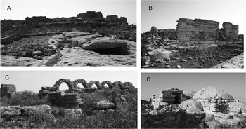
Views of Mghernes. (A) One of the fortified buildings and its related cisterns; (B) the so called Fortified Palace; (C) view of the East Church; (D) the baths.

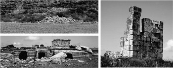
Although Mghernes often has been referred to in publications as a site unique of its kind, such villages are quite common and located at regular intervals along the road on the upper terrace of the Djebel Akhdar. For instance, one of the lesser known, but among the most monumental, is Om Sellem (Fig. 3), a large Late Antique oil-producing settlement, as the well-preserved oil-presses suggest. The site is best known for its two monumental Christian basilicas (three-aisled, with central apse albeit with opposite orientation) and a vaulted triconchos building (inspected by Ward-Perkins in 1969 and later by Joyce Reynolds in conjunction with her work of editing the notes of Goodchild and Ward-Perkins [Reference Ward-Perkins, Goodchild and Reynolds2003, 362–363]). Both churches show two phases of construction and a possible late phase of partial re-use, after a period of marked decline of the building, probably dating to after the Arab conquest. It is a well-organised village, with the remains of numerous workshops for oil production, several buildings, and, just outside the settlement, large ancient quarries and a cemetery, all of which attest to the longevity of the site. In the cemetery, the presence of Hellenistic rock-cut tombs is notable, showing much later re-use, as well as two large built tombs, which could be interpreted as Roman mausolea, for their building technique and architectonic features. The preliminary surface survey of the area has yielded pottery dating to between the second century BC and the sixth century AD.
Om Sellem: views of the site.

As with many of these villages, the period between the fourth and the sixth century is the most widely attested and is probably the period of maximum flourishing. This seems to be the moment of a large oil production in all these villages as well as a robust building programme, resulting in both fortified buildings and monumental basilicas.
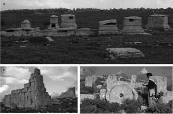
Another important village which deserves mention is located not far from Mghernes: Gebbra/Jubbra (Fossataro Reference Fossataro2008; Stucchi Reference Stucchi1975, 506), a fairly large settlement, but almost completely unknown. This village attests more clearly the phases of development of this type of settlement, beginning as a large farm or small village, with oil presses, large open-air rock-cut cisterns and small outbuildings. The nearby cemetery is characterised by sarcophagi and small temple-tombs, consisting of loculi built in a more monumental way as small shrines, also known at Cyrene but not widely used there. Their use seems to date from the late Hellenistic period to Roman times, as the architectonic features and the niches for Romano-Libyan portraits seems to suggest (Fig. 4).
Jebbra/Giubbra: (A) the tombs; (B) the fortified building; (C) view of presses and mills.

However, probably around the second half of the fourth century AD, the centre of production was extended and new and larger press systems were built, to the extent that the earlier tombs were included within the new buildings. This new phase of the village saw also the construction, probably slightly later, of a fortified building (Fig. 4), which has been preliminarily interpreted as a ‘fortified palace’ (Stucchi Reference Stucchi1975, 506), but which may have been a fortified granary for the safekeeping of local produce (Fossataro Reference Fossataro2008) as well as a refuge for domestic animals, if the small, well-preserved basins are correctly interpreted as water-troughs.
Aims and preliminary results
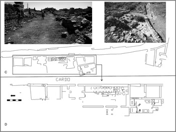
The choice of Lamluda as a sample-site for excavation, mapping and stratigraphic testing of the main phases of use is due to its well-preserved stratigraphy and monumentality, as well as for its interesting location (Figs 1 and 5), at the crossroads between the limes and the west–east and north–south roads, linking the centre with several harbours on the coast, as well as with other sites in the countryside. The role of this settlement within a border territory is clearly attested also by its ancient name Limias, which is mentioned in both the Itinerarium Antonini (IA 68, 70) and the Tabula Peutingeriana.
Lamluda: views of the cardo (A and B); general CAD-plan of the cardo (C); plan of the insula of the wine workshop.

The project continues to be possible thanks to a close collaboration with the DoA of Shahat, which has been directly involved as partner in the research, with a joint Italo-Libyan team working in the field. Survey and excavations have shown that the site had a long and interesting life, with the earliest finds, mainly pottery, dating to the Hellenistic period, from around the second century BC. This phase of the settlement is extremely difficult to identify and delimitate, as the later phases obliterate the earlier structures. Our findings seem to suggest an initial small settlement, probably consisting in farms, exploiting the fertile upland plateau surrounding the site, which is particularly suitable for the cultivation of cereals, vines and olives. A few late Hellenistic rock-cut tombs around Lamluda and Hellenistic tombs along the road from Lamluda to the coast also support the hypothesis of limited settlement in this territory since the Hellenistc period.
Looking at the plentiful funerary finds from the site, mostly consisting of more than 40 anthropomorphic tombstones, most published by Bacchielli (Reference Bacchielli1987) and Bacchielli and Reynolds (Reference Reynolds and Bacchielli1987), with three more found during the recent surveys (Menozzi forthcoming). These date mainly to Early Roman times, and it could be hypothesised that between the end of the first century BC and the second century AD the settlement saw a transformation into a village proper, probably already with an organised but simple plan. It seems reasonable to compare this phase of Lamluda with the contemporary evolution of Mghernes into a village, attested by epigraphic sources (see above).
Even after only a preliminary analysis the numerous tombstones and other funerary finds are yielding interesting results from a historical and archaeological point of view, as they range from the Early Roman to the Mid-Imperial, the least well-known period of the settlement.
The anthropomorphic tombstones (Fig. 6) belong to two main types: completely aniconic and very crudely iconic, but always without any physiognomic intent. They are attested in abundance at Lamluda, representing for this area one of the best testimonies of the impact of Roman culture and customs on an indigenous Libyan substratus, still strongly linked to local Libyan culture, while manifesting a basic level of ‘Hellenisation’, at least in the use of Greek in the brief inscriptions, but otherwise very far from the strongly Graeco-Roman cultural and ‘artistic’ contemporary funerary finds from Cyrene. Probably in this territory, just at the limits of the limes, Libyan tribes and Graeco-Roman settlers shared more easily and for a long time, not only the fertile lands, but also some aspects of the local tribal culture.
Anthropomorphic tombstones found during the surveys, now in the storeroom at Shahat; views of the tomb where the tombstones were found.

It is conceivable that for long time the two groups mingled with each other, through mixed matrimonies, slave manumissions and/or adoptions, alliances, common economic exploitation of the area and reciprocal trade. Lamluda would have functioned as the market centre of a wider productive countryside without proper economic boundaries.
Libyan names, in a Greek transliteration, are attested on the anthropomorphic tombstones (albeit only on a small percentage of them), testifying to a long survival of Libyan names (for percentages see Figure 7) despite a lengthy exposure to Greek and Roman customs. Most of the tombstones display Greek names contemporarily in use at Cyrene, probably widely employed throughout the chora because they were fashionable and no longer held ethnic connotations.
The percentages of ethnic names attested in the inscriptions on the anthropomorphic tombstones.

The Roman names feature on 24% of the tombstones, in the form of tria or duo nomina, both for males and for females; most of the Roman names are attested in a Greek transliteration, but in one case also Latin is attested, on the tombstone of Caius Iulius Epafroditus (Reynolds and Bacchielli Reference Reynolds and Bacchielli1987, 506 n. 22). The same scholars have suggested (ibid. Reference Reynolds and Bacchielli1987, 494–495, 501, 506) that the individuals with Roman tria and duo nomina could be veterans, or their direct descendants. It is plausible that soldiers coming from the Lamluda area had served in the III Legio Cyrenaica,Footnote 1 and therefore participated in land distribution schemes in the area, probably during the earlier campaigns of this legion, between 36 BC and the Julio-Claudian period. Most of these tombstones date to the period between the end of the first century BC and first century AD. Some of the inscriptions have a very definite date, as they mention the time around the Battle of Actium, again with strong military implications.
Other names and words in these inscriptions are of difficult interpretation, but among them two cases seem to be attributable to a Greek-speaking Jewish community, probably settled in Lamluda, which could also explain another ‘unique’ use of the word γερων used to indicate, in one of the inscriptions, the appurtenance of the dead man to a ‘community of elders’, well known particularly in Jewish contexts (for a discussion about a γερουσία in Greek-speaking Jewish communities see Barlett Reference Barlett2002, 16–18). It is certainly possible that a Jewish group was settled in Lamluda, as well as in Cyrene and other sites of the region; as the Jewish rebellion of AD 115–117 was particularly fierce in Cyrene, this could be seen as an indication of a large local Jewish community at that period. Prior to that date it probably coexisted peacefully with the pagan Graeco-Roman population, even living in mixed Judaeo-Christian communities, as attested elsewhere (Stern Reference Stern2008, 255–257). An epigraphic source of the mid-first century BC from Berenike attests an important and well-integrated Jewish community in the region, even mentioning the reconstruction of a synagogue in Berenike (Barlett Reference Barlett2002, 33–57).
The considerable number of aniconic versions of these anthropomorphic tombstones could also be explained by the common use of plain stones used by the Jews as simple markers for their tombs (Stern Reference Stern2008, 295–296). The possibility of a Hellenised/Romanised early Jewish community at Lamluda will be investigated more thoroughly in subsequent studies, but it could also explain the unusual nature of the funerary complex (Fig. 8) near the West Basilica (Ward-Perkins and Goodchild Reference Ward-Perkins, Goodchild and Reynolds2003, 299–302). According to the Jewish funerary customs, their community, often together with early Christians, used rock-cut complexes, characterised by a subterranean courtyard, probably due to the influence of Alexandrine funerary architecture, with a descending staircase, and funerary chambers located on all four sides of the courtyards, as in the case of the funerary complex at Lamluda, but also attested in Tripolitania, Tunisia, and even Israel (Hachlili Reference Hachlili2005, 34–40; Stern Reference Stern2008, 255–257, 276, 281–283). A reasonable objection to this is that rock-cut tombs are very typical of Cyrenaican funerary architecture. However, completely subterranean courtyards in the Alexandrine style are quite rare in the region, with (generally) open courtyards at street level or just below and never surrounded by tombs on four sides, as in this case. The complex at Lamluda has been used over a long time and its first phase seems to date to between the first century BC and the first century AD; it continued in use over a considerable time, enlarging the rooms and transforming the complex into a sort of catacomb. A good parallel for its plan, phases and long continuity of use is to be found in the so-called Jewish Catacomb of Gammarth in Tunisia (Stern Reference Stern2008, 255–261, 283), which was used by a mixed community of Jews and early Christians. Continuous occupation of the site until the fourth or fifth century AD, and the possible ‘memory’ of an early Christian and Jewish community, could have been the main reasons for building an extra-urban basilica just above and closely linked to the funerary complex (Ward-Perkins and Goodchild Reference Ward-Perkins, Goodchild and Reynolds2003, 299–302).
Lamluda. The funerary complex just below the western church.

Returning to the evolution of the settlement, the original small Hellenistic settlement was probably gradually transformed in Roman times into an urbanised settlement (Fig. 9), with a regular town plan based on the intersection of a main cardo with several decumani, and with a sort of large ‘forum’, facing towards the pre-desert and acting as market/caravanserai, thus serving the economic and political functions typical of fora and conciliabula settlements within the Roman Empire. The status of ‘town’ is attested for this site in the Late Roman and Early Byzantine period by an inscription dating to the sixth century AD (SEG XX, 705), coming from a tomb in Bir Takakenet (Stucchi Reference Stucchi1975, 358–359) which mentions Limnias among the poleis.
General aerial view of Lamluda showing the main phases, buildings and excavations.

In the Late Byzantine period and certainly during the early Islamic phase, the town plan changed markedly (Fig. 9), with the partial reconstruction of the Urban Church and a possibly related nearby building, as well as a fortified building, changing the layout of the village, restricting the cardo maximus, and occupying the area of the forum and the decumanus. In this way the access to the town centre became limited, and control could be exerted not only over the people, but also on the goods entering and exiting the settlement.
Lamluda, and similar sites such as Mgernes, Jebbra, Gabu Younis and Om Sellem, are good examples of larger villages managing the agricultural exploitation of the region in Late Roman times, thanks to their position in highly fertile areas, along the main road network, at the intersection of the roads linking East and West and the southern desert areas to the coast, cutting the three main fertile terraces of the Djebel Akhdar. Looking at the huge number of presses and storerooms with dolia/pithoi, still very well-preserved in most of these villages, and in particular at Lamluda, it seems conceivable that the economic vocation of these sites was based on the production and export of local wine and oil, especially in the period between the fourth and the seventh centuries AD, with a floruit between the fifth and early seventh centuries (Catani Reference Catani1976; Reference Catani, Catani and Marengo1998).
Across a large area around Lamluda it is possible to see the numerous presses still in situ, in some cases certainly used for wine production (e.g. the one in the city centre), but mainly for oil; many such presses have already been mapped in the outlying areas of the settlement (Menozzi forthcoming). The publication of the research of Dr A. Buzaian, who has located, planned in detail and organised into a local typology the huge number of presses in this region, will certainly be a fundamental step forward in their study, dating and interpretation. The pottery finds dating to the later period of the village seems to confirm this large productivity, with numerous amphorae and other containers, related to local production and its export outside Cyrenaica.
The excavations of 2008, 2009 and 2010 were focused on three main areas, two of them (A and B in Fig. 9) along the cardo and a third one in the area between the cardo and Basilica (Fig. 9, G), in a position were apparently a decumanus was at a certain time blocked in two points in order to create a small shelter or house. Moreover, the cardo and the area (Fig. 9, F) between it and the fortification (Fig. 9, E) have been completely cleared and documented, with a careful analysis of the late structures by our colleagues from the Medieval team (Prof. Maria Carla Somma and Dr Sonia Antonelli). The finds are being studied, and we still need to complete excavation in some areas, but it is possible to draw some preliminary conclusions.
The clearing of the cardo and the area between cardo and basilica (Fig. 9, G) has given the possibility to analyse more carefully later interventions, such as the building of late structures (e.g. the square fortification, [Fig. 9, E] occupying the area of the ‘forum’ and the small rooms built to the north [Fig. 9, G] and certainly related to it), shrinkages of the cardo limiting the access and causing changes of alignment, the blocking of the decumani, which certainly dates to the Late Byzantine phase (between the second half of the sixth and early seventh century AD). Moreover, the excavation in the two complexes along the cardo (Fig. 9, A and B) has also shown that with the Arab conquest the houses were built on top of earlier collapsed buildings, re-using some building materials and creating a higher floor level. The characteristics of the collapse suggest a particularly powerful geological event, probably an earthquake, dating to between the end of the sixth and mid seventh century AD.
An important moment for the settlement must have been the period between the fourth and mid sixth centuries AD, when the wine and oil production was at its peak. There were earthquakes during that period as well, notably the famous and well-attested earthquakes dating to between the mid fourth (AD 365) and to soon after AD 400. These events were probably the cause for the reconstruction and reorganisation of the wine workshop excavated by Goodchild in 1956, recently published in a preliminary report by A. Buzaian (Reference Buzaian2009, 47–54) and now completely excavated by our team, discovering more than 20 dolia sunken into a well-built cocciopesto pavement (Fig. 10). Analysing the poor stratigraphy left by Goodchild's excavations and the relationships of the structures, the complex seems to have had four main phases of use (see Figure 10, showing the main phases of construction): the primary phase when used as a wine workshop, with a large storeroom containing numerous dolia, attesting a large production of wine in the rooms with presses, basins and tanks; a second phase of the storeroom with the restoration of some of the walls and the rebuilding of others over the earlier, evidently damaged structures. This could also be the phase of construction of the large arches, intended to support the storerooms and to elevate a second floor; a third phase of construction of the wall just in front of the arch, partially blocking not only the passage through the arch, but mainly part of the dolia and greatly reducing the storeroom, which probably changed its function in this Late Byzantine phase, judging by the building technique; a fourth phase seems to be attested by the upper level of structures on the walls of the complex, with an occupation level, identical in the rooms on both sides of the cardo, and about 1 m above the level of the pavement with the dolia. However, in this area previously excavated by Goodchild only further (proper) excavations could date these phases more precisely. The same applies to the building on the opposite side of the cardo, where work has recently begun under the direction of our Spanish colleague and Islamic Archaeologist, Dr Jesus Lorenzo, from the University of Pais Vasco, Spain.
The storeroom in the insula with the wine workshop.

Certainly the settlement in the final phases, just after the Arabic conquest, must have kept its important role for the management of the local production, because most of the settlement shows remains of these phases, including also an architrave with Islamic decoration and inscription (Fig. 11), opening with an Invocation from the Koran (Sura 3, Al-Aya 1) and mentioning the name of the owner of the house, Sa ‘īd ibn Yūsuf (the inscription and its decoration are being studied further).
An Arabic inscription from Lamluda, now in the Museum at Cyrene.

Coarse ware and amphorae from Lamluda: preliminary analysis and report (S. Antonelli)
The settlement of Lamluda is an important example for the study of the historical and socio-economic conditions in late Antiquity and the Byzantine period in Cyrenaica, mainly thanks to its position on the east–west road system connecting Cyrene to Egypt, and on the north–south road network linking the pre-desert area and the coast.
The pottery from the 2008 and 2010 excavation seasons can be seen as an indicator of living conditions in the settlement between the sixth century AD and the Arab conquest. It contributes to a better understanding of the local way of life, the chronology of the site and local production which are attested by the numerous remains of oil presses still preserved around the village, signalling a notable economic development of the chora in late Antiquity (Catani Reference Catani, Catani and Marengo1998, 114; Roques Reference Roques, Barker, Lloyd and Reynolds1985; Wilson Reference Wilson2004).
Studying coarse wares and amphorae is a means to chart their circulation and/or production in Cyrenaica, an area which was culturally linked to the eastern Mediterranean basin. There are few specific publications on this area and subject except for Riley's studies on Apollonia (Reference Riley1981) and Berenice (Reference Riley and Lloyd1979) and the excavations at Tocra (Boardman and Hayes Reference Boardman and Hayes1973), unlike in the neighbouring Tripolitania and Byzacaena. Enrico Zanini's approach (Reference Zanini, Menchelli, Santoro, Pasquinucci and Guiducci2010, 139) is followed here, focusing more on the use a vessel is intended for rather than principally on the evolution of particular forms; an approach the present author finds both congenial and suitable to the circumstances.
The recent events in Libya have prevented the mission from completing the catalogue of the large number of finds, and it is therefore impossible to present here a complete chronological type series, since the data available concerns only 40–45% of all the material collected. The sample (about 1000 catalogued sherds, c. 700 grouped by fabric) is highly fragmentary, with poor diagnostic elements for a morphological identification.
Notwithstanding the scarceness of data (mainly retrieved from destruction and rebuilding phases) regarding the development of the site, the sample is quite homogeneous, with few phaenomena of intrusion and a limited range of residuality.
The sample includes amphorae (61.9%), coarse ware for food preparation, serving and storage (29.7%), cooking ware (5.6%), and fine wares (2.8%). Open forms account for only 4.76% of the total, with some uncoated vessels for food preparation and storage, but mostly fine table wares, such as African H104B and H107 (Atlas I Reference Atlante1981, 95 pl. XLII, 5–6 and 102 pl. XLVII, 7–8).
Cooking ware (Fig. 12)
This is mainly represented by closed forms, such as pots and ollae made up of dark, grayish-brown fabrics (IMP1 [site-specific fabric denomination] Munsell 10 YR 4/2 dark greyish brown, IMP2 and IMP3 Munsell 7.5 YR 4/2 brown;), quite soft, hand-modelled or slow-wheel-turned. Its surfaces are occasionally polished with sticks, with wide angular limestone inclusions and curious microfossils coming from regional sediments (IMP3), thus attesting with certainty a local production, similar in shapes and features to the heterogenic family of the Calcitic Ware. Technological and archaeometric aspects of such cooking ware have been recently clearly outlined (Bonifay et al. Reference Bonifay, Capelli and Polla2002–2003; Polla et al. Reference Polla, de Vos, Ischia, Gialanella, Capelli, Bonifay and Tréglia2007), emphasising a constant presence of ground/crushed limestone sedimentary materials, probably aiming to lower the risk of heat shocks.
The fabrics are quite diverse and this reveals the existence of several production centres, as also attested in Northern Tunisia (Capelli and Bonifay Reference Capelli, Bonifay, Bonifay and Tréglia2007, 555). As for the shapes, all attested in IMP3 fabric, they seem to be ascribable to the late Roman Mediterranean repertory – such as, for example, the finds from the Balearic Islands, where the same forms are very common, but with micaceous fabrics (Cau Ontiveros Reference Cau Ontiveros, Bonifay and Tréglia2007, 235, Fig. 3).
The functional character of this pottery is quite similar as far as their morphology is concerned. The pots are roughly hemispherical, with a slightly inverted rim, rounded or squared, with horizontal handles, often hollowed, with a diameter of between 14 and 22 cm (Fig. 12). The inverted rim was intended to facilitate the slow cooking of food, a characteristic feature of the Mediterranean diet.
The main pottery forms attested at Lamluda.

The finds from the mainly residential areas F and G may be compared to Late Roman Cooking Ware 1E which has been found at Sidi Khrebish (Riley Reference Riley and Lloyd1979, 269–270, D538–D544, figs 105 and 106), dating to the first half of the sixth century and characterised by a very similar fabric, Local fabric 1.
However, many comparisons could also be made from an ethnographic point of view, thanks to the extraordinary longevity of this type of vessels in North Africa (Polla et al. Reference Polla, de Vos, Ischia, Gialanella, Capelli, Bonifay and Tréglia2007, 603), presenting evident problems of chronological attribution, due to the lack of reliable stratigraphic contexts.
Archaeometric analyses on Lamluda's cooking ware have highlighted the presence of chamotte within these fabrics (at least in the IMP3 fabric), testifying to a certain technological skill even though these products were destined to a micro-regional or ‘local’ market and to small-scale trade, which was more profitable for non-valuable manufactures. It should be remembered that ‘highly technological’ cooking ware in some cases entered larger markets, such as the case of Pantellerian Ware (Santoro et al. Reference Santoro, Guiducci and Tusa2003; Santoro Bianchi Reference Santoro Bianchi, Gurt i Esparraguera, Buxeda i Garrigós and Cau Ontiveros2005).
Coarse Ware (Fig. 12)
Vessels used for food storage and/or serving represent a significant part of the sample. A limited number of fragments have been identified – mostly jugs for the storage of liquids or pouring, bowls for food preparation and globular ollae with everted rims and pronounced bases (Fig. 12). They all have in common an orange, quite hard and rough fabric, with a neat fracture and white quartz mineral inclusions and pedorelicts (so-called red earth) (CD7 = CD11 Munsell 2.5 YR 4/8 red).
An important fragment of a small trilobed jug has been found, with a single oval handle, a cylindrical neck noticeably narrowing from the hemispheric body (Fig. 12), which comes, together with a high number of amphora fragments, from one of the de-functionalised dolias embedded in the floor level of the storeroom on the western side of the cardo. This jug gives a terminus post quem for dating the discontinuation of the usage of dolia and can be convincingly compared with a small jug found at Sidi Khrebish (Fig. 13), dating to between the second half of the sixth century and the beginning of the seventh century (Riley Reference Riley and Lloyd1979, 394, D1191 fig. 142).
A Jug from Lamluda (left) and its parallel from Sidi Khrebish (after Riley Reference Riley and Lloyd1979, 394, D1191 fig. 142).

Another quite capacious vessel, with a wide, flared rim and two oval handles, is quite similar to other examples found in Berenike, the so-called flagons (Riley Reference Riley and Lloyd1979, 398, D1216 fig. 144), dating to the first half of the sixth century. The two-handled jugs with a long cylindrical neck, known as Keay LXXIX or Bonifay 48–49 (Reference Bonifay2004, 295, fig. 157) were probably used for pouring wine, and two narrow rims which have been found in association could be related to them.
These are very common vessels in the Mediterranean area, circulating from the third to fourth century until the Post-Byzantine period; in this context they can be dated to the first half of the sixth century, along with other smaller bowls and ollae (Fig. 12). A very capacious, open vessel with a flared shape is made of the same fabric. It presents relief decoration on the rim, similar to Mid-Imperial Roman vessels (Riley Reference Riley and Lloyd1979, 356 D973 fig. 129). It can be dated to the end of the fifth – beginning of the sixth century by stratigraphic association (area 6, US 6059). Some jugs with a plain base (diameter 12–15 cm) and short and slightly everted rim may be ascribed to the same period; their fabric is brown in colour (CG4, Munsell 10 YR 3/2, very dark grayish-brown), very strong and rough, neat fracture, scarce traces of pedorelicts and small white quartz mineral inclusions.
A vertical-sided casserole with a brief horizontal rim was destined not only to food preparation but also used for cooking. It is characterised by a coarse, not very strong fabric, with large limestone inclusions and irregular fracture (CG5, Munsell 2.5 YR 5/6 red), dating to the first half of the seventh century (area 6 sector E, US 6102).
Storage wares and amphorae
There are a significant number of fragments belonging to amphorae, especially in area 4, where their percentage rises up to 71.9%, and in the storeroom with dolias along the cardo. This urban space could thus hypothetically have been used as a store for local produce, at least in the mid sixth century. The examples of LRA1 come from these two areas. They have very high sides and fragmentary handles, a pale brown fabric, with black and red inclusions and a rough surface (A5 Munsell 10 YR 8/4). Archaeometric analyses have shown that because of its volcanic inclusions the fabric of this vessel certainly does not belong to a North African production, and it seems more likely to come from Cyprus. Cypriot LRA1 amphorae become more common especially after the second half of the sixth century, following the crisis in the Cilician production. Products from Cyprus boomed at the beginning of the seventh century, when the amphorae travelled the whole Mediterranean, reaching the most remote corners of the Danubian limes, probably as vessels to transport wine for the army (Pieri Reference Pieri, Bonifay and Tréglia2007, 614). A Byzantine military station in Lamluda is a plausible hypothesis given the strategic position of the site, at a crossroads and along the Roman limes. This hypothesis seems to be confirmed by some changes in the town plan, such as the narrowing of the cardo through the construction of a massive defensive structure. A station on the limes could well have deserved the toponym Limnias (then corrupted into Lamluda), attested in the Itinerarium Antonini (Limniade 68, 70), where it is mentioned as a stop just after Cyrene (see above; Cuntz Reference Cuntz1990; Fantoli Reference Fantoli1933, 127).
There is an example of LRA2 from area G. It has an elongated profile, especially at the neck, which may be compared to late productions between the end of the sixth and the beginning of the seventh centuries. It is characterised also by very thick horizontal grooves on the shoulder and by a wavy motif on the neck (Fig. 12). As in the case of LRA1, here too we have a fabric different than the other amphora samples, orange turning to gray on the interior (Munsell 2.5 YR 5/6 red and 7.5 YR 4/4 brown), untreated, with inclusions of mica and quartz, (CG19, cf. Fig. 15). The fabric, rich in quartz, is compatible with an Aegean production: from there it spreads throughout the Mediterranean and central Europe. In this case too, the presence of such examples in sites on the limes has been directly related to the annona militaris (Karagiorgiou Reference Karagiorgiou, Kingsley and Decker2001).
The perspective on imports and commercial contacts broadens if we look at a rim fragment of LRA17 /Keay LXII, a variation of the so-called ‘Africana Grande’ attested in Leptis Magna between the first half of the fifth century and the end of sixth century (De Miro and Polito Reference De Miro and Polito2005, 95), in Cyrenaica and in Berenike during the first half of the sixth century (Riley Reference Riley and Lloyd1979, 204 D281 fig. 87). Our example dates stratigraphically to the end of fifth – beginning of the sixth century, found along with an example of Keay L or Bonifay 51 (2004, 141–142, fig. 76.3) from the middle of the seventh century. The Arab conquest did not affect the site's relational and productive capacity, at least not at first. A reason for this may be that, as already mentioned, the settlement was actively participating in a quasi industrial-scale production of olive oil in particular. A significant number of LRA13 amphorae sherds can be dated to the same period. Their fabric is very pale brown, quite hard, with inclusions of small quartz, quite dusty and covered with a thin layer of light engobe (CI1–A2 Munsell 10 YR 7/4, very pale brown). LRA13 are significantly attested in Berenike and Apollonia (Riley Reference Riley and Lloyd1979, 231–232, D375 fig. 94) during the middle of the sixth century. The origin and diffusion of such amphorae has not yet been clearly defined (Demesticha Reference Demesticha, Briese and Vaag2005), although archaeometric analyses on Lamluda's samples have underlined the presence in their fabric of microfossils which testify to a local production, in conjunction with the agricultural activities in the area. Such activities may be better outlined on the basis of an amphora fragment found in the storeroom of the wine workshop. It presents a crude graffito, incised with a stick before the vessel was fired (Fig. 13). The inscription is clearly Christian and is essentially an invocation of protection, dating to between the sixth and the seventh century (see Appendix 1 below for palaeographic and epigraphic comments). The graffito could be a fascinating indication of the complex dynamics involving the clergy in the management of agricultural production (see Bernal-Casasola Reference Bernal-Casasola, Menchelli, Santoro, Pasquinucci and Guiducci2010 for a thorough discussion on the topic, based on inscriptions on amphorae). This possibility, that the clergy was involved in the agrarian rural economy, could help to explain the monumental presence of Christianity in a settlement like Lamluda, which counts among its buildings skilfully built both urban and suburban basilicas.
Appendix 1
Epigraphic and palaeographic analysis of an inscription on a pottery fragment from Lamluda (A.C.)
The inscription is incised on a sherd belonging to a transport or storage container, from the village of Lamluda (Fig. 14):
ΒωΗΘΕ
Verbal form with the lengthening of -omega intended as the imperative of βοηθέω, ‘help’. It refers to the usual invocation and call for help formula of the Christian epigraphic repertoire (Guarducci Reference Guarducci1978, 305–7), which is usually preceded by a nomen sacrum in the vocative (usually Κύριε, Χριστέ or also Θεοτόκε)Footnote 2 and, if it is not used in absolute form, can take the dative (as well as the genitive or accusative) or of the person (often expressed with the appellative τῷ δούλῳ) or of the object demanding protection. This sort of formula, variously attested also in abbreviated forms, was extensively used on all kinds of items throughout the Late Roman and Byzantine period.
Ceramic fragment with a Christian inscription.

The lengthening of the vowel -omega in the verb, may be a clue indicating a late period date (Debrunner and Scherer Reference Debrunner, Scherer and Giganti1969, 99–108), but may also provide further evidence of the persistence, in the Cyrenaean epigraphic system, of the phenomenon of confusion about the vowel quantity of -epsilon/-eta; -omicron/-omega, continuously attested since the end of the second century BC onwards (Dobias Lalou Reference Dobias Lalou2000, 24–5). It was due not only to a phonetic flattening in fieri between the indigenous or semi-Hellenized inhabitants but also to the progressive loss of the vowel quantity.
This phenomenon, in the βωήθε- form, finds at least nine other epigraphic occurrences: in Syria (two), Amman (Arabia), Eilath (Palestine), Phrygia, Cappadocia, Athens, Amasia (Pontus) and on Syros in the Cyclades (IGLS IV, 1754; IGLS V, 2116; IGLS XXI, 2, 46; SEG XXVI, 1661; Orlandos Reference Orlandos1937, 141 n. 19; De Jerphanion 1936 II, 63; Dinsmoor Reference Dinsmoor and Orlandos1967–68, 151; Studia Pontica III, 135; IG XII 5, 712, 73).
There are also two further instances of the lengthened βω- form, respectively from the House of Jason Magnus at Cyrene (Gasperini Reference Gasperini, Arnaldi and Marengo2008, 100–101 fig. 43), and from Apollonia (Reynolds Reference Reynolds1965–67, 293–334 n. 50; SEG XXVII, 1179), both on pottery fragments.
Considering the numerous examples of the formula and their chronological and geographical variations, the verb βοηθέω can be found in several variants, presenting in the majority of the occurrences in the form βοήθει, although there are also testimonies of the imperative βoήθε (for example, SEG: XLIV, 628 A; SEG XXVIII, 1404; SEG XXXIX, 1237; IG IX, 2 756; IG XII, 7 144; IGLS V, 2535; Inscr. Byz. 284 n. 47; EAD 30, 185; IGUR I, 102a) and of the βοήθεσον form, attested only in Asia Minor and Egypt (e.g. SEG VIII, 744 and 750; SEG XXVIII, 1404Footnote 3 ; SEG XXIX, 1321; SEG XXX, 1716; IGLS II, 563; Jarry Reference Jarry1967, 175 n. 81 and 206 n. 151; Faras IV, 150 n. 94; SB IV, 7499 and 7505). Considering then the comparisons with the instances of the verbal form in -omega, there are both the βωήθεσον variant, which seems typical of the Arabic-Palestinian area (IGLS XXI 2, 46; SEG XXVI, 1661), and the βωήθει form (IGLS IV, 1754; IGLS V, 2116; Orlandos Reference Orlandos1937, 141 n. 19; De Jerphanion Reference Jerphanion de1936, II, 63; Dinsmoor Reference Dinsmoor and Orlandos1967–68, 151; Studia Pontica III, 135; IG XII 5, 712, 73), that, in the most ordinary usage βοήθει (i.e. without the vowel lengthening), is identifiable in one of the mosaic inscriptions from the House of Hesychius in Cyrene, dating to the fourth century ADFootnote 4 (SEG XVIII, 746; SEG XXX, 1785 fr. 1).
In addition to the inscriptions from the House of Hesychius and from Apollonia, it seems that –according to the current state of the discoveries – other examples can be identified, including respectively five from Cyrene, on stone supports (SEG IX, 187 and 188; SEG XVIII, 754; SEG XXXI, 1578), and three from Apollonia, on stone and ceramic supports (Reynolds Reference Reynolds1965–67, n. 29, 36, 45), dating to the fifth-sixth centuries AD. They bear the invocation and call-for-help formula, either shortened or in the Κύριε βοήθησον form, both absolute and associated with a genitive, dative or accusative indiscriminately.
The ceramic fragment from Lamluda adds a sliver to the corpus of Cyrenaean inscriptions with the Christian formula of invocation and protection, distinguishing itself as the third text in the form βωηθε- with the lengthening of -omega in the verbal theme, discovered thus far in the territory of Cyrene.
It is also clear that inscribing this kind of formula on pottery intended for transport and storage use was a fairly widespread practice in the Cyrenaean area, as evidenced by the fragment from the House of Jason Magnus at Cyrene (Gasperini Reference Gasperini, Arnaldi and Marengo2008, 100–101 fig. 43), the two examples from Apollonia mentioned above (Reynolds Reference Reynolds1965–67, n. 36, 50) and naturally also the present inscription from Lamluda.
Taking into account the potential geographic and linguistic comparisons, the following integration could be assumed:
[Κύριε] βωήθε[ι]
It is not possible to advance assumptions on the possibility that the formula was absolute or not, because of the angle of fracture of the ceramic fragment.
From a palaeographic point of view, the inscription, roughly inscribed in informal capitals with a tool of considerable thickness, presents a slight inclination of the graphic axis (particularly evident in -beta), probably due to the instrument, the writing support and to the writer's will.
The ductus is swift but accurate and it is possible to perceive, in the graphic chain, a modular contrast intended and achieved through the shrinking of -omega and -epsilon. This latter feature, combined with the elongated rod of -theta and the -epsilon in rounded shape, revisits the ogival capital with inclined axis environment (Crisci and Degni Reference Crisci and Degni2011, 111–19), whose period of diffusion is placed, as we know, between the sixth and the ninth century AD.
It is also possible to establish some comparisons with graphic examples, on pottery and lithic supports, respectively from Egypt and Crete, territories with which Cyrenaica was in continuous cultural, artistic and historical osmosis.
The smoothness of the ink lettering on Greek and Greek-Coptic ostraka, from the Egyptian sites of Abu Mina and Tell Edfu and all dating to the seventh century AD, allows us to establish relevant comparisons with the rough inscription from Lamluda. Specifically, a religious inscription on an ostrakon from Tell Edfu with the text of a Psalm in Sahidic shows strong similarities with the writing of this inscription, from the inclination of the axis to the outline of the letters (Bacot Reference Bacot2009, 19–21).
The comparison with scribe G's hand on the ostraka of Abu Mina (Litinas Reference Litinas2008, 30, 189, 198, pl. XV) seems to be less striking, due to the lack of inclination of the writing axis and to the absence of -theta in the documented testimonies. The forms of -epsilon, -theta and -omega, however, are very close to the writing at Lamluda, still referring to an environment of the end of the sixth – middle of the seventh century AD (Litinas Reference Litinas2008, 16–23). This parallel is also geographically very close to the historical and cultural panorama of early Byzantine Cyrenaica.
Palaeographic comparisons with Christian inscriptions on Crete, closely linked to Cyrenaica, are also very helpful, not only for the political implications of the Roman domination, but also for the similarity of the artistic influences. The majority of the Christian inscriptions of Crete show a steady hand and the letters sometimes assume a rounded shape, close to a cursive style (Bandy Reference Bandy1970, 23–5). Even considering the differences of material and writing implements, the comparison with two inscriptions dating to the sixth or seventh century AD is appropriate: one from Plora (ancient Pyloros), presents a rounded style and an outline similar to the inscription of Lamluda (Bandy Reference Bandy1970, 85–6 n. 58); another, from Hagioi Deka, still has a rounded shape and a similar style of the letters, especially of -epsilon and -omega (Bandy Reference Bandy1970, 46–7 n. 17).
The Christian inscriptions of Crete also help in establishing a palaeographic comparison with the roughly inscribed graffito on a sherd from the House of Jason Magnus at Cyrene that has a Christian invocation formula which is very similar, especially in its linguistic characteristics, to the inscription of Lamluda (see above, Gasperini Reference Gasperini, Arnaldi and Marengo2008, 100–101, fig. 43). The form of the single letters, mainly taking as a reference -beta, -lambda, -sigma and -omega, harks to the fifth–sixth century AD (Bandy Reference Bandy1970, 38 n. 6, 70–1 n. 40, 130 n. 101).
With the help of the Cretan comparisons, it is thus possible to find a suitable chronological point of reference for two particularly representative Cyrenaean documents: the inscriptions of the House of Jason Magnus and of Lamluda. Both belong to a literate and Christianised environment and trace a palaeographic progression in Cyrene between the fifth and the seventh century AD.
Appendix 2: Preliminary results of the third step of the archaeometric analysis (M.C.M. and S.A.)
The approach to the pottery finds from our survey is based on a combination of technological and petrological methods, aiming the identification and characterisation of the fabrics of local and imported wares.
Protocols and analysis
Considering the large number of pottery fragments, collected during our surveys and excavations at Lamluda, it seems likely that the economic role of the site was based on the production and export of local products, as well as importing materials and different products from around the Mediterranean, especially from the Late Imperial period through to the Arab conquest. The pottery finds dating to these periods seem to confirm high productivity, mainly agrarian, with numerous amphorae and other containers, certainly related to the local oil, wine and perfume production and their export from Libya. The study of the pottery has been based on protocols common to our projects both in Libya (Antonelli and Menozzi Reference Antonelli, Menozzi, Poulou-Papadimitiou, Nodarou and Kilikoglou2014) and in other areas of the Mediterranean basin, especially on Cyprus (Mancini and Menozzi Reference Mancini and Menozzi2012). In order to have a base from which to collect samples for further study the fabrics are studied by means of a scanning microscope in the field as a first step. A second step, still in the field, is dedicated to the geomorphological analysis of the territory, with sampling of the local clays, soils and sediments, specifically collected by geologists, in order to have possible reference samples for the local productions. The third step, in a laboratory, is based on EDX and TSA analysis, for a further grouping of the fabrics. Only a few specific samples of fabric are then chosen for further investigations, such as SEM analysis, with a fourth step limited to problematic or unusual fabrics.
Because the amphorae and other containers were exported for their contents, we are also attempting food residue analysis of the contents of vessels with gas-chromatography/mass-spectrometry tests, which are still in progress and require more samples.
The huge amount of data, coming especially from field-survey, is collected into a GIS project which incorporates the area, a useful geo-referenced archive (on ArcMap/ArcGis bases) with a large amount of information organised in different but interacting layers. The data coming from the analysis and study of the pottery constitutes specific layers dedicated to the archaeometrical data, the distribution of the fabrics and the location of the main sources of specific clays, fine soils and sediments, in order to have also the main provenances of the local fabrics and their raw materials, to then compare them with the finds from sites with agricultural production, identified on the basis of the distribution of oil and wine presses, mills, organised storerooms, paleo-botanic analysis, amphorae and pithoi sherds, etc.
Sampling of fabrics, microscope scanning and cluster analysis
A petrological approach was used for the identification and characterisation of the fabrics of local and imported wares, placing them within the geological context of Libya. A combined petrological and technological approach is required, since fine wares and amphorae cannot be studied solely on the basis of their shape and typology. The different compositions within the range of fabrics will allow us to identify and distinguish local fabrics from imported wares. The wares are examined in terms of technology (clay exploitation and manipulation) in order to show characteristics and differences between the pottery groups represented in the region. Typological and technological similarities will be studied in the context of the geographical distribution of local and traded pottery.
As research stands now, we have carried out the microscope scanning of more than 100 different fabrics (the large number of fabrics is due to the extensive chronological period under study) and the geomorphological analysis of the territory. The preliminary results demonstrate a prevalence of local pottery production, almost certainly linked to the significant agricultural production and the Roman farms, suggested by numerous amphorae fragments found in the course of the survey.
The fabrics already selected will be grouped carefully on the basis of a series of features: composition, association with specific typologies and forms, and the technology employed in their production.
Because the step of grouping the fabrics into main types and choosing the samples for further analysis is a delicate one in the archaeometrical protocol, we have established that this phase has to be carefully monitored both by a geologist expert in archaeometry and archaeologists aware of the need both of the archaeometric and archaeological approach to the study of the pottery.
The first step of cluster analysis has identified some homogeneous typological groups, such as miniature vessels in the Greek period; amphorae and fine wares in the Roman, late Roman and Byzantine periods, and so on. We have started a diachronic research on the pottery found during the survey, dividing it into six principal subgroups, according to typologies and main features of the texture of the fabrics and of the surface treatments.
The imported wares attest to an interregional trade in specialised vessels with fabrics and forms adapted for particular functions, and significant trade networks extending across the western Mediterranean, linking North Africa and Libya to Cyprus, the Aegean and the eastern Mediterranean. This research is also providing interesting information on the technology of pottery manufacture in Antiquity, which will certainly assist further field work in the area.
Thin sections and chemical analysis (microscopy, XRD [X-Ray Diffraction]) have been carried out on samples taken from some pottery finds. Data relative to the composition (MPC), technology aspects considered as a set both cultural and environmental combination (TCA), will be compared and tabulated in a standard database, according to the guidelines of an analytical protocol developed by the Geological and Palaeontological Service of the Ministero per i Beni e le Attività Culturali (MIBAC) at Chieti. A statistical analysis (through hierarchical clustering: see Figure 15 for graphs showing all variables) has been carried out on the dataset of samples to distinguish the different fabrics and the production technology. For this analysis, thirty-five variables at least have been considered: minerals, fragments of sedimentary and igneous rocks, chamotte, fossils, pedorelicts, and other such petro-fabric types, percentage and size of temper, clay typology (MPC-TCA), colour/colours on thin section with parallel Nichols view, interior and exterior finish on the surfaces of vessels, etc. The results of the study could highlight the following features: the minerals and petrographic components identify the main groups and single sample; the difference between the types of each group will be due to production technology and for the different degree of stylistic refinements. The temper volume percentage ranged between 5 to 30% in coarse fabrics matrices in the main groups. The sample marked as A5 is an imported amphora (probably from Cyprus) with a very different fabric from the other samples. The preliminary results of this investigation are promising enough to encourage future research, including the acquisition of new and different analytical data (XRD, X-ray fluorescence) from a larger number of samples from other archaeological sites in Cyrenaica.
Graphs of the archaeometric associations: 1 and 2, all the variables, single and complete bond/euclidean distances; 3 and 4, all the variables, single and complete bond/percentage differences; 5 and 6, only paste variable, single and complete bond/euclidean distances; 7 and 8, only paste variables, single and complete bond/percentage differences.

Conclusions
This is only a short account of the main pottery finds from Lamluda and outlines the preliminary results, which demonstrate a prevalence of local pottery production, almost certainly linked to the significant agricultural activities in the area. The next step will be the organisation of our database of the fabrics in a web publication, with high definition photos of the thin sections, in order to share our data and analysis with other teams working in this region.