INTRODUCTION
Nature-based recreation can negatively impact upon flora and fauna even at low levels of habitat use (Priskin Reference Priskin2003). These impacts typically include trampling of vegetation, disturbance of birds and wildlife, and a reduction in the aesthetic appearance of landscapes owing to litter (Bellan & Bellan-Santini Reference Bellan and Bellan-Santini2001). Coastal habitats are particularly vulnerable to recreational impacts because these environments are highly dynamic and continually change in response to interactions between wind, waves and sediments (Brown & McLachlan Reference Brown and McLachlan2002).
Climate change may affect visitor numbers to coastal locations and the activities that they undertake, which could affect the future impacts that recreation has on habitats. Regions that experience a change to warmer and drier weather conditions as a consequence of climate change are predicted to see an increase in visitor numbers (Lise & Tol Reference Lise and Tol2002; Scott et al. Reference Scott, Jones and Konopek2007). Furthermore, changes in weather patterns may affect the way visitors behave at the beach including the activities they undertake and the habitats they use (Braun et al. Reference Braun, Lohmann, Maksimovic, Meyer, Merkovic, Messerschmidt, Riedel and Turner1999). Whilst a rise in visitor numbers is likely to intensify impacts on biodiversity, the implications of changes in visitor behaviour are less clear. For example, increased temperatures could result in visitors being less active and walking shorter distances during visits to the beach. Although this may help to minimize trampling of vegetation and soils, greater visitor numbers overall could increase disturbance of birds irrespective of such benefits (Lafferty Reference Lafferty2001). An understanding of how changes in the intensity and type of recreational use may affect biodiversity helps appropriate future management plans to be implemented to control adverse visitor impacts (Buerger et al. Reference Buerger, Hill and Herstine2003).
There has been extensive research into the impacts that visitors have on coastal environments. This has focused on two main areas: effects of trampling on vegetation and soils and impacts of visitor disturbance on birds. The disturbance frequency and intensity experienced by many habitats has seen a dramatic increase associated with human activities in recent centuries (Guo Reference Guo2003). In general, disturbance is followed by regeneration where biomass rebuilds and then remains constant in preparation for the next disturbance event. Indeed there is evidence that some degree of intermediate disturbance can be beneficial to certain habitats (Huston Reference Huston1979) by acting to promote species diversity. Nevertheless, if rates of disturbance outstrip those of regeneration then species loss can occur. Trampling studies have mostly examined the characteristics of vegetation and soils that have been walked over, and compared these to untrampled areas, to quantify visitor impacts according to the number of passes made across an area (for example Rickard et al. Reference Rickard, McLachlan and Kerley1994; Lemauviel & Roze Reference Lemauviel and Roze2003). Vegetation cover, species richness, species diversity and vegetation height generally decrease in response to increased trampling, whilst soil compaction increases (Liddle & Greig-Smith Reference Liddle and Greig-Smith1975; Andersen Reference Andersen1995; Kutiel et al. Reference Kutiel, Eden and Zhevelev2000). The impact of trampling also varies between habitats; notably shifting and semi-stabilized dunes may recover from damage more rapidly than stabilized sand dunes that carry climax vegetation (Kutiel et al. Reference Kutiel, Zhevelev and Harrison1999).
Stillman et al. (Reference Stillman, West, Caldow, Le and Durell2007) reviewed studies that predicted the effect of disturbance on coastal birds. Research assessing the impacts of recreation on birds has often evaluated behaviour, such as the distance at which birds take flight in response to being approached (Ikuta & Blumstein Reference Ikuta and Blumstein2003; Webb & Blumstein Reference Webb and Blumstein2005), and the amount of time they spend feeding at beaches with different levels of visitor use (Burger et al. Reference Burger, Gochfeld and Niles1995; Lafferty Reference Lafferty2001). Generally, they have shown that birds prefer areas with few visitors and that disturbance increases with increased visitor use (Burger Reference Burger1991). The extent to which birds are affected varies between species (Blumstein et al. Reference Blumstein, Anthony, Harcourt and Ross2003), with shorebirds being highly sensitive because intertidal areas provide little protective vegetation cover from visitors (Fernández-Juricic et al. Reference Fernández-Juricic, Venier, Renison and Blumstein2005). However, evaluating the impacts of visitor numbers is less straightforward than for vegetation and soils, as behavioural responses may not reflect the overall impact that disturbance has on population levels (Gill et al. Reference Gill, Norris and Sutherland2001; Webb & Blumstein Reference Webb and Blumstein2005). Birds' decisions to move from a disturbed area will also depend on a number of factors including the quality of the site being occupied, the distance to other suitable sites and the investment that an individual has made in a site in terms of establishing a territory (Gill et al. Reference Gill, Norris and Sutherland2001). Hence the impact of disturbance needs to be measured in terms of its effect on population size rather than simply on behaviour (Gill Reference Gill2007).
Although many studies have quantified the impact of visitor numbers on vegetation, soils and birds, none have combined this information with predicted changes in visitor numbers to assess the implications for biodiversity. We aim to combine the results from trampling and bird disturbance studies with information on levels of current visitor use across different habitats at Holkham and Cley beaches in Norfolk (UK) in order to estimate present impacts on biodiversity as represented by changes in vegetation cover, vegetation species richness and numbers of ringed plover (Charadrius hiaticula). We then use predicted changes in visitor numbers and activities for two climate change scenarios to assess future impacts on biodiversity. We hypothesize that climate change will lead to increased vegetation and bird disturbance owing to higher numbers of beach visitors and a change in their patterns of habitat use associated with sea level rise.
METHODS
Case study sites
Holkham and Cley beaches are situated on the North Norfolk coast, UK (Fig. S1, see Supplementary material at http://www.ncl.ac.uk/icef/EC.Supplement.htm). Together, the beaches support a diversity of habitats including mudflats, sandflats, shingle beaches, saltmarsh and sand dunes at varying stages of maturity encompassing foredunes, yellow dunes and forested grey dunes. Holkham beach is particularly important in terms of the vegetation it supports, including rare species such as shrubby seablite (Suaeda fruticosa) and Jersey cudweed (Gnaphalium luteoalbum). Similarly, Cley beach and the surrounding marshes support a diversity of bird life, and the area is internationally recognized for its passage migrants. Both beaches are National Nature Reserves and are internationally protected under the Ramsar Convention on Wetlands (English Nature & Environment Agency 2003). The range of habitat types present means the sites attract a diversity of coastal users (Norfolk Coast Partnership 2006). Holkham receives greater levels of recreational use with 500 000 annual visits (English Nature 2003) compared to 100 000 at Cley (Klein & Bateman Reference Klein and Bateman1998). Assessing the implications of potential changes in visitor use at the two beaches allowed the impacts on biodiversity to be assessed for a range of intensities of visitor use across a variety of habitats.
To evaluate the biodiversity implications of changes in visitor use due to climate change, the study was conducted in three stages. Firstly, we assessed levels of visitor use across the different habitats at Holkham and Cley (Stage 1). Secondly, we reviewed the literature to determine the impacts that visitors have on biodiversity for different intensities of use (Stage 2). Finally, we combined visitor impacts (identified during Stage 2) with information regarding the levels of use that habitats receive (Stage 1) to assess visitors' current and future impacts on biodiversity (Stage 3).
Stage 1: assessing levels of visitor use across coastal habitats
We conducted surveys at Holkham and Cley beaches to obtain information on levels of visitor use across habitats approximately biweekly between January 2004 and July 2005, between the hours of 08:00 and 17:00 or until 21:00 during the summer. This allowed visitor use to be assessed across a range of weather conditions and for different times of the day. In line with a general trend of climate warming, the two study years were warmer than the long-term average, but were not particularly distinctive in terms of the weather conditions observed.
The surveys were conducted at the main beach entrance and involved undertaking questionnaires with visitors as they left the beach. Visitors were approached randomly and a respondent was selected from visitor groups based on the adult whose birthday was soonest. Respondents were asked about their use of the survey beach (Holkham or Cley) in general, including the number of visits they made in the last 12 months. They were also asked about their visit on the day they were interviewed, including the activities they undertook. Visitors were shown a map of the beach and were asked to draw a line showing the route they walked. To aid route drawing, three maps were prepared for each site showing the beaches at low, mid, and high tide levels, and visitors were presented with the appropriate map.
The routes drawn on the visitor maps were digitized into a geographical information system (GIS), ArcGIS 9.1 (ESRI, Redlands, California, USA), to a precision of approximately 10 metres, although it should be noted that the accuracy of the routes recorded by visitors varied according to the amount of care they took when drawing. The digitized route for each respondent was multiplied by the number of people in their group and the number of visits they had made during the last 12 months, to proxy their annual use. The proportion of total annual visits accounted for by the sample interviewed was calculated for both sites (2.4% at Holkham and 7.2% at Cley), and the derived estimates of trampling were adjusted according to these proportions to produce total annual disturbance estimates.
We used Ordnance Survey (OS) MasterMap data to identify the distributions of habitats at Holkham and Cley, and aerial photographs and field surveys to verify them. These included non-vegetated areas of beach (sand, shingle and mudflats), foredunes, yellow dunes, forested grey dunes and saltmarsh. Foredunes are found closest to the sea and commonly host little vegetation. Yellow dunes are sand dunes that develop after the first set of embryo dunes appear. They have an average depth of about 5 m, with a low soil to sand ratio, which gives them their yellow colour. Grey dunes are fixed stable sand dunes normally located 50–100 m from the edge of the sea; the presence of vegetation and associated humus creates their characteristic grey colour. The intensity of use each habitat receives annually was estimated by creating a grid across the study sites, coding the grid cells according to habitat type and calculating the number of routes that intersected each grid cell.
A sensitivity analysis, using both 10 m and 40 m cell sizes, was undertaken to determine if different cell sizes had an effect on the final predicted outcomes. The sensitivity analysis also examined the effect of variations in assumed path width on the final predictions. As visitors only walk on a small area within each cell, the number of routes within the cells was adjusted by calculating the proportion of the cell that each route would pass over. It was assumed that visitors walked in a straight line within each cell and that they trampled on an area 25–50 cm wide, based on mean path widths identified from a literature review of trampling studies (see Hylgaard Reference Hylgaard1980; Gallet & Roze Reference Gallet and Roze2001).
Stage 2: quantifying visitor impacts on biodiversity
A review of current literature was undertaken to assess visitor impacts on vegetation and soils for the types of habitats present at Holkham and Cley. The impacts of trampling were considered for several variables including vegetation cover, species richness, species diversity, vegetation height and soil compaction. Although trampling has been extensively researched, few studies have quantified visitor impacts in terms of the actual number of passes, but instead have categorized use as ‘high’, ‘medium’ or ‘low’ (for example see McDonnell Reference McDonnell1981). Often these terms are undefined. Consequently, only a small proportion of the total literature was suitable for use in this study. Furthermore, whilst several trampling studies have examined yellow and grey dunes, few have assessed the resistance of foredunes and saltmarsh to trampling. Percentage reductions in vegetation cover and species richness owing to annual trampling passes were found to be the most extensively reported for all habitats, and therefore these indicators were used to provide a measure of degradation. No studies have quantified the impacts of trampling on species richness for foredunes because this habitat primarily consists of one or two species and therefore this variable does not provide a suitable measure of biodiversity here.
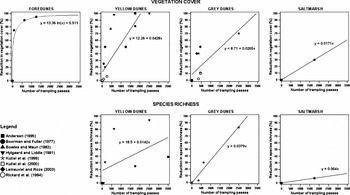
While the studies demonstrated that biodiversity declines as trampling increases, there was variation between the individual results. We plotted the results from all of the studies and fitted a regression line to ascertain the consensus relationships between trampling intensity and reductions in vegetation cover and species richness (Fig. 1). Since some habitats are more sensitive to use than others (Kutiel et al. Reference Kutiel, Zhevelev and Harrison1999), individual relationships were established for each habitat. In each case a variety of functional forms were tested and the best-fit line was fitted based on the adjusted R 2 values. When non-linear functions were tested they were often found to be inappropriate because the curves levelled out before reaching 100% reductions in vegetation cover and richness, and therefore they poorly predicted at high levels of trampling. As a solution, linear functions were fitted and these were truncated at 100% in order to prevent further reductions after bare ground had been reached. While many of the relationships were based on few data points, they suggested that saltmarsh and grey dunes may be more resilient to trampling than foredunes and yellow dunes. These relationships were used to calculate the current impact of visitors on vegetation cover and species richness at Holkham and Cley, based on the number of annual trampling passes recorded within each cell in the GIS.
Relationships between the number of trampling passes and the percentage reduction in vegetation cover and species richness, based on values cited in trampling literature (see legend for references).

Once changes in vegetation cover and species richness had been calculated, these values were adjusted to take into account natural regeneration. It was assumed that the majority of trampling passes would occur during the summer when visitor numbers are highest, and that regeneration would take place outside the main tourist season. Therefore, predicted reductions due to trampling were adjusted assuming a 95% annual regrowth of vegetation cover and a 79% regeneration of species richness, based on observed rates across sand dunes over one year (Hylgaard Reference Hylgaard1980). Few studies have examined regeneration rates after trampling and we did not find any studies which examined regeneration rates in habitats other than dunes. Therefore, the same values were used to adjust the predictions for both dunes and saltmarsh.
Although extensive research has been undertaken to produce individual level models, based on optimal foraging and game theories, that track the behavioural decisions and locations of all birds within a population (see Goss-Custard et al. Reference Goss-Custard, Triplet, Sueur and West2006; Stillman et al. Reference Stillman, West, Goss-Custard, McGrorty, Frost, Morrisey, Kenny and Drewitt2005; Durell et al. Reference Durell, Stillman, Triplet, Aulert, Bio, Bouchet, Duhamel, Mayot and Goss-Custard2005), we did not find any studies that modelled the relationship between levels of recreational use and numbers of birds present in coastal habitats in a cross-sectional manner. Therefore, to provide a measure of visitor impacts on birds, this relationship was modelled using data on the presence of ringed plover at Holkham and Cley from a recent study which examined the effect of tourists on the distribution of ringed plover and oystercatcher (Haematopus ostralegus) territories and the impacts of climate change on this interaction (Tratalos et al. Reference Tratalos, Gill, Jones, Showler, Bateman, Watkinson, Sugden and Sutherland2005).
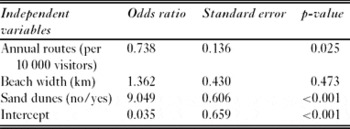
The presence or absence of ringed plover at Holkham and Cley was modelled for 100 m2 size cells using logistic regression. A 100 m resolution was used because ringed plover take flight at approximately this distance when approached by a visitor (Smit & Visser Reference Smit and Visser1993). The presence of ringed plover was modelled in relation to: (1) the number of annual visitor routes that intersected each cell as recorded during surveys (per 10 000 visitors), (2) beach width calculated in GIS from OS MasterMap data as the distance between mean low water level and the landward limit of the intertidal zone, and (3) the presence of sand dunes within the cell identified from OS MasterMap data and represented by a dummy variable (Table 1, Cox and Snell R 2 = 0.057, Nagelkerke R 2 = 0.207, p < 0.001).
Logistic regression for presence of ringed plover in relation to levels of visitor use and beach characteristics, based on observations recorded at Holkham and Cley, Norfolk.

The regression relationship was used to estimate the size of area at Holkham and Cley that is currently suitable for ringed plover by applying the model to predict the probability of a ringed plover being present within each 100 m2 cell based on present visitor use, where cells were considered suitable if they were assigned a 0.5 or greater probability of plover being present. This process was repeated until a prediction had been made for every cell within non-vegetated areas of the beach (sand, shingle and mudflats), foredunes, yellow dunes and saltmarsh. Predictions were not made for grey dunes because ringed plover do not use these areas.
Stage 3: evaluating future impacts of coastal recreation on biodiversity
To predict future impacts on biodiversity it was necessary to take into account anticipated changes in visitor numbers owing to climate change. Since the activities that visitors undertake influence the habitats they use and therefore their impact on biodiversity, changes in visitor numbers were assessed for different activity groups. This work is described in detail in Coombes (Reference Coombes2007) and is outlined briefly here. As activity groups have different preferences for environmental conditions, they are expected to respond differentially to the effects of climate change. Visitor surveys were undertaken at Holkham and Cley beaches to elicit information on the weather condition and beach preferences of a range of visitor types including walkers, bird watchers and bathers. Information on activity groups' preferences was then compared to predicted increases in temperatures and sea level, based on the UK Climate Impacts Programme (UKCIP) low and high emission scenarios for the year 2080 (Hulme et al. Reference Hulme, Jenkins, Lu, Turnpenny, Mitchell, Jones, Lowe, Murphy, Hassell, Boorman, McDonald and Hill2002), to evaluate how these changes may affect visits by each group. As expected, visitors relaxing and sunbathing are particularly sensitive to warm and dry weather conditions, and increased temperatures may result in a relative increase in bathers compared to other activity groups (Table 2).
The predicted impacts of climate change on different activity groups. The predicted changes in visitor numbers range is based on the UK Climate Impacts Programme (UKCIP) low and high emission scenarios for the year 2080 (Hulme et al. Reference Hulme, Jenkins, Lu, Turnpenny, Mitchell, Jones, Lowe, Murphy, Hassell, Boorman, McDonald and Hill2002).

The visitor routes were categorized according to respondents' primary activities, examples being dog walking, walking, bird watching, relaxing or sunbathing, and playing or paddling. Predicted future increases in beach use for each activity group (Table 2) were used to adjust the number of routes passing through each habitat, to predict the total annual visitor routes for the UKCIP low and high emissions scenarios for 2080. The UKCIP scenarios (Hulme et al. Reference Hulme, Jenkins, Lu, Turnpenny, Mitchell, Jones, Lowe, Murphy, Hassell, Boorman, McDonald and Hill2002) were developed from the Special Report on Emissions Scenarios (Intergovernmental Panel on Climate Change 2000) and represent alternative pathways for future economic, social and technical developments. Reductions in vegetation cover, species richness and presence of ringed plover were predicted for both scenarios using the relationships from Stage 2. These values were compared to those obtained for current use, to assess the impact of additional visitors and changes in visitors' activities.
In order to investigate the manner by which spatial patterns of habitat use may change under future conditions of sea level rise, the findings from the assessment of habitat use were stratified according to whether observations were made at conditions of high or low tide. High tide conditions were taken to approximate those that may be observed in a situation where beaches were not able to accommodate sea level rise by rolling back, leading to coastal squeeze occurring.
RESULTS
Current levels of visitor use within habitats
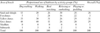
The combined results for Holkham and Cley demonstrate that visitor use was high within non-vegetated areas of sand and shingle, and that a large proportion of this use was from visitors relaxing or sunbathing and playing or paddling (Table 3). Yellow and grey dunes also experienced high levels of use, particularly from dog walkers and walkers. In contrast, few visitors used mudflats or saltmarsh.
Proportional use of habitats by different activity groups (%), based on the combined data for Holkham and Cley.

Effects of climate change on visitor impacts
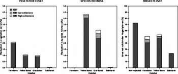
The results suggest that trampling by visitors had higher impacts on vegetation cover and species richness in dunes than on saltmarsh (Fig. 2). This is because few visitors walked over this habitat and, in addition, saltmarsh may be more resilient to trampling. Increased visitor numbers by 2080 are not predicted to result in a significant increase in impacts on vegetation biodiversity, for either the low or high emissions scenario. The findings also demonstrate that the present day presence of visitors on the beach significantly restricts the availability of habitats suitable for ringed plover, particularly within non-vegetated areas that experience high levels of use (Fig. 2). It is predicted that increased visitor numbers in the future may lead to further areas of dunes becoming unsuitable for use by ringed plover.
Predicted annual mean reductions in vegetation cover, species richness and areas suitable for ringed plover, across habitats, based on current levels of annual visitor use at Holkham and Cley, and for the UKCIP low and high emissions scenarios for 2080 (Hulme et al. Reference Hulme, Jenkins, Lu, Turnpenny, Mitchell, Jones, Lowe, Murphy, Hassell, Boorman, McDonald and Hill2002).

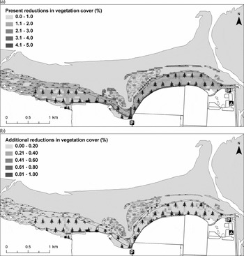
There was considerable spatial variation in current visitor impacts on vegetation cover (Fig. 3) and species richness (Fig. S2, see Supplementary material at http://www.ncl.ac.uk/icef/EC.Supplement.htm) across Holkham beach. The areas that are most vulnerable to degradation are highlighted and show that, as anticipated, impacts on vegetation were greatest close to the car park and were also high at habitat boundaries, possibly because visitors enjoy walking along the edge of habitats where they can view different environments simultaneously. Changes in recreational use by 2080 are predicted to result in greater reductions in vegetation cover and species richness, particularly at habitat boundaries, although the additional impacts are not expected to be large compared to those of the present day. It is also predicted that there will be an increase in degradation of saltmarsh as visitor use increases on these currently relatively undisturbed areas.
(a) Current visitor impacts on vegetation cover at Holkham and (b) predicted additional reductions in vegetation cover by 2080 based on predicted visitor use under the UKCIP high emissions scenario for 2080 (Hulme et al. Reference Hulme, Jenkins, Lu, Turnpenny, Mitchell, Jones, Lowe, Murphy, Hassell, Boorman, McDonald and Hill2002).

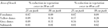
The results from the sensitivity analysis show predicted additional reductions in percentage vegetation cover across habitats for the 2080 high emissions scenario, compared to current impacts (Table 4). The size of cell over which impacts are assessed, and the width of path that is assumed, influence the predicted values. The range of predicted values is greatest for the yellow and grey dunes. This is because a larger cell size reduces the impact of visitors' inaccuracies in route drawing and also incorporates more routes within the cell, thus increasing the amount of disturbance predicted. This will be particularly noticeable in areas of high use such as the yellow and grey dunes. Nevertheless, the differences between the predicted additional reductions in vegetation cover are small compared to the present day reductions. Furthermore, the relative differences between the habitats are similar regardless of cell size and path width, with yellow and grey dunes expected to see the greatest increase in impacts.
Predicted additional reductions in the % vegetation cover for the 2080 high emissions scenario (Hulme et al. Reference Hulme, Jenkins, Lu, Turnpenny, Mitchell, Jones, Lowe, Murphy, Hassell, Boorman, McDonald and Hill2002) relative to current impacts, where changes were estimated based on different cell sizes and path widths.

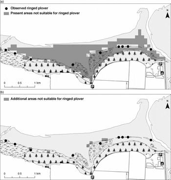
Many visitors at Holkham presently walk across non-vegetated areas of beach, restricting plover to peripheral areas away from the main entrance (Fig. 4). The maps show a good match between the current location of plover nests and the area predicted as suitable from the model, although plover were present within some areas that were classified as unsuitable. This limitation of the model may be a result of the fact that some birds may adapt to higher levels of use in order to occupy areas that are of a high quality in other habitat characteristics. The model shows that future increases in visitor use are predicted to result in further losses of suitable areas. Notably, some areas of dunes that ringed plover currently use are predicted to become unsuitable by 2080 (Fig. 4).
(a) The distribution of ringed plover territories at Holkham and current visitor impacts on the suitability of areas for ringed plover and (b) predicted additional reductions in areas suitable for ringed plover by 2080 based on predicted visitor use under the UKCIP high emissions scenario for 2080 (Hulme et al. Reference Hulme, Jenkins, Lu, Turnpenny, Mitchell, Jones, Lowe, Murphy, Hassell, Boorman, McDonald and Hill2002).

At Cley beach, the majority of routes sampled were within areas of shingle (Fig. S3, see Supplementary material at http://www.ncl.ac.uk/icef/EC.Supplement.htm). It was possible for visitors to avoid vegetated habitats at Cley because it was not necessary to cross these areas to access the beach from the main entrance. Only a few routes were recorded in saltmarsh and these were within a small area, covering only two cells. Saltmarsh is relatively resistant to trampling and the levels of trampling observed were not sufficient to result in reductions in cover or richness. Therefore, spatial variations in vegetation cover and richness are not mapped for this site. In contrast, a large area was classified as unsuitable for ringed plover because of the presence of visitors (Fig. S4, see Supplementary material at http://www.ncl.ac.uk/icef/EC.Supplement.htm). The map demonstrates that plover territories were currently restricted to the back of the beach where few visitors walk. However, it is predicted that increased visitor numbers at Cley may not further restrict suitability because visitors to this site mostly use areas of shingle.
To examine how visitor use at Holkham and Cley may change under future sea level rise, the percentage of cells of each habitat type that were used by visitors at the two sites, were stratified according to low and high tide conditions (Table 5). The data for high tide provides an indication of how spatial patterns of beach use may change if future sea level rise leads to coastal squeeze at the sites. There was a statistically significant difference in use patterns between the two tidal conditions (p < 0.001). All types of dune and the saltmarsh habitats were more frequently visited at high tide (Table 5), suggesting that these habitats may come under additional pressure under future sea level rise conditions.
Percentage of habitat cells used by visitors under conditions of low and high tide.

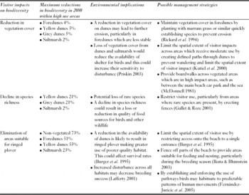
To identify the areas where biodiversity is most likely to be affected by changes in recreational use owing to climate change, predicted reductions in biodiversity were calculated for areas within each habitat that are expected to experience the greatest levels of use in 2080 (Table 6). Maximum reductions in biodiversity were estimated by identifying the cell in each habitat that is predicted to experience the greatest number of visitor passes in 2080 and calculating the expected reductions in vegetation cover and species richness. Elimination of areas suitable for ringed plover were summarized according to the percentage of cells within each habitat that are predicted to be unsuitable. The environmental implications of these changes and possible response management strategies were evaluated (Table 6). Measures that limit the spatial extent of visitor impacts, such as restricting access to a single entrance point (Burger et al. Reference Burger, Gochfeld and Niles1995), creating defined paths through habitats to limit wandering (Rickard et al. Reference Rickard, McLachlan and Kerley1994; Kutiel et al. Reference Kutiel, Eden and Zhevelev2000) and preventing access to sensitive areas that contain rare plant species or nesting birds (Gallet & Roze Reference Gallet and Roze2001; Ikuta & Blumstein Reference Ikuta and Blumstein2003), may help to minimize reductions in biodiversity.
Summary of predicted reductions in biodiversity calculated for areas within each habitat that are expected to experience the greatest levels of use in 2080, the potential environmental implications of these impacts and possible management strategies.

DISCUSSION
This study examined the biodiversity implications of modifications to coastal recreation at Holkham and Cley beaches owing to climate change. Although changes to beach recreation are likely to slightly increase the loss and diversity of vegetation in coastal habitats, these effects are not predicted to be large overall. It is, however, likely that habitats will experience differential impacts, with dunes and areas that are close to entrances or at the boundaries between habitats expected to see the greatest change. Whilst additional reductions in vegetation biodiversity may be relatively small, increased visitor numbers may significantly affect ringed plover, which are already restricted to peripheral parts of the beach, by eliminating further areas of suitable habitat. It is interesting to note that although significantly greater visitor numbers are predicted under the high, compared to the low, emissions scenario, there is only a small difference between the predicted reductions in biodiversity.
Although increased visitor use is not predicted to result in a considerable overall decrease in vegetation cover and species richness compared to current levels of degradation, there are likely to be differences in the intensity of impacts experienced between habitats. As anticipated, the lower levels of trampling observed in saltmarsh protect it from the reductions in diversity seen in dunes. Use may be higher within dunes as visitors often need to cross these areas to reach the beach and also because they may prefer this habitat. In addition, the spatial extent of trampling within saltmarsh may be limited by tidal creeks, which can be difficult to walk across.
Whilst regeneration of vegetation cover and richness occurs outside the peak tourist season, habitats often do not completely recover from the impacts of a single season and so trampling damage may accumulate over a number of years. Consequently, a relatively small increase in use could have significant impacts on coastal environments. Furthermore, although regeneration rates of vegetation cover can be high, species richness shows slower recovery because trampled areas may be recolonized by invasive species. Therefore, although environmental degradation resulting from trampling may not always be visible as habitats are often able to maintain a relatively high level of vegetation cover, losses in species diversity may occur.
Ringed plover are currently restricted to relatively small areas of dunes and these areas are predicted to decline in suitability as a consequence of increased recreational use. Greater visitor numbers are also likely to increase levels of noise, which may further disturb shorebirds even if visitors do not directly pass through areas where plover are present. In addition, losses of vegetation from dunes and saltmarsh due to greater levels of trampling could reduce the availability of cover and shelter for ringed plover and increase their sensitivity to disturbance. As plover become constrained to smaller areas this is likely to increase competition for territories and may result in them making greater use of habitats that are less suitable, which could in turn lead to a decline in breeding success.
The additional visitor impacts that coastal environments experience may be compounded by habitats being more sensitive to disturbance as they respond to climate change and sea level rise. Firstly, at locations that experience a reduction in beach width there will be a smaller area available for recreational use, thus increasing pressure on remaining habitats, particularly when combined with increased visitor numbers. In addition, loss of beach could result in visitors making greater use of vegetated habitats such as dunes at the back of beach. If future sea level rise results in coastal squeeze, our findings suggest that the dune habitats and saltmarshes may experience increased disturbance as visitors are forced to use them as a result of reductions in the area of foreshore. Given these are the parts of the beach that are of highest biodiversity value, this is of concern.
Secondly, changes to the structure of beaches may further restrict the suitability of areas for shorebirds (Durell et al. Reference Durell, Stillman, Caldow, McGrorty, West and Humphreys2006). Notably, ringed plover prefer wide beaches with sand dunes, and these types of beaches may be particularly affected by sea level rise which could reduce their availability. Since visitors also have a preference for wide sandy beaches (Tudor & Williams Reference Tudor and Williams2006), a loss of these areas could result in greater interactions between visitors and ringed plover at remaining suitable areas, resulting in increased disturbance. Thirdly, greater storminess may encourage erosion of dunes (Brown & McLachlan Reference Brown and McLachlan2002), particularly the more exposed foredunes, and this could make them more vulnerable if, for example, eroded areas are walked over and form part of a permanent path. Finally, higher temperatures and drier conditions during the summer are likely to increase stress on vegetation so that it is more susceptible to damage by trampling and has a lower capacity to naturally regenerate (Gallet & Roze Reference Gallet and Roze2001). Management strategies which limit the spatial extent of visitor impacts, such as beach zoning, may help to minimize any reductions in biodiversity that accompany changes in recreation.
The findings from this research are presented with several caveats. An important limitation was that it was not possible to model changes in beach structure at Holkham and Cley. For example, it was not possible within this study to consider how sea level rise may impact beach accretion and erosion patterns. There are considerable uncertainties regarding which processes may predominate and what their implications may be on different sections of the coast. Although the application of the Bruun effect (Bruun Reference Bruun1962), where the initial effect is assumed to be inundation but eventually enough material will be deposited offshore to re-establish the beach profile at a higher elevation, is commonly advocated, Stive (Reference Stive2004) argued that it may not predominate in many situations. Unfortunately, a more dynamic modelling exercise was beyond the scope of this research, as the data were not available to undertake it a way that would provide a suitable level of confidence in the results. The Coastal Habitat Management Plan (CHaMP) for North Norfolk aims to allow habitats to roll landwards in response to sea level rise in the medium term (the next 50 years) at Holkham and to retreat existing lines of defence at Cley (English Nature & Environment Agency 2003) and, if this is so, there may not be a significant reduction in beach width at either location. Nevertheless, it may be that roll back does not occur, and hence we examined how patterns of visitor use differed between high and low tidal conditions. If coastal squeeze occurs, the results of our analysis of high tide conditions provide some insight as to how spatial patterns of beach use may change.
To refine predictions of future visitor impacts, further work should focus on developing methodologies that model how routes may be affected by sea level rise and habitat changes, including new habitat created by management practices such as managed realignment. Although routes were drawn in relation to current tide levels in this work, a possible means to achieve this might be to examine how they vary with different tidal levels to provide an insight into how visitors may respond to sea level rise.
While natural regeneration of vegetation was taken into account in this study, the rates of recovery were assumed to be the same for all habitats, and we assumed that regeneration rates would not be affected by climate conditions. Since the composition of species varies between the habitats, and they respond differently to visitor use, it is likely that their rates of regeneration may vary. As we did not have data on the actual distribution of individual plant species, we were not able to differentiate how trampling may have a differential effect on them. Although our findings do provide a robust indication of how overall vegetation cover may be affected, from a conservation perspective disturbance to rare species will be more serious than to those that are abundant. It may also be that climate conditions will influence rates of regeneration; for example, anticipated warmer conditions could increase the length of the growing season and encourage regeneration, particularly in the autumn after increased summer disturbance, but this effect may be attenuated if rainfall decreases. In addition, predicted reductions in biodiversity were calculated based on annual visitor use and although they allow impacts to be compared between years, they do not take into account accumulative impacts over consecutive years. Predictions of net impacts over several years could be developed by using habitat specific regeneration rates.
This study has focused on the immediate beach environment. However, there are likely to be implications of the predicted changes in visitor numbers that will operate at a much wider scale. Our climate change scenarios incorporate a consideration of socioeconomic pathways, but trends such as overall tourism displacement within the UK and between the UK and other countries, plus modifications in levels of government regulation via carbon taxation on travel were not explicitly quantified. While the climate of the UK means that it is unlikely to become too warm for beach use in the future, increasing temperatures in already hot countries may have the effect of displacing visitors to more temperate climates, such as that experienced at the case study sites. If so, our results may underestimate future increases in beach use. These factors may all be important and, although their quantification was beyond the scope of this work, they should be addressed in future research.
There is uncertainty regarding the exact relationships between visitor numbers and losses of biodiversity. It was difficult to generalize trampling relationships across the literature as there is a paucity of studies that have quantified visitor impacts and additionally there are differences between the trampling relationships observed. This is particularly marked for species richness within yellow dunes, for which some studies found a linear relationship (see Andersen Reference Andersen1995) and some a curvilinear relationship (see Hylgaard & Liddle Reference Hylgaard and Liddle1981). There was also considerable variation between the studies for predicted vegetation degradation at high levels of trampling, which made it difficult to accurately describe the consensus relationships. Notably, when non-linear functions were tested, single data points were often found to have a high degree of leverage on the curve resulting in poor predictions, particularly for high levels of trampling. As a solution, linear functions that were truncated at 100% were fitted, as these provided stronger models of the trampling relationships. Similarly, there is uncertainty regarding visitor impacts on bird numbers. Modelling ringed plover numbers in relation to visitor numbers across a longer stretch of coastline may improve understanding of this relationship. Nevertheless, although actual reductions in biodiversity may differ from the values presented, the results demonstrate the types of areas that may be most at risk from increased use. A final limitation was that it was not possible to account for differential impacts between activity groups. For example, visitors walking with a dog may have a greater impact on birds than those who walk alone (Lafferty Reference Lafferty2001).
Although we focused on the biodiversity implications of changes in coastal recreation at two beaches in Norfolk, the types of impacts identified are relevant to other locations that experience an increase in visitor numbers. While it is not expected that greater visitor numbers will significantly affect vegetation, there is predicted to be a considerable decrease in availability of areas suitable for shorebirds such as ringed plover. Notably, soft coastlines with wide sandy beaches which are preferred by both plover and tourists, and in addition are most susceptible to sea level rise, will be particularly vulnerable to changes in recreation due to climate change.
ACKNOWLEDGEMENTS
This research was funded by an Economic and Social Research Council and Natural Environment Research Council Interdisciplinary Ph.D. Studentship. We thank Dr Jenny Gill at the University of East Anglia for providing advice on the ringed plover modelling.