

In the spring of 1965, as the British government prepared its national plan, the route to economic prosperity seemed obvious enough to Professor Cyril Northcote-Parkinson. In a world after empire, Parkinson suggested, why should the world's first urban nation not specialize in the export of cities? Addressing the annual conference of the National Federation of Buildings Trades Employers, Parkinson proposed that British companies send houses, flats, and shops throughout the developing world. Such a plan would require these companies to develop considerable technical expertise, but that could be gained by building a new British city entirely from scratch. Parkinson proceeded to offer a fantastic vision of a city constructed on three horizontal planes, with commercial traffic below, passenger cars in the middle, and pedestrians above; tall buildings in the centre would be connected by bridges at the thirteenth floors, all overlooking a picturesque lake. Visiting tourists, struck by the achievement, would wonder what a nation capable of engineering such a feat might be able to offer their own countries, ensuring that the export of urbanism would offer Britain both domestic prosperity and international standing. The first step, however, was to build such a city within Britain itself: ‘[A] new city’, Parkinson declared, ‘newer than Brasília, better planned than New York, more convenient than Paris, would do more for British prestige than a score of misguided missiles or a dozen failures to reach the moon.’Footnote 1
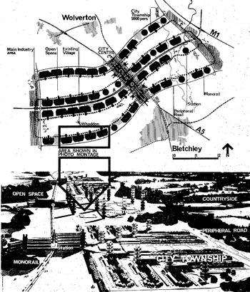
‘Prof. Parkinson wants a “British Brasília” ’, announced The Daily Telegraph. The headline caught the eye of Buckinghamshire county's architect and planner, Fred Pooley, who wrote forthwith to Parkinson: ‘I wonder if you would be interested in the work we have been doing on the North Bucks New City project.’Footnote 2 For three years, Pooley's office had been designing a city for 250,000 people between Bletchley and Wolverton. This ‘North Bucks New City’ was to consist of fifty ‘townships’ or ‘villages’ of 5,000 persons, arranged – as Figure 1 shows – around four circuits that together took the shape of a dragonfly's wings. The middle of each circuit would contain parks, schools, and sports arenas, the outer edges would house light industry such as paper manufacturing, and the pedestrianized centre would include facilities for shopping and entertainment – available year-round, thanks to an underground heating system. The city's boldest innovation, however, was its system of transport: a railway would run through the city, the M1 motorway would skirt along its eastern edge, and smaller roads would circle it, but transport inside the city would be handled by a quiet, automated, high-speed monorail. The monorail would be paid for out of local rates, and thus free at the point of service, and no home would be more than seven minutes from a station. The system would employ the latest surveillance technologies, enabling a single command station to track its cars, monitor its stations, and communicate with its staff.Footnote 3 Clean, safe monorails would thus whiz through the city – and even through its buildings – on a track ‘slung way above the people’, atop a network of mesh ready to catch any suicidal jumpers in ‘a resilient wire hammock’.Footnote 4 When one admiring journalist called the plan a ‘city for the 70s’, Pooley responded that he preferred to think of it as a ‘city for the 90s in the 70s’.
Two views of North Bucks New City: first, a map showing the layout of the townships around four monorail loops; second, a model depicting several townships, with monorail stations along the left. Reproduced by permission of the Centre for Buckinghamshire Studies.

North Bucks New City represents one iteration of the larger phenomenon of imagining the urban future during the 1960s.Footnote 5 The transatlantic pedigree of this tradition already included such landmarks as Ebenezer Howard's To-morrow: a peaceful path to real reform (1898), Corbusier's Vers une architecture (1923), Frank Lloyd Wright's ‘Broadacre City’ (begun 1924), Fritz Lang's Metropolis (1927, which opened with a shot of a monorail), and the Modern Architectural Research Group's (MARS) ‘Plan for London’ (1942).Footnote 6 These visions ranged from the idealistic to the dystopian, until the New Towns Act of 1946 offered British planners and architects the opportunity to turn designs into realities. The British state established fourteen new towns between 1946 and 1950, but the relatively modest designs of these initial efforts, which featured neighbourhood units and vernacular styles, disappointed the ambitions of more avant-garde architects and planners.Footnote 7 During the 1950s, Conservative governments established only one new town, preferring to expand existing cities instead, until the end of that decade when a surge in the birthrate contributed to a renewed round of new town development. Between 1961 and 1970, the number of British new towns nearly doubled, and this second generation of new towns saw significant departures in conception and construction. New towns of the 1960s featured higher population densities and modern shopping centres, but their most dramatic innovations resulted from the recent increase in private car ownership. Planners experimented with a variety of ways that cities might accommodate the car without succumbing to congestion, from highways in Cumbernauld (1955) to busways in Runcorn (1964) – and even, in initial designs, a hovercraft in Washington (1964).Footnote 8 It was in this context – of more ambitious new town development, and more experimental transport design – that Pooley persuaded Buckinghamshire council to build a monorail metropolis in the county's rural north.
A key historiographical distinction separates imagined visions, such as Broadacre City or the MARS plan for London, from realized projects, such as Cumbernauld or Runcorn, which perhaps explains why historians tend to pass rapidly over North Bucks New City en route to its actually built successor, Milton Keynes.Footnote 9 There is no question that Milton Keynes warrants the attention: designated in 1967, Milton Keynes soon emerged as England's fastest-growing city and Britain's largest new town.Footnote 10 Thus Frank Markham's two-volume local history, A history of Milton Keynes and district, concludes with the establishment of Milton Keynes, but does not mention either Pooley or his plan.Footnote 11 Mark Clapson's excellent Social history of Milton Keynes does discuss ‘Pooleyville’ (as North Bucks New City came to be called), but his emphasis upon, and sympathy towards, the built city of Milton Keynes inclines him to depict Pooleyville as an obstacle thankfully avoided.Footnote 12 Terence Bendixson offers kind words for Pooley, but his magnanimity leads him to stress the continuity between North Bucks New City and Milton Keynes, rather than conveying the distinctiveness of Pooley's vision.Footnote 13 In his otherwise insightful account of Milton Keynes, Andy Beckett goes one step further, reducing North Bucks New City to ‘the monorail Milton Keynes’.Footnote 14 But the most dismissive verdict has come from the planners of Milton Keynes themselves. In a roundtable discussion in 1995, while acknowledging the allure of Pooley's plan, the alumni of Milton Keynes Development Corporation recalled their co-ordinated ‘destruction’ of North Bucks New City, which persisted until Pooley finally acquiesced in the demise of his own proposal. ‘So that’, concluded Walter Bor, partner of the planning firm, ‘was the story about Pooley.’Footnote 15
That was one story about Pooley, but it was not the whole story. Rather than rushing towards Milton Keynes, this article lingers in North Bucks New City, because there is much to be learned from cities that were never built. Not only about how the future was imagined, but also how the present was managed: opportunities that beckoned, obstacles that threatened, and strategies available to deal with them both. From January 1962, when Pooley's office published its first report, until May 1965, when the county council shelved the scheme for lack of funding, Buckinghamshire proceeded with plans to build its monorail metropolis – and as late as October 1968, more than a year-and-a-half after the ministry of housing had officially designated Milton Keynes, Pooley maintained hope that something like his city might yet be built. For more than three years, he and his team – most notably his brilliant and indefatigable lieutenant, Bill Berrett – identified a site for their city, built models of its monorail and townships, commissioned transport feasibility studies, visiting working monorails abroad, fielded scores of international inquiries, negotiated (successfully) with local councils and (less successfully) with the ministry, and conducted more than a hundred public and private meetings. These efforts coincided with a frenetic period in British urban planning, as hundreds of proposals for the ‘comprehensive redevelopment’ of town and city centres flooded the ministry of housing and local government.Footnote 16 The future, it seemed, was being forged in Britain's cities, and few councils wanted to be left behind. The enthusiasm crested by the end of the decade, but not before making an enormous impact upon the nation's urban landscape: according to the historian John Gold, ‘[I]t was during these few years that the urban fabric changed more dramatically than almost any comparable period in British history.’Footnote 17 Working at precisely this moment and in exactly this context, Pooley may not have built a city, but he did produce an archive – and that archive offers an invaluable lens through which to examine the assumptions and ambitions that flourished spectacularly, only to recede rapidly, during this pivotal moment in Britain's long urban history.Footnote 18
I
Whitehall did not make the plans, but it did make them possible. By the early 1960s, London's population was poised to swamp Buckinghamshire, just as increasing car ownership threatened to overwhelm the county's towns and villages. But if population pressures had increased, so, too, had the resources available to manage them: the first part of the M1 opened in 1959, and would soon link north Bucks to London, while the River Ouse was permitted to expand after 1961, increasing the region's access to drainage and water.Footnote 19 The British state's most powerful technology of population management, however, remained the New Towns Act of 1946, which Whitehall had already employed to establish sixteen new towns throughout England, Scotland, and Wales by 1962.Footnote 20 The British programme had parallels in a number of countries during the post-war period, as states inside and outside Europe – including, but not limited to, France, West Germany, Sweden, the Netherlands, the Soviet Union, Brazil, Venezuela, Nigeria, Egypt, and India – built new towns in order to redistribute populations, steer economic development, or establish new capitals.Footnote 21 Of the British projects, Basildon and Peterlee resulted from local petitioning, and London county council planned a new town called Hook that was never actually built, but in general the new towns were national efforts, and in fact no local authority had successfully developed a new town of its own.Footnote 22 It was thus an audacious move when, in January 1962, Buckinghamshire county council's departments of architecture and planning published the first in a series of reports exploring the possibility of a new city in north Buckinghamshire. Mindful of the problems posed by population and congestion, that report fastened on the idea of a monorail city for 250,000 residents. During the next two years, working quietly behind the scenes, Pooley and his office developed the plan for North Bucks New City.Footnote 23
Originally from London's east end, Frederick Bernard Pooley qualified as an architect, planner, and surveyor before the Second World War.Footnote 24 During the war, he served with the royal engineers, and afterwards he worked as a deputy architect and planner in the rebuilding, first, of West Ham, and then of Coventry. In 1953 he became Buckinghamshire's chief architect, and in 1961 he added the post of county planning officer as well.Footnote 25 He collected a CBE for services to architecture in 1968, before moving to the greater London council in 1974, by which time he was also serving as president of the Royal Institute of British Architects. Pooley's aesthetic was contemporary, but not avant-garde, and the difficulty of characterizing his work complicates accounts that would divide post-war architecture between ‘modernism’ and its critics. ‘Determinedly traditionalist’ to some, ‘one of the most inventive architects of his time’ to others, Pooley sparred with ‘preservationists’ but called himself a ‘conservationist’.Footnote 26 The distinction was subtle, but revealing: ‘preservation’, for Pooley, implied halting development, but ‘conservation’ meant guiding it. ‘We should look after the best that we have inherited’, he maintained, but he also believed that new projects ‘should be of our times’. So while he became known for his dislike of large concrete projects, and for his preference for vernacular styles, in both Coventry and Aylesbury Pooley worked with the typically modern media of concrete and towers. His most notorious project, for example, was the headquarters he designed for Buckingamshire county council, a concrete tower erected in 1966 that the architectural critic (and Pooley's friend) Ian Nairn memorably branded ‘Fred's fort’ – but which locals still refer to as ‘Pooley's folly’.Footnote 27 Yet that tower stands in contrast to much of Pooley's work, with its commitment – even during the brutalist 1960s – to ‘homes-on-the-ground’ featuring brickwork and pitched roofs. So if the label ‘modernist’ does not quite fit, it is less because Pooley was not ‘modern’ than because his pragmatic style resists categorization within so programmatic a vision. Personally, Pooley's manner was affable and winning: far from the ‘monster’ depicted by preservation societies, Bendixson describes him as ‘a purring, tweedy, aitch-dropping teddy-bear of a man’, and his correspondence reveals a surfeit of good humour without an ounce of pretension.Footnote 28 But that agreeable manner concealed a bold imagination and a keen knack for politics, qualities that served him well when opportunity presented itself in the early 1960s.
The British state had long been concerned with the distribution of its population, particularly its concentration in and around London.Footnote 29 In 1937, the government appointed a royal commission to study the matter; three years later, the Barlow report on the ‘distribution of the industrial population’ identified a worrisome concentration of population in the home counties.Footnote 30 The concerns were economic, but also strategic, and the experience of wartime bombing only made them more pressing.Footnote 31 Barlow recommended development around London to facilitate the dispersal of its population, and in 1944 Patrick Abercrombie endorsed that recommendation in his Greater London plan.Footnote 32 Barlow and Abercrombie inspired two of the most important planning acts in twentieth-century British history: the New Towns Act of 1946, which established mechanisms placing urban development under the central government's control, and the Town and Country Planning Act of 1947, which (among many other things) required local councils to clear their development plans with Whitehall.Footnote 33 Between 1946 and 1950, six of the fourteen new towns the Labour government designated were intended to relieve pressure upon London.Footnote 34 But even such aggressive action could not alter the fact that, in 1951, Britain was already one of the most densely populated countries on the planet, and during the next two decades that density only increased.Footnote 35
By the early 1960s, due to a rising birthrate and commonwealth immigration, these longstanding concerns about the distribution of population were joined by fresh concerns about its growth.Footnote 36 In line with major European cities from Barcelona to Belgrade, London's growth during this period was especially pronounced.Footnote 37 In 1961, the government appointed a commission to study population dynamics in and around the capital, and three years later the South East study found enormous population pressures upon London and its environs.Footnote 38 There were 18,000,000 people who lived in the triangle between Dover, Weymouth, and the Wash, 35 per cent of the country's entire population. That number had increased by 3,000,000 since the 1930s, and was projected to rise by another 3,500,000 by the 1980s. London's growth had especially shattered expectations, to the point that, according to the report, the capital seemed ‘in danger of choking’. The study identified three ways forward: do nothing, continue with existing plans, or reconfigure the entire region's population. Endorsing this third – and most radical – option, the South East study called for an expansion of the new towns programme. It recommended building on sites more remote from London, with an eventual target of housing an additional 1,250,000 people, and specifically mentioned the possibility of expanding in north Bucks.
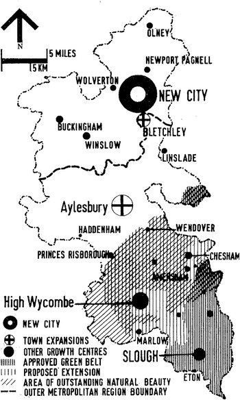
The South East study provided a timely boost to thinking already underway at Buckinghamshire county council. Since 1954, the county's development had been guided by a plan with the ministry of housing and local government's approval, as required by the Town and Country Planning Act. A review of that plan was due in 1959, but Pooley already believed more thorough action was required. During the next few years, working with the county clerk, R. E. Millard, and the chairs of three committees (Ralph Verney in finance, S. T. Ireland in works, and S. A. Comben in planning), Pooley and Berrett produced a series of documents.Footnote 39 The first was published in January 1962: ‘The overspill problem in Buckinghamshire – a new city?’ identified the problem and proposed a solution.Footnote 40 London's growth, it explained, threatened to overwhelm the southern third of the county, which the council had therefore already declared a greenbelt, while the centre of the county was close enough to London that expansion might render it a mere satellite of the capital. North Bucks, however, remained largely undeveloped, partly because a water shortage had blocked expansion in the late 1940s. The Great Ouse Water Act of 1961 resolved that situation, enabling the planners to consider a new city between Wolverton and Bletchley.Footnote 41Figure 2 shows the city's proposed location in the county's north (almost precisely the area that is today home to Milton Keynes), and indicates its prospective utility in drawing population away from the greenbelt in the south. Such a city, the authors suggested, could help the region cope not only with the overflow from London, but also with immigration from the commonwealth.Footnote 42 The density, growth, and shifts of population thus posed problems on a number of levels – inside Buckinghamshire, around London, throughout England, and within the commonwealth – and a new city in north Bucks promised to address them all at a stroke.
Map of Buckinghamshire, showing the greenbelt bordering London in the south, and the new city's location between Wolverton and Bletchley in the north. Reprinted from Fred Pooley, North Bucks New City (Aylesbury, 1966), p. 9, by permission of the Centre for Buckinghamshire Studies.

While population pressures could be alleviated by building a new city, mounting concerns about traffic congestion required innovations in the urban form. North Bucks New City was being planned at a pivotal moment in the history of transport. The number of motor vehicles in Britain doubled between 1950 and 1960, from nearly 4,500,000 to more than 9,000,000, so that by the early 1960s it was common to refer to the nation as a ‘car-owning democracy’.Footnote 43 The impact of these changes upon the daily lives of millions is difficult to overstate. Consider, for example, the seemingly mundane matter of getting to and from work. In the 1940s and 1950s, the three means by which men most often commuted were bicycle, train, and bus, with cars and vans fourth. During the 1960s and 1970s, however, journeys by car and van surged comfortably into the lead, accounting for nearly as many commutes as every other mode combined. The numbers among women were even more striking: in the 1940s and 1950s, of eight means of commuting, cars and vans came in seventh (ahead only of motorcycles); whereas by the 1960s and 1970s, cars and vans were the most common means of women's commutes, accounting for nearly one in three trips.Footnote 44 Personal affluence played a part in this shift, but so too did the state, as the ministry of transport built a thousand miles of motorway between 1962 and 1972 – more than a mile per week, every week, for a decade.Footnote 45
This triumph of the car posed challenges for towns and cities, and it was in this context that Colin Buchanan's committee published its landmark Traffic in towns. Commissioned by the ministry of transport, this unlikely bestseller – with the unpromising subtitle, A study of the long term problems of traffic in urban areas – depicted a nation at a crossroads. Britain boasted higher rates of car ownership than any other European country, but lacked the motorway infrastructure of Germany or the United States.Footnote 46 ‘The problems of traffic are crowding in upon us with desperate urgency’, Buchanan wrote, to the point that clogged roads threatened ‘general thrombosis’ – especially in the south-east.Footnote 47 Congestion and accidents presented challenges, but the car's greatest threat lay in its impact upon Britain's cities.Footnote 48 Traffic seemed poised to overwhelm town and city centres, most of which had developed before cars existed. An effective response must be neither piecemeal nor uncoordinated: indeed, the report insisted, it demanded nothing less than the reconceptualization of the city.Footnote 49 ‘It is clear that any attempt to implement these ideas would result in a gigantic programme of urban reconstruction’, read the preface. ‘We see no reason to be frightened of this.’Footnote 50 Such reconstruction might take the form of physical segregation, with traffic and pedestrians separated on distinct planes, but, above all, it required that ‘freedom’ be understood as something more than the freedom to drive where one pleased.Footnote 51 Planners thus found themselves in an unenviable position, certain to be criticized for either action or inaction, even as the fate of Britain's cities lay squarely in their hands.Footnote 52
Traffic in towns confronted the very challenge that bedevilled Pooley and his colleagues: how to plan a city for the car, when the car threatened the city?Footnote 53 This problem loomed over the planning of new towns at the time, and Pooley himself had been grappling with it since his time in Coventry after the war – where, in the very heart of Britain's motor city, he had helped establish the country's first pedestrian centre.Footnote 54 By the early 1960s, the conflict between car and city was only more pressing: in the urgent language of the Buckinghamshire planners, ‘The motor car will destroy a human environment and inhibit civilised living if allowed complete freedom.’Footnote 55 Pooley put the paradox this way: people wanted cars because they provided access to the benefits afforded by affluence (for instance, shopping and entertainment), but the provision of those benefits required concentrations of population that produced gridlock in cities. Later in the decade, the ‘dispersal’ of population and services would emerge as a fashionable solution to this problem, best exemplified by the architectural critic Reyner Banham's paean to Los Angeles.Footnote 56 But this revisionist redemption of American sprawl was not yet mainstream when North Bucks New City was being planned and, in fact, Pooley invoked the spectre of Los Angeles to discredit the prospect of dispersal. If planners remained committed to dense city centres, he maintained, they had no choice but to identify alternatives to the car.Footnote 57 On at least one occasion, Pooley confessed to finding inspiration in the slogan ‘defeat the motor car’, but generally that sort of antagonism was not his style.Footnote 58 Instead, the monorail in North Bucks New City – like the pedestrian centre in Coventry – should be understood not as a rejection of the car, but as a response to its success: it was the automobile's triumph that required a re-imagined city.Footnote 59
In September 1962, the monorail made its debut in a second report on the possibility of a new city for north Bucks. Pooley had asked Berrett to consider the implications of a new city of 250,000 people; he then left for a holiday in Scotland, and during the next fortnight Berrett produced a document that became the foundation of subsequent planning.Footnote 60 A city for 250,000 residents, that September report stated, could not realistically be planned assuming complete motor car use. Some form of public transportation was therefore essential, and monorail loops offered the added benefit of leaving ample space in their centres.Footnote 61 A third report in December developed these ideas further: ‘townships’ or ‘villages’ of 5,000–7,000 people would be developed along monorail circuits like ‘beads on a string’, with each township's monorail station including amenities such as schools, shops, and clinics. The ‘beads’ (or townships) would be distributed along the ‘string’ (the monorail), so future development could be accommodated by adding more strings of beads. Since the villages were to be situated outside the monorail lines, no neighbourhood would be divided by its tracks, and the areas inside the tracks would leave space for parks, sporting grounds, and other amenities. Each home would have a garage, as well as access to roads, but intra-city travel would emphasize the monorail, funded out of local rates and thus free of ticketing.Footnote 62 The city would be large, but built to human scale: in addition to each home's proximity to a station, no station would be further than a fifteen-minute journey to the centre. Children could cross safely beneath the tracks without dodging traffic, while elevated footpaths in the city centre would separate pedestrians from traffic below.Footnote 63 One study concluded that these precautions, coupled with automated fail-safe features, would curtail the risk of injury, while the system as a whole would save more than seven million miles of car journeys per year.Footnote 64
These ideas were fantastic, even futuristic, but they were by no means otherworldly or especially eccentric. Traffic in towns similarly endorsed the segregation of pedestrians from traffic, and that proposal also featured in Professor Northcote's address in Edinburgh. The commitments to technology (in the monorail), linearity (along its circuits), expandability (through the addition of subsequent loops), and leisure and consumption (discussed in the next section) were all typical of British planning during these busy years of urban redevelopment.Footnote 65 And the plan was positively hard-headed by comparison with the true avant-garde in British architecture at the time, its proposal to manage future growth by appending additional monorail loops only a faint (and unwitting) echo of Archigram's playful ‘plug-in city’ of mobile pods for living. Indeed, Archigram's experimental schemes had more in common with the ‘spatial urbanists’ in France and the Metabolists in Japan than the departments of architecture and planning at Buckinghamshire county council.Footnote 66 The alluring drawings that Berrett produced, which depicted residents walking amid low-slung modern buildings, were more in tune with the ‘townscape’ aesthetic associated with the Architectural Review, while Berrett's models of residential villages, which featured soaring towers alongside homes-on-the-ground, developed a domestic engagement with international design trends that was by then well established.Footnote 67
As for the monorail, while it promised to take Britain into the future, its advocates were quick to note that it boasted a long and proven history. The county's feasibility study cited the Wupper Valley line in West Germany, which had safely carried 950,000,000 passengers since opening in 1901.Footnote 68The Observer ran a feature on the German monorail in 1961, urging British investment in similar technology to keep pace internationally, while Pooley was monitoring ongoing efforts to build monorails in Paris and Tokyo.Footnote 69 A monorail featured in the Leicester traffic plan of 1964, and in the design for Washington new town the same year, while the Buchanan report praised monorails amid a discussion of future transit possibilities that included hovercrafts, travelators, chair-lifts, and jetpacks.Footnote 70 Another book, New movement in cities, set North Bucks New City in an international context, discussing the British project alongside parallel efforts to develop carveyors, minirails, and gondola cars.Footnote 71 These possibilities were part of a range of ideas that flourished as the motorways advanced. That is, rather than obviating conversations about novel transport possibilities, the automobile's ascendance stimulated wide-ranging discussions about public transport's new look. In the context of these discussions, while (as we shall see) the monorail's critics eventually carried the day, its boosters argued their case based not only on novelty, but also on cost. Elevated tracks, they noted, were more affordable than underground tunnels, while developments in computers and automation promised further savings by eliminating the need for drivers, ticketing, and traffic controls. Taking these factors into consideration, the feasibility study optimistically concluded that the monorail would ultimately cost less than half of a bus network.Footnote 72 So while the monorail was certainly a thrilling prospect – as one booster put it, ‘Transport should have delight’ – in the eyes of its advocates it was also a pragmatic one: this ‘futuristic’ technology, they maintained, represented a tested and affordable option amid a range of possibilities for public transport in the automotive age.Footnote 73
By the end of 1963, it was time to go public. For two years, Pooley's office had been developing its proposal. They were working, as seen, against the backdrop of two larger developments: an expanding population, which required a new city, and the shift towards the car, which required a new kind of city. Their solution – a monorail city for 250,000 people in the county's north – thus emerged in response to broader shifts in the management and movement of civic populations during the mid-twentieth century. North Bucks New City was a product of this moment, and like the later Milton Keynes an attempt to rethink the city for the automotive age. Yet these broad similarities should not obscure the project's particularities, beginning, above all, with the monorail at its centre.
II
In January 1964, Pooley submitted his long-anticipated development review to the county planning committee.Footnote 74 At this point, the plan for North Bucks New City became public, inaugurating a new phase in its history. For the next year-and-a-half, Pooley was advocating his city as much as designing it, eager to convey the advantages of the monorail at its centre. These efforts were not helped when Leicester's chief planning officer, Konrad Smigielski, included a monorail in his own city's traffic plan, only for a journalist to claim that he had done so as a ‘gimmick’ to attract attention to the proposal.Footnote 75 The monorail in North Bucks New City, in any case, was no gimmick. It was, rather, an integral part of an anticipated future: one in which men were going to need homes to buy, women were going to need places to shop, and teenagers were going to need something to do.Footnote 76
Pooley understood himself to be working at a pivotal moment in the history of urban planning.Footnote 77 While he acknowledged the achievements of Britain's first post-war new towns, he nevertheless numbered himself among their many critics, regretting that their designs had hewn so closely to Victorian ideas. The result, Pooley thought, was ‘soul-destroying monotony’, and he said that he understood why much of the public had come to view planning as dull, restrictive, and even dictatorial.Footnote 78 Pooley wanted North Bucks New City to counter that conception: as he put it, ‘Today Jack is as good as his master – let him express that freedom.’ ‘Freedom’, ‘choice’, ‘flexibility’, and ‘mobility’ figured constantly in his thinking and, with these as his lodestars, he believed that North Bucks New City represented a departure in planning – in Britain, to be sure, but also throughout the world.Footnote 79 The variety among his city's townships – each designed by a different architect – would prevent the impression of monotony. Its centralized orientation would sustain the range of choices that affluent shoppers desired. Its ‘beads on a string’ concept of ‘circuit linear development’ would allow for variety (among beads) and extensions (of the string). And its monorail would relieve congestion, adding the ‘physical’ mobility of movement through the city to the ‘mental’ mobility increasingly provided by radio, televisions, and telephones.Footnote 80 So while the plan later came under fire for being too centralized and inflexible, and for failing to take the car sufficiently into account, North Bucks New City was actually planned in response to precisely these criticisms of earlier new towns.Footnote 81
Freedom, choice, flexibility, and mobility figured so prominently in Pooley's thinking because of the widespread expectation that people were soon going to have more time on their hands. ‘We are moving into an age of leisure’, he explained, ‘and one may ask what is the use of a thirty-hour week if there is nothing to do with the spare time?’Footnote 82 Designing a city for prospective residents requires planners to peer into the future, extrapolating from present trends to imagine future needs. The planning of North Bucks New City emphasized three such expectations in particular: affluence, automation, and leisure. By contrast with the prior generation of planners, who grappled with the minimum amounts of space, air, and light that urban residents required, the planners of North Bucks New City anticipated an era of abundance, in which the challenge would be to manage not scarcity but plenty.Footnote 83 This rise in affluence was understood to be accelerating in the early 1960s as a result of ‘automation’, a term that only entered British discourse in 1953, but that figured prominently in the government's national economic plan just a dozen years later. Computers, punch-cards, electronic typewriters, closed-circuit televisions, photocopiers, and telex machines seemed poised to transform labour and the workplace, introducing changes as dramatic, some observers suggested, as those that had characterized the industrial revolution a century before.Footnote 84 And this combination of affluence and automation promised a new age of leisure resulting from the thirty-hour week, requiring planners to provide amenities so as to guide future residents in spending their newfound time and money.Footnote 85
These expectations for the future were filtered through assumptions of the present, beginning with imagined identities of the new city's residents. The planners wanted to achieve social diversity in North Bucks New City and, in a shift from earlier discussions of the need to cope with immigration from the commonwealth, they came to understand that goal primarily in terms of class. In addition to skilled workers, then, they hoped to attract a greater share of the professional middle class to their city than had moved to earlier new towns. Private housing would be central to this effort. In 1961, 43 per cent of the British population owned their own homes, and the rate of homeownership in new towns was considerably less than that.Footnote 86 Yet Pooley believed that affluence was producing more prospective homeowners, and he wanted to lure them to north Bucks with the promise of attractive homes for purchase. Social diversity along racial lines figured much less prominently in their thinking, even though commonwealth immigration had contributed to the population pressures that initially instigated their planning. But even before the Commonwealth Immigrants Act of 1962 restricted that immigration, the ministry of housing informed the colonial office that new immigrants were unlikely to qualify for the housing and employment schemes that sent skilled workers to new towns.Footnote 87 ‘Immigration’ continued to figure in the planning of North Bucks New City, but – with prospective residents envisioned as skilled workers and professionals, and white in both cases – that term came to refer to the arrival of people from elsewhere in England rather than stations abroad.Footnote 88
Assumptions about the city's residents shaped not only the city's planning, but also its form. Although one pamphlet, ‘A city for the 70s’, expressed caution about speculating on the mind of the ‘ordinary chap’, certain assumptions nevertheless seemed reasonable.Footnote 89 Married men sought security for their families, and they also appreciated stable investments. These inclinations, combined with rising prosperity, were rendering them more inclined to buy homes, and thus private housing was to figure prominently in North Bucks New City. Multi-storey, concrete flats had their place: prefabrication meant they could be readily built, and they also offered flexibility (that word again) for families to rent additional rooms as necessary for adolescents, grandparents, and mothers-in-law.Footnote 90 But despite the visually striking models that Berrett produced (which, in an effort to depict the scope for variety among housing styles, included landscapes of towers amid parks), he and Pooley believed in the virtues of homes-on-the-ground. Their plans therefore featured three-bedroom homes occupying 648 square feet, each outfitted with patios, gardens, and garages.Footnote 91 These spatial priorities meant that fifty townships must occupy a sizable stretch of land (the county eventually designated 22,000 acres, an area about the size of Coventry), while the simultaneous commitment to a congestion-free city centre necessitated a public transit system to move people back and forth. The city's elongated shape thus resulted from these assumptions about its residents: the ‘ordinary chaps’ calling North Bucks New City home were envisioned as husbands and fathers, middle-aged and middle-class, salaried investors with property and green fingers.
Women in North Bucks New City would in many ways inhabit a city of their own.Footnote 92 Pooley considered the impact of affluence on women's lives but, like many observers at the time, he did not fully register the roles women played in creating their families' wealth. By 1961, nearly half of married British women worked outside the home, often part time (thus falling outside many statistical measures).Footnote 93 Yet even as their labour took them outside the home, and their wages contributed to rising living standards, commentators continued to associate women with spending and consuming, reaffirming their images as mothers and housewives first.Footnote 94 To Pooley, for example, the primary impact of automation on women's lives would come not at work but in the home, in the form of labour-saving devices that promised more time for family.Footnote 95 And since families would be spending more time together, their homes required privacy and comfort, making homes-on-the-ground as important to mothers as to fathers. But echoing his wariness about presupposing the ordinary chap's wishes, Pooley expressed reluctance about speculating on women's desires, emphasizing instead the obligation to provide the ‘mobility’ and ‘choice’ to do whatever they might wish – for instance, shopping. Shopping facilities, Pooley maintained, should not devolve to the suburbs, but rather women should be whisked to them in a vibrant city centre. There they could relax, perhaps chat with friends, turning shopping into a daily pleasure rather than a monthly chore. Public transit must be accessible, freeing women from the stress of traffic, as well as from worries about denting the car. Planning could also alleviate their emotional burdens, from the boredom of sprawling suburbs (eliminated by thriving city centres) to worries about children in the street (eliminated by the monorail's elevated track). So for women no less than men, expectations about automation, affluence, and leisure shaped the city's form: their homes required privacy, their shopping required a city centre, and their need to move back and forth required a system of public transport.
Yet that mention of the stresses endured by women – especially in light of the suicide prevention nets that were to run beneath the monorail – points to a darker side of the affluent society on the horizon. Pooley's ideas about the pleasures of the future city echoed his fellow planners, but the attention he paid to the problems of future cities was considerably more distinctive.Footnote 96 Suburbs, he believed, inflicted boredom on women and posed dangers to children, both of which resulted from travelling on or across roads, but the future city's greatest threat paradoxically resulted from affluence's greatest gift: leisure. A generation earlier, Corbusier had similarly identified leisure as ‘the menace of modern times’, and two decades after the war the problems posed by leisure still loomed large.Footnote 97 Pooley worried in particular that Britain's education system was not adjusting to the times, remaining geared to teaching children how to work productively, but not relax constructively. The leisure promised by the thirty-hour week thus threatened to produce boredom, loneliness, frustration – even ‘delinquency’.Footnote 98 This concern about delinquency partly reflected the increased visibility of youth in post-war society: in 1963, there were 800,000 more teenagers in Britain than just ten years before.Footnote 99 Social scientists increasingly viewed youth as a distinct social group, while politicians began worrying about an unsettling new social dynamic, the ‘generation gap’.Footnote 100 The planning of North Bucks New City unfolded against this backdrop, from 1962 to 1965 – that pregnant moment before the 1960s became the ‘sixties’, when the Beatles briefly put on suits. In this context, some observers worried that regrettable physical planning might lead to regrettable social outcomes. In 1964, for instance, Nairn visited a housing estate near Bristol. He noticed ‘indifferent design, wasted space, no thought and no love’, and concluded, ‘No wonder there are teddy boys.’Footnote 101
Pooley shared these concerns about social delinquency, but he also welcomed the reverse logic: planning, he maintained, had the ability not only to produce, but also to resolve, ‘the frustrations and loneliness of urban living’.Footnote 102 He therefore maintained that an appealing built environment, featuring attractive housing and useful amenities, could foster strong social relations, but his most arresting suggestion for preventing delinquency was through the promotion of ‘leisure activities pursued commercially’ – including, in part, recreational shopping.Footnote 103 The contrast with simultaneous developments in the United States is striking: in post-war American suburbs, private shopping centres appealed because they could exclude vagrants and rebels, whereas Pooley was suggesting that the experience of shopping might change them.Footnote 104 The New Towns Act of 1946 may have resulted from an inquiry by John Reith, the BBC's retired director-general famous for his commitment to cultural uplift, but less than two decades later the planning of North Bucks New City testified to a profound cultural shift. More than theatres, libraries, or concert halls, it was the shopping centre that promised to function as the key social institution in the coming age of leisure. This was true not only for women and adolescents, but indeed the entire family, as Pooley anticipated a time when ‘the family shopping expedition may become a pleasure’.Footnote 105 The pamphlet Planning for leisure identified six amenities that cities could provide to manage the problems of leisure, including recreational space, homes-on-the-ground, and a thriving city centre, and atop the list stood ‘a free public transport system’.Footnote 106
Indeed, far from a ‘gimmick’, the monorail was integral to every part of this vision. It was the monorail that promised to take fathers out of traffic, mothers out of the home, and children off the streets.Footnote 107 This imagined monorail future offers insight into Britain's 1960s present, when affluence promised abundance and automation promised leisure. Yet these increasingly liberated urbanites, flush with time and money, could still be located culturally through inherited gender norms: men were ordinary chaps, translating affluence into property, while women were housewives, their energies spent shopping. One demographic, however, was increasingly – and worryingly – evident: teenagers so unprepared for leisure that they threatened the peace. But even that alarming prospect could be managed by the right urban planning, at the core of which the monorail promised to join the freedom of mobility with the security of fixity.
III
There was nothing inevitable about the defeat of the monorail metropolis, and nothing natural about the establishment of a motor city in its place. Rather, the shift from North Bucks New City to Milton Keynes resulted from a temporary alignment of political forces, intellectual trends, and personal networks. Identical factors propelled Pooley's plan past local obstacles before 1965, only for the landscape to shift towards Milton Keynes thereafter. The decisive moment came between 1965 and 1968, before the oil crises and environmental campaigns of the following decade, and (not coincidentally) a period when planning trends were increasingly emphasizing the dispersal of residents and amenities.Footnote 108 Yet even as these factors were conspiring to thwart Pooley's vision, the largest ambitions driving that vision became ever more evident. These ambitions extended well beyond Buckinghamshire, and indeed beyond Britain: North Bucks New City was intended to secure Britain's place at the forefront of the world's urban future.
In May 1964, Buckinghamshire county council formally approved the development review that included the proposal for North Bucks New City. The plan cleared another hurdle in November, when the council announced that, pending consultation with local areas, they intended to designate 22,000 acres for the new city. Scores of meetings followed, both public and private, during which not a single council formally objected to the plan.Footnote 109 Meanwhile, the proposal was attracting enormous public attention. One writer claimed that it ‘immediately caught the imagination of the public’, lauding it as ‘a revolutionary plan with strong Wellsian overtones’.Footnote 110 Nairn praised Pooley's ‘city of the future’, calling it the ‘most adventurous and imaginative scheme in Britain’.Footnote 111 A local toy store created a model of the city, built out of Lego and displayed in its storefront.Footnote 112 Not all the responses were positive: a bus company warned of the many problems with monorails, while a candidate for a local council suggested that surplus Londoners be shipped to Australia rather than north Bucks.Footnote 113 And while no councils objected to the plan, the National Farmers Union protested the pending loss of agricultural land.Footnote 114 But then Richard Crossman, minister of housing, seemed to issue a key endorsement in January 1965, when he went on television and declared the prospect of a new city near Bletchley ‘a magnificent concept’.Footnote 115 After more than three years, North Bucks New City appeared within reach.
During the next five months, however, the project unravelled rapidly. Crossman, still new to his job, soon learned that the ministry valued new towns because they were centralized projects, not local initiatives. Indeed, in the view of Evelyn Sharp, his ministry's formidable permanent secretary, ‘The fact that they can get on with their job without consulting public opinion is the great thing in their favour.’Footnote 116 Sharp, along with her deputy, J. D. Jones, and chief planner, Jimmy James, mounted a devastating counterattack against the upstarts in Aylesbury, culminating in a pivotal meeting in London on 11 May 1965. Pooley anticipated trouble – ‘I know there is an uneasy feeling about the monorail’, he confided – and he was correct to worry, as he, Berrett, and the other county representatives encountered a barrage of hostile questions upon their visit to the ministry.Footnote 117 Was current thinking not moving away from concentrated centres? Had other cities not found monorails prohibitively expensive? Would a bus network not be both more affordable and flexible than a monorail? And would cities in the future even need public transport? These were honest disagreements, and the Buckinghamshire men responded gamely, citing the Buchanan report to challenge the viability of building ever more roads. But it was one thing to come up with answers, and another to come up with money.Footnote 118 In the days following this meeting, Buckinghamshire county council begrudgingly concluded that it could not finance the project alone, at which point they had no choice but to put their independent proposal on hold.Footnote 119 Crossman immediately pounced, announcing that the county's inability to pay for its scheme meant that the ministry would be appointing a development corporation of its own. It was at that moment that the county's plan for North Bucks New City became replaced by the ministry's plan for a new city in north Bucks.Footnote 120
Several years later, with the planning of Milton Keynes underway, Pooley lamented that the proposals under consideration seemed unlikely to produce a rival to Brasília.Footnote 121 Brazil's striking new capital figured prominently in planning discussions at the time, not least for the way that its highways accommodated the private car. In Newcastle, for instance, the city council leader T. Dan Smith, along with his chief planning officer Wilfred Burns, promulgated a vision of Newcastle as the ‘Brasília of the north’; it is not surprising, given that touchstone, that their 1963 plan for a redeveloped Newcastle included ambitious motorway schemes.Footnote 122 Pooley's reference to Brasília, however, is more curious, since the monorail at the heart of his city was intended not to facilitate the car, but to render it unnecessary. And the differences hardly stop there: Brasília was designed as a national capital, whereas North Bucks New City was designed as a regional centre; Brasília's chief architect described its housing blocks as ‘filing cabinets for humans’, whereas the Buckinghamshire planners remained committed to homes-on-the-ground.Footnote 123 The most important difference between the two cities, however, was that Brasília got built: designated in 1956, it was inaugurated in 1960, whereas North Bucks New City was shelved four years after its planning had begun.
Pooley's wistful reference to Brasília should be understood less as a description than an ambition, one that helps to situate his thinking within a larger nationalist urbanism.Footnote 124 By no means did developments in planning and architecture at the time respect national borders, but they nevertheless could be shaped by national ambitions.Footnote 125 Brasília's planners and promoters, for example, viewed their project as an opportunity to thrust Brazil into a new and better future. They were harnessing urban planning to national pride, and – albeit on a different scale – identical ambitions informed the planning of North Bucks New City. As Pooley explained at the conclusion of the many public lectures he delivered, ‘The people whose environment we would change … and indeed history itself, might be inclined to say that the decade in which we pulled down Smokeville [and] Drearyville, and replaced them with bright new towns … was indeed one in which we really modernised Britain.’Footnote 126 By replacing nineteenth-century industrial cities (‘Smokeville’) and twentieth-century suburbs (‘Drearyville’) with a glamorous monorail city, North Bucks New City promised to create not only a better Buckinghamshire, but a more modern Britain.
These patriotic ambitions were fuelled by the enormous attention the project was attracting from abroad. Transit agencies wrote to Aylesbury from Canada, the United States, Australia, and Japan, as did city councils from Pontiac, Hartford, Canberra, Copenhagen, Paris – even Lower Hutt, New Zealand.Footnote 127 North American academics were particularly interested, writing from Penn, Columbia, MIT, Illinois, Northwestern, and Yale, as well as from the universities of Alberta and Montreal.Footnote 128 These inquiries generally expressed admiration for the project and requested further information, but a number also sought jobs: applicants wrote from Paris, Hamburg, Stockholm, New York, Berkeley, Honolulu, Calgary, Montreal, Hartford, Melbourne, and Canberra – to name just a few.Footnote 129 European architecture journals paid attention, from Der Aufbau in Austria to Urbanistica in Italy, and a French research institute designed a ville lineaire based on the plan for North Bucks New City.Footnote 130 Information moved along commonwealth networks as well: India's commerce department requested further information, while the planners of a Pakistani new town inquired whether the monorail would continue to function during the monsoon season.Footnote 131 Pooley delighted in the attention, and did his best to encourage it. He considered inviting a Canadian architect to design a township, to facilitate exchanges between their countries; he sought information from companies and municipalities from San Francisco to Switzerland; and he and Berrett arranged visits to engineering firms in Cologne and Paris.Footnote 132 The point is not that the world's eyes were fixed on Aylesbury, but rather that the plan for North Bucks New City immediately entered a global economy of ideas about future cities.
Pooley, after all, had designed not simply a city, but a city of the future, which explains why his proposal echoed the futurism of contemporary world's fairs. World's fairs had a long history of showcasing innovations in architecture, transportation, and planning: at Chicago in 1893, for example, the architect Louis Sullivan designed the transportation building to showcase the latest developments in railway transit and comfort.Footnote 133 Urban planning took on particular significance in the fairs coinciding with post-1945 urban reconstruction, which were themselves inflected with many of the themes that shaped the planning of North Bucks New City. For example, the first official post-war fair, Brussels in 1957, displayed a future of affluence, leisure, and – at the American pavilion, with its hourly fashion shows – shopping.Footnote 134 Five years later, Seattle's ‘world of tomorrow’ exhibition imagined mass car ownership, but featured a working monorail, as did New York in 1964–5, Montreal in 1967, and Osaka in 1970.Footnote 135 The stretch from 1964 to 1970 marked the heyday of the post-war fair, as Montreal's nearly fifty-five million visitors in 1967 made it the first exhibition to surpass Paris in 1900.Footnote 136 The planning of Montreal's fair proceeded simultaneously with that of North Bucks New City, the master plans of both being published in 1964.Footnote 137 Pooley described the shopping centre in North Bucks New City as ‘a gigantic modern Crystal Palace’ (home to the first world's exhibition in 1851), and Berrett reported back about a monorail at the Lausanne exhibition in 1964.Footnote 138 In 1966, they visited a British engineering company that specialized in transport innovations, such as moving pavements and carveyors, and that company's literature cited as precedents for their designs the fairs at Paris in 1900, Wembley in 1924–5, and Lausanne in 1964.Footnote 139 After their visit, Pooley sent a note to their hosts: ‘It was particularly worthwhile’, he wrote, ‘to find how close is our outlook on the problems of urban transport’.Footnote 140 The ideas animating North Bucks New City were thus part of a more extensive discourse, especially (though not exclusively) evident at the era's world's fairs, which sought to harness novel transport technologies to the longstanding project of building an improved urban future.
North Bucks New City was thus a British project with global co-ordinates. It bespoke a certain modesty, cautiously imagining the ordinary chap's needs, referring to its neighbourhood units as ‘townships’, ‘parishes’, or ‘villages’, and pledging that no home would be more than a seven-minute walk from a park.Footnote 141 Yet there was nothing modest about the network of pedestrian decks throughout its city centre, nor about its monorail, as attested to by those letters from Europe, East Asia, South Asia, Australasia, and North America. Pooley welcomed the attention, alerting local editors to the global attention the plan was attracting; and he frequently reciprocated – initiating, for instance, a correspondence with the director of an American company who had expressed his ambition of making trains as common as elevators.Footnote 142 Coventry's building consultant sent Pooley a copy of a lecture that discussed British new towns alongside Mexico City, Los Angeles, Stockholm, Rotterdam, and Brasília, and Pooley noted another lecture in London that discussed North Bucks New City in relation to Corbusier's plan for Algiers.Footnote 143 And when the ministry of housing, and later Milton Keynes Development Corporation, declared the monorail impractical, Pooley countered their arguments by pointing to the working monorail in Germany, as well as to the efforts to build new lines in Japan and France.Footnote 144 At such moments, he lamented, Britain's innovations in planning and transport seemed to be recognized more elsewhere than at home.Footnote 145
Pooley did not, however, merely want to participate in an international conversation: he wanted to assert Britain's leadership within it. He insisted that Britain was not, as too many commentators suggested, spent as a nation, but rather that it still had the capacity – and, in urban planning, the opportunity – to lead internationally. ‘I am absolutely browned-off with listening to people abroad saying we are done for’, he declared. ‘This city would give us the opportunity to show that we can still lead in the building world.’Footnote 146 He repeatedly reiterated versions of this argument: Britain's building industry was more than up to the job; the project could secure Britain's leadership in transport design; and the ultimate result would be not just a new city, but a new Britain.Footnote 147 ‘If we really believe in modernising Britain’, he pleaded, ‘let us make sure that the large capital investment projects … look ahead to tomorrow.’Footnote 148 Friendly press coverage duly adopted these themes: one enthusiastic columnist opened with the reminder that the British ‘traditionally win the last battle’, before fingering the car as the nation's next unfortunate enemy.Footnote 149 This insertion of nationalist ambitions into international projects could produce some dissonance: one sympathetic editor said that he wanted to endorse Pooley's plan, apart from the monorail which struck him as too German.Footnote 150 Generally, however, what mattered in these discussions was not the national character of the technology, but the national stature it promised. It was this sentiment that Parkinson echoed in Edinburgh, and that Buchanan endorsed at the end of Traffic in towns: ‘Recreating the urban environment in a vigorous and lively way’, Buchanan concluded, ‘could do more than anything else to make [Britain] the most exciting country in the world.’Footnote 151 The planning of North Bucks New City was thus part of a larger project in post-war – and, increasingly after 1956, post-imperial – Britain, one that pursued renewed global stature by building on the nation's urban history.Footnote 152
Even after the council shelved the plan in May 1965, Pooley continued to advocate on its behalf for another three years. In the summer of 1965, he endured further meetings with the sceptics in the ministry.Footnote 153 Since they argued their case against the monorail based primarily on cost, he urged a firm to deliver a monorail at half-price.Footnote 154 That effort yielded nothing, however, while the ministry's planning proceeded: they drafted a designation order in April 1966, hosted a public inquiry in July, and formally designated Milton Keynes in January 1967.Footnote 155 The day-to-day work now shifted to the Milton Keynes Development Corporation, appointed by the minister and chaired by the businessman, Jock Campbell. Pooley took a seat as one of the county's representatives and used that position to continue making his case. On one occasion, for instance, he visited the chairman at his home; Campbell was suffering from the flu, but Pooley nevertheless perched on the edge of his bed and extolled the monorail's virtues.Footnote 156 The county's other representatives, notably Ralph Verney, similarly lobbied Campbell, but soon they learned that the chairman already favoured the decentralized approach advocated by the firm of Llewelyn-Davies Weeks Forestier-Walker & Bor.Footnote 157 Llewelyn-Davies et al. had won the 1967 competition to oversee the planning of Milton Keynes and, in subsequent debates within the Development Corporation, they enjoyed two major advantages: their co-founder, Richard Llewelyn-Davies, had been friends with Campbell for years, and both men favoured the flexible, car-friendly, decentralized approach that resonated with larger trends during the late 1960s. Pooley had been battling long odds since the county council relinquished its control in 1965, but the forces now arrayed against him were simply overwhelming. In October 1968, after weeks of discussion failed to produce any converts, Pooley finally acknowledged the monorail's defeat.Footnote 158
By this point, still two years before construction would begin, the city emerging on paper was in many ways the very opposite of North Bucks New City. Rather than maintaining a concentrated city centre, Milton Keynes adopted the principle of radical decentralization; rather than forestalling the car by putting up a monorail, Milton Keynes embraced the car by laying down roads; and rather than viewing American cities as lessons to avoid, Milton Keynes took them as models to follow.Footnote 159 Despite these fundamental differences, however, Milton Keynes was no less international in orientation than its defeated precursor. But rather than a Brasília in north Bucks, this new city of the future would be a little Los Angeles.Footnote 160
IV
This article has followed the monorail through an imagined urban future that never came to pass. The journey has moved through a world of menacing motor cars, automated workplaces, thirty-hour weeks, ordinary chaps, leisured housewives, social delinquents, satisfied shoppers, a rejuvenated Britain, and, ultimately, grateful refugees from the likes of Smokeville and Drearyville. This vision, like the monorail at its centre, was simultaneously progressive and conservative: progressive because it imagined coming ways of living, conservative because it sought to manage them along familiar lines. In this anticipated future, amid a rapidly changing present, men went to work, women went shopping, and Britain led the world, and even the dramatic urban setting where it all transpired promised continuity with the past. After all, the monorail city re-imagined urban transport but not urban living, which was to remain concentrated around a centre and accessible by train. Indeed, looking forward from the 1960s, rather than backward from today, a truly futuristic city would rethink its inherited forms: rather than a concentrated centre, it would disperse city services; rather than tracks for a train, it would build roads for the car; and rather than a monorail, it would deploy a fleet of buses. When the planners of Milton Keynes ‘demolished’ North Bucks New City in committee, they did so not to derail the city of the future, but rather to build it.
But before Milton Keynes, there was North Bucks New City, and this recovery of its history carries implications for two larger narratives: the history of urban planning, and the history of the 1960s. North Bucks New City fits awkwardly into histories organized around the rise and fall of ‘modernism’. This article has avoided that term, finding it triply problematic: invoked as a slogan by both participants and critics, it collapses disparate trends together while marginalizing still others.Footnote 161 Attempts to track the fate of modernism often hinge on a shift from the 1960s heyday of professional hubris, concrete towers, and road construction towards the 1980s reversion to popular taste, vernacular styles, and historic preservation.Footnote 162 Yet Pooley cannot easily be assimilated into that framework: he criticized planning as inflexible, even as he planned a city around a fixed monorail; he included towers of flats made from prefabricated concrete, even as he preferred homes-on-the-ground featuring vernacular touches; and he acknowledged the inevitability of a future of cars, even as he sought to make cars unnecessary in his own future city. North Bucks New City thus falls on every side of dichotomies and narratives that are organized around the fortunes of modernism. One response to that finding might offer to refine the term's meaning, for instance by claiming to have revealed a more supple modernism, but it has to be said that the histories of architecture and planning are already cluttered with such pronouncements.Footnote 163 The point is not to deny the significance of ideas about modernism, or to insist that they bore no relation to North Bucks New City, merely to point out that the term's very adaptability compromises its explanatory power, and to suggest that its perpetual redefinition offers diminishing returns. Rather than revising that protean concept, this article has instead set it aside, arguing by example that the untidy history is at least as significant as – and certainly more revealing than – definitional discussions about the concept that would organize it.
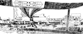
Attention to that full range of ideas is especially important in studying the recent past. The historiographical debate about the 1960s has recently become organized around a presentist version of the question of continuity-versus-change. Historians who plump for continuities look to elements of the present that emerged before the 1960s, while historians who emphasize change look to elements of the present that emerged during the 1960s.Footnote 164 These are important questions, and this is an important debate, but the full story of that era (no less than any other) is one of paths not taken as much as those that were, while a debate organized around these terms marginalizes the significance of disappointed ambitions that were no less part of the past. The cost is an understanding of the politics and processes by which possibilities that were not inevitable became (or failed to become) realized, and if urban history illustrates this problem, Pooley's history offers a way out. There is a subtle teleology at work when historians focus upon cities that were built: a whiggish selectivity favouring realized ideas, akin to tracking ‘truth’ through the history of science or ‘liberty’ through the history of politics, when what emerged in each case was produced through engagement with ideas that were subsequently discarded. We have seen this dynamic at work in the case of Milton Keynes, which emerged when, where, and how it did not as the unfolding of a ministry's plan, but rather through a contested process that included North Bucks New City. The story of North Bucks New City is significant in part because it disrupts this teleology, revealing a history that includes unrealized departures alongside built achievements, even if they can now only be glimpsed from the monorail's window (see Figure 3).
The view from the monorail. Drawing by Bill Berrett. Reproduced by permission of the Centre for Buckinghamshire Studies.