





Introduction
The Adriatic basin played a key role in the human and environmental dynamics of the Late Pleistocene in southern Europe. As global sea levels were low, the Mediterranean withdrew from the northern half of the Adriatic, leaving an open plain which acted as a corridor for the flow of people and technologies (e.g. Peresani et al. Reference Peresani, Monegato, Ravazzi, Bertola, Margaritora, Breda, Fontana, Fontana, Janković, Karavanić, Komšo, Mozzi, Pini, Furlanetto, Maria De Amicis, Perhoč, Posth, Ronchi, Rossato, Vukosavljević and Zerboni2021; Ruiz-Redondo et al. Reference Ruiz-Redondo, Vukosavljević, Tomasso, Peresani, Davies and Vander Linden2022), as well as a refugium for plant and animal diversity (e.g. Willis Reference Willis1994; Willis et al. Reference Willis, Rudner and Sümeg2000). This being said, any understanding of the corresponding complex human behaviours requires a robust control of the archaeological sequence and especially of its absolute chronology.
To this purpose, as for so many other regions of Upper Palaeolithic Europe, the availability of long-term site sequences coupling well-defined material assemblages with secure absolute chronologies is essential. However, in the case of the Adriatic basin, such reference sequences remain rare and, in some instances, their stratigraphic and chronological integrity is questioned (e.g. Šandalja II: Ruiz-Redondo et al. Reference Ruiz-Redondo, Vander Linden, Radović, Karavanić and Vukosavljević2024).
Here, we present a renewed stratigraphic sequence and absolute chronology for one of these sites, the rockshelter of Badanj, Bosnia and Herzegovina. As detailed below, the site of Badanj presents an exceptional character in the regional Upper Palaeolithic sequence due to the extensive lithic assemblages recovered, the general quality of the material culture, including numerous personal ornaments and bone tools such as harpoons, and the occurrence of a boulder with Upper Palaeolithic non-figurative engravings. Based on earlier excavations in the 1970s and 1980s, and recent fieldwork over the course of four field seasons since 2019, we now possess a total of 29 radiocarbon dates for the site, of which 22 come from secure stratigraphic contexts, a unique documentary situation for the Late Pleistocene of the Adriatic basin. This new stratigraphy and radiocarbon evidence, coupled with Bayesian modeling, allows us to re-assess the duration of use of the site, and its role in the wider chronological and cultural development of the Late Pleistocene in the region.
Site background and recent excavations
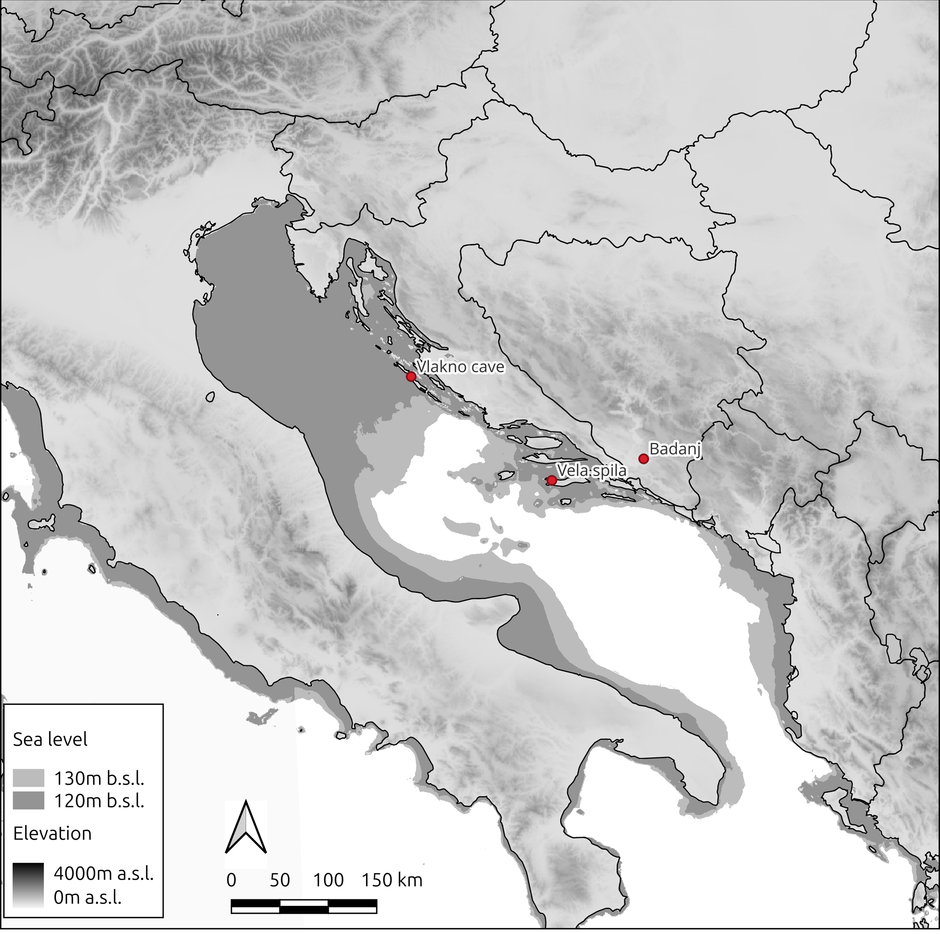
The site of Badanj lies in the municipality of Stolac, Bosnia and Herzegovina (at UTM 33T 734895X 4773884Y, and 75m a.s.l.; Figure 1). This large open south-facing rockshelter is situated on a slope some 30 m above the base of the gorges of the Bregava river valley, a natural corridor linking, to the west, the valley of the Neretva river (which flows into the Adriatic sea) and, to the east, the Bosnian mountainous hinterland.
Distribution map showing location of Badanj and key sites mentioned in the text.

This major Upper Palaeolithic site was first identified in 1974, when lithic artefacts were discovered by local people and subsequently reported to Đuro Basler, curator of Palaeolithic collections at the Zemaljski muzej of Sarajevo. Basler immediately recognised the potential of the site and began excavations (Basler Reference Basler1976, Reference Basler and Sonneville-Bordes1979). With over 20,000 lithic remains recovered during the initial campaign, Basler’s excavations revealed an extremely rich site dated to the Late Pleistocene, more specifically to the Late Epigravettian. The finds also included hundreds of personal ornaments and dozens of engraved bone fragments, both rare elements within the known Upper Palaeolithic record at the time—and even today—in the Balkan Peninsula (see Borić et al. Reference Borić, Cristiani, Pravidur, Marić and Whallon2023; Kujundžić Reference Kujundžić1989; Ruiz-Redondo et al. Reference Ruiz-Redondo, Garate, González-Morales, Janković, Jaubert, Karavanić, Komšo, Kuhn, Mihailović, Moro Abadía, Vander Linden and Vukosavljević2020). This first campaign also led to an even more exceptional discovery in the form of a large, engraved boulder. The carvings are located on the upper face, whose surface dimensions are approximately 4 × 2.7 m, and the maximum height of the boulder is 2.3 m. Hundreds of deeply engraved features were found on the boulder, and, as a great portion of it was covered by the “untouched” Upper Palaeolithic layers, the Palaeolithic age of the discovery is secure (Basler Reference Basler1976, Reference Basler and Sonneville-Bordes1979). Badanj thus became the first Upper Palaeolithic rock art site discovered in the Balkan Peninsula, an area where such category of finds remains rare, especially in comparison to other parts of Europe (Ruiz-Redondo et al. Reference Ruiz-Redondo, Garate, González-Morales, Janković, Jaubert, Karavanić, Komšo, Kuhn, Mihailović, Moro Abadía, Vander Linden and Vukosavljević2020).
Basler’s work at Badanj remains largely unpublished, with only a few papers presenting the basic typological characteristics of the lithic industry and rock art, along with brief mentions of personal ornaments, osseous artefacts, and mobiliary art (Basler Reference Basler and Sonneville-Bordes1979, Reference Basler1976). Additionally, plans and stratigraphic profiles from the excavation have not been published. In his field diaries, Basler noted that the maximum depth reached below the surface was 210 cm. He also recorded encountering a sterile layer composed of a sandy matrix and numerous angular rocks approximately 150–160 cm below the surface. Beneath this layer, he reported the presence of an artefact-bearing deposit. There is no mention of reaching bedrock in the available diary entries (Basler Reference Basler1977–Reference Basler1986). By the time he concluded his excavations at Badanj in 1979, Basler was nearing retirement and had begun shifting his focus toward later periods, particularly Early Christian archaeology and museological work, which will constitute his key interests until his death in 1990. This shift likely accounts for the limited publication output related to his investigations at the site.
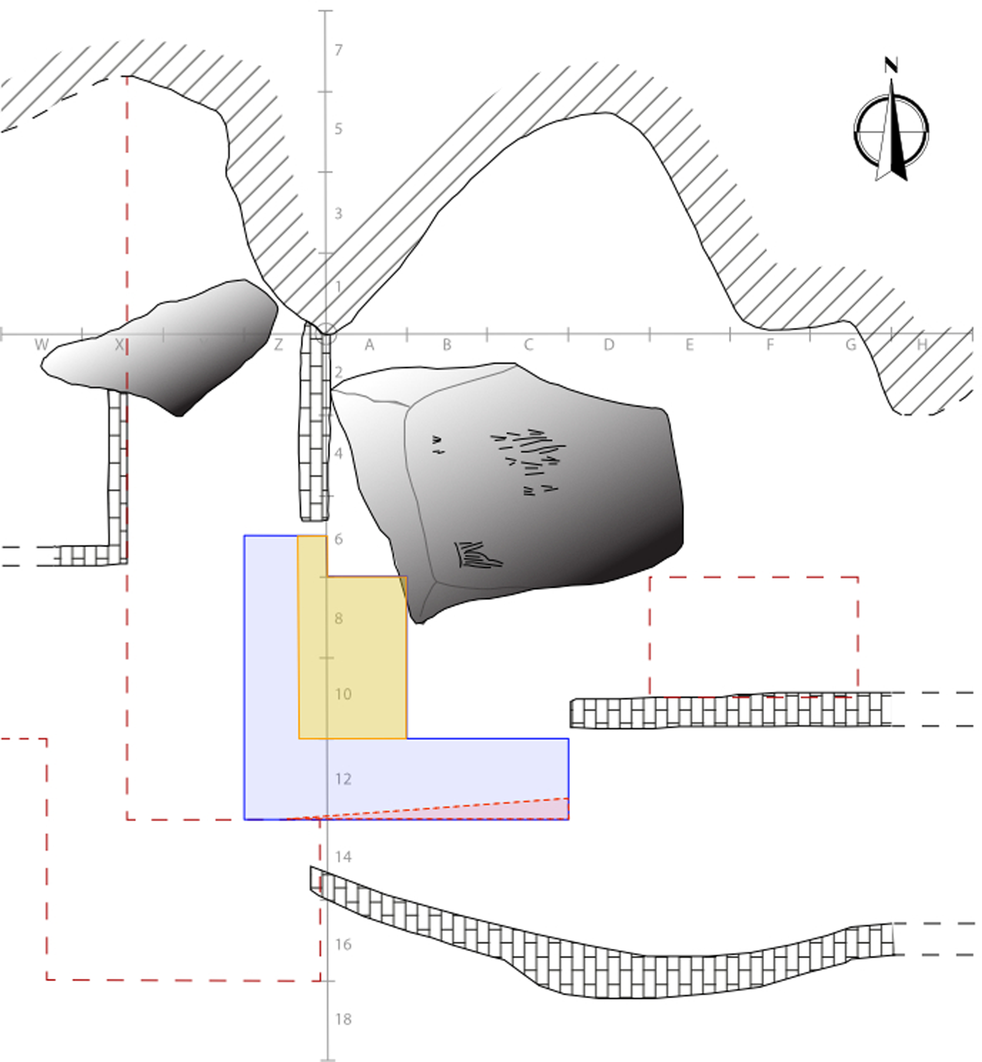
Given the richness and significance of the site, as well as the lack of detailed analyses of the recovered materials and the field methods employed—Basler excavated the deposits arbitrarily in 10 cm spits, and at times even in considerably thicker ones of 30 to 40 cm—excavations resumed in the form of two additional field campaigns during the 1980s as a joint project between the Zemaljski museum and the University of Michigan Museum of Anthropology, under the joint direction of Zilka Kujundžič and Robert Whallon (Whallon Reference Whallon1989, Reference Whallon1999). This work aimed at exposing horizontally in the western part of the site an area similar to the original surface (see Figure 2, areas indicated by red dashed lines) This work confirmed the exceptional character of the site, especially in view of the quantity and variety of the material assemblage. The main objectives of the 1980s excavations were to refine the definition of the archaeological sequence and to obtain information about the site’s chronology within the broader regional Palaeolithic–Mesolithic framework, as well as to contribute to palaeoenvironmental reconstruction (Whallon Reference Whallon1989). Over a stratigraphy less than a meter thick, Whallon identified 29 levels and depositional units, grouped into four main categories: 1) a series of thin layers extending over the front and middle of the rock shelter, 2) another series of layers towards the rear of the shelter, interpreted as probably water-deposited, 3) deposits around a hearth complex, showing extensive mixing, and 4) so-called basins or pits with mixed ash and land snails toward the top of the sequence. Whallon interpreted the first two categories as respectively individual episodes of occupation and corresponding trash deposits. He eventually concluded that 20 levels provided secure stratigraphic context, suitable for technological and typological of the lithic assemblage, attributed to the Late Epigravettian. Excavations were stopped when reaching a level described as a sterile éboulis.
Plan of the excavations at Badanj. Red dotted line indicates the extent of the 1970s and 1980s excavations, while the yellow and blue areas correspond to the phasing of the recent fieldwork.

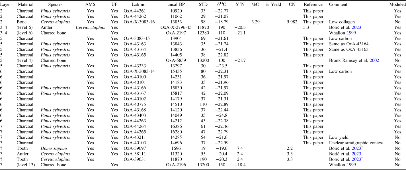
By contrast to the richness of the material and stratigraphic record, the absolute chronological information remains very limited. In his publication, Whallon relied upon only two radiocarbon dates (Whallon Reference Whallon1999), both made on burnt bone; the first one comes from the bottom of the sequence (level 13, OxA-2196), and the second one from the middle (layer 6, OxA-2197). On basis of this limited evidence, and assuming a constant rate of deposition, he estimated that the end of the sequence must have lasted approximatively a further 1,000 years, placing it, as also suggested by the fauna, to the Bølling-Allerød. Since, a further few dates have been published. The first one, also on burnt bone, comes from level 4. Although stratigraphically located above level 6, the corresponding date (OxA-5859) is significantly earlier, pointing to either mixing or residuality (Bronk Ramsey et al. Reference Bronk Ramsey, Higham, Owen, Pike and Hedges2002). Lastly, two radiocarbon dates have been obtained for bone harpoons discovered during Basler’s and subsequent Whallon’s and Kujundžić’s excavations (Borić et al. Reference Borić, Cristiani, Pravidur, Marić and Whallon2023). The first one also comes from level 6 and, although the sample (OxA-2795-45) has a low collagen yield and the result is affected by a large standard deviation, it remains in broad agreement with the previously available date. The last sample (OxA-38111) does not have any stratigraphic context, but, on the basis of typological comparisons with other artefacts, is thought to belong to the top levels. This typo-chronological hypothesis is confirmed by the date, which points to the late 14th mill. cal BP (Borić et al. Reference Borić, Cristiani, Pravidur, Marić and Whallon2023). It is also worth pointing out the existence of a couple of further radiocarbon dates, including one human tooth dated to the early 2nd mill. cal BP, which are reported in the online pre-print of the paper by Borić and colleagues (Reference Borić, Cristiani, Pravidur, Marić and Whallon2023), but absent from the published version. These are reported here (see Table 1) but not included in any further work, as at least for one date, the reason for discarding it by the original authors is unknown.
Radiocarbon determinations for the site of Badanj, Bosnia & Herzegovina

Table 1 Long description
The table presents radiocarbon determinations for the site of Badanj, Bosnia & Herzegovina. It includes 30 rows and 14 columns. The columns are labeled as Layer, Material, Species, AMS, UF, Lab no., uncal BP, STD, δ13C, δ15N, %C, % Yield, CN, Reference, Comment, and Modeled. The table lists various materials such as charcoal, bone, antler, and tooth, along with their respective species, lab numbers, uncalibrated BP values, standard deviations, and other relevant data. Each row provides detailed information about the specific sample, including the layer it was found in, the material type, species, and various measurements and references.
* Dates not included in the final referenced article. See “Site background and recent excavations” section for details.
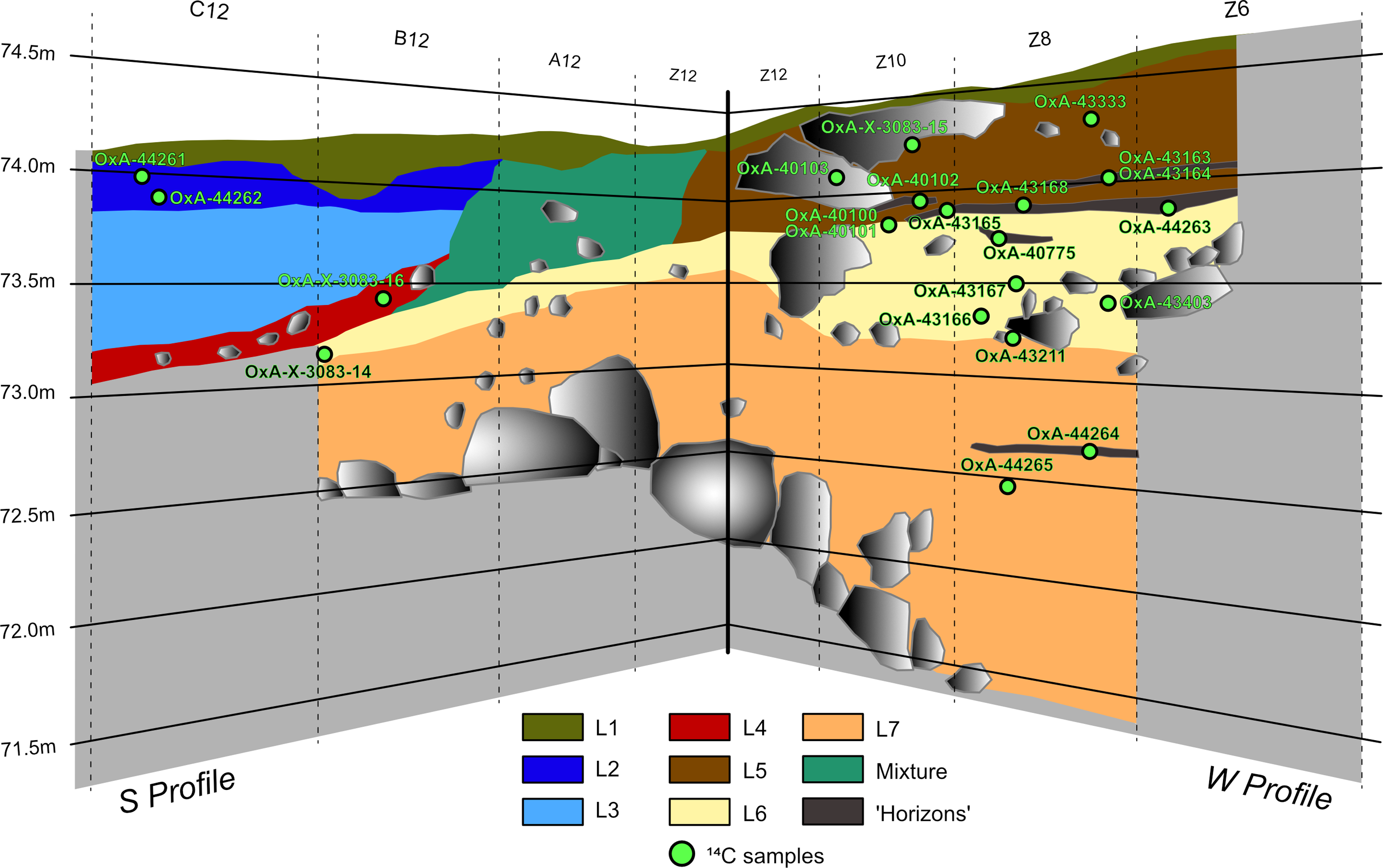
Given its exceptional character and the comparatively relative paucity of the published literature, an international team co-directed by two of us (ARR, NV) has been re-excavating the site since 2019 (Figure 2). During three field seasons, our primary objectives were to clean and extend the original profile of Basler’s trench, to establish a reliable stratigraphic sequence, to acquire a new range of samples, including for radiocarbon analysis, and to recover enough material in a controlled archaeological context to analyze the characteristics of the Upper Palaeolithic human occupations. This led to a new stratigraphy (Figure 3). The key result is that archaeological sequence does not stop at the layer defined as “sterile éboulis” by Whallon (Reference Whallon1989, Reference Whallon1999), but actually extends for a further 1.5–2 m down in some areas. Below these archaeological layers, we stopped the excavation at a collapse of large (>1 m length) boulders, which covered the entire extent of the trench, thus preventing us to reach the bedrock.
Stratigraphic profile from the recent excavations.

Figure 3 Long description
A cross-sectional view of an archaeological site. The section is divided into multiple horizontal layers, each with distinct colors and labels. The layers are labeled as L1 to L7 and Mixture, with corresponding colors. Various samples are marked with green dots and labeled with codes such as OxA-44261, OxA-44262, and others. The section is oriented with the S Profile on the left and the W Profile on the right. The vertical scale on the left ranges from 71.5 meters to 74.5 meters. The layers contain different textures and shapes, including large gray shapes representing rocks or artifacts.
In addition, we have identified complex processes of erosion and re-sedimentation visible in the southern profile (with the assistance of geoarchaeologist C. Ferrier), which have led us to reconsider the original sequence and propose a revised interpretation of the stratigraphy. Our understanding of the formation of the currently known deposit is as follows:
-
• Layer 7 is an orange-lime coloured layer lying over the collapse. It is over 1.5 m in its thickest part, and the density of material is low, except for some lenses with abundant charcoal. The engraved boulder fell on this deposit and we have dated a radiocarbon sample underneath it, thus providing a terminus post quem for the engravings (OxA-44265).
-
• Layer 6 is a thick yellow éboulis deposited immediately on top of layer 7 and seems to correspond to R. Whallon’s description of “sterile éboulis.” This is however at odds with our recovery of thousands of archaeological remains from it.
-
• Layer 5 is a brown éboulis that was apparently detected and partially excavated by Whallon. This layer is only present in the western profile and entirely absent in the southern profile. By comparison, the southwestern profile only shows a heavily mixed layer (marked in Figure 3 in squares Z12, A12, and B12). This mixture is clearly visible to the naked eye through the presence of éboulis (gravels, i.e. layer) and matrix components characteristic of Layers 2, 3, and 4 (see below). This mixing is likely due to differential erosive processes that occurred after the deposition of layer 5.
-
• Layers 4–1: layer 5 is absent in the SE area of our excavation, as it was possibly erased by this suggested erosion event. By contrast, this area presents three other archaeological layers, labeled layers 4, 3 and 2 respectively. Layers 4, 3, and 2 lack éboulis and exhibit a brownish coloration and, suggesting a potential organic component. This is not surprising, considering that these layers have yielded a high density of archaeological material indicative of intensive human occupation, particularly in layer 4. We conventionally named the surface layer as layer 1 in the entire excavated area.
Data and methods
Systematic sampling for radiocarbon dating was undertaken during our recent field seasons, with a total of 43 samples selected for analysis. In view of the history of sampling on site and the general poor preservation of collagen, our strategy combines bones and teeth (n=16) and charcoal (n=27). In all instances, species identification was undertaken prior to submission to the Oxford Radiocarbon Accelerator Unit, Research Laboratory for Archaeology and the History of Art. All samples were then subject to the standard pre-treatment and AMS counting in place at the ORAU facility (Brock et al. Reference Brock, Higham, Ditchfield and Bronk Ramsey2010; Bronk Ramsey et al. Reference Bronk Ramsey, Higham and Leach2004).
Bone and tooth samples did not contain any preserved collagen, with a single exception characterised by a low collagen yield. Six further charcoal samples did not produce any reading due to poor preservation and/or low amount of carbon. Our new sampling thus amounts to 22 dates (1 bone, 21 charcoal). As a result, the Badanj sequence is now represented by 29 dates, a three-fold increase from the previously available documentation. All dates and contextual information are reported in Table 1. The stratigraphic labeling corresponds to our recent field observations with, when appropriate, indication in brackets of the original description derived from the 1980s fieldwork. It is worth pointing out that we were not able to assess the exact stratigraphic location of all samples, a limit taken into consideration in the elaboration of our Bayesian models.
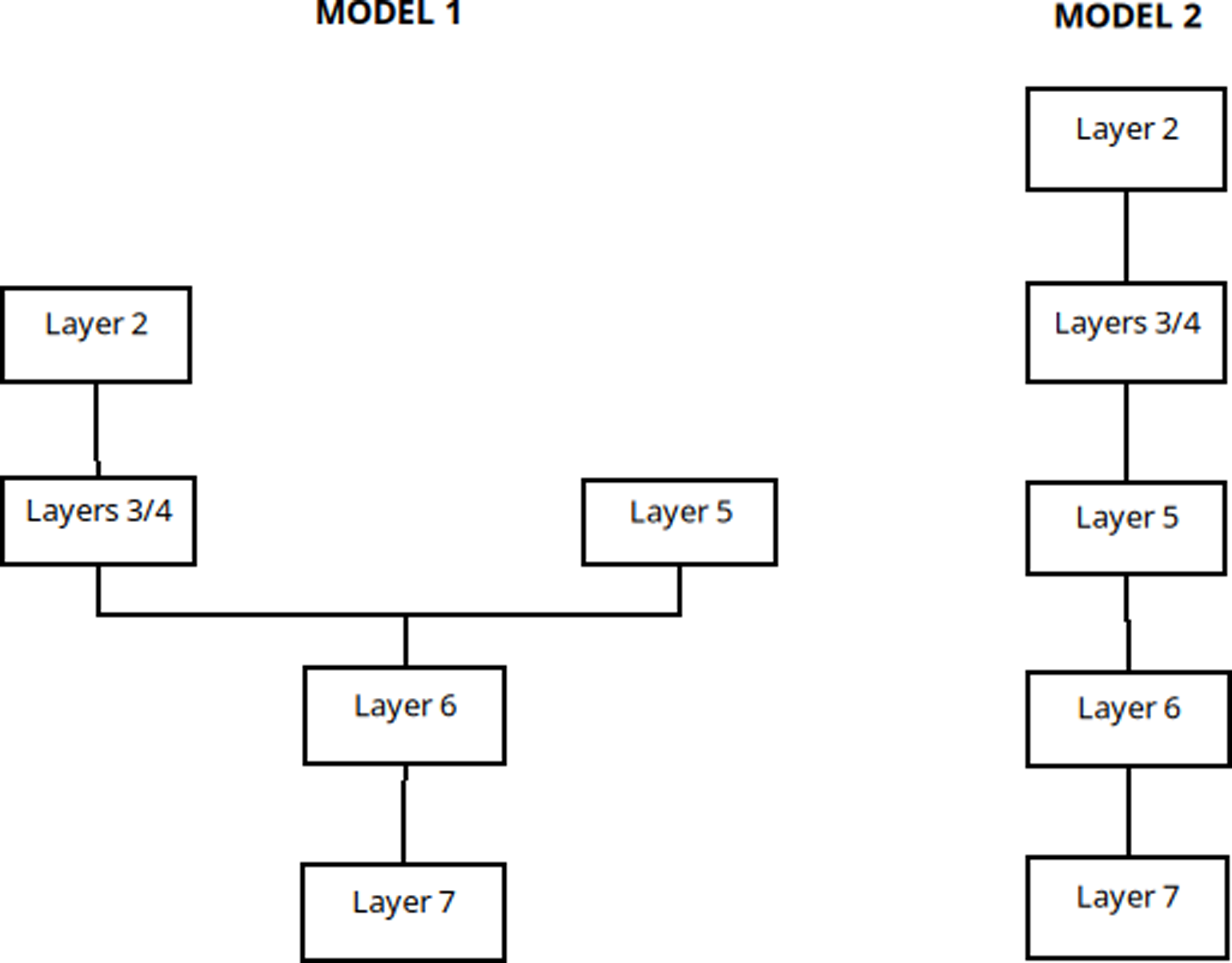
Here, we are privileging stratigraphy as a robust, independent prior, at the difference of the model set forth by Borić and colleagues (2023) which mixed stratigraphy, assumption about potential residuality and typo-technological considerations. Our renewed description of the stratigraphy was used as prior information in the creation of two competing Bayesian models. Both models share the same general architecture as sequences with bounded phases and assume a simple succession from layer 7 to layer 6. Our first model takes into account the uncertainty regarding the relationship between layers 5, 4 and 3 by setting up two parallel phases. By contrast, our second model assumes partial erosion of layers 6 and 5, followed by a continuous sequence of deposition for the rest the stratigraphy. Model architecture is summarised on Figure 4. Both models include the same radiocarbon dates, for which exact stratigraphic position was either known or inferred through comparison between the 1980s and recent fieldwork. Initial versions of the models took into consideration date OxA-X-3083-16, which had been flagged by the ORAU laboratory as potentially problematic given the low collagen yield. This suggested lack of accuracy, indicated by discrepancy with other dates from the same contexts, and the facts that all models either failed to converge or to provide satisfactory Amodel values (i.e. above minimal threshold of 60). As a consequence, this date was omitted from the final versions of the model, whose results are discussing in the next section. Models were written and run in Oxcal v4.4 (Bronk Ramsey Reference Bronk Ramsey2009), and all calibration was undertaken using the Intcal 2020 calibration curve (Reimer et al. Reference Reimer, Austin, Bard, Bayliss, Blackwell, Bronk Ramsey, Butzin, Cheng, Lawrence Edwards, Friedrich, Grootes, Guilderson, Hajdas, Heaton, Hogg, Hughen, Kromer, Manning, Muscheler, Palmer, Pearson, van der Plicht, Reimer, Richards, Marian Scott, Southon, Turney, Wacker, Adolphi, Büntgen, Capano, Fahrni, Fogtmann-Schulz, Friedrich, Köhler, Kudsk, Miyake, Olsen, Reinig, Sakamoto, Sookdeo and Talamo2020). Corresponding scripts and raw outputs are provided as supplementary materials.
Diagram of the architecture of both Bayesian models.

Results
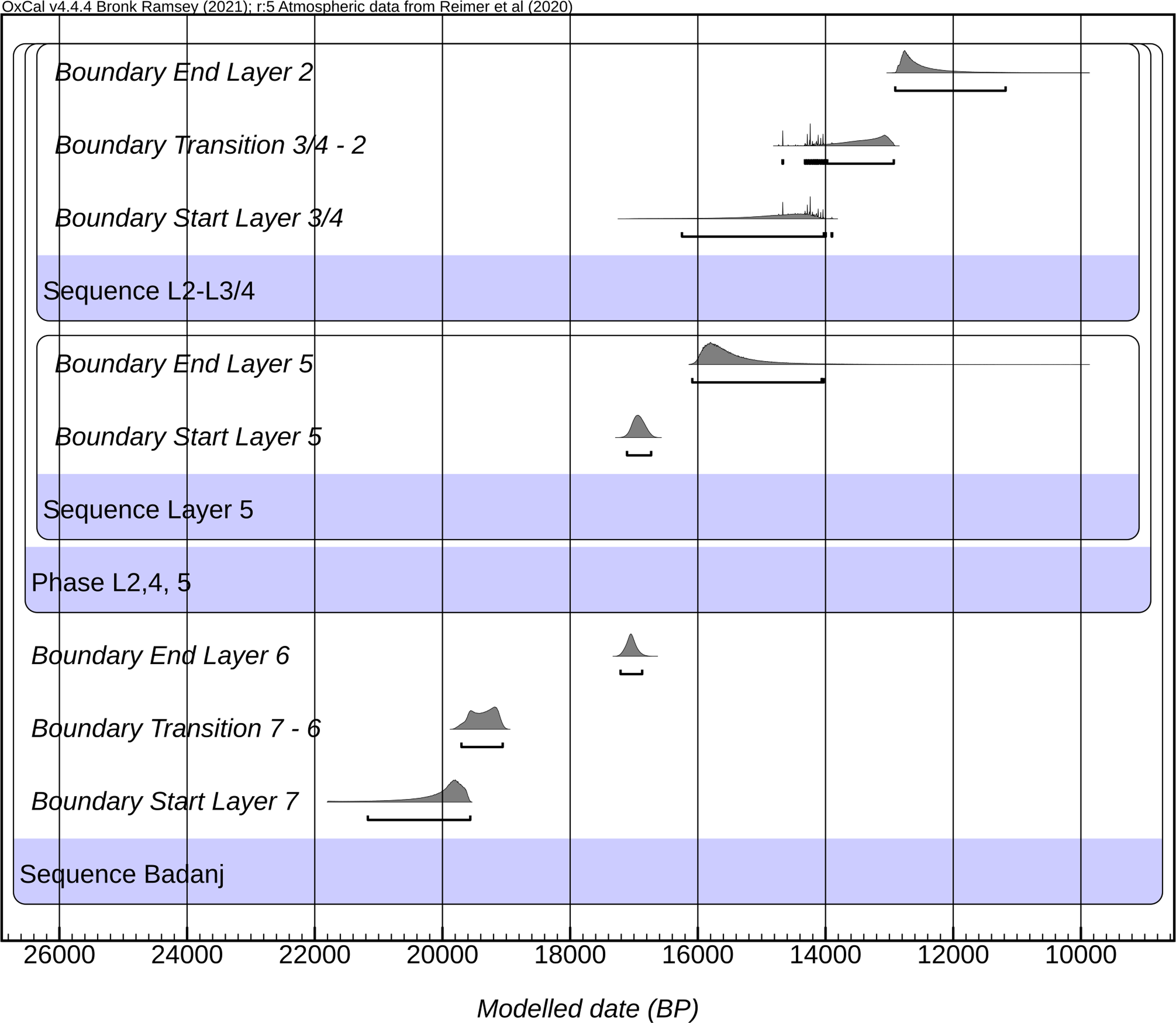
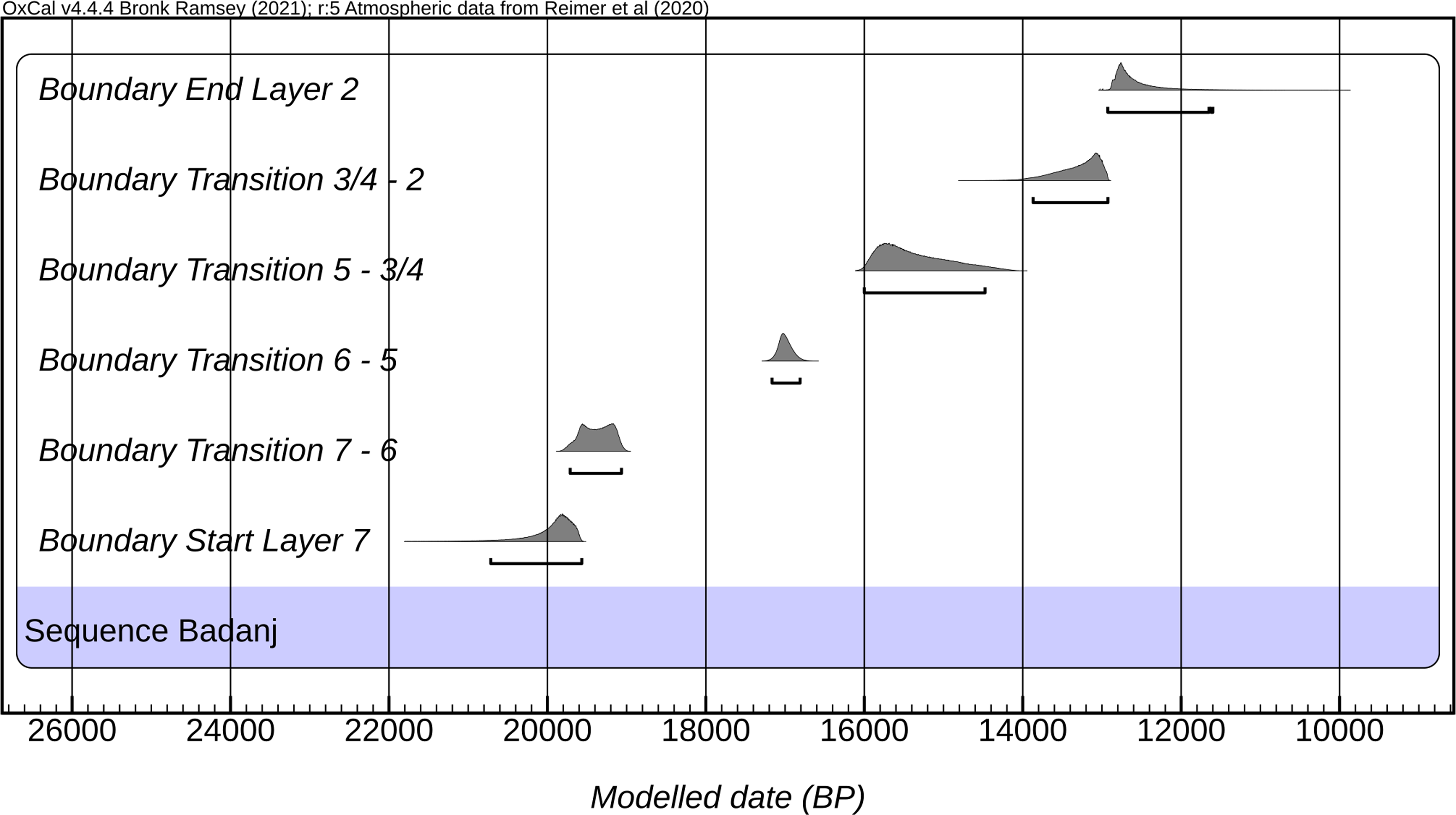
The results of our two Bayesian models are provided in Figures 5 and 6 (see also Figures S1 and S2 for full outputs). Both models provide satisfactory Amodel values, somewhat higher for model 2 (model 1: Amodel 90.5, Aoverall 89.9; model 2: Amodel 95.5, Aoverall 95.1).
Probability distributions of key parameters for Badanj, model 1.

Probability distributions of key parameters for Badanj, model 2.

As both models share the same architecture for layers 7 and 6, they return closely related results for the lower part of the stratigraphy. The beginning of the sequence dates to 21,120–19,560 cal BP (model 1, 95.4%) or 20,720–19,560 cal BP (model 2, 95.4%), probably 20,150–19,600 cal BP (model 1, 68.3%) or 20,020–19,610 cal BP (model 2, 68.3%). The longer boundaries returned by model 1 are most likely an artefact related to the differing structures of both models. By comparison, they return almost identical estimates for the transition between layers 7 and 6, dated to 19,690–19,050 cal BP (model 1, 95.4%; model 2: 19,710–19,050 cal BP), probably 19,580–19,100 cal BP (model 1, 68.3%; model 2, 68.3%: 19,600–19,110 cal BP). Using the interval function, both models estimate the duration of layer 7 to up to 1890 years, though it is worth reminding that this result is solely based on a couple of dates. Both models, though differing in their structure at this point, provide comparable estimates for the span of layer 6, estimated to end by 17,200–16,870 cal BP (model 1; 95.4%) or 17,170–16,820 cal BP (model 2; 95.4%), probably 17,130–16,970 cal BP (model 1; 68.3%) or 17,100–16,930 cal BP (model 2; 68.3%), thus pointing to a duration between 2000 to 2750 years for layer 6.
Although both models present diverging architecture from this point onwards, they provide generally similar results. Model 1 places the start of layer 5 between 17,110 and 16,740 cal BP (95.4%), probably between 17,040 and 16,840 cal BP (68.3%), thus overlapping largely with the estimates for the end of layer 6. According to model 1, layer 5 ends between 16,170 and 13,220 cal BP (95.4%), probably between 16,090 and 15,270 cal BP (68.3%), for a duration estimated between 640 and 3800 years (95.4%; 790–1690 years at 68.3%). Model 2 places the transition between layers 5 and 3/4 from 16,070 to 14,420 cal BP (95.4%), probably 16,010 to 15,090 cal BP, for a duration of 880 to 2630 years (95.4%; 980–1980 years at 68.3%). Here also, the outputs of both models are comparable and the tighter estimates of model 2 are likely to be related to its architecture.
Model 1 places the start of layers 3/4 between 16,310 and 14,050 cal BP (95.4%), probably 15,020 and 14,140 cal BP (68.3%), a result which largely overlaps with that of model 2 (see above). Both models also largely concur regarding the transition between layers 3/4 and layer 2, set at 13,990 to 12,920 cal BP (model 1, 95.4%) or 13,880 to 12,900 cal BP (model 2, 95.4%), probably 13,520 to 12,960 cal BP (model 1, 68.3%), or 13,430 and 12,900 cal BP (model 2, 95.4%). While both models return a maximum duration of up to 3030 years (95.4%), they however differ profoundly in their estimate of the minimum duration, placed at 0 year in model 1, and from 880 (95.4%) to 980 years (68.3%) by model 2.
The end of the sequence, corresponding to the end boundary of layer 2, is dated between 12,960 and 11,250 cal BP (model 1, 95.4%), or between 12,970 and 11,670 cal BP (model 2, 95.4%), probably 12,880 and 12,430 cal BP (model 1, 68.3%), or 12,920 and 12,530 cal BP (model 2, 68.3%). Both models provide slightly different estimates of the duration of layer 2, set at 0 to 2340 years (model 1, 95.4%), or 0 to 1880 years (model 2, 95.4%), probably 200 to 1130 years (model 1, 68.3%), or 0 to 940 years (model 2, 68.3%).
Discussion
Our fieldwork implies a renewed reading of the site stratigraphy. The previous dates for Whallon’s Layer 6 chronologically fit in-between our layers 2 and 5 but the exact stratigraphic correspondence remains uncertain. We inferred the equivalence between Whallon’s layer 4 and our layer 5 based on their respective positions and descriptions (Borić et al. Reference Borić, Cristiani, Pravidur, Marić and Whallon2023). Our general reading of the stratigraphy differs from that described by Whallon, in that we only identify a total of seven layers, where Whallon considered the possibility of over 20 depositional units and layers. Several potential reasons may account for this discrepancy. One possibility is the presence of local differences in sedimentation across different parts of the rock-shelter. However, a more likely explanation is our more conservative approach to the definition of stratigraphic layers, whereby small lenses within thicker depositional units were not treated as separate stratigraphic entities but rather as internal variations within layers, primarily distinguished by differences in color tone. All in all, this new interpretation of the stratigraphy, coupled with the identification of new layers, provides robust independent priors for Bayesian modeling of the newly acquired radiocarbon dates.
As shown in the Results section, the two models developed here, despite slightly different architectures mirroring two distinct readings of the upper section of the stratigraphy, return results largely in agreement, with some minor discrepancies due to the choice of priors. The distinction between both models rests upon whether or not we accept the existence of an erosion event which would explain the stratigraphic discrepancies between both sectors of the sequence. Given the problems linked to the characterisation of the “mixture” layer, and that the definitive identification of this potential erosion event would require careful consideration of geomorphological features not available at this stage, here, we privilege a parsimonious reading of the stratigraphy and consider model 1 to be more reliable. The rest of the discussion is thus based upon this set of chronological estimates.
The results presented here have sound implications for our current knowledge of the Upper Palaeolithic of the Adriatic basin. The first key point is that, thanks to our renewed excavation and associated radiocarbon sampling program, we can now state that the Badanj sequence reaches as far back as ca. 21,000 to 19,500 cal BP, keeping in mind that the bedrock has not been reached. Not only does this expand the duration of use of the site by at least five thousand years, but this also implies that the Badanj rockshelter joins the short list of Early Epigravettian sequences documented for the moment in the Eastern Adriatic. Furthermore, it becomes, after Vela Spila (Dean et al. Reference Dean, Pappalardo, Boschian, Spada, Forenbaher, Juračić, Felja, Radić and Miracle2020) and Vlakno (Vitezović et al. Reference Vitezović, Vujević and Radović2024), the third recently excavated site in the region that comprises the LGM-LGT. However, as our results rest only upon a couple of radiocarbon dates, further sampling would very likely improve both accuracy and precision. It is also worth noting that, even considering its two-sigma range, layer 7 seems to start after the gap in human activity across the region identified for the Eastern Adriatic during the first half of the 22nd mill. cal BP (Ruiz-Redondo et al. Reference Ruiz-Redondo, Vukosavljević, Tomasso, Peresani, Davies and Vander Linden2022).
By contrast, the place and duration of layer 6 are well secured thanks to a comprehensive number of dates. With an estimate duration lasting over two millennia, it is perhaps not surprising to see that this layer is actually difficult to place neatly in the existing chronological sequence for the Adriatic, and it covers both the end of the Early Epigravettian, and the transition between the Early and Late Epigravettian, set at around 17,500–17,000 cal BP (Ruiz-Redondo et al. Reference Ruiz-Redondo, Vukosavljević, Tomasso, Peresani, Davies and Vander Linden2022). Likewise, layer 5 also partially bridges this transition. Ongoing analyses of the material culture from layers 5 and 6 are expected to provide insights into the characteristics and potential distinctions between the two Epigravettian techno-complexes. Early Epigravettian lithic assemblages in the Eastern Adriatic are rare, with only a few sites—such as Vlakno Cave, Vela Spila, and Badanj—preserving stratigraphic sequences that encompass the transition from the Early to Late Epigravettian. These Early Epigravettian assemblages are typically small in size and originate from limited excavation areas (Vukosavljević Reference Vukosavljević, Ruiz-Redondo and Davies2023). Consequently, a systematic comparison between the Early and Late Epigravettian is still lacking. However, integrating data from the three aforementioned sites offers the potential to shed new light on the similarities and differences between these two complexes.
The chronological positioning of layers 3/4 is marred by uncertainty, as it relies upon only two dates acquired on material from the Whallon excavations, one of them being on a barbed point. Despite these limits, these layers firmly sit within the Late Epigravettian. Barbed points from Vlakno Cave have been recovered from the upper portion of Stratum 6 (Phase 6.2), which is dated to approximately 15,000 cal BP (Vitezović et al. Reference Vitezović, Vujević and Radović2024), and thus overlap with the onset of our layers 3/4. From an environmental point of view, these layers largely overlap with GI1 (see Rasmussen et al. Reference Rasmussen, Bigler, Blockley, Blunier, Buchardt, Clausen, Cvijanovic, Dahl-Jensen, Johnsen, Fischer, Gkinis, Guillevic, Hoek, Lowe, Pedro, Popp, Seierstad, Steffensen, Svensson, Vallelonga, Vinther, Walker, Wheatle and Winstrup2014).
The top of the sequence, corresponding to layer 2, is set between ca. 14,000 to 11,600 cal BP, which makes it overlap with the date on bone harpoon for which no stratigraphic context is available (Borić et al. Reference Borić, Cristiani, Pravidur, Marić and Whallon2023). Two of the three barbed points recovered during our excavations come from this layer. It is worth pointing out that the late estimate provided here is linked to the fact that this part of the model only includes two dates, and to the conservative approach to calculating boundary by OxCal (as the late non-modeled range for both dates otherwise does not extend beyond 12,750 cal BP). In this sense, it is difficult to appraise the exact end point of the preserved Upper Palaeolithic Badanj sequence, though Whallon’s original estimate seems valid. Indeed, layer 2 largely overlaps with GI1, but only with GS-1 if one considers the full two sigma range of the boundary.
These observations have significant implications for the chronology of the engravings found on the surface of the boulder. As noted, the boulder fell onto layer 7, and a charcoal sample recovered from beneath it provides a terminus post quem for the fall of the boulder and, by extension, for the creation of the engravings (OxA-44265; unmodeled 19,840–19,520 cal BP, 95.4%; 19,805–19,540 cal BP, 68.3%). Most—or possibly all—of the boulder’s surface was originally covered by layers 6 and 5. Therefore, an initial chronological hypothesis for the production of the engravings places them between the aforementioned date and the end of the deposition of layer 5. The subsequent suggested erosion phase, which removed all of layer 5 and part of layer 6, likely re-exposed at least part of the boulder’s surface. This surface was eventually covered again by layer 2. A second hypothesis therefore suggests that the engravings could have been made between the deposition of layers 4 and 2. Finally, the most conservative hypothesis posits a broader chronological range for the creation of the engravings, placing them sometime between the formation of layers 7 and 2, i.e. approximately 21,000 to 12,000 cal BP.
Conclusion
Our new combined fieldwork and extensive program of radiocarbon dating demonstrates that the Badanj rock-shelter was occupied between 20,000 cal BP and 12,000 cal BP, thus expanding the previously dated sequence by 5000 years. Furthermore, this updated chronology includes now several key transitional moments in both environmental and cultural terms, such as the LGM-LGT (ca. 19 ka cal BP) and the Early-Late Epigravettian transition (ca. 17.5 ka BP).
Despite some uncertainty given the nature of the stratigraphy and the failure to obtain new radiocarbon dates for layers 3 and 4, the presented data demonstrates occupation throughout the entire Late Upper Palaeolithic. Considering the importance of Badanj sequence and the richness and variety of its material culture, these results are essential to provide an appropriate framework for properly analyzing the features, changes and innovations of the social and cultural structure of the period in the Eastern Adriatic. Ongoing analyses on the material culture, symbolic behavior, environmental proxies and subsistence strategies coming from the new excavations of the site will provide new insights on the Epigravettian culture in the Adriatic basin and the adaptations and changes that took place during the Late Glacial in the central and eastern Mediterranean.
Supplementary material
To view supplementary material for this article, please visit https://doi.org/10.1017/RDC.2026.10220
Acknowledgments
This research has received financial support from the British Academy through the PALAEOARTEAST (“Defining cultural boundaries in the European Upper PALAEOlithic: Archaeology and Rock arT in EASTern Europe”) and PLEISTOCEM (“PLEISTOcene symbolic behaviour in Central and Eastern Mediterranean: art, cultural transmission and mobility strategies during the Epigravettian”) projects, led by ARR within the framework of the Newton International Fellowship program (NIF\R1\180205 and NA21\210005). This paper was produced within the framework of the institutional research project Eastern Adriatic Transitions: Human Adaptation and Material Culture from the Last Glacial Maximum to the Emergence of the First Farmers (ITRANZ) of the Faculty of Humanities and Social Sciences, University of Zagreb, funded by the Recovery and Resilience Facility of the European Union – NextGenerationEU. The views and opinions expressed are those of the author(s) and do not reflect the official position of the European Union or the funding authority. We also wish to thank Ante Vujnović, the Town of Stolac and its Mayor Stjepan Bošković for their longstanding support of the fieldwork at Badanj.


 Open access

