Settlement boundaries are notoriously difficult to identify in the archaeological record. In the Maya area, few cities, communities, or polities were physically delineated with boundary walls or features. Marked exceptions include the Classic period Tikal earthworks, the wall encircling the Postclassic city of Mayapan, and the Classic period defensive border walls between Yaxchilan-affiliated and Piedras Negras-affiliated sites (Golden et al. Reference Golden, Scherer, Muñoz and Vasquez2008; Golden and Scherer Reference Golden and Scherer2013; Masson et al. Reference Masson, Hare, Lope, Schartz and Nichols2006; Puleston and Callender Reference Puleston and Callender1967; Webster et al. Reference Webster, Murtha, Straight, Silverstein, Martinez, Terry and Burnett2007). Even when physically marked, settlement boundaries were fluid zones, shifting in meaning and belonging as people moved about the landscape and reformulated their relations with each other. Such fluidity and ambiguity between settlements are compounded by the characteristic nature of Maya settlement patterns as extensive and dispersed rather than highly nucleated. Many scholars, in fact, have argued that the ancient Maya did not have a strong conception of territorial boundaries because organizational structures were based more on people than on land (Graham Reference Graham2011; Hammond Reference Hammond and Culbert1991).
Nevertheless, ethnohistorical data suggest that Maya peoples were indeed concerned with marking and remarking settlement and territorial divisions, although such demarcations often focused on natural landscapes, such as mountain tops, outcrops, caves, cenotes, springs, or inconspicuous human-made features such as small shrines (Hill Reference Hill1996; McAnany Reference McAnany1995; Roys Reference Roys1972; Tozzer Reference Tozzer1941). These boundaries were maintained through repeated visits and ritual circulations. Ritual circulations to mountain summits, water features, and boundary shrines are still common among contemporary Maya populations today (Bassie-Sweet et al. Reference Bassie-Sweet, Laughlin, Hopkins and Casimir2015; Tedlock Reference Tedlock1992; Vogt Reference Vogt1969). In turn, we propose that Late Postclassic inhabitants at the site of Tayasal, Petén, Guatemala constructed a border shrine at the eastern limits of their settlement (Figure 1). Comparison of the features of this shrine with others throughout the Maya area underscores a tension between built and unbuilt, settled and wild spaces that were potent, liminal realms between not only people and places, but also between earthly and otherworldly beings.
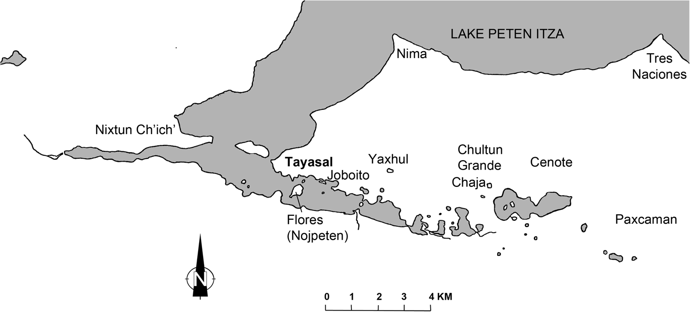
Map of the western side of Lake Petén Itzá showing the location of Tayasal in reference to other settlements (adapted from Chase Reference Chase1983:Fig.4-1).

Shrines in the Postclassic Maya World
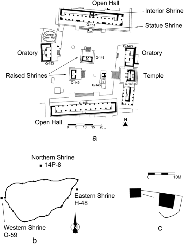
Shrines commonly appear as part of the architecture in public, ceremonial plazas within Postclassic Maya centers. For example, at the Late Postclassic city of Mayapan, Tatiana Proskouriakoff (Reference Proskouriakoff, Pollock, Roys, Proskouriakoff and Smith1962:89–92) documented what she called a “basic ceremonial group.” This arrangement of buildings around a plaza space included colonnaded halls, also known as open halls; different types of shrines, oratories, and, in some cases, temples (Figure 2a). Shrines included what she called “raised shrines,” which are independent one-room buildings located on raised platforms, “interior shrines” found within colonnaded halls, and “statue shrines” often located on the stairways or on low platforms in front of temples. In general, shrines are smaller than oratories, which typically have doorways and sometimes interior supports held up by two columns or piers. They are also less imposing than temples, which were built on a pyramidal base.
Shrines at the Postclassic site of Mayapan: a) Ch'en Mul ceremonial group (after Pugh Reference Pugh2003:Fig. 5 and Proskouriakoff Reference Proskouriakoff, Pollock, Roys, Proskouriakoff and Smith1962); b) border shrines at the northern, eastern, and western gates of Mayapan (gates represented by small circles; city wall represented by encircled line; adapted from Bradley Reference Russell2008:Fig. 9.4); c) eastern border shrine, public ritual group, Cluster H-48 (adapted from Bradley Reference Russell2008:Fig.9.5).

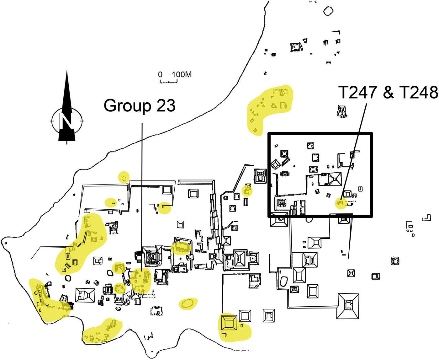
Subsequent research has revealed that similar configurations and types of ceremonial buildings are present at many Postclassic sites in the Southern Maya Lowlands, including the sites of Canté, Paxté, Ixlú, Muralla de Leon, Topoxté, and Zacpetén (Duncan Reference Duncan2011; Pugh Reference Pugh2003; Rice and Rice Reference Rice, Rice, Chase and Rice1985, Reference Rice and Rice2018; Schwartz Reference Schwartz2009). Some of the closest architectural parallels to those found at Mayapan are found at sites that may have been associated with the Kowoj Maya who were known to have migrated between the Northern and Southern Lowlands. At the site of Zacpetén, for example, temples were a component of basic ceremonial groups, and spatial configurations of the ceremonial buildings were similar between the two sites (Pugh Reference Pugh2003). Nevertheless, shrines and other ceremonial buildings are found throughout the Petén Lakes region, including areas likely dominated by the Itza. At Tayasal, adjacent to the Itza Maya capital of Nojpeten (Flores), one centrally located architectural group, Group 23, included an open hall, oratory, and at least one, if not two, raised shrines (T99A, T99B, T100, T95) dating to the Middle and Late Postclassic period (Figure 3; Chase Reference Chase1983, Reference Chase, Chase and Rice1985; Pugh et al. Reference Pugh, Sánchez and Shiratori2012; Ramírez Baldizón Reference Ramírez Baldizón2004). Postclassic period burials and numerous censers from these buildings suggest that the zone was an important Postclassic period ceremonial space, as it was in the earlier Classic and Late Preclassic periods. Postclassic residential structures surround this group to the north, west, and south, with greater densities of occupation close to the lower-elevation coastline.
Map of Tayasal showing the extent of Postclassic period settlement (shaded) and the North-Central Tayasal Archaeology Project study area (rectangular inset; see also Figure 4; map adapted from Chase Reference Chase, Chase and Rice1985:Fig. 2).

Isolated, Wilderness, and Border Shrines in the Maya Area and Beyond
Not all shrines are found within the centers of communities or at the heart of public ceremonial spaces. Bernal Diaz del Castillo (Reference Díaz del Castillo1963) noted that in the sixteenth century, numerous isolated shrines were strung along the Campeche coast of Mexico. Maya merchants and hunters traveling in canoes would visit these remote shrines and make offerings as they traveled far from their home communities. In the Southern Maya Lowlands, Postclassic shrines were sometimes constructed within abandoned Classic period ceremonial plazas (Andres and Pyburn Reference Andres, Pyburn, Demarest, Rice and Rice2004; Brown Reference Brown2011; Lorenzen Reference Lorenzen1999, Reference Lorenzen2003; Robin et al. Reference Robin, Meierhoff, Blackmore, Kosakowsky, Novotny and Robin2012). For example, at the site of Chan, Belize, Early Postclassic peoples built a small platform (2.0 x 2.6 m) in the center of site's Central Group, the monumental core of the site from the Preclassic to Classic periods (Robin et al. Reference Robin, Meierhoff, Blackmore, Kosakowsky, Novotny and Robin2012). Unlike the cardinal orientations of earlier Preclassic and Classic period architecture, the small platform was oriented in alignment with the intercardinal directions. No other architecture at the site contained Postclassic materials, and because Postclassic ceramic artifacts were found only within the Central Group and a single household, located over 1 km from the Central Group, it is likely that the shrine represented an isolated ritual zone away from major settlement.
Wilderness shrines, on the other hand, did not always require the construction of a small building or raised platform. Throughout the course of Maya history, caves, natural outcrops, mountain summits, and other natural features have served, and continue to serve, as important locations for rituals and pilgrimages (Bassie-Sweet et al. Reference Bassie-Sweet, Laughlin, Hopkins and Casimir2015; Borgstede Reference Borgstede2010; Brady and Prufer Reference Brady and Prufer2005; Brown and Emery Reference Brown and Emery2008; Thompson Reference Thompson1959; Woodfill Reference Woodfill2011). Although such features were integrated into settled space (Brady Reference Brady1997; Halperin Reference Halperin, Prufer and Brady2005; Pugh Reference Pugh, Prufer and Brady2005), they were also situated in distant locations away from settlements. For example, hieroglyphic texts indicate that Classic period dignitaries and ritual specialists from multiple polities in the eastern part of the Southern Maya Lowlands visited the cave site of Naj Tunich, located some distance from their polity capitals (Stone Reference Stone1995). The cave itself may have served as a neutral zone between polities. William Bullard (Reference Bullard1963) documents another example of a wilderness shrine located in an uninhabited section of the Mountain Pine Ridge, Belize. The undated shrine consisted of a small building (~4 m in height and less than 10 m in length and width), which faced two large granite boulders protruding up through the earth at the same relative height as the shrine. It appears that the granite boulders were conceived of as an equivalent to the shrine, given that both of these features were fashioned with a small altar at their base.
Isolated wilderness shrines were often involved in the making of boundaries. Mesoamerican colonial period documents, for example, reveal that settlements were founded on and reinforced through processional rituals that began at the center of the main plaza or ceremonial space and continued to the major outposts of the territory, often represented by caves, mountain tops, and other natural features (Garcia-Zambrano Reference Garcia-Zambrano, Robertson and Fields1994; Pohl et al. Reference Pohl, Monaghan, Stiver, Smithers, Sosa and Baracs1997; Taube Reference Taube, Gómez-Pompa, Allen, Fedick and Jimenez-Osornio2003). Such rituals often focused on visiting each cardinal direction, which served to replicate the four-cornered conception of the universe (Ashmore Reference Ashmore1991; Hutson and Welch Reference Hutson and Welch2014; Reese-Taylor Reference Reese-Taylor and Stone2002; Sorensen Reference Sorensen2010). Caves, outcrops, and mountaintops were not only critical spaces between settlements, but frontier zones between the earth and other cosmological realms. These features in the landscape were conceived of as the homes of, and access points to, ancestors, deities, and other spiritual beings, as well as the most precious items to humans: sacred water, corn, and other foodstuffs (Bassie-Sweet Reference Bassie-Sweet1991; Lorenzen Reference Lorenzen2005; Stone Reference Stone1995; Vogt and Stuart Reference Vogt, Stuart, Brady and Prufer2005).
Elsewhere in the world, rural and wilderness shrines were also commonly a part of the making of places. The Inka created a system of shrines (or huacas), including both unbuilt (springs, stones, mountaintops) and built forms, that linked the capital of Cusco with outlying regions in the valley (Bauer Reference Bauer2016; McEwan Reference McEwan and Bray2015). These shrines were connected by a system of lines known as “ceque,” which radiated out from Cusco's principal sun temple, Coricancha, to the outlying shrines. Although not always straight, such lines emphasized the act of movement and circulation, as kin groups from the capital were responsible for traveling along these paths to make offerings at the shrine locations. Likewise, in ancient Greece, rural shrines distant from urban centers helped demarcate the borders of a polis in addition to serving rural needs and as places of exchange (Polignac Reference Polignac1995). The shrine of Argive Heraim, for example, was located 9 km from the city of Argros. Like the Inka and Maya cases, the citizens of Argros paraded out to the shrine as a way to maintain their sense of territorial extent and civic identity (Alcock Reference Alcock1993).
Unlike the more distant rural and wilderness shrines referenced above, Maya peoples also established shrines and ritual spaces at the edges of settlements to delimit the frontiers of urban spaces (Maca Reference Maca, Robertson, Seibert and Fernandez2006; Sorensen Reference Sorensen2010). At the Late Preclassic/Early Classic site of T'isil in Quintana Roo, Mexico, a single large cenote marked the city's center, and four cenotes, each in the inter-cardinal directions, marked the edges of settlement. Although the site was densely inhabited, settlement densities diminished precipitously where the four outlying cenotes were located. The fact that one of the cenotes was human made underscores the flexibility in adopting both natural and humanly modified features in the making of place.
Much later in time, Bishop Diego de Landa described Colonial period New Year Uayeb rites, noting that, “it was the custom in all the towns in Yucatan that there should be two heaps of stone, facing each other at the entrance of the town, on all four sides of the town, that is to say, at the East, West, North, and South, for the celebration of the festivals of the unlucky days, which they observed in this way every year” (Tozzer Reference Tozzer1941:139). Each year, an idol was made of the patron deity that ruled that particular year. After residing in the house of the “principal” at the center of the town, the idol was carried to the stone heaps in the cardinal direction where the idol of the previous year had been left. After extensive rituals and offerings of incense, drinks, and food, the new idol was taken to the new cardinal direction where it presided until the following New Year cycle. The movement of the idols created a procession around the town over the course of each four-year period (Tozzer Reference Tozzer1941). Likewise, Maya peoples today place crosses at the boundaries of the their milpas and their towns to repel evil spirits, wild animals, and demons. These loci are homes of the b'alamo'ob, directional guardians who mediate between settled life and the chaotic wilderness space (Villa Rojas Reference Villa Rojas1945; Vogt and Stuart Reference Vogt, Stuart, Brady and Prufer2005). Karl Taube's (Reference Taube, Gómez-Pompa, Allen, Fedick and Jimenez-Osornio2003) iconographic analysis of Classic and Preclassic period imagery suggests that the delineating of settled and wilderness space based on the quincunx model of centering and four cardinal directions was a common conceptual trope that goes back millennia in Mesoamerica.
At the Postclassic site of Mayapan in northern Yucatan, Bradley Russell (Reference Russell2008) documented three shrines located near the eastern, northern, and western edges of the city (Figure 2b, c) and argued that they demarcated the city similar to the stone heaps described by Bishop Diego de Landa. Each shrine was located just outside one of the many gates that served as access points in the low wall that encircled the city. Interestingly, the eastern shrine, Public Ritual Group Cluster H-48, consisted of two small square buildings placed side by side, similar to the paired stone heaps mentioned by Diego de Landa. Most Maya cities, however, do not feature readily identifiable enclosure walls, regardless of the period of occupation. Thus, the edges of settlements are often difficult to define archaeologically.
Investigations in the North-Central Sector of Tayasal
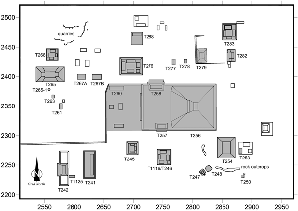
Investigations in 2011 and 2012 in the North-Central sector of Tayasal have uncovered a Late Postclassic shrine, T247, similar to the ones described by Diego de Landa and identified through archaeological survey by Russell at the site of Mayapan. This research was conducted by the North-Central Tayasal Archaeological Project (Halperin Reference Halperin, Pugh and Sánchez Polo2011, Reference Halperin, Pugh and Sánchez2012, Reference Halperin2014), a subproject of the Tayasal Archaeological Project directed by Dr. Timothy Pugh, Lic. José Rómulo Sánchez (2011 field season) and Lic. Carlos Sánchez Góngora (2012 field season). Investigations focused on a 500 x 300 m zone within the eastern part of the North-Central sector of Tayasal (Figures 3, 4).
Map of North-Central Tayasal showing all excavated groups (shaded in gray and labeled).

Postclassic Settlement
Test pitting and horizontal excavations reveal that the small shrine, T247, in the North-Central sector of Tayasal is the easternmost building at the site with Postclassic period construction fill (Figures 3, 4). The North-Central Tayasal Archaeological Project excavations sampled the entire spectrum of architectural group sizes, representing a 32% sample coverage of the total identified structures in the 300 x 500 m zone (n = 62; Figure 4b). Excavations included either a single vertical text pit (1 x 1 m) or a vertical test pit combined with horizontal excavations. This study, when combined with earlier test-pitting investigations by the University of Pennsylvania (Chase Reference Chase1983), represents a 45% sample coverage of identified buildings from North-Central Tayasal (Figure 3).
These investigations indicate that T247 is not only the easternmost building with evidence of Postclassic period construction, but that it is the only one within this study zone with evidence of Postclassic period construction. Some Postclassic ceramic artifacts, however, were recovered on the ground surface of the Preclassic triadic pyramid group, T257, T256, and T258, which was in ruins in the Postclassic period similar to the rest of the buildings surrounding it (Halperin Reference Halperin2014). No Postclassic architectural modifications were made to this pyramid complex or the other buildings in this sector.
As mentioned earlier, excavations beyond this study area by the University of Pennsylvania (Chase Reference Chase1983, Reference Chase, Chase and Rice1985) reveal that Postclassic period occupation at Tayasal was concentrated primarily along the coastal edges of the peninsula (Figure 3). Subsequent work by the Tayasal Archaeological Project (Pugh et al. Reference Pugh, Sánchez and Shiratori2012) as well as by Fredy Ramírez Baldizón (Reference Ramírez Baldizón2004) have uncovered more substantial occupation of the higher elevation zone in the center of the peninsula than previously identified. This Postclassic occupation concentrates within the main group of the site. Furthermore, test-pitting excavations just southeast of T247 and T248 in an area of Tayasal known as “Las Champas” by the Tayasal Archaeological Project in 2009 revealed no Postclassic occupation. Although no excavations have been conducted at the neighboring settlement of El Joboito, the closest settlement just east of Tayasal, extensive excavations at the site of Yaxhul by Jorge Chacon in 2011 (personal communication 2011) did not uncover any Postclassic period occupation (Figure 1). Thus, east of the North-Central Sector of Tayasal, Postclassic settlement appears to either dissipate or disappear completely.
Shrine T247
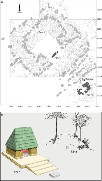
Excavations of Structure T247 reveal that its architectural configuration is most similar to raised shrines found within ceremonial groups (Figure 5). It is a small, 5 x 6.5 m, one-room building that is raised at a height of approximately 1 m above the ground surface by a small platform 8 x 6.5 m in size. Fronting the building was a set of outset stairs with low steps approximately 30 cm apart from one another. The interior room contained a low, L-shaped bench against the back wall. The building and platform were constructed largely from irregular-sized limestone cobbles and relatively few cut stones.
a) Plan map of Structure T247 showing the locations of a small monument, T247-1, and an altar T247-2; b) reconstruction drawing of Structure T247 and Mound T248 (drawing by Luis F. Luin).

Interestingly, the building and its platform were oriented to the intercardinal directions, approximately 42° east of north. Although this orientation is relatively rare for Postclassic raised shrines, such a pattern has been identified at the small central platform at Chan (Robin et al. Reference Robin, Meierhoff, Blackmore, Kosakowsky, Novotny and Robin2012), as well as the northern border shrine of Mayapan, Public ritual group 14P-8, documented by Russell (Reference Russell2008).
The building was constructed in two phases, both dating to the Late Postclassic period. The earlier platform had the same orientation as its later phase, although vertical excavations were not extensive enough to identify its full extent. The head of a small jaguar figurine was recovered directly on top of the first phase of architecture, at the center point of the building. As such, it is possible the figurine was placed there as a dedicatory offering for the second building phase (Halperin Reference Halperin2017:Fig.6k).
A small monument, T247-1, sat directly in front of the building's entryway. It was found in fragmentary condition (measuring 56 cm in length, 22 cm in width, 32 cm in height) and likely would have been larger at the time of its original placement. Excavations below the monument reveal that it was propped up with a foundation of two cut stones, and excavations in front of it revealed evidence of burning, in the form of carbon and darkened soil. At the base of the stairs along the center line of the shrine was a small stone altar, T247-2. Like monument T247-1, it was highly fragmentary and found in more than seven different pieces. Originally, it would have measured approximately 132 cm in width, 70 cm in depth, and 22 cm in height.
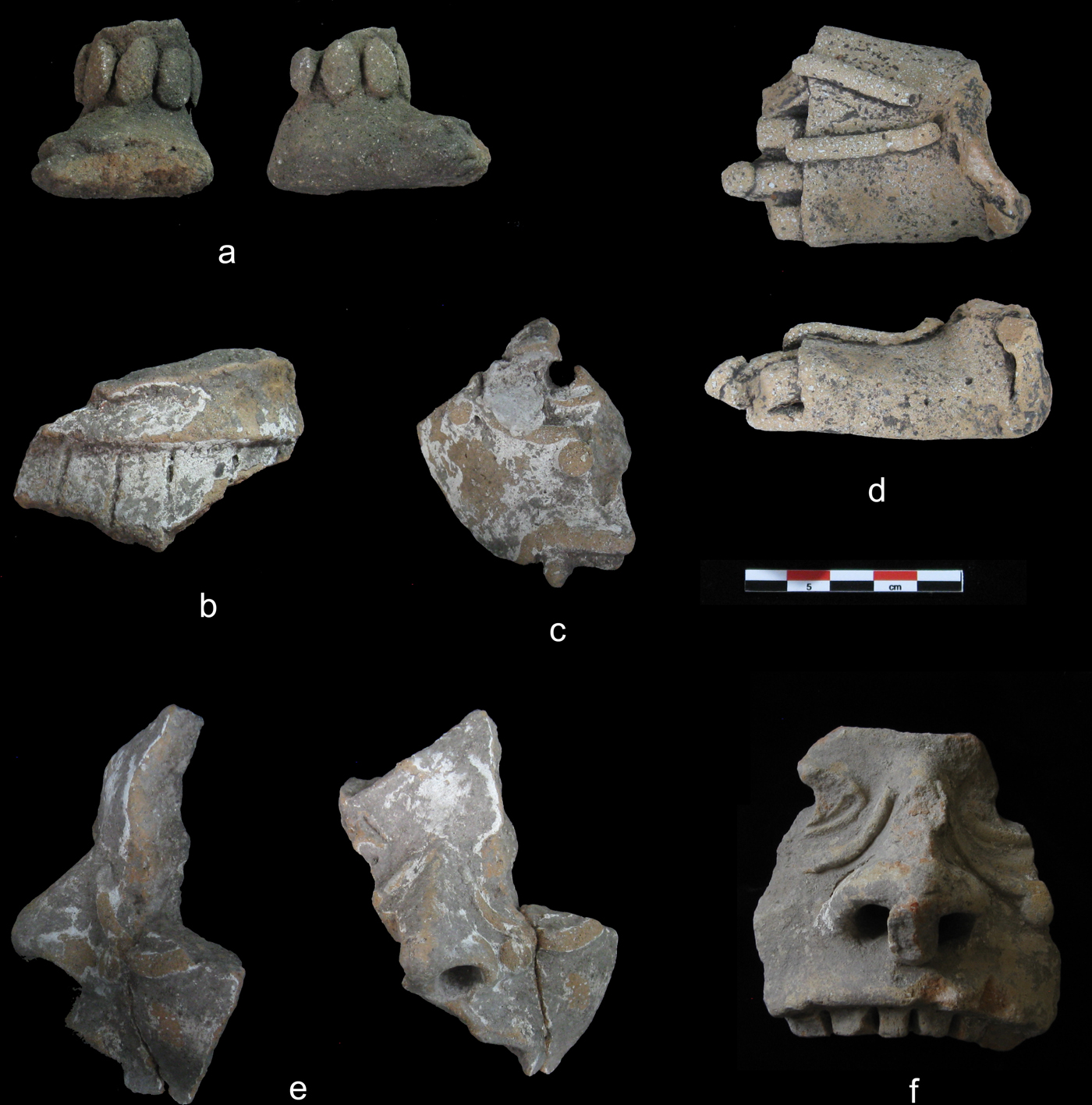
Artifacts were concentrated primarily within the room of the building and at the foot of the stairs by the altar, indicating that these were important foci of religious activity (Figures 6, 7). Artifacts by the altar included Postclassic ceramic censer sherds, Postclassic ceramic vessels, obsidian blades, mammalian faunal remains, and chert debitage. Excavations within the building itself and concentrated along the bench uncovered Postclassic ceramic censer sherds, vessel sherds, a worked and polished quartz crystal bead, chert flakes, obsidian blades, and two small obsidian projectile points. The censer sherds contained both effigy and noneffigy composite types, typically found in the Peten Lakes region (Figure 7; Supplementary Table 1; see Cecil Reference Cecil2001; Rice Reference Rice, Rice and Rice2009 for descriptions of censer types). Some of the effigy censer sherds (Patojo Modeled) were coated in stucco, a treatment also found among censers from Nojpetén (Figure 7f).
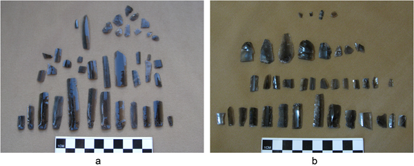
Obsidian debitage and broken prismatic blades from: a) a midden at the edge of the altar, T247-2 (Lot 81104); b) a single excavation lot in the interior room of the shrine, T247, Lot 81108 (photographs by Megan Leight).

Effigy censers recovered within the interior room of the Tayasal shrine, T247 (a–e) and Nojpetén, Flores (f). a) foot, Patojo Modeled type (Lot 81062); b) Patojo Modeled type with white stucco (Lot 81062); c) face fragment, Patojo Modeled type with white stucco (Lot 81102); d) foot, Patojo Modeled type (Lot 81003); e) face fragment, Patojo Modeled type with white stucco (Lot 81062); f) stucco and painted face, Nojpetén, excavated by the Rescate Arqueológico de Isla Flores (All photographs by Christina Halperin).

A total of 200 obsidian artifacts were recovered from the excavations of Structure T247. The density of blades is unusually high and concentrated primarily by the altar and the interior room of the building. Compared with Late Postclassic residential buildings from nearby Zacpeten, which range from 0.239 to 0.834, with an average of 0.626 obsidian pieces per square meter excavated (Pugh Reference Pugh2004:Table 1), the T247 shrine obsidian densities were much higher, at 2.898 obsidian pieces per square meter.
Technological analysis of the obsidian reveals that 65% of all the obsidian artifacts consist of third-series blades, the typical product of blade core reduction (Figure 6; Supplementary Table 2). Forty-two obsidian pieces, or 21% of the sample, was either directly or indirectly related to the production of blades, and 14% of the sample is composed of bipolar-, pressure-, and percussion-made flakes and blades, some of which were transformed into scrapers, points, and knives. The obsidian debitage indicates that blades were produced in the area but not specifically at the shrine. The blades and associated debitage are similar to blades and flakes found in domestic contexts. Nonetheless, the significant concentration of obsidian artifacts located around the altar and interior room may suggest ritual use of the blades for sacrifice, bloodletting, ritual discard, or perhaps even the manufacture of other perishable items, such as idols or wooden god images. Interestingly, unlike some of the other burned remains, such as the ceramic censer fragments and chert artifacts (see below), the obsidian does not appear to have been burned, which suggests they may have been deposited through a separate process.
Small Hill T248
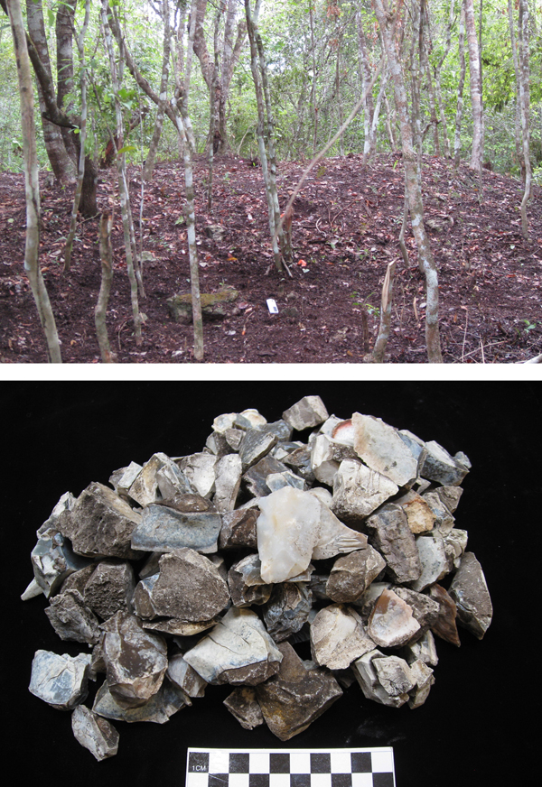
Structure T247 was constructed 2 m from a small hill approximately the same height and size as the raised shrine. The University of Pennsylvania survey (Chase Reference Chase1983) of the site labeled it as a structure, T248, although excavations by the North-Central Tayasal Archaeological Project in 2011 found no evidence of construction features such as architectural fill, collapsed walls, or standing wall alignments. Rather, excavations reached bedrock just under the humus at approximately 10–15 cm below the ground surface. Despite its status as a natural hill, it appears to have been associated with the shrine. Similar to the two altars set up in front of the shrine and granite boulders in the Mountain Pine Ridge (Bullard Reference Bullard1963), Postclassic people had set up a small monument, T248-1, at the southeastern base of the hill, which seemed to parallel the one (T247-1) found in front of the T247 shrine entrance (Figures 5b, 8a). The monument's size (45 cm in width, 28 cm in depth, and 20 cm in height) and placement on several foundation stones were also similar to the one found in front of the T247 shrine. Thus, it provides evidence of modifying natural landforms to replicate shrines, or perhaps of constructing shrines to resemble sacred landforms (Halperin Reference Halperin2014).
Natural hill T248. a) Photograph of the butt end of monument T248-1 in front of natural hill before excavations; b) sample of burnt and fire-damaged chert from excavations on T248, Lot 81113 (Photographs by Christina Halperin).

The nature of activities on the hill, however, appeared to have been quite different. Excavations of the feature revealed very little pottery of any kind and only small amounts of obsidian (n = 9; 0.273 obsidian pieces per square meter). Instead, high frequencies of chert flakes and nodules were found (n = 748) concentrated around the small monument as well as on top of the hill itself (Figure 8). These chert flakes had undergone extensive burning.
A preliminary analysis reveals that the severe nature of the burning far surpasses that of a hearth or forest fire, and it points to a systematic and emphatic burning with consequent explosion of chert nodules in the shrine context. The burning of chert and obsidian may have been part of serial ritual practices, or perhaps a final termination of the hill as a whole. Chert, like bottle glass, can pop and explode, often in a spectacular manner, which may have added to the drama of the ritual practice, whatever its purpose. Many of the chert flakes and nodules were completely oxidized to whiteness on the surface, and the cortex of some pieces had turned to chalk. In contrast to censing rituals within bowls or incensarios, which were more contained burning episodes, the fire-related events associated with the chert flakes and nodules appears to be much more unruly. The use of debitage in ritual contexts is well attested from the Preclassic to the Postclassic in the Maya area and is often associated with fire symbolism. Flint and obsidian represent different aspects of celestial fire emanating from lightning, the sun, and shooting stars. The Maya and other Mesoamerican cultures may have placed chipped stone in caches to embody these otherworldly forces, of both world creation and destruction, which were often associated with new year ceremonies (Andrieu Reference Andrieu, Bonnardin, Hamon, Lauwers and Quilliec2009; Hruby Reference Hruby, Hruby and Flad2007, Reference Hruby, Garrison and Houston2018; Hruby and Rich Reference Hruby, Rich, Navarro Farr and Rich2014).
Conclusion
For the ancient Maya, the intersection between settled and unsettled space was likely a culturally significant point of transition. Although such boundaries were constantly changing over time and were not always marked by human-modified features, growing research suggests that, in some cases, precolumbian peoples constructed small shrines at the edges of their settlements to serve as reference points in the designation of place. Similar to Inka huacas and rural Greek sanctuaries from the Classical period, such places were reproduced through ritual visits and ritual circuits in which centers and peripheries were embodied through movement and circulation and recreated settled space in cosmological and mythic terms (Maca Reference Maca, Robertson, Seibert and Fernandez2006; Taube Reference Taube, Gómez-Pompa, Allen, Fedick and Jimenez-Osornio2003; Vogt Reference Vogt1969).
Based on similar spatial and morphological traits with other border shrines in the Maya area as well as descriptions of such shines, we argue that the T247-T248 complex served as an eastern border shrine during the Late Preclassic period. Although it is possible that northern, western, or southern shrines were also established along the other cardinal directions of the site's boundaries, none have been currently identified archaeologically. The demarcation of the eastern side of the site may have been more pertinent, however, because the site of Tayasal is on a peninsula and surrounded by Lake Petén Itzá on its northern, western, and southern sides. Such limits helped define the divisions between settled and unsettled spaces of the Tayasal community, rather than demarcate political territories, given that Tayasal was likely incorporated into the political and ethnic affiliations of the capital center of Nojpeten and had shifting ties with other settlements beyond these sites (Jones Reference Jones1998; Rice and Rice Reference Rice and Rice2018).
One of the defining characteristics of Tayasal's T247 shrine is its intercardinal orientation, a rare building orientation in the Maya area, but shared with the northern border shrine of Mayapan and the more rural wilderness shrine from Chan, Belize. In addition, the association of the T247 shrine with a small hill, T248, created a paired configuration similar to Diego de Landa's descriptions of crude border shrines comprised of two heaps of stones among Yucatecan towns in the sixteenth century as well as an archaeological survey of a twin shrine complex at the eastern gate of the city of Mayapan. It is noteworthy that the shrines documented by Diego de Landa were described as heaps of stones rather than formal buildings, emphasizing the unmodified or rustic nature of these key points of transition in the landscape. At Tayasal, the Late Postclassic inhabitants placed particular emphasis on a fusion of built (T247) and unbuilt spaces (T248), which arguably was a small-scale replication of a larger settlement-level tension between settled and field/wilderness spaces. Maya peoples drew on such juxtapositions elsewhere, both in the main plazas and principal ceremonial spaces of settlements and in remote wilderness locations, such as the Mountain Pine Ridge border shrine, combining a boulder outcrop with a small raised shrine (Bullard Reference Bullard1963). Together, they created a liminal realm, betwixt and between earthly and supernatural realms, humans and deities, as well as quotidian and ritually demarcated time. Thus, it was doubly fitting that the Tayasal shrine-hill pair sat not just at the intersection of cosmological realms, but also at the threshold of settlement.
Acknowledgements
Funding for the North-Central Tayasal Archaeology Project was generously provided by the Tuck Fund, the Department of Art and Archaeology, and the program of the Society of Fellows at Princeton University. We are grateful to Tim Pugh and the Tayasal Archaeological Project (supported by NSF Grant BCS 1219646) for their support, logistical help, and use of the TAP total-station. Thanks are extended to Mario Enrique Zetina Aldana and Yovanny Hernandez from the Rescate Arqueológico de Isla Flores for permitting Halperin to examine and photograph some of the Flores ceramic material. We would also like to thank the many staff, students, and workers who helped with survey, excavations, and laboratory analysis, including Mirim Salas, Jerson Suarez, Megan Leight, Carlos Alonzo Ramos, Grace Chu, Bryon Hernandez, Elliot Lopez-Finn, Miguel Angel Cano, Sammy Kin Sum Li, and Rose-Anne Bigué. Dedication in memory of Karl J. Lorenzen, Mesoamercanist and specialist in Maya shrines.
Data Availability Statement
Physical data (artifacts) are stored by the Proyecto Tayasal Archaeology Project in Flores, Guatemala and the Instituto de Antropologia e Historia de Guatemala (IDEAH) in Guatemala City. Digital materials pertaining to the North-Central Tayasal Archeological Project are curated and available in the Laboratoire d'Archéologie mésoaméricain in the Department of Anthropology at the Université de Montréal.
Supplemental Materials
For supplementary material accompanying this paper, visit https://doi.org/10.1017/laq.2018.77
Supplementary Table 1. Censer sherds from Tayasal Shrine, T247.
Supplementary Table 2. Obsidian artifacts from T247.