BEDFORDSHIRE
(1) Bedford, Manton Lane (TL 0414 5099): the fifth season of a community project undertaken with the support of Albion Archaeology investigated an area within the grounds of Edith Cavell Primary School. A test-pit revealed mortared and squared blocks supported by (at least) two courses of stone footings which extended into the presumed interior of the building (fig. 13). No in-situ floor surface survived but two stone tesserae were found in the vicinity. Fragments of roof- and flue-tiles and plaster were recovered and are presumed to be associated with this building or another close-by. Other finds included three coins and a bronze spoon.Footnote 47
Manton Lane, Bedford. In-situ stone footings of a Roman dwelling.

(2) Elstow, Wixams Northern Expansion Area (TL 4456 4597): an Iron Age and Roman farmstead was excavated, over an area of c. 3 ha, in advance of construction of an employment park. The mid- to late Iron Age settlement survived until the first century a.d. when its D-shaped and circular enclosures were replaced by more regular and extensive Roman rectilinear enclosure systems with trackways that were occupied into the fourth century (fig. 14). An associated late Roman inhumation cemetery, containing eight graves, was focused on a partially infilled boundary ditch. A high proportion of the burials were of immature individuals and, in one case, three people were simultaneously interred in the same grave. The farmstead also featured a pottery kiln with an integrated tongue pedestal; poorly fired ‘seconds’ from the kiln and a nearby ditch suggest it was used to produce shelly wares.Footnote 48
Wixams. Iron Age and Roman field-systems.

BUCKINGHAMSHIRE
(1) A355, Beaconsfield Eastern Relief Road (SU 9510 9075): a total of 54 trenches, 25 m long and 1.9 m wide, were excavated. In the northern field there was a scatter of undated ditches and probable pits; the absence of finds suggests that this activity was peripheral to settlement. Finds from the north-west end of the site were largely post-medieval except for two flint knives, a whetstone and a couple of small pieces of Roman pottery. Trenches alongside the eastern edge of the northern field contained colluvial layers overlaying natural geology as well as some ditches and a pit. None of the ditches contained dating evidence, but the pit contained small fragments of early Roman pottery, showing that the colluvium here was Roman or later. Archaeological features were more numerous in the central and southern part of the site where concentrations of Roman pottery were found as well as a small piece of possibly Roman window-glass. This area also produced evidence for two enclosures and a charcoal-filled pit.Footnote 49
(2) Aylesbury, Waddesdon to Aylesbury Parkway (SP 74957 16312–SP 78598 15386): detailed gradiometer survey was undertaken of 12 ha of land along a proposed 4.1 km cycle route between Waddesdon Manor and Aylesbury Parkway station. The central part of the route lies along the projected line of Akeman Street. Possible ditches were detected in four areas. At the western extent of the survey, to the east of Wormstone, there was a concentration of linear features which may be associated with a nearby Roman farmstead. To the south-west and south-east of Cranwell Farm, there were several short ditch-like features located in close proximity to the route of the Roman road which may be associated with it. To the west of Fleet Marston, several ditch-like features lay in an area where extensive Romano-British activity has previously been identified.Footnote 50
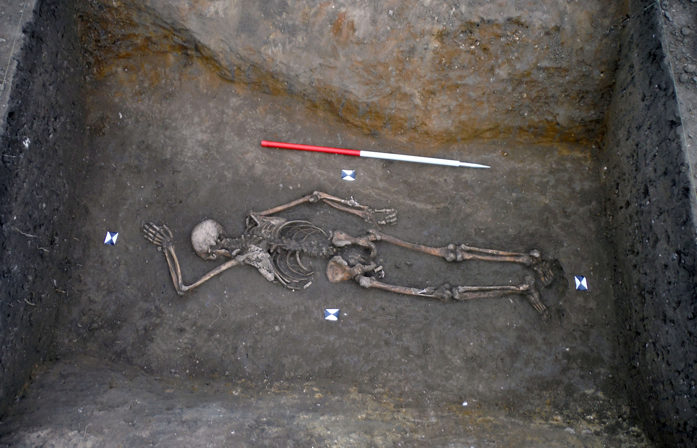
(3) Fenstanton, Cambridge Road (TL 3192 6810): excavation in advance of a 2.5 ha housing development at the southern edge of the village uncovered part of a second- to third-century Roman settlement. Remains comprised pits, ditches and wells, metalled surfaces and buried soils. In addition, the packed-clay footings of a timber building were identified in situ. Two small cemeteries contained 21 graves, many with coffin nails, including a rare bustum (or pyre) burial. A further individual was found lying prone in a ditch (fig. 15). The archaeology seems characteristic of a roadside settlement, though whether the road in question was the Via Devana, on whose approximate route the settlement lies, is uncertain. The recovery of a horse and rider brooch and part of a votive model altar may indicate the nearby presence of a shrine or temple.Footnote 51
Fenstanton. Prone burial in a ditch.

(4) Longwick, land adjacent to Thame Road (SP 7875 0525): archaeological evaluation followed by excavation of sixteen 25 m by 1.8 m trenches. The results of the excavation revealed part of a possible Roman trackway orientated NNW–SSE, which may have linked to the Lower Icknield Way (a prehistoric and Roman trackway) to the south. This trackway was formed by two ditches 10 m apart which contained Roman ceramic building material and pottery. One of these ditches appeared to be the same as the ditch found during the evaluation where pottery was found dating to the second or third century.Footnote 52
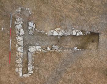
(5) Milton Keynes, Campbell Park, land east of Overgate and west of the Grand Union Canal (SP 8680 3945): c. 0.8 ha of open-area excavation in advance of development revealed remnants of a late Iron Age to early Roman rectilinear field-system and second- to third-century crop-processing. Two limestone-block drying ovens and two limestone slab floors were recorded. One of the drying ovens was T-shaped (fig. 16), while the other was key-hole shaped (fig. 17). The floors (fig. 18) were located downslope in an area prone to flooding. Their damp location combined with their construction, whereby the sides and base of the larger floors were surrounded by a thick clay lining, suggests they may have been malting tanks rather than threshing floors. Features characteristic of domestic settlement were revealed, with modest pottery and animal bone assemblages and two infant burials found.Footnote 53
Campbell Park, Milton Keynes. T-shaped drying-oven.

Campbell Park, Milton Keynes. Key-hole-shaped drying-oven.

Campbell Park, Milton Keynes. Sunken stone floor for crop processing.

(6) Milton Keynes, land at Eaton Leys (SP 88942 33168): evaluation identified features of late Iron Age to early Roman date 330 m south of the Roman settlement of Magiovinium.Footnote 54 Two trackways running south from the settlement were adjoined by a series of enclosures. Quarry pits, ditches and pits containing domestic waste were also identified, as were nine dispersed cremation burials, possibly associated with a previously recorded early to mid-Roman cremation.Footnote 55
CAMBRIDGESHIRE
(1) Doddington, Wimblington Road (TL 4051 9081): excavation confirmed the presence of later Iron Age and Roman field-systems which had previously been identified by geophysical survey and archaeological evaluation.Footnote 56 Also found was a remnant of Roman land surface, a large sub-rectangular pit, a possible well and two rectangular post-hole buildings. Activity was most intense in the first and second centuries, with the bulk of the finds, including 1,206 pieces of Iron Age and/or Roman pottery, pre-dating a.d. 150. A small amount of later Roman pottery was also recorded associated with the maintenance of an eroding field-system.Footnote 57
(2) Ellington, land west of Brook Farm, Thrapston Road (TL 1550 7210): excavation (0.8 ha) of a later Roman trackway and associated enclosures. The trackway extended across the width of the site and had been recut and redefined on several occasions. Of particular interest were two complete, deliberately placed, fourth-century pots deposited in one of the trackway ditches. Evidence of iron-smithing was focused in the north-eastern area of the site; slag, flake hammerscale and smithing hearth bottoms were recorded. Evidence from the environmental remains and quernstones point towards on-site cereal processing. An in-situ Roman subsoil also survived in the north-east of the site, into which several later Roman ditches had been cut, which contained quantities of pottery and animal bone. A small but significant assemblage of later fourth-century Roman coins was recovered, suggesting activity may have continued into the early fifth century.Footnote 58
(3) Ely: (a) Field D, North-West Ely, Phase 2 (TL 5460 8230): the central and northern parts of the excavation area contained Roman features comprising parallel cultivation strips or lazy beds, laid out to the east of a trackway. The trackway was orientated north-east to south-west and was formed by two parallel ditches, spaced roughly 10 m apart. Initial post-excavation research indicates that this trackway was aligned with the route of Akeman Street. The interior of the Roman track and a contemporary small enclosure were subsequently used as cemeteries in the early Saxon period.Footnote 59 (b) Land north of Cam Drive, North-West Ely (TL 54385 81770): excavation revealed early Roman field-systems, midden spreads and pits as well as a very shallow grave containing the remains of five individuals. Analysis indicates that this settlement ended during the second century.Footnote 60
(4) March, land at Jobs Lane (TL 4153 9493): excavation identified part of a mid-to-late Roman settlement which included an extensive network of ditches and pits. The ditches formed a complex of parallel boundaries in the western part of the site delineating differing activity types, whilst in the eastern part of the site they made up multiple phases of enclosures of varying sizes. A large number of pits was identified with many containing significant assemblages of pottery; moreover some of the pits appeared to have an industrial character as they contained burnt material. Associated with these pits were four watering-holes which would have provided water for the settlement and associated industrial activities. Four small ovens were excavated; these varied in size and shape, possibly indicating different phases of activity or differing uses.Footnote 61
(5) Peterborough, land at Paston Reserve (TF 1979 0298): excavations identified Roman agrarian activity located c. 50 m south of the Car Dyke. The recorded features comprised a series of short ditch segments from a larger field-system, which had at least two phases of alignment indicating extended use. A number of pits were identified, some of which contained a large assemblage of pottery. Contemporary with these pits were two watering-holes which would have been the water source for the farmstead. Three pits excavated on the site contained large quantities of charcoal and evidence for burning; however, no evidence for in-situ fires was present. One pit contained an assemblage of slag indicating iron manufacture nearby.Footnote 62
DERBYSHIRE
(1) Eckington, Staveley Lane (SK 4292 7874): an excavation investigated part of a rural Roman settlement, situated within a large curvilinear enclosure ditch. The settlement was occupied from the late Iron Age or early Roman period until c. a.d. 200, but had been substantially truncated by later activity.Footnote 63
(2) Whaley Bridge, land off Linglongs Road (SK 00670 80470): evaluation exposed an undated trackway consisting of a raised embankment over 4.2 m wide (the full width is not known due to truncation) and 1.1 m high. A rough stone surface possibly replaced an earlier stone surface and may speculatively represent later maintenance of a route with earlier origins. The observed details of the trackway are consistent with a Roman road on a raised agger.Footnote 64
HERTFORDSHIRE
(1) Hemel Hempstead, Maylands (centred TL 1836 0764): excavation subsequent to an extensive evaluation examined two adjacent areas covering a total of just under 2.5 ha. In the larger area, to the west, the principal feature was a fairly poorly preserved tile kiln (6 m by 9.2 m), built of tile and flint and aligned roughly north–south, set within a sub-circular enclosure defined by two separate semi-circular gullies, a southern arc with an internal diameter of 20 m and a northern arc with an internal diameter of 15 m. The area surrounding the kiln, both inside and outside the gullies, was covered with large charcoal spreads. The area was surrounded by a number of large pits, presumably for clay extraction.
A simple T-shaped corn-drying oven lay just north of the kiln installation, with two further such ovens 15–20 m further north. An L-shaped ditched boundary, aligned WNW–ESE and then NNE–SSW, separated the kiln and adjacent oven from the other two ovens, but the relative chronology of these features is uncertain. Further ditched boundaries to the north and east were on both comparable and contrasting alignments.
In the smaller excavation area to the east the principal feature was a double chambered lime kiln, built in a large hollow or pit facing north-west. The lower parts of the approximately circular chambers consisted of roughly conical pits dug about 0.9 m into the chalk, above which brick and tile walls defined the upper parts of the chambers, both c. 2.5 m in internal diameter. Each chamber had a separate flue, but they were linked by a gap 0.9 m wide behind the facade of the structure. The brick and tile was in a consistent fabric, the material including a number of tegulae mammatae. The walls were bonded and their interior faces skimmed with clay; they survived to a maximum height of c. 1 m. The lower parts of the chambers were filled with chalk rubble.
There was almost no dating evidence associated with the lime kilns. Pottery elsewhere dated mainly to the first and second centuries. The principal structures are likely to have been associated with the construction of the well-known adjacent temple-mausoleum complex at Wood Lane End.Footnote 65 The tile kiln lay only c. 80 m south of the probable southern corner of the enclosure of that complex, while the lime kilns were situated c. 205 m east of the same point. It is likely that the tile kiln was used to produce material both for the temple-mausoleum complex and for the lime kilns, as part of a single construction operation. In a later phase the tile kiln may have been modified for use as another corn-drying oven, suggesting development of the area for agricultural processing after the construction of the religious complex, probably in the early second century. The complex was out of use by the end of that century. The lack of late Roman material from the present site is consistent with this date range.Footnote 66
LEICESTERSHIRE
(1) Market Harborough, Manor Farm (SP 719 876): the continuation of an extensive open-area excavation in advance of residential development revealed an early Roman farmstead, overlying an unenclosed Iron Age settlement.Footnote 67 The farmstead was more extensive than its Iron Age predecessor; it covered 2.6 ha, although its settlement core occupied a quarter of that area (fig. 19). No later Roman artefacts were found and it is presumed that settlement had ceased by the mid-third century.Footnote 68
Manor Farm, Market Harborough. Plan of the early Roman settlement.

NORTHAMPTONSHIRE
(1) Broughton, Buckton Field West (SP 7408 6508): archaeological evaluation comprised 41 trenches. Evidence for occupation during the later Iron Age and into the early and middle Roman periods was extensive and took the form of an array of ditches and pits focused on the central and western parts of the evaluated area. The pottery from several of these features was unabraded, suggesting that it was deposited in the vicinity of settlement areas. The presence of imported pottery suggests a site of at least moderate status. Fired clay derived from a domestic oven or crop-processing drier, and also possibly from a metal-working furnace, was present, as were the remains of fallow deer, which are very rare from Romano-British contexts. The presence of axially split cattle bones in Roman contexts may indicate that specialist butchery was carried out within the site. Waterlogged material of probable Roman date was present in a lower lying area within the south-western part of the site. Several trenches contained closely spaced parallel ditches, which did not have the form of medieval or later plough furrows. These were present on several alignments, and where dated, contained Roman material. These could represent arable cultivation of Roman date.Footnote 69
(2) Daventry (SP 5900 6400): a 70-trench evaluation of a 247 ha site to the north-east of Daventry. The southern part of the site in Field 1 revealed evidence of a Roman rural settlement dating to the second and third centuries. Trial-trenches exposed numerous ditches, probably relating to enclosures and other field boundaries. The most significant find was a stone-lined corndrier with well-preserved environmental remains deposited in its flue. Preliminary analysis of this material suggests that the corndrier was used to malt cereal grain, possibly for ale production. A relatively high quantity of pottery from the site suggests that domestic activity was fairly intensive, while the recovery of cattle, sheep and horse bones indicates that the settlement operated a mixed agricultural economy.
The settlement was located close to the foot of Borough Hill, an Iron Age hillfort that was refortified at its northern end. A Roman villa dating from the second to fourth centuries was built within this enclosure; a second-century barrow cemetery was located to its south in the middle of the hillfort. The site also lies c. 3 km west of the Roman town of Bannaventa located on Watling Street.Footnote 70
(3) Kettering, Kettering sewage routing (SP 901 741): emergency excavation was undertaken of a double burial uncovered during service works for an Anglian Water pumping station on a new pipeline on the outskirts of Kettering. Previous archaeological work had shown that there was Romano-British occupation in the area. The burial comprised two partial skeletons, one with significant head trauma, which was likely to have been the cause of death. Both skeletons were buried within a small pit suggesting the individuals were killed or executed and then dumped into the feature. The burials have been radiocarbon dated to 80–237 cal. a.d.Footnote 71
(4) Thrapston, land off Huntingdon Road (TL 0011 7812): open-area excavation in advance of residential development on the eastern outskirts of the town uncovered multi-period remains. The landscape was transformed in the Roman period, with earlier field boundaries abandoned and replaced by a field-system on a completely different alignment. One unusual aspect of the Roman remains was the survival of evidence for approximately twelve post-built rectangular buildings up to 13.5 m by 6 m in size. A number of large pits were presumably dug to quarry clay and limestone for building work. A modest finds assemblage included several coins, a quernstone and a copper-alloy toilet spoon. It is possible that the settlement was occupied on a short-term or even seasonal basis, possibly linked to the quarrying.Footnote 72
NOTTINGHAMSHIRE
(1) Scrooby, Scrooby South Quarry (Stage 2) (SK 65500 89440): strip, map and record excavation found a relict field-system which constitutes a fragment of a much larger landscape of settlement and enclosure. Some evidence of recutting and superimposition of boundaries was recorded, suggesting a degree of time-depth to the remains, and belying the apparent ‘simplicity’ of the field-system when viewed from the air. Romano-British roof-tile was found redeposited in later contexts in two separate parts of the site. This suggests that the remains of a building of higher status and more ‘Romanised’ form than hitherto encountered in the Scrooby landscape may lie nearby.Footnote 73
OXFORDSHIRE
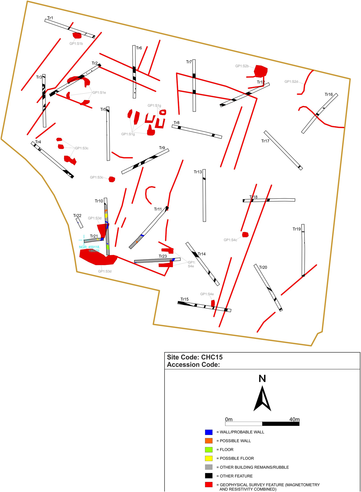
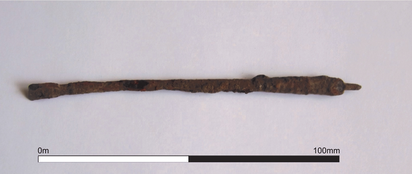
(1) Cholsey, land off Celsea Place (SU 591 861 centred): 23 evaluation trenches and geophysical surveyFootnote 74 (fig. 20) revealed a substantial rectangular Roman building (aligned north-west–south-east) in the south-west corner of the site. The structure was probably the northernmost element of a farm or villa complex, which possibly extended to the south and south-west of the site. External and internal walls and at least one floor surface were recorded. Significant amounts of box-flue tile suggest a hypocaust heating system, which, along with the presence of tegula, imbrex, painted wall-plaster fragments and a Roman stylus (fig. 21), indicates the building was well appointed and its inhabitants literate. Outside the area of the building, ditches, pits, post-holes and other cut features were recorded. The ditches probably represented multiple phases of linear boundaries, enclosures and possible droveways. The features outside the area of the Roman building appeared to be largely agricultural in nature, although the occurrence of a piece of possible slag and fired clay hinted at localised industrial activity and the geophysical survey suggested the presence of a possible kiln.Footnote 75
Cholsey. Evaluation trenches in relation to geophysical survey results.

Cholsey. Iron stylus.

(2) Dorchester on Thames, allotments (SP 5773 9410): a further season of the Oxford University/Oxford Archaeology Training Excavation.Footnote 76 A few small features and a more substantial west–east ditch examined in the western part of the site were broadly dated to the middle of the first century a.d. South of the ditch a deep (c. 1 m+) vertical-sided pit, cut by a large later pit (4004, see below), was partly excavated and produced pottery also of mid-to-late first-century date. Individual finds of this broad phase included an unstratified Iron Age coin and a sherd of a terra nigra dish with a stamp of CANICOS, dated c. a.d. 25–50. The early features were overlain by a widespread deposit of clayey loam up to c. 0.25–0.30 m thick, which appears to date to the later first century.
In the second century the central part of the site was occupied by a complex of large pits. The largest of these (feature 4004, roughly 8 m by 6 m) in the south part of this area was roughly vertical-sided and had a maximum depth of c. 1.85 m. The lower fills were not particularly finds-rich, but the middle part of the fill sequence produced substantial quantities of second-century finds.
North of pit 4004, a complex sequence of layers was shown to overlie, or perhaps represent the very final stages of, a sequence of further large intercutting pits. Parts of several of these were excavated and appear to date to the second century. In the extreme south-west corner of the site part of the northern edge of another large feature, more likely another pit than a linear feature, produced another substantial finds assemblage mostly of second-century date.
In the eastern part of the site, three sections were excavated through the Roman road. A pre-road context, which produced a coin of a.d. 72–3, was overlain by a complex series of deposits. Evidence for definition of the western margin of the road was uncertain, except when it involved adjacent linear features, which included traces of a probable roadside cob wall. In addition, probable beam-slots were located in one of the three sections, and a tightly packed east–west cluster of c. 20 large stake-holes in another, lying just east of the line of the probable cob wall. The interpretation of these structural elements is not yet clear.Footnote 77
(3) Faringdon, Coxwell Road (SU 278 944): an excavation of 2.1 ha revealed part of a settlement of late Iron Age to early Roman date with two main phases of activity; areas of industrial and settlement activity were defined by ditches forming rectangular enclosures. Most of the fairly large pottery assemblage is contemporary with the settlement; only small amounts of animal bone, ceramic building material and metalwork were found.
The earliest enclosed area was situated in the north-west of the site; defined by a ditch on two sides, it continued to the west of the excavation boundary. No dating material was found in this ditch and there were no features within the enclosure but excavation showed that other ditches had been cut through it. Overlying this was a system of ditches laid out on a north-east–south-west and north-west–south-east alignment defining at least three larger areas in the north-west of the site and eight or nine smaller ones in the south-east. The ditches in the north-west contained smaller amounts of pottery suggesting this area was away from the main focus of the settlement. There were also fewer other features here suggesting these areas may have been used as stock enclosures or small fields.
The eastern part of the site revealed three enclosed areas. One contained the remains of a roundhouse gully and one contained a well, a corndrier and the remains of another possible building that had been backfilled with domestic refuse including large amounts of pottery and some worked stone blocks.
The central area of the site appears to have been the focus of activity even though the only remains of buildings were dumps of rubble and a few post-holes. There was a trackway leading into this area from the direction of Coxwell Road. There were also rubbish pits with a large amount of pottery and another well suggesting that there had been houses nearby.Footnote 78
(4) Oxford, Barton Park (SP 5450 0830): an excavation west of Barton Park on the outskirts of the City of Oxford. The excavated features comprised the remains of Romano-British and later field-systems including rectilinear enclosures and possible droveways, perhaps representing a number of sequential attempts to cultivate an area of poor and frequently waterlogged land. The pottery assemblage from the site was paltry, comprising little more than 40 identifiable sherds of Roman or medieval date. There were, however, some notable isolated finds, including an early Roman cremation burial and a single first-century a.d. Roman coin.Footnote 79
(5) South Leigh, Gill Mill New Quarry (centred SP 372 081): excavation in three different areas of Gill Mill Quarry.Footnote 80 At the north-west end of the quarry further work was undertaken in adjacent Areas 2A (centred SP 3630 0835) and 2B (centred SP 3640 0815), adjoining the south side of the part of Area 2A examined in 2016. In total an area of c. 5.27 ha was stripped. This lay entirely within a zone suggested by an earlier geophysical survey to be occupied by relict channels of the eastern arm of the river Windrush. A small palaeochannel section was recorded and sampled for environmental remains in Area 2B but there were no archaeological features or finds.
Area 3, adjoining these areas to the east (centred SP 366 084), which aerial photographs and geophysical survey suggested contained an extensive area of settlement, was subject to evaluation by 39 trenches, each 30 m by 2 m. The principal settlement focus (centred c. SP 3655 0840) was continuously occupied from the middle Iron Age (possibly no earlier than c. 200 b.c.) up to the early Roman period.
A late Iron Age to early Roman settlement overlay a middle Iron Age predecessor, but in addition occupation of this period extended further to the south-east and was also encountered in the north-east half of Area 3, where a small ring-gully and a post-built structure were recorded. The main elements of the late Iron Age to early Roman settlement were again boundary and enclosure ditches. More pottery was dated to this period (380 out of a site total of 567 sherds); this suggests that the settlement went out of use by c. a.d. 100.
In Area 5A, at the south-east end of the quarry, an area of c. 2.49 ha (centred SP 378 075) was subject to strip, map and sample excavation. A north-east–south-west-aligned Roman ditch was a continuation of a feature examined in 2015, the known length of which is now in excess of 250 m. No other certain Roman features were identified.Footnote 81
(6) Stoke Lyne I: a hoard of 1,691 radiates, deposited a.d. 274 or later in a fine greyware vessel; disturbed by the plough, it was found with a metal-detector and recovered in a controlled excavation.Footnote 82 Contents: joint reign of Valerian and Gallienus, 12 (Valerian, 7; Salonina, 5); Gallienus (sole reign), 149; Salonina (sole reign), 14; Claudius II, 152; Divus Claudius II, 6; Quintillus, 9; Aurelian (pre-reform), 3; Postumus, 36; Marius, 2; Victorinus, 309; Divus Victorinus, 1; Tetricus I, 561; Tetricus II, 297; uncertain Gallic emperor, 22; uncertain emperor, 12; irregular, 106.Footnote 83
(7) Stoke Lyne II: a hoard of 395 radiates, deposited a.d. 271 or later in a colour-coated ware vessel; disturbed by the plough, it was found with a metal-detector and recovered in a controlled excavation.Footnote 84 An additional scatter of 193 radiates thought to be from either Stoke Lyne I or II (along with stray coins) was also catalogued.
Main hoard: Trajan Decius, 1; Volusian, 1; joint reign of Valerian and Gallienus, 40 (Valerian, 12; Gallienus, 17; Salonina, 7; Saloninus, 1; Valerian II, 1; Divus Valerianus, 2); Gallienus (sole reign), 41; Salonina (sole reign), 5; Claudius II, 26; Quintillus, 2; Postumus, 135; Laelian, 2; Marius, 3; Victorinus, 137; uncertain emperor, 2; stray nummi, 2.
Scatter: Trajan Decius, 1; joint reign of Valerian and Gallienus, 15 (Valerian, 7; Gallienus, 3; Salonina, 2; Saloninus, 3); Gallienus (sole reign), 25; Salonina (sole reign), 2; Claudius II, 14; Quintillus, 1; Postumus, 55; Victorinus, 63; Tetricus I, 4; Tetricus II, 5; uncertain emperor, 1; irregular, 7; Carausius, 1; Allectus, 1; stray nummi, 37; siliqua, 1.Footnote 85
(8) Sutton Courtenay, Sutton Courtenay Lane (SU 5034 9237): a trial-trench evaluation of 23 trenches within the waste ground surrounding the derelict warehouses on the site. Due to restrictions caused by ground contamination, 11 of the excavated trenches were either wholly or partially abandoned.
The results of the evaluation demonstrated a high level of archaeological activity in the north-west of the proposed development. Concentrations of prehistoric and Roman remains, including large settlement enclosure ditches, were identified in Trenches 6–15. This activity appears to represent a distinct complex of linear and curvilinear enclosure ditches, smaller boundary ditches and discreet features comprising pits, gullies and post-holes. The frequency of intercutting features, particularly of the enclosure ditches, was representative of a multi-phase settlement, where the re-establishment of boundaries was clearly evident. This settlement spanned the late Iron Age to late Roman periods.
The pottery assemblages dated to the middle Iron Age were concentrated in Trenches 7, 8, 9 and 11 in the north-west corner of the site, while the late Roman groups were recovered from Trenches 6, 10, 11, 13 and 14, also in the north-west corner of the site, but extending further east; this may indicate a shift in settlement focus through time at the site. Cropmarks identified immediately to the north clearly show the settlement continuing outside of the site boundary and indicate a large rectangular enclosure with internal small rectangular and circular divisions surrounded by field-systems and animal enclosures.
A single coin of Constantine II (a.d. 337–40) was found within one of the enclosure ditches. Two decorated weaving combs provide evidence for the production of domestic textiles at the site. A fragment of worked antler also indicates bone-working was being carried out in the vicinity. Furthermore, the environmental sampling in this area of the site produced charred remains and animal bones indicative of arable farming and settlement activity within the vicinity. Fired clay fragments interpreted as oven structure were also recovered.Footnote 86
SHROPSHIRE
(1) Pattingham: a hoard deposited c. a.d. 272‒4 or later. Contents: 283 radiates: joint reign of Valerian and Gallienus (Salonina), 2; Gallienus (sole reign), 22; Salonina (sole reign), 4; Claudius II, 24; Divus Claudius II, 5; Quintillus, 4; Postumus, 2; Marius, 1; Victorinus, 14; Tetricus I, 9; Tetricus II, 15; uncertain Gallic emperor, 42; irregular, 28; illegible, 111.Footnote 87
STAFFORDSHIRE
(1) Alrewas, Whitemoor Haye Quarry (SK 17737 12314): a programme of archaeological investigation comprising successive areas of excavation and watching-brief was completed in advance of gravel extraction between 2005 and 2012. These investigations identified activity from later Mesolithic to middle Neolithic date through to more substantial settlement activity dating from the middle Bronze Age to the Roman period (third century). The settlements all appeared to have been engaged in pastoral agricultural activity.
During the Romano-British period landscape boundaries providing grazing and droveways were maintained, whilst there was also some creation of new field-systems and trackways. Two Roman roundhouse structures have been identified at the site, with double entrances. The first had a ring-gully with a diameter of 8.35 m (internal) and entrances facing north-west and south-east. This ring-gully contained significant quantities of late second- to early third-century pottery. Inside the ring-gully were a number of pits and post-holes that although mostly undated, are likely to reflect internal supports and possible storage features. In particular, a rectangular group of post-holes may represent the base of a loom or other internal domestic/craft structure. The second smaller roundhouse, with a diameter of 6 m (internal), although undated, has been placed in the Romano-British phase of activity due to its proximity to the first roundhouse and its similar morphology, with two entrances to north-east and south-east. Again, pits and post-holes inside the gully are interpreted as internal partitions and storage areas. Roundhouses with double entrances are rare and account for only 3 per cent of known structures.
The site also contained a 24-post rectilinear building, aligned north to south, which measured 8.3 m long and 5.48 m wide (internal). Two entrances were recorded; the larger (2.3 m wide) survived on the western wall and the smaller (1.2 m wide) on the eastern wall. This structure had an internal partition represented by a post-hole and beam-slot, but no contemporary internal features or hearths survived.
Within the field-systems, a Roman clay-lined oven was recorded which consisted of two shallow parallel flues leading to a shallow pit at their eastern end. The flues were backfilled with charcoal and fired clay fragments thought to be collapsed superstructure.Footnote 88
WARWICKSHIRE
(1) Radford Semele, Spring Lane (SP 34215 64219): archaeological excavation in advance of a proposed residential development uncovered part of a ditched boundary aligned north–south, with a return on the east side and an entrance, confirming the results of a previous geophysical survey. The features are likely to form part of a field-system dating from the late Iron Age to early Roman period, probably associated with an unidentified settlement located somewhere in the vicinity. The paucity of artefactual evidence suggests that the settlement was not particularly close.Footnote 89
WORCESTERSHIRE
(1) Bredon, Oak Lane (SO 9250 3670): an excavation identified the remains of a Roman farmstead which comprised a probable roundhouse and a well, surrounded by enclosures. The finds assemblage revealed that these were occupied from the first to the late third/fourth centuries, with abandonment having occurred by the early fourth century. The skeletal remains of one human and several dogs, as well as a number of cremation urns and three well-preserved leather shoes, were retrieved from the well, most likely representing a deliberate symbolic closure of the feature when the settlement was abandoned.Footnote 90
SUPPLEMENTARY MATERIAL: CONTENTS
For Supplementary Material for this article please visit https://doi.org/10.1017/S0068113X1800034X