

INTRODUCTION
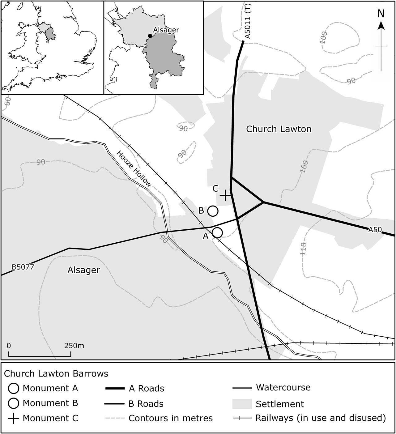
The excavation of the Church Lawton barrows is without question one of the most important investigations of an Early Bronze Age monument complex in the northern part of the western midlands of England. The excavation was prompted by concerns about the preservation of these features, which were visible as low degraded mounds (Barrow A at SJ 8085 5573 and Barrow B at SJ 8083 5582) in fields on either side of the B5077 to the east of Alsager (Fig. 1), and located 2 km from the boundary between Cheshire and Staffordshire. A third barrow, C, (at SJ 8089 5592) a short distance to the north-east of Barrow B, was destroyed by the expansion of a petrol garage and vehicle service station in the late 1950s. This barrow was not investigated prior to its destruction.
Site location. The counties of Cheshire and Staffordshire are depicted in the inset maps. Illustration produced by Rob Edwards (Shared Services, Cheshire West & Chester Council & Cheshire East Council) (Ordnance Survey data © Crown Copyright & database right 2014. Ordnance Survey 100049045)

The presence of a mound equating to Barrow B has long been recognised and is indicated by ‘roundabout’ as a fieldname in the tithe apportionment for Church Lawton (1842). Later, the Ordnance Survey reported that ‘urns, etc’ had been found at the site (Ordnance Survey 1876; Tomlinson 1882), but no detailed information relating to their discovery is known to exist and the urns cannot be located. It was noticed during the excavation of this monument that there was little evidence of Victorian exploration (McNeil Reference McNeil1982a, 46) and hence it is possible that much, if not all, the reported material came from Barrow C. There are also apparently local accounts of bones having been found in the area when the cutting for the railway line to the west was dug (ibid.).
The excavation of the Barrows A and B (referred to by the excavator as Church Lawton South and North, respectively (McNeil Reference McNeil1982a; Reference McNeil1982b), and hereafter referred to as Monuments A and B) was undertaken over an 8-month period from July 1982 to February 1983. The condition of Monument A was found to be reasonably good. Some damage had occurred from tree growth, indicated by shallow pits in the northern part of the site, and from ploughing. In addition, earth from the cutting of the railway line had been dumped over the western part of the mound. Despite having been partially degraded by ploughing, Monument B was also found, on excavation, to be relatively well-preserved.
An open area excavation was conducted on Monument A, which was sub-divided into areas defined by baulks. Virtually the whole of the barrow was examined and all the boulders which surrounded the mound were revealed. Monument B was excavated according to the quadrant method, with baulks left across the mound which provided sectional views of the depositional and constructional sequence. For each monument a separate series of numbers was allocated to layers and features (F) – in this report numbers allocated to deposits are shown in square brackets. In addition, the individual stones forming the ring were given ‘S’ numbers. During the excavation of both monuments ‘small finds’ were plotted three-dimensionally, charcoal was collected for radiocarbon dating, and samples of deposits were taken for environmental analysis.
Following the excavation, the circle of boulders at Monument A appears to have been left in place and covered over, and at Monument B the ground was reinstated to form a low mound, which has helped to preserve the unexcavated parts of the site.
Interim statements on the findings were issued shortly after the excavation was completed (McNeil Reference McNeil1982a; Reference McNeil1982b) and the remains discovered were highlighted by David Longley in his synthesis of the prehistory of Cheshire for the Victoria County History (Longley Reference Longley1987, 61–5, 73, 84). This information was complemented by a series of wide-ranging radiocarbon dates obtained from charcoal samples (plant species were not recorded; Walker et al. Reference Walker, Keysor and Otlet1988, 337–8).
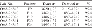
Before Robina McNeil’s untimely death in 2007 a substantial amount of work had been undertaken on preparing a report for publication. Despite the progress made (mainly in the years immediately following the excavation), it fell to the Cheshire Archaeology Planning Advisory Service to provide the funds to complete the task. Constraints on the project, however, have meant that it has been necessary to limit the number of illustrations, including those relating to the stratigraphical and structural sequence. The work carried out by Sam Walsh, as part of her study of Bronze Age burials in northern England (Walsh Reference Walsh2013; Walsh et al. in prep.), has been of crucial importance in the production of this paper and includes tightly defined radiocarbon dates obtained from cremated bone. All the radiocarbon dates quoted in Walsh’s study and cited in this report (Table 1), together with those from other excavations, have been calculated by using the Oxford Radiocarbon Accelerator Unit’s calibration program, Version 4.2.2, with reference to Bronk Ramsey (Reference Bronk Ramsey2009).
Radiocarbon dates obtained from cremated bone from monument b

The excavation records, together with the artefacts and cremated human remains, have been deposited with the Cheshire West and Chester Museums Service (Accession Numbers: NOCMS 1982.3547.17 and NOCMS 1982.3551.4).
THE LOCATION AND SETTING OF THE CEMETERY
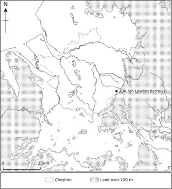
All the barrows were built on sand and were sited on level ground at just under 100 m above Ordnance Datum next to the eastern side of a marked linear depression, known as the Hooze Hollow, a short distance from the eastern margin of the Cheshire and Staffordshire Plain (a largely undulating lowland region that also extends into Shropshire and Clwyd) (Figs 1 & 2). The stream within this depression is a tributary of the River Weaver. This part of the Plain is characterised by the predominance of Glacial Till, and Glaciofluvial deposits of sand and gravel. To the east of this area, and extending slightly to the south, the land rises to form a plateau and hills dissected by streams and rivers. Here sedimentary bedrocks, such as sandstones and siltstones, together with coal measures, are surrounded by areas of Glacial Till. Of these hills, Mow Cop, rising to 335 m aOD, can be seen to the east of the site of the barrow cemetery. To the north of this hilly landscape, the high ground continues and forms the western fringe of the Peak District, where Millstone Grit is the principal rock type.
The physical geography of the region. The Cheshire, Staffordshire, Shropshire, & Clwyd Plain bounded by the Wirral peninsula & the Mersey valley to the north, the hills of north Wales to the west, the Peak District & associated hills to the east, & the Shropshire uplands & the mid-Severn sandstone plateau to the south. Illustration produced by Rob Edwards (Ordnance Survey data Crown Copyright and database right 2014. Ordnance Survey 100049045)

Lithic artefacts found during the archaeological investigation indicate that the land occupied by the barrow cemetery had seen limited use in the Late Mesolithic period (see below). The site was probably favoured because of its well-drained sandy soil and its proximity to the resources offered by the wetland environment of Hooze Hollow. Pottery recovered from the old ground surface beneath Monument A (see below) shows that this site had also probably played host to some Early Neolithic activity.
MONUMENT A
Interpreting the structural sequence
The form of the monument and the nature of its stratigraphy have presented some difficulties concerning interpretation. In essence, the problem relates to the chronological placing of the ring of boulders and whether it had any direct relationship with the turf structure that lay beneath the barrow mound.
The turf structure
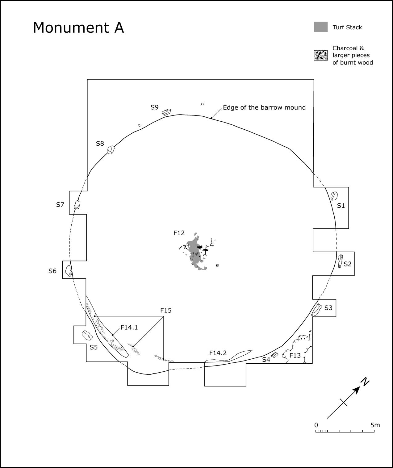
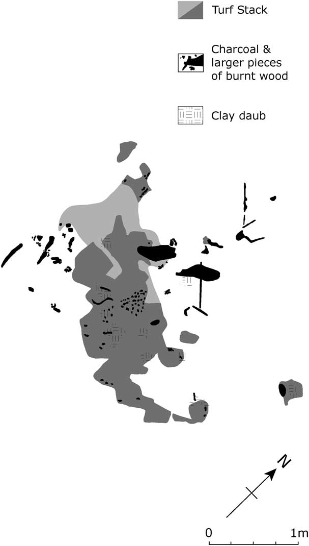
A turf stack (F12) was erected directly onto the sandy subsoil near to the centre of the overlying mound. Its remains, together with associated pieces of timber and clay daub, were spread over an area 3×3.5 m (Figs 3 & 4). The original shape of the stack could not be discerned with certainty, but was probably rectangular or L-shaped. It was orientated north-west–south-east, and measured c. 1×2.3 m and stood up to 0.4 m in height. The individual turves used in the construction were recognised as dark grey sandy patches with an average size of 0.25×0.3 m. The whole structure had been burnt. Some of the turves had scalloped edges, which may be the result of their stacking or when the structure collapsed. Daub was not found in significant quantities, but seemed to mirror the outline of the turves. Lying over and adjacent to the remains of the stack were several large pieces of burnt timber, plus smaller pieces of wood (twigs and branches) which were also burnt. A sample submitted for radiocarbon dating from one of the larger pieces of timber returned a date of 2275–1691 cal bc (3600±100 bp) (HAR-5533).
Site plan of Monument A. Drawn by Cheryl Quinn

Plan of the turf structure, F12, underlying the barrow mound, Monument A. Drawn by Cheryl Quinn

All the evidence regarding this feature seems to indicate it was some sort of platform that had collapsed and had been burnt prior to the construction of the barrow mound. A small amount of cremated human bone was found amongst the remains of the stack; this included two fragments of cranium and two small fragments of limb bone (Walsh pers. comm.). The discovery of cremated bone, together with fragments of cinerary urns from the associated ground surface (see below), suggests that the structure was linked to funerary practices taking place in the immediate vicinity. However, it is unlikely that it was a cremation pyre (see below). Robina McNeil thought that the structure may have served as a mortuary house, where corpses were left exposed to aid their decomposition and where the disarticulation of the bones took place (McNeil Reference McNeil1982b, 48).
The barrow mound
Prior to the raising of the mound (Fig. 3) the turf had been stripped off. Slight remains of this old ground surface had survived as a patchy layer of grey sand [37]. In most places this deposit was only a few millimetres thick, but in the southern and north-western parts of the excavated area it filled shallow hollows up to 0.2 m deep.
The mound was constructed of sand scraped up/excavated from the surrounding area – no evidence was found of a surrounding ditch. This material [3] consisted essentially of loose orange and hard mottled orange–white sands. The latter material, which was interspersed with bands of iron pan, was generally found below the other. The distinction between the two types of sand is not believed to represent any temporal difference in construction, but is thought to represent different quarrying zones. The mound was about 22 m in diameter and stood up to 1 m above the buried ground surface. The angle of slope around its circumference (about 20° from the horizontal) suggests that the mound was not constructed to any great height. Around the fringe of the mound was a black/grey–brown sandy silt [4], which is likely to have been the remains of a turf capping.
Stratigraphically, it is unclear whether the mound was raised within the area defined by a pre-existing circle of stones, or that these monoliths were positioned later around the mound in order to define it. Whatever the sequence, the boulders were discovered standing proud around the circumference of the earthwork and hence are not regarded as an ‘intermittent kerb’.
Underlying the southern edge of the mound was a discontinuous curving band of charcoal (F15), representing the probable remains of wattle hurdling. It was directly associated with (partly situated within) a very shallow, curving, and discontinuous depression (F14), which was filled with a dark grey sand. (The two lengths of F14 are labelled as F14.1 and F14.2 on Fig. 3). A series of shallow depressions (F13), also containing a dark grey sand, were recorded immediately adjacent to (east of) two of the boulders forming the stone ring – S3 and S4. The relationship of these features with the circle of boulders and the barrow mound is ambiguous. F13 and F14 were thought on excavation to be the remains of a turf construction, which together with F15 perhaps formed some kind of free-standing boundary or barrier. Although F14 and F15 had a direct stratigraphic relationship with the overlying mound they were considered by McNeil to be unrelated to the construction of the barrow. It is conceivable, however, that both these features were part of the structure of the barrow and originally defined its southern extent. In comparison with other monuments, the band of charcoal bears some resemblance to the stake rings beneath, or used as revetments in, barrows in mid- and north Wales, for example at Trelystan and Brenig (Britnell Reference Britnell1982; Lynch Reference Lynch1993a). F13 lay beyond the remains of the mound and may have been dug to provide earth for its construction. It should be noted that F13 and F14 were hard to distinguish from the patchy remains of the old ground surface [37]. Charcoal from F14 produced a date of 3093–2200 cal bc (4100±160 bp) (HAR-5534).
The ring of boulders
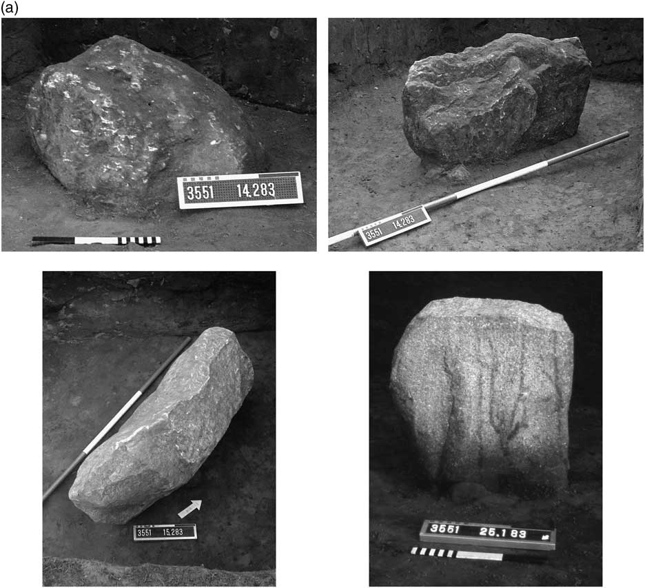
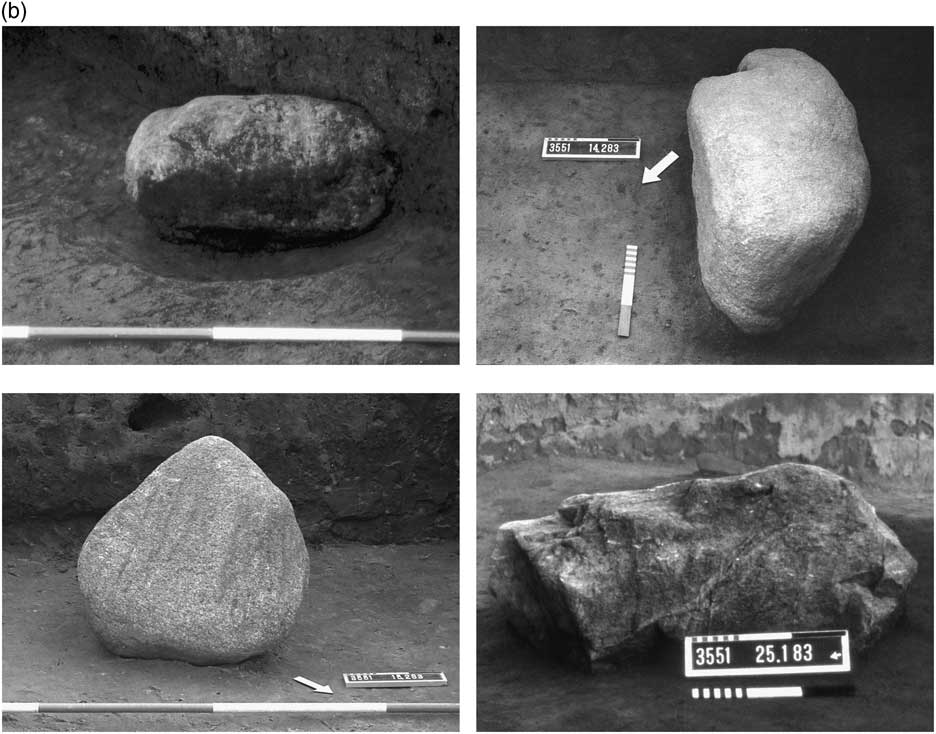
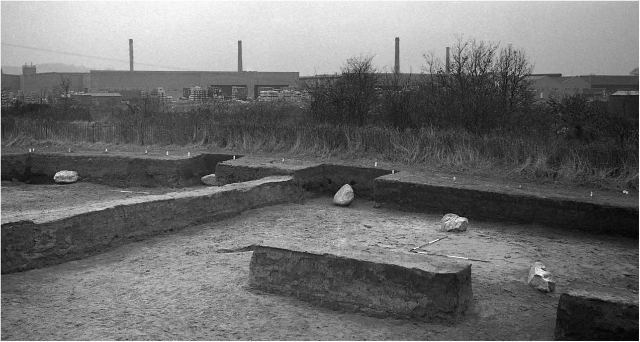
The stone ring was sub-circular in shape and consisted of two unequal north–south arcs of boulders, which, according to slightly differing radii, were set out from different positions just less than 2 m apart (Fig. 3). The eastern arc consisted of four stones (S1–4) (Fig. 5a) and the western arc of five stones (S5–9) (Figs 5b & 6). From the inner faces of S4 and S9, and S1 and S5 the ring measured approximately 22.2×23.5 m. The stones forming both arcs were between 4.6 and 5.8 m apart, based on their centre points. All had been placed onto the subsoil without the use of pits, with the possible exception of S4 where a shallow depression around the stone was noted. A slight depression was also seen in the subsoil along the inner face of S5, but this is thought to have been caused by the weight of the boulder. It is unclear whether a shallow sub-rectangular depression (F10), measuring 0.5×0.7 m, next to S9 was related to the placement of the stone.
(Continued)

The individual boulders forming the stone ring (except S9 – no individual photograph exists of that stone, but see Fig. 6). Photographs produced by David Heke. A 0.3 m scale is used in the photographs of S1, S4, S6, and S8, and a 2 m ranging pole (0.5 m divisions) is used in the photographs of S2, S3, S5, and S7. a: top row, left: S1; top row, right: S2; bottom row left: S3; bottom row right: S4 b: top row, left: S5; top row, right: S6; bottom row left: S7; bottom row right: S8

The western arc of boulders forming the stone ring (S5–S9) looking south, with 2 m ranging poles used as scales. Photograph produced by David Heke

S4 and S7 had been set vertically. The other stones were laid flat. It is apparent from their careful positioning that they had not fallen over. Rocks found next to S2 and S4 appear to have acted as packing stones to maintain the position of the boulders. The heights of the stones varied from 0.34 m (S1) to 0.71 m (S7). All the stones were glacial erratics: S1 and S2 were sandstone; S3, S6, S8 and S9, dolerite; and S4, S5 and S7, granite. With the exception of S7, which was triangular in shape, all were lozenge-shaped blocks. The long sides of every stone formed the circumference of the ring. S1, S5 and S6 had a rounded appearance, the other boulders were more angular. The top face of S4 and northern face of S9 had possibly been cut. Further details of the individual boulders are presented in Appendix 1.
While such boulders are not uncommon within the local Glacial Till, it would seem that they were carefully selected for their size and appearance. Aesthetic considerations may also have played a part in the positioning of the stones in relation to one another. However, it should be stressed that no patterns have been discerned in respect of the size, shape, and geological origin of the boulders, or in the manner they were placed on the ground (vertically and horizontally). In addition to these large stones, two smaller glacial-erratic boulders were discovered: one located between S8 and S9; the other to the north of S9. As they lie on the line of the western arc, both may have formed an integral part of the circuit.
The northern and southern gaps separating S1 and S9, and S4 and S5 measured 15.75 m and 15.8 m, respectively, based on the centre points of these stones. If the spacing noted between the stones forming both arcs was maintained, each gap would have provided enough space for two additional stones. However, there was no evidence of any hollows where the stones may have rested, or any evidence of disturbance, such as deeper ploughing in this area, that may have accounted for the removal of the stones (the tops of the boulders were all found below the base of the ploughsoil). On this basis it is considered that the breaks in the circuit of stones were original. If the stone ring was a free-standing construction which pre-dated the barrow mound, it is likely these two gaps represented opposing entrances/exits, perhaps reflecting a significant alignment and providing access to the turf structure at the centre of the monument. The assertion concerning a putative thoroughfare is supported by the extension of this alignment (orientated NNW–SSE) to Monument B.
The disparity between the two arcs of stones suggests that both were not laid out in a single operation. Although the ring is relatively modest in scale, it would have still required a fair degree of organisation, effort, and resources to construct – made more difficult by the local wooded environment (see below). Therefore, the establishment of this structure is likely to have been particularly important in advancing and helping to maintain (a symbol of) social unity. However, the east–west split and the differential nature of the arcs perhaps indicates that two communities were involved (conceivably emanating from the low-lying ground to the west and the higher land to the east). If so, the constructional differences may have helped to preserve separate notions about group identity, relating to a perception of ancestry and a sense of place. It is equally possible that the two arcs were positioned in relation to the rising and setting of the sun. If this was the case, the monument might have functioned as a symbolic metaphor for the passage of time and the cycles of life.
Pottery from the monument
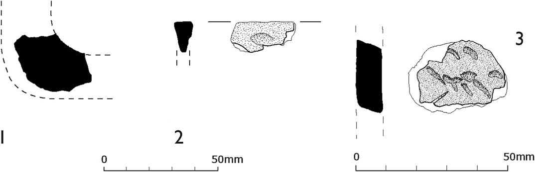
Seventeen sherds of prehistoric date, weighing 53 g, were recovered from the monument. The earliest material represented is four very abraded sherds in a dark grey, hard, and sandy fabric (total weight 8 g). These include one fragment from an out-turned rim, and all, on the basis of the fabric, are probably of earlier Neolithic date. They appear to be residual items occurring within the old ground surface beneath the mound, [37]. They were located in the north-west and central sectors of the later monument. Most of the sherds came from a small area in the north-western sector of the old ground surface and are Early Bronze Age in date. A total of 12 sherds, weighing 44 g, derive from a minimum of five vessels, all of which were probably urns on the basis of the wall thicknesses represented. All are highly abraded, and often one or both faces of the sherd are missing. The five fabric types present mainly contain sparse or medium distributions of grog inclusions of varying size, while two sherds contain large rock inclusions only. Diagnostic sherds include: one base angle from a large urn, with a red outer surface, grey core, and interior surface, and medium dense large grog inclusions (Fig. 7.1); a flat externally expanded rim sherd from a small vessel of Bronze Age date, decorated with an oval finger-tip impression (probably one of a row) below the rim. It has a grey outer surface, buff core, and interior surface, and sparse small grog inclusions (Fig. 7.2); and two wall sherds with cordons, probably from a Cordoned Urn (not illustrated, identified from sketches of sherds which are now lost). From the mound material, [3] and [4], above [37] there are two further wall sherds of Early Bronze Age date, one of which appears to be from the shoulder of an urn.
1–2: Early Bronze Age pottery from Monument A; 3: sherd from a Beaker vessel from Monument B. Drawn by Cheryl Quinn

(Pottery description: Ann Woodward).
MONUMENT B
Interpreting the stratigraphy
Two main phases are recognised in the barrow’s construction. Unfortunately, leaching and the levelling actions of the plough have made it difficult to establish the levels from which some features were cut. Many of the cremation pits are recorded as cutting, and being overlain by, the Phase 1 barrow mound. While some burials were clearly inserted into the earlier earthwork, it is conceivable that others were placed on top of the mound, and surrounded and covered over by small deposits of sand and turf, resulting in the gradual enlargement of the monument (and giving the appearance of cut features when investigated). Despite the dating of the cremated bone by Walsh (Reference Walsh2013), the relative chronological position of the majority of the cremation deposits and the other funerary features remains unclear. However, as there is no evidence of intercutting it is reasonable to suppose that the majority of the interments were marked in some way by enduring (perhaps stone) markers.
The construction of the barrow
Phase 1: Overlying the natural subsoil, beneath the earlier barrow and the later enlarged mound, were occasional patches of dark grey sand containing gravel [36], interpreted as the vestigial remains of turf that formed the ground surface on which the monument was built. Sitting on this surface, beneath the earlier mound, the remains of three burnt branches were found. The surrounding burnt sand indicates in situ burning, possibly representing the clearance of vegetation from the site.
Two sherds from the same Beaker vessel were recovered from about 5 m apart within the south-eastern sector of the later monument. One sherd, from [36] does not survive, but is recorded as a sketch in the excavation archive. The other fragment was found in the material used to construct the barrow mound [4]. It weighs 6 g and is a wall sherd from a large Beaker vessel, decorated with rough horizontal rows of close-set diagonal incised strokes (Fig. 7. 3). It has a light red outer surface, grey core, and red interior surface, with sparse occurrence of small sand, medium grog, and large rock inclusions.
(Pottery description: Ann Woodward).
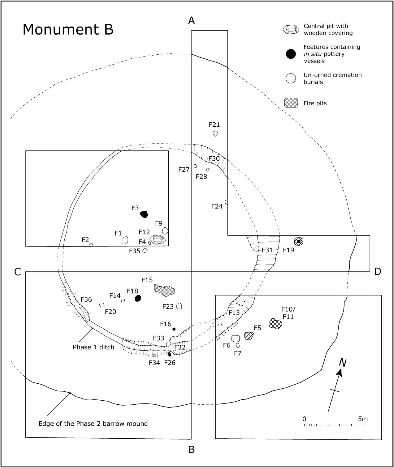
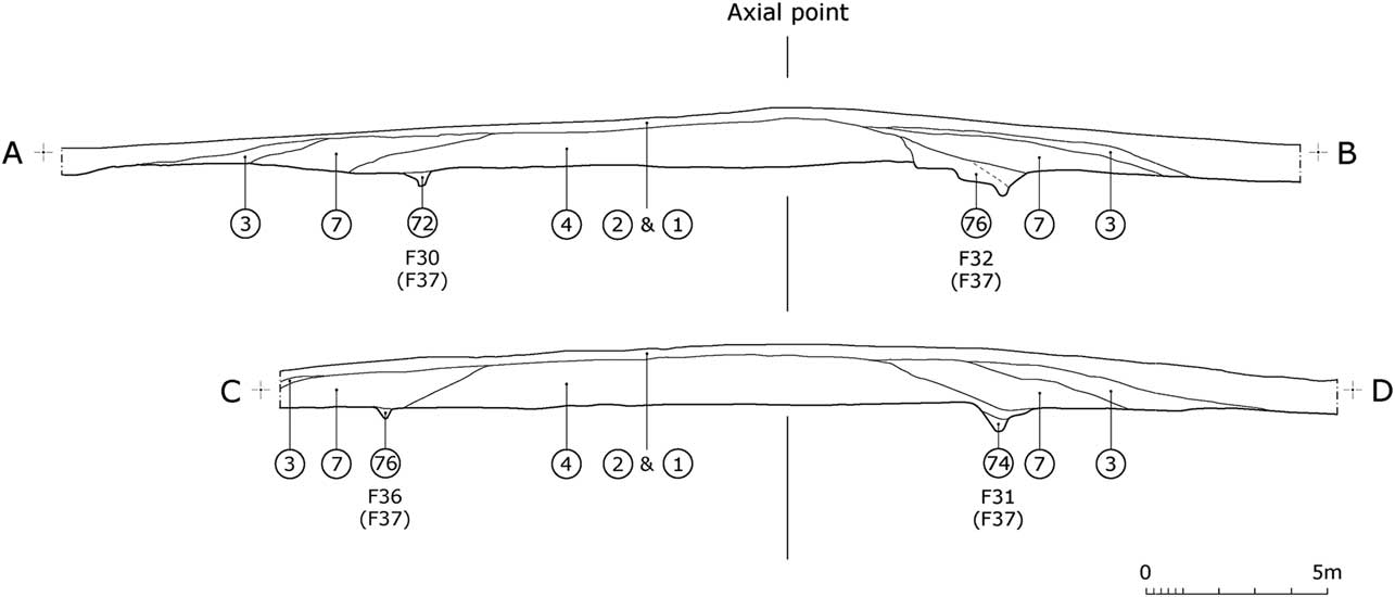
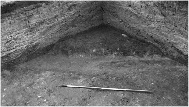
The earlier barrow mound was defined by a ditch, F37, with individual feature numbers allocated to the five sections excavated – F13, F30, F31, F32, and F36. In plan the ditch was roughly circular, measuring 15.5×18 m internally, with the inner lip marking the extent of the construction of the barrow mound (Figs 8–10). The ditch was found to be extremely irregular in size and shape, considered to be largely the result of the unstable nature of the sand on which the barrow was built. Its width across the top varied from 0.7 m to 2 m and it was 0.25–0.8 m deep. In profile the ditch was either V-shaped (F30, F31, and part of F36) or had a level base (F13 and part of F32), but was frequently found to have been dug as a series of scoops. While the ditch acted as a quarry for the construction of the barrow mound, its principal function, in relation to its fairly limited size, was to demarcate the mound. The bulk of the material for this earthwork must have been scraped up from the surrounding subsoil. The barrow mound [4] was mainly composed of a podsolised sand, varying in colour from pink to orange and yellow to brown, with the occasional remains of turves (recognisable as purple–brown marks). The mound stood to a maximum height of 1.5 m above the level of the subsoil. The angle of slope around its circumference (about 35° from the horizontal) may imply that the mound was constructed to a greater height than Monument A and that it has suffered more from the reducing effects of later ploughing. The mound was constructed without the apparent aid of stakes or posts. The fills of the encircling ditch, [38], [72], [74], and [76], consisted of loose, mixed pink and grey sands, and included fragments of charcoal in F13 and F32. Charcoal from F13 produced a radiocarbon date of 2136–1692 cal bc (3560±80 bp) (HAR-5538). The fills of the ditch were derived directly from the mound. (The fills of the ditch sections in the south-western part of the monument, F32 and F36, are both recorded as [76].) Subsequent slumping of the earthwork resulted in the ditch fills being largely sealed by the material from the mound, with this layer, [4], extending up to several metres past the outer edge of the ditch.
Site plan of Monument B. Drawn by Cheryl Quinn

Sections across Monument B. Drawn by Cheryl Quinn

South-eastern quadrant of Monument B, looking north-west. Scale: 2 m ranging pole. Photograph produced by David Heke

Phase 2: The barrow mound was enlarged to about twice its original size. Its exact dimensions are not known because the western portion lies within the garden of the neighbouring property and because of degradation from ploughing. The full extent of the mound is likely to be in the order of 30×32 m (Figs 8 & 9). The Phase 2 construction consisted of sand scraped up from the surrounding area (no evidence of a ditch was found) and dumped on the back of the Phase 1 mound, which was then covered with turf. The enlarged barrow rose more gently than the earlier monument, but its height could not be estimated because of the levelling effects of the plough.
The sand, [7], was mottled white/yellow/brown, compact, and heavily podsolised, and interspersed with numerous bands of iron pan. Remnants of turves were found regularly dispersed throughout this deposit. They survived as grey, charcoal enriched sand patches averaging 0.2–0.25 m, but with some up to 0.5 m in length. In plan the turves formed a series of concentric, albeit discontinuous, circles. The discontinuity of these turf bands indicated that they did not serve as substantial revetments, but were placed fairly casually in order to help stabilise the sand as it was deposited. The turf capping, [3], was recognisable as a brown–purple–black sand, often slightly silty in texture. It existed as a band 3–9 m wide, up to 0.6 m thick at the base of the mound and reducing in thickness to only a few millimetres at its highest surviving points.
The central pit
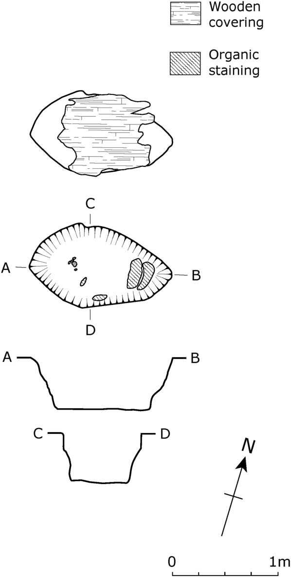
At the centre of the Phase 1 mound lay an elliptical-shaped pit, F12, which was cut from a point one-third of the way up the extant mound (through [4]) and extended into the subsoil. It was orientated east–west and had a flat base with very steep/vertical sides. It measured 0.8×1.37 m and was 0.5 m deep (Fig. 11). On the base of this feature, principally at its eastern end, was some organic staining, possibly of wood. The pit was filled with two deposits – predominately a grey sand, plus some orange sand, with intermittent flecks of charcoal. Both deposits were recorded under the same number [34]. The fill of the pit was covered by a large piece of burnt wood [33] (Fig. 11). It is evident that the wood had been burnt prior to its placement within the barrow as there were no signs of associated burning within or around the pit. A sample from this wooden lid was submitted for radiocarbon dating and returned a date of 2027–1621 cal bc (3490±80 bp) (HAR-5537). The well-preserved form of the pit, notably its un-eroded sides, plus the nature of its infilling and covering, all point to the likelihood that it had not remained open for very long. Although no remains of a corpse were identified, the size and position of this feature within the barrow suggests that it may well have served as a pit for a crouched inhumation. If it did fulfil this function, the skeletal remains will not have survived the prevailing acidic conditions evident from the pH tests carried out during the investigation of the site. In addition to cutting through [4], the pit was sealed by the same layer.
F12, the central pit in Monument B. Drawn by Cheryl Quinn

The size, form, and position of the pit strongly suggest that this feature served as the focal point of the monument. While the nature of the stratigraphy does not provide a clear indication about the chronological placing of this feature, it may be suggested that it was the primary grave, covered by the lowest level of the mound, and then recut to add more remains or to take relics away. This scenario is based on analogy with the wider pattern (Bradley Reference Bradley2007, 162; Garwood Reference Garwood2007b, 145–8).
The burial of urns and related vessels
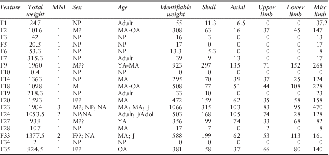
In the description of the interments presented below, the urned and un-urned burials have been dealt with separately and are in feature number order. The descriptions of the features include brief details of the cremated remains, while a more detailed osteological account and a table summarising the data are presented in Appendix 2. The pottery descriptions are by Ann Woodward.
Three complete/substantially complete pottery vessels were discovered in pits in the southern sector of the Phase 1 barrow, F16, F18, and F26, plus the fragmentary remains of an urn in F3 in the northern part of that mound (Fig. 8). Only F3 and F18 can truly be regarded as urned burials. In addition, sherds of a Collared Urn were discovered in one of the fire pits, F19 (see fire pits, below).
F3. Poorly defined oval feature, c. 0.6 m across, 0.09 m deep. Cut into the upper part of extant Phase 1 mound, [4], & heavily disturbed. Contained a small amount of cremated bone (assessment of sex & age not possible) & remains of large Collared Urn. A scatter of sherds from this vessel found nearby, together with fragments of cremated bone.
A total of 23 sherds from the rim, collar, & body of the urn recovered from this feature & surrounding area. All but 2 scattered sherds found immediately above F3 or within 1 m of its centre. Single rim sherd & 7 wall fragments from filling of F3, scatter of sherds included fragment from base of the collar, five decorated wall sherds from collar, & nine plain wall sherds. Sherds from F3 itself weigh 120 g, those from the scatter total 212 g. Rim & collar profile reconstructed in Figure 12.1. Vessel has tapered rim with deep concave internal bevel & straight-walled collar. Surfaces are red–buff; fabric contains medium density of large grog & sparse large rock inclusions. Collar decorated with horizontal rows of open chevrons forming herringbone design. Each element of the design formed by impressing a short length of twisted cord. On internal bevel of rim are two horizontal rows of twisted cord impressions. Also from vicinity of F3, but recorded as coming from the mound material, [4], were three further plain wall sherds, weighing 9 g. These also appear to derive from an urn, but one with thinner walls & thus smaller in size.
Collared and Cordoned Urns from Monument B. 1: F3; 2: F16; 3: F18; 4: F26. Drawn to the same scale by Bevis Sale & Cheryl Quinn

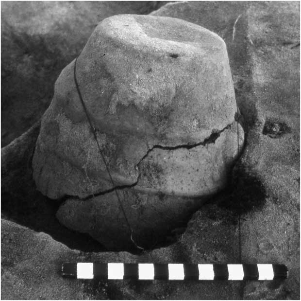
F16. Oval steep-sided pit, 0.5×0.65 m, 0.4 m deep, with two stakes positioned next to southern side. Pit contained inverted Cordoned Urn (Fig. 13). Large lumps of charcoal found inside urn & in underlying ashy fill of pit. Charcoal dated 2132–1537 cal bc (3500±100 bp) (HAR-5539). No bone discovered in vessel or fill of feature. Pit lay close to edge of Phase 1 mound – cutting & overlain by [4].
F16 inverted Cordoned Urn in situ. Scale: 15 cm. Photograph produced by David Heke

The Cordoned Urn is almost complete, ht: 165 mm (Fig. 12.2). Bright orange–red surface; fabric contains medium dense grits of medium size & variable amounts of grog. Body carries two plain horizontal cordons, dividing vessel into three zones; rim has wide internal bevel decorated by two parallel lines of twisted cord impressions joined by short inclined lines, also executed in cord. Uppermost zone of body bears series of twisted cord vertical lines defined by similar but horizontal lines just below rim & just above higher shoulder ridge. The similarity between the decoration of this Cordoned Urn & the Collared Urn from F26 should be noted. This, together with the proximity of their find spots, indicates that the vessels, although apparently stylistically distinct, may have been made by closely related potters. Radiocarbon dates from this feature & F26 suggest deposition at about the same time.
F18. Oval, steep-sided pit, c. 0.4×0.45 m, 0.45 m deep, into which a Collared Urn was placed – found crushed & lying horizontally, base to south, covered with sand mixed with large pieces of charcoal. Urn contained cremated remains of a man of mature to old age (c. 30–50+ years) & fragments of a child’s skull (probably residual), plus charcoal. Included with the cremated remains were six small pieces of shell (length: 3–7 mm) of a gastropod & a bivalve, both probably marine species (Kate Riddington pers. comm.), & a speck of copper. The pit lay within the Phase 1 mound, cutting & overlain by [4].
The Collared Urn (Fig. 12.3) is almost complete, ht: 270 mm. Brown–orange surface; fabric contains sparsely distributed medium & large rock inclusions. Slightly convex profiled collar surmounted by simple rounded rim. Shoulder rounded, but quite distinct, base relatively narrow. Collar bears eight horizontal lines of twisted cord decoration & on neck are further lines, more irregular than on collar & executed in discontinuous fashion, giving impression of rough panels of decoration. A further rim sherd from this vessel recorded separately & two further sherds from same urn, including a fragment from the base of the collar, found in the mound material, [4], slightly further to the west, in the vicinity of F20. These weigh 7 g.
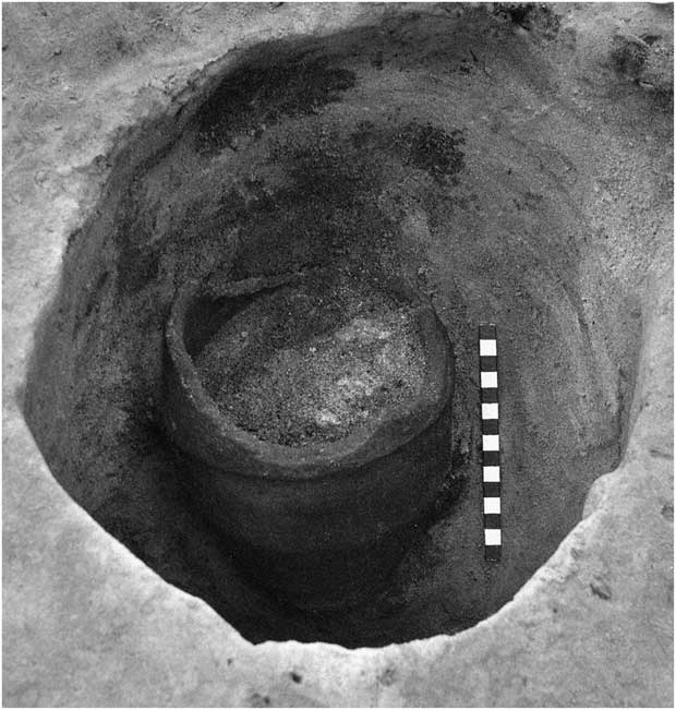
F26. Oval, vertical-sided pit, 0.33×0.4 m, 0.45 m deep, containing small Collared Urn, set upright on base of feature (Fig. 14). Urn did not contain any bone, but was filled with ash & charcoal, & included some small pieces of burnt sandstone near top. Ash & charcoal deposited round vessel & pit capped with charcoal producing date of 2032–1625 cal bc (3500±80 bp) (HAR-5541). Pit cut later accumulation of [4] (slumped fabric of Phase 1 barrow mound), which partly filled F32 (segment of F37 – ditch which originally defined Phase 1 mound) & was also sealed by [4].
F26 Collared Urn in situ. Scale: 15 cm. Photograph produced by David Heke

The Collared Urn (Fig. 12.4) is 215 mm tall. Most of rim & collar missing, having broken away in antiquity. Buff–grey fabric contains moderate density of medium-sized & large rock inclusions. Vessel possesses weak, slightly concave collar below simple rounded rim & very weak shoulder. Collar decorated with three rows of finger-nail impressions, neck with series of very sharply inclined diagonal lines of twisted cord impressions.
The un-urned burials
F9 and F20 may be regarded as the most prestigious of the un-urned burials and were located within the Phase 1 mound (cutting and also being sealed by [4]). F9 was situated near the centre of the mound, whereas F20 lay close to its edge (Fig. 8).
F9. Circular, near vertical cut, 0.56 m diam., sloping base, depth 0.14–0.23 m. In centre of feature was tightly defined, oval concentration of cremated bone, surrounded by sand containing charcoal. Neat arrangement suggests bones were contained within some sort of organic container/bag. Cremated remains are of a young–mature adult, possibly male (c. 20–35 years) & have been dated to 2115–1896 cal bc (3620±28 bp) (OxA-26843). Amongst the cremated bones was a burnt plano-convex knife (Fig. 15.1) in three pieces which were found separately & appeared to have been casually included.
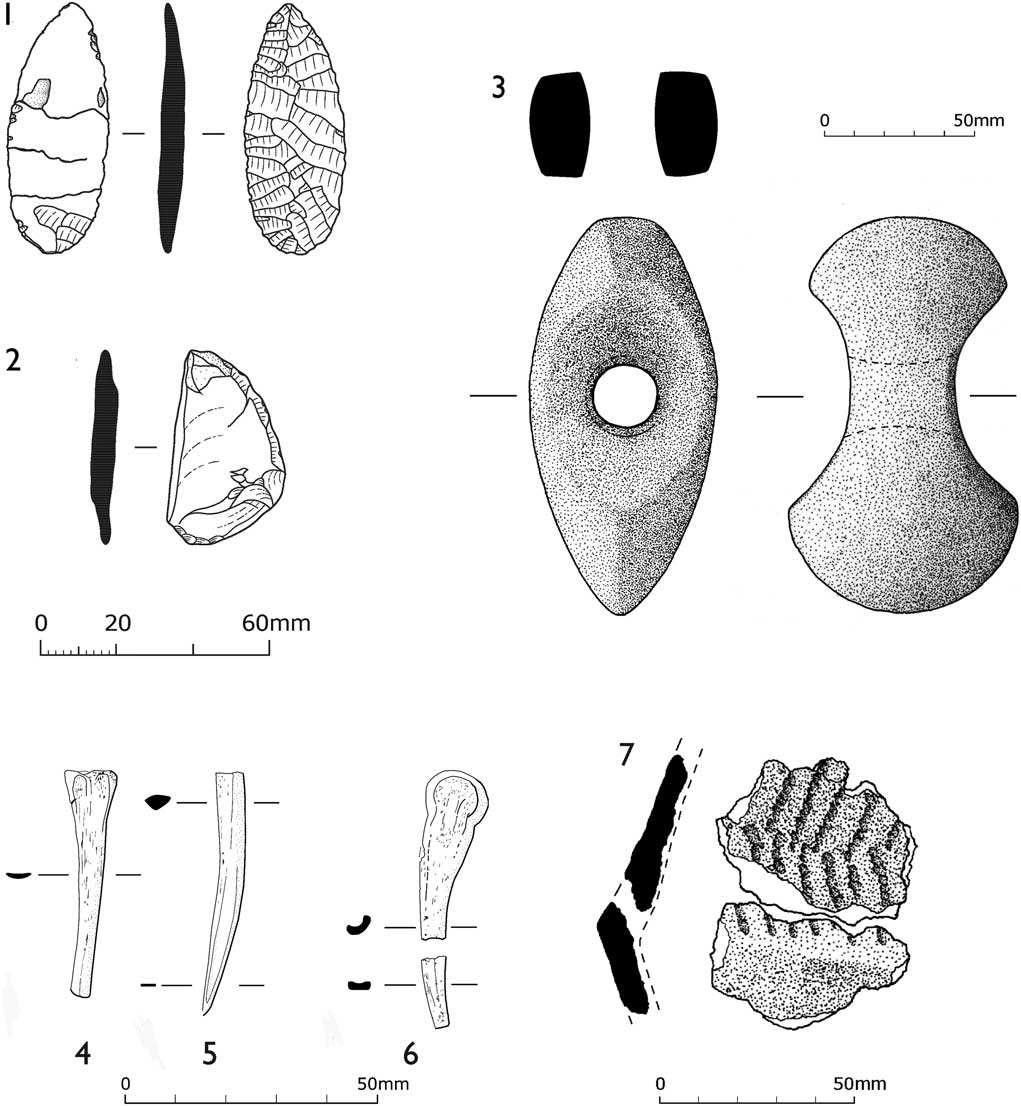
Grave goods and pottery: 1: plano-convex knife from F9; 2: side scraper from F33; 3: battle-axe from F20; 4–5 bone points from F20; 6: bone point from F14; 7: sherd of part of a Collared Urn from F19. Drawn by: 1–2 Tanya Williams; 3 & 7: Bevis Sale & Cheryl Quinn; 4–6: Cheryl Quinn

The knife has been reassembled & measures 58.3×23.1×5.4 mm. It has been subjected to heat & as a consequence it is impossible to determine original raw material type. It is uncertain whether breakage took place prior to, or after, heating. Dorsal surface covered by long, low angled, sub-paralleled removals defining lanceolate shape. A few, low angled removals on ventral surface have produced a flat surface, particularly to remove the bulb of percussion. It is considered that the tool was heated to no more than 300°C (well below the temperature used in cremation: Appendix 2). In addition, the level of crazing (an indication of thermal shock) is limited, implying that heating & cooling took place slowly; it appears that the tool was added to the cremation while still warm, & remains allowed to cool before being placed in the container.
(Object description & discussion: Ian Brooks).
F20. Near vertical, oval-shaped pit, 0.35×0.43×0.7 m deep. At centre of feature & relatively near the bottom was a tightly defined circular concentration of cremated bone surrounded by sand containing charcoal. As with F9, the neatness of this arrangement suggests the bones were contained. Cremated remains are of a mature adult, possibly female (c. 30+ years) and were dated to 1893–1740 cal bc (3490±29 bc) (OxA-26841). Much ash & charcoal had been thrown into the pit, covering the burial.
Placed horizontally next to the cremation & against the side of the pit, was a battle-axe (Fig. 15.3), in relatively good condition despite signs that it had been heated, possibly as part of the cremation process. This & subsequent weathering have left it covered in a soft, reddish material, probably iron oxides, so that no trace of the original surface can be seen. Despite this, the shape of the object has remained apparently unaltered. It is 133 mm long; maximum breadth: 61.5 mm, depth: 34 mm at the shaft-hole, increasing to 76 mm at the widely expanded ‘blade’ end, & to 65 mm at the butt. Butt is flattened off from top to bottom, tapering in both directions. Shaft-hole has hour-glass shaped profile, but not pronounced; min. diam. in the central part of hole: 21 mm, with traces of rings left by boring process. The weight is 600 g. There are no clear signs of use, although there may be minimal traces of battering at the butt end; blade seems to be slightly chipped. The battle-axe was thin-sectioned (No. CH70 in the Council for British Archaeology Implement Petrology series). The stone has been identified as picrite (Group XII in the implement petrology series) from Cwm Mawr near Hyssington on the Shropshire/Powys border.
(Object description: Fiona Roe).
Analysis of the cremated bone by Walsh (Reference Walsh2013), found that included with the remains were two fragments of animal bone distorted by fire (Figs 15.4–5), one of which had certainly been made into a pointed artefact. Ian Smith identified one as an unfused distal fibula, including the metaphysis, of pig (Sus sp.). It is 44.2 mm long and shows no obvious pre-cremation modification, although its form (being long, relatively straight & narrow) is almost a ready-made blank for a pointed object. The animal species & bone type of the other fragment (length: 47.6 mm) could not be identified. It had been fashioned into the lower part of a shaft of a pin or similar object, tapering to a sharp point. Also included with the cremation deposit were three pieces of struck flint, which had been heated. None showed signs of secondary working & one piece, a blade, is possibly Late Mesolithic in date. As they are not tools it would seem that their inclusion in the burial was accidental (Ian Brooks pers. comm.).
The other un-urned cremation burials examined during the excavation can usefully be divided into those that were directly associated with the material of the Phase 1 mound, [4], although not necessarily dating to that phase, (F1, F2, F4, F14, F21, F23, F24, F27, F28, F33–F35) and those (F6 & F7) that are sealed by the Phase 2 construction (Fig. 8). As indicated below, in the majority of the graves one person was interred. Apart from two features which contained possible residual remains of juveniles (F2 & F35), two graves contained the remains of two individuals (F24 & F33) and, in F23, the remains of three people were discovered. Like F9 and F20 and the urned interment F18, objects were incorporated in some of the burial deposits (F1, F14, & F33).
F1. Oval pit, c. 0.45×0.6×0.25–0.52 m. Sandy fill contained a little charcoal, with most of the cremated bone deposited next to the side of the cut. Cremated remains are of an adult of indeterminate age found with a small fragment (length: 25 mm) of the shaft of a bone pin/point, fashioned from an unidentified solid bone (Ian Smith pers. comm.), circular in cross-section (diam. 3.5–4 mm; not illus.). Pit cut into [4] & overlain by ploughsoil [2]/topsoil [1].
F2. Shallow oval pit, 0.25×0.3 m, containing cremated bone & some ash. Cremated remains are of a probable man of mature to old age (30–50+ years), with possibly a residual fragment of juvenile tooth. Pit cut into [4] & overlain by ploughsoil [2]/topsoil [1].
F4. Shallow irregular-shaped pit, c. 0.2×0.3×0.3 m. Filled with sand & charcoal flecks. Although no bone was found, the feature is interpreted as the base of a cremation pit, cut into [4] & probably overlain by ploughsoil [2]/topsoil [1].
F6. Very shallow oval depression, 0.55×0.8 m, only a few centimetres deep (exact depth not recorded). Sandy fill contained cremated bone & some ash & charcoal. Sex & age of person not determined. Pit cut into outer limits of [4] of slumped Phase 1 mound & overlain by [7], the sand of the Phase 2 barrow.
F7. Oval, bowl-shaped cut, 0.4×0.45×0.17 m. Sandy fill contained cremated bone, some ash & charcoal. Cremated remains are those of an adult, of indeterminate age & sex. Pit cut into the outer limits of [4] & overlain by [7] & lay immediately south of F6.
F14. Oval, shallow pit, c. 0.35×0.4×0.3 m, filled with sand, charcoal, & cremated bone of a mature individual, age c. 30+ years of indeterminate sex, dated to 1883–1691 cal bc (3462±33 bp) (OxA-26840). Included with remains were two pieces of animal bone, which appear to be from the same item (Fig. 15.6). Ian Smith states that the larger piece (33.9 mm long) is a partial (one half of) fused distal metapodial from an ungulate (sheep/goat/roe deer) probably a metacarpal & most probably sheep (Ovis aries). The condyle is unworked, but the smooth nature of the distal shaft fractures suggest it may have been modified, plausibly into a pin, as originally noted by Walsh (Reference Walsh2013). The smaller piece is 14.2 mm long. The fragments seem to be associated but do not conjoin, therefore some bone is missing in the area of the probable recent transverse fracture. Charcoal includes oak, ash, & possibly beech & hornbeam. Pit cut into [4] & overlain by ploughsoil [2]/topsoil [1].
F21. Shallow, sub-circular depression c. 0.3 m across. Contained ash, charcoal, burnt soil & sandstone. Although no bone was found, the feature is interpreted as the base of a cremation pit, cut into the outer limits of [4] & overlain by plough soil [2]/topsoil [1].
F23. Oval, steep-sided pit, c. 0.35×0.4×0.45–0.5 m, containing cremated bone & little charcoal. Some bones found to be jointed on excavation. Three individuals present: two adults of mature age (30+ years) (one probably male) & a juvenile (<12 years). Located within the Phase 1 mound, cut & was sealed by [4].
F24. Oval pit, c. 0.4×0.45×0.45 m, near vertical sides, flat base. Cremated bones found mainly at bottom of pit, with large lumps of charcoal next to the south-western edge. Two individuals: an adult of indeterminate sex & an older child/ young adolescent (c. 11–16 years). Sample of bone dated to 1897–1741 cal bc (3495±29 bp) (OxA-26842). Located within the Phase 1 mound, cut & was sealed by [4].
F27. Oval bowl-shaped pit, c. 0.3×0.35×0.15 m, containing cremated bone & some charcoal. Cremated remains are of a young adult, possibly male (c. 16–30 years). Located within the Phase 1 mound, cut & was sealed by [4].
F28. Oval depression, c. 0.2×0.3 m, only a few centimetres deep. Sandy fill contained cremated bone of an adult of mature age (c. 30+ years), but indeterminate sex. Located within the Phase 1 mound, cut & was sealed by [4].
F33. Oval pit, 0.45×0.5×0.3 m, near vertical sides, curving base. Concentration of cremated bone more or less in centre, surrounded by sand mixed with a few charcoal flecks, suggesting the bones may have been placed in an organic container. The cremated remains are of two individuals: an adult of mature age, possibly a woman, & a young child, c. 3–6 years. Pit cut inner edge of barrow ditch, F32 (filled with [76]) & was overlain by later accumulation of [4].
Included with the burial was a side scraper (40.3×30.1×8.2 mm), on a tertiary flake (Fig. 15.2). Has been heated to a high temperature making it impossible to determine original raw material type & resulting in a crazed & pitted appearance. Right hand edge appears to have had a series of long, semi-abrupt, sub-parallel removals, however, these are difficult to determine because of the level of heat damage. The nature of the damage suggests that the object was heated to a greater temperature, or at least suffered a higher degree of thermal shock, than the plano-convex knife found with the cremation in F9.
(Object description & discussion: Ian Brooks).
F34. Very steep/vertical, circular cut, 0.3×0.3 m. Burnt stake found at edge of feature. Sandy fill contained large pieces of charcoal & a very small amount of cremated bone (age & sex not determined). Pit cut outer edge of barrow ditch, F32 (filled with [76]) & was overlain by later accumulation of [4].
F35. Roughly circular pit, c. 0.3×0.25 m, containing a little charcoal & cremated remains of an individual, possibly female, of older age (c. 40+ years) & a small fragment of a possible infant limb bone (probably residual). Pit cut [4], but unclear whether it was sealed by that layer or ploughsoil [2]/topsoil [1].
The fire pits
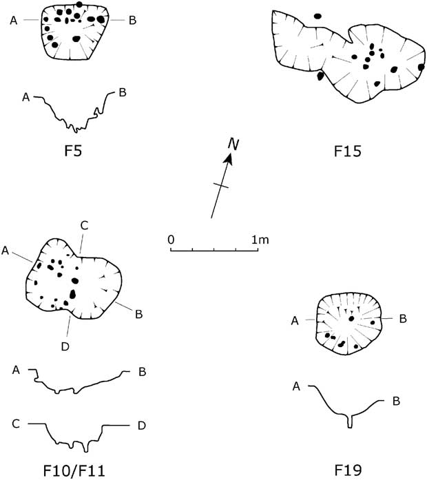
In the southern and eastern sectors of the monument were shallow scoops and pits – F5, F10/F11, F15, & F19 (Figs 8 & 16) – with numerous stakes driven into their bases and sides, and infilled with charcoal and ash. The diameter of the stake-holes was 20–60 mm and their depth 40–60 mm. These features, termed ‘fire pits’ by Robina McNeil, were used for the cremation of corpses (possibly de-fleshed and disarticulated), which were buried elsewhere (McNeil Reference McNeil1982a, 47). Their form strongly suggests that they functioned as under pyre draught pits, where the angled and vertical stakes provided a suitable mechanism for the passage of air to facilitate combustion, as well as helping support the pyre itself (McKinley Reference McKinley1997, 132, 134; noted as part of the pyre sub-structure by Marshall (Reference Marshall2011, 12)).
Fire pits: F5, F10/F11, F15, & F19. Drawn by Cheryl Quinn

With the exception of F15, all lay near the outer limits of the slumped Phase 1 mound. F15 and F19 cut this earlier earthwork, formed by [4], and were also sealed by it. In relation to its position, F15 is probably the earliest of these features. F10/F11 was also inserted into [4], but appears to have been partially overlain by [7], the sand forming the Phase 2 mound. F5 cut through [7] and was sealed by the turf, [3], that covered the lower portion of the enlarged earthwork.
F5. Sub-rectangular, 0.63×0.76×0.4 m, steep sides. Within feature were 14 stake-holes, their positions indicating that some had been driven in vertically, others at an angle. Sides & base of pit not heavily burnt. At the bottom was a deposit of ash, plus lumps of charcoal, above which, around the sides of the pit, were large pieces of charcoal up to 20 mm across, surrounding a central orange–red area of sand. A small amount of cremated bone of indeterminate sex and age was recovered. Charcoal from the pit produced a date of 1896–1505 cal bc (3400±80 bp) (HAR-5535).
F10/F11. Roughly polygonal, 0.6–0.85×1.1×up to 0.23 m, sides steeply sloping except to the east. Within western half was a ring of 16 stake-holes. The stakes, like those in F5, had been positioned at different angles & defined a layer of ash & charcoal, with denser circular deposit of charcoal above. These deposits surrounded by sand, which also extended into the eastern half of the feature. It is possible that the shallower eastern area was used for stoking. From the area defined by the stakes (F10) an extremely small amount cremated bone was found of indeterminate age/sex. Charcoal from the pit produced a date of 1767–1416 cal bc (3300±80 bp) (HAR-5536).
F15. Two shallow oval scoops, 0.6–0.9×c. 1.8×0.1 m (average), form much less well defined than others. Each contained heavily burnt sand & large pieces of charcoal. The remains of 12 possible stakes, mainly in the eastern half, could be discerned.
F19. Oval, bowl-shaped profile, 0.7×0.75×0.35 m (max.). Six stakes driven into base & southern side. In the centre, at its base, was a deposit of ash & charcoal, surrounded by burnt sand. Cremated bone of an adult of indeterminate sex produced a date of 1887–1742 cal bc (3486±26 bp) (OxA-27096).
Fill contained 22 sherds (67 g), from a single vessel. Four sherds decorated, including two, almost joining fragments from the shoulder of a Collared Urn (Fig. 15.7). There is also one base angle sherd, but its outer surface is eroded away. Dark grey fabric contains sparsely distributed medium-sized & large rock inclusions. Shoulder is sharp & traces of rows of vertical & inclined lines executed in twisted cord survive above shoulder line. Vessel form undetermined.
(Pottery description: Ann Woodward).
Within the Phase 1 mound there were several small spreads of charcoal F8, F17, F22, and F25. Two were associated with burnt sand indicating that fires had been set where the material was found or very close by. In relation to their insubstantial nature, it seems likely that they were merely the residues of the cremation process.
Pottery unattributed to a recorded interment
The only sherds of Bronze Age pottery that do not appear to belong to any of the vessels described above are a group of four fragments, weighing 9 g, from [4] found 2.5 m from F24 and F27 in the northern sector of the Phase 1 mound. These contain a medium density of large grog inclusions and probably derive from an urn.
(Pottery description: Ann Woodward).
LITHIC ARTEFACTS FROM MONUMENTS A & B
(Ian Brooks)
One hundred and seven artefacts of worked stone were found during the course of the excavation: 102 (95.3%) of flint and five (4.7%) produced from a variety of cherts. Sixty-seven (62.6%) of the artefacts were from Monument A and 40 (37.4%) from Monument B. The Glacial Till and gravel from Glaciofluvial deposits of the Cheshire and Staffordshire Plain are likely to have been the main sources of both rock types, with watercourses probably concentrating the dispersed resources. The small quantity of chert suggests that the extensive early Carboniferous sources in the Peak District and the Vale of Clwyd (Hind Reference Hind1998; Berridge Reference Berridge1994, 95) were not utilised.
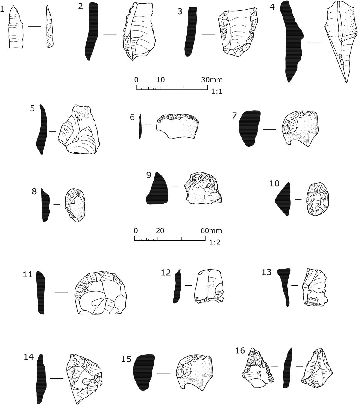
The earliest recorded artefacts date to the Late Mesolithic. These were concentrated within the Monument A mound, while a few were found in the Phase 1 mound of Monument B. The assemblage consisted of an obliquely blunted point (Fig. 17.1), blades and blade fragments, including a backed blade (Fig. 17.2). It is also likely that the proximal end of a backed blade (Fig. 17.3), and a possible awl (Fig. 17.4) were associated with the Late Mesolithic activity. The small scale of the distribution suggests that the site was occupied for a relatively short period by a limited number of people, possibly as a ‘task specific’ location (Binford Reference Binford1983; Butler Reference Butler2005, 114). Such a distribution also corresponds to Mellars’ Type 1 scatter covering less than 10–15 m2 (Mellars Reference Mellars1976, 379).
Lithic tools from Monuments A & B. 1–4, 7, 14 & 15 Scale 1–15, 6, 8–13 & 16 Scale 1:2. Drawn by Tanya Williams

The majority of the artefacts recovered appear to be of a Late Neolithic or Early Bronze Age date. They were mainly found within the deposits forming the barrow mounds. Only two items, a plano-convex knife and a side scraper (Fig. 15. 1–2) were recovered from interments, from F9 and F33 in Monument B, and hence can be said to relate directly to the funerary practices carried out at the site. These two objects, which are described in detail above, are clearly distinct from the rest of the Late Neolithic/Early Bronze Age assemblage, in terms of their size and quality.
Two artefacts were found to have the remnants of polished dorsal surfaces, indicating that Neolithic polished tools, probably axes, were being re-utilised as sources of stone. The grey, opaque flint used for one of these flakes (Fig. 17.5) is typical of the flint from the Yorkshire and Lincolnshire Wolds, possibly suggesting a long-range link for the original tool. The second flake with a polished dorsal surface (Fig. 17.6) has a series of low angle removals along its distal edge suggesting it has been re-used as a knife. Two unmodified blades (not illus.) were also possibly produced in the Neolithic, as they are larger than those which are considered to be of Late Mesolithic date. One has some edge damage suggestive of use.
The dominance of scrapers within the tool group perhaps suggests a domestic character to the Late Neolithic/Early Bronze Age assemblage. Seven scrapers (Figs 17.7–13) were recovered from Monument A: four of these (Figs 17.7–10) were found within the material used to construct the mound, [3]; two came from the old ground surface, [37], below the mound (Figs 17.11 & 17.13); and one from the topsoil, [1] (Fig. 17.12). Four of these items are of the small ‘thumbnail’/‘button’ type (Figs 17.7–8, 17.10–11), with fine, invasive retouch. Such distinctive Early Bronze Age forms often have Beaker associations (Butler Reference Butler2005, 168; Edmonds Reference Edmonds1995, 140–1). It is therefore likely that these particular objects were broadly contemporary with remains of the Beaker vessel recovered from Monument B. Edmonds (Reference Edmonds1995, 141) notes that such items occasionally occur as grave goods and it is conceivable that those from this site were deposited as token offerings to the deceased. The other scrapers (Figs 17.9, 17.12, & 17.13) are somewhat cruder and may have been manufactured either during the Late Mesolithic or the Early Bronze Age.
Three other tools were recovered from Monument A: a broken flint fragment with a covering of ripple flaking over its dorsal surface (Fig. 17.14), possibly the tip of a plano-convex knife, from the topsoil, [1]; a secondary flint flake, which has the whole of its ventral surface removed by low angle, invasive retouch (Fig. 17.15) from [3] – the function of this artefact is unknown; and a tertiary flake of high quality with a relatively broad distal end defined by a series of invasive, low angle removals on the ventral surface, while the tip of the tool had been damaged through use, suggesting it had functioned as an awl (Fig. 17.16). The latter item is of uncertain date, but is probably Early Bronze Age (unstratified).
THE LOCAL BOTANICAL ENVIRONMENT & THE USE OF THE SURROUNDING LAND IN THE BRONZE AGE
(Jim Innes)
Pollen analysis was carried out on samples of deposits from both monuments. The results of this work are summarised below and are set out in an order which relates to the stratigraphic sequence. Following this, a reconstruction of the changing nature of the local environment is presented. It should be noted that the original sample numbers for each barrow, indicated by Roman numerals, are used in this report. Only those samples that contained sufficient pollen for analysis are recorded here.
In the accompanying tables detailing the results of the analysis (Appendix 3), the pollen frequency of each taxon is shown as a percentage of the total land pollen. It is based on counting 200 pollen grains per sample. This figure is considered to represent a statistically reliable total. Fern and moss spores, although counted, were not included in the pollen sum.
Monument A
Sample II came from the turf structure, F12. Tree and shrub pollen dominated the assemblage, providing over 80% of the sum. A variety of herbs was recorded, which, although low in frequency, indicated that some open areas may have existed nearby.
Three samples (III, V, & VI) came from the patchy layer of turf, [37], that formed the old ground surface pre-dating the barrow mound. All three samples were dominated by tree and shrub pollen, principally Alnus (alder), Tilia (lime), Betula (birch), Quercus (oak), and Corylus-type (hazel, but also perhaps including similar pollen from Myrica (bog myrtle)). Low levels of herbs were recorded, with Gramineae (grasses) being the most prevalent.
Monument B
Sample VIII was from the patchy layer of turf, [36], that formed the old ground surface pre-dating the barrow mound. The assemblage was dominated by tree and shrub pollen of the same species recorded in Sample II for Monument A. Again very few herb types were represented, all in low values. (The excavation records do not indicate whether the sample was taken from below the primary or the enlarged mound. However, given the similarities in the results from the old ground surfaces of both barrows (see below), it is likely that the sample was taken from beneath the original mound.)
Sample I came from the sand, [4], used in the construction of the primary barrow. Herbaceous pollen accounted for almost half of the pollen sum, with Gramineae being the most significant. Other plants represented included those often associated with damp, open grassland conditions, eg, Succisa (scabious), Plantago lanceolata (ribwort plantain), Cyeraceae (sedges), Filipendula (meadow-sweet), and Pteridium (bracken). Woody plants were not significant, except for shrub types – Alnus and Corylus-type. Forest trees were present in very low frequencies.
Samples II and III were from F13, the south-eastern portion of ditch F37 which defined the original extent of the Phase 1 barrow mound. Sample III came from the primary silt of the ditch and had a higher proportion of tree pollen than Sample II taken from the overlying fill. The level of Alnus was very high, with Tilia, Quercus, and Betula also strongly represented. Fraxinus (ash) was also noted. Corylus-type and Calluna (heather) were the main shrubs, while herbs of open ground were also present, but in low frequencies. In contrast to Sample III, Sample II had an assemblage in which herb, shrub, and tree pollen accounted for similar proportions of the total pollen count. Gramineae were well represented. Other herbs included Succisa, Plantago lanceolata, Rumex (sorrel), and Taraxacum (dandelion). Corylus-type dominated the shrub pollen, while Pteridium was present in high values.
Sample IV came from the sand, [7], deposited to form the enlarged barrow mound. In this assemblage herbs had more significant values, relative to trees and shrubs. Succisa was again present in high frequencies and a range of other herbs were also noted. Alnus and Corylus-type were present in high quantities, but other trees were poorly represented.
Sample V was from the turf, [3], overlying the sand forming the enlarged barrow mound. Its assemblage was mixed, but was dominated by tree and shrub pollen, which together formed 80% of the pollen sum. Quercus, Betula, Tilia, and Alnus were the major tree species, with Corylus-type also well represented. Some open habitat herbs were still present, eg, Chenopodiaceae (fat hen, etc) and Gramineae frequencies were high, but in general herb pollen was not significant.
The changing nature of the local prehistoric environment
The sample from the pre-barrow turf structure at Monument A indicates that it lay within an environment where deciduous woodland was predominant, but where more open areas existed nearby. The samples analysed from the old ground surfaces beneath both barrows also provide a picture of relatively undisturbed deciduous woodland, composed of alder, oak, and lime, with a considerable hazel understorey. The low frequency of herbaceous plants suggests a small natural glade may have been chosen as the construction site in each case. In addition, the presence of lime and elm in these samples point to local mull soils (humic soils that develop in deciduous woodland), with little tendency towards soil acidity. Low birch values and the lack of heather support this. The similarities between the results of the samples from the old ground surfaces strongly suggest that both barrow mounds were raised about the same time.
The sample taken from the primary silt of the ditch at Monument B provides some evidence that the first stages in construction involved some disturbance to the surrounding vegetation, with less tree pollen recorded (especially elm and lime) and more herbs. This is followed by much greater disturbance to the vegetation in the local area, as indicated by the sample from the body of the primary mound. The demands of construction and associated funerary practices, together with pastoral activities, are likely to have been important factors in changing the environment. From this point the land becomes more open and much less wooded. Some of the recorded herbs point to bare, waste ground, presumably resulting from the scraping up of earth to form the mound, as well as grassland nearby.
The successive phase is indicated by the sample taken from the main ditch fill of Monument B. It is apparent that there was a gradual revegetation of the site, with a regeneration of alder and hazel scrub. There was also a reduction in ruderal herb pollen (from plants colonising waste ground), although much was still recorded.
With the enlargement of the barrow mound of Monument B there appears to have been renewed disturbance of the local vegetation, although its effects are limited compared to the original phase of construction. New clearance of scrub woodland and the creation of bare ground seem to have followed this renewed activity.
The final phase in the recorded activity from the pollen analysis is represented by the sample from the turf capping of Monument B. Although the local area had been cleared of woodland by this stage, the effects of such disturbances are hardly noticeable in the pollen record. The deciduous woodland pollen assemblage is somewhat akin to the ground surface beneath the initial mound forming the barrow. This suggests that the turves used to create the capping came from a deciduous wooded area beyond the immediate environs of the site. As it seems extremely unlikely that the barrow builders would have transported turves any great distance, this would imply that areas of forest existed nearby and that the disturbed area around the barrow cemetery was probably fairly limited in extent.
THE CULTURAL AFFINITIES OF THE BRONZE AGE REMAINS FROM A REGIONAL PERSPECTIVE
Within the lowlands forming the Cheshire, Staffordshire, Shropshire, and Clwyd Plain (Fig. 2; (largely equating to the area referred to as the Cheshire Basin by Mullin (Reference Mullin2007)) the majority of round barrows were situated close to water or on the sides of valleys (ibid., 86). Few were constructed on the ridges and hills that lie amongst the lower ground, and it would seem that the higher points in the landscape were, in the main, not considered appropriate for the location of such monuments (ibid.). Throughout the Plain many barrows occur singly or in pairs (ibid.; Mullin Reference Mullin2003, 10). At 11 sites they cluster to form cemeteries of 3–7 mounds, mostly in a nucleated arrangement (Mullin Reference Mullin2003, 16). The pattern of dispersed and mainly small groups of barrows is replicated throughout much of the English West Midlands (Garwood Reference Garwood2007b, 150–1) and in the Peak District (Barnatt Reference Barnatt1999, 49). From excavated examples of round barrows throughout the region a few commonalities have been noted: prior to construction the selected area was often deturfed; a mound was constructed over a primary burial, and secondary cremation burials inserted, often over a lengthy period and commonly around the perimeter of the mound and in the surrounding ditch; barrows were frequently enlarged, sometimes more than once (Mullin Reference Mullin2003, 16).
The palaeo-environment
Palaeo-environmental investigations suggest that the region was largely wooded until the Late Bronze Age/Early Iron Age, with selective clearings (sporadic and of a limited scale) in the woodland being made throughout the Bronze Age to support sedentary lifestyles (Leah et al. Reference Leah, Wells, Appleby and Huckerby1997; Reference Leah, Wells, Stamper, Huckerby and Welch1998). Much of the palynological work has focused on the meres and mosses (mires) existing in all four counties. While not doubting the overall conclusions concerning environmental change in this region during this period, James Greig has sounded a note of caution. He has pointed out that small clearings in heavily wooded landscapes may have relatively little impact on pollen frequencies, while later clearings in more open landscapes can feature more strongly in relative terms in the resulting pollen rain (Greig Reference Greig2007, 46). He also makes the point that the evidence from these wetlands concerning human activities on the surrounding mineral soils tends to be somewhat limited in relation to the predominant environmental evidence concerning the wetland itself (ibid.). This certainly seems to be true in respect of the work undertaken at White Moss, just over 3 km to the west of the Church Lawton barrow cemetery. Here, palynological analysis has indicated that regional woodlands throughout the Bronze Age are likely to have been dominated by oak, alder, and lime, with a hazel understory (Jonathan Lageard pers. comm., with reference to pollen diagram T3.75). This evidence accords with that from the samples taken from the old ground surface beneath the barrows at Church Lawton. The nature of human activity in the area surrounding White Moss from the pollen spectra is indicated by: increased levels of charcoal prior to 4280±45 bp (SRR-3879); a cereal pollen grain identified at a level corresponding to c. 4000 bp; sporadic, but repeated, occurrences of ribwort plantain, a disturbance indicator, in the stratigraphy overlying the cereal grain occurrence; and two significant reductions in overall tree pollen between 4280±45 bp and 1740±40 bp (SRR-3878), which are likely to relate to clearance episodes. However, it should be stressed that the extent of all this activity is difficult to quantify (Jonathan Lageard pers. comm.).
In addition to the analysis of peat deposits, the significant palynological work undertaken at Church Lawton has been complemented by similar studies linked to the archaeological excavation of Early Bronze Age round barrows in the lowlands of eastern Cheshire (Tomlinson Reference Tomlinson1990; Chambers Reference Chambers2011a; Reference Chambers2011b; Livett Reference Livett2011) and on the fringe of the south-eastern part of the Plain, near Stafford (Chambers & Wilshaw Reference Chambers and Wilshaw2013, 59–60). In contrast to Church Lawton, the majority of the sampled barrows in eastern Cheshire seem to have been constructed in fairly open, mainly grassland, environments. Local disturbance of the ground is indicated by the presence of herbs, such as ribwort plantain. A high, or relatively high, presence of alder is also indicated in most cases, which like Church Lawton reflects the proximity of these monuments to water courses and areas of wetland. At Winwick (Tomlinson Reference Tomlinson1990) and Lower Withington (Chambers Reference Chambers2011a; Livett Reference Livett2011) evidence of cereal production was found, including pollen grains of Triticum (wheat). Analysis of samples taken from beneath King’s Low round barrow, near Stafford, revealed that the monument was constructed in a substantially deforested landscape, with some alder and hazel present. The immediate environment was characterised by damp grassland and species indicating human-induced disturbance (Chambers & Wilshaw Reference Chambers and Wilshaw2013, 59–60). At Oversley Farm, Styal, in north-eastern Cheshire, a picture has emerged of an Early Bronze Age settlement set within an open landscape, relatively free of trees and dominated by grasses and heathland species, plus evidence for the cultivation of Triticum cf dicoccum (emmer wheat) and Hordeum polystichum (naked hulled barley). The woodland that existed close to the settlement appears to have been characterised by hazel, alder and birch scrub (Shimwell Reference Shimwell2007, 154–6).
Circular stone constructions
The ring of boulders around the southern barrow at Church Lawton has no direct parallel in this lowland region. In an area characterised by superficial geological deposits consisting of clay, sand, and gravel, and covered by tracts of woodland; stone suitable for building would have been a rare, and most probably a prized, commodity in the Early Bronze Age. Consequently, only a few burial monuments where stone was employed as a structural device are known from this period. The most recently investigated example is the barrow of Queen’s Low, near Stafford, where the barrow mound was defined by a kerb of large sandstone boulders (Lock et al. Reference Lock, Spicer and Hollins2013). The form of this structure would appear to be comparable to the circular arrangements of sandstone blocks and slabs that delimited barrows/cairns at Grappenhall, just above the floodplain of the River Mersey in northern Cheshire (Longley Reference Longley1987, 63, 83). Apart from these constructions, the only other monument known from this lowland region that may be similar to the Church Lawton example is a small circle of shallow pits, about 7 m in diameter, at Henbury near Macclesfield, in eastern Cheshire. Evidence suggests that these pits may have served as sockets for boulders. Deposits containing bone, ash, charcoal, and flint fragments found during the excavation appear to imply that the structure had a funerary function (Rowley Reference Rowley1975). Although the remains are undated, a Bronze Age date seems likely.
It is in the Peak District, the western upland fringes of the English West Midlands, and in mid- and northern Wales where the clearest and closest structural parallels to Monument A at Church Lawton are to be found (Barnatt Reference Barnatt1990; Burl Reference Burl2000; Lynch Reference Lynch2000). The investigation of circular, stone-built ceremonial and funerary structures of Bronze Age date in these areas, such as those excavated in the Brenig Valley to the west of Ruthin in north Wales, has shown how complex and multi-phased some of these monuments can be (Lynch Reference Lynch1993a). Soon after its excavation, Monument A at Church Lawton was being compared to the stone circle and funerary complex at Balbirnie, in Glenrothes, Fife (Longley Reference Longley1987, 61, 63), excavated in 1970–1 (Ritchie Reference Ritchie1974). Alex Gibson, who has re-examined the structural and depositional sequence at Balbirnie in the light of a new suite of radiocarbon dates (2010b), makes a crucial point about dating stone circles – that determining when they were constructed and how long they were used ‘is fraught with problems’. He goes on to say ‘relative dating may not always be possible as stratigraphic relationships between the stones and any features that they enclose are rarely visible...’ (ibid., 51). Gibson also makes similar points about the dating of stone circles in relation to the henge complex at Dyffryn Lane, Powys (2010a, 243–6). His perceptive comments certainly apply to Monument A at Church Lawton, where the structural sequence, as noted previously, is ambiguous.
If the ring of boulders at Church Lawton was a stone circle in the strictest sense of the term (ie, a free-standing construction) pre-dating the internal mound, then its size, at around 23 m in diameter, is consistent with the majority of stone circles in England. According to research carried out by Aubrey Burl, 91% of English stone circles average 22.4 m in diameter while, in Wales, 75% of the monuments have an average diameter of 18.4 m (Burl Reference Burl2000, 45). These figures do not compare well with the examples nearest to Church Lawton in the Peak District, which range in size from about 4 m to c. 15 m in diameter (Barnatt Reference Barnatt1990, 16, fig. 3). When Monument A at Church Lawton is compared to other related constructions in the Peak District – embanked stone circles and ring cairns, but excluding circle-henges – Monument A is again seen as a large structure (embanked stone circles and ring cairns are all less than 25 m in diameter, with the exception of one embanked stone circle) (ibid.). Barnatt’s analysis of the Peak District monuments has also demonstrated that the mean height of the orthostats in the majority of these constructions (with the omission of the circle-henges) is about 0.4–0.9 m (Barnatt Reference Barnatt1990, 17, fig. 5). While some amount has to be added for depth of insertion into the ground, as well as it being unclear to what extent horizontally placed stones were employed, these figures demonstrate that the height of the stone ring at Church Lawton is comparable to the monument’s easterly relations.
Mortuary structures
Beneath round barrows and cairns, and within the arenas created by stone circles, the remains of structures, often interpreted as ‘mortuary houses’, are sometimes found (Ritchie Reference Ritchie1974, 9–10, 13; Ashbee Reference Ashbee1978, 27–34; Lynch & Waddell Reference Lynch and Waddell1993, 76–8, 80). Frances Lynch and John Waddell (ibid.) have highlighted the diversity of their form and methods of construction, which suggests that their building may have much to do with differing vernacular traditions in relation to the materials available, as well as probable differences in their use. There is the possibility that some were used to curate or display offerings related to the deceased as part of the funerary rituals (perhaps similar to ‘cult houses’; see Bradley Reference Bradley2012, 167–8). In the case of the turf structure underlying the southern barrow mound at Church Lawton, such a use may help to explain the few pieces of human bone found amongst its remains and the fragments of urns recovered from the associated ground surface. It is of course possible that this structure had a dual function, also acting as a mortuary house, as Robina McNeil proposed (McNeil Reference McNeil1982b, 48).
Rectangular settings of stakes were found in the centres of two of the larger round barrows excavated at Brenig, Monuments 40 and 42, underlying the mounds (Lewis Reference Lewis1993, 48–50; Waddell Reference Waddell1993 62–3; Lynch & Waddell Reference Lynch and Waddell1993, 76–8). These settings measured 1.1×1.25 m and 1×1.5 m, respectively. At Monument 40 the stakes were overlain by a layer consisting of clay and turves, on which timbers had been placed. Both structures had been burnt. Samples taken from the structure at Monument 40 returned dates of 1872–1436 cal bc (3330±80 bp) (HAR-800) and 1923–1524 cal bc (3420±80 bp) (HAR-799), while the sample from the structure at Monument 42 produced a date of 2195–1768 cal bc (3610±70 bp) (HAR-713). A rectangular stake-built structure of similar dimensions (1.2×1.5 m) to that under Monument 40, and which had also been burnt, was found within Barrow I at Trelystan, Powys. Charcoal from the structure produced dates of 2271–1778 cal bc (3645±70 bp) (CAR-280) and 2289–1898 cal bc (3695±70 bp) (CAR-281) (Britnell Reference Britnell1982, 153–5). Frances Lynch and John Waddell (Reference Waddell1993, 76–8, 80) have suggested that all three examples were ‘mortuary structures’. Alistair Marshall (Reference Marshall2011), on the other hand, considers they were the remains of ‘box-pyres’, based on ethnographic parallels and experimental work. Although not included in this group by Lynch and Waddell, mention should be made of the intense area of in situ burning, also underlying the mound of Monument 42. It consisted of a layer of charcoal incorporating the remains of oak planks, with signs of scorching beneath. Within this deposit were a few fragments of cremated bone. This feature was possibly linked to an adjacent arc of stakes (Lewis Reference Lewis1993, 49–51). In addition to these examples from north Wales, a structure with similar basic attributes was discovered at Southworth Hall Farm Barrow, Winwick, Cheshire. On the top of the Phase 1 barrow mound and preceding the monument’s enlargement, were the remains of stakes forming three concentric ovals 1.5 m, 4 m, and 6.5 m across, respectively (Freke & Holgate Reference Freke and Holgate1990, 12 & fig. 4). According to the excavators, the stakes supported a structure that survived as a mass of charcoal, within which wattle and planking could be discerned. A sample of the charcoal produced a date of 1973–1616 cal bc (3470±70 bp) (HAR-5261) (ibid., 12). The seemingly deliberate destruction and burial of these buildings, if they were mortuary/cult houses and not pyre bases, is intriguing. Such actions, like those affecting the turf structure at the centre of Monument A at Church Lawton, might be seen as symbolising ‘closure’ as part of the funerary rituals, and could help to explain the charred remains of the large piece of wood covering the central elliptical-shaped pit in Monument B.
Funerary processes and burial rites
Features directly attributed to the cremation of individuals in the Bronze Age, as opposed to the remains of the interments themselves, are often poorly preserved or have failed to be properly recognised (Gibson Reference Gibson2007; Marshall Reference Marshall2011, 43). Alex Gibson notes that the interment process was, in many cases, probably preceded by the excarnation and disarticulation of the corpse, and the subsequent selection of bones for cremation (2007, 58–9). However, it should be emphasised that cut marks in cremated bone assemblages, presumably relating to defleshing or dismemberment, have rarely been identified (Duffy & MacGregor Reference Duffy and MacGregor2008, 76).
Occasionally cremation pits are discovered where the surrounding earth has been reddened by fire. Gibson (Reference Gibson2007, 58) points out that bone which has been cremated cools quickly, as opposed to the material used to create the fire, and that the degree of reddening will depend on the intensity of the fire and the ferrous content of the soil. Experimental cremations indicate that temperatures reached by a cremation pyre only affect the ground surface to a depth of around 0.10 m (McKinley Reference McKinley1997, 135). Excavation of two cairns at Carneddau, Powys, by Gibson (Reference Gibson1993) revealed two pits where in situ cremation appeared to have taken place. The mixture of bone and charcoal suggested that as part of the cremation process the fires had been stoked to increase the supply of oxygen to enhance combustion (ibid., 36–7; 2007, 58).
There is no evidence at Church Lawton – from the composition of the cremation deposits, the manner in which they were interred, and the lack of burning of the surrounding subsoil – that cremation took place within the burial pits. All the evidence points to the use of under pyre draught pits (the ‘fire pits’) to stimulate combustion. A feature of similar size and form to those at Church Lawton was discovered inserted into the primary phase of a round barrow at Woodhouse End, Gawsworth, to the south of Macclesfield in eastern Cheshire, post-dating the Beaker phase of the monument (Rowley Reference Rowley1977). At one end of this feature there was a pile of stones, interspersed with, and overlain by, a mass of charcoal and ash. No bone was found within the fill of the feature. An intense area of burning (bright red sand 50–75 mm wide) surrounded the pit (ibid., 10–11). If this feature served as an under pyre draught pit, it seems likely that, in relation to the evidence from Church Lawton, the pile of stones helped to keep the framework of the timbers supporting the pyre in place.
The investigation of Early Bronze Age burial mounds throughout the western midlands and the north-west of England provides clear evidence that, although inhumation was practiced, cremation as a burial rite was by far the norm, with both urned and non-urned burials commonly found together (Garwood Reference Garwood2007b, 144–8; Hodgson & Brennand Reference Hodgson and Brennand2006, 41–4; Longley Reference Longley1987, 59–73; Mullin Reference Mullin2003, 13–16). The probable link between the two burial rites can be seen at Church Lawton, where the elliptical-shaped pit at the centre of Monument B, may originally have contained an inhumation as well as providing a focus for the surrounding cremation burials. A comparable arrangement is apparent at the Southworth Hall Farm Barrow, Winwick, where a primary steep-sided and flat-bottomed oval pit, 2.5×3.5 m and 1 m deep, was positioned near the centre of the monument. The pit had been recut prior to the enlargement of the mound (as has been suggested was the case at Church Lawton) and was directly associated with two cremation graves (Freke & Holgate Reference Freke and Holgate1990, 11–12, figs 3 & 7). Neither the fill of the oval pit or the recut produced any finds.
The burial deposits recovered from Monument B are the largest group of Early Bronze Age cremations to have been examined in detail from Cheshire and the lowlands of the neighbouring counties. Although certain cremation deposits at Church Lawton had suffered damage, the majority remained largely or completely intact. The osteological study (Appendix 2) has demonstrated the continuing efficiency of the cremation process. There is no evidence for the deliberate selection of body parts and no evidence of corpses being defleshed beforehand. The data collected from Church Lawton can be compared with other assemblages from Cheshire, such as Woodhouse End, Gawsworth (Denston Reference Denston1977), Lower Withington (McKinley Reference McKinley2011a), Jodrell Bank Farm (McKinley Reference McKinley2011b), and Seven Lows, Delamere (Caffell & Holst Reference Caffell and Holst2012). In common with the majority of the burial deposits examined from the region, many of the graves at Church Lawton contained one individual. In addition, high bone weights from the Church Lawton assemblage appear to show that much of the bone was collected for interment, as opposed to the deposition of small token amounts. The evidence from other sites in the region, where the cremation deposits are well preserved (and have been recorded), is very variable. For example, high bone weights are recorded from the central/primary un-urned graves at Lower Withington and Jodrell Bank Farm (McKinley Reference McKinley2011a; Reference McKinley2011b), and from the central urn at King’s Low, Staffordshire (Boyle Reference Boyle2013). It is suggested that the collection of large quantities of bone relates to lengthy, and perhaps elaborate, funerary processes. Only at one site in the region, at Queen’s Low in Staffordshire, has it been proposed that there was selection of body parts for cremation and/or burial (Boyle Reference Boyle2013, 62).
(Discussion of the cremations: Sam Walsh).
Funerary vessels
Collared Urns are by far the most common type of Early Bronze Age cinerary vessel used in Cheshire and throughout this lowland region as a whole (Longley Reference Longley1987, 69; Mullin Reference Mullin2003, 13). The classification of Collared Urns into two chronological series: Primary and Secondary (Longworth Reference Longworth1984) was queried in terms of certain evidence of stratification and the growing number of radiocarbon dates (Burgess Reference Burgess1986). Burgess proposed a slightly more complex system whereby Collared Urns could be grouped as Early, Middle, or Late. This involved the analysis of a list of early traits, which was a slight modification of that originally used by Longworth, and a new list of late traits. Using the Burgess system of classification the Collared Urns from Church Lawton F18 and F26 both belong to the Middle group, whilst the fragments from F3 can be classified within the Early group. Appendix 4 lists diagnostic complete or near-complete Collared Urns from Cheshire, and their chronological groups have been assessed by counting the traits according to the system proposed by Burgess (Reference Burgess1986, 344–6). Burgess pointed out that most of Longworth’s Primary Series vessels from beyond southern Britain actually fall within the Middle group. Certainly for Cheshire this conclusion is borne out by the data listed in Appendix 4 where only five vessels belong to the Early group, eight to the Middle group and 13 to the Late group. Thus, Early types are the least common and, as Burgess suggested, this may not be unusual throughout more northerly regions. Of those falling within the Late group, several belong to the North-Western Style originally defined by Longworth (Reference Longworth1984, 30–5). Collared Urns from Kings Low and Queens Low in Staffordshire also include vessels which mainly belong to later styles (Gibson Reference Gibson2013, 65). Apart from F18, none of the Collared Urns from Church Lawton was associated with other artefacts, but elsewhere in the county typical associations include accessory cups, bone points, a clay stud, flint knives, a probable bronze pin, a boar’s tusk, and a bone dagger pommel.
According to the classification provided by Waddell (Reference Waddell1995, 116) the vessel from F16 with its two cordons, simple bevelled rim, and decoration confined to the upper exterior zone, can be identified as a Cordoned Urn. Some specialists recognise that Cordoned Urns and Collared Urns are closely related in stylistic terms (eg, Briggs et al. Reference Briggs, Britnell and Gibson1990), and at Church Lawton it seems that, on the basis of the nature of the decoration, this Cordoned Urn and the Collared Urn from F26 may have been made by the same, or related, potters. Cordoned Urns are particularly common in the Peak District, where a close parallel for the Church Lawton example can be found (Darley Dale, Derbyshire: Vine Reference Vine1982, 340, no. 447). Other recent finds of Cordoned Urns include those from Eagleston Flat, Derbyshire (Barnatt Reference Barnatt1994, figs 12–13) and Eye Kettleby, Leicestershire (Finn Reference Finn2011, figs 61–2).
Petrological examination of sherds from the Church Lawton urns was not completed, but the specialist (Peter Day) stated that grog was frequent and that the hard inclusions identified would all have been available locally. His analysis of the Early Bronze Age vessels from Southworth Hall Farm Barrow, Winwick (Day Reference Day1990) showed that the Collared Urns there contained inclusions of fine and coarse grained igneous rocks, including devitrified rhyolite, altered lava, and volcanic tuffs. These rocks could easily have derived from the local boulder clay or till deposits. Some clasts of micaceous sandstone were also present. The fabrics of other urns from Cheshire, many examined macroscopically by the writer (A. Woodward) in the Grosvenor Museum, Chester, also contain igneous inclusions and grog. The same appears to be the case for the urns described in Wilson (Reference Wilson2011), whilst a few other urns contain inclusions of sedimentary rocks such as limestone or sandstone and/or inclusions of Mercian Mudstone (eg Seven Lows, Delamere: Vyner Reference Vyner2013). Again all these materials could have been obtained locally to the sites concerned. Similar fabrics have also been identified amongst the many Collared Urns represented in the midden at Oversley Farm. Here the igneous inclusions were mainly porphyritic rhyolite or andesite, and these were associated with grog and, occasionally, with some Mercian Mudstone (Allen & Williams Reference Allen and Williams2007).
The radiocarbon dates for the Collared Urn burials from F26 and F19 have a wide calibrated range, and largely overlap with that obtained for the Cordoned Urn burial from F16. Brindley has shown, using more accurate determinations based on cremated bone, that the date brackets for Collared Urns and Cordoned Urns in northern Britain and Wales are 1990–1700 cal bc and 1750–1500 cal bc respectively (Brindley Reference Brindley2007, 321, table 67). The Church Lawton Collared Urn dates roughly fall within the stated time bracket, although the date range for the Cordoned Urns seems to be a little wide. At the Seven Lows, Delamere, all vessels belong in the Late group; Vessels 3 and 4 were deposited between 1880 and 1680 cal bc, possibly being a little later than burials associated with Vessels 1 and 2, dated to 1950–1750 cal bc (Vyner Reference Vyner2013).
(Discussion of the pottery: Ann Woodward).
Grave goods
The incorporation of personal objects within graves was a selective, and a seemingly uncommon, practice in this region and the surrounding areas during the Early Bronze Age (Mullin Reference Mullin2003, 124; 2007, 84). The findings at Church Lawton fit with this picture. The bone points discovered in three of the cremation deposits are comparable to the examples recovered from barrows in central England (Vine Reference Vine1982, 64–5, 406) and the two pieces of worked bone, both cylindrical in section and one tapering to a blunt point, from the backfill surrounding a cremation urn at Seven Lows, Delamere (Caffell & Holst Reference Caffell and Holst2012, 10). Recent study of the morphology and traces of use wear on bone points from Early Bronze Age graves throughout England has indicated that most were employed as ornaments rather than as tools. They were probably used most often as hair pins, or sometimes as elements within headdresses (Woodward & Reference Woodward and HunterHunter in press) (Ann Woodward pers. comm.).
A more unusual discovery from Church Lawton is the fragments of two shells of probable marine origin, found with the cremated remains in the F18 Collared Urn. The closest coastal waters to Church Lawton are those of the Dee estuary, 60 km to the north-west. The context in which these pieces were found probably indicates intentional, rather than coincidental, inclusion. The existence of these specimens also hints at regional exchange systems and the value placed on such ‘exotic’, non-local items. It is interesting to note that a fragment of a cockle shell was discovered in a post-hole forming part of the Early Bronze Age timber circle at Sarn-y-bryn-caled, Powys, some 70 km from the sea. It is thought that it could have either come from an object damaged during the monument’s construction or from gull droppings (Gibson Reference Gibson1994, 150, 154).
The finest artefacts found with the interments in Monument B, the plano-convex knife from F9 and the stone battle-axe from F20, give clear indications of the social standing of the deceased within the local community and/or the esteem felt by mourners for these individuals.
In a funerary context, plano-convex knives have a very strong association with Food Vessel graves and are recurrent with Collared Urn burials (Megaw & Simpson Reference Megaw and Simpson1979, 232; Edmonds Reference Edmonds1995, 145). Knives of this type are also mostly associated with men and occasionally occur with women and children (ibid., 145). There are numerous reports of burnt lithic artefacts having been deposited with cremation burials. The transformation by fire of personal items, which accompanied the deceased, was seemingly an important aspect of the funerary rite. The inclusion of burnt plano-convex knives with urned burials has been noted by Longworth (Reference Longworth1984, 67). Examples of plano-convex knives in, or believed to be from, un-urned interments include Shaw Cairn on Mellor Moor, Greater Manchester (Myers Reference Myers2000, 90–3), Trelystan, Powys (Healey Reference Healey1982, 180–1), and Llanymynech, Powys (Barfield & Lamdin-Whymark Reference Barfield and Lamdin-Whymark2009, 85–6). From the bright gloss on the surfaces of the knives found at Llanymynech, it has been suggested that the objects were heated to a temperature of 600–900°C (ibid., 85). In size and form the plano-convex knife from Church Lawton, with its fine pattern of parallel ‘ripple-flake’ scars, is directly comparable to the example found in a Collared Urn (Pot A) within a ring cairn at Brenig, Clwyd – Monument 44. The knife, which had also been burnt, accompanied the cremated remains of at least two individuals (an adult and child). Charcoal from the pit containing this interment produced a date of 1687–1386 cal bc (3230±70 bp) (HAR-503) (Lynch Reference Lynch1993b, 129–30; 1993c, 218).
The battle-axe from Church Lawton is among the small number of such objects in Britain to be recovered from a barrow excavation conducted according to modern standards and to be directly associated with an interment dated by radiocarbon: 1893–1740 cal bc (3490±29 bp) (OxA-26841). It is also the first implement made of picrite (from the Group XII rock source) to be recorded from Cheshire – an area that has not produced an abundance of battle-axe finds (Coope et al. Reference Coope, Robinson and Roe1988). The single occurrence of a picrite implement in Cheshire, along with the limited quantity of picrite perforated stone axes from north Staffordshire and north Shropshire (Garwood Reference Garwood2011, 74, fig 2.15), is perhaps surprising given the proximity of the rock source (Church Lawton lies 75 km from the Group XII source). More axe-hammers than battle-axes have been recorded in the area extending from Cheshire to Galloway suggesting the preferential use of axe-hammers throughout that region (Stuart Needham pers. comm.). To the south, in the West Midlands, high numbers of perforated stone implements occur in western Shropshire, north Staffordshire, and around Coventry, with fewer found in the central area of the region (Garwood Reference Garwood2011, 74–5). The spatial distribution of battle-axes and axe-hammers made from the Group XII and XIV rock sources (the latter located near Nuneaton, Warwickshire) is very noticeable, with clear concentrations close to the source areas (ibid.). The mapped extent of the products from these two sources across the West Midlands suggests separate exchange and alliance networks, or perhaps ethno-cultural distinctions (ibid.). Similarly, it has been argued that in the Early Bronze Age contrasting choices of emblematic objects were made in relation to (inside or outside) the hypothesised domain centred on Mold, Clwyd, close to the western edge of the Cheshire Plain (Needham Reference Needham2012, 231–2).
From the distribution of Group XII products in the West Midlands it is apparent that their concentration coincides with a cluster of Late Neolithic and Early Bronze Age ceremonial monuments – stone and pit circles (Woodward Reference Woodward2007, 184, 187). This association is extended and given further emphasis by the discoveries at Church Lawton. Another important point to make is that Church Lawton lies in the extensive greywacke (petrological Group XV) utilisation zone to the west of the Pennines (Longley Reference Longley1987, 73–8; Coope et al. Reference Coope, Robinson and Roe1988) and hence is essentially outside the area of the West Midlands alliance networks. Therefore, the local uniqueness of this Group XII product is emphasised by its geographical context.
In the light of recent discoveries of battle-axes from Britain and Ireland and with reference to a new approach to the classification of these objects, Stuart Needham has provided the following statement.
‘Fiona Roe’s comprehensive classification of battle-axes (1966) took account of various attributes and worked out the temporal sequence with reasonable clarity given there were no associated radiocarbon dates at the time. The well expanded ends of the Church Lawton implement would have been seen as late features (Roe Reference Roe1979, 23), but it is now possible to suggest that this particular form is not amongst the latest of the series. A new approach to the classification of battle-axes (based only on those from contexts) uses a combination of four independent attributes: body profile, butt profile, shape in plan, and position of the perforation along the long axis (Needham forthcoming). The Church Lawton implement falls into Class 6, which is characterised above all by strongly waisted and continuously curved profiles between the expanded ends. Plans can be truncated-lenticular (as in this instance), boat-shaped, or tear-drop shaped. The perforation is usually central, but may be slightly offset towards the butt, as is the case in the Church Lawton example. Strongly convex butt profiles are frequent within the class.
Two other Class 6 battle-axes are associated with radiocarbon dates: that from Bargrennan, Dumfries & Galloway, found with a cremation in a Collared Urn and accompanied by a bone belt-hook (Sheridan Reference Sheridan2007a; Cummings & Fowler Reference Cummings and Fowler2007, 43–6) was dated on cremated bone to 1890–1693 cal bc (3475±35 bp) (GU-13906); while one from the Mound of the Hostages, Tara, Co. Meath, with a cremation under an inverted Collared Urn, also accompanied by a Food Vessel, bronze knife, and bone toggle (O’Sullivan Reference O’Sullivan2005, 191–5, fig. 164, no. 481, pl. 3, lower) gave a date of 1877–1641 cal bc (3430±35 bp) (GrA-17232), again on human bone. A further relevant date is on burnt human bone from Victoria Park, Glasgow, associated with a battle-axe with less pronounced waisting of the body, appropriate to Class 5, but also with a detail of the butt otherwise typical of Class 6: 1879–1645 cal bc (3435±35 bp) (GrA-24866) (Sheridan Reference Sheridan2007b).
Taken together with the date obtained from Church Lawton, these results suggest this class of battle-axe was current between about 1900 and 1700/1650 cal bc – a currency with which associated artefacts do not disagree. Several other ‘intermediate’ or ‘developed’ battle-axes in Roe’s terms (Roe Reference Roe1979), attributable in the revised scheme to Classes 3–7, are dated to between 3555 and 3435 bp and only Class 8 implements are left in a later bracket on the evidence of four associations with Camerton-Snowshill daggers. Battle-axe associated burials were therefore a particular feature of Period 3 and perhaps the very beginning of Period 4 and during this time most are distributed between the River Trent and the Scottish lowland belt (35 examples from burials or funerary sites), with an additional cluster in the upper Thames/central Wessex region and scattered examples elsewhere.
A number of battle-axes from cremation burials seem to have suffered from burning, as appears to have been the case for the Church Lawton one, presumably due to having been in or close to the cremation pyre. These include the Bargrennan example mentioned above, which had fragmented as a consequence’.
CONCLUSIONS
The excavation of the two barrows at Church Lawton has added significantly to our knowledge of such monuments in the lowland region between the north Welsh uplands and the southern part of the Pennines. The constructional and depositional sequence has been illuminated by the palynological investigation, which has provided an environmental context for the cultural activity. The suites of radiocarbon dates relating to this activity indicate that the use of these monuments lasted for about 500 years, although determining the sequence of these events for each monument in relation to one another has not been possible. Similarities in the vegetational assemblages in the samples taken from beneath the barrows, however, strongly suggest that both mounds were constructed at about the same time.
The longevity of the cemetery provides a clear indication that the rituals performed at the site had an enduring power over the local population from generation to generation. The continued expression of shared beliefs and ideals, involving links between the land and lineage, helped to consolidate the community and preserve its identity (Mullin Reference Mullin2001; Reference Mullin2007; Garwood Reference Garwood2007b; Reference Garwood2007c). Although the whole of Monument B was not investigated, the relatively small number of recorded burials (in a reasonably well-preserved barrow) over such a long time must indicate that interment in a monument of this type was restricted to, and hence the prerogative of, particular sectors within the community. This point echoes that made by Frances Lynch about the prolonged use of the Brenig cemetery and the limited number of burials that took place there (Lynch Reference Lynch1993d, 152).
At Church Lawton deeply-held and long-lasting social conventions dictated that interments should be made in the central and northern barrows – B and C – but not in Monument A. While the form of the southern monument was akin to a burial mound, its special nature was clearly indicated by the boulders that surrounded it. The conveyance and adherence of values relating to this structure are also likely to have been underpinned by ideas about place and time (geographically and/or cosmologically referenced).
From a regional perspective, the ring of monoliths and the battle-axe made from picrite stand out as the most unusual elements from the Church Lawton cemetery. The siting of the monuments, at the margins of a topographical zone, may account for the incorporation of these particularly notable or ‘deviant’ components.
Acknowledgements
Robina McNeil directed a series of important investigations on a variety of archaeological sites in Cheshire in the early part of her career. Her work has contributed greatly to the understanding of the county’s heritage. Robina clearly intended to publish the Church Lawton investigation, but this task remained unfulfilled due to her untimely passing. It is hoped that this paper provides a fitting tribute to the work she started.
The project to publish the Church Lawton excavation was initiated and overseen by Jill Collens, Manager of the Cheshire Archaeology Planning Advisory Service and Mark Leah, Planning Archaeologist. I am most grateful to them, and to everyone who has contributed to and supplied information used in the paper: Brian Ayres, Ian Brooks, Frank Chambers, Peter Day, Rob Edwards, David Heke, Jim Innes, Jonathan Lageard, Stuart Needham, Cheryl Quinn, Kate Riddington, Fiona Roe, Stanley Rubin, Bevis Sale, Ian Smith, Sam Walsh, Moya Watson, Tanya Williams, and Ann Woodward. Special thanks go to Gill Dunn for all the support and help with this project. The site report owes much to the analysis of the stratigraphy by Robina McNeil and I acknowledge the efforts of all those who worked on the excavation. Laura Pooley and Liz Royles (Cheshire West and Chester Museums Service) kindly provided access to the excavation archive. Richard Bradley helped to shape my thoughts on the remains and I have benefitted greatly from his comments, together with those from Jill Collens, Julie Gardiner, Alex Gibson, Stuart Needham, Sam Walsh, Ann Woodward, and two anonymous referees.
Mention has been made in this paper of the excavation of the stone circle and funerary complex at Balbirnie in Fife, directed by Graham Ritchie. Graham invited me to take part in the excavation and has remained an inspirational figure throughout my career. He sadly passed away in 2005. As a mark of respect I dedicate this paper to him.
APPENDIX 1. DETAILS OF THE BOULDERS FORMING THE STONE RING
The dimensions for each stone are in the order of length, width, and height, and relate to their in situ measurements.
Eastern arc
Stone 1 (S1)
Dimensions: 0.76×0.58×0.34 m
Appearance: laid flat, the long axis to centre & convex surface facing interior. Generally rounded.
Type: sandstone. Conglomeritic, with pebbles & quartz inclusions. Brown/orange in colour.
Stone 2 (S2)
Dimensions: 1.16×0.28×0.59 m
Appearance: laid flat. Long & thin, angular, with vertical/slightly concave surface facing interior. Two packing stones placed next to inner face & another against outer face.
Type: sandstone; bedding planes. Well rounded quartz inclusions, with medium grained feldspar, plus some veins of white quartz. Pale green unweathered & green weathered surfaces.
Stone 3 (S3)
Dimensions: 1.18×0.5×0.6 m
Appearance: laid flat. Long, slightly angular, with concave surface facing interior.
Type: dolerite. A medium grained igneous rock showing ophitic texture, with large plates of augite enclosing plagioclase laths. Dark ferromagnesian minerals are mainly augite; light coloured minerals are feldspars & some quartz. Interior surface unweathered black/blue/green; exterior surface weathered & pale brown.
Stone 4 (S4)
Dimensions: 0.4×0.22×0.45 m
Appearance: set vertically, with packing stone against internal face & one next to outer face. Angular appearance to the top face – possibly cut.
Type: microgranite. Coarse textured igneous rock with quartz, orthoclase, feldspar, plus coloured minerals, mainly mica & pyrite.
Western arc
Stone 5 (S5)
Dimensions: 0.8×0.5×0.49 m
Appearance: laid flat. Rounded, with long, concave & convex surface facing interior.
Type: microgranite. Medium–fine grained granite.
Stone 6 (S6)
Dimensions: 0.9×0.52×0.43 m
Appearance: laid flat. Rounded, with long, slightly concave surface facing interior.
Type: dolerite. Inclusions include quartz, feldspar, ferromagnesian, & minerals such as hornblende & augite. Similar type to Stone 3.
Stone 7 (S7)
Dimensions: 0.75×0.34×0.71 m
Appearance: triangular-shaped. Upright, with concave surface facing interior & slightly convex outer face. Leans slightly outwards, but this may be due to lateral pressures exerted after it was erected.
Type: granite; larger grain sizes than Stones 4 & 5, but mineralogically the same. Coarse-grained, with quartz, feldspar, mica, & pyrites.
Stone 8 (S8)
Dimensions: 0.74×0.48×0.45 m
Appearance: laid flat. Angular, with long concave & convex surface facing interior.
Type: dolerite; similar to Stones 3 & 6, but clearly a ‘quartz dolerite’ due to high percentage of quartz veins in the rock.
Stone 9 (S9)
Dimensions: 0.7×0.4×0.38 m
Appearance: laid flat. Angular, with long convex surface facing interior. Northern face straight & may have been worked.
Type: dolerite. Similar to Stone 8, with quartz veins in the rock.
APPENDIX 2. ANALYSIS OF THE CREMATED HUMAN BONE FROM MONUMENT B
(Sam Walsh)
During the excavation human cremated remains were recovered from 19 features, 15 of which were burial pits (two contained urns, F3 and F18) and three were fire pits (F5, F10, & F19; the latter also contained the remains of an urn). The Minimum Number of Individuals (MNI) represented is 23. If the residual remains are taken into account the possible maximum number of individuals is 26. The cremated remains were originally examined by Stanley Rubin in 1983 and re-analysed as part of a post-graduate study of Early Bronze Age burials in northern England (Walsh Reference Walsh2013).
Methods of analysis
The cremated remains were sieved through mesh sizes of 10 mm, 5 mm, and 2 mm, after which the bones from each fraction were weighed, following the guidelines produced by McKinley (Reference McKinley2004, 9). The total weight of the bone was obtained from the combined sieved fraction weights. The amount from each fraction, along with a measurement of the maximum fragment size, gave an estimate of bone fragmentation. All fragments were examined macroscopically; each identifiable bone fragment was separated out into the four main skeletal areas of skull, axial skeleton, upper, and lower limbs. The elements within each area were examined in detail. Colour variations of the elements in each deposit were recorded as this information provides a guide to the efficiency of the pyre (McKinley Reference McKinley2004, 11; Walker et al. Reference Walker, Miller and Richman2008).
The MNI in each deposit was calculated from the duplication of identifiable elements, and by age-related differences (size, development, and morphology). Sex was assessed primarily using cranial features and pelvic bones, along with general morphology, robusticity, and size, including the metrical procedures devised by Gejvall (Reference Gejvall1963). Fracture patterns of the cremated remains are recorded using the criteria of Symes et al. (Reference Symes, Rainwater, Chapman, Desina, Gipson and Piper2008).
The features examined to estimate the age-at-death included, where possible: the pubic symphysis, auricular surface, cranial sutures, and dental attrition and wear (Lovejoy Reference Lovejoy1985; Brothwell Reference Brothwell1989; Brooks & Suchey Reference Brooks and Suchey1990; Buckberry & Chamberlain Reference Buckberry and Chamberlain2002). Age-at-death of juveniles was assessed by examination of morphological development and metrical analysis of the bones, and dental development and eruption (Schaefer et al. Reference Schaefer, Black and Scheuer2009; Scheuer & Black Reference Scheuer and Black2000a; Reference Scheuer and Black2000b). Danner’s method for identifying cremated teeth is used for tooth identifications (2008). McKinley has demonstrated that in the analysis of cremated remains unerupted tooth crowns may survive intact (2000, 409).
Cremation slag (formed by the fusion of silica-bearing sandy soils and materials from the pyre), found in three of the cremation deposits, was analysed using X-Ray Fluorescence (Bedford & Walsh in prep).
Data based on the analysis of the human cremated remains is presented in Table 2. The ‘total weight’ of the cremated bones can be seen in relation to the ‘identifiable weight’, which is calculated from the four skeletal areas, plus limb fragments where the distinction between upper and lower limbs could not be made.
Data on the individuals & bone weights (g)

M=Male, F=Female, ?=Probable, ??=Possible, NP=Not possible, NA=Not applicable, J=Juvenile, Adol=Adolescent, YA=Young adult, MA=Mature adult, OA=Older adult
Results of the analysis
A minimum of 23 individuals were identified, with a possible maximum of 26 when residual remains are included. All age groups were represented from those individuals it was possible to assess. There were three definite juveniles (in F23, F24, & F33) and three possible juveniles represented by residual remains (in F2, F18, & F35), the latter being an infant. There were 15 adults of which one was aged c. 16–30 (in F27); one c. 20–35 (in F9); six were of mature age, c. 30+ years (in F14, F20, F23, F28, & F33); two were mature–older individuals, c. 30–50+ years (in F2 & F18); and there was one older person aged c. 40+ years (in F35). It was not possible to give a more specific age to the rest of the adults. One definite adult male could be identified (in F18). There were two probable males, two possible males, and three possible females; sex estimation of the other individuals was either not possible or not applicable.
The majority of the cremation deposits contained the remains of one individual. Apart from the three possible residual juveniles noted above, the remains of two individuals were recovered from two features (in F24: an adult of unknown sex and an older child or adolescent; and in F33: a possible adult female with a child). In addition, the remains of three individuals (two adults, one probably male the other of unknown sex, and a child) were found in F23.
Evidence of palaeopathology in the assemblage is minimal, which is usual for cremated remains (McKinley Reference McKinley2000). Two individuals (in F9 & F14) had slight alterations to the hallux (phalanx of the big toe), which are likely to be an indication of joint degeneration, perhaps due to osteoarthritis or repeated activities (Waldron Reference Waldron2009, 39). One other individual (in F20) had possible periostitic new bone formation on the cranium; such lesions can be caused by numerous factors such as infection or trauma (Ortner Reference Ortner2003, 206; Waldron Reference Waldron2009, 114).
In his study of the remains, Stanley Rubin discussed the possibility that the bones had been purposefully crushed in order to fit them into the burial pits. This idea was popular prior to McKinley’s (Reference McKinley1994) discussion of how fragmentation of cremated bone occurs naturally during the cremation process and through later disturbance. Within this assemblage, deliberate crushing is unlikely to have occurred as the well-preserved deposits include large identifiable bone fragments. Those deposits with only small undiagnostic fragments were probably affected by later disturbances.
The weight of a cremation deposit, along with other factors such as bone fragmentation and colour, can indicate the efficiency of a pyre, including the temperatures reached (McKinley Reference McKinley2006). The colouration of the Church Lawton remains is mainly in the white/cream/tan range. According to McKinley (Reference McKinley2004), this indicates temperatures of over c. 600°C, whereas any remains which are blue–grey are indicative of a temperature up to c. 600°C. This means that the human remains discovered in Monument B had been completely and quite efficiently cremated.
Fracture patterns in cremated remains have been thought to suggest whether the body was dry or fleshed prior to cremation; however, as this kind of forensic data has been gathered from animal cremations it should be considered with caution. All of the Church Lawton deposits which had enough surviving bone to demonstrate fracture patterns had the usual combination of fractures (linear and transverse), as well as some curved and spiral fractures which are thought to indicate fleshed cremation (Ubelaker Reference Ubelaker2009).
The amount of bone recovered from the features varies from 0.4 g (F10) to 1960 g (F9). Those features which produced the smallest amounts of bone tended to be either fire pits or burial features that had been disturbed. High bone weights (over 920 g) were recorded from ten of the 19 features and include interments of two or three individuals (in F23, F24, & F33). Five features (F9, F14, F20, F23, F33) produced cremation deposits over 1300 g.
The evidence from Church Lawton suggests that there was no deliberate selection of body parts for cremation (the high weights of cranium and long bones is to be expected from relatively complete cremation deposits), although this does not rule out defleshing beforehand. The evidence from the site indicates that in the majority of cases most of the cremated remains were collected from the pyres for burial. Complete collection would have been time consuming, whether the remains were picked out by hand or scooped out with a tool. This evidence points to lengthy, and perhaps elaborate, funerary processes (McKinley Reference McKinley1997, 142). However, it is worth noting that if there was some distance between the pyre and the burial site and if the cremated remains were temporarily stored, these factors could result in the remains being accidentally dispersed and hence less bone interred.
Other significant aspects of the Church Lawton assemblage are the number of surviving tooth fragments and the occurrence of cremation slag. It seems likely that the large number of tooth fragments has survived due to modern excavation techniques in combination with the thorough examination of the sieved remains. As noted above, the existence of cremation slag (in F9, F18, & F20) is probably linked to the sandy subsoil of the site. This association has been demonstrated in other published examples (Henderson et al. Reference Henderson, Janaway and Richards1987a; Reference Henderson, Janaway and Richards1987b). A detailed discussion of the Church Lawton cremation slag will be presented in a forthcoming paper (Bedford & Walsh in prep).
APPENDIX 3. TABLES SHOWING THE FREQUENCY OF TAXA FROM THE POLLEN SAMPLES ANALYSED (% OF TOTAL LAND POLLEN)

NB: Spores from ferns & mosses are not included in the pollen sum
APPENDIX 4. SELECTED DIAGNOSTIC COLLARED URNS FROM CHESHIRE