Marx and Engels' (Reference Marx and Engels1967[1872]) quote—“all that is solid melts into air”—expresses the tendency of the nineteenth-century European bourgeoisie to constantly change aspects of the mode of production. These frequent disturbances create a feeling of uncertainty that distinguishes capitalism and modernity from previous epochs (Berman Reference Berman1988; Harvey Reference Harvey1990:10). Theories of practice emphasize that uncertainty characterizes not just capitalism and modernity, but humanity in all epochs. All social systems risk melting if they are not actively produced and reproduced. Material culture is an important aspect of strategies for producing and reproducing social systems. However, insofar as material culture can be interpreted in multiple ways, it is also less stable and concrete than its physicality suggests (Hodder Reference Hodder1989; Tilley Reference Tilley1991).
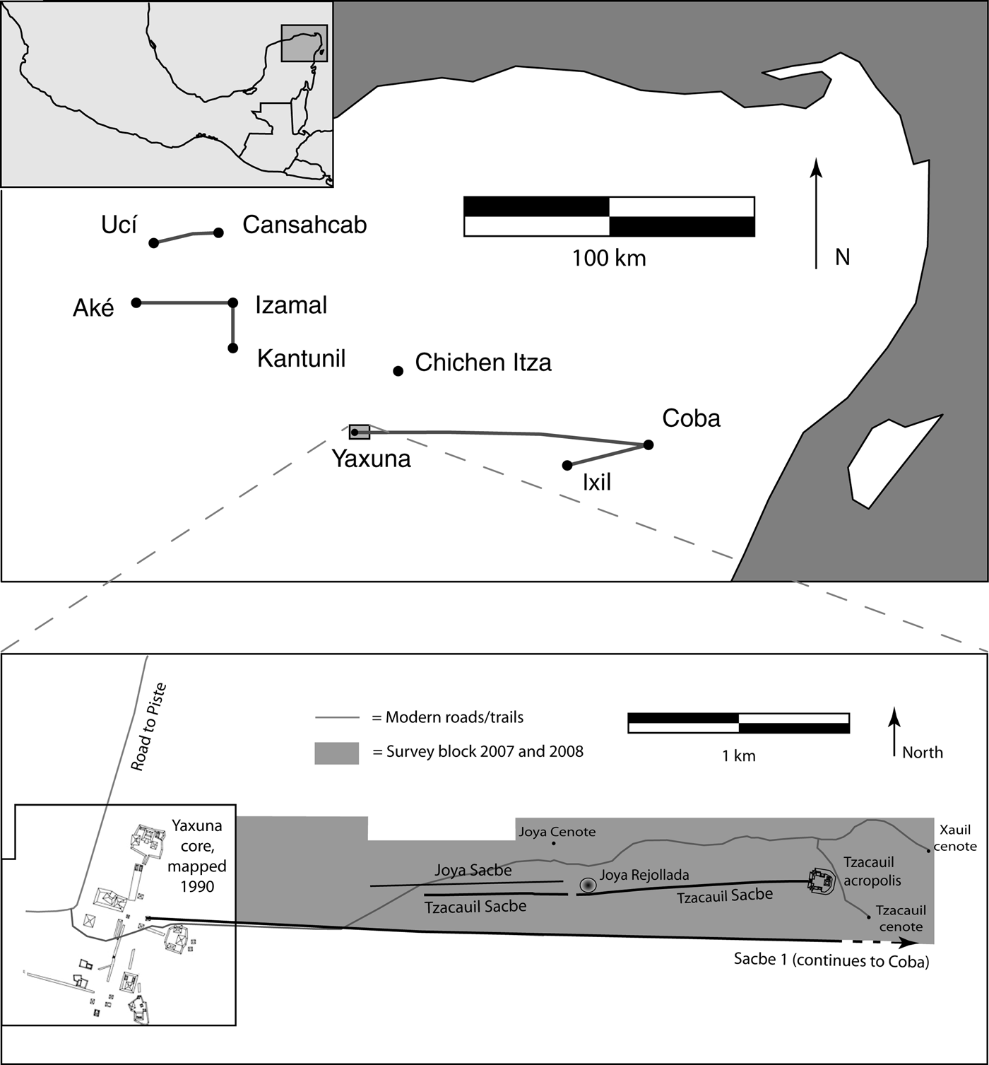
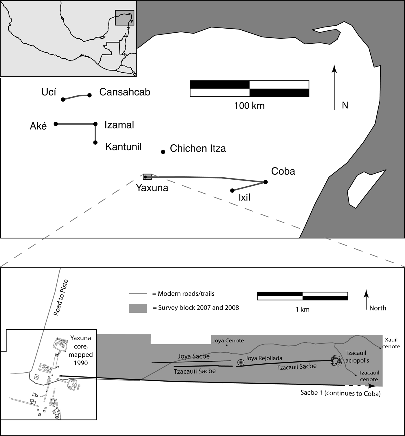
In this paper, we report the results of an archaeological survey to the east of the site of Yaxuna, located in the center of the Northern Maya Lowlands in the Mexican state of Yucatan (Figure 1). An intriguing feature of the settlement survey reported below is a stone causeway that begins from a massive Late Preclassic (250 b.c.–a.d. 250) acropolis among a small scatter of platforms—Tzacauil—and heads in the direction of a large Maya center—Yaxuna—but does not get there. Tzacauil and Yaxuna are distinct sites with unoccupied land between them. Though this causeway is solid, made of rock, it is merely a gesture toward solidity, a provisional built feature, not complete. The causeway provides a good example of Anthony Giddens' theory of structuration. As most archaeologists know, Giddens defines structure as rules and resources. Structure does not simply constrain action, it is produced in action. Structure is therefore dual, both medium and outcome of action (Giddens Reference Giddens1979, Reference Giddens1984:25). If structure is an outcome, it can be transformed in action and is therefore always in the process of formation. Structuration—the notion that social systems are produced and reproduced in action—is an ongoing process whose outcome is never guaranteed. The Tzacauil causeway provides a nice example of the uncertainty of outcomes: the fact that it stops short of Yaxuna shows that when it was under construction there was no guarantee that it would make it all the way to Yaxuna. Yet the Tzacauil causeway should not be seen merely as a failure. As we discuss below, the causeway is also an innovation. Regardless of where it ended, the causeway stretched a full order of magnitude longer than previous causeways in the region. More than just reproducing an existing category of monument, the people of Tzacauil transformed it, producing a new category.
Map of study region and survey area.
As an innovation, the Tzacauil causeway did not satisfy any logistical necessities nor solve any technological problems. Nonelevated paths would have served just as well for crossing the same terrain, even in the rainy season. These considerations focus our attention on the meaningful symbolic aspects of the causeway. In this paper, we suggest that the data lend themselves to a semiotic approach to meaning. We interpret the development of Tzacauil and its causeway toward Yaxuna not as an inevitable process in the political evolution of Yaxuna, but as the materialization of a daring political strategy with mixed results. The political landscape to the east of Yaxuna is therefore a relic of shifting and uncertain “relations of authority created within practices that demarcate difference, hegemony, exclusion” (Smith Reference Smith2003:115). In keeping with the theme of this paper, we caution that our interpretations are also uncertain. We share these tentative arguments with the hope that they will motivate further research in the region and inspire archaeologists working with data sets from other regions to consider the historical processes that structure and are structured by local political landscapes. The Tzacauil case study adds to several recent studies that have shown the potential of this approach (Gillespie Reference Gillespie, Mills and Walker2008; Joyce Reference Joyce2004; Pauketat and Alt Reference Pauketat, Alt, Van Dyke and Alcock2003).
CONCEPTUAL FRAMEWORK
When archaeologists engaged seriously with meaning in the early 1980s, structuralism provided a readily available approach (Hodder Reference Hodder and Hodder1982). However, archaeologists immediately recognized problems with structuralism (see Conkey Reference Conkey and Lamberg-Karlovsky1989). One critique of structuralism's application to material culture arose from the fact that it came to archaeology packaged with a very specific, narrow theory of meaning: Ferdinand de Saussure's semiology. In semiology, the relationship between the signifier (the object) and the signified (the object's meaning) is arbitrary. For example, there is nothing in the sound or appearance of the word “buffalo” that refers to a bovine. Social convention alone stabilizes this arbitrary/symbolic relation. Yet with material culture (as well as with language) (Silverstein Reference Silverstein, Basso and Selby1976), the relation between an object and its meaning is not always arbitrary (Hodder Reference Hodder1986, Reference Hodder1989). For example, the image on the back of an old nickel actually looks like a buffalo. Charles S. Peirce (Reference Peirce1998) used the term “iconic” to refer to this kind of a relation, in which the sign (the image of the buffalo) actually looks like the object (a bovine) to which the sign refers. In addition to arbitrary/symbolic relations and iconic relations, Peirce emphasized indexical relations, in which there is a relation of spatiotemporal contiguity between object and sign (Parmentier Reference Parmentier1994:6). For example, the hoof print of a buffalo can be recognized as a sign of the passing presence of a buffalo because the hoof and the mud were at one point spatio-temporally contiguous. (An iconic relation is also at work here since the shape of the hoof print matches the outline of a hoof.) Anthropologists refer to Peirce's work as a cornerstone in the field of semiotics, defined broadly as the study of signs (Preucel Reference Preucel2006:5). Peircian semiotics has only recently come into broader circulation in archaeology (Hodder and Hutson Reference Hodder and Hutson2003; Preucel Reference Preucel2006; Preucel and Bauer Reference Preucel and Bauer2001). Therefore, semiotics may seem a bit “bandwagonesque,” the latest in an interminable parade of short-lived trends. Some archaeologists have tired of such trends (Chippindale Reference Chippindale, Yoffee and Sherratt1993). This exhaustion would be understandable if the use of Peircian semiotics amounted not to new understandings of the past but to another layer of jargon, such as “dicent indexical legisign,” to take an example from Peirce. Semiotics, however, is not merely a passing trend. Since archaeologists cannot talk about the past without implicitly making assumptions about meaning, semiotics always pervades archaeological interpretation. To discuss semiotics in the context of central Yucatan is therefore not to impose exotic theory onto local data, but to focus explicit attention on something that has always been of interest: how people produce and understand a meaningfully constituted world.
Semiotics and practice theory fit each other remarkably well. The value of combining them is that semiotics, which deals deftly with material culture, can address what others have noticed as a shortcoming in practice theory's treatment of the physical world. To clarify the concept of semiotics and show how it articulates with practice theory, we now highlight additional differences between semiotics and semiology (see also Keane Reference Keane2003, Reference Keane and Miller2005; Preucel Reference Preucel2006; Singer Reference Singer1984). First, Saussure's model of the sign is dyadic, consisting only of signifier and signified. On the other hand, Peirce's theory is triadic. We have already identified two elements in Peirce's model: sign and object. The third element is the “interpretant.” These elements each appear in Peirce's definition of the sign: “something which stands to somebody for something” (Peirce Edition Project 1984, quoted in Preucel [2006:54]). The sign and the object—the first and the second “somethings,” respectively, in Peirce's quote—are easily understood, but the idea of the interpretant is more difficult to grasp. The interpretant is an effect or feeling that the sign produces in an interpreter. The inclusion of an interpreter (the “somebody” in Peirce's definition of the sign) in the sign relation represents a major breakthrough because people enter the picture. The presence of people brings up another fundamental difference between Peirce's semiotics and Saussure's semiology. When people are involved, things get messy, active, and unpredictable. The possibility for change arises, and historical context becomes important. Signs come to life. “Signs have a capacity to generate new signs” because their effect on people (the interpretant, the third part of the sign triad) can get people to create new objects and new signs (Bauer Reference Bauer2002; Preucel Reference Preucel2006:55). By contrast, Saussure's semiology is timeless. When meaning is dyadic (signifier–signified), with no room for a third party to misinterpret or reinterpret, it is difficult to understand how the meaning of a sign could ever change. In semiotics, signs are open to interpretations that can change their meaning.
As Keane (Reference Keane and Miller2005) makes very clear, the open-endedness of signs, their unpredictability, works well with theories of practice. Iconicity, one of three ways in semiotics that signs can relate to their object, illustrates this compatibility. Though we defined iconic relations above using the example of a buffalo nickel, we now switch to architecture because it is at the center of the case study below. An architectural drawing (the icon) shares a resemblance to an actual building (the object). However, an architect can make a drawing of a building that does not yet exist. Signs, such as the drawing, therefore have what Keane calls futurity: they have the potential to bring new ideas or relations into being. This potential, however, hinges on whether or not people are disposed to recognize it. Realizing potential requires the right interpretant: it depends on whether someone can convince people to actually build the building. Thus, whether or not the building gets built depends on how people interpret signs, on whether or not a leader can get people to recognize the value of the leader's ideas. This is what Keane calls a semiotic ideology. Analyses attuned to the possible presence of semiotic ideologies permit accounts of the past that involve power struggles and tension between different background assumptions, worldviews, and more.
When we as archaeologists look at a completed building, we sometimes overlook the fact that at one point, the building was just a plan and had no guarantee of getting built. Looking at a causeway that never got finished (such as the one at Tzacauil) or a wall that exists only as fragments (such as the one at Tikal) (Webster et al. Reference Webster, Murtha, Straight, Silverstein, Martinez, Terry and Burnett2007) helps us emphasize this and gets us to focus on processes and practices as opposed to finished products taken for granted, as if their existence was never in question (see also Bourdieu [Reference Bourdieu and Nice1990:12] on confusing the opus operatum with the modus operandi).
A final difference worth highlighting between semiology and semiotics is that semiology is modeled after language, whereas semiotics incorporates material culture. Bringing physical things into the picture (as opposed to just words [Saussure's signifiers] and concepts [Saussure's signifieds]) also provides a corrective to early theories of structuration. Sewell (Reference Sewell1992) has shown that Giddens' stance on material culture is incomplete. Giddens defines structure as rules and resources, but in other passages the solidity of these resources tends to melt away. For example, Giddens (Reference Giddens1984:377) makes the arresting claim that “structure exists only as memory traces.” As Sewell clarifies, structure cannot be entirely virtual: resources, such as factories, exist in the real world. In other words, all that is solid does not melt into air. Buildings have an existence that outlasts the intentions of their creators. As Parmentier (Reference Parmentier2009) notes, one of the difficulties of semiotic analysis in archaeology is that the analyst is not present at the moment in which ancient features are first interpreted. Yet the perseverance of artifacts is not lost on their creators (Parmentier Reference Parmentier2009; Preucel Reference Preucel2006). One of the peculiar features of material culture is that, unlike Saussure's signs, they do not so easily disappear. This underscores the need for what John Barrett (Reference Barrett, Ashmore and Knapp1999) calls an archaeology of inhabitation. Though the Tzacauil causeway did not reach as far as Yaxuna, and eventually fell into disuse, people could not ignore it. Thus, in the discussion, we will be attending not just to the role that the causeway played in the political strategies of its creators, but to the multiple and sometimes unintended ways in which the causeway impacted later processes.
RESEARCH BACKGROUND AND GOALS
The data in this paper come from an intensive survey transect east of the site of Yaxuna. Yaxuna first came to archaeologists' attention during the Carnegie Institution of Washington project at Chichen Itza, when Alfonso Villa Rojas (Reference Villa Rojas1934) confirmed that Yaxuna was indeed the site at the western terminus of a sacbe—a raised limestone causeway—that extends 100 km eastward to the site of Coba (Figure 1). George Brainerd (Reference Brainerd1958), the first to excavate and publish a map of the site, noted that Yaxuna had a large Preclassic occupation, now known to extend from 500 b.c. to a.d. 250 (Suhler et al. Reference Suhler, Ardren and Johnstone1998), as well as a Classic period occupation. From 1986 to 1996, David Freidel directed fieldwork at Yaxuna, focusing on the site's role in regional politics of the Northern Lowlands (Suhler and Freidel Reference Suhler and Freidel1998). Archaeologists from Mexico's National Institute of Anthropology and History continued work at Yaxuna after Freidel's project, consolidating many structures in the site core.
Research in the vicinity of Yaxuna began again in 2007 when the authors initiated the Proyecto Interacción Política del Centro de Yucatan (PIPCY). The chief goal of PIPCY is to build a micro-regional understanding of Terminal Classic political transformations. This multi-stage and multi-site project involves documenting the social, ritual, and political impact of the florescence of nearby Chichen Itza (Stanton et al. Reference Stanton, Hutson and Magnoni2008). The largest constructions we report in this paper, however, predate the Terminal Classic period. In fact, research conducted by Freidel's team confirmed Brainerd's earlier finding that Late Preclassic (250 b.c.–a.d. 250) constructions account for most of the volume of architecture in Yaxuna's site core (Stanton Reference Stanton2000; Stanton and Ardren Reference Stanton and Ardren2005; Stanton and Freidel Reference Stanton and Freidel2005; Suhler et al. Reference Suhler, Ardren and Johnstone1998).
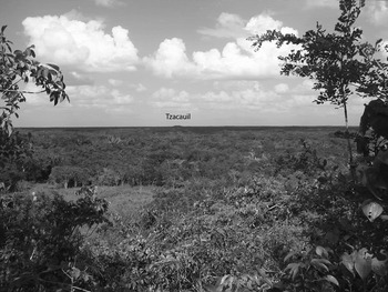
Tzacauil is a large structure to the east of Yaxuna—a tree-covered artificial construction jutting out from the forest floor, visible from the top of Yaxuna's East Acropolis as a bump on the horizon (Figure 2). It became clear on the first day of the 2007 field season that Tzacauil, situated 3.2 km from the center of Yaxuna, was an acropolis similar to other acropolis groups at Yaxuna. It also became clear that a raised limestone causeway departed from the west side of the acropolis, heading in the direction of Yaxuna. At the point where the causeway departs from the acropolis, it lies 276 m north of Sacbe 1, which connects Coba and Yaxuna (a distance of 100 km), and runs approximately parallel to the Tzacauil sacbe. At its terminus to the west, the Tzacauil causeway is only 130 m to the north of Sacbe 1. Sacbe 1 has been shown to date to the Late Classic period (Shaw and Johnstone Reference Shaw and Johnstone2001), which, as discussed below, is well after the abandonment of Tzacauil and its sacbe.
Tzacauil acropolis 3 km in the distance. Photo taken from the East Acropolis at Yaxuna.

The primary goal of the survey was to clarify the relation between Tzacauil and Yaxuna. We needed to know whether settlement was continuous between Yaxuna and Tzacauil. We also needed to know where the Tzacauil causeway ended and what form it took. We needed architectural details of the Tzacauil acropolis to compare it with the acropolises of Yaxuna and other sites. Other initial goals were to determine the nature of settlement to the east of Tzacauil, to document natural resources, and to understand patterning between human settlement and such resources.
METHODS
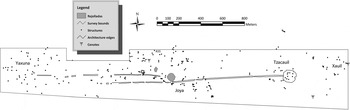
Survey and mapping to the east of Yaxuna took place during the summers of 2007 and 2008. The boundaries of the survey, shown in Figures 1 and 3, include Sacbe 1 to the south, the Xauil cenote (sinkhole reaching to open, standing water) to the east, arbitrary east/west lines to the north, and, to the west, the eastern edge of Freidel's map of the Yaxuna site core (Freidel et al. Reference Freidel, Suhler and Krochock1990). This edge lies 500 m east of the Yaxuna site center datum (next to structure 6E-14). In total we surveyed 143 ha. Figure 3 shows three areas where we documented structures beyond the bounds of the survey block. In two cases, these structures were visible from the edge of the boundary. In the third case, workmen led us to mounds 160 m north of the survey boundary.
Sites (Yaxuna, Joya, Tzacauil, and Xauil), structures, and other features investigated on the survey.

The survey method involved systematically walking across 100% of the survey block in teams of three to six people, with 10 m spacing between each person. Each walker was thus responsible for viewing five meters of terrain to either side. As is the case with most surveys in the humid lowlands, ceramic sherds were seldom visible. But the visibility of architecture is excellent in northern Yucatan. Natural sedimentation and soil formation processes consist mostly of the weathering of bedrock and wind-blown deposition of volcanic ash and Saharan dust and therefore rarely bury ancient stone foundations and stone platforms (Muhs et al. Reference Muhs, Budahn, Prospero and Carey2007; Perry et al. Reference Perry, Velazquez-Oliman, Socki, Gomez-Pompa, Allen, Fedick and Jimenez-Osornio2003). Thus, minimal colluviation and the absence of alluviation, given the generally flat topography, minimize the problem of invisible structures (Ashmore Reference Ashmore and Ashmore1981; Chase Reference Chase, Culbert and Rice1990; Folan Reference Folan, Folan, Kintz and Fletcher1983; Johnston Reference Johnston2004; Pyburn Reference Pyburn, Culbert and Rice1990). Bioturbation would affect stone architecture in the northern lowlands, but the shallow biomantle depth limits the degree to which architecture sinks and soil rises. We recognize that nonmounded structures made entirely of perishable materials would have been missed, but such structures may have been rare and may not have been dwellings (Tourtellot Reference Tourtellot1988:437). The close spacing between members of survey teams and the degree of visibility give us confidence in the representativeness of our survey, though no surveys are perfect (Healy et al. Reference Healy, Helmke, Awe and Sunahara2007:26). The quantity of land covered may pale in comparison to the much larger surveys in arid parts of Mesoamerica, but the more intensive nature of our survey ensures higher resolution, which enables close consideration of political processes (O'Brien and Lewarch Reference O'Brien and Lewarch1992).
Once structures and other features (sinkholes, wells, natural depressions, quarries, stone fence walls, grinding stones) were located, they were registered utilizing a geographical positioning system (GPS) and mapped with tape and compass. Surface collections were made at a sample of architectural groups. Surface collection methods varied depending on vegetation cover. In cases where the ground surface was not obscured by vegetation and sherds were visible on the surface, all sherds located within three meters of the structures were collected. In cases where the ground surface was obscured, 3 × 3 m collection units were established, vegetation cover was removed, and all sherds were collected. Only a small fraction of the structures located in the survey were collected in this manner, and several 3 × 3 m collection units retrieved no diagnostic sherds. Ten off-mound test pits measuring 2 × 1 m were excavated to bedrock at the center of the Joya site in the summer of 2011, though these excavations yielded few artifacts. These conditions underscore the provisional nature of the analysis that follows and the need for further excavation. We produced digital elevation models of a number of features, including the Tzacauil acropolis, two sacbes discovered during the survey, and a natural karst sinkhole classifiable as a rejollada.
RESULTS
The survey located 274 pre-Hispanic structures (most visible as dots in Figure 3) and a variety of other features. Most features pertain to three sites: Tzacauil, Xauil, and Joya. As discussed below, the extreme low density of structures between these sites enables us to consider them as distinct settlements. We discuss the Tzacauil sacbe separately.
Tzacauil
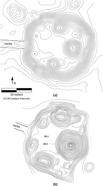
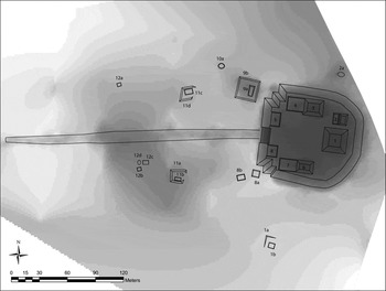
The Tzacauil acropolis dominates this site. Figures 4a and 5 present digital elevation models of the acropolis. The base of the acropolis consists of a platform that measures 80 × 70 m at the top and 110 × 105 m at the base. The orientation of the long axis is approximately 98°. The height of the platform varies from 8 to 8.5 m. A 2 m high bedrock outcrop on the northeast corner of the acropolis indicates that builders took advantage of natural rises in the topography. The stairway, approximately 20 m wide, ascends the west side, connecting with the Tzacauil sacbe at its base.
Topographic maps of the Tzacauil Acropolis and Yaxuna's East Acropolis.

Tzacauil Acropolis and surrounding structures, with structure labels. Darker shades indicate higher elevation.

The structures on top of the acropolis clearly conform to a common Late Preclassic plan: the triadic group (Hansen Reference Hansen and Houston1998). Of the three structures that form the triad, Structure 1 is the central structure, reaching an elevation of 6.5 m above the acropolis. Structures 3 and 6, which flank Structure 1 and face each other, rise between 4 and 3.5 m above the acropolis, respectively. Structures 3 and 6 each have low extensions stretching to the west. Three smaller structures stand atop the acropolis, two of which flank the stairway on the west side while the third, Structure 2, a split-level structure, lies to the north of Structure 1, at the northeast corner of the acropolis. The volume of the acropolis and the structures on top of it barely exceeds 80,000 m3. Surface collections from the top of the acropolis produced Late Preclassic ceramics.
Seventeen structures huddle within 150 m of the acropolis, bringing Tzacauil's total structure count to 28 (Figure 5). Most of the 17 nonacropolis structures are on the west side of the acropolis, the direction in which the acropolis faces and the direction toward which the sacbe runs. Though no surface sherds were seen around these structures, their close association with the Late Preclassic acropolis suggests they were contemporary with the acropolis. The people who lived here were most likely the support population for the acropolis. Thirteen of these 17 structures form six groups. Four of the groups consist of a basal platform supporting a single stone superstructure, most likely a house. The average surface area of the basal platforms is 234 m2, while the volumes are 86 m3, 176 m3, 206 m3, and 600 m3. The average surface area of the other 13 structures, mostly house foundations, is 26 m2.
The structures around the acropolis form a relatively discrete grouping. The closest cluster of structures to the west—a collection of 147 buildings named Joya (see below)—is nearly 600 m away. Between Tzacauil and Joya lie six scattered structures in a 30 ha area. Settlement density in between these two clusters is therefore 20 structures per km2, which is well below what has been considered typical of intersite settlement densities in Yucatan and elsewhere (Hutson et al. Reference Hutson, Hixson, Magnoni, Mazeau and Dahlin2008; Rice and Rice Reference Rice, Rice, Culbert and Rice1990). The most substantial of these structures is 15a, a basal platform measuring 14.7 × 13 × 1.3 m and supporting one superstructure. The superstructure and the other four structures are substantially smaller: none of these buildings measures more than 8 m on a side nor exceeds 30 m3 in volume.
Xauil
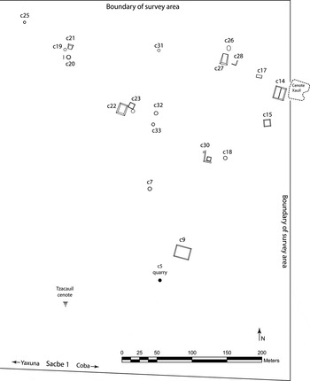
To the east of Tzacauil lies a stretch of unoccupied land ranging from 200 m to 320 m wide (see Figure 3). At the eastern edge of this empty zone begins a cluster of structures that collects around a cenote (Figure 6), not unlike the water-hole groups documented ethnographically in highland Chiapas by Vogt (Reference Vogt and Chang1968). The cenote is part columnar and part covered, following Houck's classification (2006:63). The cenote lends its name, Xauil, to this site. We mapped 25 structures at Xauil, though additional mounds to the east of the survey boundary and possibly to the north remain undocumented. Large quantities of slatewares in surface collections at the C22–C23 group and Puuc-style veneer stones found in one structure (C27) suggest that Xauil dates to the late part of the Classic period, not contemporaneous with the Tzacauil acropolis, which faces to the west, away from Xauil. Nevertheless, most of Xauil's architecture is not chronologically diagnostic. Excavations at groups with no surface ceramics are needed to refine the chronology.
Map of Xauil site.

Although the people living at Xauil form a spatially bound aggregate and share access to water from the cenote, none of the structures we mapped appear to have hosted administrative or ritual activities that would have helped integrate these people into an interactional community (Yaeger and Canuto Reference Yaeger, Canuto, Canuto and Yaeger2000:3). The largest structure, C14, measuring 16 × 14 × 1 m, is also the closest to the cenote. Although Structure C14 supports a superstructure, it does not combine with other mounds to delineate a plaza. Larger structures or compounds may be present to the east, beyond the survey bounds. The average surface area of the 25 structures is 61 m2. Removing the two basal platforms (C14, C27) and the C9 terraced hilltop gives an average of 37.4 m2. We found a small limestone quarry at the southern edge of the site (labeled C5 in Figure 6), though it likely did not serve many households. Another cenote, the Tzacauil cenote, classifiable according to folk taxonomies as cubierto, or covered (has only a small opening at the ground surface; Houck Reference Houck, Mathews and Morrison2006:62–63), sits 220 m southeast of the Tzacauil acropolis and 430 m southwest of the Xauil cenote. Figures 3 and 6 show no settlement clusters near this cenote, though people have drawn water from it in recent decades.
Joya
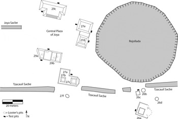
The crescent-shaped settlement cluster to the west of Tzacauil accounts for most of the features found during the survey (Figure 3). Locals use the name Joya to refer to the large rejollada (a dry karst sinkhole) (Houck Reference Houck, Mathews and Morrison2006) located near the center of the cluster (see Figure 7). A covered cenote and a second rejollada also lie near the center of the Joya settlement cluster (see Figure 3). Joya contains 147 pre-Hispanic structures within 0.38 km2, yielding a settlement density of 376 structures per km2. Assuming that the shape of this cluster is truly a crescent, another 7 ha of the crescent, containing perhaps another 25 structures, lie to the north of the survey boundary. To the south, west, and east, areas without settlement delimit the edge of the site. The stretch of unsettled land to the west between Joya and Yaxuna's east boundary measures about 300 m.
Map of the Joya site center, showing segments of the Tzacauil and Joya sacbes, the Joya rejollada, the structures around the site's central plaza, and the location of 2 × 1 m test pits.

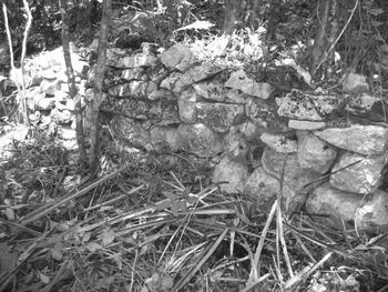
Unlike Xauil, Joya has an easily definable center consisting of a plaza measuring 58 × 32 m (Hutson et al. Reference Hutson, Magnoni, Stanton, Slater, Johnson and Harrison-Buck2012) (Figure 7). Joya has a sacbe that runs westward from the midpoint of the west side of the plaza. The sacbe's terminus at the midpoint suggests it was a formal part of the plaza design. The Joya sacbe joins the Tzacauil sacbe and Sacbe 1 as the third of three parallel sacbes to the east of Yaxuna. Like Sacbe 1 and in contrast to the Tzacauil sacbe, Joya's sacbe extends into Yaxuna (see Hutson et al. 2012). Eight 3 × 3 m surface collections and ten 2 × 1 m test pits were placed among the buildings surrounding the Joya plaza (Figure 7). These operations yielded very few ceramics. A small portion of the ceramics date to the Late Preclassic and the Early Classic periods, while most date to the Late Classic period and pertain to the Maxcanu, Arena, and Muna ceramic groups. A few stones on the ground in front of Structure 27e were carved in the Late/Terminal Classic Puuc veneer style. These data suggest that the Joya plaza and the Joya sacbe were built after Tzacauil and its sacbe. Several buildings beyond the Joya plaza are well preserved. For example, one of Structure A55's platform retaining walls has six courses of stone preserved up to 1.2 m high for a length of 8 m (Figures 3 and 8).
Well-preserved wall of Structure A55, Joya site.

None of Joya's structures are monumental. The largest structure by volume—A6, a basal platform supporting other superstructures—measures 30 × 20 × 2 m and is located 150 m west of Joya's central plaza. The average surface area and volume of Joya's 16 basal platforms are 361 m2 and 408 m3, respectively. These figures are larger than those for Tzacauil. The average surface area and volume of the other 131 structures is 53 m2 and 31 m3, respectively.
Tzacauil Sacbe
Though we assume that the Tzacauil sacbe was built at the same time as the acropolis to which it connects, this has yet to be supported with radiocarbon dating (Van Dyke [Reference Van Dyke2004:424] notes that in Chaco Canyon, New Mexico, roads were occasionally built to abandoned settlements). Beginning at the Tzacauil acropolis, this sacbe measures 9 m wide with a height of 0.8 m, but elsewhere the width varies from 6 m to 10 m, and the height varies between 0.3 m and 0.5 m. Crudely cut facing stones line portions of the edges of the sacbe; near its beginning the sacbe has a lower step visible for a few meters. This lower step is diagnostic of Preclassic period sacbes at Yaxuna (Lourdes Toscano, personal communication 2006). The initial orientation (270°) puts the sacbe on a collision course with the Joya rejollada, yet the builders engineered a slight curve to the south after 100 m, putting it on an azimuth of 264°. The sacbe then changes back to its original orientation 900 m west of the acropolis. Though builders of causeways at many sites made every effort to avoid changes in orientation, several sites have examples of causeways that bend in order to avoid natural features (Shaw Reference Shaw2008:68). For the final few hundred meters, the sacbe follows an orientation of 268°. The sacbe terminates approximately 1,700 m to the west of the acropolis. Folan and others have used both archaeological and ethnohistoric/linguistic data to enumerate various kinds of paths, sacbes, and other routes (Folan et al Reference Folan, Hau, Marcus, Miller and Heredia2001; Bolles and Folan Reference Bolles and Folan2001). The details of the Tzacauil sacbe do not easily place it into the four general categories of sacbe (regional, state, urban, and neighborhood) discussed by Folan. A sacbe of this length falls into Shaw's (2001, 2008) category of core-outlier sacbes, from 1 to 5 km, but the sacbe could be considered part of Shaw's intersite category since Tzacauil and Yaxuna are very distinct settlements.
The sacbe does not have a formal endpoint. Rather, it makes an initial stop 1,570 m from the acropolis, but a few meters beyond this stopping point lies an elliptical stone foundation brace measuring 3 × 1.5 m, and approximately 15 m further to the west (at 1,600 m west of the acropolis), the sacbe starts again as a crude, 25 m long alignment of stone rubble. A second crude alignment of rubble extends beyond the first, stopping 1,670 m to the west of the acropolis. Finally, a 10 m long scatter of medium-size stones was found at 1,700 m west of the acropolis. This is the last sacbe fragment we were able to document, and it is located 1,460 m east of the Yaxuna site center datum and 130 m north of Sacbe 1. These small sacbe fragments may indicate that different work groups were responsible for constructing different sections (Bolles and Folan Reference Bolles and Folan2001:307; Shaw Reference Shaw2008:67). There are no structures in the immediate vicinity of this uncertain endpoint. The nearest structure is an 18 × 14 × 0.4 m platform with a superstructure located 55 m to the northwest. The next closest settlement is a pair of structures 60 m to the northeast. These structures represent the western edge of Joya.
The Tzacauil causeway is not the only one in Yucatan that ends abruptly without connecting to structures, but other examples are rare. Sacbe 26 at Coba is unfinished (Bolles and Folan Reference Bolles and Folan2001:307), and several sacbe fragments not connected to sites have been documented in the vicinity of Calakmul (Folan et al. Reference Folan, Marcus and Miller1995, Figures 3 and 4). At Chunchucmil, two sacbes begin from multifamily residential compounds and extend 60 and 100 m away from the site center before stopping (see Hutson et al. Reference Hutson, Hixson, Magnoni, Mazeau and Dahlin2008, Figure 4c). Along the north coast of Yucatan, raised stone walkways begin from coastal sites and cross marshy areas to the south but end far short of nearby sites (Miguel Covarrubias Reyna, personal communication 2008). At Uci (see Figure 1), a sacbe from the center of the site runs 1.2 km to the west and stops at a bedrock outcrop with no apparent cultural modification (Hutson Reference Hutson2009).
We now consider the possibility that the Tzacauil sacbe continued further to the west than is visible today, perhaps even to the Yaxuna site core, like Sacbe 1. This assertion presumes that the sacbe did not preserve in the vicinity of Yaxuna due to later prehistoric scavenging for construction material. We contend that scavenging leaves a clear material signature and that the Tzacauil sacbe lacks this signature at the locale where it ends. The material signature for scavenging shows clearly on other portions of the Tzacauil sacbe. For example, the center of the Joya site was built around a portion of the Tzacauil sacbe. Chronological data discussed above suggest that the Joya center postdates the Tzacauil sacbe. As the map in Figure 7 shows, when a platform was built within 5 m of the sacbe, there is a gap at that particular spot in the sacbe. There are no formal facing stones on the sacbes at the edges of these gaps: rather, stones are missing, and fill from the sacbe spills into the void. Parsimony permits the conclusion that the builders of the newer platforms created these gaps by taking stone directly from the sacbe and using it for the platforms. If such scavenging occurred at the western terminus of the Tzacauil sacbe, we should see gaps in the sacbe and newer structures adjacent to these gaps. However, the Tzacauil sacbe disappears almost completely, and there are no structures close by to suggest scavenging.
DISCUSSION
We now consider political dynamics as inferred from the results presented above, focusing on Tzacauil and its sacbe. We stress again that these inferences are provisional. As Stark (Reference Stark1999) has framed the problem, the task is to understand the relation between a monumental complex (Tzacauil) and a nearby center (Yaxuna). One possibility proposed by Stark (Reference Stark, Sanders, Mastache and Cobean2003) is that the monumental complex is the country estate of landed elites. The complexes discussed by Stark, however, are much smaller in volume than Tzacauil.
Rather than a country estate, Tzacauil may instead represent actual dispersal of political power, a possibility Stark also notes. The triadic group atop the Tzacauil acropolis closely resembles contemporary triadic groups at the core of Yaxuna. A comparison with Yaxuna's East Acropolis (Figure 4b) drives home this point. Tzacauil and Yaxuna's East Acropolis relate iconically to one another. One explanation of this similarity is that Tzacauil was a secondary center charged with the duty of administering Yaxuna's eastern hinterland. The close similarity would be an example of a secondary site replicating institutions at the primary center, as has been argued for Monte Albán's administrative outposts in the Valley of Oaxaca (Blanton et al Reference Blanton, Kowalewski, Feinman and Appel1981:89; Marcus and Flannery Reference Marcus and Flannery1996:182–183). Data from the settlement survey suggest that Tzacauil did not carry out administrative duties on behalf of Yaxuna. There is very little Late Preclassic settlement around Tzacauil in need of administration (chronological data from nearby Xauil point to a noncontemporaneous Late or Terminal Classic occupation). Furthermore, in archaeology, the notion of secondary centers acting in concert with primary centers derives from central place models that presume an economizing logic. In central place theory, site hierarchies will be organized spatially in such a way that different types of work (administration, marketing, etc.) can be performed most efficiently (Johnson Reference Johnson1973). Tzacauil does not fit this logic of efficiency. In a central place model, secondary centers are located in such a way that they can administer populations that are distant from the primary center and therefore not efficiently administered by the primary center. Yet Tzacauil is a 30-minute walk from Yaxuna; administrators responsible for settlement further to the east could just as well have resided at Yaxuna itself. Finally, the construction of the Tzacauil sacbe required a large expenditure contradictory to any economizing logic.
Other explanations may also account for why a minor center like Tzacauil would be located so close to a major center like Yaxuna. According to Underhill et al. (Reference Underhill, Feinman, Nicholas, Fang, Luan, Yu and Cai2008:11), such closeness may reflect “a deliberate strategy of elites to control labor and the movement of subsistence goods (raw materials and/or finished goods) to the center.” Underhill draws on this explanation to account for the clustering of minor centers such as Dantu only 2 km distance from Liangchengzhen, the major center of the Shandong province in Northeast China during the Early and Middle Longshan period (2600–1900 b.c.).
Explanations involving secondary centers and the control of labor and goods are top-down in the sense that they would both explain Tzacauil with reference to the needs of authorities at Yaxuna, the regional center. Such top-down approaches can be supplemented by an approach that addresses the dynamic political processes that create such hierarchical relations between center and periphery. In central place theories, as deployed by archaeologists within evolutionary models, secondary centers appear as the inevitable and often universal result of the growing needs of the central place, be it Early Dynastic Eshnunna in Iraq (Flannery Reference Flannery1972; Johnson Reference Johnson, Ucko, Tringham and Dimbleby1972), or Late Classic Calakmul in Mexico (Marcus Reference Marcus1973). Studies using central place theory often overlook the local level processes involved in the constitution of political authority (Smith Reference Smith2003). There is indeed a place for local level strategies and dynamics in centralized models. The emergence of elite expression beyond the principal group at Copan in the Late Classic period (Fash Reference Fash, Andrews and Fash2005), for example, suggests that centralized political landscapes can also contain local strategies not fully dictated by the central place (Plank and Maca Reference Plank and Maca2006). Though the quadripartite layout of Yaxuna's site core at the end of the Preclassic period (Stanton and Freidel Reference Stanton and Freidel2005) implies a degree of centralized coordination, this does not preclude a less centralized, segmentary view of Preclassic politics (Fox and Cook Reference Fox and Cook1996; Ringle Reference Ringle, Grove and Joyce1999).
Following a dynamic model of political landscapes, we argue that Tzacauil's leaders played an active role in the constitution of power. Monuments may be interpreted as indexical signs of power since the quantity of stone and labor required to build them presumes the presence of leaders with great command of resources (Trigger Reference Trigger1990; compare against.Pauketat Reference Pauketat, Dobres and Robb2000). Yet this approach does not consider the specific history or iconicity of triadic groups. Recent research on Early Classic carvings from the C-9 triadic group at Naranjo, located in the Peten, Guatemala, suggests that Naranjo's dynastic rulers, the Sa'al lords, whose claimed lineage extends to the Preclassic period, identified themselves with this particular triadic group (Tokovinine and Fialko Reference Tokovinine and Fialko2007). Though these historic texts date to the Classic period, the group itself has a Preclassic period core. The Naranjo data show that the ancient Maya themselves wrote of the connection between rulership and triadic groups. The best preserved example of a triadic group is group H of Uaxactun, also located in the Peten. The ‘mat’ icons at the entrance to the group (Valdés Reference Valdés1992) may encode an indexical relation to rulership here and elsewhere in the Maya area since rulers, sometimes glossed as “of the mat,” sit on mats. Furthermore, Group H's zoomorphic masks permit the interpretation of this compound as a stage for royal rituals that create and consolidate power (Schele and Freidel Reference Schele and Freidel1990). Finally, Freidel and others (Freidel et al. Reference Freidel, Schele and Parker1993:140; Hansen Reference Hansen and Houston1998) note that the triangular arrangement of the three structures in triadic groups is an iconic reference to the three hearthstones of creation. If we accept the premise that triadic groups recall the creation, leaders who perform rituals within them can claim to play a role in creation and the birth of maize, thus moving followers to perceive a relationship of indebtedness.
Such posturing may have had many different goals. The close similarity between Tzacauil's acropolis and acropolis groups in the core of Yaxuna suggests the centripetal and centrifugal forces of the theater state model, in which lesser centers put on ritual performances identical to those of greater centers (Geertz Reference Geertz1979). In this model, Tzacauil's goal would be to siphon followers from other locales. Tzacauil's acropolis and triadic group are not, however, smaller versions of those at Yaxuna. There were a number of triadic groups in Yaxuna's core during the Preclassic period. Each of these may have been the headquarters of a faction vying for prestige and political control (Lucero Reference Lucero2007; Stanton Reference Stanton2000). By building their own triadic group, Tzacauil's leaders may have sought to become an equal player in these struggles. Testing these interpretations should include broad scale excavations on the Tzacauil acropolis in order to detect evidence of theater-state performances (Geertz Reference Geertz1979) or competitive feasting (Dietler and Hayden Reference Dietler and Hayden2001).
One line of evidence already available—the Tzacauil sacbe—suggests that Tzacauil's leaders did indeed seek inclusion in the higher stakes power dynamics at Yaxuna, as opposed to contenting themselves with their station as an outpost. At first glance, this sacbe appears to have been an attempt to connect Tzacauil to Yaxuna. This was no ordinary sacbe, however. Understanding the nature of this sacbe requires putting it into historical context.
The vast majority of sacbes in the Maya lowlands are less than 200 m long (Shaw Reference Shaw2001). In the Classic period, polities in the northern lowlands built longer sacbes, enabling a variety of classifications of sacbes by length and other features (Benavides Reference Benavides Castillo1981, Normark Reference Normark2006, Shaw Reference Shaw2008). In the Late Preclassic period, at the time when the Tzacauil leaders were building what would become a 1.6 km-long sacbe, causeways of this length were rare, limited (as far as we know) to the Mirador Basin (Hansen Reference Hansen1991), over 300 km to the south of Yaxuna. Thus, to most people in the vicinity of Yaxuna, the kind of long sacbe that the leaders at Tzacauil attempted to construct would have been a novelty. Any discussion of the origins of Tzacauil's sacbe therefore treads ground considered by Rosemary Joyce (Reference Joyce2004) in her essay on the origins of monumental architecture. Yet whereas Joyce argues that the first monumental architecture in Mesoamerica had no precedent and therefore may have been an unintended consequence of building practices, short causeways dating back to the Middle Preclassic period did exist at Yaxuna (Stanton Reference Stanton2005) as a precedent for the attempted longer causeway at Tzacauil in the Late Preclassic period. Thus, the construction of the Tzacauil causeway represents not the creation of a totally new thing, but an attempt to transpose and transform an already existing thing (Sewell Reference Sewell1992:17). More specifically, the sacbe as an architectural form connecting buildings within a site core, a form that had not yet extended more than 300 m at Yaxuna, was being creatively extended to potentially ten times that length to fit a new context and cause: connecting one site to another. Tzacauil was not alone in experimenting with new, sacbe-like features. Anderson's (Reference Anderson2010) recent mapping of Xtobo, a Middle and Late Preclassic site in the northwest corner of Yucatan, has uncovered a unique ring feature, 300 m in diameter, built of what appear to be sacbe fragments.
But what might such a sacbe have meant in the Late Preclassic period? What might the Tzacauil leaders have intended in transposing an older form—the sacbe—to a new purpose—bridging two sites? Combining ethnohistoric, iconographic, archaeological, and other lines of evidence, Bill Ringle (Reference Ringle, Grove and Joyce1999) has argued that Preclassic period causeways were used in processions that enact an ideology of inclusion. Preclassic causeways tend to connect central temples with locales slightly beyond the center. Ringle likens procession along causeways to the common Maya biological/cosmological trope of the circulation of the life force, or ‘ch'ulel,’ from heart to extremities. The circulation of this life force, a metaphorical kind of blood, renews life. Using Turner's ritual process, Ringle equates the circulation from center to periphery with a journey from a cultural core to a liminal, natural wilderness. Returning from the periphery to the center renews life but also synthesizes center and periphery. Procession along the sacbe imitates this movement from core to periphery and back. The sacbe as a sign of inclusion works both symbolically and indexically. It is a symbol because the relation between a stone causeway and the circulation of the life force is arbitrary. It is an index of inclusion because the construction of the causeway physically brought about interaction and contiguity between the sacbe's two endpoints (center and periphery).
Ringle's interpretation suggests that, in attempting to connect Tzacauil to the Yaxuna core by a sacbe, Tzacauil's leaders intended to signify their inclusion in Yaxuna's circle of political power. The way this signifying act actually played out encourages a semiotic approach to the builders' intended meaning. As discussed above, semiotic approaches to meaning are open-ended. The Tzacauil sacbe demonstrates this in two ways. First, signs can lead to new signs (Keane Reference Keane and Miller2005:186). The Preclassic sacbes in the Yaxuna site center connect triadic groups to the site core. If the leaders of Tzacauil wanted to become a political force or express their status as one, they may have felt that they, too, needed a sacbe to connect themselves to the Yaxuna core. In the semiotic triad, the sign is the sacbe, the object of the sign is political connectedness, and the interpretants are Tzacauil's leaders. The sacbe impressed itself upon the leaders as a way to enact their political aspirations of playing a role in local authority. But to get to Yaxuna, the leaders of Tzacauil needed a sacbe much longer than those already in existence. So they built a much longer one, and in the process transformed the category of sacbe from a short avenue within the core of a site to a long avenue that stretches between and across multiple sites. Thus, refracted through the interpretant, one sign gives life to a new sign.
We now discuss the second way in which the Tzacauil sacbe illustrates the open-endedness that a semiotic approach can give to material culture. In semiotics, interpretation of signs is open-ended; it is a matter of negotiation. Signs have an uncertain future: they depend on social context to secure their meaning (Bauer Reference Bauer2002). In the case of the Tzacauil sacbe, for whatever reason, people did not finish building the sacbe. Following Keane (Reference Keane and Miller2005), the futurity of this project was never secure. It was open to negotiation and challenge. It reached half the distance to Yaxuna's site center and, in the middle of nowhere, faded out in desultory, incomplete segments. There are many potential reasons why the Tzacauil sacbe never made it all the way to Yaxuna, none of which can be favored at this point. An archaeologically invisible, unbuilt path may have continued westward to Yaxuna. War or disease may have halted the project. Perhaps the Tzacauil leaders decided, in the middle of construction, that the sacbe did not need to go all the way to Yaxuna to be effective as a sign. On the other hand, it may be that leaders at Yaxuna forbade the sacbe to get any closer to their site.
Alternatively, as an expression of resistance, the people who provided the labor for constructing the sacbe may have given up on the project. This speaks to a failed semiotic ideology in which the justifications for completing the causeway were not compelling. Though building the acropolis and causeway seemed compelling when construction began, leaders could not convince workers to complete the plan, to convert sign to object. In Peirce's parlance, a new interpretant arose; the meaning of the sign changed as it spread among new people with different experience than the leaders, and the idea of the sacbe was not favorably received in this new context (Bauer Reference Bauer2002; Parmentier Reference Parmentier1994:10). The Tzacauil sacbe resembles the fragmentary, apparently unfinished state of Tikal's earthworks. Webster et al. (Reference Webster, Murtha, Straight, Silverstein, Martinez, Terry and Burnett2007) suggest that local leaders were unable to get outlying communities to commit to the work project and perhaps that that the leaders were not as powerful as once thought (compare against Silverstein et al. Reference Silverstein, Webster, Martinez and Soto2009).
It should be noted that the volume of stone used to construct the Tzacauil acropolis was about 15 times greater than that used to construct the sacbe, implying a much smaller labor commitment for the sacbe. Thus, completing the sacbe would have required relatively little labor. It would thus seem odd that Tzacauil's laborers would have put in so much work to complete the acropolis but then refused to provide a bit more labor to complete the sacbe. Such disobedience, however, might have been an unintended consequence of the construction of the acropolis. The acropolis project may have been pitched as an undertaking with communal benefits. When completed, however, the laborers may have been alienated from the acropolis, exposing it as an instrument that created or reinforced the worker's subordination (i.e., the “tragedy of the commoners”) (Pauketat Reference Pauketat, Dobres and Robb2000; see also Clark Reference Clark, Joyce and Hendon2003:61; Joyce et al. Reference Joyce, Bustamante and Levine2001). Perhaps this unintended alienation spurred the work stoppage.
Whatever the reason for why it was not completed, the premature termination of the Tzacauil sacbe illustrates that transposing an old form to a new context has risks (Sahlins Reference Sahlins1987). By attempting to transform the cultural category of sacbe, the Tzacauil leaders, as Sahlins would have put it (1987:x), ceased to become slaves to their concepts and sought to become masters. Yet modifying a cultural category—taking the idea of the sacbe and stretching it at least ten times its normative length so that it extended all the way from Tzacauil to Yaxuna—was a stretch, both literally and figuratively. In the end, the leaders did not master the situation.
Yet even though the sacbe failed to reach a notable destination and therefore may not have been used as intended, this does not mean that it had no consequences whatsoever. Here we enter an archaeology of inhabitation, which considers how people engaged with the built landscape and how old features participated in new processes, regardless of why a feature was originally built (Barrett Reference Barrett, Ashmore and Knapp1999; Hendon Reference Hendon2010). In semiotic terms, the sacbe as sign loses its initial symbolic meanings (among them a proposal of political connectedness) but retains its indexical meanings; indexical signs keep a meaningful relation to their object even if people cease to recognize the index as a sign (Parmentier Reference Parmentier1994:6). Though unfinished, the sacbe did not melt into air, mutely entering archaeological context as a forgotten ruin. We propose that the sacbe projected into people's lives even when in disuse and that it motivated new constructions. The portion of the sacbe that did get built had an impact well after it was built because it regionalized a previously unmarked space. For Giddens (Reference Giddens1984:118), regionalization transforms a less differentiated space into a more differentiated space. The sacbe accomplishes this in many ways. It divides an open space into two sides: the north side of the sacbe and the south side. The sacbe also directs attention to the east where it begins and to the west where it ends. To the east, of course, is the massive acropolis. The sacbe, emanating from that acropolis, indexes the strategies and once potent authority of those affiliated with the acropolis. Thus, as the sacbe projects westward, politics and power project themselves as well, materialized by the sacbe. The fact that the sacbe is merely provisional, that it falls short of its presumed destination, does not reveal itself except at its end point.
When we say that the sacbe motivated new constructions, we propose that, despite its failure to stabilize Tzacauil's provisional claims to authority, it succeeded in transforming structure. Following the logic of structuration, in which actions produce and reproduce the conventions that guide new actions, the act of experimenting with the length of sacbes transformed the category of sacbe. In the end, it became possible to build long sacbes that did not exist before. (Followers of Peirce may recognize this as a sinsign generating a legisign.) The Tzacauil sacbe experiment was not forgotten, but rather served as the model for the Joya sacbe, built parallel to the Tzacauil sacbe at a distance of 60 m to the north, which did succeed in connecting Joya to Yaxuna. Moreover, the Tzacauil sacbe, the first long sacbe in the northern lowlands, may have served as a model for even longer sacbes such as Sacbe 1 between Yaxuna and Coba or the sacbes in the vicinity of Izamal (32, 18, and 12 km long, respectively), located only 60 km to the northwest. Though the Tzacauil sacbe resembles the Tikal earthworks in the sense of its fragmentary, unfinished nature (Webster et al. Reference Webster, Murtha, Straight, Silverstein, Martinez, Terry and Burnett2007), the Tikal earthworks contrast sharply in that no later communities attempted to build anything quite like them.
CONCLUSION
The survey to the east of Yaxuna documented three new sites (Tzacauil, Xauil, and Joya) and two new sacbes (one anchored at Tzacauil, the other at Joya). Both Tzacauil and Joya have evidence of Late Preclassic occupation, though Joya is larger and longer-lived. Xauil was occupied in the Late and/or Terminal Classic period. The most conspicuous structure in the survey is the Tzacauil acropolis, which supports a triadic group. A sacbe began at the western edge of the acropolis and ended 1,700 m to the west without reaching a clear destination. The fact that a raised causeway was not necessary to get from Yaxuna to Tzacauil suggests that this sacbe carried political and/or religious meaning. In this paper, we have argued that the leaders of Tzacauil attempted to become a faction vying for authority at Yaxuna, a regional center during the Preclassic period. We also argue that the unfinished sacbe indicates that these attempts were not entirely successful. This result is not a surprise given that the projected sacbe was much longer than any previous sacbe in the area, already exceeding the expectations of what was intelligible and feasible.
We have used a semiotic approach to interpret the causeway. This approach works particularly well with material culture and, because of its compatibility with structuration theory, provides a framework for understanding innovations such as the unprecedented appearance of the long sacbe. The sacbe's abrupt termination highlights the fact that all practices involve risk, especially those practices that transpose familiar structures to unfamiliar contexts. This risk exposes an instability that exists on multiple levels. Not only are durable aspects of the built environment never guaranteed to bring about the kind of authority intended, but the norms and conventions are also subject to being broken or cited in unpredicted ways (Butler Reference Butler1993). Thus, both aspects of structure—rules and resources—risk melting, a condition that characterizes all social action.
RESUMEN
Este ensayo presenta una aplicación de la teoría semiótica de C.S. Peirce y la teoría de estructuración de Anthony Giddens a los resultados de un recorrido sistemático hecho a pie al este del sitio arqueológico de Yaxuna, en el estado de Yucatan. Los datos de este recorrido sugieren que un grupo localizado en el sitio de Tzacauil compitió por la influencia política en la época preclásica a través de la construcción de una acrópolis a tres kilómetros de Yaxuna. Este grupo también inició, pero no concluyó, una nueva construcción experimental: un sacbé de larga distancia entre Yaxuna y la acrópolis de Tzacauil. Un aspecto central en la teoría de estructuración es la inestabilidad en las prácticas sociales. Las reglas pueden cambiar cuando se transponen a contextos nuevos. Al mismo tiempo, los recursos duraderos, como son calzadas y grupos de acrópolis, no aseguran la estabilidad de las coaliciones que se forman para construir estos edificios. A pesar del gasto de recursos y de mano de obra, como nunca antes visto al este de Yaxuna, Tzacauil fue eclipsado por un sitio vecino llamado Joya. Aunque nunca terminaron de construir la calzada, la gente de Tzacauil sí tuvo éxito en transformar el concepto convencional de calzada. Estos acontecimientos apoyan la perspectiva semiótica porque muestran que la materialidad es contingente: tiene el potencial de que la gente involucrada puede o no trabajar para lograrlo.
ACKNOWLEDGMENTS
The research discussed in this paper was supported by two separate funds within the College of Arts and Sciences at the University of Kentucky, as well as the Selz Foundation. Carrie Todd, Matt Davidson, Leigh Anne Ellison, Henrik Petersson, and Trent Stockton worked hard to help acquire the data discussed in this paper. We thank Don Ignacio, the comisario ejidal of Yaxunah, for facilitating the survey of Yaxunah ejido land and the Consejo de Arqueología (INAH) for permits. Different versions of this paper were presented at Harvard University, the University of Colorado at Boulder, and the University of Kentucky. Archaeologists at all three of these institutions greatly improved this paper with their valuable feedback. Hutson thanks Jamie Forde (Colorado) and Jason Ur (Harvard) for facilitating visits to their departments. We thank Elizabeth Graham and an anonymous reviewer well versed in semiotics for useful suggestions for revision.