

Introduction
During the European Later Bronze Age (LBA hereafter; 1500–600 bc), raw and finished commodities, including copper, gold, tin, amber, and faience, flowed across Europe at scales previously unseen (Pare, Reference Pare and Pare2000; Cunliffe, Reference Cunliffe2001; Kristiansen & Larsson, Reference Kristiansen and Larsson2005; Harding, Reference Harding2007; Ling et al., Reference Ling, Hjärthner-Holdar, Grandin, Billström and Persson2013, Reference Ling, Stos-Gale, Grandin, Billström and Hjärthner-Holdar2014). Along the Atlantic coast of Europe, stretching from Iberia to Scotland, the sea and coastlines took on an increased socioeconomic importance as new and more sophisticated seafaring technologies opened maritime corridors to new communities and facilitated cultural mobility (Wright et al., Reference Wright, Hedges, Bayliss and van de Noort2001; Van de Noort, Reference Van de Noort2004, Reference Van de Noort, Fokkens and Harding2013; Clark, Reference Clark2005). A key mechanism for social transformation in Bronze Age Europe was the expansion of long-distance exchange systems, fuelled by the growing demand and increased access to metals and other exotics for economic, social, and political purposes (e.g. Earle & Kristiansen, Reference Earle and Kristiansen2010; Earle et al., Reference Earle, Ling, Uhnér, Stos-Gale and Melheim2015). The interface between these continent-scale processes and local developments along the Atlantic seascape remain poorly understood.
The small islands off the central-western coast of Ireland were linked with, and were affected by, the expansion of maritime networks in the LBA. Traditionally, islands have been conceptualized as disconnected and separate, with water seen as a barrier restricting social and economic interaction (see Fitzpatrick, Reference Fitzpatrick and Fitzpatrick2004). Small coastal islands in particular have been assumed to be marginal, i.e. landscapes that are peripheral to other areas in terms of environmental, demographic, geographic, and social factors, and, being surrounded by water, they have often been treated as neither accessible nor usable areas (see Dwyer, Reference Dwyer, Horning and Brannon2009). Recently, researchers have re-conceptualized islands as part of integrated seascapes where water is both a conduit and a barrier to cultural mobility (Cooney, Reference Cooney2004; Phillips, Reference Phillips2004; Van de Noort, Reference Van de Noort2004; Rainbird, Reference Rainbird2007; Thompson & Turck, Reference Thompson and Turck2010; O'Shea, Reference O'Shea2011).
Revising our perspective of Ireland's islands and coastal areas as part of an integrated seascape allows us to better understand how the development of Bronze Age long-distance exchange networks transformed environmentally marginal seascapes into an important corridor of human interaction and movement of goods and people (Sherratt, Reference Sherratt1993; Mount, Reference Mount and Henderson2000; Cooney, Reference Cooney2004; Van de Noort, Reference Van de Noort2004, Reference Van de Noort2011; Phillips, Reference Phillips2004; Frieman, Reference Frieman2008; Needham, Reference Needham and Clark2009). Larger regional centres, such as Dún Aonghasa (Cotter, Reference Cotter2012), as well as the flow of exotic commodities such as metal (e.g. Henderson, Reference Henderson2007: 57–98; Waddell, Reference Waddell2010: 231–32; Ling et al., Reference Ling, Hjärthner-Holdar, Grandin, Billström and Persson2013, Reference Ling, Stos-Gale, Grandin, Billström and Hjärthner-Holdar2014), have been a major focus of Bronze Age archaeological research on the west coast of Ireland. Settlements on smaller islands have received comparatively less attention. It is important to (1) demonstrate that small coastal islands were occupied during the LBA and (2) explore the relationship among small island communities, larger regional centres, and maritime trade systems. To do this, we combine an intensive study of a small island, Inishark in County Galway, Ireland, with a broader discussion of social, economic, and political dynamics in the western Irish seascapes during the LBA. In order to connect local Irish archaeological sequences with continental-scale processes, we frame the chronological span of our research in line with other European researchers and adopt the LBA terminology most recently employed by Ginn (Reference Ginn2016) to encompass the second half of the Middle Bronze Age and entire Late Bronze Age as part of the three-phase chronological system used in Ireland (see Roberts et al., Reference Roberts, Uckelmann, Brandherm, Fokkens and Harding2013; Ginn, Reference Ginn2016: 39).
This article presents the results of integrative multi-scalar investigations on Inishark. Through archaeological survey, geophysical prospection, test excavation, and radiocarbon analysis, we document the Bronze Age occupational history of the island, with a particular emphasis on landscape alteration and relict features related to subsistence and residence. This study provides some of the first 14C dates that place field systems and promontory fortifications in western Ireland into the LBA. When integrated into a broader regional context, these data complement developing research on large fortified settlements and mainland landscapes to provide a better understanding of LBA social and economic systems along the western Irish coast.
Inishark, Co. Galway, Location and Context
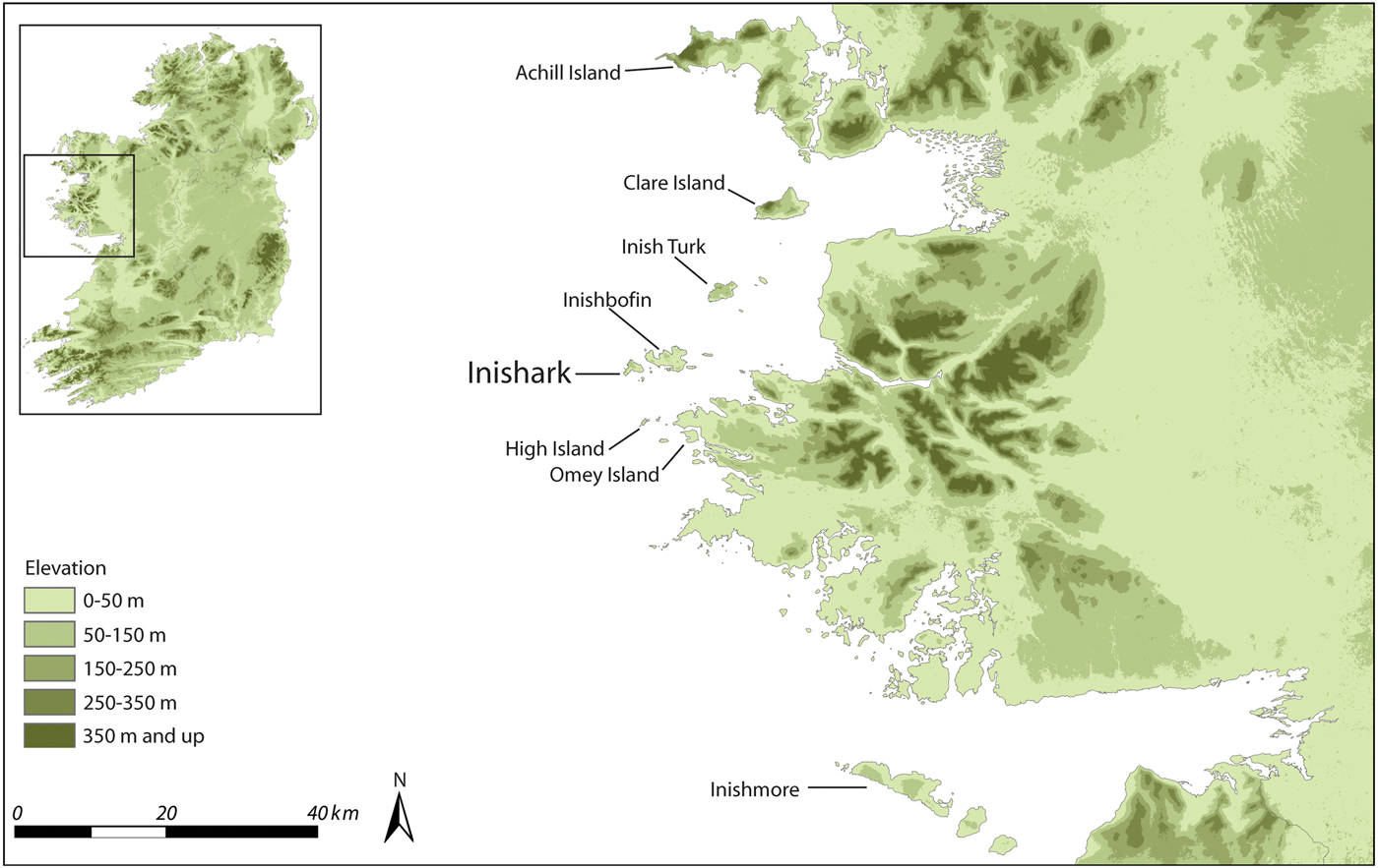
The maritime seascape of central-western Ireland, from Galway Bay to Clew Bay, includes small islands and a narrow ribbon of usable land along the coasts of County Galway and Mayo, bounded by the high mountains and boglands of Connemara to the east and Atlantic Ocean to the west (Figure 1). Varying in size, topography, and soil composition, the coastal islands, including Achill Island, Omey Island, Inishbofin, Inishturk, Inishark, Clare Island, and the Aran Islands, are distinct microenvironments with unique occupational histories. Some were inhabited from the Neolithic period to the present (e.g. Gosling et al., Reference Gosling, Manning and Waddell2007). The extent of human settlement on specific islands was probably linked to the availability of soils for growing crops and fodder for livestock, the availability and control of water, the feasibility of access to the mainland, and access to fish stocks in the surrounding waters (Gibbons & Higgins, Reference Gibbons and Higgins1993).
Western Irish seascapes with islands mentioned in the text.

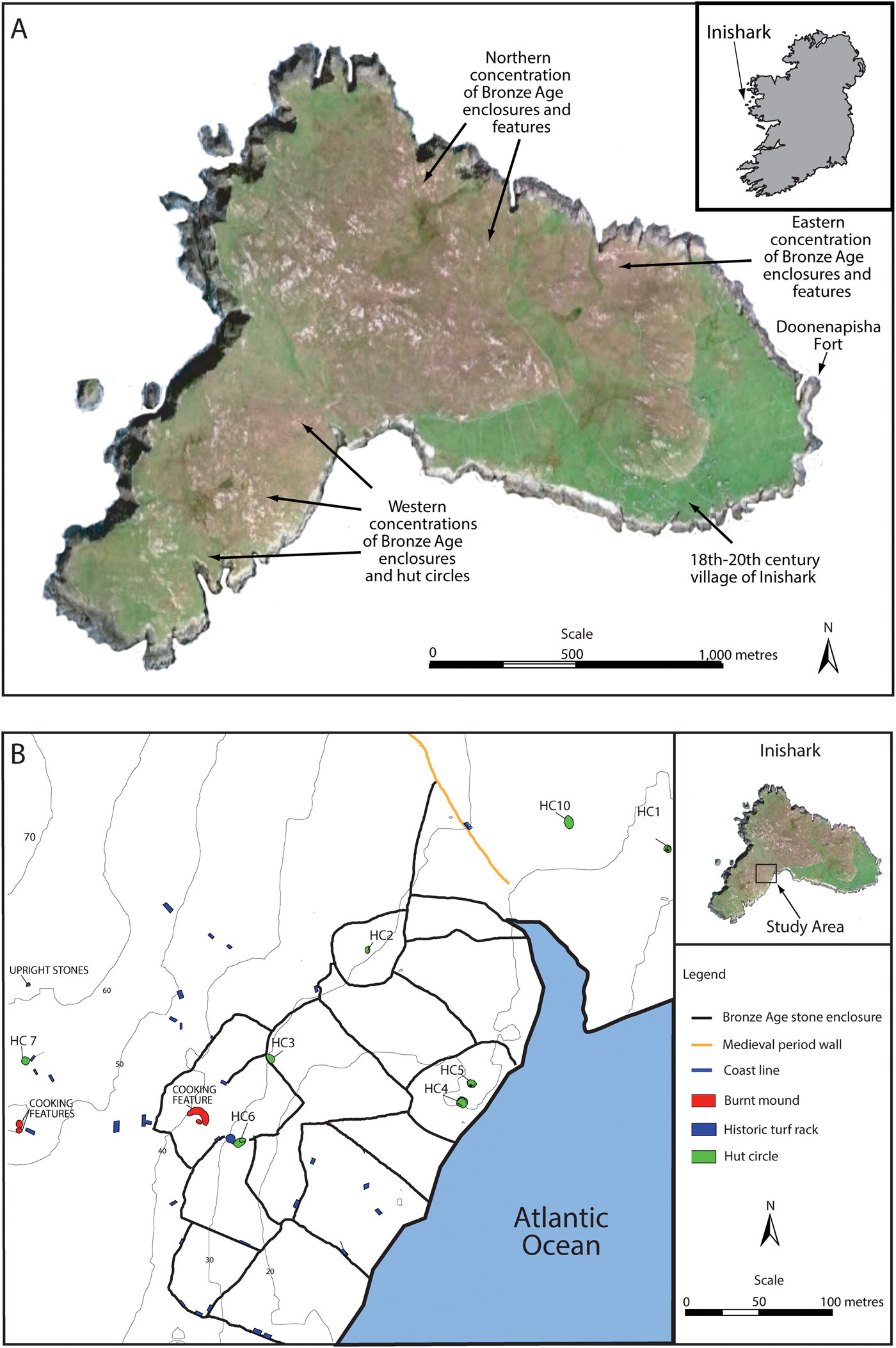
Located eight km from the mainland, Inishark is about 2.75 km long in an east–west direction, and 1.2 km wide from north to south (Figure 2A). The treeless island rises from the lower and more protected southern and eastern side of the island to cliffs at least 100–150 m high along the western and northern sides. The island poses significant environmental and topographical challenges: frequent exposure to high winds, unpredictable access to the island across open water, scarce fuel sources, variable soil quality, and extensive upland bogs and wetlands. The majority of nineteenth- and twentieth-century as well as medieval-period occupation was located on the south-eastern end of Inishark (Gibbons & Higgins, Reference Gibbons and Higgins1993; Kuijt et al., Reference Kuijt, Lash, Gibbons, Higgins, Goodale and Ó Néill2011; Goodale et al., Reference Goodale, Bassett, Bailey, Lash and Kuijt2018), which has a small pier and is more protected from the elements.
Inishark: (A) locations of Later Bronze Age remains across the island: (B) location of Later Bronze Age field systems, hut circles, and burnt mounds in the south-western area of the island.

The long-term use of Inishark has simultaneously preserved, exposed, and destroyed evidence of prehistoric occupations. With Neolithic deforestation, expansion of blanket bog continued into the Bronze Age and Iron Age in western Ireland (O'Connell Reference O'Connell1990a, Reference O'Connell and Doyle1990b; Molloy & O'Connell, Reference Molloy, O'Connell and Chambers1993). Blanket bogs covered and preserved the prehistoric landscape of Inishark. The removal of this uppermost layer of turf on the western end of the island during the eighteenth- to the twentieth-centuries exposed a series of large alignments that proved to be Bronze Age hut circles and field walls. Any Bronze Age occupation on the south-eastern end of the island has now been destroyed or covered by the historic village. Inishark was abandoned in 1960, and consequently the impact of modern agricultural machinery on the archaeological landscape has been limited. This pattern is strikingly different from the coastal mainland. Viewed as a whole, Inishark provides a unique opportunity to understand LBA island lifeways.
Archaeological Features in Irish LBA Landscapes
The nature of LBA occupation on Inishark can best be understood through a range of archaeological features that typify Irish LBA occupation, and to an extent Scotland, Wales, and England. The shared features of LBA occupations include stone-walled field systems, residential structures, burnt mounds, and fortifications. To understand the nature of the use of Inishark by LBA communities, we first need to characterize these features.
LBA field systems are areas enclosed by stone walls, presumably for controlling stock or agriculture. In the stony landscape of Ireland, the construction of walls serves to remove stones to allow easier ploughing, and to create boundaries. Stone walls represent an investment of labour designed to increase the productivity and security of both agricultural and pastoral subsistence economies. While pre-bog field systems have been identified in several locations in western Ireland, most of these field systems remain undated (Cooney, Reference Cooney and Barry2000; Jones, Reference Jones2016), though some researchers are starting to address this problem (e.g. Whitefield, Reference Whitefield2017). In particular, Gosling and Waddell (Reference Gosling, Waddell, Gosling, Manning and Waddell2007: 311) employ radiocarbon analysis to date some Clare Island walls to the first half of the first millennium bc (Gosling, Reference Gosling, Gosling, Manning and Waddell2007: 40). Similarly, Verrill and Tipping (Reference Verrill and Tipping2010) have used both spatial associations and 14C dates to link field systems and hut circles to the LBA at Belderg Bay, Co. Mayo.
LBA residential structures varied in size, shape, construction technique, and feature composition (Ó Néill, Reference Ó Néill2009a; Ginn, Reference Ginn2016: 97–104). Hut circles, also called roundhouses, were round or semi-circular structures that were the most common form of Bronze Age residence (Ginn, Reference Ginn2016: 97). Hut circles range in size from approximately 3 to 12 m in diameter (with a floor area measuring an average of 48 m2), and were likely to have been dwellings for nuclear families (Ginn, Reference Ginn2016). Hut circles probably had thatch or sod roofs above wattle and daub walls that in some cases were constructed on top of a low course of stones, although some houses had larger stone walls (e.g. Achill Island: Rathbone, Reference Rathbone2011).
Burnt mounds, or fulachtaí fia, are round or horseshoe-shaped piles of fire-cracked stones with a central trough (Waddell, Reference Waddell2010: 183; Hawkes, Reference Hawkes2013). These features formed as people transferred heated stones into water-filled open-air pits to boil the water (Ó Néill, Reference Ó Néill2005, Reference Ó Néill2009b; Hawkes, Reference Hawkes2013: 2). These are generally held to have served as cooking features (O'Kelly, Reference O'Kelly1954; Hawkes Reference Hawkes2013, Reference Hawkes2015), although other functions are possible (see Quinn & Moore, Reference Quinn, Moore, Stanley, Danaher and Eogan2009). Burnt mounds first appeared during the Early Neolithic, became widespread around 2800–2500 bc, and their use intensified through the Bronze Age before disappearing during the Iron Age (Hawkes, Reference Hawkes2013). These mounds range in size from 3 to 20 m in diameter, are found in areas with access to fresh water, such as upland wetlands (bogs), and are often located outside prime agricultural land (Hawkes, Reference Hawkes2013: 7). More than 7000 burnt mounds have been identified across Ireland (Waddell, Reference Waddell2010: 185; Hawkes, Reference Hawkes2013: 2), including fifty-three on Clare Island (Gosling, Reference Gosling, Coxon and O'Connell1994; Coxon, Reference Coxon and Graham2001).
The emergence of fortified settlements, particularly large hillforts, and the appearance of metal weapons (Molloy, Reference Molloy2017) were important developments in LBA economic and settlement systems (Cooney, Reference Cooney and Barry2000; Grogan, Reference Grogan2005; Cotter, Reference Cotter2012; O'Brien, Reference O'Brien2017). Smaller forts on promontories jutting out into the ocean are found along many areas of the western Irish coast. Large hillforts, such as Dún Aonghasa and Mooghaun, would have required significant labour to construct and are likely to have played a social role as a costly signal of the power of the local elite (O'Brien & O'Driscoll, Reference O'Brien and O'Driscoll2017). On smaller islands, promontory forts would have required significantly less labour to construct. Promontory forts and hillforts in western Ireland would have allowed people to control trade, signal authority, and serve as central places for ritual and economic activities (O'Brien & O'Driscoll, Reference O'Brien and O'Driscoll2017; O'Brien et al., Reference O'Brien, O'Driscoll, Hogan, Fernández-Götz and Roymans2018). Only limited research has focused on promontory forts, and consequently they are variably dated to the LBA/Iron Age and medieval periods (see Gosling, Reference Gosling, Gosling, Manning and Waddell2007: 42–43). Accurate dates for promontory forts have been difficult to obtain in the past (Cotter, Reference Cotter and Henderson2000; Casey, Reference Casey, Gosling, Manning and Waddell2007).
Previous research on the coast and islands of central-western Ireland has identified many of the hallmarks of LBA occupation. In addition to Inishark and Inishbofin, evidence of potential Bronze Age occupation includes field systems, hut circles, and burnt mounds on Achill Island (Rathbone, Reference Rathbone2011); field systems, hut circles, burnt mounds, and fortifications on Clare Island (Gosling et al., Reference Gosling, Manning and Waddell2007); hut circles and middens at False Bay (McCormick et al., Reference McCormick, Gibbons, McCormac and Moore1996); field systems, hut circles, and major fortifications on Inishmore (Cotter, Reference Cotter2012); field systems and burnt mounds on Inishturk (Gosling et al., Reference Gosling, Manning and Waddell2007); and a hut circle on Omey Island (O'Keefe, Reference O'Keefe1994). Few of these features have been dated to the Bronze Age with radiocarbon dates, with major exceptions for three hut circles on Achill (McDonald, Reference McDonald2016), four burnt mounds on Clare Island (Gosling & Waddell, Reference Gosling, Waddell, Gosling, Manning and Waddell2007), two middens at False Bay (McCormick et al., Reference McCormick, Gibbons, McCormac and Moore1996), a hut circle on Omey Island (O'Keefe, Reference O'Keefe1994), and many dates from Dún Aonghasa on Inishmore (Cotter, Reference Cotter2012).
If Inishark was occupied during the LBA, we would expect to see these features occurring together on the island. While the temporal span of each of these features can extend beyond the LBA (e.g. burnt mounds dating to the Neolithic or Iron Age, or promontory forts from the medieval period), they are not all present in other periods (e.g. no burnt mounds from the medieval period: Hawkes, Reference Hawkes2012). Here, we shall use radiocarbon dating to further demonstrate the occupation of Inishark and other western islands of Ireland during the LBA.
Multi-Scalar Approach to Inishark and the Western Islands of Ireland
Research on Inishark integrates data from three scales of analysis: the macro-scale with air photographs and satellite imagery, the meso-scale with mapping of wall systems, fieldwalking, and the use of geophysical survey, and micro-scale with archaeological test excavations and laboratory analyses. The macro-scale examination of landscapes allowed us to quickly assess the extent of exposed prehistoric landscapes and identify and map areas of possible field walls to target for survey.
We undertook fieldwalking on Inishark, using multiple transects in areas where air photographs and satellite imagery indicated the presence of features visible on the surface. Single transects across the rest of the island confirmed the absence of identifiable archaeological material on the surface. All archaeological features were recorded with a Trimble Geo XH handheld GPS linked to a ProXRT receiver and Hurricane antenna capable of sub-10 cm accuracy. Geophysical survey, using both a magnetometer (Bartington Grad601-2; 0.25 m sample interval and 1 m transect interval) and an electrical resistivity meter (Geoscan Research RM15; 1 m sample interval and 1 m transect interval), was conducted on a 100 × 40 m area to assess the relationship between surface and subsurface features. Geophysical survey covered an entire enclosed field system and portions of others, cross-cutting a few of the large field walls, and covering several visible hut circles.
Archaeological excavation was employed to understand the construction, use, and abandonment of several hut circles. In order to assess the function, chronology, and preservation condition of these sites and their associated field systems, we conducted test excavations between spatially associated hut circles and field systems. The sampled hut circles were identified during our fieldwalking survey and located in different field systems at the west end of Inishark. Test trenches of 3 × 0.5 m or 4 × 0.5 m were excavated to collect artefacts, gather datable material from intact deposits in secure contexts for subsequent radiocarbon analysis, and to assess the nature of the construction of the buildings. These excavations revealed intact deposits and datable charcoal in all hut circles. As with other excavated hut circles on Achill Island and Clare Island, the excavations did not produce large quantities of material culture (see Gosling, Reference Gosling, Gosling, Manning and Waddell2007; McDonald, Reference McDonald2016).
Results
The Later Bronze Age occupation on Inishark
Despite being in a remote location, our field research demonstrates that all of the material hallmarks of the Irish LBA are present on Inishark (Figure 2B). There are extensive, well-preserved field walls made up of large, upright, regularly spaced stones (Figure 3). The walls, which appear from the air as a series of circles, half circles, and rounded rectangles, enclose large areas found along the north-eastern and south-western shorelines. In the centre of many, but not all, of these enclosures are one or more semi-subterranean hut circles. There are no identifiable entrances, gates, or passages between the enclosures. Presumably smaller stones, no longer in situ, filled in parts of the original field walls. Today, more than 1500 m of walls, comprising at least thirteen separate enclosures, are preserved on the western end of Inishark. There are also extensive field systems of comparable design on the north and north-eastern areas of the island (see Figure 2A). Collectively, the field systems on Inishark are among the best-preserved and most extensive LBA field systems currently mapped in Ireland.
Photographs of south-western Inishark, showing (A) extensive stone enclosure walls, and (B and C) curving wall lines and use of large stones to make the wall system (photograph: I. Kuijt).

The shape and organization of these field system enclosures are suggestive of episodic settlement expansion. The field wall abutments appear to show that the circular and semi-circular fields along the shoreline were constructed first. Subsequently, additional fields were cleared and walls were constructed, each sharing a wall with previously cleared fields. The sequential development of the enclosure systems may have been due in part to increased population, agricultural intensification, or exploitation of forest resources that may have lasted longer on coastal islands than on the mainland (Coxon, Reference Coxon and Graham2001; Huang, Reference Huang2002).
The fieldwalking survey identified ten visible hut circles and noted several other features that may have been hut circles on the western end of Inishark. These circular or oval structures range from 2.8 to 8 m in diameter. The hut circles average 4.45 m across, which fits within the previously recorded size ranges for LBA roundhouses (see Ginn, Reference Ginn2016: 10). The western Inishark hut circles are variously positioned in the centre of field systems, against field walls, and on prominent locations at higher elevations (see Figure 2B).
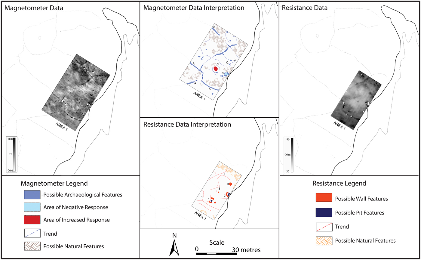
Geophysical survey of one area identified at least four additional circular anomalies in one field that were not visible on the surface (Figure 4). While these anomalies have not been excavated and, therefore, questions remain as to their function and period of construction, their size and location are consistent with LBA hut circles and stone enclosures.
Data and interpretation of magnetometer and resistance geophysical surveys of the area around hut circle 4 in south-western Inishark. Note the extensive wall systems (features A, 1) as well as subsurface anomalies (features C, 3, 4) that may be additional hut circles or features associated with hut circle 4 (feature B, 2).

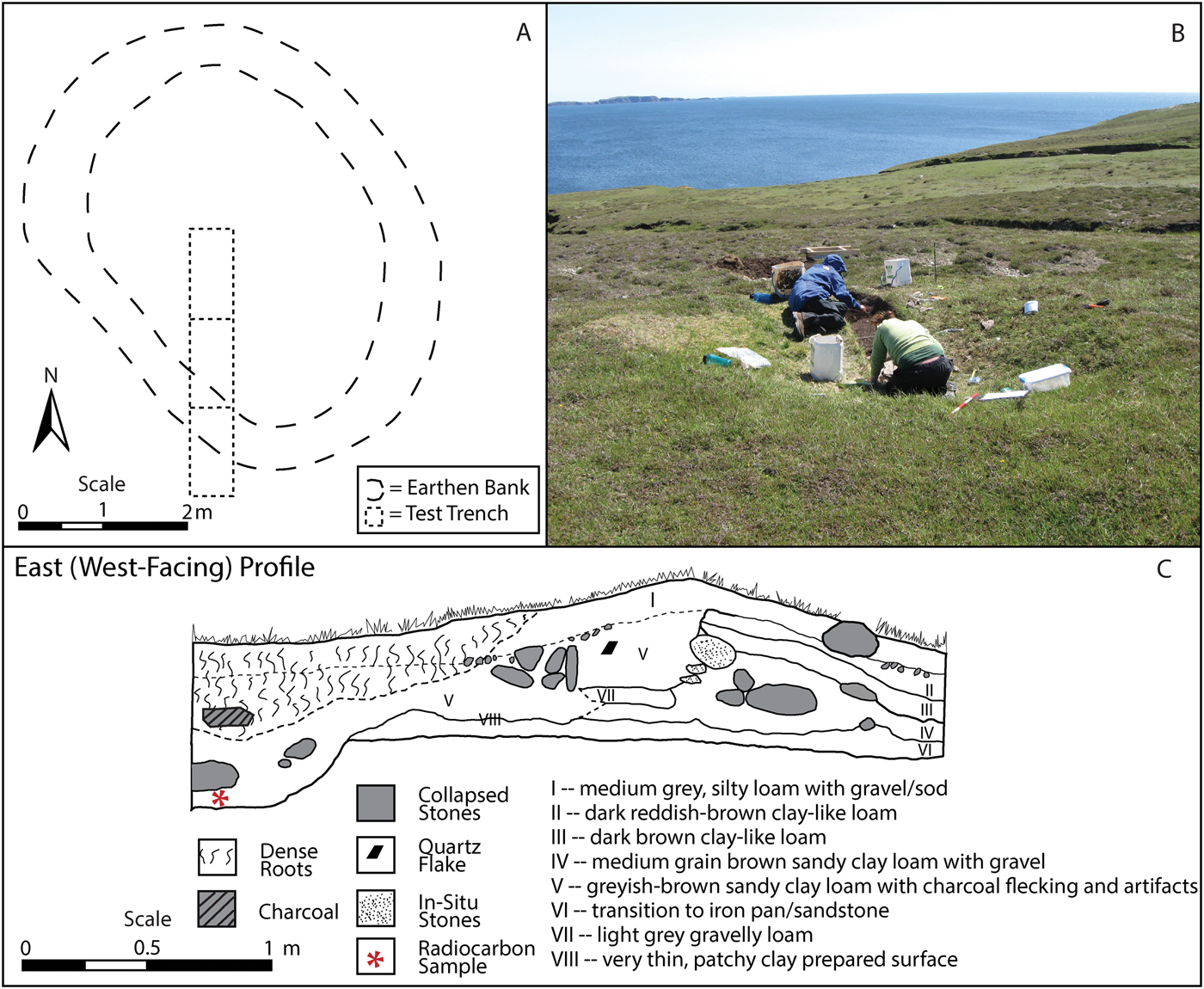
Test excavations were conducted at three hut circles. Hut circle 10 is an oval depression located along a low ridge, east of the large north–south wall (Figures 2 and 5). This hut circle was semi-subterranean, with a stone wall and distinct interior and exterior deposits. The exterior deposits recovered include a buried living surface covered with wall slump and collapse. Three round chipped schist artefacts were found at the top of the wall (Figure 6: nos. 4, 6, and 8). Although post-abandonment processes damaged most of the internal features of the hut circle, it was possible to identify two intact features: a pit located near the centre of the hut circle containing one rounded beach pebble (Figure 6, no. 5) and a grey clay prepared floor mottled with charcoal (see Figure 5C). A sample of charcoal recovered from the central pit produced a radiocarbon date of 1260–1110 cal bc (UCIAMS-76145; 2960 ± 20 bp).
Hut Circle 10, Inishark: (A) plan of hut circle, (B) view of hut circle showing placement near shoreline, and (C) east profile illustrating internal pit feature, external wall of hut circle, and extramural areas. There is an intact prepared grey clay surface (VIII) at the interface between stratum V and VI. A radiocarbon sample from the central pit within stratum V dates this structure to the LBA (UCIAMS-76145; 2960 ± 20 bp) (photograph: C. Quinn).

Artefacts recovered from excavations. Hut circle 10 (4, 6, 8: schist discs; 5: beach pebble; 9: worked schist). Hut circle 2 (3: saddle quern; 12: worked quartz; 1, 2, 11: worked schist). Hut circle 4 (10: schist disc; 7: beach pebble). Inishbofin (13: bronze spearhead) (illustrations 1–12: E. Carlson, photograph 13: I. Kuijt).

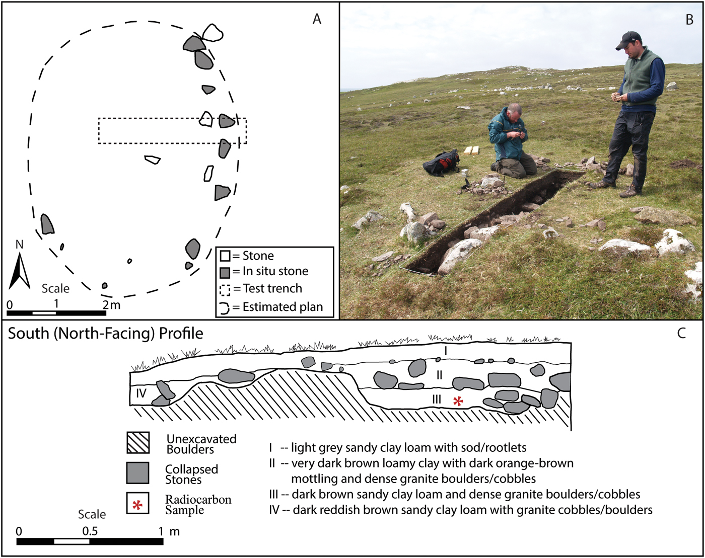
Hut circle 2 is an oval stone structure oriented almost directly north–south and centrally located within a sub-circular field system (see Figure 2B). The lower walls were constructed of large stones while the upper wall was built of smaller stones that collapsed on both the interior and exterior of the structure (Figure 7). Recovered from the collapsed fill was a large saddle quern fragment that had been incorporated into the construction of the wall (see Figure 6, no. 3). There were two strata within the structure, the deposits being disturbed by collapsed stones. At the base of the trench were several charcoal fragments on top of a flat stone, one of which produced a date of 1500–1420 cal bc (UCIAMS-76145; 3185 ± 20 bp).
Hut Circle 2, Inishark: (A) plan of hut circle, (B) excavation of external wall and interior of hut circle, and (C) south profile through external wall of hut circle. A radiocarbon sample from stratum III dates this structure to the LBA (UCIAMS-76145; 3185 ± 20 bp) (photograph: C. Quinn).

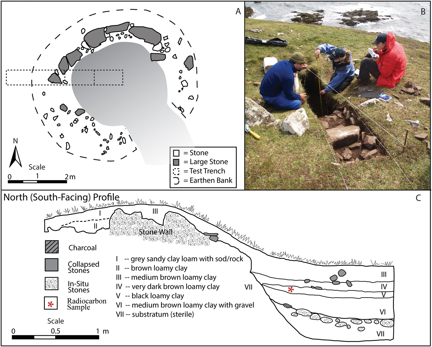
Hut circle 4 is defined by a semi-subterranean circular stone wall with an interior depression and an exterior earthen bank around the stones (Figure 8). The hut circle is located within a D-shaped field system (see Figure 2B). It is possible that part of the field system has been destroyed by coastal erosion. There are three layers of cultural deposits within the structure (see Figure 8). One chipped schist disc was recovered from the top of the wall (see Figure 6, no. 10) and is similar to those found in hut circle 10 (see Figure 6: nos. 4, 6, and 8). An unworked beach pebble brought into the structure, like the pebble in hut circle 10, was found in stratum IV, i.e. the earliest occupation level (see Figure 6, no. 7 and Figure 9C). A sample of charcoal taken from the second occupation level, stratum V, produced a date of cal ad 1250–1290 (UCIAMS-76146; 735 ± 20 bp), i.e. the medieval period, a period of intense human activity on Inishark (Kuijt et al., Reference Kuijt, Lash, Gibbons, Higgins, Goodale and Ó Néill2011; Goodale et al., Reference Goodale, Bassett, Bailey, Lash and Kuijt2018). The earliest occupation phase of hut circle 4 has not been dated, because our limited resources did not allow us to run additional samples from lower stratigraphic levels; however, similarities in size, shape, and construction technique compared to radiocarbon-dated structures, as well as the presence of similar artefacts, suggest that this hut circle was initially constructed and occupied in the LBA. There are other examples of medieval reuse of Bronze Age sites, such as at Achill Island, where an oval building at Cromlech Tumulus with a radiocarbon date of 1409–1229 bc was overlain by late medieval huts (McDonald, Reference McDonald2016: 23).
Hut Circle 4, Inishark: (A) plan illustrating large stones as part of the external wall, (B) excavation showing external wall and position of hut circle next to the cliff edge, and (C) north profile of hut circle showing external wall and complex internal stratigraphy. A radiocarbon sample from stratum V (UCIAMS-76146; 735 ± 20 bp) suggests V and IV are medieval. Stratum VI represents the initial occupation, potentially from the LBA (photograph: C. Quinn).

Doonenapisha Fort, Inishark, B = bank and D = ditch (photograph: I. Kuijt).

Three burnt mounds, ranging from 5 to 8 m in diameter, have been identified on Inishark (see Figure 2). Two are in an upland wetland area near the main cluster of field enclosures and the other is in a wetland associated with field systems on the northern side of the island. Burnt mounds are normally located near wetlands and water sources (see Ó Néill, Reference Ó Néill2005). These features were not excavated, and so questions remain about their date and possible functions.
There are promontory forts on Inishark and Inishbofin. Doonenapisha, located on the south-eastern edge of Inishark, is oriented roughly north–south and was fortified by a ditch and earthen bank (Figure 9). Coastal erosion has separated the promontory from the rest of the island. Doonenapisha has not been radiocarbon dated. The promontory fort of Doongraina, located at the south-western end of Inishbofin, is similar to Doonenapisha as it juts out into the sea and has been cut off from the rest of the island by erosion. Erosion on the western side of Doongraina has exposed 30–50 cm of cultural deposits made up of fire-cracked stones, ash deposits, fish and bird bones, and charcoal. Samples of charcoal taken from an eroding cooking feature at the base of the deposits date Doongraina to the LBA (UCIAMS-76148; 2710 ± 20 bp). Excavations in 2013 of an eighteenth/nineteenth-century stone building on eastern Inishbofin yielded a bronze spearhead next to an internal wall (see Figure 6, no. 13). It is possible that the spearhead was accidentally brought into the house as part of turf used for cooking fuel. This find is important for two reasons: it is evidence of weaponry associated with LBA communities on these coastal islands and it attests participation in long-distance exchange systems, as copper and tin are not locally available.
There is clear evidence of the occupation of Inishark during the LBA, especially in the western, northern, and south-eastern parts of the island (although any south-eastern occupation is likely to have been disturbed or covered by later medieval and historic occupations). It is clear that Inishark was occupied throughout the LBA (at least between 1500 and 1110 bc), although there may have been population oscillations within this period.
Situating Inishark in its regional context
A more holistic view of Bronze Age lifeways emerges when Inishark is set in the context of the western Irish seascape. The new dates from Inishark and Inishbofin contribute to the growing corpus of radiocarbon dates from Bronze Age archaeological features in this region, including from Dún Aonghasa on Inishmore (Cotter, Reference Cotter2012; Warner, Reference Warner and Cotter2012), Achill Island (Rathbone, Reference Rathbone2011), Omey Island (O'Keefe, Reference O'Keefe1994), Clare Island (Gosling et al., Reference Gosling, Manning and Waddell2007), and from a shell midden on the mainland coast at False Bay (McCormick et al., Reference McCormick, Gibbons, McCormac and Moore1996) (Figure 10). The current dates demonstrate that there was a long, but variable, use of coastal islands during the Bronze Age. There is significant inter-island variability in the nature, intensity, and duration of occupation during the LBA, perhaps most noticeable in variation in the frequency of burnt mounds on Inishark (n = 3) and Clare Island (n = 53).
Later Bronze Age radiocarbon dates from the central-western Irish coast and islands. Calibrated using OxCal 4.2 IntCal13 (Bronk Ramsey, Reference Bronk Ramsey2009; Reimer et al., Reference Reimer, Bard, Bayliss, Blackwell, Bronk Ramsey and Grootes2013).

The most intensively studied LBA fortified regional centre along the Irish west coast is Dún Aonghasa, located on Inishmore (Cotter, Reference Cotter2012). Dún Aonghasa is the only hillfort on the west coast of Ireland and the only site directly associated with Atlantic maritime trade corridors (Waddell, Reference Waddell2010: 231–32; O'Brien & O'Driscoll, Reference O'Brien and O'Driscoll2017: 4). The site included three walled fortifications containing domestic structures initially built in the LBA (Cotter, Reference Cotter2012: 232–49). Excavations have revealed that the Dún Aonghasa LBA community participated in long-distance Atlantic maritime exchange networks (Cotter, Reference Cotter2012: 267–69). Beads made from Baltic amber and bronze objects, such as rings, bracelets, chisels, tweezers, pins, and fragments of axes and knives, were recovered in LBA contexts (Cotter, Reference Cotter2012: 48–54). These exotic materials were commonly traded through Atlantic maritime networks during the LBA (see Henderson, Reference Henderson2007: 57–98). The large collection of clay crucibles and moulds for casting bronze objects, plus metalworking debris, at Dún Aonghasa show that the community was engaged in on-site metalworking activities (Cotter, Reference Cotter2012: 28–46).
There is evidence of shared material culture between Inishark and Inishbofin, and Dún Aonghasa. There are parallels for objects found on Inishark at Dún Aonghasa, including grinding stones (e.g. Cotter, Reference Cotter2012: fig. 8.54, no. 1361) similar to the saddle quern from hut circle 2 (see Figure 6, no. 3), rubbing stones (e.g. Cotter, Reference Cotter2012: fig. 8.45, no. 2127) similar to the beach pebbles found in hut circles 10 and 4 (see Figure 6, nos. 5 and 7), and schist discs (e.g. Cotter, Reference Cotter2012: fig. 8.57, nos. 607, 1161, 840). The schist discs are particularly intriguing since previous mineralogical and geochemical sourcing of schists from the western central coast of Ireland has been able to detect inter-island movement of schist (see Goodale et al., Reference Goodale, Bassett, Bailey, Lash and Kuijt2018). Future work sourcing schists could help archaeologists reconstruct local exchange networks during the LBA. The spearhead found on Inishbofin is similar to that found in the Dowris hoard, and a mould for the same type has been found at Dún Aonghasa (Cotter, Reference Cotter2012: fig. 13.13).
At the household level, there are similar activities represented on small islands and at the large regional centre of Dún Aonghasa. The scale of metalworking suggests that there were qualitative differences between the community at Dún Aonghasa and the smaller-scale communities that lived on Inishark, Inishbofin, and the other small islands and coastal communities to the north.
Discussion
The archaeological evidence of the Inishark LBA occupation provides a fresh perspective on small island communities, and the broader socioeconomic organization of the Bronze Age Atlantic coast. Data from Inishark add to the growing research into the LBA use of purportedly marginal landscapes (e.g. Cooney, Reference Cooney and Barry2000; Warner, Reference Warner and Cotter2012; Rathbone, Reference Rathbone2013; Ginn, Reference Ginn2016: 214–15). Palaeoenvironmental studies have linked landscape modification to several periods of settlement reorganization, with fluctuations between more nucleated to more dispersed settlement expansion into previously unoccupied landscapes such as upland and wetland environments (Molloy & O'Connell, Reference Molloy, O'Connell and Chambers1993; Molloy, Reference Molloy and Grogan2005; Plunkett, Reference Plunkett2009). With data from Inishark and Inishbofin, it is now clear that small coastal islands were extensively occupied during the LBA.
The LBA occupation of small island landscapes suggests that people weighted the socioeconomic benefits of living on islands over the substantial challenges, and risks, of living on these islands. Regional settlement distribution can reveal the interconnectivity between communities, the physical and cultural landscape, and how people existed within a political and economic network to create a broader social geography (Kosiba & Bauer, Reference Kosiba and Bauer2013; Quinn & Ciugudean, Reference Quinn and Ciugudean2018). Given that LBA people only had access to small water craft (see Wright et al., Reference Wright, Hedges, Bayliss and van de Noort2001), islanders of this era faced regular challenges while living on, and travelling between, small islands and the mainland. Unpredictable and dangerous seas and storms provided significant challenges to the sustainability of particular locales and the ability of islanders to connect to communities in other areas. Social conflict, particularly raiding, also appears to have been a significant factor in LBA island life (see O'Brien & O'Driscoll, Reference O'Brien and O'Driscoll2017). Nevertheless, people within island communities accepted these risks and settled on small islands, investing in agro-pastoral productivity through landscape modification and built fortifications as signals and for protection. The assumed social and environmental risks of island living were probably balanced by the strategic, economic position of the small islands on an emerging, significant maritime exchange route.
The nature of interaction between members of small island communities, such as Inishark, and communities at large regional centres was likely to have been multi-faceted and dynamic. The hillfort of Dún Aonghasa has been interpreted as a potential higher-status site, possibly at the top of a hierarchy of settlement (Waddell, Reference Waddell2010: 231). It is strategically positioned to dominate seagoing traffic and serve as an economic hub for maritime exchange along the west coast (Waddell, Reference Waddell2010: 231; O'Driscoll, Reference O'Driscoll2017), as a symbolic reference point for travellers (Driver, Reference Driver2013: 59), and as a signal of the power and strength of the Dún Aonghasa elites and associated community (O'Driscoll, Reference O'Driscoll2017). Livingood (Reference Livingood, White and Surface-Evans2012) argues that the size of traditional chiefly polities is limited by the need to oversee, or come to the aid of, all communities within their sphere of influence. In ethnographic contexts, leaders must be able to reach peripheral settlements from the political centre and return within a day. Livingood (Reference Livingood, White and Surface-Evans2012) argues that the radius of chiefly polities, therefore, is normally less than five hours travel time from the political centre (approximately 20 km). Inishark is over 60 km from Dún Aonghasa. It is however possible that Dún Aonghasa served as a regional hub to which Inishark community members travelled for social, economic, and ideological purposes. Episodic, rather than daily, interaction would have allowed the Inishark community to remain integrated within a broader cultural seascape and at the same time avoid negative aspects of polity membership, such as having to provide tribute to elite communities at Dún Aonghasa. The gaps between the radiocarbon dates on Inishark and those from other small coastal islands is most likely to be a by-product of minimal sampling. It is possible, however, that there is a diachronic aspect to the relationship between small communities and regional centres. A process of fission and fusion, where communities came together at regional centres and/or dispersed to more peripheral landscapes, has been documented in other parts of Bronze Age Europe (see Duffy et al., Reference Duffy, Parkinson, Gyucha, Yerkes and Birch2013).
Being on the sea, Inishark and other western Irish coastal communities were well positioned to access wider Atlantic maritime exchange networks. The importance of these networks to the elites in hillforts has been well documented (see Ginn, Reference Ginn2016: 210–11). In reconstructing Bronze Age societies, Ginn (Reference Ginn2016: 211) argues that hillforts housed small elite communities that controlled at least some of the metal trade and served as administrative and ideological centres for the wider landscape. The elites at large fortified sites across Ireland and the Atlantic façade were connected through international trade and had many shared characteristics, including material culture and the ability to exert some local political authority within their ‘maritory’ (Needham, Reference Needham and Clark2009). It is likely, however, that areas without hillforts were organized differently. Ginn (Reference Ginn2016: 210) argues that most of the Bronze Age population was independent, particularly in terms of domestic activities such as food production, even when located close to hillforts. Members of the Inishark community, situated far enough away from Dún Aonghasa to avoid daily interaction, would have had significant autonomy, allowing them to tap into maritime exchange networks normally associated by archaeologists with elites. It is possible that these small islands, like hillforts, may have been important visible and symbolic reference points for travellers, and acted as places for rest and embarkation for maritime traders (see Driver, Reference Driver2013: 59; O'Driscoll, Reference O'Driscoll2017). Despite the importance of hillforts in the organization of Bronze Age settlement systems, the communities on the small islands off the coast of Connemara and Clew Bay were probably shaped by inter-island and island-mainland coastal interactions on a local scale and able to access international trade routes themselves rather than through any authority imposed by the elite at regional centres.
Conclusion
This study presents evidence for the LBA occupation of Inishark on the central-western coast of Ireland. Conceptualizing the west coast of Ireland as an integrated seascape, we outline how the development of long-distance exchange networks throughout the Bronze Age transformed challenging coastal seascapes into an important corridor of human interaction and movement of goods and people. The archaeological evidence presented here contributes to a growing understanding of the antiquity and far-reaching extent of these seascapes.
Future research needs to expand on this foundation in several ways. Larger-scale excavations of houses and extramural areas may help recover more artefacts so as to fully reconstruct the economic activity along these seascapes. The excavation and dating of non-residential features on Inishark, such as burnt mounds, fortifications, and field enclosures, would provide further details of LBA island lifeways. An expanded radiocarbon dating programme from smaller islands would help clarify whether these islands were continuously occupied throughout the LBA or only during brief periods. These small island and coastal landscapes remain significantly under-sampled, especially when compared with the large quantity of dates from regional centres such as Dún Aonghasa. Studies of provenance, such as that of the schist objects found across the islands, may provide important insights into the local interactions that would complement studies of long-distance exchange.
The new perspectives of small island occupation presented here complement, and add nuance to, broader narratives of Bronze Age societies in Ireland that have traditionally focused on large fortified settlements, metal procurement, and long-distance trade and exchange across Europe. The communities living on small islands on the western Irish coast were on the periphery of both the European continent and the elite spheres of influence at hillforts in Ireland, but they were connected to the Atlantic maritime exchange routes that transformed local seascapes into highly productive corridors of interaction that affected the development of social complexity in Bronze Age societies.
Acknowledgements
This field research was made possible by the John Tynan family. Additional funding was provided by the Institute for Scholarship in the Liberal Arts and the Office of Sponsored Research at the University of Notre Dame, the University of Michigan Museum of Anthropological Archaeology, and the Dean of Faculty at Hamilton College. This article has developed through the constructive comments, discussions, and fieldwork of Michael Gibbons, Gabriel Cooney, Franc Myles, Meredith Chesson, Alissa Nauman, John O'Shea, Joyce Marcus, Meagan Conway, Ryan Lash, Lacey Carpenter, and six anonymous reviewers. We would like to thank all members of the Cultural Landscapes of the Irish Coast Project, especially the students from the University of Notre Dame and Hamilton College who assisted with fieldwork. We thank Eric Carlson for the artefact illustrations. Finally, to all the communities of Inishark, Inishbofin, Letterfrack, and Clifden whose support made documenting island life possible, we are deeply thankful for letting us learn about, and share in, your history and heritage. This field research was carried out under National Museum of Ireland licences 10E0401 and 09R0110.