Location = township. Occasionally used of a residential area for any group which was not white. ‘Location’ is now avoided by many, being replaced by ‘township’.Footnote 1
The historiography of Soweto
What might be termed the pre-history of Soweto – the history of the inception of the congeries of African townships south-west of Johannesburg which were eventually bracketed together under the acronym ‘Soweto’ in 1963 – is not a subject to which historians have given much attention. To them, the dominant theme in the history of that township and its predecessors has been the dramatic resistance offered by residents to white rule, whether by James Mpanza's squatter movement in the 1940s, the Asinamali Party's rent boycotters from 1954 to 1958, those who enthusiastically accepted the Freedom Charter at Kliptown in 1955 or school pupils who raised the banner of revolt from 1976. Characteristic of this emphasis is Walter Sisulu's foreword to Soweto: A History, a book which, he claimed,
bears testimony to the bold resilience of the people of this country to . . . survive the extremities of repression and the violence of apartheid, but also to create a vibrant, caring, communal environment that reinforced humanity in conditions of pronounced inhumanity. The people of Soweto refused to let their spirit die, and it is that spirit which contributed to the demise of apartheid . . . [a] spirit [which] is also captured in the pages of this book.Footnote 2
Accordingly, Soweto: A History devotes but one brief paragraph to the beginnings of African settlement on the site which became Soweto,Footnote 3 while popular histories mention it even more fleetingly, usually with errors.Footnote 4 Glumly, the only author to have begun to do justice to the complex origin of Soweto's location, the geographer Keith Beavon, noted in 2004, ‘Unfortunately, in relative terms very little primary research on Soweto has been conducted . . . Given the resultant paucity of secondary literature, more questions have been posed than have been answered.’Footnote 5
This article will also pose questions about Soweto, in particular why it is where it is and how its components came to be there in the first place. However, it will seek to answer these too, not on the basis of superficial, existing accounts, but by drawing on primary sources, especially the published and unpublished records of the Johannesburg Municipality and the Rand Plague Committee, the verbatim evidence before the hearings into the Johannesburg Insanitary Area Improvement Scheme Commission's Report and, above all, contemporary newspapers whose columns of daunting small print carry in great and illuminating detail speeches at meetings, interviews and letters by contemporary actors.
Nor, as what follows will reveal, do these answers lack their own drama, high-profile figures or even fire and ash. Moreover, as an outbreak of pneumonic/bubonic plague played a not inconsiderable part, this inquiry also allows us to revisit Maynard Swanson's argument about the influence of a ‘sanitation syndrome’ in official policy-making in early industrial South AfricaFootnote 6 and, in the light of the findings in this rich case-study, to analyse their relationship more deeply.
The wider context of Johannesburg in 1901, newly come under civilian rule after nine months of military government by the British army during the South African War, is where this investigation into the pre-history of Soweto must begin.
Johannesburg and post-war Reconstruction
The ‘city of gold’ lay at the centre of the Reconstruction project initiated by the new governor of the Transvaal, Viscount Alfred Milner. This sought to turn the former Boer republic into a modern, efficient and go-ahead state under British direction, able to entice immigrants from Britain and well geared to meeting the needs of the biggest gold producer in the world. If Johannesburg, at the heart of this production, could be swiftly overhauled and transformed into a model, English-style city administratively, fiscally, infrastructurally and sanitarily – a Birmingham on the Highveld – then Reconstruction would be off to an excellent start which could be emulated elsewhere in the newly conquered colony. It was Milner's aim, writes the biographer of his appointee as town clerk of Johannesburg, ‘that Johannesburg would lead the way to a British Transvaal governed on modern lines . . . and even inform the ideal of a larger South Africa’.Footnote 7
To this end, Milner appointed a cadre of hand-picked officials to pursue his vision with gusto, including not only the bright young Oxford men who made up his so-called ‘Kindergarten’, but also, for Johannesburg specifically, several well-experienced professionals from England, in particular the town's medical officer of health, Dr Charles Porter, and the town engineer, Donald Leitch. As its acting mayor, Milner chose a civil engineer still in uniform, Major W.A.J. O'Meara, who had already been filling an executive mayor's role since 1900, when the army had taken the city.
As an engineer, O'Meara was appalled by the disordered state of the slumyards he found north-west of the city's Market Square.Footnote 8 His fellow engineer, Leitch, did not think ‘anything parallel could be found in a civilised town’.Footnote 9 To add to this, his repugnance was intensified early in 1901 when the dreaded bubonic plague pandemic radiating from China since 1894 reached Cape Town and Port Elizabeth, and seemed to be poised to move inland, making him see (and smell) these squalid slums with a sanitarian's eye (and nose) too. Two doctors’ reports which he commissioned condemned the so-called ‘Coolie Location’Footnote 10 at the heart of the slums as ‘insanitary in no unqualified terms’.Footnote 11 ‘I cannot too strongly impress on you the danger [to the rest of Johannesburg] of such a place’, wrote one,Footnote 12 while the other went even further, recommending to O'Meara ‘that he should burn the whole place down’.Footnote 13
Now perceiving Coolie Location (Figure 1) and its neighbouring areas too as ‘a hot-bed for dissemination’ of plague,Footnote 14 O'Meara referred the issue to the town council's new Public Health Committee where anti-Indian sentiment on sanitary, cultural, racial and economic grounds was as strong as in the rest of the white community. It quickly agreed that Coolie Location posed a ‘great risk to the health of the town’ and urged the ‘taking in hand [of] the removal of the locations with the least possible delay’.Footnote 15 However, touched by Milner's grand vision, it went further, enthusiastically broadening the scope of its brief beyond how to get rid of individual slum spots to discussing a full-scale remodelling of the whole district, using that favoured instrument of late Victorian social and sanitary engineers, a comprehensive improvement scheme which drew heavily on the ideas on slum clearance embodied in late nineteenth-century British housing legislation. Such a scheme, it intended, would be an effective tool for re-ordering the racial, social and sanitary geography of a key part of Johannesburg, which it now damningly labelled ‘the insanitary area’. At a stroke, this would not only open up a district close to the city centre for municipal and business development, but would also better safeguard the health, racial identity and commercial activity of whites, all of which were perceived to be at risk in a racially mixed district. As the Public Health Committee saw it, these ‘dangers’ to whites were closely intertwined: the Indian trader and hawker had an advantage over whites because ‘his lower standard, in so far as cleanliness and the ordinary requirements of life are concerned’ allowed him to undercut his pale-skinned competitors,Footnote 16 while ‘To allow Asiatics to live cheek by jowl . . . with the poor whites, could not be otherwise than harmful for both races’ in terms of both their health and their morals.Footnote 17
Coolie Location and its neighbouring areas close to the centre of Johannesburg. With acknowledgement to K.S. Beavon, Johannesburg: The Making and Shaping of the City (Pretoria and Leiden, 2004).

Taking a leaf out of O'Meara's own Notes on the Proposed Reconstruction of the Johannesburg Municipality,Footnote 18 early in 1902 the Public Health Committee tabled its full-scale Insanitary Area Improvement Scheme before the town council, along with a draft Insanitary Area Expropriation Ordinance to implement it. But these elicited such opposition from property-owners in the area that – despite a damning report on the area's insanitary state by Dr Porter, the new medical officer of healthFootnote 19 – Milner felt constrained to appoint a commission to investigate the basis of the scheme's recommendations and the validity of its proposed plan of action. Before its five members, supporters and opponents locked horns with ardour. While the objectors briefed a brace of top advocates to interrogate proponents of the scheme, the Johannesburg Town Council underlined that sanitation was to be its determining trope by calling six doctors to pathologize the Insanitary Area and its inhabitants, especially those who were not white-skinned. Leading them was the formidable Dr Porter – ‘no more diligent a recruit’ to Milner's vision was there, observes a recent author.Footnote 20 Nor did Porter disappoint, not sparing his epithets in portraying Coolie Location, in particular, as ‘slop-sodden and filth-bestrewn . . . as crowded as a rabbit warren . . . [and] the very greatest and most terrible source of possible danger . . . to the town . . . I shudder to think what would occur if plague or cholera broke out in that place.’Footnote 21 ‘There is no doubt whatever’, he added with a flourish, ‘that I should take it upon myself to advise the Council to authorise me, in the presence of plague or cholera, to demolish these buildings, whether we had any powers to do it or not.’Footnote 22 A contemporary in the Indian community commented perceptively that, to Porter, ‘anything that fails to come up to the standard observed in London, and is untidy or uncouth, is quite insanitary’.Footnote 23
In even more dramatic style, a second medical witness declared that, given such conditions, plague could only be avoided if ‘the place . . . [were] wired in, and burned with its inhabitants’,Footnote 24 while a third added, ‘[Y]ou cannot make that place a fit place to live in unless you pull the houses down and lay out the area in a proper way’,Footnote 25 an opinion echoed by Leitch, the town's engineer, who provided the commissioners with a map in which every one of Coolie Location's six blocks bore a double circle indicating ‘Position of Buildings condemned as insanitary and past repairs.’Footnote 26
Despite the efforts of opposing counsels to show that the town council's witnesses had focused only on unrepresentative parts of the area, the weight that the well-orchestrated evidence of the medical and engineering experts carried suggested that the writing was on the wall for Coolie Location, and probably the rest of the Insanitary Area too. It came as little surprise when the commission (which itself included one doctor) concluded that all of the Insanitary Area's inhabitants should be removed to racially distinct zones and the Area itself cleared of all structures and turned into a site for municipal, railway and tramway facilities and businesses. An ordinance authorizing the expropriations necessary to accomplish this was quickly passed, but when the town council sought to make a start with the project by selecting land west of Vrededorp to resettle the Area's evicted Indian and African residents, what Porter angrily called ‘insurmountable difficulties and paralyzing obstacles’Footnote 27 arose from outside of these, the two most directly affected parties.
First, Milner's government in Pretoria indicated that it had reservations about approving the removal of Indians to a spot far from Johannesburg's centre of commercial activity lest the government of India object.Footnote 28 This was a mild snag, however, compared to the reaction of white working-class residents in suburbs adjoining the proposed site, who rose up in a fierce racist protest, in effect declaring ‘nimby’ (‘not in my back yard’). In a petition to the town council, 1,300 residents of Fordsburg, Mayfair and Brixton objected strenuously to having the town's Africans and Indians as neighbours,Footnote 29 a rejection in which they persisted volubly even when the resettlement plans were modified to include erecting ‘an unclimbable fence’ between the proposed Indian location and Brixton and staggering the removal of Africans to the new site. A second mass meeting of hostile whites in Brixton produced ‘a very drastic resolution’,Footnote 30 something which must have concentrated the minds of existing town councillors intending to stand in the first municipal elections later in the year. Uneasily, one of them warned his fellow councillors, ‘Unless they did their best to provide a location somewhere else which would obviate the danger of creating another insanitary area, the dwellers in the western suburbs would rightly say that the Council was indifferent to the welfare of the western part of the town.’Footnote 31
The search for alternative sites further away from white suburbs – and thus less likely to evoke whites’ opposition – therefore intensified. ‘The further they removed the black men from the whites the better’, insisted another councillor, before explaining reassuringly that a railway link from there would certainly ensure that the city's supply of African labour was not disrupted.Footnote 32 Land south of the Reef at Concordia or to the west at Diepkloof Farm was identified as perhaps suitable and, consequently, both sites were flagged for further investigation. Pending this, starting phase one of the Insanitary Area Improvement Scheme was put on hold, to the fury of Porter. In no uncertain terms, he publicly warned the mayor against ‘the possibility of any further delay in doing away with this place [i.e. Coolie Location]’ because of the risk of a runaway epidemic breaking out there. The immediate removal of its population was essential, he averred, ‘and although such action may not be without grounds of objection by white residents in the vicinity, such objection . . . is entirely outweighed by the gain to the town at large by the removal of the present exceedingly dangerous location’.Footnote 33
Next day, he bulldozed the Public Health Committee into ignoring these objections and instead had them order 300 tents to accommodate Coolie Location's residents who would willy-nilly be moved, he had determined, to the chosen site adjoining Brixton. Supremely certain that he did know best, he unhesitatingly stated that he wished to make people live according to his rules of health, and replied, when asked if he would do so by force, ‘Yes, if necessary.’Footnote 34 Here was a new breed of doctor talking, a medical technocrat fully in the mould of the activist medical officer of health of Victorian Britain, whose confidence in bacteriology's ability to identify the causative pathogens of several high-profile diseases knew few bounds thanks to the germ revolution of the late nineteenth century. Such professional experts would have a significant say in the making of policy in South Africa in the coming century.
Plague, Pakes and Coolie Location
If truth be told, Porter's insistence on immediate action was not all the product of his ‘I-know-best’ conviction. On this occasion, it was fuelled too by his concern at what appeared to be a serious disease outbreak occurring in Coolie Location. Since the beginning of March 1904, the number of deaths there had been rising steadily. All were attributed to pneumonia, despite the insistence by a prominent member of the Indian community, the young lawyer, Mohandas K. Gandhi, that the cause of death was in fact plague.Footnote 35
But by the middle of March, Gandhi's identification was looking ominously accurate as 14 similar cases were reported on one day, all showing symptoms of the ‘black plague’. In one compound, a local doctor found eight very ill men ‘lying like so many beasts, all half-dying except one, who was dead’.Footnote 36 Gandhi immediately alerted the district surgeon to this dire situation and, within 24 hours of what he called this ‘ocular demonstration of the ghastly tragedy’,Footnote 37 an emergency hospital had been set up on the edge of the Location, houses where cases had been discovered had been thoroughly disinfected and the Government Bacteriological Laboratory had speedily come up with a diagnosis of the cause of death – pneumonic plague.
Pneumonic plague is an airborne version of bubonic plague and is caused by the same pathogenic bacillus, Yersinia pestis. It usually originates from a case of bubonic plague in which the lungs of a victim have become grossly infected, who then spreads the bacillus to others nearby by coughing. Thereafter, transmission from person to person is airborne and thus facilitated by crowded living conditions. Its symptoms closely resemble those of acute pneumonia rather than plague, and its case mortality rate is far higher than that of bubonic plague.Footnote 38 Certainly, the first rush of cases in Coolie Location fits into this mould very well: 57 of them (or 88 per cent) displayed only broncho-pneumonic symptoms and had occurred in a handful of densely packed, Indian-occupied homes in the Location.Footnote 39 It is telling – presumably of the effect of racially based residential separation within Coolie Location itself – that, though over 1,000 Africans lived there too, barely any of them were reported to have contracted the disease.Footnote 40
Seeing that there is no evidence of cases of bubonic plague in Coolie Location before this, it seems likely that pneumonic plague was brought there directly from outside Johannesburg, perhaps by young Indian men coming from a place in southern Africa where the bubonic plague epidemic was still smouldering, like East London or Port Elizabeth.Footnote 41 Certainly, at least according to a claim by two local Indian community leaders, the first case was ‘a Bombay Soorthy’ who had recently arrived on the Rand to work as a surface labourer on a goldmine but had then fallen ill and come to his brother's house in the Location ‘sick with fever’ to try and recover.Footnote 42
Not that this likely pathway of infection was understood at the time, although biomedicine was at that moment in the midst of the germ revolution, a radical sea-change in its understanding of disease. Certainly, the development of bacteriology meant that it could identify Yersinia pestis as the causative pathogen of plague, but ideas as to how it was transmitted were still inchoate, welding the new germ theory onto older miasmatic beliefs. Thus, erroneously, but no less firmly believed for all that, contemporary medical opinion held that plague in all its manifestations was due to Yersinia pestis somehow contracted from rats (the rat–flea–human connection was still being debated);Footnote 43 that rats thrived in dirt and filth; that dirt and filth abounded in Coolie Location, to the extent of having contaminated the soil which therefore provided a congenial home for the germ; and that Coolie Location was synonymous with Indians. The Rand Daily Mail, for instance, pathologized the Indian community ‘with their filthy habits and gross perversion of the most elementary sanitary rules’ and wrote disparagingly of how the ordinary Indian, ‘under any circumstances, . . . makes filth, and surrounds his habitation with the germs of every disease under the sun’.Footnote 44 Nor were members of that community's business elite slow to feed this image as they sought to distance their lifestyle from that of the ‘coolies’ and ‘Soorthys’ upon whom, they insisted, it was impossible ‘to impress . . . principles of cleanliness and sanitation . . . for they ascribe every thing [sic] to fate – even their insufferable filthiness’.Footnote 45
Having been given a bad sanitary name for so long, Indians in general and those in Coolie Location in particular were now automatically scapegoated as fear of infection by a rampant plague epidemic engulfed Johannesburg. With 43 deaths occurring within five days of the first diagnosed case, ‘the proportions which . . . it was feared the outbreak might assume’ were great and terrifying, admitted the city's acting medical officer of health.Footnote 46 As Indian funeral followed Indian funeral in the Location, frightened fingers were readily pointed at those alien ‘others’ par excellence, the residents of Coolie Location, whom the South African Medical Record felt were a ‘Sanitary Whipping Boy’.Footnote 47 Confirming that such sanitary demonization was not confined to lay circles, one Johannesburg doctor asserted confidently that Indians’ ‘almost absolute disregard of sanitary precautions [meant] it was not very surprising that a virulent disease had at last broken out amongst them’.Footnote 48 The disease and the person had become all but indistinguishable. Just as other minorities living in plague-hit towns around the globe had discovered to their cost (for example the Chinese communities of Honolulu and San Francisco), Johannesburg's Indians found that local health officials ‘readily conflated . . . [their] race and the spread of bubonic plague in their health policies’.Footnote 49
In the face of this sudden and dramatic outbreak – Dr Walter Pakes who had taken over as medical officer of health from Porter at short noticeFootnote 50 called it an ‘explosion’Footnote 51 – with residents ‘full of fright’ fleeing the Location for their livesFootnote 52 and concerns mounting in mining houses on the Rand that such reports might unsettle African miners in the compounds and affect labour recruitment,Footnote 53 the municipality and its health authorities determined to act swiftly and decisively to demonstrate how a modern British municipality dealt with a crisis in a scientific, professional and business-like manner, as befitted men filled with a vision of making Britain and its empire more efficient.Footnote 54 For the new British administration of Johannesburg and the Transvaal, it was a test which would show its clear superiority over its Boer predecessor.
Its response can be neatly summed up as consisting of four Cs within a fifth: viz. contingency planning, containing the outbreak, combatting it and countermining a recurrence, all to be performed with an eye on good communication with the press to ensure that public morale did not falter. As Pakes well knew, ‘The power of the press . . . is always an important factor in all attempts to stay an epidemic.’Footnote 55
Porter would not have been Porter had he not already devised contingency plans against an outbreak of bubonic plague in Johannesburg the moment he heard that this disease had broken out in Durban in December 1902 in its second major intrusion into the sub-continent. Within weeks, a small task team had identified a suitable site for a plague camp near Rietfontein Lazaretto and had it fitted out, an extensive public anti-rat campaign had been initiated (which offered 3d for every rat brought to a municipal depot)Footnote 56 and a set of steps devised, drawing on an amalgam of the guidelines set out in the 1897 Venice International Sanitary Protocol and older miasmatic ideas, what Alan Kraut has called ‘vestigial sanitarianism’.Footnote 57 They laid down that, if an outbreak occurred in a particular district of a town, that area would be cordoned off to prevent cases, contacts and rats roaming around and spreading the disease, all property within the cordon would be liberally treated with disinfectant, confirmed cases would be sent to a lazaretto and all contacts would be moved en masse to a quarantine camp and, finally, all infected structures at the old site would be demolished or burnt to the ground.Footnote 58
These pre-determined steps to contain, combat and countermine a plague outbreak were thus ready and waiting in March 1904, so much so that, even though Porter himself was not at the helm of the Municipal Health Department because of his indisposition, the official response led by Pakes bore his mark.
Cordoning, compulsion and conflagration
At 4 a.m. on Sunday 20 March, less than 12 hours after the presence of pneumonic plague had been confirmed in the laboratory, a tight cordon of policemen surrounded Coolie Location, allowing no one in or out and thereby ensuring (or so the authorities believed) that the outbreak would be contained there. ‘The sacred city of Lhasa is not more impenetrable to the ordinary person than the Coolie Location at present, unless he is armed with the written authority of the acting medical officer of health’, observed a Rand Daily Mail journalist in a tone which sounds deliberately reassuring. ‘The police cordon is drawn right round the marked area, constables armed with rifles and well-stocked bandoliers, being placed at intervals of about fifty yards, whilst native constables are on duty as well.’Footnote 59 A resident who tried to escape under cover of darkness was apprehended and returned to the Location under guard,Footnote 60 while another who had been out of the Location when the cordon sanitaire had been imposed, was arrested for trying to bribe a trooper to allow him in to join his family.Footnote 61
Inside the cordon, investigators conducted house-to-house searches for fresh cases which were hastily taken to the special plague camp at Rietfontein, while rat-catching, rubbish removal and disinfection were pursued with vigour to combat what were perceived as the direct sources of the plague. Sanitary carts, sanitary inspectors and men carrying buckets of lime filled the streets. The place ‘reeks of the smell of disinfectants’, reported the Rand Daily Mail's man-on-the spot.Footnote 62
But the offensive against the plague had to go further if its perceived sources were to be wholly rooted out. The next prescribed step in this direction was therefore for all of Coolie Location's residents to be removed to a quarantine camp and for the Location to be ‘demolished by fire’, as the Public Health Committee put it.Footnote 63 It was ‘impossible to make the location fit for habitation short of reconstructing it, and . . . in view of the possibly wide-spread affection [sic], it was deemed wiser to treat all the inhabitants . . . as suspects and not mere contacts’, Pakes explained.Footnote 64 Before this fiery step – which was accepted without demur by GandhiFootnote 65 – could be taken, however, sites to accommodate the 1,612 Indians, 1,420 Africans and 146 Coloureds in the Location when the cordon had been thrown around it had to be found. This task, the town council assigned to the new, Witwatersrand-embracing Rand Plague Committee which had just been set up to co-ordinate the counter-offensive against the plague along the entire Reef.
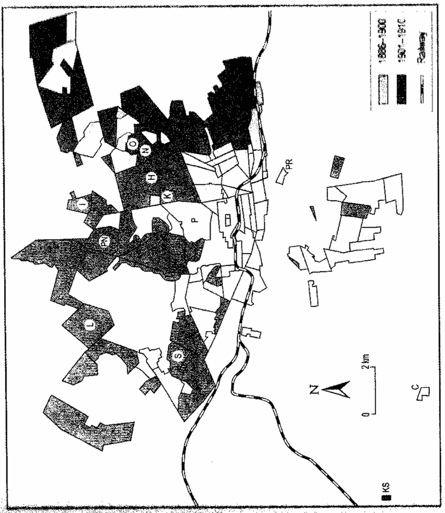
Initially, this Committee sought two separate sites, one for Africans and one for Indians and Coloureds. However, after its efforts to find the latter within a radius of 5–6 miles south or west of Johannesburg yielded nothing suitable,Footnote 66 in desperation (and under intense pressure to act from anxious whites living near Coolie Location)Footnote 67 it opted to lodge both the Africans and the Indians and Coloureds on Klipspruit farm, 12 miles from the city centre (Figure 2).Footnote 68 Not only was part of this farm already owned by the Johannesburg Municipality – it had recently purchased its southern half to serve as a sewage farm – but it also was on the new railway line to Johannesburg.
Klipspruit (marked KS) 12 miles south-west of Johannesburg. With acknowledgement to K.S. Beavon, Johannesburg: The Making and Shaping of the City (Pretoria and Leiden, 2004).
This decision having been unilaterally made, two sites were prepared a mile apart on the farm for the two groups from Coolie Location. While the Indians were assured that in the resettlement ‘attention will be paid to creeds and castes . . . as far as can be [respected] under the peculiar circumstances of their enforced exodus’,Footnote 69 the Africans were encouraged to believe that ‘no doubt [the] sunshine [in the open at Klipspruit] will destroy the germs of the plague’.Footnote 70 The attention of neither group was, however, drawn to an ominous plea to the town council by one of its members at this time that ‘the natives and the Indians should not be allowed to come back to the location’. Indeed, he went on, ‘This plague might thus be a blessing in disguise. He hoped they would never have the natives and the Indians back in the location’, a sentiment which elicited applause from his fellow councillors.Footnote 71
Over the next week, Coolie Location was systematically emptied of its inhabitants who were first medically examined before being marched down to a nearby railway siding under military escort. From there, they were transported in special trucks to Klipspruit where they were put into hastily erected huts and tents in two, racially distinct, isolation camps a mile apart. Each camp was encircled by a contingent of troops to enforce the quarantine strictly. Only clothing, bedding and utensils which had been disinfected were allowed into the camps; all other possessions – save laundry belonging to white customersFootnote 72 – had to be left behind for fumigation or burning. Such high-handed destruction was ‘more in order to fire public imagination [that no chinks were being left in the anti-plague offensive] . . . than to guard against the danger to public health’, observed Gandhi shrewdly,Footnote 73 while the cordon was ‘merely a fiction kept up to satisfy – not the requirements of sanitation – but public sentiment’.Footnote 74
By the end of March, Coolie Location had been cleared of all people; only six African labourers remained on site to pack up belongings left behind by the evacuees.Footnote 75 This situation, the product jointly of whites’ fears, racial prejudice and scapegoating, officials’ contingency planning and authoritarian efficiency and Indians’ complaisance (for which Gandhi did not fail to take credit)Footnote 76 opened the way for the coup de grâce against the plague, countermining a recurrence from the same source by destroying Coolie Location once and for all and replacing it with the salubrious layout envisaged by the Insanitary Area Improvement Scheme.
For the next week, preparations to apply what one town councillor later callously called ‘the fire cure’Footnote 77 were undertaken. First, a corrugated iron fence was erected around the empty Location to stop animals left behind there from escaping. These –and any rats that could be discovered – were then hunted down and killed by a team of municipal employees. (It may or may not be coincidental that at this very time Dr Pakes noted swarms of fleas in the warehouse housing goods left behind by the departed residents and that, soon thereafter, cases of flea-borne bubonic plague began to increase in the city.Footnote 78)
Then, the Johannesburg Fire Department was assigned the paradoxical task of dousing Coolie Location in paraffin and setting it ablaze block by block; any still surviving animals trying to flee were trapped by the fence and killed. Anticipating a ‘rodential holocaust’,Footnote 79 those present were astonished when only one rat appeared among the dogs, cats and chickens.Footnote 80 Maybe it is an indication of the extent to which the press heeded the wishes of the public health authorities that no newspaper commented on this fact which so centrally challenged the latter's premise that plague had arisen from the rat infestation of Coolie Location. Gandhi did not pick up this contradiction either, but he did draw attention to another anomaly, viz. that the torching of Coolie Location was ‘essentially a theatrical display calculated to fire the imagination of the people. While the buildings should certainly have been gutted out, to think that, because they have been burned down, the only source of infection is gone [is] quite contrary to facts.’Footnote 81 Other than by Jeyes fluid and sweeping brooms – ‘everywhere one meets with disinfectant’ noticed one reporterFootnote 82 – buildings and drains in the rest of the Insanitary Area were left untouched.
The few structures still left standing in the razed Coolie Location were consumed in an officially sanctioned follow-up fire three weeks later. The Star's vision of ‘shreds of shrivelled blackness which indicate where the shanties . . . once stood’Footnote 83 and its wish that ‘not a vestige of the Coolie Location remains’Footnote 84 – a vision and a wish shared by most of Johannesburg's whites for a variety of reasons – had finally come true.
Yet, if Yersinia pestis had triggered a re-drawing of the city's racial geography, this was only partial and still very temporary. As the epidemic on the Rand ebbed in the second week of April 1904, leaving 82 of the 113 cases struck by pneumonic or bubonic plague dead,Footnote 85 the cordon around what Gandhi called ‘the wilderness at Klipspruit’Footnote 86 was lifted and a growing number of those who had been forcibly removed there began to filter back into Johannesburg, despite the authorities’ attempts to curb this process and strictly monitor the sanitary quality of their new accommodation in the city.
Turning a temporary camp into a permanent location
The ebbing of the epidemic also allowed minds in the municipality to turn to thinking about how the partial and temporary character of the re-location of some of the population during the epidemic crisis could be extended. Lobbying to do so was coming from several quarters. The colony's Native Affairs Department urged the need for a prompt settlement of where the city's African population should live;Footnote 87 the Johannesburg Chamber of Commerce repeatedly voiced its wish for ‘Asiatic traders’ to be compelled to live and trade away from the city centre;Footnote 88 and the bulk of white residents were determined that there should be no return to the residential status quo ante lest this threaten their health or their commercial and economic activities. ‘We, as Europeans, must live up to a certain standard’, announced one such racial supremacist confidently. ‘Oriental races, on the other hand, are contented to dwell and huddle together in large numbers in hovels, and their living . . . is of the most frugal kind . . . When an epidemic such as the present plague breaks out, is it not notorious that it is always attacks the coloured classes, especially the Orientals?’Footnote 89 Nor was the English-language press on the Rand slow to give its support to such views, also employing the dominant, topical trope of sanitation. For example, the Rand Daily Mail declaimed, ‘[W]ith their filthy habits and gross perversion of the most elementary sanitary rules . . . keep those coolies as far away as possible from centres of population’,Footnote 90 while The Star argued that ‘The advantages of keeping the native living quarters completely away from the white population are at once apparent. The wholesale removal of the natives from the town would place us in a better position to protect ourselves against outbreaks of disease and would lessen their frequency and virulence.’Footnote 91
Under such pressures and in keeping with their own outlook, the Johannesburg municipal authorities began to explore what the chairman of the Public Health Committee felt should be ‘a proper, whole-hearted treatment of this coloured question’ which would unscramble the way in which ‘the Malays, Indians and Kaffirs were jumbled all over the place . . . [alongside] men and women of various colours and nationalities’, all under overcrowded and insanitary conditions.Footnote 92 What these aspirant social engineers wanted instead was a modern, ordered city, with its population clearly sorted by race, class and ethnicity once and for all.
Such a city, they believed, would attract the respectable British immigrants so necessary for the fulfilment of Milner's Anglicization policy. As things stood, argues a historian of Johannesburg's white working-class, ‘the unhealthy conditions and the multiracial component of the area made it thoroughly undesirable for the British workers’ who would have to live in a manner that a witness before the Insanitary Area Improvement Scheme Commission described as ‘repugnant to those who have been used to associate with their equals’.Footnote 93 Making residence in Johannesburg appealing to these workers was so essential to the success of Milner's grand design that, as the city's town clerk put it, ‘the British administration cannot afford to neglect any measure likely to contribute to this end’.Footnote 94
To achieve this, in September 1904 the town's Public Health Committee put forward a two-part scheme which, to some extent, resurrected the stymied Insanitary Area Improvement Scheme of 1903. In terms of its proposals, the Africans already at Klipspruit would remain there permanently and would be joined by the rest of the city's African population, except for those dwelling in mine compounds or on their employers’ premises. In effect, Klipspruit was to become the home to most of Johannesburg's African population, to which end, the committee anticipated, accommodation there would be gradually expanded ‘in order to keep pace with any increase in the number of natives’.Footnote 95 The concentration of Africans at Klipspruit would mean the closure of the so-called ‘Kaffir Location’ adjoining the now blackened site of Coolie Location, as well as the host of private locations dotted around Johannesburg.Footnote 96 Moreover, such steps would fit in well with the Insanitary Area Improvement Scheme as the removals which they involved would free up more land close to the city centre for development in what was already being labelled ‘Newtown’.Footnote 97
Furthermore, unlike the situation in 1903 when the implementation of the Scheme had been obstructed by an inability to find a suitable site which did not trigger whites’ opposition, Klipspruit was so distant and remote from white suburbs – it lay even beyond Johannesburg's far-flung municipal boundary – as to set no white alarm bells ringing. ‘The advantages of keeping the native quarters completely away from the white population, will be obvious to everyone, whether one considers the interests of the native or those of the poorer class of Europeans’, observed the Public Health Committee patronizingly in words echoing The Star’s. ‘Many facilities for keeping order and for efficient sanitary control will be afforded, which the present position of the [Kaffir] location renders far from easy.’Footnote 98 Certainly the ‘nimby-ites’ of Brixton, Vrededorp and Mayfair agreed: their new North-West Suburbs Ratepayers’ Association passed a resolution enthusiastically commending the proposal.Footnote 99
Only those to be moved were unenthusiastic. Over 270 African residents of the Kaffir Location objected to the proposal, declaring that it was ‘not our desire nor wish to go to Klipspruit’. It was too far away, and ‘saying that “There is [sic] Railway Trains” is not in our favour in this respect, as we have to incur more expenses by paying for it’. However, if they were forced to move, they submitted, the least that the town council ought to do was to compensate them for their existing houses which would be demolished.Footnote 100 A decision on this last request the town council deferred, pending receipt of an estimate of the cost involved.Footnote 101
The second part of the Public Health Committee's scheme addressed the issue of how and where to accommodate the city's other sanitary scapegoat, its Indian population. Here, once more, a segregated location (now labelled a ‘bazaar’ in a bout of misconceived Orientalism)Footnote 102 was seen as the answer on health, economic and racial grounds. To the committee, Indians’ ‘deeply ingrained’ insanitary habits, their ‘unfair’ competition with white shopkeepers and hawkers and the ‘deterioration of the white man’ which resulted from ‘social intercourse between the two’ all pointed in one direction, viz. ‘The existence and future of Johannesburg as a white man's town in a white man's country . . . is, in our opinion, involved . . . [as] the proper development of the European population would be endangered by the present state of things.’Footnote 103 Against such grave threats, Klipspruit was also perceived as the only solution for white concerns, though this time it was to be at a site a mile away from where the Africans had been dumped.Footnote 104 Despite its up-beat listing of all the benefits to be gained from concentrating the entire Indian population at an Asiatic Bazaar at Klipspruit, Gandhi had no doubt as to the wish to secure white commercial advantage in the scheme, ‘in naked terms, a policy of slow confiscation . . . slow but sure arsenical poisoning, in the shape of cooping the community up within an enclosure miles away from its scene of [commercial] activity, and letting it die for want of nutrition’.Footnote 105
When the Public Health Committee's proposals came before the full town council on 12 October 1904, Gandhi's critique revived councillors’ concerns that, in legal terms, the municipality would face difficulties if it tried to force Indians to dwell in a particular place except in an emergency, and that the Transvaal government was unlikely to overturn this bar lest it alienate the government of India thereby and so incur a veto from Westminster.Footnote 106 While the city's legal advisors wrestled with this issue, the city's Indian population took the opportunity to vote with their feet and permanently leave Klipspruit for Johannesburg, in particular for its so-called ‘Malay Location’, just across the railway line from their former Coolie Location. By January 1905, almost all the former Coolie Location Indian residents had moved to Malay Location, comprising by then nearly 40 per cent of its population.Footnote 107 During the next three years, 48 stands in this Location were rented to Indians,Footnote 108 giving it an increasingly Indian character as it was transformed into Pageview.
To the Africans, stuck out at Klipspruit, no such legal loophole was available. ‘If they allowed the natives to come back now’, warned one town councillor, ‘they were simply going to let them be there for ever.’Footnote 109 Nor was the legal means to keep them there lacking. In terms of a municipal by-law passed at the beginning of the year, every African in Johannesburg not staying on an employer's premises had to live in a designated location.Footnote 110 Now, despite the Transvaal government's concerns that this would interfere with the steady supply of African labour to the city,Footnote 111 the Johannesburg Town Council announced that Klipspruit was to be that designated location and that it would enforce the by-law with effect from 1 April 1906. On that date, those Africans still at Kaffir Location were removed to Klipspruit, followed a few days later by those from elsewhere in the city, under the watchful eye of Dr Porter who had been instructed by the Public Health Committee to ‘shepherd’ them thither.Footnote 112 By 1907, some 1,800 Africans were in residence there, and a year later, 2,500.Footnote 113
From Klipspruit to Soweto
Despite its distance from Johannesburg, its proximity to a sewage farm and its generally insalubrious living conditions, Klipspruit thereafter remained a prime centre of residence for the city's Africans, even after the ‘Western Native Township’ was established closer to central Johannesburg after 1918, in the wake of another epidemic (that of ‘Spanish’ influenza). Klipspruit's chief appeal lay in the space for expansion which it continued to offer.
Accordingly, when in 1930, the Johannesburg City Council decided to build what it intended to be ‘the biggest and finest township in the Union of South Africa’,Footnote 114 it chose land adjoining Klipspruit for its new Orlando Township. The southern part of Klipspruit, it renamed Pimville. Around this nucleus, subsequent townships were constructed at an accelerating pace after World War II to accommodate the thousands of Africans flocking to Johannesburg, so that by the 1950s the central government's Native Areas Planning Committee proposed that, henceforth, ‘The native residential areas [of Johannesburg] will be concentrated to the south-west of the City where the [Johannesburg City] Council already owns 6181 acres of land . . . to the west of which the Committee considers is adequate vacant land to serve as a hinterland for future expansion.’Footnote 115 This recommendation, the apartheid government accepted. With 26 such residential townships in existence by 1959, housing close to half-a-million Africans, the Johannesburg City Council decided that they needed the corporate identity of an overarching name. In 1963, the Naming Committee of the Council's Department of Non-European affairs chose the acronym ‘Soweto’,Footnote 116 at the heart of which lay the original Klipspruit Location dating back to the hasty plague removal as a result of Yersinia pestis 59 years earlier. From small germs do mighty townships grow.
Yet, if the line from Klipspruit to Soweto is clear – Beavon speaks of how the selection of the former ‘effectively determined the future site for . . . Soweto’Footnote 117 – this article also reveals that the choice of Klipspruit was by no means straightforward, carefully planned or without paradox.
Not only was Klipspruit just one of several sites originally considered – the committee ‘went east, west, north and south’ looking for a suitable site, recalled one councillorFootnote 118 – but it was finally selected in haste by a short-lived, ad hoc committee representing not Johannesburg but the whole of the Witwatersrand (the Rand Plague Committee), amidst the panic of an outbreak of pneumonic plague and under pressure from fearful whites living close to Coolie Location.
Moreover, although the 1,420 Africans removed to Klipspruit from Coolie Location constituted but a fragment (less than 10 per cent of the city's Africans not living in a mine compound),Footnote 119 their presence at Klipspruit was used as justification for that place becoming the site of municipal choice for settling all the city's Africans not living on their employers’ premises. The removal there of the African inhabitants of Coolie Location was the thin edge of a segregationist wedge and a precursor to many subsequent forced removals there. Taking this with the equally paradoxical fact that they (and not the Indians who had been far worse hit by the plague at Coolie Location) were compelled to remain at Klipspruit points very strongly to full-scale segregation of Johannesburg's Africans being a deliberate long-term goal of the new, British-dominated municipality and its advisors as they sought to re-shape the city and thereby help transform the Transvaal into an efficient and loyal British colony. For them, the plague crisis was an ideal opportunity to accomplish this goal swiftly and without resistance, something which would not easily have been possible under normal circumstances, as the events of 1903 had shown.
The power of plague
This raises the question as to what was so potent about the plague crisis in 1904 that made such drastic action possible. Swanson has already argued with regard to the creation of African locations in Cape Town and Port Elizabeth during the bubonic plague outbreaks there three years earlier, that disease was both a powerful ‘biological fact and a social metaphor’,Footnote 120 something which the Johannesburg case strongly confirms. One only has to recall the rhetoric cited above to recognize it as coming from fearful people whose attitudes to others had been laid bare by the perceived threat to their own lives.
To this explanation, the Johannesburg experience in 1904 does add two dimensions, however. The one is that plague, in any form, had a peculiarly terrifying effect on anyone raised in a European cultural tradition, thanks to the ghastly tales of the ‘Black Death’ and Great Plague of London, which had impressed themselves on the European mind. Plague possesses the ‘richest genealogy of fear in the Western psyche’, notes a historian of its impact on San Francisco.Footnote 121 This component of all white Johannesburgers’ mentalité has to be factored into our understanding of their words and actions in 1904.
Secondly, the fact that the outbreak occurred in 1904 is also significant, for at this very time, the aetiology of the disease was being unravelled by biomedicine as part of a global response to the pandemic which had begun in earnest in 1894. By 1904, the causative pathogen had been identified and its mode of transmission partly established. This gave to doctors like Porter and Pakes unprecedented say in policy-making in an environment in which an outbreak of plague was feared. If, even before the outbreak in March 1904, what they said went, once it exploded, their words went even further.
Their opinion and those of their fellow doctors were therefore critical to the dramatic, draconian steps taken. The conjuncture of plague and all that it connoted, the enhanced self-belief of the medical profession and the newly acquired status which it enjoyed thanks to the germ revolution combined to give them the first and last words on how to handle the outbreak of plague. Only this combination made possible the rapid, wholesale removal of over 3,000 inhabitants of Coolie Location to a site 12 miles away, the torching of the Location and the subsequent closure of Kaffir Location. These were the products of a new brand of medically informed policy-making, one which made the old Transvaal Republic's haphazard delineation of locations for Johannesburg in the 1880s and 1890s look quite outmoded. ‘[I]ncomplete, ineffective and ignored’Footnote 122 in the modern, British, Johannesburg, these locations were to be superseded by the products of social engineering on a vast scale.
In the light of these perspectives, it is perhaps necessary to revise the glib conclusion in the first paragraph on page 21 thus: using the presence of ovoid, 1.5 × 0.7 nanometre small, bacteriologically identified germs and the folk memories and connotations which they triggered, determined and powerful social engineers and doctors ignored logic, liberties and location to reshape a city. A messier conclusion, to be sure, but one that more accurately captures the paradoxes behind why Soweto is where it is.