Introduction
Periglacial landforms are a major feature across polar desert landscapes of both hemispheres (Campbell & Claridge Reference Campbell and Claridge1987, Bockheim Reference Bockheim2002, Marchant et al. Reference Marchant, Lewis, Phillips, Moore, Souchez, Denton, Sugden, Potter and Landis2002, French Reference French2007) and their occurrence and activity are key factors affecting soil development as well as vegetation colonization and succession. The disturbance associated with periglacial features is mainly related to the action of permafrost, cryoturbation and frost heave, (e.g. Washburn Reference Washburn1979, Williams & Smith Reference Williams and Smith1989), which affects the development, composition and distribution of vegetation (Jonasson & Sköld Reference Jonasson and Sköld1983, Anderson & Bliss Reference Anderson and Bliss1998, Cannone et al. Reference Cannone, Guglielmin and Gerdol2004, Walker et al. Reference Walker, Epstein, Gould, Kelley, Kade, Knudson, Krantz, Michaelson, Peterson, Ping, Raynolds, Romanovsky and Shur2004, Kade et al. Reference Kade, Romanovsky and Walker2006).
In the Arctic several authors have investigated the relationships between periglacial features (e.g. patterned ground) and vegetation (e.g. Jonasson & Sköld Reference Jonasson and Sköld1983, Anderson & Bliss Reference Anderson and Bliss1998, Walker et al. Reference Walker, Epstein, Gould, Kelley, Kade, Knudson, Krantz, Michaelson, Peterson, Ping, Raynolds, Romanovsky and Shur2004, Cannone et al. Reference Cannone, Guglielmin and Gerdol2004), showing that the type and the rate of the periglacial processes related to the features strongly influences vegetation composition, cover and dynamics (e.g. Walker et al. Reference Walker, Epstein, Gould, Kelley, Kade, Knudson, Krantz, Michaelson, Peterson, Ping, Raynolds, Romanovsky and Shur2004, Cannone et al. Reference Cannone, Guglielmin and Gerdol2004, Haugland Reference Haugland2006).
The relationship between periglacial features and vegetation has been poorly addressed in Antarctica (e.g. Holdgate et al. Reference Holdgate, Allen and Chambers1967, Heilbronn & Walton Reference Heilbronn and Walton1984, Cannone & Guglielmin Reference Cannone and Guglielmin2009), although the widespread occurrence of such associations is recognized (Campbell & Claridge Reference Campbell and Claridge1987, French & Guglielmin Reference French and Guglielmin1999, Bockheim Reference Bockheim2002) and their probable influence on soil characteristics, development and soil biota (e.g. Barrett et al. Reference Barrett, Virginia, Wall, Parsons, Powers and Burkins2004, Reference Barrett, Virginia and Parsons2006) and vegetation (Cannone & Guglielmin Reference Cannone and Guglielmin2009) has been demonstrated. Some periglacial features indeed provide particular micro-topographical and micro-edaphic conditions, relating to the micro-relief, the associated shelter or disturbance effects on plants, the patterns of snow accumulation and persistence, etc. On the other hand, vegetation influences the ground thermal regime through its buffering effect (e.g. Cannone et al. Reference Cannone, Ellis Evans, Strachan and Guglielmin2006, Guglielmin et al. Reference Guglielmin, Ellis Evans and Cannone2008, Kade & Walker Reference Kade and Walker2008, Cannone & Guglielmin Reference Cannone and Guglielmin2009), with potential feedbacks on active layer thickness and freeze-thaw cycles, and may influence soil chemical characteristics (e.g. Cannone et al. Reference Cannone, Wagner, Hubberten and Guglielmin2008). To our knowledge, until now there have been no specific investigations comparing vegetation patterns with the periglacial landform types in continental Antarctic.
This paper aims to contribute to the LGP key question “How does soil development influence terrestrial ecosystems” in order to assess how periglacial features influence ground thermal regime and vegetation colonization in northern Victoria Land. We aim to understand which are the key factors (feature type, microtopography, site location) and at what spatial scale they are effective in shaping vegetation patterns.
Study areas
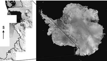
Four sites in northern Victoria Land (continental Antarctic) were selected for this investigation and used as a template for the conditions of continental Antarctic (Fig. 1).
Location of the study sites at Victoria Land (continental Antarctic). Legend: AI = Apostrophe Island, BC = Boulderclay, GO = Gondwana, TF = Tarn Flat. (Images from Landsat Image Mosaic of Antarctica, LIMA, International Polar Year 2007–08 Project by BAS, USGS, NSF)

The climate of northern Victoria Land is frigid Antarctic, with a mean annual air temperature of -18°C and precipitation, always in the form of snow, between 100 and 400 mm yr-1 (Monaghan et al. Reference Monaghan, Bromwich, Fogt, Wang, Mayewski, Dixon, Ekaykin, Frezzotti, Goodwin, Isaksson, Kaspari, Morgan, Oerter, van Ommen, van der Veen and Wen2006). In the vicinity of Mario Zucchelli Station, at Boulderclay (74°43′S, 164°05′E) the mean annual air temperature for the period 1997–2003 ranged between -16.4°C and -15.1°C (Guglielmin Reference Guglielmin2006).
Four study sites were selected: Tarn Flat (74°59′S, 162°37′E), Boulderclay (74°44′S, 164°05′E), Gondwana (74°36′S, 164°12′E), and Apostrophe Island (73°30′S, 167°50′E). All sites are located along the coast, with the exception of Tarn Flat (which is some kilometres inland), at elevations ranging from 20 to 150 m a.s.l. They are ice-free areas, with continuous permafrost, and active layer thickness ranging from 20 cm to more than 100 cm (Guglielmin Reference Guglielmin2006). At Boulderclay, during the period 1997–2003, the active layer thickness ranged between 5 and 93 cm (Guglielmin Reference Guglielmin2006) while in the coastal areas of the McMurdo region it ranged between 20 and 90 cm (Adlam et al. Reference Adlam, Balks, Seybold and Campbell2010).
The study sites are characterized by different outcropping rock types (gabbro at Apostrophe Island, gneiss at Gondwana, granites at Tarn Flat and Boulderclay) partially or totally covered by a mantle of glacial deposits (mainly ablation till).
Widespread periglacial features include large polygons (size 15–20 m) with frost-fissure polygons (French & Guglielmin Reference French and Guglielmin2000), and also ice-wedge polygons (Raffi et al. Reference Raffi, Stenni, Flora, Polesello and Camusso2005), and smaller sorted circles and/or polygons (size 0.3–1.5 m) generally with a higher centre (“debris island”, according to French Reference French2007). Gelifluction features are widespread on many slopes (Baroni Reference Baroni1987). French & Guglielmin (Reference French and Guglielmin1999) underlined that the main part of these terraces do not show any preferential distribution to either aspect or exposure, and could be interpreted as the results of the underlying ice or fractured bedrock, without the need to evoke gelifluction movements. There are also stone-banked lobes and terracettes preferentially located on gentle slopes (< 10°) and possibly related to gelifluction.
The vegetation of Victoria Land is a cryptogamic non-vascular tundra including different moss and lichen dominated associations (Longton Reference Longton1979). Descriptions of the moss and lichen flora and of the main vegetation communities of Victoria Land have been provided by several authors (Kappen Reference Kappen1985, Castello & Nimis Reference Castello and Nimis1995, Seppelt et al. Reference Seppelt, Green and Schroeter1995, Seppelt & Green Reference Seppelt and Green1998, Cannone Reference Cannone2005, Reference Cannone2006, Cannone & Seppelt Reference Cannone and Seppelt2008).
Methods
Geomorphology
The geomorphological study was performed by means of field surveys. Periglacial landforms occurring in each selected study site were recorded and classified according to Washburn (Reference Washburn1979) and French (Reference French2007). Patterned ground types were separated according to their shape (circle vs polygons), and size. In addition, field surveys focussed also on the occurrence of sorting or the role of cracking. Gelifluction features were classified in lobes and terracettes according to the ratio between length and width. In some representative cases the landforms selected for the vegetation survey were also morphometrically characterized through profiles and visual descriptions. Trenches were dug into the ground to investigate the internal structure of the features and for sampling.
At Gondwana the ground surface temperature (GST) of the centres and the borders of two polygons (A and B) was monitored during the peak of the summer season (12 December 2002–10 January 2003). Also at Boulderclay the GST of the centres of two debris islands (one vegetated and one not vegetated) was monitored during the peak of the summer season (11 December 2001–11 February 2002) in the same way. In addition at Boulderclay a second thermistor was placed at a depth of 30 cm. The ground surface temperature was measured at a depth of 2 cm as that is the depth that represents the best possible compromise between avoiding any disturbance of the surface characteristics and achieving a more accurate GST according to Guglielmin (Reference Guglielmin2006) and Osterkamp (Reference Osterkamp2003). The 30 cm depth was selected because it is reasonably close to the average of the permafrost table depth in the selected sites. Moreover, it is easily reachable without heavy logistics and environmental impact and it is comparable with the other dataset from Antarctica (see http://soils.usda.gov/survey/scan/antarctica/index.html). All thermistors had a minimum accuracy of 0.2°C. The data were recorded every 10 min by mini-datalogger (Hobo Pro by Onset Comp). Air temperature at Boulderclay and Oasi sites (74°42′S; 164°07′E) was measured at 1.5 m above the ground with thermisthors having an accuracy of 0.1°C shielded from direct sunlight by screens.
Vegetation survey
The vegetation was sampled in 50 × 50 cm plots. Two (occasionally three) plots were set up at each of the selected landforms. All plots were located in morphologically homogeneous microhabitats within the landforms (e.g. border vs. centre of patterned ground). All of the moss and lichen species occurring in the plot were recorded and their percentage cover estimated visually. Microtopography and surface-soil texture (grain size) were assessed visually in each plot. Species nomenclature follows Castello & Nimis (Reference Castello and Nimis2000), Øvstedal & Lewis Smith (Reference Øvstedal and Lewis Smith2001) and Castello (Reference Castello2003) for lichens, and Ochyra et al. (Reference Ochyra, Lewis Smith and Bednarek-Ochyra2008) for bryophytes.
Data elaboration
Ground temperature at 2 cm and 30 cm depth and, for comparison, air temperature (where available) were used to calculate the freezing degree days (FDD, sum of degree days below 0°C), the thawing degree days (TDD, sum of degree days above 0°C) and the potential freeze-thaw cycles (the temperature cycle through a threshold at 0°C).
The data from the vegetation surveys were used to perform (through the software Statistica®) a hierarchical classification (dendrogram) applying the weighted pair-groups average joining rule and the percent disagreement as linkage distance, based on floristic composition. The hierarchical tree matrix comprised 53 vegetation surveys.
The vegetation data and the environmental data (relating to the feature type and location, i.e. flat versus slope of terracettes, grain size, total cover) were used to carry out multivariate analysis (Redundancy Analysis, RDA) using the software CANOCO for Windows (Ter Braak & Smilauer Reference Ter Braak and Smilauer1998). Two RDA were carried out separately: 1) involving all the investigated sites, vegetation surveys and features to assess the relations between vegetation and periglacial features among sites, and 2) using only the data relating to the Gondwana site (because only here were all the landform types present) to assess whether the feature type influences the patterns of vegetation colonization independently from the site location (intra-site).
Results
Geomorphology
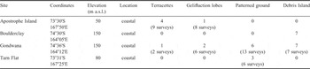
Three different periglacial feature types were analysed at four different sites (Table I): a) sorted patterned ground (debris island at Boulderclay, high centred patterned ground at Gondwana, Tarn Flat and Apostrophe Island), b) terracettes (Tarn Flat, Gondwana, Apostrophe Island), and c) gelifluction lobes (Gondwana, Apostrophe Island).
Site location and number of investigated features and vegetation surveys.

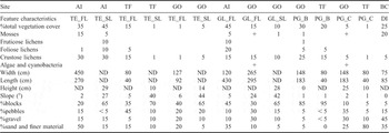
High centred patterned grounds show variable size (Table II), ranging from 80–150 cm in width and 40–180 cm in length, with elongated shape, coarser and depressed borders and finer raised centres. The debris islands are characterized by a smaller size (c. 80 x 80 cm), rounded shape and finer texture at the centre.
Average total vegetation cover and floristic composition, morphometrical characteristics and surface grain texture of the different elements of the investigated periglacial features in all selected sites. Sites: AI = Apostrophe Island, BC = Boulderclay, GO = Gondwana, TF = Tarn Flat. Vegetation cover: + = < 1%. Features: DI = debris island, GL_FL = gelifluction lobes flat, GL_SL = gelifluction lobes slope, PG_B = high centred patterned ground border, PG_C = high centred patterned ground centre, ND = not determinable, TE_FL = terracettes flat, TE_SL = terracettes slope.

The terracettes are highly variable in size (Table II), both in width and length, with a slope of about 5° for the tread and higher (25°) for the riser. Gelifluction lobes show a variable size and are mainly larger than terracettes, while their texture is similar for both the tread and the riser. The height of the terraccettes and of the gelifluction lobes ranges between 10 cm and 35–40 cm.
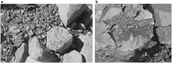
Frost heave evidence (vacuolar structure of the sediment) in the upper 3–4 cm of the patterned ground centres occur almost everywhere, while they were observed only on one tread of a terracette at Gondwana. Cryoturbations occur in the centres of the debris island at Boulderclay (Fig. 2) and in one section of the gelifluction lobe at Apostrophe Island. The permafrost table is shallow and ranges from 15–50 cm in depth. Groundwater flow was observed only in one of the cut trenches, at a gelifluction lobe on Apostrophe Island. The absence of low centred patterned ground is remarkable from the geomorphological point of view.
a. Debris island investigated at Boulderclay, with b. cryoturbations in the centre (as shown by the section).

Vegetation
Vegetation shows different colonization patterns (for total vegetation cover and community type) in relation to the feature type, their micro-morphology (and associated micro-relief) and texture (Table II). The highest total vegetation cover occurs on the tread of terracettes and gelifluction lobes at Apostrophe Island and on the coarse border of high-centred patterned ground and debris islands, whereas the centre of high-centred patterned ground, the riser of gelifluction lobes and terracettes show the lowest total vegetation cover (Table II). Within the patterned ground there is a vegetation zonation with a non-linear cover increase from the centre outwards to the border. The core of the centres is devoid of vegetation. Indeed, vegetation tends to be located close to the boundary between centres and borders (data not shown), while the borders of the patterned grounds show the highest vegetation.
Vegetation is mainly composed of crustose lichens, which are able to colonize all the features and show a much higher cover and distribution than foliose and fruticose lichens. Mosses show very low cover and are mainly associated with debris islands, where they reach cover of up to 20%. Generally, at Apostrophe Island (the northernmost investigated site) vegetation covers tends to be higher, independently from the feature type.
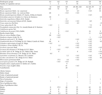
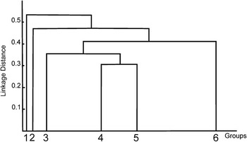
The dendrogram obtained by the hierarchical classification (Table III, Fig. 3), shows six different groups based on their floristic composition. Group 1, is separated from all the other groups, belongs to the lichen-encrusted bryophyte formation and is characterized by the dominance of Bryum argenteum var. muticum and Schistidium antarctici encrusted by epiphytic lichens, mainly Candelariella flava and Physcia caesia.
Floristic composition and species coverage (%) of the groups obtained by the hierarchical classification.

Dendrogram showing the hierarchical classification of the periglacial features vegetation at Victoria Land (see Table III for groups floristic composition and characteristics).

All the other groups are dominated by lichens, with bryophytes playing a minor role in their floristic composition. Group 2 lies separately from the others due to the dominance of Rhizocarpon geminatum (a very common species at Gondwana) associated with Lecidella siplei, Umbilicaria decussata, Buellia frigida and mainly occurring on the stony borders of high-centred patterned grounds. Group 3 is characterized by cyanobacteria with Syntrichia magellanica, Turgidosculum complicatulum and a high cover of the eutrophic green alga Prasiola crispa, within the pure bryophyte formation. Group 4 is characterized by scattered bryophytes (mainly Bryum argenteum var. argenteum) encrusted by Lecidella siplei (which is able to grow directly also on ground and pebbles) and by Buellia frigida. Group 5 belongs to the macrolichen formation, being dominated by Umbilicaria decussata, Usnea sphacelata and Buellia frigida. Group 6 is characterized by the dominance of bryophytes and macrolichens, with Bryum argenteum var. argenteum, Umbilicaria decussata and Usnea sphacelata, accompanied by Buellia frigida and by the epiphytic lichens Candelariella flava and Leproloma cacuminum.
Influence of periglacial features on the ground thermal regime at the local scale
The summer season (December–February) accounts for almost all the TDD of the full year both for the bare ground and the vegetated ground, although the average air temperature of the summer season is negative and, for this reason (as well as for logistical constraints), the period of GST measurements was limited to the summer season.
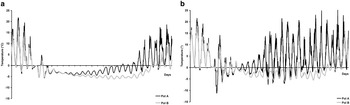
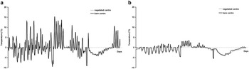
The GST measurements of the summer 2002–03 in the centre and in the border of two high-centre polygons located at Gondwana show that in both polygons the centres are colder than the borders. For the whole period the average temperature difference between border and centre is higher in polygon A (2.8°C) than in polygon B (1.6°C) (Fig. 4a & b).
Effect of microtopography on the ground surface temperature (°C) recorded at depth of 2 cm in two high centred polygons (A, B) at Gondwana during the peak of summer season (12 December 2002–10 January 2003). a. centre, b. border.

The GST diurnal fluctuations are influenced by micromorphology and range between 6.3 and 17°C within the borders but are more limited in the centres (3.4–6.3°C). Moreover, the centre of polygon B experienced a period of zero curtain effect (stable temperature close to the melting point) between 6 and 7 January 2003.
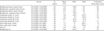
The number of potential freeze-thaw cycles (Table IV) is always higher in the borders than in the centres. Polygon A shows the highest variability of freeze and thaw cycles (24 in the border, 14 in the centre). On the contrary the freezing degree days (FDD) is much higher in the centres than in the borders in both polygons.
Mean temperature values, freezing degree days (FDD), thawing degree days (TDD) and potential freeze-thaw cycles recorded on patterned ground at Boulderclay and Gondwana during the peak of the summer seasons 2001/02 and 2002/03 and, for comparison, on two vertical rock surfaces at Oasi and of air.

Vegetation occurrence influences the GST within the periglacial features even with discontinuous cover and composed only by cryptogams. At Boulderclay (Fig. 5a) the average GST is lower (-0.6°C) in the centre of the vegetated polygon (70% of Bryum argenteum with epiphytic lichens) than in the barren one (0.2°C). The effect of vegetation is even greater considering only the periods with positive temperature, as demonstrated by the difference between the thawing degree days (TDD) in the barren polygon (82) respect to the vegetated one (38). On the other hand, the FDD are almost equal (-66.9 in the barren polygon vs -78.1 in the vegetated). Also the diurnal amplitude of temperature fluctuations (Fig. 5a) and the potential freeze-thaw cycles (Table IV) are at least double in the barren polygon than in the vegetated one. At the depth of 30 cm, not so far from the permafrost table (depth of 0°C isotherm), the TDD is still more than the double in the barren polygon than in the vegetated one (Fig. 5b).
Effect of vegetation occurrence on the ground surface and active layer temperature (°C) in the centre of two debris islands (vegetated vs. bare ground) at Boulderclay during the peak of summer season (11 December 2001–11 February 2002) recorded at depth of a. 2 cm, b. 30 cm.

Relationships between vegetation and periglacial features
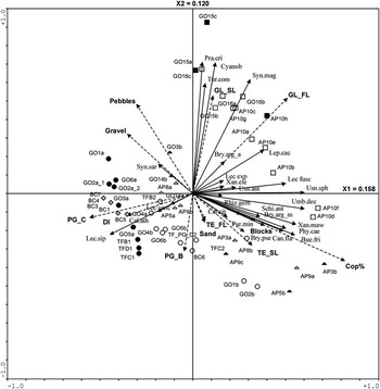
The redundancy analysis (RDA) (Fig. 6) performed for all the sites, periglacial features and vegetation surveys shows a clear separation of three main clusters relating to: a) feature type (gelifluction lobes vs. terracettes and stony borders of patterned ground versus centres of patterned ground and debris islands), b) floristic composition/dominant vegetation type (cyanobacteria with bryophytes versus macrolichens and crustose lichens versus scattered bryophytes with epiphytic and ground lichens), c) surface texture with a separation between blocks and sand versus pebbles and gravel. The vegetation clusters are associated with the periglacial feature clusters, in particular: 1) cyanobacteria and bryophytes with gelifluction lobes, 2) macrolichen dominated vegetation with terracettes and stony borders of patterned ground, and 3) scattered bryophytes and Lecidella siplei with centres of the patterned grounds and debris islands. The highest vegetation cover occurs on the coarsest features (i.e. the stony borders of the patterned grounds). The site location of the surveys does not affect the observed patterns, showing that the feature type, the dominant vegetation and the surface texture are more important than the site location.
Species-site-environmental factors diagram of the Redundancy Analysis (RDA) at four sites at Victoria Land to assess the relations between vegetation and the investigated periglacial features. Legend: white circle = patterned ground border, black circle = patterned ground centre, white triangle = terracettes flat, black triangle = terracettes slope, white square = gelifluction lobe flat, black square = gelifluction lobe slope, black rhombos = debris island, AI = Apostrophe Island, BC = Boulderclay, GO = Gondwana, TF = Tarn Flat. Species abbreviation: Bue.fri = Buellia frigida, Bry.arg_a = Bryum argenteum var. argenteum, Bry.arg_m = Bryum argenteum var. muticum, Bry.pse = Bryum pseudotriquetrum, Cal.ath = Caloplaca athallina, Cal.cit = Caloplaca citrina, Can.fla = Candelariella flava, Cyanob = Cyanobacteria, Lec.exp = Lecanora expectans, Lec.fusc = Lecanora fuscobrunnea, Lec.sip = Lecidella siplei, Lep.cac = Leproloma cacuminum, Phy.cae = Physcia caesia, Pse.min = Pseudephebe minuscula, Pra.cri = Prasiola crispa, Rhiz.gem = Rhizocarpon geminatum, Schi.ant = Schistidium antarctici, Syn.mag = Syntrichia magellanica, Syn.sar = Syntrichia sarconeurum, Tur.com = Turgidosculum complicatulum, Umb.dec = Umbilicaria decussata, Usn.ant = Usnea Antarctica, Usn.spha = Usnea sphacelata, Xan.ele = Xanthoria elegans, Xan.maw = Xanthoria mawsonii.

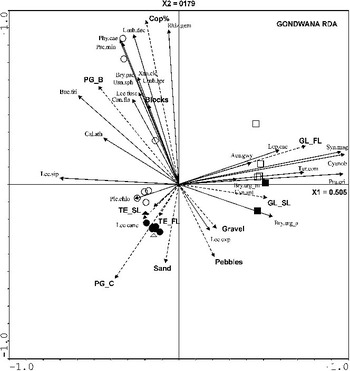
To assess whether the feature type influences, at local scale, the patterns of vegetation colonization, the RDA was performed only at Gondwana, where all the investigated feature types occurred (with the exception of the debris island) (Fig. 7). Also in this case there is a similar separation between the feature types, even more effective, due to the larger separation of the stony borders from the centres of the patterned grounds. The prevailing vegetation types are the same as those already observed for the RDA relating to all sites (Fig. 6).
Species-site-environmental factors diagram of the Redundancy Analysis (RDA) at Gondwana to assess at the local scale the relations between vegetation and the investigated periglacial features. Legend: white circle = patterned ground border, black circle = patterned ground centre, white triangle = terracettes flat, black triangle = terracettes slope, white square = gelifluction lobe flat, black square = gelifluction lobe slope, black rhombos = debris island, AI = Apostrophe Island, BC = Boulderclay, GO = Gondwana, TF = Tarn Flat. Species abbreviation: Aca.gwy = Acarospora gwynnii, Bue.fri = Buellia frigida, Bry.arg_a = Bryum argenteum var. argenteum, Bry.arg_m = Bryum argenteum var. muticum, Bry.pse = Bryum pseudotriquetrum, Cal.ath = Caloplaca athallina, Can.fla = Candelariella flava, Cyanob = Cyanobacteria, Lec.exp = Lecanora expectans, Lec.fusc = Lecanora fuscobrunnea, Lec.can = Lecidea cancriformis, Lec.sip = Lecidella siplei, Lep.cac = Leproloma cacuminum, Phy.cae = Physcia caesia, Ple.chlo = Pleopsidium chlorophanum, Pse.min = Pseudephebe minuscula, Pra.cri = Prasiola crispa, Rhiz.gem = Rhizocarpon geminatum, Syn.mag = Syntrichia magellanica, Tur.com = Turgidosculum complicatulum, Umb.apr = Umbilicaria aprina, Umb.dec = Umbilicaria decussata, Usn.ant = Usnea antarctica, Usn.spha = Usnea sphacelata, Xan.ele = Xanthoria elegans.

Discussion
Influence of periglacial features on the ground thermal regime at the local scale
The GST recorded during the summer on patterned ground in both sites, independently from microtopography (borders vs. centres), show higher temperatures than in air (Table IV), similar to the ground in undisturbed conditions, mainly due to the effect of solar radiation (Guglielmin Reference Guglielmin2006, Cannone & Guglielmin Reference Cannone and Guglielmin2009, Adlam et al. Reference Adlam, Balks, Seybold and Campbell2010).
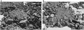
Our results confirm the importance of microtopography on the GST regime within patterned ground: centres show lower daily temperature fluctuations, a smaller number of potential freeze-thaw cycles, higher FDD, and are always colder than borders. Centres exhibit higher relief (> 15 cm) and lower roughness (due to their finer and more homogeneous texture and to their sub-horizontal slope, < 2°) than the borders. Differences of a few centimetres in the topography (e.g. polygon A vs polygon B at Gondwana, Fig. 4a & b, Fig. 8) are able to significantly change the surface roughness (also in the barren surfaces), modifying the wind speed and, consequently, the drifting of the snow (Liston et al. Reference Liston, McFadden, Sturm and Pielke2002, Guglielmin Reference Guglielmin2006) and, as a cascade effect, the snow accumulation, depth and persistence. Indeed, field observations show different patterns of snow accumulation and persistence between the depressed border and the centre (Fig. 8). Moreover, the lower wind speed caused by the higher roughness on the borders may also reduce the sensible heat flux from the surface to the atmosphere, explaining the higher GST recorded in the borders. The differences in GST and snow accumulation within, as well as between, sites may cause large spatial variability of the active layer thickness (Guglielmin Reference Guglielmin2006), whose patterns are not influenced by the main latitudinal and climatic gradient (Guglielmin et al. Reference Guglielmin, Balks and Paetzold2003).
Patterned grounds (polygons A and B) at Gondwana. Field observations show different patterns of snow accumulation and persistence between the depressed border and the centre and among the two polygons, according to their micro-relief.

Vegetation occurrence is another factor able to influence the GST of patterned ground, as shown at Boulderclay (Fig. 5a & b). Indeed, our data confirm the insulating effect with a net cooling exerted by moss-dominated vegetation on the GST during the summer, as reported for undisturbed ground conditions by Cannone & Guglielmin (Reference Cannone and Guglielmin2009). Vegetation effects smooth the temperature wave (with respect to the barren ground), reducing the amplitude of daily temperature fluctuations, the number of potential freeze-thaw cycles and increasing the FDD. These data confirm the results of manipulation experiments carried out in northern Alaska (c. 70°N) on non sorted circles by Kade & Walker (Reference Kade and Walker2008) showing that moss additions lowered soil-surface temperatures in the summer, delayed freezing and thawing, and decreased frost heave.
Relationships between vegetation and periglacial features
In Antarctica the relations between vegetation pattern and periglacial features have been poorly addressed for the continental Antarctic (e.g. Cannone & Guglielmin Reference Cannone and Guglielmin2008), the maritime Antarctic (e.g. Holdgate et al. Reference Holdgate, Allen and Chambers1967), and the sub-Antarctic (Heilbronn & Walton Reference Heilbronn and Walton1984). Our data show that the feature type is more effective than the site location in influencing the patterns of vegetation floristic composition (Fig. 6). The association between vegetation and periglacial feature suggest a possible control of the feature type and ground texture on vegetation cover as well as its floristic composition, independent of the slope (Figs 6 & 7).
Lacking measurements of horizontal displacement and frost heave, only speculative comments are possible on the effect of the morphological disturbance on the vegetation. However, frost heave evidence (very surficial, upper 3–4 cm) were observed on all the patterned ground centres but only in one flat of terracettes at Gondwana.
Vegetation cover may provide an indirect evidence of disturbance associated with frost heave (e.g. Ballantyne & Matthews Reference Ballantyne and Matthews1982, Haugland Reference Haugland2006). In our case, the cryptogamic vegetation, lacking roots, is totally exposed to frost heave disturbance, which is active only in the first few centimetres from the ground surface. Indeed, our data, show the highest vegetation cover on the stony borders of patterned grounds and the lowest in the fine centres of these features and in debris islands, where the frost heave is likely to be higher. On the other hand, the lower number of potential freeze-thaw cycles measured in the centres compared to the borders of patterned ground (12 vs 24 polygon A and 7 vs 11 polygon B, see Table IV) seems to suggest an opposite frost heave trend. According to Williams & Smith (Reference Williams and Smith1989) and French (Reference French2007), the finer material is more frost susceptible and exhibits a higher water retention capacity than the coarser material. For these reasons, in such an extremely dry environment like continental Antarctica (e.g. Cannone et al. Reference Cannone, Wagner, Hubberten and Guglielmin2008), higher frost heave is more likely to occur in the fine centres than in the stony borders of patterned ground. Further, texture is not the only leading factor for frost heave, as indicated by the absence of frost heave evidence in all the treads of gelifluction features where fine material occurs (except for one terracette at Gondwana). Gelifluction features are located on steeper slopes with better water drainage. Moreover, the trenches dug in these features reveal an “en masse” movement (e.g. French Reference French2007) with the possible highest movement close to the permafrost table. For these reasons, features such as gelifluction lobes and terracettes do not disturb the growth of cryptogams and, therefore, are less limiting than the patterned ground centres for vegetation development.
The microtopography (and micro-relief) associated with periglacial features provides several micro-niches with different micro-edaphic and micro-environmental conditions, mainly relating to wind exposure, snow accumulation and persistence, and thus water availability. In particular, the slopes of terracettes and gelifluction lobes are generally less wind-exposed and snow cover persists for a longer time, providing water supply for vegetation, which is characterized by the occurrence of chionophilous foliose and fruticose lichens (e.g. Usnea sp., Pseudephebe minuscula) (Cannone & Seppelt Reference Cannone and Seppelt2008) and mesic mosses. The zonation of vegetation within patterned grounds (centres versus borders) and its different floristic composition underlines the different ecological conditions associated with microrelief (and consequent wind and snow patterns), with scattered xeric mosses (Syntrichia sarconeurum) and ground lichens (Lecidella siplei) in the centres and chionophilous species along the borders.
The relationships between vegetation and the investigated periglacial features in continental Antarctic are similar to those described for the Arctic, although in this part of Antarctica vegetation is exclusively composed of cryptogams. Frost heave, ground texture and relief associated with the different types of periglacial features provide a range of ecological niches sustaining vegetation biodiversity. Within terrestrial ecosystems these data confirm the importance of periglacial features in shaping flora and vegetation biodiversity in a similar way to that assessed by Barrett et al. (Reference Barrett, Virginia, Wall, Parsons, Powers and Burkins2004, Reference Barrett, Virginia and Parsons2006) for the soil fauna.
Local scale variability associated with periglacial feature types exert a more effective control than the regional scale on the ground thermal regime and vegetation patterns. Indeed, microtopography associated with the periglacial features provides several micro-niches with different micro-edaphic and micro-environmental conditions which drive vegetation patterns.
Acknowledgements
We wish to thank the PNRA (Progetto Nazionale Ricerche in Antartide) for the logistical support in Victoria Land and two anonymous reviewers for their useful comments and suggestions.