INTRODUCTION
Evidence of warfare between competing Classic Maya polities has become widely accepted among scholars (Freidel Reference Freidel, Renfrew and Cherry1986; Golden et al. Reference Golden, Scherer, René Muñoz and Vasquez2008; Joyce Reference Joyce, Scherer and Verano2014; Webster Reference Webster, Sabloff and Henderson1993, Reference Webster, Raaflaub and Rosenstein1999, Reference Webster2000). Discoveries such as the Bonampak murals and ongoing translations of texts continue to provide information on Maya practices of captive taking, human sacrifice, ritual violence, and large-scale warfare (Houston Reference Houston2019; Miller Reference Miller1986; Miller and Brittenham Reference Miller and Brittenham2013; Ruppert et al. Reference Ruppert, Thompson and Proskouriakoff1955). Yet despite its apparent and presumed prevalence, warfare and other acts of killing (e.g., hunting and ritual violence) are difficult to detect in the archaeological record (Webster Reference Webster2000:76). Although there are many lines of evidence that show the effects of, or the preparation for, warfare, including fortifications (Ardren et al. Reference Ardren, Villanueva, Kam Manahan, Góngora and Faisal2005; Cortes Rincon Reference Cortes Rincon2007; Dahlin Reference Dahlin2000; Demarest et al. Reference Demarest, O'Mansky, Wolley, Van Tuerenhout, Inomata, Palka and Escobedo1997; Houston Reference Houston1993; Inomata Reference Inomata1997, Reference Inomata2008; Puleston and Callender Reference Puleston and Callender1967; Webster Reference Webster1978, Reference Webster2000), destruction episodes (Andrews and Fash Reference Andrews and Fash1992; Fash Reference Fash and Webster1989; Holley Reference Holley1983; Houston Reference Houston, Miller and Martin2004:271; Inomata Reference Inomata1997), and evidence of violence in ancient skeletal remains, including perimortem trauma (Barret and Scherer Reference Barret and Scherer2005; Berryman Reference Berryman, Chacon and Dye2007; Mock Reference Mock and Mock1998; Tiesler and Cucina Reference Tiesler, Cucina, Martin, Harrod and Pérez2012), less is known about the practice of warfare throughout Maya history (but see Inomata Reference Inomata, Scherer and Verano2014; Inomata and Triadan Reference Inomata, Triadan, Nielsen and Walker2009). By practice, we refer to the preparation or conduct of Maya warfare, with a major lacuna being the types of weaponry employed through time. Studies of weaponry have primarily focused on a relatively specific class, namely chipped-stone artifacts (such as projectile points) found in elite contexts (Aoyama Reference Aoyama2005; Aoyama and Graham Reference Aoyama and Graham2015). With a growing recognition that Maya weaponry may have been employed for hunting and ritual violence, as well as warfare (Meissner and Rice Reference Meissner and Rice2015; Taube and Zender Reference Taube, Zender, Orr and Koontz2009), it is worth considering further the context of weapon use, the people using them, and indeed a greater range of weapon types.
Ethnohistoric sources from the contact period in the sixteenth and seventeenth centuries indicate that the Maya also made extensive use of projectile stones, hurled either by hand or by sling (Díaz del Castillo Reference Díaz del Castillo, García and Maudslay1912a, Reference Díaz del Castillo, García and Maudslay1912b). Yet archaeologists have made few attempts to look for evidence of such implements in earlier time periods, presumably because projectile stones are difficult to identify or are not perceived to be an artifact type. Research in other parts of the world, however, has shown that projectile stones are identifiable. These identifications may be based on evidence of selective size and shape (Ghezzi Reference Ghezzi, Isbell and Silverman2006; Rosenberg Reference Rosenberg2009; J. Topic Reference Topic, Tkaczuk and Vivian1989), reshaping of stone (Duff Reference Duff1952; Lehmer Reference Lehmer1966; Linton Reference Linton1923; York and York Reference York and York2011), and the context of recovery, including the caching of stones near defensive features in preparation for conflict (Arkush Reference Arkush, Scherer and Verano2014:209; Arkush and Ikehara Reference Arkush and Ikehara2019:71; Castillo Butters Reference Butters, Jaime, Scherer and Verano2014:273–274; Liebmann Reference Liebmann2006:317; Swenson Reference Swenson, Isbell and Silverman2006:125; J. Topic Reference Topic, Tkaczuk and Vivian1989; T. Topic Reference Topic, Moseley and Day1982, Reference Topic, Isbell and McEwan1991).
Although shaped and cached stones are regularly found in excavations in the Maya area, their functions are interpreted broadly as objects used for divination rituals or calendar calculations, as representations of tamales, or as cooking aids to heat water (Doyle Reference Doyle2013:742; Inomata et al. Reference Inomata, Triadan, Román, Ruiz, Ponce and de León2010:40; McAnany and Ebersole Reference McAnany, Ebersole and McAnany2004:321; Schieber de Lavarreda Reference Schieber de Lavarreda, Laporte, Escobedo and Arroyo2002:404; Źrałka et al. Reference Źrałka, Hermes and Koszkul2018:242). It is only rarely that spherical stones are identified as projectile stones (Houston et al. Reference Houston, Garrison and Alcover2019; Inomata et al. Reference Inomata, Triadan, Román, Ruiz, Ponce and de León2010:40; Matute Reference Matute, Acuña and Matute2018:230; McAnany and Ebersole Reference McAnany, Ebersole and McAnany2004:321). This hesitancy to identify spherical lithic artifacts in the archaeological record as projectile stones relates in part to the difficulty of attributing function to objects that are found in limited quantities. Additionally, spherical stones are found in a variety of contexts, making it difficult to ascribe a specific function to these stones.
When considered independently, stone spheres may appear as outliers or simply natural occurrences. Analysis of assemblages of such shaped stones, however, coupled with a consideration of the context of recovery, can be productively used to identify a particular function for such objects. Likewise, the identification of stones selected for use by people is made somewhat easier in the Maya lowlands by the fact that the bedrock is largely limestone and related calcium carbonates (e.g., cherts). Other types of stone at lowland archaeological sites must have been either imported or collected from riverbeds. In the case of limestone artifacts, shaping provides a clear indication of its use by the Maya peoples, whether through polishing, pecking, or grinding.
In this article we provide evidence of possible projectile stones from the ancient Maya sites of Macabilero, Guatemala, and Budsilha, Mexico, where deposits of spherical stones have been found. At these sites, the stones were evidently deposited in public spaces, securing them for future use. To aid interpretation, we collected qualitative and quantitative data on these spherical stone objects, more than 300 in number. Collected data include raw material type (i.e., limestone and calcite), production methods and techniques (i.e., percussion and grinding), and the examination of other visible features that includes the presence or absence of burn marks. Quantitative data include the maximum diameter and weight of each object. We contextualize these observations within the extensive knowledge gained from decades of previous excavations and research in the Usumacinta Valley (Escobedo and Houston Reference Escobedo and Houston1997, Reference Escobedo and Houston1998, Reference Escobedo and Houston1999, Reference Escobedo and Houston2001, Reference Escobedo and Houston2005; Golden et al. Reference Golden, Romero, Dardon and Rangel2005b; Scherer et al. Reference Scherer, Golden and Dobereiner2012, Reference Scherer, Golden and Dobereiner2013a; Vásquez et al. Reference Vásquez, Scherer and Golden2005; Weeks et.al Reference Weeks, Hill and Golden2005) to place these artifacts within the broader context of the region's political, social, and economic dynamics. We compare the results of our lithic analysis with data on stones widely accepted as projectiles from elsewhere in Mesoamerica and the Andes to strengthen our interpretation that these objects could have been ancient Maya weapons.
A notable implication of this research is that it broadens our view of the practice of Maya warfare and hunting beyond the specific lens presented in Classic-period Maya imagery, which emphasizes the activities and exploits of the Maya elite. Projectile stones, whether hurled by hand or by sling, would have been easily obtained, manufactured, and possibly used by nearly all segments of Maya society regardless of social standing, gender, or age (albeit, with some limitation). Prismatic blades, by comparison, required more specialized knowledge to produce, even if they were similarly used by all segments of society (Clark Reference Clark, Johnson and Morrow1987:268–269; Healan Reference Healan2009:104; Hruby Reference Hruby, Hruby and Flad2007:74). We are therefore not arguing that nonelite Maya lacked access to blades or other types of weaponry, nor that elites may not have themselves procured and used slingstones. We are arguing, however, that access to raw materials (limestone) across the Lowlands, and the relative ease of manufacture would have made stone spheres an early and accessible weapon for many people. By studying the stone projectile class of weaponry, researchers can obtain different perspectives on the practice of warfare. By broadening the typology of Maya weaponry and considering the various contexts of its use, a greater variety of archaeological artifacts may be acknowledged and a more expansive perspective on Maya warfare achieved.
MAYA WEAPONRY
Our understanding of Maya weaponry remains limited and is heavily dependent on imagery showcasing their use by elites and so it remains unclear to what extent nonelites participated (Inomata Reference Inomata, Scherer and Verano2014:37; Inomata and Triadan Reference Inomata, Triadan, Nielsen and Walker2009:65). In terms of archaeologically recovered weapons, the focus has been on projectile and lance points. These objects are generally found broken and spent, and rarely in contexts that clarify how they were used (e.g., for hunting or warfare) or by whom (e.g., men, women, or children and elites or commoners; Webster Reference Webster2000:101). Early studies of such objects were functional in their approach. Scholars organized Maya projectile points into typologies based on possible function and distribution across a site, such as those from Río Bec and Dzibilchaltun (Rovner and Lewenstein Reference Rovner and Lewenstein1997:27–28), Lamanai and Tipu, Belize (Simmons Reference Simmons2002:54), Progresso Lagoon, Belize (Oland Reference Oland2013:88–91), and Laguna de On, Belize (Masson Reference Masson2015:124–132). Other studies have focused on technological and usewear analyses of obsidian blades used for bloodletting (Stemp et al. Reference Stemp, Peuramaki-Brown and Awe2019a, Reference Stemp, Braswell, Helmke and Awe2019b), as well as the identification of protein residues to determine the kind of fauna hunted with the bow and arrow (Meissner and Rice Reference Meissner and Rice2015). Yet, as some scholars note, Maya weaponry is rarely recovered from datable contexts in which the use of the artifact as a weapon is evident, making diachronic study of these objects difficult (Aoyama and Graham Reference Aoyama and Graham2015:7; Webster Reference Webster2000:101).
Nevertheless, through their archaeological research and lithic analysis at Copan and Ceibal, Aoyama and Graham (Reference Aoyama and Graham2015:14; see also Inomata and Triadan Reference Inomata, Triadan, Nielsen and Walker2009:69) suggest that the preferred weapon for Preclassic and Classic Maya was the lance, which was later complemented by the use of atlatl darts from central Mexico in the fourth century a.d. Inomata (Reference Inomata1995:563) noted that the bow and arrow was not a common weapon for the Classic period, as few prismatic blade points have been found in Classic Maya lowland sites and they do not seem to appear in Classic Maya art. By the Terminal Classic period, however, there is a noticeable change in the cultural practice of warfare, evidenced by the increased production and use of atlatl darts, as well as bows and arrows (Inomata and Triadan Reference Inomata, Triadan, Nielsen and Walker2009:71). At the site of Aguateca, Aoyama (Reference Aoyama2005:297) has suggested that elite scribes/artists among the Late Classic Maya were not only engaged in the production of spear and dart points, but they themselves were also using them in warfare. Aoyama (Reference Aoyama2005:301) argues that elites were perhaps more involved in warfare than commoners: this suggestion derives from microwear analysis of obsidian and chert points that signals their principal use as arrowheads, as well as the ubiquity of chipped-stone weapons in elite household contexts at a time of that site's rapid abandonment.
Imagery pertaining to Maya weapons, however, points, to a much wider range of objects than is generally considered by archaeologists. Wooden weapons, such as clubs and spears, would have certainly been common, but would not survive well to the present. Relying on iconography and imagery, Taube (Reference Taube1991:64) discusses the representations of prismatic blades placed along the edges of wooden clubs or macuahuitl. These types of weapons are depicted during the Late Postclassic at Chichen Itza and Late Classic at Cacaxtla but are exceedingly rare in Classic Maya imagery—Stela 5 at Uaxactun, Guatemala is the one case with which we are familiar. Spearthrowers or atlatls also appear in Maya iconography, but mostly linked to “foreign” individuals, such as in the case of Tikal Stela 31, which shows an image of a warrior dressed in Teotihuacan garb and holding a rectangular shield and an atlatl (Miller Reference Miller1999:98; Stuart Reference Stuart, Carrasco, Jones and Sessions2000:469). Taube and Zender (Reference Taube, Zender, Orr and Koontz2009:181) have identified a range of handheld stone weapons, known as manoplas, that were used in Classic Maya boxing. These must not have been particularly common in light of their rare occurrence as artifacts at archaeological sites (though see Chinchilla [Reference Chinchilla Mazariegos, Orr and Koontz2009:155–156] for archaeological examples).
Ethnohistoric accounts from the contact period provide an additional line of evidence. While largely absent in iconographic depictions, hurled stones and slingstones are ubiquitous in accounts of conflict between Europeans and Maya communities during this period and seem to have been an especially important and widespread weapon in the hands of nonelite combatants. For example, Díaz del Castillo (Reference Díaz del Castillo, García and Maudslay1912a:230) mentions the overwhelming effect of slings and slingstones by Mexica warriors against the Spanish forces during the conquest of Mexico. In his description of the Spanish battle against the Mexicas, he recounts how they were attacked with dart arrows and stones coming “from the Azoteas [(roofs)] which fell thicker than hail…they were more numerous than hail stones, and quickly covered the causeway.” Such weapons continue to be used by the Maya today, as shown by ethnographic accounts from the Lacandon and Jakaltek (Boremanse Reference Boremanse1998; Ventura Reference Ventura2003).
Spheres in the Mesoamerican Archaeological Record
Spherical stones have been recovered from many archaeological contexts across the Maya area (Harrison-Buck Reference Harrison-Buck and McAnany2004:72; Inomata et al. Reference Inomata, Triadan, Román, Ruiz, Ponce and de León2010:40; Lowe Reference Lowe1962:113; McAnany and Ebersole Reference McAnany, Ebersole and McAnany2004:321; Schieber de Lavarreda Reference Schieber de Lavarreda, Laporte, Escobedo and Arroyo2002:404; Źrałka et al. Reference Źrałka, Hermes and Koszkul2018:242). Recently, examples of spherical stones dating to the Protoclassic period (ca. 100 b.c.–a.d. 300) have been identified at the site of Nakum, Guatemala, where Źrałka et al. (Reference Źrałka, Hermes and Koszkul2018:242) see them as either weapons or “objects used for calendar or divination rituals.” Inomata et al. (Reference Inomata, Triadan, Román, Ruiz, Ponce and de León2010:39–40) have also identified similar spherical stones at the site of Ceibal, where they have been documented primarily in Olmec-associated caches of vessels placed lip-to-lip dating to the Middle Preclassic (1000–700 b.c.). They interpreted these stones as ritual or divination objects, slingstones, representation of tamales, or heating stones.
Likewise, around 1,135 round stones, or cantos rodados, have been found inside and around caches of vessels placed lip-to-lip from the Late Preclassic period (ca. 250 b.c.–a.d. 350) at Tak'alik Ab'aj, Guatemala. These basalt stones come from the Ixchiya River near the site and have diameters ranging from 1.5 cm to 5 cm. Schieber de Lavarreda (Reference Schieber de Lavarreda, Laporte, Escobedo and Arroyo2002:404) describes these stones as powerful ritual artifacts, based on ethnographic studies of Lacandon communities. Moholy-Nagy (Reference Moholy-Nagy2003:Figure 98) reports similar kinds of round stones at Tikal, but identifies them as ground stone hammerstones. Similarly, Harrison-Buck (Reference Harrison-Buck and McAnany2004:72), at the site of K'axob, found seven limestone spheres, or yuntunob, within a “triadic cache” inside ceramic dishes placed lip-to-lip. This cache at K'axob has been dated to between the Terminal Formative to the beginning of the Early Classic period (400 b.c.–a.d. 150; Harrison-Buck Reference Harrison-Buck and McAnany2004:72). At the same site, McAnany and Ebersole (Reference McAnany, Ebersole and McAnany2004:321) reported 12 limestone spheres or yuntun of approximately 5.2 centimeters in diameter buried alongside a 13-year-old adolescent. They identified these as possible slingstones, perhaps for hunting, but also argued that the presence of the stones within the burial may have reflected their ritual deposition for protection in the afterlife. These examples demonstrate the common variability of interpretation, where spherical stones have been more frequently associated with ritual practice rather than warfare, hunting, or other violent acts. Archaeologists at El Zotz, Guatemala, however, have identified deposits of stone artifacts at the El Diablo complex that they interpret as slingstones based on their excavation of the site's terrace wall systems. Around 112 of these stones, with an average diameter of 10 cm, were recovered from this site (Houston et al. Reference Houston, Garrison and Alcover2019; Rivas Larios Reference Rivas Larios, Castillo, Garrison, López, Ramírez and Houston2019:80–81, 98–99). Similarly, spherical stones found at Tintal's main Triadic Group have also been identified by archaeologists as possible slingstones (Matute Reference Matute, Acuña and Matute2018:230–232).
Mesoamerican Projectile Stones
Hassig (Reference Hassig1992:28–29) argues that the earliest evidence for the use of slings and slingstones in Mesoamerica comes from around 900 b.c. from the Olmec site of San Lorenzo Tenochtitlan. Researchers there found solid fired, fine-paste clay spheres that they identified as blowgun pellets, with dimensions ranging from two to 4.2 cm in diameter (Coe and Diehl Reference Coe and Diehl1980:287); Hassig (Reference Hassig1992:28) interprets these as slingstones. He proposes that this type of weapon was developed by the Olmecs to deal with opponents from competing sites. Ancient Mesoamerican use of slings and hurled stones are also depicted in murals and clay figurines. Among the Jalisco- and Nayarit-style tomb figurines, several are represented holding balls and wearing specialized clothes consisting of short pants with a sort of codpiece that covers and presumably protects their genitals, a protective covering around the torso, and a helmet. Although the ball coupled with the attire is often interpreted as representing ball players, figurines with this type of clothing also depict musicians and warriors. It is possible, therefore, that the round object might be representing a projectile stone of some kind (Stevenson et al. Reference Stevenson Day, Butterwick and Pickering1996:150–151). Indeed, some figurines appear to be clutching slings and corresponding slingstones, and are posed in aggressive stances (Pack Reference Pack2001:Figure 23). Furthermore, Orozco y Berra (Reference Orozco y Berra1880:216) describes a deity called Tetlan, from the town of Tetlan, Jalisco, Mexico, which was represented by the figure of a man holding a stone. He was said to be the advocate of the people and because of this, the sling and slingstones were the main weapon of the common people. Examples of hurled stones are found on an unprovenanced Maya vase that depicts a figure flinging a stone (Beliaev and Houston Reference Beliaev and Houston2020:Figure 1; Houston et al. Reference Houston, Garrison and Alcover2019:Figure 12; Kerr Reference Kerr2019:Kerr No. K5451), as well as a Maya vase showing a captive being stoned to death (Houston Reference Houston2017:Figure 1; Kerr Reference Kerr2019:Kerr No. K7516), demonstrating that even without the use of a sling, rounded stones served as projectile weapons.
Slingstone and hand-hurled stone missile use is also mentioned in colonial accounts from the Spanish conquest. In addition to the account mentioned above, Díaz del Castillo (Reference Díaz del Castillo, García and Maudslay1912b:285) reports that the Spanish army was confronted by Chiapanec warriors that were armed with “two pronged javelins which they hurl with throwing sticks…and cotton armour, and there are many slingers who sling rounded stones.” De Solís (Reference de Solís, Townsend and Hoke1738:102) similarly recounts that in the battles against the indigenous people of Tabasco the “Indians…had Clubs, pointed with Flints. And there were Slingers, who threw Stones with great Force and Skill.” The death of emperor Moctezuma was attributed to a blow in the head with a stone, reported by Cortés (Reference Cortés1971:132) in his second Carta de Relación on October 30, 1520, “Mutezuma…asked to be taken out…and when he reached a breastwork…he received a blow on his head from a stone; and the injury was so serious that he died three days later.”
Ethnographic studies have also shown the prevalence of projectile stones as weapons today. Among the Jakaltek Maya in Jacaltenango, Guatemala, projectile stones are popular because of their relative ease for transport and because any stone or other material can be used as ammunition (Ventura Reference Ventura2003:263). Among the Lacandon Maya, the quotidian use of slingstones is evidenced by their inclusion in the burials of young boys, given that they were used to hunt birds (Boremanse Reference Boremanse1998:94). Indeed, McAnany and Ebersole (Reference McAnany, Ebersole and McAnany2004:321) identified the slingstones buried with the 13-year-old adolescent at K'axob with the help of the landowner who recognized them as being “identical to the stone balls he launched with his slingshot” to scare away birds from corn fields when he was a child. Furthermore, many children in the Peten still make slings out of pita, or string, and either carve stones or make clay spheres to hunt. Within the indigenous communities from the valley of Mexico, Puebla, Michoacan, and Queretaro, the use of slingstones has been attested as a weapon that can be cast at a great distance and “with considerable accuracy” (Bancroft Reference Bancroft1874:627). These examples illustrate that the ability to use slings and slingstones would have been an easily learned and widely applicable skill, accessible to broad segments of society including women and children.
Projectile Stones in the Americas
Useful comparison for the use of projectile stones comes from other parts of the Americas as well. The earliest examples of sling and grooved bola stones come from the site of Monte Verde, Chile (Dillehay et al. Reference Dillehay, Ocampo, Saavedra, Sawakuchi, Vega, Pino, Collins, Cummings, Arregui, Villagran, Hartmann, Mella, González and Dix2015:15). A sling made of Apocynum, or dogbane as it is more commonly known, dates to around 500 b.c. and was found around the neck of a partially mummified six-year-old child at Lovelock Cave, Nevada (Heizer and Johnson Reference Heizer and Johnson1952:139). A further example, made of open mesh knotted cotton, junco or bast cord, comes from Huaca Prieta, a late preceramic mound in the Chicama Valley dating from about 3100 to 1300 b.c. (Bird and Hyslop Reference Bird1985:214). These examples demonstrate the widespread distribution of sling and slingstone technology across the Americas.
In the Andes, there has long been an association between slingstone use and hilltop fortified centers where would-be attackers would be assailed by a rain of stones from above. González Holguín (Reference González Holguín1901:291), in his dictionary of Quechua terms, mentions the use of ppuruauka, as “bola de piedra para defender las fortalezas, soltándola sobre el enemigo.” In his account of the Battle of Ollantaytambo, Pizarro (Reference Pizarro1921:332) recalls,
when we were arrived we found Tambo so well fortified that it was a grim sight, for the place where Tambo is very strong, and [it has] very high andenes of very large masonry walls, well fortified. It was but one entrance, and that is over against a very steep hill. And on all parts of it were many warriors with many large stones which they kept above in order to hurl them down…
Archaeological evidence attests to the deep history of use of slingstones within the Andes. At the Late Moche (ca. a.d. 600–800) site of Galindo in the Moche Valley, archaeologists found piles of small round stones, possibly slingstones, atop great defensive walls (T. Topic Reference Topic, Isbell and McEwan1991:238; T. Topic and J. Topic Reference Topic and Topic1982:6). At Kuelap, a Middle Horizon (a.d. 800–1100) site located in the Province of Luya in the Departamento Amazonas, researchers found several thousand slingstones cached on a tower along the defensive walls that surround the main part of the site (Nystrom and Toyne Reference Nystrom, Toyne, Knüsel and Smith2014:374).
Andean scholars have examined the sourcing and morphological variability of slingstones. Excavations at the Early Horizon center of Chankillo, an ancient monumental site located in the Casma-Sechin basin on the Peruvian coastal desert, uncovered thousands of river-rolled spherical cobbles. These objects were found in the hillside and desert plain near the fort and seem to have been collected from a riverbed two km away (Ghezzi Reference Ghezzi, Isbell and Silverman2006:72). J. Topic (Reference Topic, Tkaczuk and Vivian1989:226) argued that the residents from the Middle Preceramic site of Ostra, located on the north-central coast of Peru, selected a specific size and shape of river-rolled cobbles from a nearby stream to serve as slingstones. Ghezzi (Reference Ghezzi, Isbell and Silverman2006:75) notes that the average length and width of the Chankillo slingstones correspond with the average measurements described by J. Topic (Reference Topic, Tkaczuk and Vivian1989) and vary between 5.6 cm and 6.9 cm.
Regarding their effectiveness, Brown Vega and Craig (Reference Brown Vega and Craig2009:1265–1266) conducted experiments measuring the sling casts of male and female Quechua-speaking herders, who are expert slingers. Using casting stones ranging from four to nine centimeters in length, females cast an average distance of 53 m and males of 78 m. Comparing these results with previous studies, they noticed that female novice sling casts vary only slightly by a few meters, whereas male novice sling casts differ by 20 m or more. Even though their results suggest that experienced adult male slingers were probably more effective in defending hilltop fortifications, they note that young adults, elderly, and female slingers could have been using them for other purposes, such as hunting (Brown Vega and Craig Reference Brown Vega and Craig2009:1268). De Zárate (Reference de Zárate1577:20) recorded women fighting and efficiently throwing slingstones during the Spanish conquest of the city of Liribamba, now Cajabamba, Ecuador, demonstrating that they could have been participating in battles as well.
STUDY AREA: THE USUMACINTA VALLEY
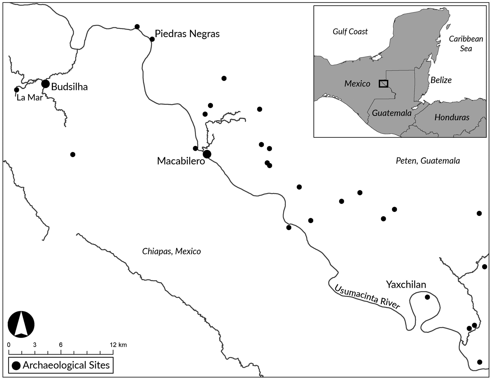
In this study, we report on deposits of spherical stones from two sites—Macabilero and Budsilha—in the Usumacinta River region of Guatemala and Mexico (Figure 1). This area has been the subject of ongoing investigations by the Proyecto Arqueológico Busiljá-Chocoljá (Mexico) and the Proyecto Paisaje Piedras Negras-Yaxchilan (Guatemala), directed by Scherer and Golden, with Urquizú in Guatemala. Recinos is the project lithicist on these projects and directed research at Budsilha during the field season in which the spheres presented here were found. For their part, Alcover Firpi and Rodas led research at Macabilero.
Map showing the location of Macabilero, Guatemala and Budsilha, Mexico. Map by Alcover Firpi.

The Usumacinta River Valley is formed by the confluence of the Pasión and Chixoy rivers in Guatemala, as well as the Lacantún River in Mexico. This region is not only unique because of its broken, karstic topography, but also for its settlement history, which deviates from contemporary regions in the central Peten. The earliest documented settlements in the Usumacinta River Valley start around 800 to 500 b.c. (Dobereiner Reference Dobereiner2016; Golden and Scherer Reference Golden and Scherer2013; Golden et al. Reference Golden, Scherer, René Muñoz and Vasquez2008:258, Reference Golden, Scherer, Houston, Schroder, Morell-Hart, Álvarez, Van Kollias, Talavera, Matsumoto, Dobereiner and Firpi2020; Houston et al. Reference Houston, Escobedo, Child, Golden, René Muñoz and Smith2003). In comparison with the contemporaneous settlements in the central Peten, such as at Tikal or El Mirador, these early settlements are neither large nor architecturally imposing. Similarly, they do not exhibit obvious defensive features, and site placement does not suggest a concern with defense. By the end of the Preclassic period, however, warfare became pervasive, forcing the development of small fortified centers (Golden et al. Reference Golden, Scherer, René Muñoz and Vasquez2008:252). The site of Macabilero is one such center and consists of a small civic ceremonial center perched atop a steep hill and circumscribed by walls and monumental terraces (Alcover Firpi Reference Alcover Firpi2020; Golden et al. Reference Golden, Scherer, René Muñoz and Vasquez2008:257).
The site of Macabilero was first documented by Shook and photographed by Satterthwaite in 1934. It was not until the year 2000 that researchers from the Proyecto Arqueológico Piedras Negras, sponsored by Brigham Young and the Universidad del Valle, created preliminary maps of the site's buildings, including multiple stone-lined terraces and platforms (Golden et al. Reference Golden, Vassaux, Parnell, Escobedo and Houston2001:518). In 2004, Luis Romero returned to the site to recover surface material as a means to evaluate Macabilero's initial occupation. After scrutinizing a collection of surface deposits in nearby caves, Romero suggested the site was initially settled during the Preclassic period. Alcover Firpi and Rodas (Reference Alcover Firpi, Rodas, Urquizú, Scherer and Golden2017:296) researched the main areas of the fortification to evaluate the site's chronology, as well as how and why its users developed a network of megalithic defensive structures (see also Alcover Firpi and Rodas Reference Alcover Firpi, Rodas, Firpi and Urquizú2018:11; Urquizú and Rodas Reference Urquizú, Rodas, Firpi and Urquizú2018:69–70).
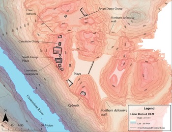
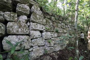
Macabilero can be best understood as a Late Preclassic (ca 300 b.c.–a.d. 350) fortified refuge, with its settlement dominated by large, multi-terraced platforms atop a hill overlooking the Usumacinta River (Figure 2). The site's architecture is characterized by the presence of large defensive terraces (Figure 3), that are built above a network of caves and surround an assemblage of small pyramids, extensive public plazas, and a series of range structures located across numerous interconnected hills. They are distinct features not only for the region, but for the greater Maya lowlands at this time. The highest of these terraces, for example, has a length of approximately 122 meters and ranges between three to seven meters in height (Alcover Firpi Reference Alcover Firpi2020:218). Although it was initially believed that the site was a Classic-period outlier of El Cayo, Mexico, we now know that the site was predominantly a Preclassic center (Golden et al. Reference Golden, Scherer and Muñoz2005a:13). With its extensive plazas, platforms, and cave networks, Macabilero was the locus of significant ritual activity. These observances were particularly true for the site's caves, where people left offerings, including ceramic vessels, as well the remains of human and animal sacrifices. Among the artifacts found within these caves is a human mandible with fractures consistent with decapitation by a stone axe, radiocarbon dated to a.d. 73–226 (Alcover Firpi and Rodas Reference Alcover Firpi, Rodas, Urquizú, Scherer and Golden2017; Scherer Reference Scherer2017:323–325). This mandible is roughly contemporary with the construction of the defensive terraces, providing circumstantial evidence for endemic violence in the area.
LiDAR derived map of Macabilero with groups and features labeled. Image rendered by Alcover Firpi using data collected by the 2019 joint mission of the PABC/NCALM.

Macabilero's defensive terraces. Photograph by Alcover Firpi.

Recent investigations by Alcover Firpi and Rodas (Reference Alcover Firpi, Rodas, Urquizú, Scherer and Golden2017) and Urquizú and Rodas (Reference Urquizú, Rodas, Firpi and Urquizú2018) uncovered new terraces, defensive walls, mounds, and a series of caves with deposits of limestone spherical stones. This research confirmed that the first stages of construction at the site included civic ceremonial structures and small plazas located on a defensible hill. However, at some point between 300 b.c. and a.d. 200 there was a burst of defensive construction. These structural changes improved the site's defensive capacities and comprised seven, new levels of megalithic terraces around the main group at the site, with a natural limestone escarpment defining the western side of the site-core (see Alcover Firpi Reference Alcover Firpi2020). A system of defensive walls was constructed to limit access to the site from the surrounding valleys. These walls resemble in shape and architectural style those documented at El Mirador and Nakum during the Middle Preclassic period (Hansen Reference Hansen and Houston1998:97). Along with the construction of these defensive features, Alcover Firpi and Rodas (Reference Alcover Firpi, Rodas, Firpi and Urquizú2018) identified hundreds of spherical stones across numerous contexts at the site. Although Macabilero may have been among the largest settlements in the Usumacinta River region during the Late Preclassic, it is likely not the earliest, for the occupants may have come from elsewhere in search of security. By a.d. 350, the sociopolitical experiment that brought together people for defense and control of the region around Macabilero had ended, and the site was abandoned, with its population moving either to nearby emergent capitals such as Piedras Negras or Yaxchilan, or to the smaller sajal-governed center of El Cayo (Houston Reference Houston, Inomata and Coben2006; Houston and Inomata Reference Houston and Inomata2009; Houston et al. Reference Houston, Escobedo, Child, Golden, René Muñoz and Smith2003; Inomata Reference Inomata2006a, Reference Inomata, Inomata and Coben2006b).
When royal dynasties were established around the Early Classic (a.d. 250–350) at Piedras Negras and Yaxchilan, much of the regional population moved to these centers. Golden et al. (Reference Golden, Scherer, René Muñoz and Vasquez2008:266; Scherer and Golden Reference Scherer, Golden, Scherer and Verano2014:63–64) argue that while people could have moved to the new capitals to participate in the “vibrant political, economic, and social communities,” it is possible that they were escaping conflict. During the late Early Classic and Late Classic periods (a.d. 550–900), warfare shaped the use and development of the nearby landscape for kingdoms in the Usumacinta River Valley. At this time, the political boundary between Piedras Negras and Yaxchilan was repopulated and “transformed into a contested border zone” (Golden et al. Reference Golden, Scherer, René Muñoz and Vasquez2008:252).
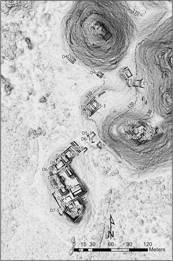
During the Classic period we document the rise of secondary nobles governing hinterland centers across the Usumacinta River Valley. Budsilha is among these secondary centers. The site was first reported by Maler (Reference Maler1903:91), and later mapped by members of the Proyecto Arqueológico Busiljá-Chocoljá in 2012 and 2013. The site of Budsilha is located near the Busilja River in Chiapas, Mexico, approximately 10 kilometers west of Piedras Negras (Figure 1). It is composed primarily of a palace and ancillary structures built atop a platform that rests on a naturally elevated area in a wetland surrounded by rural habitations (Figure 4). This settlement pattern is present at other sites, including Tecolote where Scherer and Golden (Reference Scherer and Golden2009:298) have argued that it served a special function as military post. Indeed, the settlement pattern suggests that the site was not merely a village—where the settlement distribution would be denser and more oriented towards agricultural production—and that the Budsilha inhabitants were concerned with maintaining visibility of their surrounding terrain (Scherer et al. Reference Scherer, Golden, Schroder, Pimentel, López, Scherer, Golden and Dobereiner2013b:59). Budsilha, however, cannot be considered explicitly as a defensive site because it lacks traditional fortifications found elsewhere.
Multidirectional hillshade derived from 0.5 m resolution Lidar data showing architectural center of Budsilha with structures labeled; 10 m contour intervals indicate meters above sea level. Image by Charles Golden, PABC.

Though no inscriptions have been linked to Budsilha, texts from La Mar, located four km west of Budsilha, together with monuments at Piedras Negras, identify a late ruler of La Mar as a subordinate to the Piedras Negras king. Indeed, inscriptions at Piedras Negras repeatedly name lords of La Mar as integral members of the court. Thus, even without direct textual evidence, the circumstantial evidence of Budsilha's location between Piedras Negras and La Mar strongly suggests its integration within the Piedras Negras kingdom during the Classic period (Houston Reference Houston2015; Martin and Grube Reference Martin and Grube2008:151; Scherer and Golden Reference Scherer and Golden2012:74; Zender Reference Zender and Stone2002).
The first excavations at Budsilha were done in 2011, when Golden et al. (Reference Golden, Scherer, Cab, Dobereiner, Golden and Scherer2011:57) conducted test pits in the plaza south of Structure D6–4. In 2013, Golden excavated a low masonry structure (D7–3) located southeast of the site's main architectural complex, which was unexpectedly associated with dense deposits of obsidian and identified as a likely workshop (Scherer et al. Reference Scherer, Golden, Schroder, Pimentel, López, Scherer, Golden and Dobereiner2013b:30–31). Roche Recinos (Reference Roche Recinos, Scherer and Golden2018:58) returned to excavate this structure and its surrounding patio to investigate the extent of this workshop, followed by lithic study of its contents. The excavations during the 2013 and 2018 field seasons at Budsilha's main group have yielded more than 20,000 obsidian pieces—all recovered from approximately a six-by-six m area, excavated to a depth of approximately one meter (Roche Recinos Reference Roche Recinos, Scherer and Golden2019:379–382).
The majority of the site was probably built during the Late Classic period. Although there seems to be evidence for a Preclassic occupation, no Preclassic period constructions have been identified. The most salient feature of this site is its obsidian workshop, making it one of the most copious, known nodes of production and exchange of this material for the region (Roche Recinos Reference Roche Recinos, Scherer and Golden2019; Scherer et al. Reference Scherer, Golden, Schroder, Pimentel, López, Scherer, Golden and Dobereiner2013b:28). Perhaps due to the economic prominence of Budsilha, or because of its specialization in stone tool working, both chert projectile points and layered calcite spherical objects were found in relatively high quantities compared to other regional sites.
The connection between this large workshop and the abundance of weapons probably related to local conflict and warfare. The militarization of the boundaries along the Usumacinta River may have been in part aimed at controlling trade in the region (Golden et al. Reference Golden, Scherer, René Muñoz and Hruby2012:16). In the case of Budsilha it appears especially true given that it seems to have been the major producer of obsidian blades for Piedras Negras. Furthermore, the abundance of this coveted material at Budsilha may have made it attractive to possible (but unattested) attack by the enemies of Piedras Negras; at the very least, this would explain the link between an easily defended site and the workshop within. As mentioned above, the site-core, including the obsidian workshop, is situated atop a low rise in a swamp that floods during part of the year, making it relatively difficult to access. Water levels may have been higher in antiquity, when the forest canopy was likely more intact than it is today, having been cleared for expansive cattle pasture (Scherer and Golden Reference Scherer and Golden2012:52).
Out of the chert artifacts from the five structures and two plazas excavated in the epicenter of Budsilha, 3.71 percent was categorized as bifacial projectile points or unifacial projectile points, 50.9 percent was categorized as debitage, including bifacial thinning flakes and undifferentiated flakes or chunks. The rest consisted of celtiform bifaces or broken segments of bifacial tools that could not be categorized by morphology. It seems that the majority of the chert industry at the site of Budsilha consists of bifacial tools, possibly projectile points. Unfortunately, chert from the 2013 excavations was not analyzed, yet, according to the excavation reports, it consists of a considerable amount of projectile points (Scherer et al. Reference Scherer, Golden, Schroder, Pimentel, López, Scherer, Golden and Dobereiner2013b:17–21).
MATERIALS: SPHERICAL STONES FROM MACABILERO AND BUDSILHA
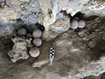
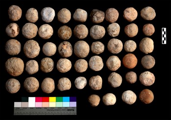
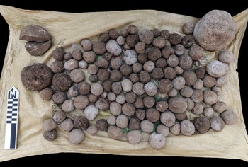
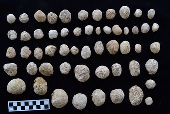
At Macabilero, 314 round stones were uncovered buried within structures B4-1, B4-2, B4-3, the Chango and Nameku caves (Figure 5), as well as the plaza in the Grupo Camaleón and the higher level of the terraces. In almost every single context within the walled portions of the site we documented rounded stones, with virtually none outside of the defensive spaces or at Grupo Sereque, which lies just north of Macabilero (Figure 6; Urquizú and Rodas Reference Urquizú, Rodas, Firpi and Urquizú2018). Some contexts contained as many as 123 round stones, others as few as 30. Although all 314 stones were photographically documented (Figure 7), only 200 were collected for further analysis.
Round stones found in Macabilero's cave systems. Photograph by Alcover Firpi.

Rounded stones from Operation 3B/3C at Macabilero. Photograph by Alcover Firpi.

Rounded stones documented at Macabilero. Photograph by Alcover Firpi.

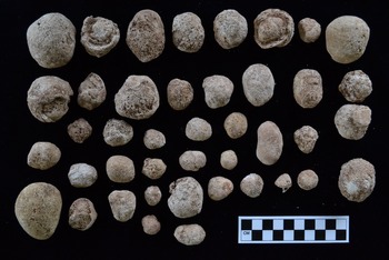
At Budsilha, spherical stones were found throughout excavations at the site's main structures and principal plazas. It has been suggested (Healy et al. Reference Healy, Emery and Wright1990:177) that these round stones might have been carried from the river along with other materials as a component of structural fill. But this proposal does not seem to be the case for Budsilha. Rather than even distribution in the plaza, there were instead small deposits of such stones (Figures 8 and 9). Excavations revealed at least two definite caches containing small piles of round stones. The latter of these had another possible cache 27 cm above it. The remaining round stones in the Budsilha assemblage were uncovered in various other contexts, ranging from one to five stones in number. Their disassociated state may suggest that they were not necessarily slingstones, or alternatively that they had become scattered after use. Our analysis on the inter-deposit statistics therefore focuses only on the three possible deposits (n = 109).
Rounded stones from Budsilha Unit 16–6. Photograph by Roche Recinos.

Rounded stones from Budsilha Unit 17–3. Photograph by Roche Recinos.

METHODS
The spherical stones from Macabilero and Budsilha were studied qualitatively and quantitatively. Qualitatively, we considered the location of stone deposits as well as evident signs of production, material, and burning. These attributes provide insights into how these objects were procured, modified, and used. Quantitatively, we measured the maximum diameter and weight of each stone with a digital caliper and digital scale. These measurements were taken in the project's laboratory after cleaning and processing. With these measurements in hand, we undertook statistical tests that examined variability within deposits, between deposits, and between the two sites. Analysis of variance (ANOVA) testing compares the statistical similarity of diameter and weight measurements between deposits to test their similarity relative to one another, with a post hoc Tukey's test to identify deposits with statistical differences. The results of these statistical tests, as well as more basic statistics of average diameters and weights, are then compared to slingstone studies elsewhere, especially in the Andes, where such weapons are reported in great numbers and in detail.
As a functional class of weapon, we would expect slingstones to be limited in their range of sizes and weights, with site-wide consistency of materials and perhaps some evidence of selection or modification. These characteristics are pertinent because they might be related to how they were used and for what purpose. At the same time, we do not expect slingstones at every site to look the same, neither in size, weight, nor material. As an ephemeral form of weaponry, their use would have depended on site layout and availability of resources. That is, we do not expect stones at Budsilha to be necessarily comparable to the stones found at Macabilero, especially given the different periods of their occupation and the differences in the environment. Based on ethnohistorical accounts from Mesoamerica and the Andes, we expect to find such stones in contexts associated with defense or otherwise indicative of warfare. A key factor in our analysis is context, thus we expect that this type of weaponry would be dependent on environment, resources, and location.
RESULTS
Macabilero
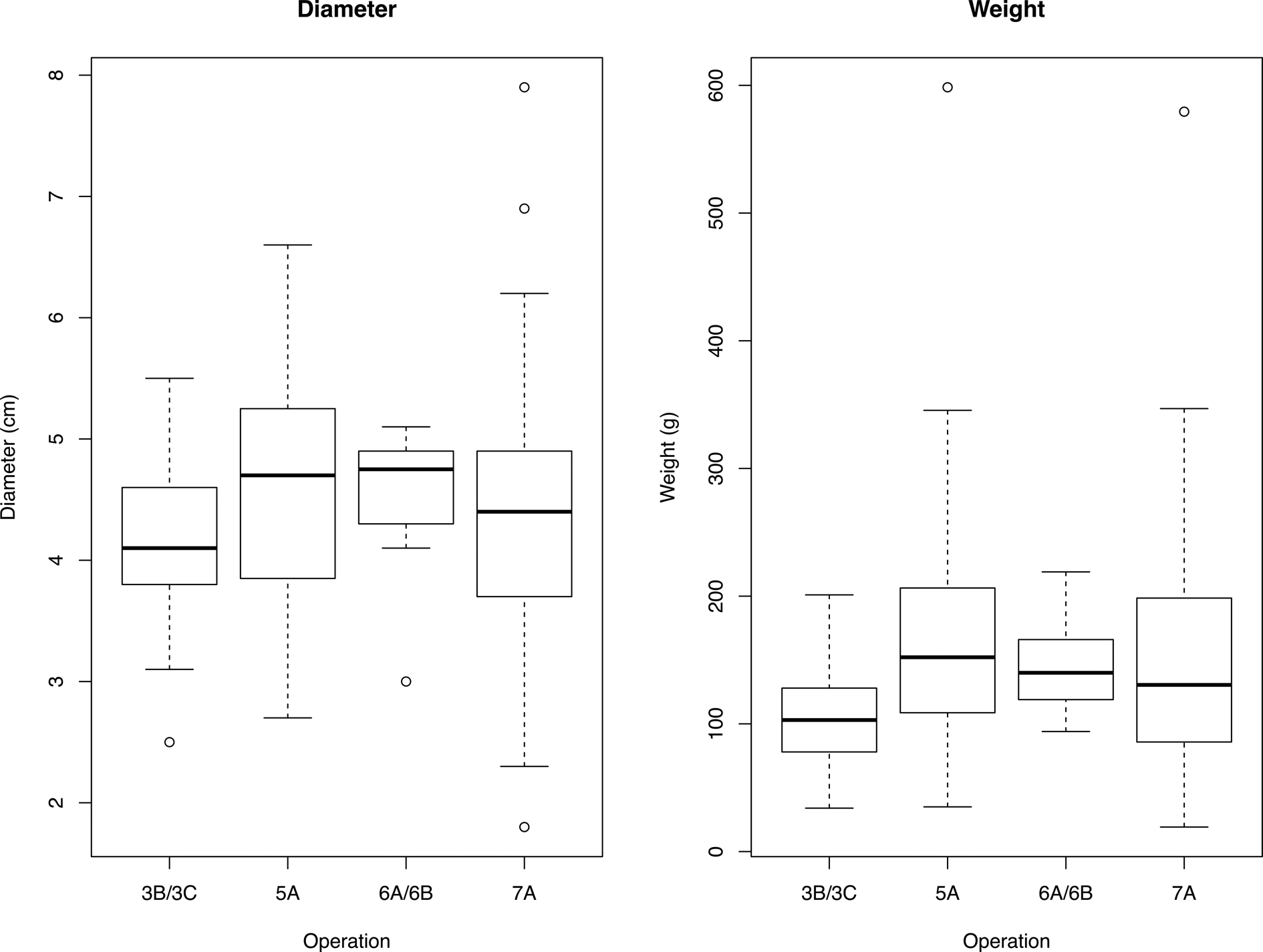
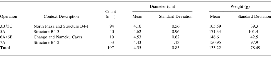
At Macabilero, spherical stones were located in structural fill, collapse, and the cave network located outside the site. Excluding this cave deposit, Operation 6A/6B, which is a sample of what is likely a much larger deposit, the other contexts show clear difference in quantity, ranging from 40 to 94 in number. The average diameters of these spheres are more consistent, falling around 4.35 cm, while their average weights, on the other hand, are more variable, ranging from about 105 g to 171 g. Figure 10 shows more clearly how the spherical stones from these contexts compare and the variance internal to each context. These patterns are quantified in the standard deviations presented in Table 1, revealing the relatively low internal variability of spherical stones from Operation 3B/3C (North Plaza and Structure B4-1) and 6A/6B (Cave), and the high internal variability in Operations 5A (Structure B4-3) and 7A (Structure B4-2). ANOVA tests show that there is a statistical difference between all four contexts relative to diameter (F (3,193) = 6.197, p = .02) and to weight (F (3,193) = 9.013, p < .001), which post hoc Tukey's test shows to be largely due to Operation 3B/3C (p = .02), which contains stones that are lighter and smaller.
Boxplot diagrams showing the distribution of diameter and weight values for Macabilero stones.

Descriptive statistics for spherical stones in Macabilero contexts.

Analysis of the total assemblage of stones (n = 197) shows that it has a normal distribution (Shapiro Test, p < .01), with an average of 132.22 g and a standard deviation of 78.49. Most of the assemblage (n = 159) falls within one standard deviation of the mean for weight. On the lower end there do not seem to be many outliers, with the lightest stone weighing 19.2 g but still being within two standard deviations of the mean (Z-score = –1.45). On the higher end, there are more outliers. Six stones fall above two standard deviations of the mean, of which two are more than five standard deviations (579.4 and 598.5 g, respectively).
As for diameter, the distribution of measurements likewise follows a normal distribution (Shapiro Test: p < .01), with an average of 4.35 cm and a standard deviation of 0.85. In weight, most of the assemblage (n = 151) falls within one standard deviation of the mean for diameter. Of the outliers, four fall below two standard deviations and six fall above two standard deviations. Both the weight and diameter measurements show a similar pattern, that is, the low variance within the dataset. Unsurprisingly, weight and diameter are well correlated, with an R 2 value of 0.70 and a p-value < .001.
The bedrock of the Usumacinta River Valley region is predominately limestone (as it is for all of the Maya lowlands), and this material is by far the most easily available lithic raw material (Bergoeing Reference Bergoeing2015:19). With the headwaters of its major tributaries located in the Guatemalan and Chiapas highlands, however, the Usumacinta River contains igneous and metamorphic stone pebbles and cobbles. At Macabilero, located above the banks of the Usumacinta River, inhabitants would have had easy access to such materials, but instead chose to work predominantly with limestone. Almost all stones are limestone (n = 189), except for eight which are river stones. Of the limestone stones, some appear to have been shaped in some way, such as being knapped or ground to acquire a round form. None of the stones presented any evidence of burning. The stones found in the structural fill deposits of Operation 7A, however, were clearly associated with other ritual activity, possibly bloodletting and sacrifice, for they were found alongside an imitation of a stingray spine and canid mandibles (Alcover Firpi and Rodas Reference Alcover Firpi, Rodas, Firpi and Urquizú2018).
Budsilha
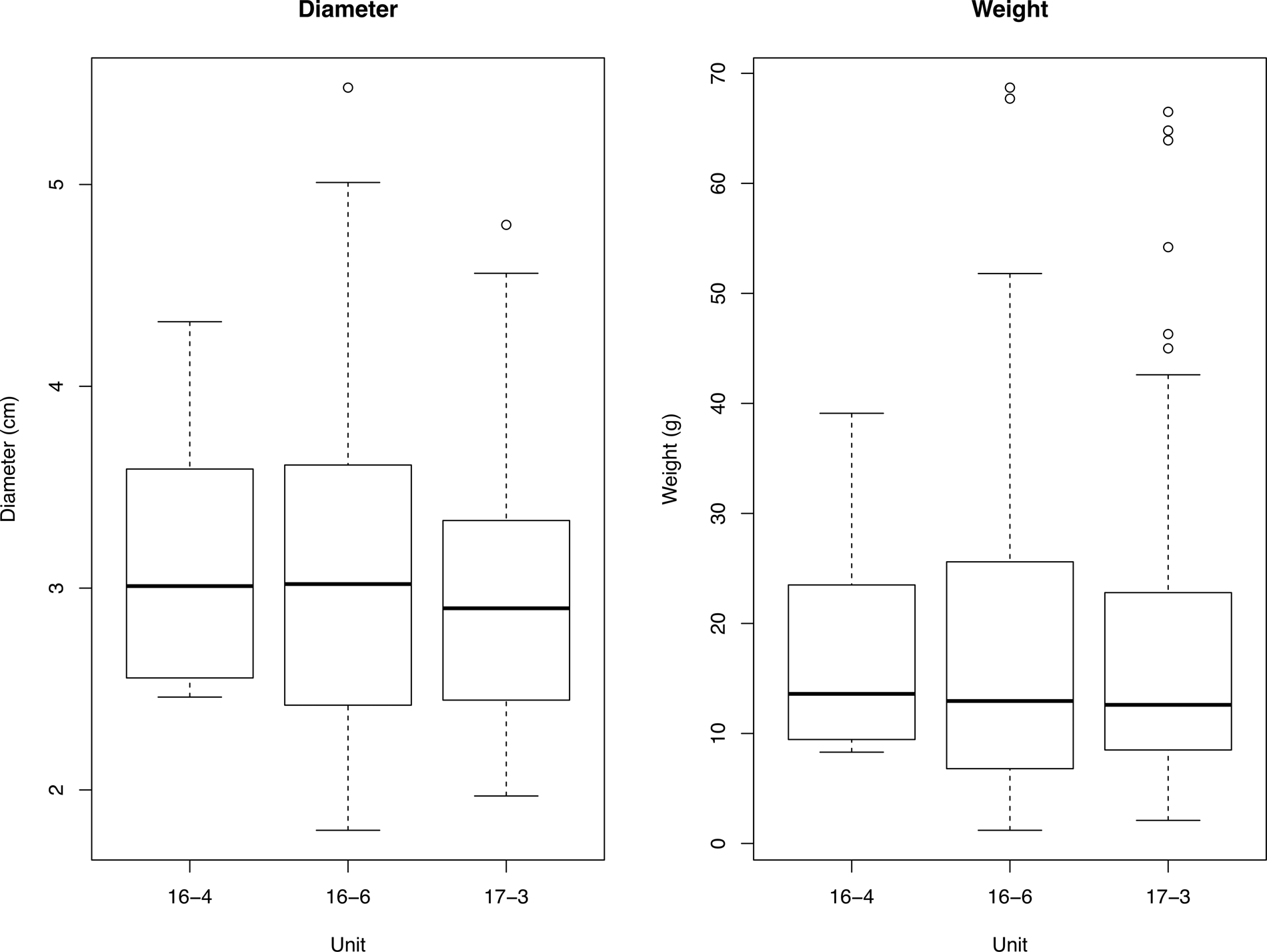
Three discrete deposits of round stones were recovered from Budsilha, all coming from excavations within the plaza area. Units 16-6 and 17-3 contain relatively similar quantities of stone, whereas Unit 16-4 contained markedly fewer stones (Roche Recinos Reference Roche Recinos, Scherer and Golden2018:62–64). Despite these differences, all three assemblages exhibited remarkable consistency in average diameter and weight measurements, clustering closely around the overall averages of 3.06 cm and 18.47 g. This consistency is demonstrated in boxplot diagrams for diameter and weight (Figure 11) that show little variability between caches; this distribution is seen in the standard deviations presented in Table 2. Where there are outliers, they are frequently on the upper ends of the distributions for both diameter and weight. ANOVA tests confirm that there are no statistical differences between these three caches relative to diameter (F (1,106) = 0.23, p = .74) or weight (F (1,106) = 0.03, p = .97).
Boxplot diagrams showing distribution of diameter and weight values for Budsilha stones.

Descriptive statistics for spherical stones in Budsilha contexts.

As to origin, the stones were likely formed in the Busilja River, which shows abundant accumulation of waterfall tufa along the smaller streams coming from the Busilja River. The eroding action of the flowing waterfalls allows for the dissolution of limestone and the precipitation of carbonate. In turn, lime crusts form around smaller stones, as well as the shells of jute snails (Pachychilus sp.) that are abundant in this waterway. In either case, the results are small spherical nodules composed of layers of calcite growth around either a smaller stone or shell. This phenomenon also has been observed at the Chechem Ha Falls, Belize (Gibson and Byerly Reference Gibson, Byerly, Engel and Hatcher2018:30). The majority of these stones are naturally round and do not seem to have been worked in any way. Yet, like river pebbles and cobbles, they do not occur naturally in the soils of the site of Budsilha and must have been intentionally brought to the site. Some of them (seven percent of the sample) display burn marks. This burning may indicate intentional heating, perhaps for hardening the stone, in relation to cooking, or as the result of garbage disposal. The absence of any other burnt material associated with these stones indicates that the burn marks are not from later taphonomic processes. Here as well, weight and diameter are well correlated, with an R 2 value of 0.822 and a p-value <.001.
DISCUSSION
Slingstones and other hurled stones were easy to obtain from natural sources, such as nearby river systems and could be rounded, as needed, with relatively simple grinding techniques. We argue that such accessibility meant they were likely widely used, being both a virtually unlimited resource and accessible to large segments of the population. Hurling stones by hand requires no training (though accuracy is not guaranteed) and the use of slings is an ability that is relatively easy to acquire in childhood, though real skill certainly would have taken much practice and specialized training would have been necessary to be able to effectively use this weapon in combat. We suggest that in part because of this ubiquity that, like so many quotidian aspects of ancient Maya life, depictions of hurled stones and slings are largely absent from Classic-period imagery. As a result, the collecting, caching, and use of hurled stones and slingstones by the ancient Maya have been largely overlooked.
Slingstones and hurled stones were likely used for a wide range of defensive purposes either within a large group or by individuals, possibly including women, children, and the elderly, many of whom became adept at using these projectiles through their use in non-warfare related activities such as hunting. As some scholars argue (Bancroft Reference Bancroft1874:627; Hassig Reference Hassig1992:29), slings have a high rate of fire and can be cast at great distances. Ethnographic and experimental data suggest a range between 50 and 80 m (Brown Vega and Craig Reference Brown Vega and Craig2009:1265–1266), making them a highly effective ranged weapon that would have probably required little additional training to use in a military context, beyond that already gained through hunting or other non-warfare activities. Such characteristics suggest their use in defensive contexts and by individuals guarding their territory or property, but additionally for hunting small game and birds or scaring away pests from crops. While this distinction between hunting and warfare may be relevant for addressing general questions about Maya warfare, it may not have been immediately relevant or clear for nonelite Maya who employed slingstones. Skills and experience gained in the service of hunting could have been easily employed for purposes of defense during times of warfare, with the same objects serving both purposes.
These observations, supported by ethnographic research, challenge the idea of warfare being fought only by elites with lances and arrows. Such elites likely would have used other weapons, depending on the scale and context of conflict, and warfare would have certainly incorporated nonelites, particularly in cases of defense. That we find projectile stones in a wide range of contexts and typologies reflects the diversity of ways in which conflict occurred and the segments of society that participated in it. The variability of projectile stones demonstrates their commonality and ubiquity, at times used for defensive purposes, at others for hunting, cooking implements, or ritual objects.
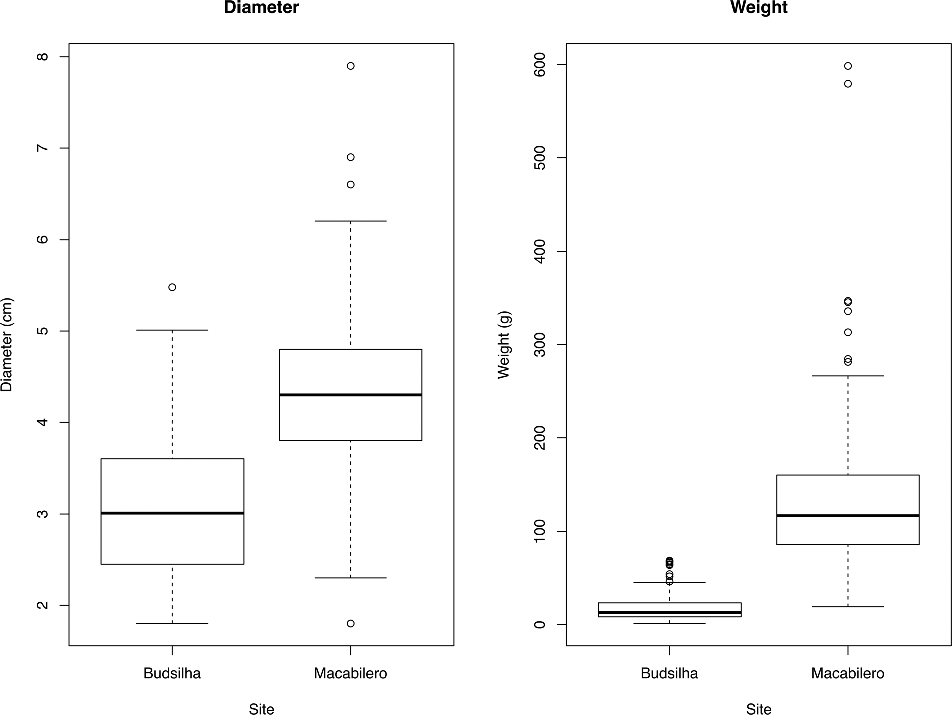
Our analyses of stones from both Macabilero and Budsilha show pronounced consistency within each site, demonstrating local preferences in the selection and manufacture of spherical stones. Yet, when we compare assemblages between sites, we find they reveal differences in size, material, and manufacture. The stones from Budsilha are, on average, 1.29 cm smaller in diameter than those from Macabilero, and with a difference in mean weight of 114.75 g (Figure 12). The notable difference in weight may reflect the difference in materials between the limestone slingstones at Macabilero and those formed by accumulations of calcite at Budsilha. Macabilero slingstones are made from mostly limestone, less commonly from river stones, and were mostly recovered in caves as well as inside the fill of structures and plazas within the fortified areas of the refuge. Budsilha's slingstones largely consist of naturally occurring spherical calcite river rocks from the Busilja River and were found in mostly caches at the site's main group plaza. T-tests for weight and diameter between the Macabilero and Budsilha assemblages show that these samples are statistically different (p < .001), which further underscores the variability in procurement strategies and resource availabilities of each site. A further point of contrast is the consistency of the stone deposits at Budsilha compared to Macabilero. While the overall standard deviation at Budsilha for weight is 15.49 g, at Macabilero the standard deviation is 78.49 g. These distinctions highlight the disparity in stone size between the two sites, with the stones at Budsilha not only lighter than those at Macabilero, but also more consistent in size across the site. That these stones were naturally procured makes this finding all the more surprising, showing perhaps a clear preference in selection criteria.
Boxplot diagrams showing distribution of diameter and weight values for Macabilero and Budsilha stones.

As for the quantity of stones found in each context, the apparent contrast in quantity cannot be explained by preservation conditions, and must instead be due to differences in use, taphonomy, or later interventions. The contexts in which they are found are also clearly relevant, as Operations 5A and 7A at Macabilero are within a building's fill, whereas Operation 3B/3C is below the plaza. Such contexts would not have made these deposits accessible in times of warfare, but it is possible that they were deposited during a brief period of relative peace when not immediately needed. Their use as building material shows both the commonality and ephemerality of these weapons. Likewise, the discovery of spherical stones beneath the plaza at Budsilha perhaps reflects their deposition as building material after a period of conflict and insecurity.
Altogether, the evidence presented here provides strong support for the identification of spherical stones at Macabilero and Budsilha as projectile stones during the Late Preclassic and Late Classic periods. Their intersite variability, low levels (if any) of modification, widespread distribution across each site, and reuse in other contexts all point to the essential commonality of these artifacts and the ease with which they can be utilized. In studying possible slingstones within the archaeological record, it is essential therefore to recognize the functional fluidity of this artifact category, at times being used for warfare, hunting, ritual, cooking, or construction material. In order to contextualize these results and interpretations and argue for a wider comparative study of projectile stones in the archaeological record, we frame our findings against evidence for the use of such weapons in Mesoamerica and the broader Americas. We argue that comparisons of this kind can help inform interpretations of our findings and studies of Maya warfare and hunting.
Implications for Maya Warfare
From the data at hand, it is reasonable to identify stone spheres within Maya defensive structures as early projectiles weapons. Indeed, during the Preclassic period, communities began constructing perimeter walls around unfortified settlements, or simply abandoned them in favor of more defensive spaces (Golden and Scherer Reference Golden and Scherer2013; Houston et al. Reference Houston, Stuart and Taube2006; Inomata Reference Inomata, Scherer and Verano2014; Inomata et al. Reference Inomata, Triadan and Aoyama2017; Rice and Rice Reference Rice and Rice1981; Scherer and Golden Reference Scherer and Golden2009; Webster Reference Webster1973). Defensive walls and ditches were raised at sites such as Becan (Webster Reference Webster1972, Reference Webster1976), Cival (Estrada-Belli Reference Estrada-Belli2011:52), El Mirador Basin (Acuña and Chiriboga Reference Acuña and Chiriboga2019; Hansen et al. Reference Hansen, Forsyth, Woods, Schreiner, Titmus, Kathryn Brown and Bey2018), La Cuernavilla (Canuto et al. Reference Canuto, Estrada-Belli, Garrison, Houston, Acuña, Kováč, Marken, Nondédéo, Auld-Thomas, Castanet, Chatelain, Chiriboga, Drápela, Lieskovský, Tokovinine, Velasquez, Fernández-Díaz and Shrestha2018; Houston et al. Reference Houston, Garrison and Alcover2019), Muralla de León (Rice and Rice Reference Rice and Rice1981), and Zancudero (Golden et al. Reference Golden, Scherer, René Muñoz and Vasquez2008). Defensive walls have also been found at the Late Preclassic site of Nixtun-Ch'ich’, on the western shores of Lake Peten Itza (Pugh et al. Reference Pugh, Rice, Nieto and Rice2016:3–4; Rice and Pugh Reference Rice and Pugh2017:13). Such evidence suggests warfare on a relatively local scale, with an emphasis on the defense of a single settlement or a portion of it prior to the formation, organization, and maintenance of a polity (Golden et al. Reference Golden, Scherer, René Muñoz and Vasquez2008:268).
Macabilero presents an especially compelling case study for Late Preclassic period projectile stone use in light of its expansive fortifications and hilltop location. The systematic production, as seen in the grounding evident on all the stones, indicates that the use of slingstones was widespread in this community. While members of the community may certainly have used their slings to hunt animals, the extensive caching of slingstones accords well with similar practices observed at hilltop forts in the Andes. Macabilero's walls and terraces are positioned in such a way that standing on the highest section a slinger could shoot to the bottom of the hill without injuring slingers in lower level terraces (Figure 3). We must note that there must have been some limitations to the use of slingstones in highly dense forested areas (but see Linton Reference Linton1933:242; York and York Reference York and York2011:17). Driver and Massey (Reference Driver and Massey1957:357) have argued that this reason was why slings and slingstones were scarcely used in eastern North America or the Caribbean. As York and York (Reference York and York2011:108) point out, however, the absence of sling-oriented studies in the area could have contributed to the idea that this type of weapon was less used or not used in these regions. To the west, projectile stones could have been used to disrupt river travel, since Macabilero's plazas provided clear views of the Usumacinta River to the west from the edge of the hill. When thrown to the river, these stones would have caused serious damage to people and their canoes. Macabilero is located at a crucial crossing point on the Usumacinta River, in a stretch of the river otherwise dominated by steep canyon walls and fast-moving rapids. Slingstones were likely employed to defend against attack and to bombard unwanted travelers on this stretch of the river, threatening cargo and human life. The use of slingstones to attack enemies in canoes is a strategy that was used by the Stólō of British Columbia's Fraser River Canyon, who used rounded stone balls of approximately 10 centimeters in diameter that were said to have been able to tear through enemy canoes (Duff Reference Duff1952:60; York and York Reference York and York2011:96).
Similar to ethnographically observed sling and slingshot use, hurled stones and slings were weapons that were reasonably used by broad segments of ancient Maya society. Nevertheless, we do not want to downplay the importance of practice in both hurling stones and the effort required to select, transport, and in some cases shape stone for throwing or sling use. At Budsilha, the stones were unshaped and readily available in the Busilja River. Nevertheless, as our statistical analyses show, occupants of the site were careful in selecting only a limited range of sizes and shapes, presumably those optimal for sling use. This preference was common in many regions of the Americas, such as Chankillo, Ostra, Hawaii, and Hawikuh where no modification is evident for slingstones (Ghezzi Reference Ghezzi, Isbell and Silverman2006; J. Topic Reference Topic, Tkaczuk and Vivian1989; York and York Reference York and York2011:56, 92).
At Macabilero, on the other hand, some crafting seems to have been employed. Just like any other skill, the practice of stone knapping was transmitted through a learning process that required the observation and imitation of the repetitive movements that were performed by an experienced knapper (Mauss Reference Mauss1973:73; Pelegrin and Roche Reference Pelegrin and Roche2017:177). The production of slingstones would not have required extensive knapping skills, however, at least not nearly as much as projectile points, darts, or lances. Slingstones could have been naturally rounded rocks or could have been pecked and/or ground to achieve an ovoid or spheroid shape, thus making them a readily accessible resource for Maya people during times of conflict. It is likely that during the process of creating the megalithic blocks for Macabilero's defensive terraces, the inhabitants cut some limestone fragments to fashion the spheres. While pecking and grinding would have required a substantial time input, it is easy to master (Lowe et al. Reference Lowe, Kramer, Wilson, Meindl, Spurlock and Eren2019:681). At other sites, such as the El Diablo group at El Zotz, users created slingstones by roughly pecking a round shape, but these lack the spheroid round shape of those at Macabilero. The same occurred at Ceibal, where hundreds of roughly shaped stones have been documented in Late Preclassic caches (Inomata et al. Reference Inomata, Triadan, Román, Ruiz, Ponce and de León2010:38–39). In other instances in the Americas, slingstones have been made using baked clay (Coe and Diehl Reference Coe and Diehl1980:287; Hassig Reference Hassig1992:28; Heizer Reference Heizer1937:41), making them one of the most easily attainable weapons.
CONCLUSIONS
This article has analyzed slingstone artifacts from two different sites in the Usumacinta River Valley region and in different periods. We document the variability of these artifacts, as intentionally modified stones and naturally collected river-cobbles. Projectile stones hurled by hand or sling were weapons used by all segments of Maya society. The absence of slings in the iconography of the Classic period suggests they were not part of a prestige class of weaponry, which included spears and atlatls. Their presence at these sites, particularly during periods of warfare and interpolity conflict when defensive structures appear, provides insights into the contexts in which conflict occurred and the anxiety felt by Maya people who mobilized communities to plan their defense. The potential use of these weapons by Maya elite and commoners expands our perspective on Maya warfare beyond iconographic depictions and brings into discussion a larger range of people engaged in warfare and defense.
That such defense was local and arising from particular periods of danger is seen in the intersite variability between slingstone assemblages. That is, there is no one typology that defines a Maya slingstone and the identification of such artifacts in the archaeological record must depend on knowledge of the site and its surrounding resources, as well as a sufficiently large assemblage of possible slingstones. Slingstones from Mesoamerica and South America ranged from two to six centimeters in diameter with a weight of 25 to 325 grams, but clustered around 25 to 50 grams (York and York Reference York and York2011:79; see also Hassig Reference Hassig1988:80, Reference Hassig1992:28–31; Nadaillac Reference Nadaillac and D'Avers1884:279). Both of our samples fall within this range, but there is pronounced variability between them regarding material, size, and weight. Where they were stored differed as well. The Macabilero samples were stashed in caves and apparently later used as construction fill, while the Budsilha samples were primarily found in the plaza area. Nevertheless, their collection and placement were clearly intentional, reflecting local concerns and needs of the community at that time.
These statistics demonstrate the value of studying these artifacts as assemblages. The outliers according to weight and diameter may in fact not be slingstones, or at least warrant different interpretations. When studied alone, these differences are not as notable. Thus, while intersite and cross-cultural comparisons are useful and informative for understanding slingstone collection and use, such comparisons highlight diversity rather than uniformity. We recommend studying slingstones as assemblages and considering the context of the site and site resources. Slingstones come in various shapes and sizes, from naturally occurring rocks, to carefully pecked and ground stones to even baked clay. It is necessary to exercise caution when labeling them as solely ritual or divination artifacts and recognize their utility as a readily available weapon or hunting implement. Increasing our understanding and data of this common weapon will provide useful insights into the life of everyday Maya people and their ingenuity during times of conflict. Warfare was not fought by only elites.
RESUMEN
En este artículo presentamos evidencia del uso de piedras de honda y otras piedras utilizadas para arrojar entre los antiguos Mayas de la región del Río Usumacinta. Las piedras redondas son frecuentemente encontradas en los sitios arqueológicos Mayas y han sido interpretadas de varias formas, incluyendo como herramientas de talla o cocina, artefactos rituales o de adivinación y en menor frecuencia como armas. Aquí proveemos nueva evidencia para la identificación de piedras redondas como armas basándonos en su morfología y en su contexto de excavación. Empleamos datos de los sitios de Macabilero, Guatemala y Budsilha, México que sugieren que las piedras redondas en estos sitios fueron manufacturadas para ser utilizadas como armas. Estos hallazgos tienen implicaciones en la forma en como entendemos la guerra y la caza en la antigua Mesoamérica e informan nuestras interpretaciones de cómo los Mayas se preparaban para dichas actividades. Como una clase de arma potencialmente accesible a la mayoría de los miembros de la sociedad Maya, los resultados presentados acá muestran la importancia de una perspectiva más inclusiva en temas como la guerra entre los Mayas y la necesidad de contextualizar los análisis de artefactos dentro de la historia de ocupación del sitio y la región en general.
ACKNOWLEDGMENTS
The Proyecto Paisaje Piedras Negras-Yaxchilan and the Proyecto Arqueológico Busiljá-Chocoljá conduct research under a permit held from the Dirección General del Patrimonio Cultural y Natural of the Instituto de Antropología e Historia (IDAEH) and the Consejo de Arqueología of the Instituto Nacional de Antropología e Historia (INAH), respectively. We are grateful for local permission and collaborations within the town of La Técnica in Guatemala and Nueva Esperanza in Mexico that make this research possible. We also want to thank the directors and codirectors Andrew Scherer, Charles Golden, and Mónica Urquizú. Special thanks to Andrew Scherer, Stephen Houston, Charles Golden, and Daniel Plekhov for their helpful comments on earlier versions of this paper. We would also like to thank Don Feliciano Sandoval who graciously talked with us about slingstones used in his hometown. Finally, we would like to thank the four anonymous reviewers for their extremely helpful and insightful comments and suggestions to improve our paper. These investigations have been generously supported by the Alphawood Foundation of Chicago and NSF Senior Research Grant, Archaeology Program (BCS-1505483/1505399), in addition to grants from Brandeis University, Brown University, the Wenner-Gren Foundation (Gr. 9764), NSF DDIG (BCS-1733551), and Fulbright IIE/U.S. Lidar data for Macabilero, Budsilha, and surrounding areas were collected during the 2019 joint mission of the Proyecto Arqueológico Busiljá-Chocoljá (PABC)/National Center Airborne Lidar Mapping (NCALM) with the permission of the Instituto Nacional de Antropología e Historia (INAH) in Mexico and the Instituto de Antropología e Historia (IDAEH) in Guatemala. Support for that mission came from grants from the National Science Foundation (BCS-1917671; co-PIs Charles Golden, Andrew Scherer, Timothy Murtha), Social Sciences and Humanities Research Council of Canada (435-2019-0837; PI Shanti Morell-Hart), and the Alphawood Foundation (co-PIs Charles Golden and Andrew Scherer).