CUMBRIA
(1) Low Side Quarter: three additional silver denarii: Galba (a.d. 68–9), 1; Trajan (a.d. 98–117), 1; Sabina (a.d. 128–38), 1. Total now stands at 30 denarii to a.d. 161.Footnote 61
(2) Maryport (?Alauna), Camp Farm (NY 041 373): work continued on the area of the classical temple identified in 2014.Footnote 62 A small rectangular post-built structure was found to the west of and respecting the temple. The circular building to the west of the temple was fully excavated, and found to be 10.64 m in diameter. The entrance was on the north side and was provided with a timber porch. At regular intervals around the circuit were four buttresses or pilaster bases. To the north of the buildings was a large open space with some traces of metalling. To the west of this space was a possible monument base. It was 2 m square and featured square projections in the centre of each side. The foundation was 0.90 m deep and comprised layers of clay and cobbles. To the south of the buildings was a complex multi-phase series of ditches. It is likely that the first two phases were boundary ditches to the temple precinct.Footnote 63
COUNTY DURHAM
(1) Binchester (Vinovia) (NZ 2102 3134): a sixth season of work in the new programme of excavation took place in 2014.Footnote 64 At the east corner of the fort the full width of the curtain wall (2.4 m) was exposed along with the walls of the angle-tower. A section through the south-eastern defences revealed the remains of the rampart of the original, Flavian, fort overlain by additional material added when the second fort was constructed c. a.d. 158. Here, the rear face of the fort wall is of inferior construction to the finely dressed masonry exposed on the north-east defences last year and may belong to a later rebuild. Continued excavation of the neighbouring cavalry barrack revealed further details of successive phases with internal timber partitions.
In the area beside Dere Street south-east of the fort, the remains of a third modestly sized strip-building were uncovered. This lay south of the two already uncovered and was the most crudely constructed and smallest of the three, being only c. 6 by 4 m in size. Removal of the fill of a post-Roman pit to the rear of this revealed the face of an earlier, neatly constructed wall possibly associated with the bath-building lying to the south — perhaps the outer wall of a palaestra.
Further work on the bath-building, where the majority of walls still stand to a height of c. 2.1 m above floor level, saw the removal of the entirety of the refuse deposits used to fill up the possible apodyterium to ground level following the building's abandonment. This revealed a stone bench around the edge of the room which obscured traces of an earlier plunge-bath at the side of the room next to Dere Street. Prior to the construction of the stone bench an additional chamber housing a plunge-bath or cistern had been constructed which protruded into the east end of the apodyterium. The wall facing out onto Dere Street incorporates two large splayed window embrasures. At a late stage in the development of the building the northern one had had its sill removed to allow the insertion of a short flight of steps forming a new access from the exterior protected by a small porch-like structure added at the same time. By this stage in the building's history the external ground level, because of successive resurfacings and rebuildings of neighbouring structures, had risen to c. 1.2 m above the internal floor level of the baths.
Entering the adjacent corridor and turning left would have given access to a circular laconicum excavated in the 1870s.Footnote 65 At the other end of the corridor a doorway afforded access to a suite of bathing chambers lying to the south. Excavation of a small portion of the first chamber belonging to the latter indicates, once again, walls surviving up to and including the base of window embrasures and extensive preservation of painted wall decoration.
An extension at the Dere Street end of the corridor provided two additional chambers of very modest size; that to the south containing a small plunge-bath and its counterpart opposite probably housing a free-standing pedestal wash-basin or labrum. A seventh and final season is planned for 2015.
NORTH YORKSHIRE
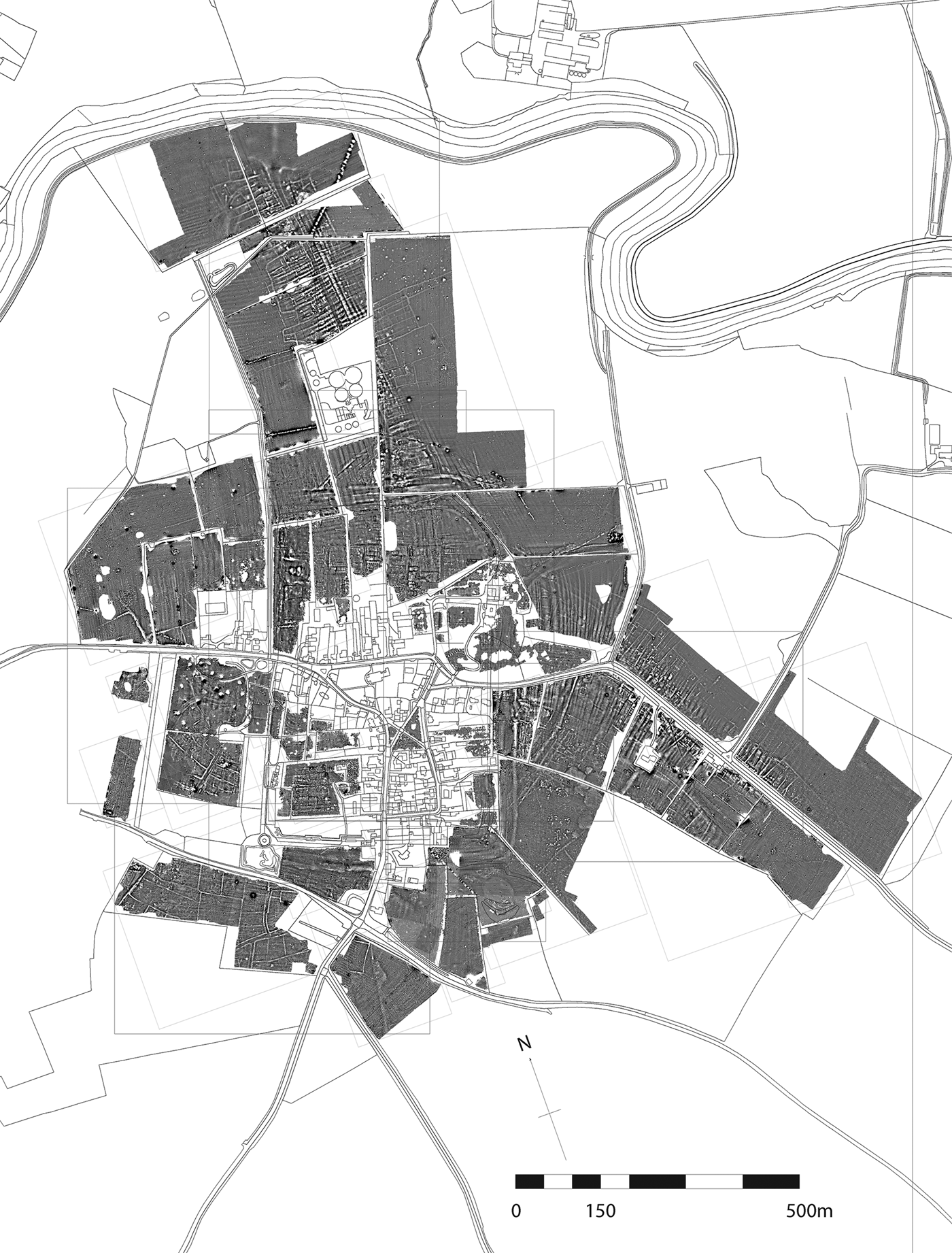
(1) Aldborough (Isurium Brigantum) (SE 4060 6632): a further season of the programme of non-invasive fieldwork initiated in 2009 involved the completion of the magnetometer survey of the extramural areas to the north, east and south of the town (fig. 7).Footnote 66 Work outside the west gate is continuing.Footnote 67 The results from all areas show further unexpected and impressive features, especially in the areas outside the south and east gates.
Aldborough. Overall plot of the magnetometer results.
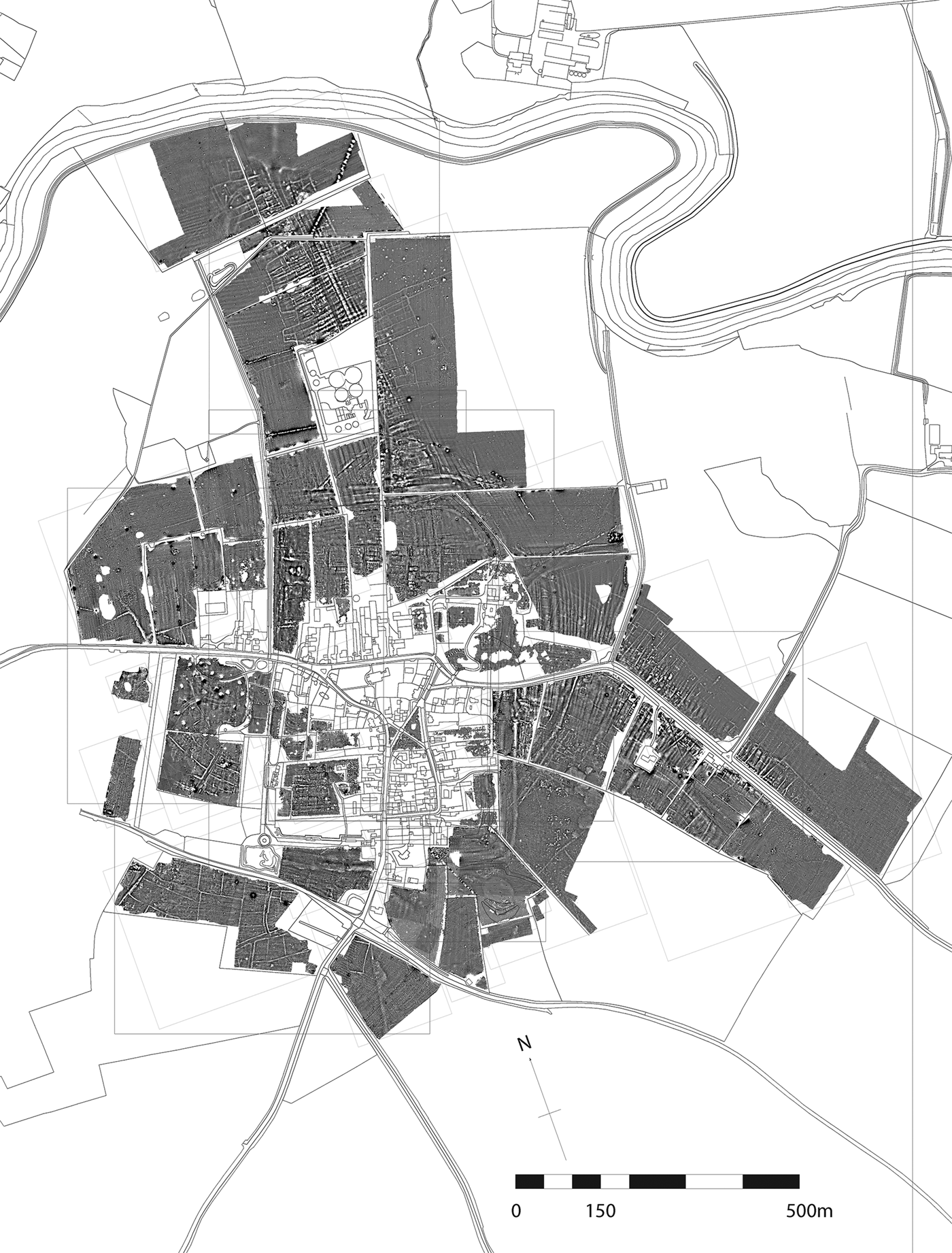
To the north of the town the area surveyed lay to the west of that covered in 2013, and completed coverage of the potentially accessible areas that lie above flood level (with the exception of a single field that lies within the curtilage of the sewage works). This revealed the back edges of the enclosures facing onto the Roman road as it approaches the bridge over the river Ure. Nearest the river there it also provided further evidence for a trackway running south-westward up the river valley. This opens out into a funnel onto the flood plain, and presumably formed a droveway. Further south there is also evidence for field boundaries to the rear of the settlement enclosures.
To the east, the area to the south-east of that completed in 2013 was explored, defining the extent of activity flanking the Roman road to York. To the north-east of the Roman road the regular series of enclosures facing the road continued for a further 100 m or so, before merging into field-systems. A single possible mausoleum was noted in this area, but most of the evidence suggests settlement and agricultural functions. In contrast, a complex series of features was recorded on the south-western side of the road. This appears to comprise the continuation from the north of the sequence of major funerary monuments facing onto the road. Behind this there is a complex of fields and other enclosures that continue up the slope to the west. There is possible evidence for a large but bounded open space between these two areas.
In the area outside the south gate the topography has also been shown to be quite complex. The expected route of the Roman road heading to the south or south-west is not immediately obvious. Immediately to the south of the modern crossroads, on the brow of the hill, the survey revealed part of a large rectangular compound. To its east a linear feature approaching the gate, and touching its north-east corner, is probably a boundary. To the north-west of the modern road, in the field around the village cemetery, the survey has revealed a network of trackways and enclosures which are apparently agricultural. A track defined by flanking ditches runs east–west aligned on the outer edge of the town defences outside the south gate. This may represent a Roman road which approaches the town along the Ure valley. Two further trackways intersect with it. One approaching from the north connects directly with the Roman quarry that lies immediately outside the north-west corner of the Roman town defences. The other, running south-west probably connects with that previously recorded a little further south.Footnote 68 At the north-western extreme of the area a boundary running ENE–WSW appears to continue the line of the trackway previously recorded approaching the west gate. The layout of the enclosures in this part of the landscape is complex, but it should prove possible to provide some phasing when alignments across the broader landscape have been further analysed.
A large area was surveyed to the west of the town, outside the west gate. A historic planFootnote 69 shows the location of the north side of this gate in a position a little to the north of that previously assumed. The area of the magnetometer survey to the north shows that the ditches around the north-west corner of the town are probably masked by alluvium. Further south, on the higher ground which flanks the northern side of the modern road there is evidence for a series of enclosures, the northern parts of which were recorded. These are aligned east–west, suggesting that the Roman road probably turned in this direction as it exited from the town. Re-examination of the geophysics previously undertaken to the south of the modern road perhaps confirms this, but a little further work in areas to the west is required to clarify this.Footnote 70
EAST RIDING OF YORKSHIRE
(1) Near Elloughton:Footnote 71 following the discovery in 2003 of this site near the river Humber by Mr A. McManus, in 2007 and 2009 the East Riding Archaeological Society (ERAS) carried out a resistivity and fieldwalking survey of approximately 4.3 ha revealing a hitherto unknown extensive pattern of Roman enclosures and buildings associated with a possible Roman road heading for the river Humber. A magnetometer surveyFootnote 72 in 2013 confirmed the presence of extensive buildings, some apparently elaborate with apses and almost certainly hypocausts and other features. One rectilinear building appeared to be a small temple or shrine.
Material from the ploughsoil included Iron Age coins, a stamped ceramic tile of Legio VI Victrix, tesserae, box-flue tile, worked stone, a ceramic oil-lamp, and Roman coins dating from the first to the early fifth centuries. Other finds included copper-alloy religious figurines, fragments of copper-alloy sculpture and a range of brooches. Later finds which included Anglo-Saxons brooches, strap-ends and coins and Viking Age items demonstrate continued activity.
Three trenches, A, B and C, each around 10 to 12 m in length and 2 to 3 m wide, were excavated to ‘ground truth’ the results of the survey work.Footnote 73 In Trench A a rectangular building around 20 m in length and over 7 m wide, visible in the geophysics and aligned roughly north–south, with an apsidal southern end, was shown to be badly plough-damaged but to survive at footings level and to be subdivided by an internal east–west wall. The width of the foundations showed that the building could have had two storeys. The presence of small tesserae suggested the former existence of a figured mosaic floor. The tesserae, along with red, pink and blue painted wall-plaster, suggest a building of some status. The building overlay a ditch containing third-century material. A paucity of later fourth-century material suggests that the building may have had a limited life.
Near the southern end of Trench B a gravel strip proved to be a wall footing and immediately to the south of it was another ditch. The bulk of the pottery from Trench B dated to the third century. Human bone was discovered during machine-stripping at the north end of Trench B; some remaining in situ demonstrated the presence of a badly damaged, probably male burial.
Trench C confirmed the presence of a ditch seen in the geophysical survey, which was shown to be over 1.5 m deep, 2 m wide and wet at the bottom. The ditch fills contained a large amount of animal bone, including cattle, sheep and pig. Much pottery was also found and at the very bottom was the greater part of a small wheel-thrown carinated bowl in a good quality greyware, probably from the pottery kilns around Throlam, Holme-on-Spalding Moor. The eyebrow of a facepot in a grey fabric was also found.
The few sherds of samian recovered in the excavation provided some evidence of earlier activity. No structures have yet been excavated that may relate to the unusual brooch assemblage found by Mr McManus which included Pannonian types from the first century a.d. Nor were any features found which may relate to early medieval brooches and pins known from the site.Footnote 74
(2) Fangfoss: a fused lump of base silver denarii, at least seven coins — possibly burnt as they are deformed into a fused mass (total wt = 14.01 g). Three of the coins can be identified as of Severus Alexander (a.d. 222–35) but further details are uncertain due to the condition of the coins.Footnote 75
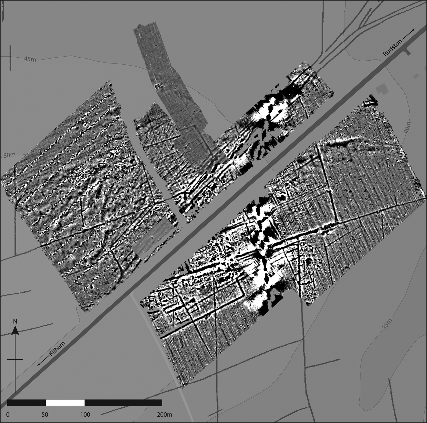
(3) Rudston villa (TA 0860 6660): a gradiometer survey covering c. 11.7 ha was undertaken of the villa and its immediate environs (fig. 8).Footnote 76 The survey covered the area of the villa previously excavatedFootnote 77 and the surroundings to the north, east and south. The extensive area covered facilitated the aim of assessing the relationship between the excavated villa and its broader landscape, connecting this with the work previously undertaken at Thwing.Footnote 78 The geophysical survey work was complemented by a study of recent aerial photographs of the same area.Footnote 79
Rudston. Overall plot of the gradiometer results.
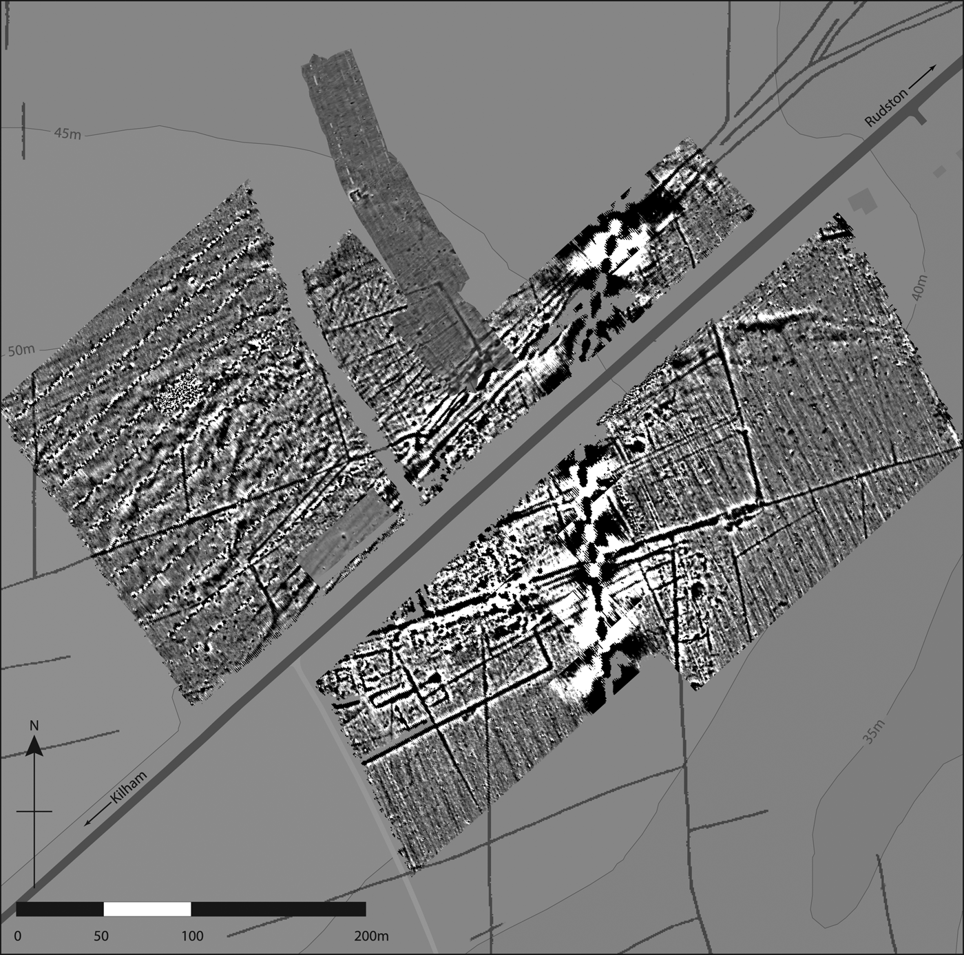
In summary the survey revealed three phases of Iron Age–Roman activity: (1) the trackway that runs south-west to north-east just to the north of the villa, linking the Wold top to the valley of the Gypsey Race. This seems to form part of a network of tracks linked to the dyke systems which divided the Wolds up in the later Bronze Age. It evidently continued in use throughout the period of use of the villa. (2) A series of boundaries on a WSW–ENE alignment that forms a continuation of a co-axial field-system noted in aerial photographs further to the north. The survey provides important information about this boundary system and a series of subdivisions now identified, in two respects. First, it links them with the excavated features beneath the villa which date to the period down to the second century a.d. Second, it reveals that they are later than the Phase 1 trackway in that one ditch curves to join it. This shows that the large-scale sub-division of the landscape in the area between Rudston and Thwing is of late Iron Age or early Roman date, and this has significant implications for our understanding of land-holding in this period. (3) A series of enclosures, trackways and boundaries in the immediate vicinity of the villa which have a slightly different alignment and are contemporaneous with the main phase of the villa. These provide important new details about the site, in particular showing how a new formal approach was created that manipulated the landscape context in a way closely comparable to that seen at Thwing.Footnote 80
(4) Spaldington: 14 clipped silver siliquae: a.d. 379–388, 2 (uncertain mint); a.d. 388–395, 1 (Milan); a.d. 395–402, 6 (Milan); a.d. 388–402, 5 (uncertain mint).Footnote 81
(5) Wold Newton: 1 radiate and 1,856 large module nummi. Radiate: Claudius II (a.d. 268–70), 1. Nummi: First Tetrarchy (a.d. 294–305), 1,622 (London, 298; Trier, 847; Lyon, 262; Ticinum, 80; Aquileia, 10; Rome, 57; Carthage, 34; Siscia, 6; Thessalonica, 1; Cyzicus, 1; Antioch, 6; Alexandria, 1; uncertain, 7; irregular copies, 12); Second Tetrarchy (a.d. 305–7) full weight module, 124 (London, 105; Trier, 11; Lyon, 7; Ticinum, 1); first weight reduction of a.d. 307, 48 (London, 39; Trier, 6; Lyon, 3); second weight reduction of a.d. 307, 62 (London, 58; Trier, 4). Found in a nearly intact (except for the rim) fourth-century Crambeck greyware jar. Also a Crambeck dish and three grey-black coarse ware sherds (one used as the lid for the jar). Also found in the jar was a small spherical blue glass bead with a cylindrical perforation.Footnote 82
BRADFORD
(1) Riddlesden: 110 silver denarii: Domitian Caesar (a.d. 69–79), 1; Trajan (a.d. 98–117), 3; Hadrian (a.d. 117–38), 5; Antoninus Pius (a.d. 138–61), 5; Diva Faustina I, 2; Faustina II, 1; Marcus Aurelius (a.d. 161–80), 7; Lucius Verus (a.d. 161–9), 2; Faustina II, 1; Commodus (a.d. 180–92), 4; Divus Antoninus, 1; Septimius Severus (Wars of the Succession, a.d. 193–8), 2; Septimius Severus (Joint reign of Severus and Caracalla, a.d. 198–209), 13; Caracalla, 9; Julia Domna, 5; Geta Caesar, 8; Plautilla, 3; Septimius Severus (Joint reign of Severus and Caracalla or of Severus, Caracalla and Geta, a.d. 198–211), 1; Septimius Severus (Joint reign of Severus, Caracalla and Geta, a.d. 209–11), 2; Geta, 1; Caracalla (a.d. 211–17), 7; Julia Domna, 2; Elagabalus (a.d. 218–22), 4; Julia Maesa, 2; Severus Alexander (a.d. 222–35), 7; Julia Mamaea, 1; Maximinus I (a.d. 235–38), 2; Uncertain emperor/ress, 9.Footnote 83 The coins might possibly be remnants of an antiquarian discovery reported from the same general area: the Bingley (Elam) Hoard.Footnote 84
WAKEFIELD
(1) Wakefield, City Fields (SE 3446 2243): evaluation identified a Romano-British agricultural landscape with small localised areas of possible settlement. A minimum of two ditched enclosures with possible internal divisions, droveways and field boundaries were identified, along with a small assemblage of pottery.Footnote 85
DONCASTER
(1) Doncaster, Rossington inland port (SK 5918 9877): results of a further evaluation suggest that the previously detected field-system, associated with a small Romano-British settlement, continues to the south. The field-system appears to have been confined to a gravel bank which will have afforded free-draining soils in a predominantly flat and wet landscape. The site had been heavily truncated by ploughing.Footnote 86
(2) Doncaster, 44–46 Warning Tongue Lane (SE 6315 0011): archaeological investigations were undertaken on land adjacent to a visible earthwork forming part of the Rossington Bridge pottery kiln site.Footnote 87 It is believed that the earthwork may relate to activity along the postulated route of Ermine Street between Lindum Colonia (Lincoln) and Danum (Doncaster). The absence of any archaeological features, deposits or artefacts indicates that the activity either did not extend into this area or that the evidence was removed as a result of disturbance.Footnote 88
LANCASHIRE
(1) Clifton: a small Magnentian hoard of 16 base metal nummi, mainly corroded and fragmentary: Constantinian (a.d. 335–40), 1; Constantinian, FTR, hut, galley (a.d. 348–50), 3; Magnentius (a.d. 350–3), 5; Decentius, 3; Uncertain Magnentius or Decentius, 4. The coins were found with a complete cast copper-alloy Roman bracelet.Footnote 89
(2) Dolphinholme: three silver denarii struck 131–64 b.c.Footnote 90
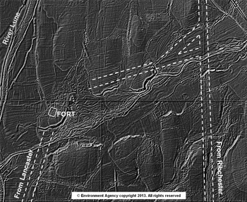
(3) Garstang, Walton-le-Dale–Lancaster Roman road (Margary 70d) (SD 5060 4150–SD 4841 4839): this presumed route has produced little hard evidence,Footnote 91 although a length of road was noted several years ago by P. Iles on an aerial photograph near Stanzaker Hall and when a pipe-line was excavated across it, an undated cobbled structure with ditches was found. Lidar has revealed that it was part of an impressive length of straight road of Roman characteristics (fig. 9). Projecting this line south, there is another possible Lidar indication (SD 5130 3933) so the route can be inferred with reasonable confidence perhaps as far as Barton — approximately 300 to 400 m east of the A6. Northwards, through Garstang there are some more Lidar indications (SD 4945 4510) and the road probably crossed the river Wyre near the High Street car park. It then more than likely coincides with the main road to Cabus Clay Lane Head before a slight turn via Fowler Hill Lane to Cabus Cross Roads where the Lidar evidence runs out (SD 4841 4839). It has not been found with certainty until north of Galgate where the known route over Burrow Heights, approaching Lancaster, shows up extremely prominently in the Lidar imagery.Footnote 92
Walton-le-Dale to Lancaster Roman road. Lidar image showing the Roman road west of the A6 near Stanzaker Hall (SD 506 415). (© The Environment Agency – all rights reserved)

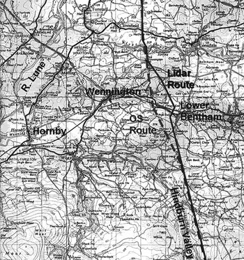
(4) Hindburn valley,Ribchester–Burrow-with-Burrow Roman road (Margary 7c) (SD 6466 6724–SD 6324 7199): the line of this road was thought to be known in its entirety; however, Lidar has shown this not to be the case for the stretch from the Hindburn valley to the river Greta (fig. 10). The accepted route has the road leaving the Hindburn valley, taking a dogleg to the north-west under Robert Hall and then following a course on or near to the county boundary between the river Wenning and river Greta.Footnote 93
Ribchester to Burrow-with-Burrow Roman road. The new route from the Hindburn valley to just north of the river Greta.

Lidar imagery demonstrates that there is no evidence to support the postulated route via Robert Hall but there is very clear evidence for the alignment from the Hindburn valley continuing straight on, almost to the river Wenning (SD 6466 6724–6437 6873). The agger is visible on the ground where it descends to Mewith Lane (SD 6454 6787). It has to curve slightly to drop down to the Wenning (SD 6420 6930).Footnote 94 On the other side of the Wenning (SD 6430 6950), across modern playing fields, there is a well-engineered climb from the valley bottom.
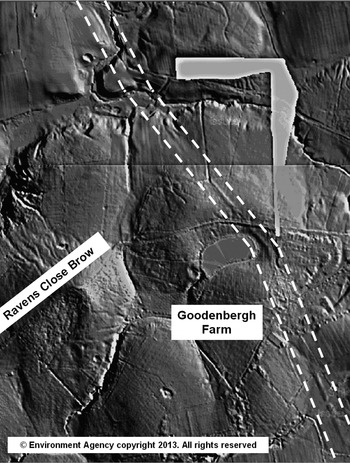
The Lidar then confirms this route (now in Yorkshire) heading for the river Greta just west of Brown's Farm (SD 6327 7167) (fig. 11). Approaching the Wenning the new route returns to be close to the OS line, but Lidar and an aerial photo show the road turning upstream to cross the river contra Margary.Footnote 95 Back in Lancashire the road ascends Windy Bank (SD 6324 7199) in a north-westerly direction before turning back to the north onto the accepted line.Footnote 96
Burrow-with-Burrow. Lidar image of the route between the river Wenning and the river Greta. The road across the middle of the image is Ravens Close Brow, from Wennington. (© The Environment Agency – all rights reserved)

(5) Lancaster, Lancaster–Burrow-with-Burrow Roman road (Margary 705) (SD 4900 6248–SD 6019 7188): on the evidence of a milestone found in 1803, at Artle Beck, Caton,Footnote 97 the existence of this road was always deemed highly likely and Lidar has allowed most of the route to be identified with reasonable confidence. There is evidence of a Roman road leading from Crag Road over the Ridge and heading north of Old Parkside Farm in the direction of Caton (SD 4900 6248–SD 5149 6395) (fig. 12).Footnote 98 Continuing on just south of a modern pumping station (SD 5176 6392) there are two apparent alternative descents visible on the Lidar, this leaves the exact route open to debate or perhaps indicates there were route changes/alterations here over time.
Lancaster to Burrow-with-Burrow Roman road. Lidar image of the section from Crag Road, Lancaster (bottom left) to north of Old Parkside (top right). (© The Environment Agency – all rights reserved)

The Artle Beck milestone records a distance of 4 mp (mille passum) almost certainly from Lancaster. The new Lidar route is remarkably direct and is now a very good match to this distance.
Beyond the pumping station, the route follows a slightly different alignment south of Escowbeck House (SD 5247 6409) but beyond here, because of modern development, there is only sporadic evidence. However, there is some Lidar evidence that the road could have turned slightly to pass just upstream of the milestone and some more traces supporting this line are visible just east of St Paul's School (SD 5443 6459).
Beyond Caton Green, there are visible indications of an agger east of Rose Bank (SD 5590 6600), just south of the A683. At Farleton, possible Lidar traces are evident between Claughton Bridge and Toll Cottage (SD5749 6728), where the modern road diverges off to the north. The Roman road appears to take a drier southern course avoiding marshy ground here.
Approaching Melling, Lidar suggests a possible course north of the modern road near Lune View Garage (SD 5935 7072). Beyond Melling, there are traces of an agger east of the A683 opposite Sockburn House (SD 6019 7188). The last mile from Tunstall to Burrow almost certainly coincides with the A683.
The main north–south Roman road (Margary 7c) passes about 1 mile to the east of Burrow fort and Lidar has revealed the probable linking road visible with a possible fork at its eastern end (fig. 13). The route of the link road has been chosen to be clear of the flood zone of Leck Beck.Footnote 99
Burrow-with-Burrow. Lidar image of the link road (with possible fork) from the fort (left) to the main north–south Roman road (right). (© The Environment Agency – all rights reserved)

(6) Ribchester, Ribchester–Elslack Roman road (Margary 72a) (SD 6610 3530–SD 6764 3560): to the east of Ribchester nothing definite is visible on the Lidar imagery west of the river Ribble. On the east bank towards Salesbury, the Lidar line is further south than the OS route and diverges from it. The western extremity of the Lidar alignment is very faint and of low confidence. However, its overall alignment would indicate a crossing point further downstream than previously suggested, but river movements perhaps make the exact location uncertain. East of Salesbury Hall, the Lidar agger is slightly further north than the OS line and fits well with where the road was found when a car park was constructed in 1991–2 (fig. 14).Footnote 100
Ribchester to Elslack Roman road. Lidar image of the section passing Salesbury Hall. (© The Environment Agency – all rights reserved)

OLDHAM
(1) Delph, Castleshaw Roman forts (SD 9983 0953): a community archaeology excavation within the northern and eastern parts of the late first-century fort opened five trenches targeted on areas previously investigated by Bruton and Thompson (fig. 15).Footnote 101
Castleshaw. Aerial view of 2014 excavations with the second-century fortlet in the upper right part of the earlier fort. (Photo: SUAVE Aerial Photographers)

The east gate was exposed and a substantial section of the road exiting the gateway was cleaned and recorded. This showed at least two phases of Roman road, the first one belonging to the first timber and turf fort of a.d. 79. Large post-pits were found for the timber gate structure, and two contained fragments of the original oak posts. A well-preserved section of fine metalled road surface survived between the gate posts. As the road exited the gateway its character changed and it became more uneven and less well made. It is believed that this is a later road, laid down in the early second century at the time of the occupation of the fortlet which succeeded the fort.
In the north-east quarter of the fort an 80 m-long section of earlier trench was re-excavated. Three roads were found: one was the main axis road through the fort, the via principalis, whilst the other two were service roads for barrack blocks.
It was found that there was no intervallum road, but instead an area of pits filled with charcoal, ash, burnt and unburnt pieces of daub. These had come from demolished buildings and ovens, the debris being deposited in pits located at an out-of-the-way corner of the fort close against the rampart. Elsewhere, several hearths, spreads of stone, post settings and slots suggested the position of barrack blocks alongside the service roads.
In another trench, located just north of the headquarters building, were remains of a workshop which had seen several changes and rebuilds. A number of hearths were present as well as building slots and floor surfaces, pits and post settings. The edge of the later fortlet road, looping around the back (north side) of the fortlet was revealed along with several post settings and a compact surface of possible fortlet date.
The eastern defences of the fort were examined in three places. A section across the rampart showed the individual turves that were carefully piled up to create the rampart core. Pollen analysis indicated the site was dominated by heather. At the back of the rampart was found a stone structure which may have been a bread oven for an adjacent barrack block. Towards the north-east corner of the fort, a drain ran out from under the rampart. The silts from this drain preserved organic material including pollen grains, which indicated the use of cultivated crops and gathered wild foods. There was evidence of small-scale arable cultivation near the fort, including growing spelt wheat, and also for herb-rich pastures for grazing. Alongside the road exiting the east gate was a stone building platform, which was partly exposed next to the rampart, and the ghost of a possible timber building associated with burnt daub. These two structures were separated by what appears to be the start of a service road running parallel with the rampart. There was no evidence for defensive ditches, even though the east side of the fort has the flattest approach. This suggests the presence of a previously unknown military annexe.Footnote 102
CHESHIRE
(1) Acton: five silver denarii deposited within a cast lead cone-shaped container with a lead disc stopper. All the denarii are of Septimius Severus (a.d. 193–211), issued between a.d. 194 and 198.Footnote 103
(2) Chester, Hunter Street, New Theatre site (SJ 40366 66531): an initial phase of excavation ahead of the construction of a new theatre was completed in December 2014. The site lies close to the heart of the Roman fortress and uncertainty surrounds the precise layout and function of the buildings that once stood in this area. Although heavily disturbed due to the former presence of a tower block on part of the site, the excavation confirmed the survival of severely truncated and robbed-out Roman wall foundations either side of an east–west-aligned military road. The building plans can be at least partially retrieved with confidence notwithstanding the previous deep disturbance. Several phases of road metalling were identified, with a substantial, stone-lined lateral drain on the south side and a later drain cut obliquely across the road to merge with the main culvert. There were also clear signs of at least one minor side road/alley heading north off the main road. An earlier timber phase of construction on the north side of the road was evident, where the later, sandstone rubble wall foundations cut through pit and sill-beam features. Finds include samian and coarse ware pottery datable to the late first to fourth centuries a.d., together with ceramic building material.Footnote 104
(3) Dutton: 36 silver siliquae and 1 copper-alloy nummus. Nummus: a.d. 318–24, 1 (Ticinum). Siliquae: a.d. 355–64, 9 (Lyon, 4; Arles, 5); a.d. 367–75, 14 (Trier, 12; Rome, 2); a.d. 375–8/9, 6 (Trier, 4; Aquiliea, 2); a.d. 378/9–88, 6 (Trier, 3; Aquileia, 3); irregular siliqua, 1. This hoard is one of the latest to have been recovered from the north-west counties of England.Footnote 105
(4) Huntington, Saighton Camp (SJ 642 429): excavation has taken place in the former army camp, situated 2.75 km south-east of the Roman fortress, in a number of phases between 2008 and 2014.Footnote 106 The current phase saw excavation of part of a settlement in the south-east corner of the camp, with further monitoring to the north. Previous phases of work had identified a Roman period field-system within the western half of the camp.
The excavated settlement, which totalled 0.6 ha in size, was divided into a number of roughly rectangular enclosures. The remains of at least three post-built rectangular structures were found within them, the largest being 12 m by 7 m in size. The presence of at least one stone building somewhere on the wider settlement was demonstrated by a considerable number of pink sandstone facing blocks, together with stone, slate and ceramic roofing materials. Smaller quantities of brick and box-flue tile were also recovered. It is likely that the stone building was deliberately dismantled, as building materials had been deposited into the (usually upper) fills of the enclosure ditches at numerous points around the excavated site.
One section of ditch also contained several other worked stones, comprising part of a statue and two, potentially three, altars, all of pink sandstone. The statue (in two pieces) comprised the legs and feet of a free-standing human figure. One complete altar was 0.35 m high and the base of a second was of similar size. No inscription was discernible but the altar and statue were both heavily weathered. A third possible altar was considerably larger (0.7 m high). It was much more roughly finished and resembled a hypocaust pila. It had a rectangular recess, 0.08 m deep, carved into one end and so its use or reuse as an altar seems possible. Very little metalwork was recovered and included only one coin, despite regular metal-detecting.
On-site assessment of datable finds suggests activity from the late first until the early fourth centuries a.d., with most evidence belonging to the third century. It appears that the centre of the site lay to the south of the excavated area and its function is at present unclear. The status of the area of the site investigated is also uncertain. The proximity of the site to the fortress would imply that it lay within the prata legionis. However, it has been suggested that the roadside settlement at Heronbridge, on the west bank of the river Dee and c. 2 km east of the camp, was under civilian rather than military control.Footnote 107 The altars and statue may suggest the presence of a shrine site rather than a villa, especially if the land was under military control. Part of the contemporary field-system appeared to be a trackway crossroads, one element running north-west to south-east past the settlement. The presence of a route south out of Chester and east of the Dee is suggested by the discovery of several burials in Great Broughton to the north of the camp, and the apparent trackway could be the continuation of such a route, or a branch of it.Footnote 108
(5) Malpas: 7 Iron Age gold staters and 28 Roman silver denarii. Staters: Western gold EISV, 3; North Eastern gold VEP CORF, 4. Denarii: Roman Republic (types issued between 134 and 48 b.c.), 16; Julius Caesar (44 b.c.), 1; Octavian (42 b.c.), 1; Brutus (43/42 b.c.), 1; Mark Antony (31 b.c.), 1; Augustus (27 b.c.–a.d. 14), 2; Tiberius (a.d. 14–37), 6. The relative lack of wear on the Tiberian denarii supports a date soon after the Roman invasion. This dating is consistent with the likely dating of the Iron Age coins.Footnote 109
(6) Middlewich, 7 King Street (SJ 7044 6643): eleven evaluation trenches were excavated on a c. 1 ha siteFootnote 110 that had previously been the subject of a community archaeology excavation.Footnote 111 The remains of mid-first- to late second-century a.d. occupation and industrial activity was recovered in the north-eastern half of the site, comprising large boundary ditches, smaller settlement gullies, circular pits, industrial features (including an L-shaped tank) and a possible well, which all contained pottery, including fragments of samian, and cattle bones. The remains probably represent workshops/yards associated with dwellings rather than a specialist production and manufacturing site on the south-western edge of the known settlement located south of the Roman fort.Footnote 112
(7) Warrington, The Horizon Centre, Loushers Lane (SJ 361 593, 386 802): previous exploration of the site has included recording work undertaken during the 1930sFootnote 113 which identified a substantial Roman stone building with a large courtyard and ranges of rooms around it, including one with a hypocaust. There were associated finds of wall- and roof-tiles and painted wall-plaster suggesting a refined and ornate building that could represent a suburban villa. Further evaluation and watching-brief work in 1993 and 2012Footnote 114 suggested the presence of several Roman stone structural elements within the site. Large-scale open area excavations to the east of the site in 1976Footnote 115 identified an east–west-aligned lane serving a series of plots defined by ditches which formed an apparently unplanned ribbon-development dating to the second and third centuries.
The work undertaken in 2014 included a small area excavation, measuring 10 m by 20 m, at the northern end of the site and a subsequent watching-brief on an area to the south. The excavation work identified an east–west-aligned ditch (2.15 m wide and 1 m deep) that appeared to represent a boundary which was roughly parallel to the projected line of a Roman lane identified to the east of the site in 1976. Pottery recovered from the fills of the ditch included late Roman shell-tempered ware, Huntcliff-type cooking jars and Crambeck ware, suggesting that it was infilled late in the fourth century. It is perhaps significant that the late Roman deposits were relatively rich in fragments of building materials (stone, ceramic and glass) which almost certainly originated from the well-appointed Roman building identified on the eastern side of the site in the 1930s. This would strongly suggest that the building was in a ruinous state by the mid/late fourth century and may well have fallen out of use long before this time.
A small clay oven (0.9 m in diameter) and sandstone rubble wall foundations were located along the eastern edge of the site during the subsequent watching-brief stage of the 2014 work.
The general character of the later fourth-century occupation appears to indicate agricultural/domestic occupation; the pottery assemblage included cooking jars, bowls and mortaria. Textile manufacture was indicated by a stone spindle whorl recovered from the upper fill of the ditch and blacksmithing is suggested by the presence of hammerscale in a bulk sample taken from the ditch fill; crop-processing might also be suggested by a low yield of charred cereal grains recovered from a bulk sample from the ditch fill.Footnote 116
NORTH LINCOLNSHIRE
(1) Bottesford area: 4 silver denarii: Otho (a.d. 69), 1; Diva Faustina I (a.d. 141–61), 1; Aurelius Caesar (a.d. 139–61), 1; Septimius Severus (a.d. 193–211), 1. Additional to a Severan denarius hoard deposited after a.d. 207.Footnote 117
(2) Kirmington, Humberside Airport (TA 100 101): following an evaluation undertaken in 2013,Footnote 118 a watching-brief was maintained during construction works associated with development of a new Search and Rescue facility. Evidence from the watching-brief included a first- to second-century triple-ditch arrangement possibly forming an enclosure, but predominantly produced evidence of fourth- to fifth-century activity in the form of ditches, pits, gullies, post-holes and a possible well, in addition to post-holes for a possible fourth-century building.
A substantial assemblage of pottery and mortaria was recovered from the features; it included Huntcliff-type jars and Crambeck wares, indicating that pottery was received from North Yorkshire production centres around Malton. The occurrence of South Midlands fabrics and Oxfordshire red-slipped wares highlights vessels brought from beyond the East Midlands catchment area, either through trade or exchange, or as personal baggage. Apart from the pottery there was little other material, possibly suggesting the site was located on the periphery of settlement activity.
The presence of a disproportionate number of burnt pottery sherds and the high proportion of oxidised table-wares and mortaria in comparison to greywares recovered suggest the presence of unknown pottery kilns situated within the environs of the site.Footnote 119
(3) Roxby: 35 dupondii/asses: Claudius (a.d. 41–54), 2; Nero (a.d. 54–68), 3; Vespasian (a.d. 69–79), 5; Vespasian or Titus, 5; Titus (a.d. 79–81), 1; Domitian (a.d. 81–96), 7; Nerva (a.d. 96–8), 1; Trajan (a.d. 98–117), 2; Hadrian (a.d. 117–38), 1; Antoninus Pius (a.d. 138–61), 1; uncertain emperor, 7. The 35 dupondii/asses form a coherent group, amongst a number of stray Roman coin finds and two small copper-alloy objects (a dolphin-type brooch and a strap-end fragment), and probably belong together as a hoard.Footnote 120
LINCOLNSHIRE
(1) Caistor, North Kelsey Road (TA 1124 0123): a watching-brief on the renewal of a water main within the north-western limits of the Roman town identified a late Roman cultivation soil within the sports field of Caistor Grammar School. Two residual late Iron Age sherds were present in the soil horizon along with both oxidised and local Lincolnshire Roman period greywares.Footnote 121
(2) Ingoldmells, land off Anchor Lane (TF 5609 6932): during trial-trenching two late Iron Age–early Romano-British salt-working sites were located c. 1.20 m below the current ground level, sealed by alluvial clays associated with marine inundation. The salt-working activity consisted of layers of briquetage that were dominated by structural elements from the salt-evaporation processes. Nearly 50 per cent of the recovered briquetage consisted of complete or near-complete foot pedestals and slab/brick fragments, along with wedges, spacer clips and containers. The presence of fired kiln structures was also evident within the thick charcoal-rich deposits that produced the salt-working material.Footnote 122
(3) Market Deeping, Godsey Lane (TF 1428 1069): an evaluation was undertaken in an area adjacent to known dense Iron Age and Roman settlement. A previous geophysical survey at the site had revealed no clear continuation of the settlement; however, magnetic anomalies of a potential archaeological nature were recorded and trenches were targeted over these. The evaluation revealed intense activity in the northern corner of the site comprising linear boundaries, post-holes and pits dating from the late Iron Age to early Romano-British period. Probable post-medieval remains were also recorded.Footnote 123
(4) Spalding, Drain Bank North (TF 2505 2000): an evaluation was undertaken in an area adjacent to cropmarks likely to date from later prehistory through to the post-medieval period. Trenching revealed undated and Romano-British features. The latter comprised ditches and pits, probably dating from the second to third centuries a.d. Undated features included ditches which, based on form, are typical of dyling (drainage) ditches of post-medieval origin.Footnote 124
(5) Spilsby: 206 nummi: a.d. 317–24, 1 (Trier); a.d. 330–5, 151 (Trier, 42; Lyon, 21; Arles, 12; Aquileia, 2; Rome, 2; Siscia, 2; uncertain, 70); a.d. 335–40, 30 (Trier, 9; Lyon, 1; Arles, 1; uncertain, 19); uncertain revs., 17; irregular, 7.Footnote 125