

Maps are graphic interpretations of real or imagined space. Although utilitarian by nature, they are of intrinsic aesthetic and artistic value. In addition to their material qualities, they are constructs of the human mind at a specific time and in a specific culture. Traditionally judged on the basis of their Cartesian rather than artistic qualities, maps are categorised by their spatial accuracy according to a positivist construct. This criterion has recently been re-examined to address mapmaking across cultures and through time. A new definition developed by the History of Cartography Project not only treats maps as material culture, but further broadens the concept of the map to include all artifacts that depict space.Footnote 1 In this theoretical framework, maps discovered in archaeological contexts are rare artifacts that provide a window into the minds of their makers and users, the way in which space was perceived, as well as the relevance and function of maps in ancient societies. By definition, this is an attempt to address an emic perspective.Footnote 2
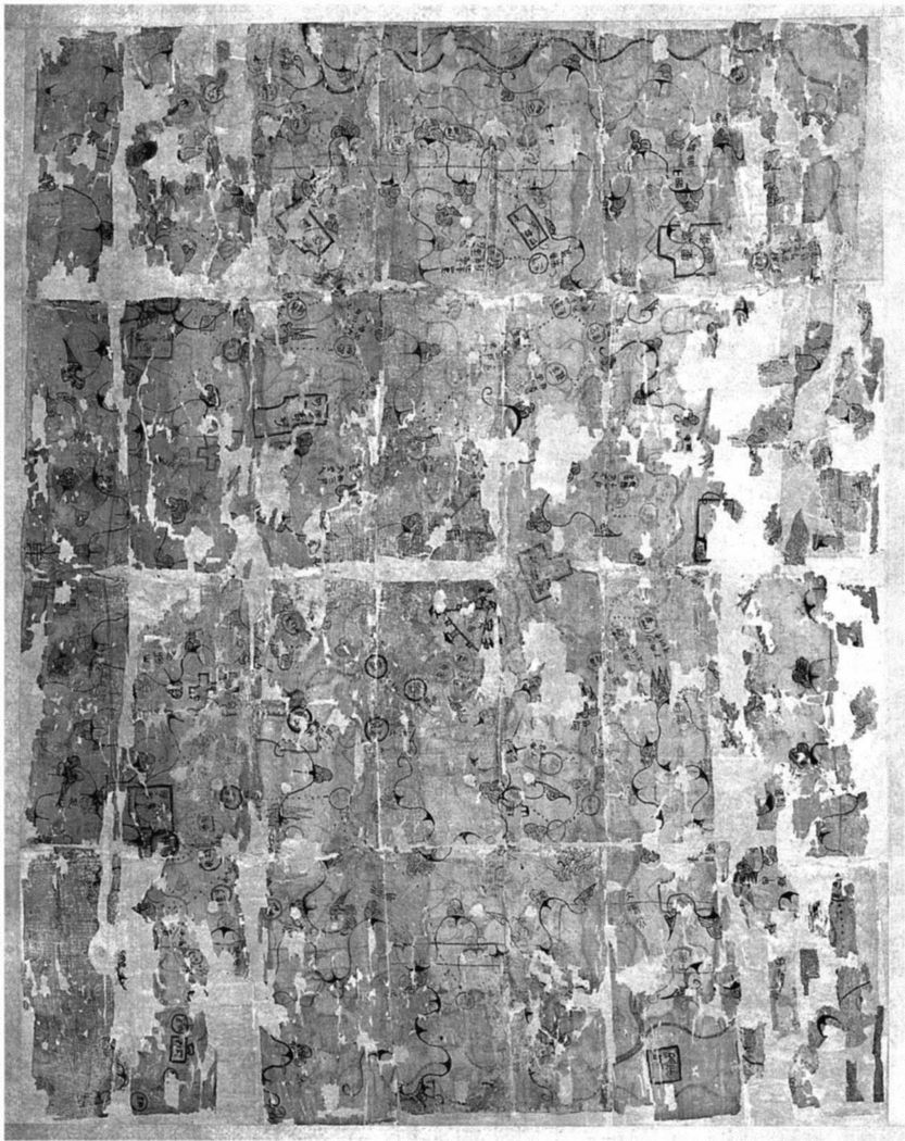
The current study presents a new spatial analysis of the so-called ‘military garrison map’ (Fig. 1) discovered in Tomb Number Three at Mawangdui 馬 王 堆, a small locality near the modern provincial capital Changsha 長 沙 in Hunan 湖 南. Three large pit-style tombs were discovered at this site; among them, Tomb Number One and Tomb Number Three had both remained intact until modern excavation. Material evidence found in situ indicates that the tombs were built in the early period of Western Han 西 漢 (202 BCE - 9 CE).Footnote 3 Further, the wealth of funerary accoutrements reflects the material culture of the provincial nobility of the time. A wooden tablet found in Tomb Number Three records that the crypt was sealed in 168 BCE, thus providing the terminus ante quem for all artifacts contained within.Footnote 4 Among the excavated artifacts in Tomb Number Three are three maps. Scholars generally agree on the categorisation first proposed by the Mawangdui Study GroupFootnote 5 that they are a topographic map, a military garrison map, and a county map.Footnote 6 All three maps are equally important historical artifacts; however, the focus of this study is the interpretation of the military garrison map.
Original military garrison map, excavated from Tomb Number Three at Mawangdui, Changsha, Hunan Province. Polychrome on silk. Image used with permission of the Hunan Provincial Museum.

The primary objectives of the Mawangdui Study Group were to restore and to reconstruct the painted images on silk that had survived in fragments.Footnote 7 Subsequent studies focused on cartographic issues such as mapmaking techniques and accuracy of the depicted landscape.Footnote 8 Prior to the discovery of the Mawangdui maps, Joseph Needham and Wang Ling had identified two traditions in Chinese mapping: the analytical, scientific, or qualitative cartography, and the descriptive, religious, or symbolic cosmography.Footnote 9 Needham and Wang's categorisation was further developed by Mei-Ling Hsu after the discovery of the Mawangdui maps.Footnote 10
In this tradition of scholarship, cartography is viewed as a positivistic science progressing toward greater degrees of accuracy, and maps are interpreted as measurable and delimited entities defined by the western conception of space.Footnote 11 This interpretation, however, has been reexamined by Cordell Yee in a more recent study on the history of Chinese cartography. Yee proposes that the positivist interpretation of cartography has led to “a failure to consider the full range of cartographic functions”; he also questions the traditional view that placed much emphasis on the link between mathematics and cartography.Footnote 12 Positivism creates a theoretical framework in which ideas of modern scientific thought are equated with evolutionary progress; the assumption incorporates modern biases on what constitutes development. Therefore, the use of terms such as “scientific, grid-based, accurate, and measurable” restricts interpretation to a pre-determined set of criteria that incorporates an inherently modern western theoretical perspective. Instead of a positivist approach, Yee suggests that maps should be examined from the perspective of their original purpose and the context in which they are discovered. But how can modern researchers assess the original purpose of an excavated ancient map and its context?
Archaeological theory offers multiple frameworks for the analysis of ancient material cultures. Both cognitive and postprocessual archaeology are concerned with the archaeological “other”, the identification of the agents, or the people, behind the artifacts and archaeological features. The modern researcher's challenge is to reconstruct, understand, and interpret what and how ancient societies and individuals thought.Footnote 13 Maps are rare archaeological finds; in the case of the Mawangdui military garrison map, the discovery was truly exceptional. Some scholars have suggested that maps – as artifacts that have the potential to communicate information of a specific culture through the use of annotations and illustrative symbols – can be said to possess their own language.Footnote 14 Maps can be treated as ethnographic texts and ‘read’ on a number of different levels, from the literal textual annotations, the semiotic interpretation of illustrative symbols, to a larger context in which they were discovered.
An alternate starting point begins with the assumption that maps represent landscapes real or imagined. The explanation of landscape used in this study incorporates Ingold's notion that a landscape is defined by an individual or a culture and that it reflects the “cognitive or symbolic ordering of space”.Footnote 15 The term ‘landscape’ originated from the development of European landscape painting from the fifteenth century through to the nineteenth century. Instrumental in this definition is the role of the viewer or painter in selecting elements of the landscape (real or imagined) for inclusion or exclusion in the painting.Footnote 16 Despite the emerging recognition of landscape as a cultural and social phenomenon, the concept remains unstable and is subject to new interpretations and shifting definitions.Footnote 17 The fallacy of ‘nature’ untouched by ancient or modern man prevails; however, archaeology has demonstrated the pervasive and almost complete impact of man on the environment.Footnote 18
Landscapes are therefore conceptualised images that are “a pictorial way of representing, structuring, or symbolising surroundings”.Footnote 19 Ancient maps were not intended to be accurate according to a set of modern scientific standards. They represent neither a purely scientific and analytic tradition, nor a purely interpretive and artistic tradition. The practice of descriptive mapmaking with its emphasis on generalised pictorial depictions of landscape, accompanied by detailed annotations, has been popular throughout Chinese history. The development of a scientific mapping tradition in China, appears however to be a series of fits and starts rather than a continual progression toward a modern western standard of cartography.
The current study takes a new approach to understand the meanings and values of the military garrison map using spatial analysis tools within a Geographic Information System (GIS). Geographic information systems are interrelated databases actively linking geographically referenced data. GIS enables the comparison of multiple data sets and the ability to create new geographically referenced data.
A GIS-based approach to the Mawangdui garrison map provides an opportunity to explore early Chinese cartography on three levels: as a specific category of material culture within its archaeological context, as a historical document concerning a little known war on the fringes of a new and expansionist empire, and as an ethnographic text and an illustrated narrative depicting a culturally-determined landscape. An attempt to re-create or view a landscape from the perspective of a second century BCE mapmaker presents a two-fold challenge–identifying the biases of the modern researcher, and attempting to view the representative landscape depicted on the map through the eyes of its maker and users.
The underlying methodology of this project, as a GIS analysis, was heterarchical. The data were primarily treated as unranked categories to be compared with one another. They were then manipulated in the GIS to the extent possible with the available resources to see what rankings and groupings would occur. The initial step was to scan the reconstructed maps produced by the Mawangdui Study Group in the late 1970s. As digitised (j.peg) images, the maps lacked a reference to a coordinate system. In order to obtain an approximate orientation for features within the two maps, the maps were first rotated, geo-referenced and warped using the GIS. The Mawangdui Study Group had identified the latitude and longitude of the area depicted in the topographic map; in addition, they also determined that the garrison map is a detailed view of a specific area in the southeastern section of the topographic map. They did not, however, identify the longitude and latitude of the area depicted in the garrison map.Footnote 20
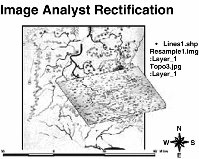
For this reason, our first step was to create a baseline using geo-referencing tools in the GIS. The topographic map was geo-referenced based on the coordinates derived from the initial study of the Mawangdui Study Group and a map of the modern region obtained from the FDMA (Fundamental Digital Map of China).Footnote 21 The FDMA data were supplemented with additional data obtained from the Army Map Service from the National Archives.Footnote 22 A minimum of four common points is required for this type of image-on-image rectification in the GIS. Next, we experimented with geo-referencing the garrison map against the same modern data, but the results were deemed useless, as the image was warped beyond recognition due to significant margins of error. Results of the experiment were expectedFootnote 23 and insignificant to the success of this study, as scientific accuracy of the original maps was not relevant to the primary research question. A more suitable means of geo-referencing the garrison map was to rectify it against the topographic map, based on four common points found on both maps.Footnote 24 The resulting garrison map was reshaped in the rectification process, but not altered to an extent that would prohibit spatial analysis (Fig. 2).Footnote 25
Image-on-image rectification of the garrison map against the topographic map in the GIS, based on four corresponding points.

The two-scaled images were used as a baseline for copying the map data into individual map layers by feature types. The features were divided into classes based on the annotations from the original map, which had been reconstructed and interpreted by the Mawangdui Study Group.Footnote 26 These classes included bodies of water, mountains, roads, military facilities, and cities and villages that can be divided into three categories: those that were obliterated, those that were consolidated, and those that were listed by name only without further annotation. Each feature was digitalised as a separate point, line, or polygon.Footnote 27 In addition, these illustrated features were linked to annotations from the maps in tables, such as population data.Footnote 28
The data resulting from the GIS analysis supplement the historical accounts of a military conflict between the Han and a tributary kingdom, known as the Southern Yue, recorded in Shiji 史 記 (Records of the Grand Historian) and Hanshu 漢 書 (History of the Former Han). Descriptions of the enemy in both Han texts are nearly identical, with one minor difference. In Shiji, the region is consistently referred to as Nanyue 南 越.Footnote 29 In Hanshu, however, two terms were used interchangeably, Nanyue 南 越 and Nanyue 南 粵;Footnote 30 an annotation by Yan Shigu 顔 師 古 (581–645) indicates that Yue 粵 was the antiquated form of Yue 越 and that the two were homophones.Footnote 31 Both sources describe Nanyue to be populated by the Yue people, one of several non-Chinese ethnic groups on the fringes of the early Han empire.
This region, which initially encompassed modern Guangzhou 廣 州 and northern Vietnam, was first conquered by the Qin 秦 in 214 BCE;Footnote 32 the conquered territories were known collectively as the Nanhai 南 海 military commandery and became “an oubliette for China's undesirables” due to its remoteness.Footnote 33 Military officials were sent to colonise the area, but convicts made up the majority of the immigrant population.
Among the colonists was a northerner named Zhao Tuo 趙 佗 from Zhending 真 定 (in modern Hebei 河 北). Zhao first served as a magistrate under Ren Xiao 任 囂, the military commander of Nanhai.Footnote 34 Recognising Zhao's leadership potential, the ailing military commander appointed Zhao as his successor and encouraged him to “take advantage of the disorder in the north and to set up an independent kingdom in the region of Panyu 番 禹 (near modern Guangzhou)”.Footnote 35 During the period of disorder that ensued the demise of Qin, Zhao conquered and annexed the neighbouring areas of Guilin 桂 林 and Xiangjun 象 郡,Footnote 36 subsequently declaring himself the king of Nanyue.Footnote 37 In 196 BCE, the founder of Han, Emperor Gaozu 高 祖 (Liu Bang 劉 邦), enfeoffed Zhao and encouraged him to “unite all the Yue people in peace so that they would not cause any disturbance along the southern frontier adjoining the border of Changsha”.Footnote 38 Changsha was one of ten principalities established by Liu Bang at the onset of his reign, but the only one not governed by a member of the imperial family.Footnote 39 Changsha's rugged terrain and remoteness from the capital are likely reasons for Liu Bang's willingness to entrust the control of the region to an outsider, demonstrating the central government's view of the region as relatively unimportant.
From Zhao Tuo's perspective, Changsha however was the next target in his expansionist strategy. Historical records suggest that Zhao maintained peaceful relations with the Han until 183 BCE. By this time, Liu Bang had been dead for more than a decade, and his widow Empress Dowager Lü 呂 was ruling as regent. Shiji and Hanshu both document that the Empress Dowager issued an edict prohibiting the export of iron products to Nanyue and that her action provoked Zhao to rebel in the spring of 183 BCE.
Reasons for Lü's edict are unclear, but a fragment of a Han law preserved in a commentary by Ying Shao 應 韶 in Hanshu suggests that the edict was part of a general campaign to prevent the proliferation of weapons among potential enemies.
律 , 胡 市 , 吏 民 不 得 持 兵 器 及 鐵 出 關 , 雖 於 京 師 市 買 , 其 法 一 也 °Footnote 40
The law of “Barbarian markets”: Neither officers nor common people are permitted to go out through the pass carrying weapons or iron. Even if they have been purchased in the capital, the law is still the same.Footnote 41
Although the prohibition was not directed toward Nanyue exclusively, Zhao Tuo must have interpreted it as a significant insult, for he responds indignantly:
“高 帝 立 我 , 通 使 物 , 今 高 后 聽 讒 臣 , 別 異 蠻 夷 , 隔 絕 器 物 , 此 必 長 沙 王 計 也 , 欲 倚 中 國 , 擊 滅 南 越 而 并 王 之 , 自 未 功 也 °”Footnote 42
“Emperor Gao established my authority; he sent his envoy to give me the permission to trade. But now Empress Dowager Lü, listening to the advice of slanderous ministers, has alienated me by treating me as a barbarian and prohibited our trade of iron goods; this must be the stratagem of the king of Changsha, who hopes to rely on Han forces to attack and eliminate Nanyue, so that he can annex it, become its king, and consider it his own achievement”.
Justifying his actions as proactive defence, Zhao unleashed a series of attacks on Changsha. It can be surmised that Zhao's invasion of Changsha was a calculated risk based on his observation of Changsha's insignificance in Han geopolitics:
於 是 佗 乃 自 尊 號 為 南 越 武 帝 , 發 兵 功 長 沙 邊 邑 , 敗 數 縣 而 去 焉 ° 高 后 遣 將 軍 隆 慮 侯 覽 往 擊 之 ° 會 暑 濕 , 士 卒 大 疫 , 兵 不 能 踰 嶺 ° 歲 餘 , 高 后 崩 , 即 罷 兵 ° 佗 因 此 以 兵 威 邊 , 財 物 賂 遺 閩 越 西 甌 駱 , 役 屬 焉 ° 東 西 萬 餘 里 , 迺 乘 黃 屋 左 纛 , 稱 制 , 與 中 國 侔 °Footnote 43
Consequently, Zhao Tuo proclaimed himself the Martial Emperor of Nanyue, and unleashed his forces to attack the border towns of Changsha. His forces captured several towns before returning to Nanyue. The Empress Dowager commissioned a general, the Marquis of Longlü, to inspect the situation and launch a forward strike against the king of Nanyue. Longlü's forces encountered heat and humidity, for this reason most of his soldiers fell ill, and could not cross the mountains. A year and some months later, the Empress Dowager passed away, so the Han court withdrew. Tuo then deployed his forces to threaten the borders once more. With money and goods he bribed the peoples of Minyue, Western Ou, and Luo, convincing them to submit to his authority, so that his territory extended more than ten thousand and some li to the east and the west. Then he started parading around in a carriage covered with a yellow canopy and decorated with plumes on the left side. He called his commands “edicts”. He showed that his power rivalled that of the emperor of China.
Zhao's gamble paid off. He expanded his domain by pushing back Han's southwestern border. More importantly from a policy perspective, the success of his “proactive defence” strategy further strengthened his authority over the native population. For the Han, Zhao's encroachment of Changsha forced the central government to re-evaluate the level of threat from the former vassal state, now enemy, in the south.
Historical records indicate that the two sides reached a stalemate after Nanyue's initial forays; following the stalemate, Han Emperor Wen 文 帝 was able to prevent further territorial losses through a series of diplomatic manœuverings, and persuaded the reluctant Nanyue king to resubmit to Han sovereignty.Footnote 44 Zhao never launched another attack on Changsha, but he also never reverted to acting like a vassal. Han spies reported that Zhao continued to behave like an emperor in his domain;Footnote 45 this observation was confirmed by the modern discovery of a set of imperial seals in the tomb of Zhao Tuo's grandson at Xianggang 象 崗.Footnote 46 Nanyue would remain an autonomous kingdom until 108 BCE, when it was attacked unexpectedly by Han Emperor Wu's 武 帝 forces via a navigable route to its capital Panyu.Footnote 47 Consequently, nine new military commanderies were established there and placed under Han's direct control.Footnote 48
The garrison map, when treated as a graphic and numeric picture, yields a wealth of information about this historical conflict. Initially, our analysis focused on the map as an illustrated narrative. We attempted to address the emic perspective by asking which questions were relevant to the mapmaker and users – tactical and administrative relevance of the military hierarchy, the military facilities, and the population data. The first question we thought would be significant was the location of the fighting vis-à-vis the population data.
The process of ranking, re-ranking, and creating different spatial displays with the data revealed that our initial categories and questions were inadequate to describe the information inscribed on the map. The data are intermittent and not readily apparent from the annotations alone. The combination of categories derived from annotations (military commander titles, key location names, consolidated villages and obliterated villages) with a graphical depiction of these features in the GIS, allowed a picture of military planning versus tactical reality to emerge. The GIS analysis clearly shows that the map represents a defensive military posture, a conjecture first posited by the Mawangdui Study Group in the late 1970s, but not proven until now.Footnote 49 In the most basic interpretation of the raw data, the key features – headquarters of the Han forces and their garrisons – are all depicted within a clearly demarcated perimeter in Changsha territory. Our research also indicates that the garrison map must have been made after the two sides had reached a stalemate, therefore establishing the terminus post quem of the map at around 181 BCE. The defensive posture is evidence that the Han was compelled to amplify is fortification in Changsha and to devise a viable defensive plan to anticipate future attacks. This map illustrates the perspective of the military leaders in Changsha at the time: their immediate objective was not to regain the captured facilities and villages, but to prevent further territorial losses. They could not have predicted what the ancient sources tell us, that the two sides would maintain the status quo for some seventy or more years.
Not surprisingly, the results of the GIS analysis based on the annotations alongside villages and military facilities on the map (see Fig. 5) confirm the historical account that the Nanyue forces had captured several towns in their initial forays into Changsha.Footnote 50 In this aspect, the map serves as an illustrated narrative of a historical event. Our analysis also yielded an unexpected finding: a temporal-tactical dimension to the map. We identified three phases representing tactical planning and periods of time: (Phase I) pre-conflict tactical planning, (Phase II) post-conflict tactical impact, and (Phase III) tactical defensive planning for future attacks.
The progression of time in this map is signified by a combination of annotations and illustrative symbols. By viewing the map from the position of their intended users – field-level military officers and their chief commander, presumably also the owner of the tomb in which the map was found – we observe tactical changes that correlate with the progression of time.
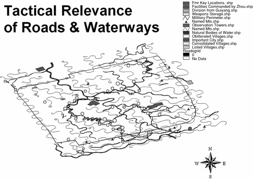
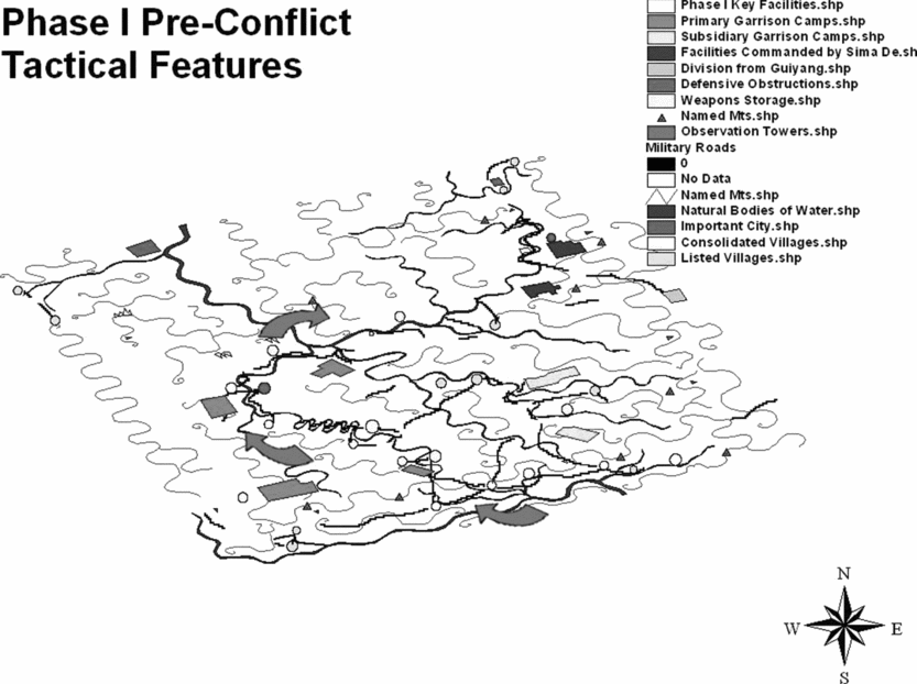
In Phase I, we interpret evidence of pre-conflict tactical planning on the part of the military leaders of Changsha. Data are represented by two categories of map features: former key military and administrative installations,Footnote 51 and relocated and consolidated villages.Footnote 52 When these features are isolated and displayed in the GIS along with other military facilities, rivers, and roads (Fig. 3), a vision of the anticipated route of invasion emerges (Fig. 4). The former administration centre, guguan 故 官 (#53 in the original Mawangdui Study Group's list of map featuresFootnote 53), the former military defence quarter, guhu 故 護 (#54), the former Cheng city, gu Chengcheng 故 乘 城 (#52), and the former Zi village, gu Zili 故 崰 里 (#64), were all probably intact at the time of the pre-conflict tactical planning. The latter three (#54, #52, and #64) protected a major fortified thoroughfare through the mountains on the southern border of the region. This mountain passageway is also the location of the manfeng 滿 封 observation tower (#18).Footnote 54 The consolidated villages are clustered along the thoroughfare that extends to the west and north along the river and over a mountain pass west of the manfeng observation tower. We interpret the consolidation and relocation of these village populations as a pre-conflict tactical strategy, which created a corridor of natural barriers (mountains and bodies of water) and man-made barriers (observation towers, mountain passes, and military facilities) to complement the disposition of the defensive forces. Clearly, the Han strategy was to control the direction of the enemy invasion.
Former key military and administrative installations, and relocated or consolidated villages, shown isolated and displayed in the GIS.

Phase 1: pre-conflict tactical features based on population data of relocated and consolidated villages in the GIS. The arrows indicate the anticipated route of invasion.

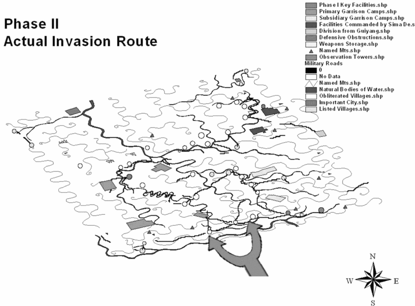
By contrast, in Phase II, we observe the post-conflict results as seen from the perspective of the field commanders (Fig. 5). Despite the tactical planning and the use of barriers designed to direct the enemy invasion along a certain route of roads and mountain passes, separate clusters of obliterated villages depict a two-pronged attack. GIS analysis shows that the original military and administrative facilities were destroyed (including the former Cheng city, the former Zi village, the former military defence quarter in the south, and the former administration centre in the northeast); the analysis further indicates that the actual conflict led to a significant decrease in population. Hsu had calculated that 750 households were affected.Footnote 55 Our analysis concentrates on deriving tactical categories within coding in the GIS, based on households with the annotations of either jin wuren 今 無 人 (presently no one) or bufan 不 反 (did not return). In each instance of village relocation indicated in the annotations, the new location for the village was also listed as ‘depopulated’.Footnote 56 Therefore, the relocation of population did not avert the village's destruction in the actual conflict. We interpret the overall population figures as representative of both Phase II and Phase III, revealing future tactical plans on the part of the Changsha military leadership.
Actual invasion route based on data of former military and administrative installations and obliterated villages. Arrows indicate calculated actual routes of invasion.

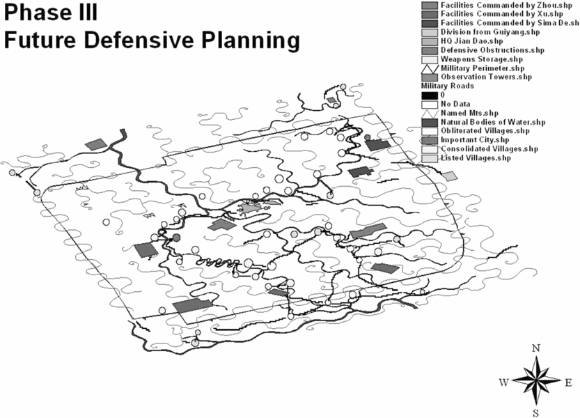
The military perimeter, observation towers, and garrisons are interpreted as the main features of Phase III (Fig. 6). The perimeter connecting the observation towers is drawn to the rear of the ‘former’ military defence quarter, the ‘former’ Cheng city, and the ‘former’ Zi village, which were all obliterated during the conflict. This configuration indicates that some of the observation towers were constructed post-conflict for future defensive purposes. The most important feature in Phase III is the current military headquarters, located in the centre of the perimeter. Our analysis clearly shows that the mapmaker purposefully used the word gu to differentiate the current headquarters from the former military and administrative centres. The new headquarters encompass a fortified gate, men 門, a double-walled protective passageway, fudao 復 道, and an artificial reservoir, bo 波; since the ‘former’ military and administrative headquarters were both destroyed, this key facility must have been a post-conflict construction. Another feature of Phase III is the devastation as represented by the data of obliterated villages. Rather than concentrating around the military garrisons, which the Han had thought to be the target of attack, the devastation follows road and river routes of access to the former administrative quarter in the northeast of the map.
Features representing future defensive plans.

The original map shows most military facilities located inside the perimeter and within close range to the garrisons. The annotations document that there were three field commanders, surnamed X¨, Zhou, and Sima, controlling eight garrisons of primary and subsidiary ranks. An additional garrison, the guiyang jun 桂 陽 軍, is shown outside the perimeter, but its rank in the command structure is not indicated.Footnote 57 Observation towers faced enemy territory and clustered in the south and east, thereby, defining vulnerable zones of the terrain. This evaluation is significant because it addresses an important research question why only the directions of south and west, were inscribed on the original map.
Finally, the population data for obliterated villages were examined. From the perspective of the military commanders responsible for developing a defensive plan, the inclusion of population data was difficult to interpret in context at first. When viewed from the perspective of available troops for conscription, however, the utility of the figures to the field commanders becomes clear. Although the military leaders may have also taken an interest in the human toll of the conflict, our analysis leads to us to conclude that this particular map was not administrative in nature. Instead, it reflects military reality and tactical planning.
The history of Chinese mapmaking encompasses more than a mere progression toward mathematically-oriented cartography. In this analysis of the Mawangdui military garrison map, the authors considered a broader range of cartographic functions, beyond those addressed in earlier scholarship. In particular, the current analysis is an inquiry into the emic perspective by examining this 2,200-year-old map from the viewpoint of the mapmaker and users in the formative era of the Chinese Empire. Through the use of GIS-aided spatial analysis, we discovered an illustrated narrative of a significant historical event. Questions of scientific accuracy or relation to modern geographic reality were found to be irrelevant to this line of inquiry. The nature of the historical narrative formed the cornerstone of our inquiry into the meaning and use of the map in the second century BCE. The authors treated the annotations and illustrative symbols on the map as a language in itself – a series of communications or data to be analysed and compared with one other. From a historical standpoint, the map provided complex details regarding a military conflict and the administrative challenges resulting from the event.
By treating the map's annotations and illustrative symbols as spatially referenced communications, we were given an opportunity to address questions of relevance and function in the second century BCE. This analysis yielded unexpected results that illustrate a temporal-tactical dimension to the map. The temporal nature of the map goes beyond placing the map in a particular time and place to providing information on the events that preceded the map's creation. Our analysis also confirmed previous conjectures that the map represented a defensive rather than offensive military posture.
The garrison map further illustrates the bureaucratic and military challenges that arose as a result of the conflict, ranging from issues of taxation to conscription and public defensive works. An emic approach enables us to interpret the map as an ethnographic text and to read it from the perspective of the ancient mapmaker and users. This attempt, although inherently imperfect, allows us to re-examine our own biases, open new channels of inquiry, and question previous assumptions concerning the ancient military map. If only for a limited time, we can address issues of use and value. What issues were most important to the mapmaker and users? Our analysis does not support a high value or concern for cartographic accuracy in the second century BCE. Rather, the illustrative symbols and annotations tell a different story – one of immediate military and administrative challenges facing an expansionist empire on the fringes of its control.