Introduction
The initial colonisation of Remote Oceania by Lapita groups in the south-western Pacific probably occurred between c. 3250 and 3000 cal BP (Denham et al. Reference Denham, Bronk Ramsey and Specht2012), and is represented by more than 250 sites that span a vast area, including Melanesia, West Polynesia (Samoa and Tonga) and even (although comparatively rare) the southern coast of New Guinea (McNiven et al. Reference McNiven, David, Richards, Aplin, Asmussen, Mialanes, Leavesley, Faulkner and Ulm2011). Contemporaneous or slightly earlier non-Lapita sites have also been found in western Micronesia, with several in Palau possibly dating to as early as c. 3300–2800 cal BP, and seven or eight in the Marianas dating to c. 3500–3200 cal BP (Fitzpatrick Reference Fitzpatrick2003a; Clark Reference Clark2005; Liston Reference Liston2005; Carson & Kurashina Reference Carson and Kurashina2012). It has been argued that the latter sites represent the earliest entry of humans into Remote Oceania at 3500 cal BP (e.g. Carson Reference Carson2008). Recent re-analysis of radiocarbon dates from Anadara antiquata shells at the Bapot-1 site in Saipan, however, indicate that it may instead have occurred centuries later, at around 3200–3080 cal BP (Petchey et al. Reference Petchey, Clark, Winter, O'Day and Litster2017). Thus, the chronological constraint of colonisation dates in these two different areas of Remote Oceania has implications for understanding and modelling the strategies that Pacific Islanders undertook in their dispersal across the world's largest ocean, in what were arguably the most rapid and expansive maritime migratory movements in the ancient world.
Despite the sheer number of archaeological sites with evidence for colonisation and subsequent early phases of Lapita and western Micronesian settlement, very few of these have yielded human remains that can help address important questions regarding the origins and dispersal of Austronesian-speaking groups. Of those sites containing human remains, only Teouma in Vanuatu, Chelechol ra Orrak in Palau and Naton Beach in Guam (Bedford et al. Reference Bedford, Spriggs and Regenvanu2006; Nelson & Fitzpatrick Reference Nelson and Fitzpatrick2006; DeFant Reference DeFant2008) have a large number of in situ interments found in a single location (although the Naton Beach burials represent a population that may be between two and seven centuries removed from initial colonisation).
The Teouma site is well known for having the largest number of individuals (approximately 100 in 68 discrete graves) and the earliest assemblage of Lapita-period human remains in the Pacific (see Bedford et al. Reference Bedford, Spriggs and Regenvanu2006; Buckley et al. Reference Buckley, Tayles, Spriggs and Bedford2008; Valentin et al. Reference Valentin, Bedford, Buckley and Spriggs2010, Reference Valentin, Spriggs, Bedford and Buckley2011; Kinaston et al. Reference Kinaston, Buckley, Valentin, Bedford, Spriggs, Hawkins and Herrscher2014). Mortuary behaviours included cutting holes in volcanic tephra for the deposition of bodies in a variety of ways, such as single and multiple burials, bone removal, post-mortem manipulation of bodies and at least one cremation—all of which took place for a period of approximately 300 years between c. 3000 and 2700 BP (Petchey et al. Reference Petchey, Spriggs, Bedford, Valentin and Buckley2014). The cemetery at Teouma is overlain by around 0.5m of midden that was probably deposited after the cessation of burial activities, with occupation pertaining to the Arapus and Early Erueti phases (c. 2800–2500 BP) (see Kinaston et al. Reference Kinaston, Buckley, Valentin, Bedford, Spriggs, Hawkins and Herrscher2014).
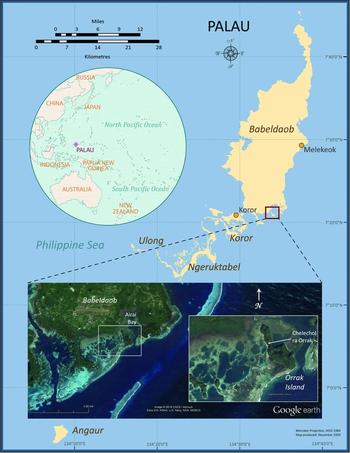
The Chelechol ra Orrak rockshelter (B:IR-1:23) in the Palauan archipelago of western Micronesia (Figure 1) is also a large cemetery, with more than 55 individuals (although some only represented by fragments) thus far recovered from limited excavation at the site. Adults of both sexes are represented, as are juveniles and neonates (Fitzpatrick Reference Fitzpatrick2003a; Nelson & Fitzpatrick Reference Nelson and Fitzpatrick2006). Compared to Teouma, where the vast majority of burials are of adults, the Orrak site has a much broader demographic profile and functioned as a cemetery for a longer period of time (~1000 years). Similar to Teouma, Chelechol ra Orrak is also covered by approximately 0.5m of midden material that contains abundant food remains and artefacts (Fitzpatrick et al. Reference Fitzpatrick, Giovas and Kataoka2011).
Map of Palau, showing the location of Chelechol ra Orrak (drafted by Scott M. Fitzpatrick, courtesy of Google Earth).

Archaeological evidence suggests that Palau was probably colonised by at least 3000 cal BP. The burials at Orrak therefore have great potential for helping to determine the origin(s) of peoples who first settled the western fringes of the north-western tropical Pacific. The site was used extensively in prehistory after burial activity ceased—first as a campsite, and then as a quarry for Yapese islanders to produce their famous stone money (Fitzpatrick Reference Fitzpatrick2003b). These subsequent post-burial activities provide additional and important information on site use over time and how the archaeological record of the most northerly part of the Rock Islands compares to the southern lagoon area (Fitzpatrick Reference Fitzpatrick2003b; Clark Reference Clark2005; Clark et al. Reference Clark, Anderson and Wright2006; Masse et al. Reference Masse, Liston, Carucci and Athens2006).
In an earlier paper, Fitzpatrick (Reference Fitzpatrick2003a) presented a suite of 19 14C dates from the initial 2000 excavation at Chelechol ra Orrak that established the site's first chronological sequence. One of the primary goals was to delineate when burial activities first began and subsequent periods of site use. This was challenging, given the complex stratigraphy and mixing of some skeletal elements through the displacement of earlier interments by repeated burial activities. At this stage, spatial coverage was also limited—only 3m2 had been excavated, and the majority of dates (12 out of 19) previously reported in Fitzpatrick (Reference Fitzpatrick2003a) derived from only a single 1 × 1m unit (TU1/E3S2), with several of the bone dates having large standard errors. Questions remained, however, as to the age of observed but unexcavated burials, when these activities ceased and whether there was an intermittent period of abandonment between the burials and the onset of more domestic activities at the site.
To address these and other issues, excavation continued over four field seasons in 2002, 2007, 2012 and 2015. Thirteen new 14C dates on marine shell and human bone recovered from the site, in conjunction with the previously reported dates from Fitzpatrick (Reference Fitzpatrick2003a), were calibrated with more recent calibration curves, and examined for their validity and integrity using a conservative chronometric hygiene approach (for discussion of various protocols, see Spriggs Reference Spriggs1989; Liston Reference Liston2005; Fitzpatrick Reference Fitzpatrick2006). The dates were then analysed using Bayesian modelling to construct probability ranges for when the site was used. Overall, primarily due to the enhanced spatial and vertical coverage garnered from subsequent excavations, the results provide a more secure range of both mortuary behaviours, which began c. 3000 cal BP, and domestic activities occurring after those.
Environmental and archaeological background
Palau
The main Palauan archipelago comprises hundreds of islands and islets that stretch for approximately 150km in a north-east to south-west configuration, between 7–8° north of the equator in the north-western tropical Pacific. While there is a great deal of geological variation within the Palau group, ranging from the large volcanic island of Babeldaob to atolls such as Kayangel in the north, the greatest number of islands derive from uplifted coral reef systems that are often referred to as the ‘Rock Islands’. These islands are generally less than 100m high, with jagged karst topography, steep ‘V’-shaped valleys, solution fissures, sink holes and an abundance of caves and rockshelters with flowstone formations. Archaeological evidence indicates that many of the Rock Islands were used during the earlier stages of prehistoric occupation for burying the dead, and at least one (Ulong) appears to have been occupied fairly continuously over the last 3000 years (Clark Reference Clark2004, Reference Clark2005; Nelson & Fitzpatrick Reference Nelson and Fitzpatrick2006; Fitzpatrick & Nelson Reference Fitzpatrick and Nelson2008). Between c. 900 and 600 cal BP, stonework villages—which initially began around 900–800 BP on Babeldaob and Koror—appeared on some of the larger Rock Islands in the southern Lagoon (Masse et al. Reference Masse, Liston, Carucci and Athens2006). This period generally coincides with an increased pattern of coastal site occupation across the archipelago. Later (c. 550–400 cal BP), these Rock Island villages seem to wane in use.
Chelechol ra Orrak
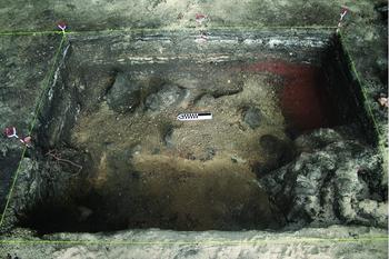
Chelechol ra Orrak is located on the western edge of the small island of Orrak in the northern Rock Islands of Palau (Figure 1). The site consists of a series of small caves and rockshelters that stretch along the coast for approximately 50m. Most of these appear to have been used fairly late in time by the Yapese for stone-money quarrying (Fitzpatrick Reference Fitzpatrick2003b), and briefly by the Japanese during the Second World War. The largest rockshelter, which is the focus of this research, has been excavated in a series of 1 × 1m (n = 14) and 0.5 × 1m (n = 2) units across the central part of the site, covering a total surface area of 15m2 (Giovas et al. Reference Giovas, Fitzpatrick, Kataoka and Clark2016). Site stratigraphy is complex, with burial deposits comprised of loose coral sand generally found between 0.5 and at least 1.1m below the surface (mbs). Deeper deposits begin to turn to a much harder, consolidated calcrete due to repeated tidal action that, depending on daily intensity, can occasionally intrude into the units at depths exceeding 1m. In some areas, larger limestone rocks appear to have been used to cap the coral sand matrix post-burial. The upper 0.5m±0.1m is an undulating series of strata marking temporary occupational episodes with a rich artefact and faunal assemblage. Some parts of the site (e.g. unit E1S4) clearly show numerous sequential deposits indicative of frequent and repeated burning, presumably from fires used for cooking (Figure 2). Various analyses on the skeletal assemblage are still underway, including craniofacial morphometrics, aDNA extraction and both light and heavy stable isotopes. It is clear that Chelechol ra Orrak holds vital clues to the origins of early Micronesians, with great potential to illuminate our understanding of ancient Pacific population dispersals into Remote Oceania.
Eastern profile of two 1 × 1m units E1S4 (left-hand corner) and E1S5 (right-hand corner), demonstrating a clear distinction between the brown/yellowish sand of the burial deposits and the sequential occupational episodes above, which undulate between 0.4 and 0.6/0.7mbs (photograph: Scott M. Fitzpatrick 2007).

Methods
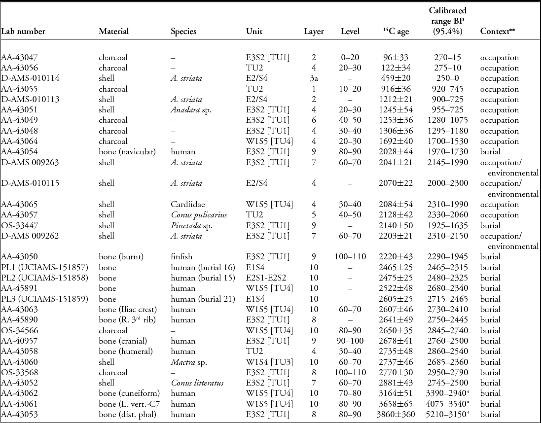
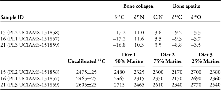
For our analysis, we combined the 19 previously reported 14C dates (Fitzpatrick Reference Fitzpatrick2003a) with 13 new accelerator mass spectrometer (AMS) dates on marine shell and human bone (Table 1). We calibrated 14C dates from human bone fragments using several different mixed marine-terrestrial curves (diet 1: 50:50 per cent; diet 2: 75:25 per cent; and diet 3: 25:75 per cent) to account for diets that contained both food resources. Preliminary isotopic data from 19 samples at Orrak, including burials 15, 16 and 21, for which we have direct AMS dates, show a moderate to high marine dietary signal in both protein bone collagen and total diet bone apatite fraction (Table 2; Krigbaum & Fitzpatrick Reference Krigbaum and Fitzpatrick2009). Further analysis of specific individuals may warrant recalibration with more specific marine-terrestrial ratios. For our analysis, a ratio for diet 1: 50:50 per cent was incorporated for the mixed marine curve.
Radiocarbon dates for Chelechol ra Orrak (B:IR-1:23) in chronological order.

* Removed from the analyses based on outlier analysis and chronometric hygiene.
** Context refers to the Bayesian model classification phase (occupation or burial). Samples that may have been deposited naturally are further identified as environmental.
AA = University of Arizona; OS = Woods Hole Oceanographic Institute; D-AMS = DirectAMS; UCI = University of California, Irvine.
δ 13C, δ15N and carbon:nitrogen ratios for bone collagen, and δ13C and δ18O for bone apatite for three human individuals. Dietary scenarios illustrate a hypothetical increase or decrease in percentages of marine diet showing calibration changes to radiocarbon dates at 95% probabilities using IntCal13 and Marine13 (∆R –55±22).

We used the IntCal13 curve for charcoal and other terrestrial non-human samples; marine shells were calibrated using the Marine13 curve (see Bronk Ramsey Reference Bronk Ramsey2014) and further adjusted using a ΔR of −52±22 (see Petchey & Clark Reference Petchey and Clark2010). It should be noted that there are only two ΔR values for Palau, which are quite disparate: −52±22 14C years for the south-west lagoon, and 75±68 14C years for the open ocean. Given that there are currently no marine reservoir corrections for the northern Rock Islands or eastern coast of Babeldaob, the dates as presented here will need further adjustment based on any new ΔR values for areas closer to Orrak. The oceanographic conditions surrounding Palau are complex, encompassing numerous major currents, eddies, upwelling or downwelling (and seasonal variations of these). It therefore seems probable that ΔR values could differ substantially, depending on location and environmental context (as was noted by Petchey & Clark Reference Petchey and Clark2010), but also by the specific taxa used and the age of the sample.
For Bayesian analysis, we used OxCal v4.3 software (Bronk Ramsey Reference Bronk Ramsey2009a), running two groups as phases (see online supplementary material (OSM) 1–3). Occupation dates included samples that were generally recovered between 0 and 0.6mbs and from strata 1–5, although the complexity and undulating nature of the stratigraphy at the site prevents these from being stringent categories (i.e. occasionally, evidence for burial activity may have been observed above the ~0.6m mark and vice versa). Dated burial samples were comprised of human bone, one finfish and one Pinctada sp. shell, the latter two of which were directly associated with burials. To generate 95 per cent probability ranges (2σ) for the site chronology, we separated the 14C determinations into two discrete series that encompassed occupation and burial phases. For our analysis, we provide the occupation and burial boundaries, including the minimum and maximum posterior probability ranges and agreement indices for overall (Ao), and modelled (Am) for each sequence (see Bronk Ramsey Reference Bronk Ramsey2000, Reference Bronk Ramsey2001, Reference Bronk Ramsey2009a & Reference Bronk Ramseyb, Reference Bronk Ramsey2014).
Thirty-two 14C determinations were used for the Bayesian analysis, which comprised 14 from the upper strata occupation phase, and 18 for the lower burial phase. The occupation phase included 14C samples taken between ~0.7 and 0mbs down to the deepest deposits in layer 7 (TU1/E2S3). For chronometric hygiene, we conducted outlier analysis using Bronk Ramsey's model (Reference Bronk Ramsey2009b) where: Outlier_Model(“SSimple”,N(0,2),“s”) (see Table 1 and the OSM). Two of the 18 14C dates contained agreement indices less than 0.02 and were identified as outliers (AA-43061 and AA-43062) and thus removed from the analysis. A third 14C date (AA-43053) was also rejected because of its high standard error of ±360.
It should be noted that these three 14C dates were from unarticulated or isolated bone fragments included as part of the original study (Fitzpatrick Reference Fitzpatrick2003a) to help determine the age of the cemetery. These dates, as confirmed by the outlier analysis, had either a large standard error (3860±360, AA-43053), or were anomalously old compared to other dates in the same strata/levels (3658±65, AA-43061; 3164±51, AA-43062). When calibrated, these dates are all pre-3000 cal BP (see Table 1) and relatively close in age to the other sequence of dates, which extend back to between c. 2800 and 2700 cal BP. In addition, both tidal influx, which can encroach into the units at around 0.9–1mbs depending on its amplitude, and the calcrete matrix encountered at this depth make excavation difficult and have limited the recovery of human remains. Given these accessibility issues, it is quite possible that burials extend even deeper and that the cemetery's age could reach back earlier than c. 3000 cal BP.
The remaining dates from charcoal, shell and fish bone were deemed acceptable based on a relatively conservative chronometric hygiene protocol. This included samples derived from unidentified charcoal and marine molluscs that were assumed to be cultural in origin based on their association with other cultural materials, or with having been processed or modified (e.g. pearl shell artefacts; see Fitzpatrick & Boyle Reference Fitzpatrick and Boyle2002). Of the eight charcoal dates from Orrak, all were submitted during a time when taxon identification was not widely done. As Petchey et al. (Reference Petchey, Spriggs, Bedford, Valentin and Buckley2014: 227) also note, it is often difficult to identify wood charcoal to a species in the Pacific, particularly with a lack of good reference collections. The 11 marine shell samples were taken primarily from juvenile or short-lived species, and in most cases also fall within the expected age ranges based on other associated dates and/or strata. We acknowledge that the identification of charcoal to taxon and the exploration of possible inter- and intra-shell age variability will be important in developing future chronological models for this and other sites on Palau.
Results
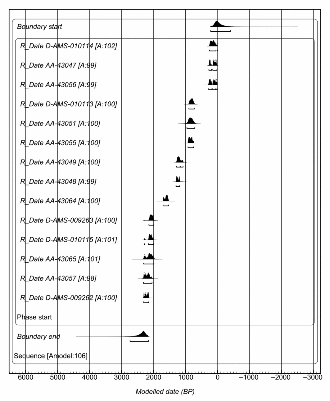
For the 14 radiocarbon dates from the occupation phase, agreement indices are Am = 118 per cent and Ao = 123 per cent, with the modelled 95 per cent probability ranges for the earliest modelled posterior boundary between 2730 and 2160 cal BP. The latest 95 per cent probability modelled boundary range is between 230 and 0 cal BP (Figure 3). The earliest dates for this component are consistently modelled between 2300 and 2000 cal BP (DAMS-009262, AA-43057, DAMS-009262, DAMS-009263 and DAMS-010115). The latest modelled posterior 14C dates with 95 per cent probabilities range between 285 and 0 cal BP (AA-43047, AA-43056 and DAMS-010114).
Modelled 14C within 95% probability ranges for the occupation phase of the upper strata at Chelechol ra Orrak, B:IR-1:23. Model shows radiocarbon laboratory identification and agreement indices.

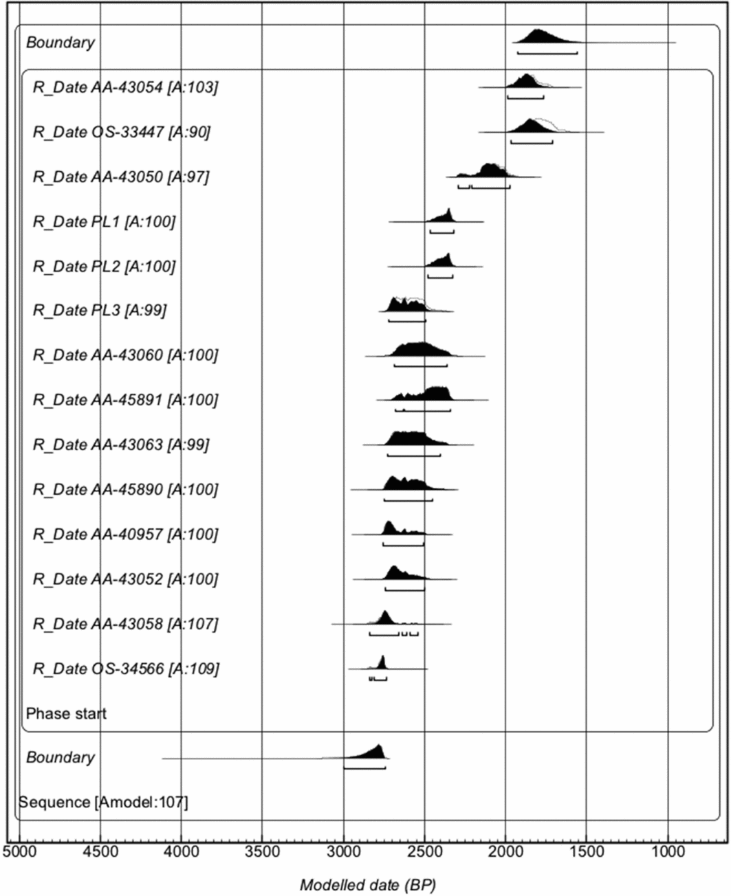
The burial phase produced agreement indices of Am = 102 per cent and Ao = 98 per cent, for a 95 per cent probability of modelled chronology. The earliest posterior 95 per cent probability boundary modelled between 2990 and 2740 cal BP (Figure 4). The latest 95 per cent probability boundary modelled between 1930 and 1580 cal BP. These modelled dates within the burial phase are consistent with those reported earlier by Fitzpatrick (Reference Fitzpatrick2003a), supporting an initial use of the site by as early as c. 3000 cal BP.
Modelled 14C with 95% probability ranges for the burial phase of the lower strata at Chelechol ra Orrak, B:IR-1:23. Model shows radiocarbon laboratory identification and agreement indices.

Discussion and conclusions
Ongoing archaeological research in Palau at a number of sites has provided new insights into when the archipelago was first colonised and subsequent stages of cultural development (Fitzpatrick Reference Fitzpatrick2003a & b; Clark Reference Clark2004, Reference Clark2005; Nelson & Fitzpatrick Reference Nelson and Fitzpatrick2006; Liston Reference Liston2009). Chelechol ra Orrak, however, is the only site in Palau with evidence for early mortuary behaviours that is coupled with later occupational refuse. When combined, these cultural components extend for nearly the entire known cultural sequence (c. 3000 years).
In this analysis, we built on an earlier cultural sequence of the site (Fitzpatrick Reference Fitzpatrick2003a) by expanding the suite of 14C dates to samples from newly excavated units. This broadened the spatial coverage and increased the number of dates from 19 to 32. We then conducted Bayesian analysis to refine when major periods of site use took place (i.e. burial activities vs subsequent occupation). Overall, the results support the use of the Chelechol ra Orrak rockshelter as a cemetery dating back to as early as c. 3000 cal BP, and continuing through to 1580 cal BP. The radiocarbon dates alone suggest that later occupation of the site appears slightly to overlap burial activity, with several dates and the earliest modelled boundary extending back to between c. 2700 and 2100 cal BP.
The modelled 14C chronologies suggest that there was a period of several hundred years in which peoples were both interring the dead and using the site intermittently for subsistence and other domestic activities. It is also worth noting that three of the five ‘occupation’ dates that extend back pre-1900 cal BP are from the small bivalve Atactodea striata, which were directly dated as part of an ongoing palaeoclimatic study (Jew & Fitzpatrick Reference Jew and Fitzpatrick2015). These clams are small, burrowing, short-lived bivalves found in sandy beaches within the intertidal zone, in low- to medium-energy wave washes (Baron & Clavier Reference Baron and Clavier1994). They typically congregate in high population densities, preferring to occupy medium- to coarse-substrate beaches (Baron Reference Baron1992; Baron & Clavier Reference Baron and Clavier1994). As such, they are commonly found in contexts associated with the human remains at Orrak (coralline sand) as probable incidental constituents, and also in occupation layers as a food resource. There is overlap between the end of the occupation and start of the burial phase, which will be addressed in the future once additional dates within this context have been obtained. This will allow for higher resolution modelling and analyses to determine whether there was a hiatus between different episodes of site use.
Two of the A. striata dates (D-AMS 009262 and D-AMS 009263) derive from layer 7 (0.6–0.7m) in unit E3S2, on the boundary between what is recognised stratigraphically as the division between the burials and occupation. These dates could have been included in our analysis as part of the burial phase, if they were interpreted as being non-cultural. Another date (AA-43057) from a marine shell (Conus pulicaris) is also from a deeper occupation layer (layer 5, 0.4–0.5mbs), as is a Cardiidae shell from W1S5 (TU4) in layer 4. This suggests that not all mollusc remains found between 0.4 and 0.7mbs are cultural, given that there was probably some mixing of materials as early Palauans began using the site for subsistence activities, instead of for burying the dead. It is also worth noting that another A. striata sample from layer 3a in E2S4 (D-AMS 010114) dates to the historic or modern period (130–0 cal BP), suggesting that mixing also occurred in the occupational deposits near the surface—perhaps indicative of Yapese quarrying activities for producing stone money (Fitzpatrick Reference Fitzpatrick2003b).
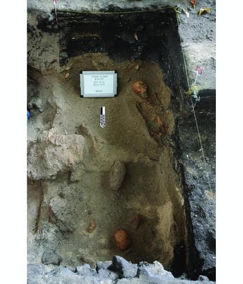
It is clear that certain areas have fairly recognisable and easily defined anthropogenic deposits, while others show rapid, intermittent depositional episodes (e.g. repeated periods of camping and fishing). This is coupled with burial activities in the lower 0.5–0.6m that also became mixed, as some earlier interments were disturbed to make room for later burials. This complex stratigraphy is shown in Figures 2 and 5, where the unevenness of occupational strata is clearly visible in the two major excavation areas, but with much different depositional episodes, despite only being separated by a metre or two. As a result, while the radiocarbon dates appear to show overlapping periods of use (i.e. burials and occupation), this could be the function of the taphonomic and cultural processes described above. The stratigraphic relationships seem to suggest otherwise, with clear distinctions seen between burial and occupational layers, and the former intentionally capped in places by large limestone rocks.
A 2 × 2m section of the northern trench comprised of units E1S2 (top) and E1S1 (bottom), showing an articulated burial (#24) and stratigraphic divisions between the lower cemetery deposits (brown/yellowish coralline sand) and the upper occupational sequence. Note the slight undulation of the upper strata along the southern and western walls compared to the strata illustrated in Figure 2 only 1–2m away from E1S2 and E1S1 (photograph: Scott M. Fitzpatrick 2015).

Overall, our analysis provides a baseline modelled chronology for one of the earliest burial sites in Remote Oceania. Future research at the site will focus on expanding the scope of excavation both horizontally and vertically to help discern the extent of the prehistoric cemetery and the relationship of Orrak to other known Rock Island sites. In the context of more recent dates and re-analysis of the chronology of the Teouma cemetery in Vanuatu (also analysed in a Bayesian framework), initial use of this site for burying the dead dates back to c. 2940–2880 cal BP (and possibly earlier: to c. 2970 cal BP). This is slightly later than what was initially reported (Bedford et al. Reference Bedford, Spriggs and Regenvanu2006) given the incorporation of new dietary offsets used in calibrating the human bone samples, as well as several shell artefact dates directly associated with human remains (Petchey et al. Reference Petchey, Spriggs, Bedford, Valentin and Buckley2014). In addition, the Naton Beach site on Guam contains more than 360 burials, 177 of which date to the Middle Unai Period (c. 3000–2500 cal BP) and has radiocarbon dates on burial-associated shell artefacts that extend from c. 2800–2400 cal BP (DeFant Reference DeFant2008). While they may not necessarily be representative of the earliest colonisation for the Marianas (Petchey et al. Reference Petchey, Clark, Winter, O'Day and Litster2017), they are relatively contemporaneous with Orrak. When compared to the results presented here, the cemetery found at Chelechol ra Orrak in Palau is essentially coeval with Teouma and Naton Beach. Together, these are the three oldest, known cemeteries in the Pacific, with the individuals interred at all of these sites probably representing descendants of the original colonists within a period of 20–30 generations or less after initial settlement.
Acknowledgements
We thank staff from the Palau Bureau of Arts and Culture who have assisted with research on Orrak since the project's inception, as well as students from the University of Oregon and North Carolina State University who have worked on these projects over the course of five field seasons. Greg Nelson and Jessica H. Stone helped to identify human remains selected for dating. We also appreciate the helpful comments from two reviewers who clarified several issues in the paper.
Supplementary material
To view supplementary material for this article, please visit https://doi.org/10.15184/aqy.2017.229