Introduction
The words ‘sky-earth, lake-sea’, a central phrase from the K'iche’ Maya creation story, evoke the importance of climate and water for civilisation in various ways, from air pressure and soils to lake-bed climate proxies and sea level rise. Maya research has maturing climate and water literatures, but major gaps remain in their spatiotemporal trajectories. Nonetheless, these studies represent significant revolutions in Maya archaeology, which are assessed here. Indeed, overcoming these gaps remains among the most compelling challenges in contemporary science and culture.
To understand these aspects of Maya civilisation, we need to understand climate trends, drivers and proxies, hydrography, water management and how Maya scholarship has considered climate and water. The Maya emerged as an agricultural society c. 1000 BC and continue to exist as diverse peoples with many languages. They probably had a practical understanding of how much water they needed for farming, consumption and hygiene, and could discern when changes to water and climate systems became hazardous. Maya archaeology has an important role to play in learning how these considerations link antiquity with modern life.
Environments
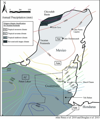
The major Köppen climate types transition north to south across the Maya lowlands from drier to wetter; for example, from steppe-like (BSh) to savanna (AW), to tropical monsoon (Am) and tropical forest (AF) biomes (see Figure 1; García Reference García1981). These climates are derived from proximate weather makers such as surface troughs, cold fronts, tropical waves, stationary fronts, warm fronts, upper level troughs, cold-core lows and mid–upper level lows (Smith & Panton Reference Smith and Panton1986). Longer-term climate change has drivers in sea surface temperature, shifting subtropical high pressure (STHP), the Intertropical Convergence Zone (ITCZ), solar output, aerosols and greenhouse gases, the trade wind belt and ocean-atmospheric-land surface interactions. STHP dominates most often in the dry season, and in the wet season from May to December, the ITCZ shifts northward to the Maya region, bringing greater moisture from atmospheric convergence, surface low pressure, warm sea surfaces and atmospheric instability (Hastenrath Reference Hastenrath1984). The region has high average temperatures, from 26°C in January to 32°C in July, but a wide rainfall range, from <800mm on the rain-shadow of north-western Yucatán to c. 4000mm at orographic sites in the south. This wide range creates large seasonal water deficits and surpluses that require fundamentally different water planning.
Annual precipitation (in mm) of the Maya lowlands.

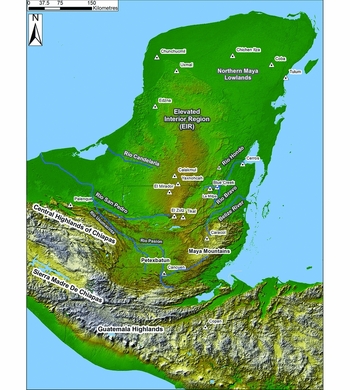
Shallow water tables usually occur at low elevations, such as along the northern Yucatán coast (Figure 2). Here, a lens of fresh water overlies and interfingers with salt water. Salt water ecosystems fringe the coast, pocked with ojos de agua (freshwater springs) that tap the karstic Yucatán aquifer. Inland within the wetland savannas are petenes (islands of tropical forest), around cenotes (sinkholes), intersecting with the water table (Munro-Stasiuk et al. Reference Munro-Stasiuk, Manahan, Stockton and Ardren2014). Some of these appear in north-western Yucatán in a broad ring tracing the Chicxulub meteorite impact crater. The karst depressions here range from thin, linear grikes to sinkholes that run from deep-water cenotes to shallow water dzadz (depressions) and soil filled rejolladas and their larger bajo cousins (Figure 3). These provide moister oases in drier lands (Munro-Stasiuk et al. Reference Munro-Stasiuk, Manahan, Stockton and Ardren2014).
Physiography, hydrology and ancient Maya sites of the Maya lowlands.

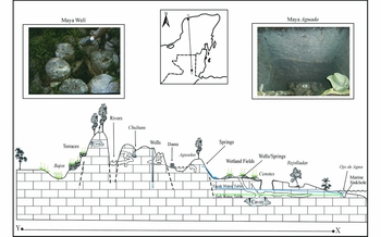
Simplified transect of hydrological settings across Maya lowlands. Left inset: Maya well with stone casing. Right inset: Maya reservoir with plaster and flagstone floor sequence. Photographs by S. Luzzadder-Beach.

The centrality of water
The symbolic and social life of water was just as important to the Maya as their intricate hydraulic engineering. For example, the ancient Maya envisioned water as a living serpent with its own will and agency (Houston Reference Houston, Finamore and Houston2010: 72). Water spawned and supported all manners of enterprise: community organisation, authority, the gods and the earth itself. Water literally surrounded the Maya world and, figuratively, propped up the terrain: the Maya saw their land as a turtle floating on top of the sea (Miller & Taube Reference Miller and Taube1993: 174). They also found water underneath them, pooled in caves and cenotes. Such pools served as portals to the underworld, where various divine beings dwelled and where the Maize God arrived by canoe to renew the world and its harvest. The Maya saw water as life-blood in a very literal sense, equating it with the blood in their veins (Taube Reference Taube, Finamore and Houston2009).
Water anchored settlement patterns as well as socio-political organisation. The Maya did not just settle near springs and cenotes; some organised their supra-household social groups according to who had access to which water sources (Fash & Davis-Salazar Reference Fash, Davis-Salazar, Lucero and Fash2006). They strategically aligned temples and palaces with springs, used them in place names and drew power by linking kings and water (Stuart & Houston Reference Stuart and Houston1994). Scarborough (Reference Scarborough1998) argued that the political goal of royal reservoirs at places such as Tikal was not so much to control people with the threat of withholding water but to make water-based rituals convincing; to show that kings could amass an ecological resource whose vitality everyone understood.
Climate change and proxies
Understanding climate change and human adaptations to it have been two of the greatest challenges in Maya archaeology since the 1990s. Societies accumulate intellectual capital as they better understand and adapt ecosystems over time. Scholars have insight from many sources, including ethnographic studies that show remarkably nuanced environmental knowledge of milpas (rotating small farm plots), fallows and risk-aversive planting strategies (Nigh & Diemont Reference Nigh and Diemont2013).
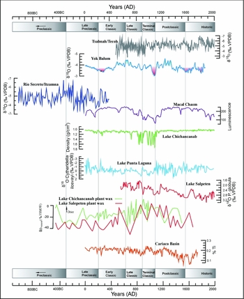
Proxies for understanding long-term climate, including marine and sediment cores, tree rings, speleothems and biogeochemistry of the broader region, are improving (Figures 1 & 4). The marine core from the Cariaco Basin (Haug et al. Reference Haug, Hughen, Sigman, Peterson and Röhl2001, Reference Haug, Gunther, Peterson, Sigman, Hughen and Aeschlimann2003), despite being 2000km south-east of the Maya world, provides a rare, precise, oceanic climate record within the civilisation's timeframe (Haug et al. Reference Haug, Hughen, Sigman, Peterson and Röhl2001, Reference Haug, Gunther, Peterson, Sigman, Hughen and Aeschlimann2003; Ruddiman Reference Ruddiman2013: 64). The Cariaco's proxies include levels of iron and titanium, which, when high, indicate high levels of erosion and rainfall, and possibly human triggers. Between 8000 BC and 3400 BC, rainfall was high but declined until 1500 BC, followed by a period of volatile fluctuation until 400 BC. From c. AD 1–700, rainfall was high and stable, but became low again from AD 700–1000, troughing between AD 1500 and AD 1800. Haug et al. (Reference Haug, Hughen, Sigman, Peterson and Röhl2001) connected the 1500–400 BC instability to increased El Niño Southern Oscillation (ENSO) variability, and the lowest and driest conditions to the Little Ice Age (LIA). The low rainfall from AD 700–1000 was correlated with the Terminal Classic “collapse” (Haug et al. Reference Haug, Gunther, Peterson, Sigman, Hughen and Aeschlimann2003: 1731). The Terminal Classic and LIA droughts also manifested in the tree-ring record of the Montezuma bald cypress (Taxodium mucronatum) from the central Mexican highlands (Stahle et al. Reference Stahle, Diaz, Burnette, Paredes, Heim, Fye, Soto, Therrell, Cleaveland and Stahle2011).
Synthesis of Maya lowlands climate proxy research (after: Hodell et al. Reference Hodell, Brenner and Curtis1995; Haug et al. Reference Haug, Hughen, Sigman, Peterson and Röhl2001; Webster et al. Reference Webster, Brook, Railsback, Cheng, Lawrence, Alexander and Reeder2007; Yaeger & Hodell Reference Yaeger, Hodell, Sandweiss and Quilter2008; Medina-Elizalde et al. Reference Medina-Elizalde, Burns, Lea, Asmerom, von Gunten, Polyak, Vuille and Karmalkar2010, in press; Kennett et al. Reference Kennett, Breitenbach, Aquino, Asmerom, Awe, Baldini, Bartlein, Culleton, Ebert, Jazwa, Macri, Marwan, Polyak, Prufer, Ridley, Sodemann, Winterhalder and Haug2012; Douglas et al. Reference Douglas, Pagani, Canuto, Brenner, Hodell, Eglinton and Curtis2015).

Lake cores provide multiple climate proxies (Douglas et al. Reference Douglas, Pagani, Canuto, Brenner, Hodell, Eglinton and Curtis2015). In the northern Maya lowlands at Laguna Chichancanab, several well-documented studies provided evidence for Terminal Classic drought (Hodell et al. Reference Hodell, Brenner and Curtis1995, Reference Hodell, Brenner, Curtis, Medina-Gonzalez, Rosenmeier, Guilderson, Chan-Can and Albornaz-Pat2005; Escobar et al. Reference Escobar, Curtis, Brenner, Hodell and Holmes2010). Indeed, Hodell et al. (Reference Hodell, Brenner and Curtis1995) set the trend for research into Maya climate archaeology by demonstrating that the Terminal Classic drought, coinciding with widespread population abandonment, was the most severe in seven millennia. The main proxies were increased gypsum (CaSO4 < tex − math/ > ·2H2O) to calcium carbonate (CaCO3) in lake sediments and δ18O in gastropod and ostracod shells to indicate greater evaporation of the lake. With greater evaporation, more gypsum precipitates and more 16O evaporates, leaving shells enriched in 18O (Hodell et al. Reference Hodell, Brenner and Curtis1995). They also provide overlapping historical and δ18O data from three Yucatán lakes for drought in the LIA. Similarly, Petén lakes show greater δ18O and thus evapotranspiration during the Terminal Classic (Yaeger & Hodell Reference Yaeger, Hodell, Sandweiss and Quilter2008: 187–242), but this could also mean reforestation and greater transpiration with Maya abandonment. Based on Lentz et al.’s (Reference Lentz, Magee, Weaver, Jones, Tankersley, Hood, Islebe, Ramos, Dunning, Lentz, Dunning and Scarborough2015) conservative estimate of 30–40 per cent forest survival at Tikal in the Late Classic population peak, watershed reforestation after abandonment would increase transpiration substantially, especially of the lighter 16O-based H2O molecules. In both cases, the greater δ18O and higher evapotranspiration may be explained by reforestation and drier and/or hotter conditions.
Cave speleothem studies have improved the chronological resolution for Maya climate history. The main proxies in caves are again δ18O and δ13C, this time from CaCO3 precipitated on stalagmites, and dated by the uranium/thorium ratio (U/Th). The key studies lie in drier northern Yucatán (Medina-Elizalde et al. Reference Medina-Elizalde, Burns, Lea, Asmerom, von Gunten, Polyak, Vuille and Karmalkar2010, in press) and wetter southern Belize (Kennett et al. Reference Kennett, Breitenbach, Aquino, Asmerom, Awe, Baldini, Bartlein, Culleton, Ebert, Jazwa, Macri, Marwan, Polyak, Prufer, Ridley, Sodemann, Winterhalder and Haug2012), although the plentiful caves of the area have great potential for this proxy's use. All climate proxies reflect their source regions, and speleothems mainly represent small catchments. Hence, a greater distribution and density of studies will provide a better resolution for assessing the complexities of climate change (Figure 4). Two studies from Yucatán at Tsabnah Cave near Mayapan (Figure 4; Medina-Elizalde et al. Reference Medina-Elizalde, Burns, Lea, Asmerom, von Gunten, Polyak, Vuille and Karmalkar2010) and Rio Secreto/Itzamna (Medina-Elizalde et al. in press) near Tulum provide a nearly 3000-year-long record. They indicate a humid period from 400–200 BC, two long droughts near the Terminal Preclassic (c. AD 200) and eight separate droughts from AD 806–935, suggesting an annual rainfall decline of 25–40 per cent and a 30–50 per cent decline for the summer growing and hurricane seasons. Another, less severe, dry period occurred around AD 1600 in the LIA.
Frappier et al. (Reference Frappier, Pyburn, Pinkey-Drobnis, Wang, Corbett and Dahlin2014) used mud deposits in speleothems from another Yucatán cave to record tropical cyclones (palaeotempestology) for the last two millennia. They argue that the Terminal Classic dry period had high tropical cyclone activity, corroborated by Denommee et al. (Reference Denommee, Bentley and Droxler2014) from Belize's Blue Hole, and that tropical storms may have masked drought intensity by flooding caves with anomalously low δ18O. This suggests that overlapping hazards confronted the Maya in the Terminal Classic.
Multiple records with different proxies indicate Late Preclassic drying, wet and stable conditions in the Classic (with some drought in the Early Classic), drought in the Terminal Classic and Early Postclassic and drought again in the LIA (Webster et al. Reference Webster, Brook, Railsback, Cheng, Lawrence, Alexander and Reeder2007; Kennett et al. Reference Kennett, Breitenbach, Aquino, Asmerom, Awe, Baldini, Bartlein, Culleton, Ebert, Jazwa, Macri, Marwan, Polyak, Prufer, Ridley, Sodemann, Winterhalder and Haug2012). The correlation of speleothem dry periods with volcanic activity may suggest a volcanism-aerosol trigger (Ridley et al. Reference Ridley, Asmerom, Baldini, Breitenbach, Aquino, Prufer, Culleton, Polyak, Lechleitner, Kennett, Zhang, Marwan, Macpherson, Baldini, Xiao, Peterkin, Awe and Haug2015).
The ancient Maya may have also changed their climate through land-use changes for agriculture and urbanisation, which could alter aerosol and greenhouse gas cycles, evaporation and transpiration, and albedo and energy balances (Beach et al. Reference Beach, Luzzadder-Beach, Cook, Dunning, Kennett, Krause, Terry, Trein and Valdez2015a). Geoarchaeological imprecision regarding mechanisms for change in land use and climate (Lentz et al. Reference Lentz, Magee, Weaver, Jones, Tankersley, Hood, Islebe, Ramos, Dunning, Lentz, Dunning and Scarborough2015) remains a hindrance, however. Hydrological research suggests deforestation would initially increase runoff, soil moisture and groundwater recharge (Woodward et al. Reference Woodward, Shulmeister, Larsen, Jacobsen and Zawadzki2014), although precipitation would decline over time (Schellekens et al. Reference Schellekens, Scatena, Bruijnzeel and Wickel1999).
Four recent studies have attempted to model drought and ancient Maya impacts on climate. Hunt and Elliot (Reference Hunt and Elliott2005) showed that droughts could occur simply within the range of background variation. Assuming complete deforestation, Oglesby et al. (Reference Oglesby, Sever, Saturno, Erickson, III and Srikishen2010) modelled human-induced drought in the form of increased temperature and decreased rainfall of 15–30 per cent. Cook et al. (Reference Cook, Anchukaitis, Kaplan, Puma, Kelley and Gueyffier2012) simulated a 5–15 per cent precipitation decline, and estimated that deforestation could account for about 60 per cent of the Terminal Classic drying. Finally, Griffin et al.’s (Reference Griffin, Oglesby, Sever, Nair and Iannone2014) study of forest declines showed the effects on local climate, with comparable results found in Brazil (Georgescu et al. Reference Georgescu, Lobell, Field and Mahalov2013).
Greater precision regarding deforestation, reforestation and the time lag of climate in response to changing land use is needed to better model the impact of the ancient Maya on climate. Some studies suggest rapid reforestation, from 80 to 260 years in the Petén, after Maya abandonment (Wahl et al. Reference Wahl, Byrne, Schreiner and Hansen2006; Mueller et al. Reference Mueller, Islebe, Anselmetti, Ariztegui, Brenner, Hodell, Hajdas, Hamann, Haug and Kennett2010), potentially overlapping with the large droughts in the Terminal and Postclassic. Some studies even estimate that reforestation occurred later (Rue et al. Reference Rue, Webster and Traverse2002), post AD 1200, or much later with European conquest (Brenner et al. Reference Brenner, Leyden and Binford1990). This latter reforestation of the Americas may have removed enough atmospheric carbon to play a global role in the LIA (Ruddiman Reference Ruddiman2013).
Climate and culture
Ultimately, archaeology is interested in cultural and historical impacts. Evidence for links between climate and culture include a Mayan hurricane glyph (Dunning & Houston Reference Dunning, Houston, Isendahl and Persson2011) and possible coincidence of demographic and political declines with drought periods in the eighth to tenth centuries AD. During the Late Classic drought periods, deities become conspicuous in iconography of clouds on monuments (Stephen Houston pers. comm.). Some scholars even developed a hypothesis of a Late Classic drought cult and pilgrimage based on changes and growth in cave ritual activity (Moyes et al. Reference Moyes, Awe, Brook and Webster2009), and evidence for increased visits to a series of pools in Belize in the Terminal Classic drought (Lucero & Kinkella Reference Lucero and Kinkella2015).
The most important transformations, so-called ‘collapses’, were drastic population declines in the elevated interior region (EIR) (Figure 2), cessation of support for divine kings and an accompanying priority shift to commerce. Gill (Reference Gill2000) proposed that drought was the primary cause. Others suggest that collapses occurred during the droughts in areas such as the EIR, which lie far above aquifers (Dunning et al. Reference Dunning, Beach and Luzzadder-Beach2012), and later in the northern plains polities such as Chichén Itzá, with easy groundwater access, but neither the archaeological nor the palaeoclimatological data support linear trends (Yaeger & Hodell Reference Yaeger, Hodell, Sandweiss and Quilter2008: 228; Golden & Scherer Reference Golden and Scherer2013). Some of the first areas to collapse were the wetter areas with perennial rivers (Petexbatun and Usumacinta, Figure 2), which implicate declining trade networks as much as drought (Demarest Reference Demarest, Arnauld and Breton2013). Other kingdoms, such as Uxmal, experienced a ‘boom and bust’ within the ninth and tenth centuries AD, when contradictory data suggest no evidence for drought at the nearby X'caamal Reservoir (Hodell et al. Reference Hodell, Brenner, Curtis, Medina-Gonzalez, Rosenmeier, Guilderson, Chan-Can and Albornaz-Pat2005) but substantial evidence near Mayapan (Medina-Elizalde et al. Reference Medina-Elizalde, Burns, Lea, Asmerom, von Gunten, Polyak, Vuille and Karmalkar2010) and Chichancanab (Hodell et al. Reference Hodell, Brenner and Curtis1995). Other polities, such as Chichén Itzá, thrived in dry times while reorienting their economies. For most areas, the resolution is too poor to assess impact, especially an assertion that climatic fluctuations played a primary role in Maya history.
Water management
The ancient Maya managed water for domestic, agricultural, industrial and even security needs (moats). Early commentators noticed Maya hydrological infrastructure such as reservoirs with stone linings (e.g. Stephens Reference Stephens1963 [1843]). A more modern understanding of ancient Maya water-management system complexity developed from the 1970s onward (Matheny Reference Matheny1971; Siemens & Puleston Reference Siemens and Puleston1972; Turner Reference Turner, Turner, II and Harrison1983). These studies laid the foundation for a subsequent profusion of Maya water studies (see online supplementary material for further reading).
Typically, water management is studied through structures including dams, canals, terraces, wells and aguadas (or reservoirs), rather than water itself. To study this requires a uniformitarian assumption of similarity between present-day water chemistry and that of the past due to consistency in the geological determinants of water quality (Luzzadder-Beach & Beach Reference Luzzadder-Beach and Beach2008). This contrast underscores the two main challenges of Maya water resource management: severe seasonal limitations and regional variations in water quality (Luzzadder-Beach & Beach Reference Luzzadder-Beach and Beach2009). Another regional aspect of water quality is the karstic (limestone) geology that can allow water and its pollutants to travel quickly and far (Luzzadder-Beach Reference Luzzadder-Beach2000). Water generally varies from soft (low ionic concentrations) in the uplands, to hard (high ionic concentrations) in the lowlands. In several areas, waters rich in sulphate and calcium merge, creating regional and seasonal variation in quality, a process that probably extended back through antiquity (Luzzadder-Beach & Beach Reference Luzzadder-Beach and Beach2009).
Water management strategies
The ancient Maya developed water management strategies for each region (Figure 3). Groundwater accessibility via natural cenotes and hand-dug wells varies across the Maya lowlands, and can be especially deep and challenging to access in the EIR (Figure 2). The ancient Maya depended on cenotes and rejolladas, or dry sinkholes (Munro-Stasiuk et al. Reference Munro-Stasiuk, Manahan, Stockton and Ardren2014: 156), and chultuns (hand-dug storage tanks) (Matheny Reference Matheny1971) in the north; chultuns, reservoirs and terraces in the EIR; and weirs, diversions, wetland fields, canals and dams along river valleys such as the Rio Hondo, Usumacinta, Candelaria and Rio Copán. In many areas, aguadas and wells collected and stored water, from Quirigua, El Zotz and Tikal in Guatemala (Scarborough et al. Reference Scarborough, Dunning, Tankersley, Carr, Weaver, Grazioso, Lane, Jones, Buttles, Valdez and Lentz2012; Beach et al. Reference Beach, Luzzadder-Beach, Flood, Houston, Garrison, Roman, Bozarth, Doyle, Lentz, Dunning and Scarborough2015b) to La Milpa in Belize (Luzzadder-Beach & Beach Reference Luzzadder-Beach and Beach2009) and Chunchucmil (Luzzadder-Beach Reference Luzzadder-Beach2000) in north-western Yucatán, Mexico.
The Maya capitalised on cenotes and rejolladas for passively collecting and storing water, and managing soil moisture for agriculture in semi-arid north-western Yucatán. Cenotes are often found near ancient sites such as Chichén Itzá, Chunchucmil and Dzibalchaltun. Munro-Stasiuk et al. (Reference Munro-Stasiuk, Manahan, Stockton and Ardren2014: 156) found that settlement and residential groups concentrated in areas with a higher density of these features. They also relied on the more favourable microclimates of rejolladas for intensive agriculture.
Wells are widespread and commonly have stone casings and collars (Figure 3: left inset) to maintain sanitation. Hand-dug wells for accessing groundwater were particularly crucial in the driest areas at places like Chunchucmil (Luzzadder-Beach Reference Luzzadder-Beach2000) and at Uci-Cansahcab in western and northern Yucatán respectively (Luzzadder-Beach & Beach in press). Farther south in the EIR, at sites including La Milpa in north-western Belize, stone-lined wells tap into perennially perched water tables of good quality. Seasonal rainfall seeps through the faulted limestone to recharge the aquifer (Luzzadder-Beach & Beach Reference Luzzadder-Beach and Beach2009) and provide base flow for springs and local rivers (Luzzadder-Beach et al. Reference Luzzadder-Beach, Beach and Dunning2012).
Agricultural terraces serve equally as water- and soil-management features because they provide greater soil depth (and thus water storage capacity) and capture runoff. They may also channel, divert and detain water flow. Some terraces spread across alluvial fans and footslopes to harvest concentrated water flows and some have rock mulches to maintain soil moisture (Beach et al. Reference Beach, Luzzadder-Beach, Hageman and Lohse2002, Reference Beach, Luzzadder-Beach, Cook, Dunning, Kennett, Krause, Terry, Trein and Valdez2015a). The many terraces and the density of five reservoirs per square kilometre of areas such as Caracol demonstrate the region's abundant water landesque capital (Chase et al. Reference Chase, Chase, Weishampel, Drake, Shrestha, Clint Slatton, Awe and Carter2011).
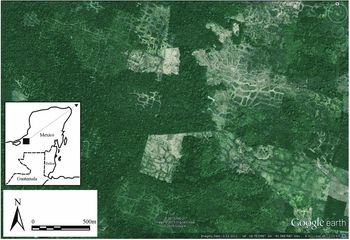
Bajos (large karst depressions) and chinampas (wetland agricultural fields) present two contrasting examples of Maya water management. Ancient Maya ruins sprawl around the edges of bajos but are rarer around perennial wetland field complexes. This is paradoxical because the bajos are too dry and challenging today, while the perennial wetlands hold intensive farming systems. One explanation may be that water management and climate change altered their usefulness, drying the bajos during the Preclassic aridity and creating the wetlands from Holocene sea-level-induced water table rise (Beach et al. Reference Beach, Luzzadder-Beach, Flood, Houston, Garrison, Roman, Bozarth, Doyle, Lentz, Dunning and Scarborough2015b). Indeed, wetland fields and canals were probably the largest ancient Maya water enterprises (Figure 5). They have iconic Mesoamerican progeny in the modern Basin of Mexico at Xochimilco (Morehart & Frederick Reference Morehart and Frederick2014). The main areas of Maya study have been in the perennial wet lowlands along such rivers as the Rio Hondo on the coastal plain of northern Belize (Siemens & Puleston Reference Siemens and Puleston1972; Turner Reference Turner, Turner, II and Harrison1983; Pohl et al. Reference Pohl, Pope, Jones, Jacob, Piperno, deFrance, Lentz, Gifford, Danforth and Josserand1996; Pope et al. Reference Pope, Pohl, Jacob and Fedick1996; Beach et al. Reference Beach, Luzzadder-Beach, Dunning, Jones, Lohse, Guderjan, Bozarth, Millspaugh and Bhattacharya2009, Reference Beach, Luzzadder-Beach, Guderjan and Krause2015c; Luzzadder-Beach & Beach Reference Luzzadder-Beach and Beach2009; Luzzadder-Beach et al. Reference Luzzadder-Beach, Beach and Dunning2012). These field systems include growing platforms with surrounding canals or ditches. The platforms were raised by dredging and depositing sediment, or draining by ditches. Related water-management decisions involved delaying, expediting and diverting flows for quality and quantity according to season and crop (Luzzadder-Beach & Beach Reference Luzzadder-Beach and Beach2008). New satellite imagery showing the size and intensity of wetland farming is growing (Guderjan et al. in press; Figure 5), but these features are a complicated amalgam of natural and anthropogenic interactions. Palaeoecological and geoarchaeological evidence indicates the development of these systems is a late occurrence in the Classic period for wetland systems near Blue Creek, Belize. They may have been a final attempt to adapt to Terminal Classic drying (Luzzadder-Beach et al. Reference Luzzadder-Beach, Beach and Dunning2012). Farther north in Belize, wetland systems extend as far back in history as the Archaic period, with evidence of adaptations to sea-level-induced water table rise and the domestication of farming systems around wetlands and levees (Pohl et al. Reference Pohl, Pope, Jones, Jacob, Piperno, deFrance, Lentz, Gifford, Danforth and Josserand1996).
Satellite image of wetland fields in Campeche, Mexico (source: Google Earth ©2015).

Few rivers exist in the mostly karstic northern Maya lowlands (Figure 2). With few exceptions (Siemens et al. Reference Siemens, Graham, Hebda and Heimo2002), there has been little research on Maya river management (Beach et al. Reference Beach, Luzzadder-Beach, Krause, Walling, Dunning, Flood, Guderjan and Valdez2015d). Siemens et al. (Reference Siemens, Graham, Hebda and Heimo2002) studied ancient dams on the Usumacinta River, but we still know little else about this largest river in Mexico. The Maya diverted the Copán River after AD 700 following more than a millennium of flooding and sedimentation (Turner et al. Reference Turner, Johnson, Mahood, Wiseman, Poole and Baudez1983). As with wetland fields, the Maya Terminal Classic abandonment meant the collapse of their engineering system, and river incision in the Copán valley.
Aguadas have a long history from the Preclassic to the Postclassic (Beach et al. Reference Beach, Luzzadder-Beach, Guderjan and Krause2015c). Scarborough et al. (Reference Scarborough, Dunning, Tankersley, Carr, Weaver, Grazioso, Lane, Jones, Buttles, Valdez and Lentz2012) suggested that Maya sites transitioned reflexively from concave areas near water bodies in the Preclassic to developments around upland reservoirs in the Classic period. This explanation fits some places like El Palmar (Beach et al. Reference Beach, Luzzadder-Beach, Flood, Houston, Garrison, Roman, Bozarth, Doyle, Lentz, Dunning and Scarborough2015b) and El Mirador in Guatemala, but more reservoirs are being discovered from the Preclassic at Xcoch in the Yucatán to San Bartolo in the Petén (Dunning et al. Reference Dunning, Weaver, Smyth, Ortegón and Stanton2014). Some have viewed Classic Maya cities as “water mountains” (Dunning et al. Reference Dunning, Scarborough, Valdez, Luzzadder-Beach, Beach and Jones1999: 657) because of their function to shed water from plaster and stone surfaces to holding basins. These systems require protection from erosion by diverting water in channels from crops or by slowing it with check dams (Beach et al. Reference Beach, Luzzadder-Beach, Hageman and Lohse2002). In contrast, the main goal of hydro-engineering at Palenque in wetter Chiapas was to divert runoff away from architecture (French et al. Reference French, Duffy and Bhatt2012).
At many sites such as Tikal and El Zotz, aguadas had sophisticated engineering, including berms, dams and sealed plaster or stone floors to protect water quality (Figure 3: right inset), as well as holding ponds and possibly sand filters (Scarborough et al. Reference Scarborough, Dunning, Tankersley, Carr, Weaver, Grazioso, Lane, Jones, Buttles, Valdez and Lentz2012). Aguadas were used for managing water quantity and quality and in other capacities such as rituals (Beach et al. Reference Beach, Luzzadder-Beach, Flood, Houston, Garrison, Roman, Bozarth, Doyle, Lentz, Dunning and Scarborough2015b: 278). They required active management to preserve their water storage capacity. For example, the aguada at El Zotz had filled with 1.3m of sediment above its Early Classic flagstone floor by the Late Classic. The community built a new plaster floor over the accumulated sediments, which would have required far less labour than dredging (Figure 3: right inset). The final 1m above this plaster floor has infilled since the Late Classic (Beach et al. Reference Beach, Luzzadder-Beach, Flood, Houston, Garrison, Roman, Bozarth, Doyle, Lentz, Dunning and Scarborough2015b). The implications of this for water quality at the El Zotz aguada highlight the challenges of ancient, and modern, sanitation. The infill of this and other reservoirs with eroded clay sediments would have carried biological and nutrient pollutants.
Conclusions
Climate and water studies are growing but still nascent in Maya archaeology. Records suggest unstable climate fluctuation in the Preclassic, droughts in the Late Preclassic, stability in the Classic period, and droughts in the Terminal Classic, the Early Postclassic and again in the LIA. Speleothem and ocean-core data help to refine drought chronologies and geographies. In order to compare these with archaeological data and relate regional histories to climate records, we must aspire to develop tighter chronologies for Maya sites and proxy records from more areas.
Maya scholarship has excelled at discovering water features and envisioning holistic landscapes of ancient water management, including control over excess water, storage facilities, conservation strategies, defensive mechanisms (moats) and maintaining or improving water quality. These demonstrate Maya ingenuity for resource management in this region's often dilatory dry season. By considering climate change and water management together, we need to understand how or if water management responded to climatic changes beyond general associations. At this point, we can say that wetland field construction was indeed an adaptation to sea level rise because such works could only be built when natural wetlands expanded into formerly dry land in the Archaic to Classic periods. Many wetland fields existed from the Late to Terminal Classic in environments that remained wet throughout these drought periods. They also coincide broadly with the rich water landesque capital of the Maya Classic. It is not currently clear whether water structures correlate with Late Preclassic or Terminal Classic droughts, whether areas nearer groundwater persisted longer, or how successful the Maya were in adapting to hazards. With tighter date ranges and more detailed climatic data records, these connections may soon be explored more successfully.
Acknowledgements
The authors thank the National Science Foundation; the National Geographic Society; the University of Texas, Austin C.B. Smith Sr Centennial Chair; the Georgetown University Cinco Hermanos Chair; N. Dunning; F. Valdez, Jr; T. Guderjan; S. Houston; T. Garrison; J. Doyle; B. Dahlin; H. López Rosas; our research host countries of Guatemala, Belize and Mexico; our students; and the anonymous reviewers. Errors or omissions are the authors’ responsibility.
Supplementary material
To view supplementary material for this article, please visit http://dx.doi.org/10.15184/aqy.2016.38