Extensive geophysical surveys at Gatcombe in 2009 and 2010 revealed a larger Roman settlement than had been suspected when excavations were undertaken at the site in the 1960s and 1970s. This recent fieldwork suggests a settlement of 14.5 ha, enclosed by 5 m thick walls, with dense occupation and significant extramural buildings. The project commenced as part of post-graduate research looking at evidence for post-Roman occupation at Gatcombe, North Somerset (ST 524 698; fig. 7). This note describes the findings from the programme of geophysical surveys initiated to investigate the extent of the settlement.Footnote 108
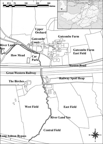
Gatcombe, showing locations referred to in the text. Inset shows site location. (Image source: Wikimedia Commons Author: Nilfanion, used under Creative Commons Attribution Share-Alike Unported 3.0 License)

Gatcombe Roman settlement is situated at the only dry crossing point between Broadfield Down to the south and the Tickenham Ridge to the north, and the lowest part of the site is at an elevation of 40 m above OD. Ashton Brook flows eastwards towards Bristol and the River Avon, while to the west the River Kenn flows past Nailsea to the Bristol Channel. The lowlands to the east and west of the site between the higher regions would have been marshy and difficult to cross before extensive Roman and medieval land drainage works. The site rests on a formation of interbedded limestone and mudstone including the Westbury Formation and Cotham Member. A small brook, the Land Yeo, flows through the site, entering from the south before bending at a right angle to the west. This watercourse seems to have been engineered for much of its course and is, in parts, a banked artificial waterway. Prior to being diverted to the current channel, the brook would have been a source of the River Kenn.Footnote 109 There are several mills along its course, both up- and down-stream from Gatcombe, that are recorded in Domesday. The current course of the Land Yeo now crosses the railway on an aqueduct and no longer follows the route shown on maps of the area drawn up prior to the excavation of the cutting in 1838. The lower part of Roman Gatcombe is probably sealed by a deposit of alluvial silt. This is consistent with Keith Branigan's observations during a watching-brief on a sewer installation crossing the site in 1974, which revealed the Roman and later deposits being sealed by alluvium.Footnote 110
ARCHAEOLOGICAL BACKGROUND
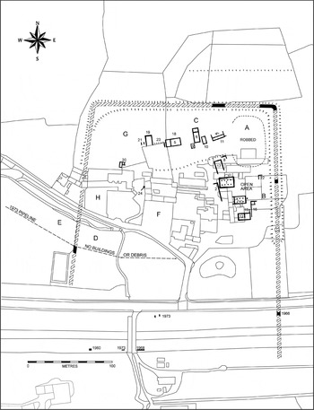
The Roman site was rediscovered during the digging of a deep cutting for the Bristol and Exeter Railway in the late 1830s ( fig. 7).Footnote 111 The full potential of the Roman settlement north of the railway was recognised in the mid-twentieth century by the landowner and confirmed by trial excavations carried out by the Clevedon and District Archaeological Society in 1954.Footnote 112 Several buildings were exposed, as well as sections of the enclosing wall. E.K. Tratman recorded site and surface features,Footnote 113 and in 1965 the University of Bristol commenced a detailed examination of the site, initially by Barry Cunliffe (1965–66),Footnote 114 before Branigan led further excavations from 1967 to 1976 ( fig. 8).Footnote 115 Since that time, little investigative work has been carried out, with the exception of a one-day geophysical survey under the direction of Keith Gardner in 2006.Footnote 116
Plan of the Roman settlement, showing excavated buildings and areas (denoted by letters A to H) as known in 1976. (After Branigan 1976, 8; used with the permission of Keith Branigan)

In his excavation report Branigan postulated that the site was a fourth-century palatial villa, now destroyed by the railway, and that the areas excavated to the north comprised an industrial site separated by gardens along the brook. It was suggested that the heavily defended site was the centre of a great estate under the control of the local procurator and involved in the taxation system.Footnote 117 More controversially Branigan and Fowler noted in 1976 that: ‘The massive late-Roman walls of this settlement are alone sufficient to mark it as an oddity (being nearly 5 m in thickness) but still more anomalous is its situation. Unlike the great majority of walled settlements, it does not lie on or near a major route, or any other known Roman route. The setting of Gatcombe is not appropriate, then, to a small town as that term is commonly understood.’Footnote 118 They also noted that the extent of the settlement could not be established until the south side had been more certainly located.
Notably the earlier excavations included evidence of Iron Age occupation under redeveloped buildings of the fourth century; a sequence of coin finds suggesting continuous occupation of the site through the Roman period; as well as evidence for continued occupation into the fifth century. This late phase of occupation was encountered during the re-excavation of a building first dug in 1954, when it was noted that ‘amongst other things … the latest coins, of Theodosius and Arcadius, were all much worn, suggesting that occupation continued into the fifth century’.Footnote 119 Other indicators include the discovery of burials inside the defences within the area of Gatcombe Court's Upper Orchard. These burials were sealed by the tumble of the defences and Branigan noted that the manner of burial could be paralleled in the post-Roman cemetery at Poundbury. He also noted the discovery of a ‘Chi-Rho’ graffiti found in the ruins of a building, which may provide a Christian context for this late phase.Footnote 120 All the excavation reports note that considerable areas of the site were buried under ‘dark earth’, which ‘had to be removed to find the archaeology’.Footnote 121
ROADS
Some insight into the road system has been revealed through map regression. Two plans of the Long Ashton area from the early nineteenth century depict the field-systems before the railway cutting was excavated in 1838. Details on both plans correspond, with few exceptions, and help to corroborate evidence drawn from excavation and geophysical survey. A pathway is shown that runs from the Gatcombe estate to the north,Footnote 122 which aligns with the hollow way that runs north from the north-west corner of the walled enclosure and seems to be consistent with the Roman road proposed by the Clevedon and District Archaeology Society in 1957Footnote 123 and recorded by Margary.Footnote 124 A hollow way and footpath to the south suggest the possibility of a road connecting with Margary's road 546 to Chew Magna.Footnote 125 The old route of the current Weston Road — as it existed before its diversion to run parallel with the railway cutting — is also shown, with the Land Yeo and its unnamed tributaries running beside the road as they did before they were diverted over the railway cut via a bridged aqueduct. Other than that diversion, the course of the waterway seems to have changed little since the time these plans were drawn up. The east–west road has not, to date, been established as having a Roman association, but its route is suggestive of an early origin, possibly even before the late pre-Roman Iron Age.Footnote 126 The route it follows would have kept it above the marshes and its alignment and position in relation to the Gatcombe enclosure is suggestive of a Roman period of use, which would locate the settlement on a road junction.
GEOPHYSICAL SURVEY: INVESTIGATION AND RESULTS
The aims of the project were to investigate systematically the size of the settlement and to identify locations for further investigation. In particular, it sought to determine whether the settlement extended south of the railway; the extent of the walls and the location of gates and roads through the settlement; and to look for evidence of buildings inside and outside the walls.Footnote 127 Spatial surveys were carried out using the University of Bristol's GPS total station or tape and offset methods. Geophysical surveys were performed using a variety of techniques. Resistivity plan-area surveys were carried out using a TR/CIA Resistance Meter developed for the Council for Independent Archaeology and processed using ‘Snuffler’. The effective depth of penetration for the TR/CIA meter is approximately 0.75 m, although the nature of the overburden and underlying geology can cause variations to this generality. It became clear that in some areas soil creep and flood sediments had deposited depths of overburden over this limit, so other geophysical survey techniques were used. Pseudo-section surveys were carried out using electrical imaging processes and the TR/CIA Resistance Meter, linear data being processed using Res2Dinv. This process uses iterative finite element analysis to reveal the resistivity of buried features along the surveyed section to a depth of over 3 m. Magnetometer plan surveys were carried out by Yatton, Congresbury, Claverham and Cleeve Community Archaeology Research Team (YCCCART) using a Bartington Grad601 Single Axis Gradiometer, a vertical component fluxgate gradiometer. The depth of survey is typically 2 m with a surface spatial resolution down to 0.25 m. The data obtained were processed using ArcheoSurveyor. Caesium Gradiometry Surveys were carried out using Bristol University's G-858 MagMapper gradiometer and analysed with MagMap, supplied as an integral part of the G-858 system. The equipment claims the capability to detect magnetic anomalies to a depth of 6 m.
The investigations at Gatcombe illustrate the value of geophysical survey across a large site where intrusive methods are necessarily limited. In addition the opportunity to survey previously excavated areas provided a valuable aid to the interpretation of site-wide geophysical survey data.
TRACING THE WEST AND SOUTH WALLS
The Roman west and north walls appear in Gatcombe Court's Upper Orchard as earthworks, verified by excavation. A section of the north wall was surveyed by Tim Wilkinson of the University of Bristol as part of an MA in Landscape Archaeology project in 2009.Footnote 128 A resistivity survey of the Upper Orchard illustrates the density of occupation within the walls of the Roman settlement. Branigan excavated the eastern parts of this orchard (area G), but did not explore the western area.Footnote 129 Surface earthworks in the unexplored western area include a hollow way leading from the north-west corner of the walled settlement, the walls, and a number of building platforms. An electric pseudo-section (No. 01) crossing the hollow way showed it to be bounded by walls still about 1 m in height, with building foundations facing the road on both sides. The section shows that much of the stonework lies over 1 m below ground level, which explains why these features do not show up clearly on the resistivity survey (online fig. 1).
Using these techniques the west wall was traced through Gatcombe Court's garden to a location where the garden wall diverges towards the west. The surface of the garden at this location is over 2 m above the lane, with dense resistivity consistent with masonry which suggests the wall survives in the garden. The survey also suggests that the west gate was on the route of the present road.Footnote 130 The enclosure wall could be traced through Gatcombe Court's car park, where a section of it had been exposed during previous excavations, confirming a change in direction at the west gate, on an alignment when extrapolated that would pass under the Birches farmhouse south of the railway. The Birches farm and farmhouse sit on an elevated mound contiguous with and extending south from the spoil heaps of the railway cutting. A resistivity pseudo-section recorded 9 m south of the farmhouse indicates that the modern bungalow straddles the west wall of the settlement. This demonstrates that the west wall extends into the fields south of the railway beyond the accompanying spoil heaps that now host a copse of trees. A series of electric pseudo-sections showed this feature extending into the field to the south.
To determine how far south the settlement extends, YCCCART was invited to carry out a magnetometry survey of the western of three fields south of the railway (online fig. 2). The result, although complicated by interference from power lines crossing the area, shows intense magnetic response activity in the field, bounded to the west and south by the probable alignment of the west and south walls.Footnote 131 A resistivity survey performed at the location seemingly of the south-west corner of the enclosure, as indicated by magnetometry, suggests that the west wall extends south of the power lines, and turns with a rounded corner towards the east. To trace the south wall further, a caesium gradiometer was used in the central field south of the railway. The results of two surveys suggest the wall continues across this area to the east, with the south gate possibly being the high response feature on the line of the modern public footpath (online fig. 3).Footnote 132
WATER SUPPLY
It seems likely that the Romans diverted the stream — the Land Yeo — from its original course in order to bring water into the Roman settlement from the south. Practically this would have been quite a simple operation, since the ground levels mean that very little channelling work would have been necessary. Geophysics performed in the car park suggests the Land Yeo is in a stone channel running beyond the car park and through the west wall.Footnote 133
EXTRAMURAL ACTIVITY
A resistivity survey of the field to the east of the settlement revealed the east wall on an alignment previously established by excavation, together with the route of the road leaving the settlement to the east (online fig. 4). This follows a slight, yet visible, hollow way across the field; this road stayed in use until its realignment in the nineteenth century to follow its present route on the fill from the railway cutting. A previously unknown building was located to the east of the settlement, together with evidence for a relict field-system. A pond adjacent to this building survived to be recorded on the 1841 Cruse and Fox plan.Footnote 134
To the west of the settlement, the area south of Gatcombe Court's garden was surveyed using resistivity, gradiometry and magnetometry. The results suggest not only that there had been intense activity in the area of the car park, inside the settlement, but also outside the walls, with buildings and enclosures indicated in the field (How Mead) to the west (online fig. 5). The geophysical survey in the car park revealed a pattern of rectilinear features on the same alignment as buildings in How Mead as well as the hollow way seen in the Upper Orchard to the north, which is suspected to be evidence for part of a road system. The different alignment of the west wall to that of the buildings and hollow way may indicate the wall was later. A watching-brief on a sewer crossing this area in the 1970s recorded a trench crossing several building platforms in How Mead and the car park, the latter under a layer of black earth sealed by more than 0.6 m of river silts.Footnote 135 It is known that this area has a long history of flooding, so it is likely any archaeology is protected under such silts over the complete area. However, this inhibits the results from geophysical survey.
A gradiometer and resistivity survey in the Lower Orchard to the west of Gatcombe Court and outside the walls of the settlement shows two areas of intense activity (online fig. 6). Along the roadside several buildings are highlighted, matching a row of cottages that appear on earlier maps. It is understood that when an outfall drain was excavated from Gatcombe Court to a septic tank located in the lower part of this field, the trench exposed walls and a floor of a previously unknown Roman building.Footnote 136
CONCLUSIONS
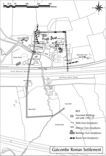
As is often the case, the geophysical surveys have raised more questions than they answered. The effort to trace the walls of the settlement suggests a defended area in excess of 14 ha, an area similar to Roman Ilchester (13 ha), which raises the question as to the function and possibly the status of the settlement ( fig. 9; online fig. 7).
Summary plan showing interpretations from all surveys.

Evidence from earlier excavations of Iron Age occupation, a roundhouse and Iron Age pottery, together with the Roman coin finds, suggests continuity of occupation through the Roman period. Geophysical evidence for extramural buildings may indicate an earlier phase of occupation before the walls were built in the third century, but excavation is required to determine this. Finds of coins of Arcadius minted in the early fifth century with evidence of wear and worn out and repaired floors all indicate occupation continuing into the fifth century for an unknown period before the site was abandoned and lost. The ‘Chi-Rho’ graffiti from the settlement, and possibly the presence of burials within the defences, could provide some evidence for Christianity in the post-Roman period.
The position of the settlement in the landscape suggests a natural prestige site, and it must be questioned as to whether the site really is as isolated away from a major Roman road as has been suggested previously. Margary notes two segments of road (545 and 546) on the natural route for a road linking the Fosseway south of Bath with the Bristol Channel ports at Portishead and Portbury.Footnote 137 This may suggest that Gatcombe is sited on a crossroads, with a now lost road linking the site with Roman Britain's principal highways. This would make sense if the settlement were involved in the taxation system in the fourth century, as perhaps indicated by the number and denomination of fourth-century coins.Footnote 138 However, features that would indicate such status — including the presence of major buildings, a planned road system etc. — have yet to be identified. What is clear is that the site had been abandoned by the eighth century with no evidence of Anglo-Saxon occupation having been found to date.
This site is clearly of some importance whatever its status — settlement, town or religious enclave — but this will remain unresolved without further investigation and excavation.
SUPPLEMENTARY MATERIAL
For supplementary material (online figs 1–7) showing the results of the geophysical surveys please visit http://journals.cambridge.org/bri
ACKNOWLEDGEMENTS
This paper is dedicated to the memory of Keith Gardner whose untimely death interrupted his lifetime interest in the site. We hope that he would have been delighted with the results of these investigations. We owe grateful thanks to Stella Clarke, William and Henry Butler for their support and permission to access their land; Dr Stuart Prior and Dr Jaqueline Wilson (University of Bristol); Professor Keith Branigan and Vince Russett (North Somerset's Archaeologist) for their help and advice, and all the members of the Gatcombe Environs Research Team (GERT) for their hard work, and turning out in all weathers to help with this research project.