NORTH OF THE ANTONINE WALL
PERTH AND KINROSS
(1) Haughend (NO 287 470): excavationFootnote 6 revealed 19 keyhole-shaped field ovens in two main clusters (of five and eight respectively), the others being more scattered. The work also revealed long stretches of a shallow V-sectioned ditch (up to 0.8 m wide × 0.46 m deep) which turned through a right angle, reminiscent of a camp ditch, although the rather loose fill, small size and presence of modern intrusive material in the base in one area, along with the absence of any entrance in a stretch of 300 m, suggested to the excavators that it was more recent field boundary.Footnote 7 Its rounded corner is unusual for that, however, and it remains possible that more recent ditches reused a visible Roman line. The ovens were mostly contained within the ditch, but some lay beyond it. The site lies immediately over the River Isla from the fort at Cardean, providing a ready context for the activity.
THE ANTONINE WALL
WEST DUNBARTONSHIRE
(1) Carleith (NS 48059 72984): geophysical surveyFootnote 8 confirmed the location of the fortlet suspected at the site,Footnote 9 measuring some 26 m wide over its ramparts; the line of the Antonine Wall Ditch in the vicinity was also confirmed.
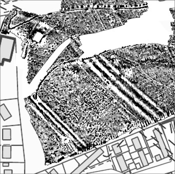
(2) Golden Hill, Duntocher (NS 495 727): geophysical surveyFootnote 10 confirmed the presence of a triple ditch system in front of the fort and annexe (fig. 1), suggesting the site was laid out as a larger fort and later subdivided.Footnote 11 The only access across these ditches was via the gateway of the original fortlet.
Greyscale plot of processed gradiometer data from survey at Golden Hill, Duntocher. (© Historic Environment Scotland, courtesy of Nick Hannon)

CITY OF GLASGOW
Balmuildy, East Balmuildy farm (NS 582 717): excavationsFootnote 12 to assess damage to the east annexeFootnote 13 caused by unauthorised development located the fort's outer ditch and the ditch (surviving 2.4 m wide and up to 1.2 m deep) delimiting the annexe's southern side, which had been reused for a later field drain. Scattered features within the annexe produced Roman pottery and slag. Rubble from a demolished barn was checked, but no Roman stones were found.
FALKIRK
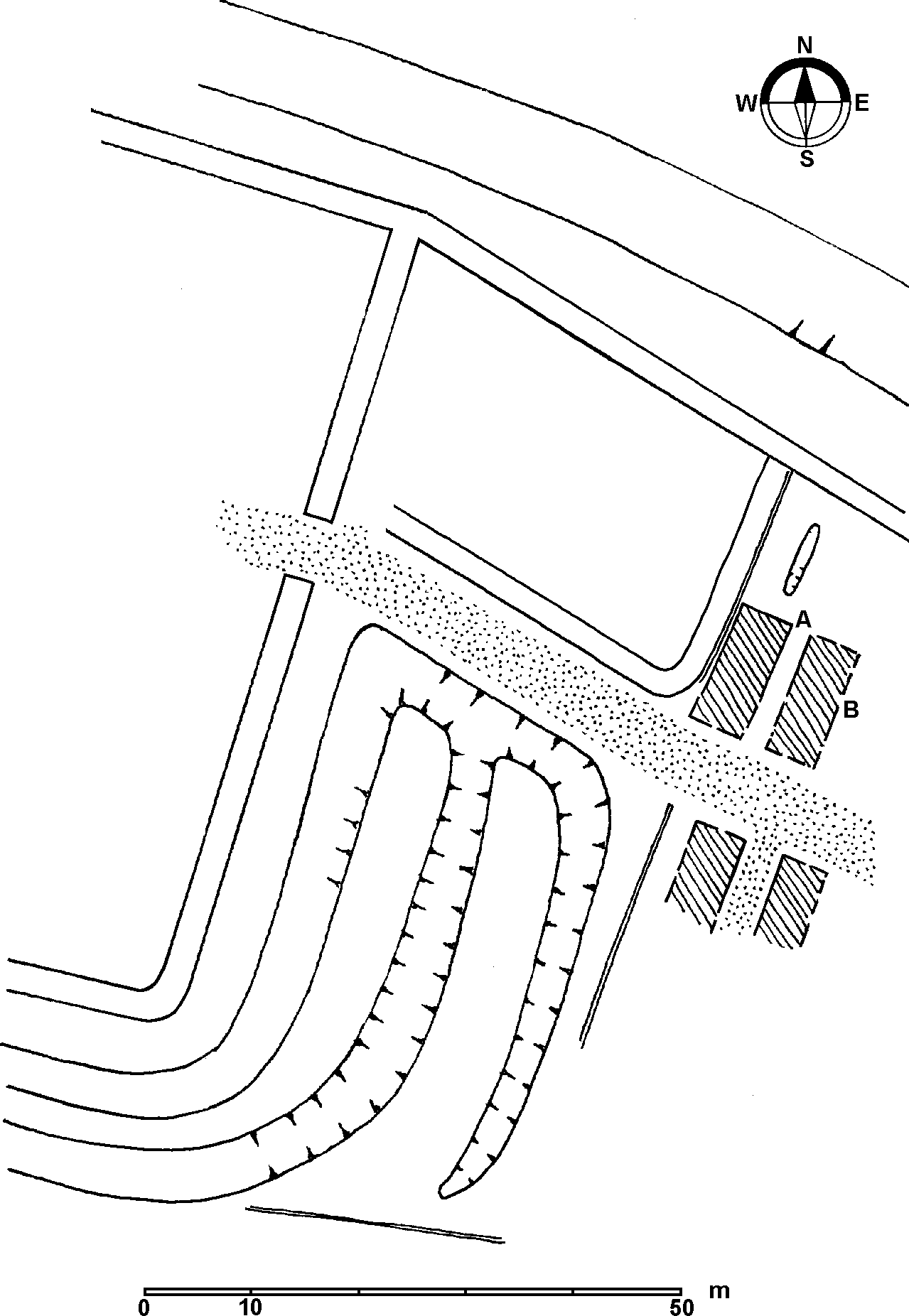
(1) Falkirk, 14 Booth Place (NS 8874 7973): a series of trenchesFootnote 14 within the garden revealed a complex sequence starting with pre-Roman ard-marks. The site lies within the eastern annexe of the fort; two strip buildings lay perpendicular to the road from the east gate, one with evidence of domestic activity, the other of iron-working. Their construction may have predated the erection of annexe defences; a narrow turf rampart and ditch to their west was subsequently erected, suggesting a small enclosure was constructed between them and the fort (fig. 2).Footnote 15 This was later backfilled (when the annexe was constructed?) and a ditch dug to separate the buildings from the Antonine Wall to the north, but the small enclosure was reinstated in a later phase when the buildings were demolished. It indicates a complex development sequence in the area.
Reconstructed plan of the area to the east of Falkirk fort in phase II, based on results from 14 Booth Place. (Courtesy of Geoff Bailey)

(2) Mumrills, Fort Knowe (NS 9180 7935): excavation in the garden of this house,Footnote 16 which lies over the fort's south rampart, confirmed the location of the south gate, with a two-phase road located immediately within the rampart. A culvert in the second phase may have acted as an aqueduct.Footnote 17 A post-Roman post-hole reused a substantial dressed stone as a packing stone.
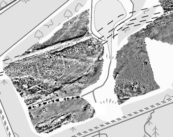
(3) Kinneil House (NS 978 804): geophysical surveyFootnote 18 confirmed the line of the Ditch from west of the known fortlet to the Dean Burn at the east end of the estate, and identified a break in it east of the house, though whether an original causeway connected to an unknown (or intended) installation or later infilling is unclear. A small square ditched enclosure some 10 m across immediately behind the rampart some 50 m east of the fortlet (NS 97821 80403) is likely to be another of the ‘minor enclosures’ known occasionally elsewhere on the Wall (fig. 3).Footnote 19
Greyscale plot of processed gradiometer data from survey of the fortlet at Kinneil (left), showing a minor enclosure to the right of it, beside the pond. (© Historic Environment Scotland, courtesy of Nick Hannon)

SOUTH OF THE ANTONINE WALL
SOUTH AYRSHIRE
(1) Girvan Mains (NX 1922 9909): among a scatter of undated and undiagnostic features within the eastern end of the eastern temporary camp,Footnote 20 excavationFootnote 21 revealed a figure-of-eight field oven consisting of a shallow circular oven with heat-reddened base attached to a deeper stoke-hole. The infilling of the stoke-hole suggests at least two phases of use.
DUMFRIES AND GALLOWAY
(1) Middlebie Hill (NY 207 765): geophysical surveyFootnote 22 recovered significantly more of the outline of the two camps partly known from aerial photographyFootnote 23 and identified a third camp set within the southwest corner of camp II. A possible road line skirting the hill to the southwest was also identified.
SUPPLEMENTARY MATERIAL
For supplementary material for this article please visit https://doi.org/10.1017/S0068113X22000393