Introduction
In a study that divided the world ocean into 232 parts and assessed the importance of 17 different anthropogenic factors in altering ecosystem function in each, Halpern and others (Reference Halpern, Walbridge, Selkoe, Kappel, Micheli, D'Agrosa, Bruno, Casey, Ebert, Fox, Fujita, Heinemann, Lenihan, Madin, Perry, Selig, Spalding, Steneck and Watson2008) indicated that the Ross Sea has been the least impacted of any open ocean, marine area on Earth. Tallying cumulative effects, the Ross Sea received a score of 0.1 compared to the highest scores, which ranged 17.0–19.5 (North Sea, certain equatorial reefs, etc). The impacting factors included widespread pollution of different sorts, artisanal fishing, alien species invasion, climate change (warming, acidification, UV), and others. In regard to commercial fishing, five types were included, but just for the five years from 1999 to 2003. Recent whaling does not seem to have been included.
The case has been made that the Ross Sea is the least affected stretch of ocean remaining on Earth, and therefore deserves protection (Ainley Reference Ainley2002, Reference Ainley2004). Since Halpern and others (Reference Halpern, Walbridge, Selkoe, Kappel, Micheli, D'Agrosa, Bruno, Casey, Ebert, Fox, Fujita, Heinemann, Lenihan, Madin, Perry, Selig, Spalding, Steneck and Watson2008) did not consider historical data for any region in their analysis (Blight and Ainley Reference Blight and Ainley2008), to substantiate that claim about the Ross Sea, a review of the history of earlier exploitation is necessary. Herein, historical and current sealing, whaling, and fishing within the Ross Sea are reviewed, and the case is made that, indeed, the Ross Sea's continental shelf foodweb has been until very recently, with the advent of a toothfish fishery, in a state much as it has been over past millenia.
Definition of the Ross Sea
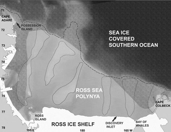
The Ross Sea, about the size of southern Europe, is defined, following the boundary identified by Davey (Reference Davey2004), as the waters overlying the continental shelf and slope extending in a wavering line, including the northward projecting Pennell Bank, from Cape Adare, Victoria Land (71°17′S, 170° 14′E), to Cape Colbeck, Marie Byrd Land (77° 07′S, 157° 54′W; Fig. 1). Not included are waters around the Balleny Islands (66° 55′ S, 163° 20′ E), which are the summits of deep-rising sea mounts, 200 km to the northwest of Cape Adare. However some authors have included this area, as well as others north of the Ross Sea shelf and slope (Anon. 2000; Waterhouse Reference Waterhouse2001; see below).
The Ross Sea showing locations mentioned in the text. The shelf break, defined as the 800 m isobath, is shown by a dashed line; banks are shown by narrow, solid lines; sea ice is shown as marbled shading in a distribution typical of early December. Discovery Inlet, an embayment in the Ross Ice Shelf that was similar to Bay of Whales, is no longer a feature, having been the product of iceberg calving in the early years of the 20th century. The Balleny Islands are well to the northwest, beyond the boundaries of this map.

The Ross Sea is shaped like a right angled triangle, with the height being the north-south oriented Victoria Land coast and the base being the east-west Ross Ice Shelf (or Barrier), extending north and east, respectively from Ross Island (77° 30′S, 168° 00′E). To be accurate, the Ross Ice Shelf covers a portion of the Ross Sea basin to the south equal in size to the open-water portion in the north. The mean depth of the exposed shelf is about 500 m, although this varies widely between deep troughs and shallow banks. The shelf break has been defined by some to occur at the level of the troughs, about 800 m, rather than the outward crest of its banks, with the slope descending to 3000 m (Smith and others Reference Smith, Ainley and Cattaneo-Vietti2007); the tops of the banks at the shelf break can be <200 m deep. Overall, the Ross Sea bathymetry slopes upward from south to north (the banks) owing to the isostatic depression of the continent from the heavy mass of the polar ice cap.
Ross Sea surface water (RSSW) is distinctive and, until recent glacial melting upstream, was the most saline surface water in the Southern Ocean (Jacobs and others Reference Jacobs, Giulivi and Mele2002). The high salinity of RSSW is related to sea ice formation, with concomitant salt rejection as the ice forms, for much of the year (Jacobs and Comiso Reference Jacobs and Comiso1989). At the Ross Sea (Antarctic) slope front, circumpolar deep water upwells and constrains RSSW to the south (Ainley and Jacobs 1981; Jacobs Reference Jacobs1991). The central portion of the Ross Sea, from ice shelf front northward, due initially to incessant winds and subsequently to warming, becomes increasingly clear of sea ice as the season progresses, from October to January. This is the Ross Sea polynya and post polynya (Jacobs and Giulivi Reference Jacobs and Giulivi1998, Reference Jacobs, Giulivi, Spezie and Manzella1999).
Biologically, the Ross Sea is divided into two components, the continental shelf (neritic) and the continental slope (pelagic). The former has as its principal, mid-trophic ‘forage species’, ice or crystal krill Euphausia crystallorophias and the Antarctic silverfish Pleuragramma antarcticum (Smith and others Reference Smith, Ainley and Cattaneo-Vietti2007). It, therefore, differs from the Ross Sea continental slope food web, dominated by Antarctic krill E. superba, a food web that was damaged in the past by the mass removal of whales (see below).
Exploitation
Sealing
Major, industrial sealing did not affect the Ross Sea. No evidence exists that fur seals (Arctocephalus spp.), the main target species of early sealers, ever bred in any numbers, if at all, in the vicinity. No specimens have ever been found along Ross Sea shores, and no reports exist noting their presence at sea in the vicinity. The closest, and virtually only location where Antarctic fur seals A. gazella could have bred and still reach the Ross Sea in any numbers would have been the very steep sided Balleny Islands. These emerged sea mounts are surrounded by sea ice for most of the year and, moreover, the Antarctic fur seal is not a ‘pack ice associated species’ (Siniff and others Reference Siniff, Garrott, Rotella, Fraser and Ainley2008). No evidence exists that fur seals ever occurred on the Balleny Islands, although they were discovered by John Balleny during a search for new sealing grounds in 1839 (Riffenburgh Reference Riffenburgh2006 I: 123–124), and there were inspections by subsequent early explorers, for example members of James Clark Ross's party who attempted to wade ashore (Ross Reference Ross1847). No evidence exists to indicate long distance migratory movement in southern hemisphere fur seals, similar for example to that which occurs in the northern fur seal Callorhinus ursinus, the females of which winter off Japan and California a few thousand kilometers from their Pribilof breeding site (for example Kenyon and Wilke Reference Kenyon and Wilke1953). Therefore, the migration of Antarctic fur seals from even the closest breeding colony, Macquarie Island (54°37′S, 158°52′E), lying slightly south of Tasmania and New Zealand, is highly unlikely.
In the case of the southern elephant seal Mirounga leonina, as late as the early 1980s after sub-Antarctic breeding populations had recovered from decimation (Laws Reference Laws, LeBoeuf and Laws1994), low numbers of subadult males hauled out for moult in a number of locations during late summer, for example Ross Island and the Victoria Land coast (Brownell and Ainley Reference Brownell and Ainley1976; Hall and others Reference Hall, Hoelzel, Baroni, Denton, Le Boeuf, Overturf and Töpf2006), as well on offshore rocks at the Balleny Islands (Riffenburgh Reference Riffenburgh2006 I: 123). No longer do they occur in the Ross Sea as the source population on Macquarie Island seriously decreased once again in the 1980s (Laws Reference Laws, LeBoeuf and Laws1994), and thus the likely density dependent foraging range of that population appears to have contracted. Assuming that a recent analysis concerning Antarctic southern elephant seal rookeries is correct (Ainley and Blight Reference Ainley and Blight2009), the decrease was due to the depletion of their fish prey in sub-Antarctic Macquarie Island's surrounding waters and shelves. Recent tracking of elephant seals from Macquarie Island indicate foraging in waters north of the Ross Sea, as defined above (McConnell and others Reference McConnell, Chambers and Fedak1992; Van den Hoff and others Reference Van Den Hoff, Burton, , Hindell, Sumnet, and McMahon2002; Hindell and others Reference Hindell, Bradshaw, Sumner, Michael and Burton2003).
The early, ‘heroic’ expeditions killed, for human and dog food, an unknown number of Weddell seals Leptonychotes weddellii in southern McMurdo Sound, but by the 1950s the population was thought to have recovered (Stirling Reference Stirling1971). In the same area, the New Zealand Antarctic Programme then killed 50–100 annually, eventually totaling about 2000 animals, in order to feed sled dogs. From 1957 to 1985; the U.S. programme killed a small (unknown) number for scientific reasons during the first few years of this period (Stirling Reference Stirling1971). The population, in the late 1950s prior to initiation of the New Zealand kill was thought to number close to 3000 individuals. It initially decreased in size, but then began to increase in a density dependent response to the kill, followed by a decrease to near 1500 by the mid-1980s when the killing ended. Relative to the Ross Sea population, this decrease was thought to be local, in McMurdo Sound, although the population is partially sustained by emigration from the greater Ross Sea. Therefore, fluctuation in some sort of density dependent emigration from outside McMurdo Sound was probably involved at times (Testa and others Reference Testa and Siniff1987).
Since the end of the seal take, the population of seals in southern McMurdo Sound recovered only slightly, now numbering around 2000. It has not recovered further owing to an ocean regime shift in the mid-1970s and changes of sea ice and/or the foodweb (Ainley and others Reference Ainley, Clarke, Arrigo, Fraser, Kato, Barton and Wilson2005).
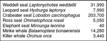
Therefore, at the large scale, the Ross Sea shelf is missing several dozen elephant seals and several hundred Weddell seals from the summer food web. A minimum of 10,000 Weddell seals currently breed (adults) along the Victoria Land coast and outlying islands, with unknown numbers also in the Bay of Whales and along Cape Colbeck (Siniff and Ainley Reference Siniff and Ainley2008). In total, including young age classes, as many as 30,000 in total may be present in the Ross Sea (Table 1). In addition, there are a few hundred thousand seals of three other species present in the Ross Sea, and which have never been exploited. Mostly they are associated with the marginal ice zone of the eastern and western Ross Sea and the continental slope (Ainley Reference Ainley, Siegfried, Condy and Laws1985, Reference Ainley2002; Table 1).
A summary of population estimates of marine mammals in the Ross Sea made on the basis of several cruises during the late 1970s-early 1980s (Ainley Reference Ainley, Siegfried, Condy and Laws1985).

Whaling
Caveats regarding Ross Sea whales
It has been proposed that while the extraction of whales, especially blue whales Balaenoptera musculus intermedia, from the continental slope of the Ross Sea was important, little whaling was carried out in waters overlying the shelf itself (Ainley Reference Ainley2002, 2003), where only minke whales B. bonaerensis, killer whales Orcinus orca and Arnoux's beaked whales Berardius arnuxii are known to occur at present (Ainley Reference Ainley, Siegfried, Condy and Laws1985; Ponganis and Kooyman Reference Ponganis and Kooyman1995; Van Dam and Kooyman Reference Van Dam and Kooyman2004) and, as will be argued below, constitute the neritic cetacean community of the past. Various persons, many privately, have questioned how whalers could have avoided the Ross Sea neritic system, as doing so seemingly would be contrary to the literature (for example Pinkerton Reference Pinkerton, Hanchet and Bradford-Grieve2007). However, a closer look at the available information (see below) indicates that very few blue, even fewer fin and certainly no humpback whales occurred over the shelf in the past or at present, unlike in adjacent waters, and in fact very few individuals of these species, if any, were ever taken from Ross Sea neritic waters (as opposed to blue whales and a few fin whales in waters of the continental slope). The subsequent industrial whaling for minke whales during the 1970–1980s was largely confined to waters north, east and west of the Ross Sea, but nevertheless the population since has recovered following the cessation of whaling in the 1980s (Branch Reference Branch2006; see below). Unlike the great whales, the Antarctic minke, owing to a major portion of the population that resides in the pack ice, was never decimated to the point of near extinction, thus challenging chances for recovery (Ainley and others Reference Ainley, Dugger, Toniolo and Gaffney2007a).
Three factors confuse the role of whaling in the potential alteration of the Ross Sea neritic ecosystem. First, the whalers separated the Southern Ocean into parts, such as Ross Sea, Amundsen Sea etc, with these designations applying to any Antarctic waters lying in the respective general vicinity (Tønnessen and Johnsen Reference Tønnessen and Johnsen1982). Therefore, based on the definition of the Ross Sea stated above, any historical reports that nebulously refer to ‘the Ross Sea’ need to be considered carefully. Until recently, even the Commission for the Conservation of Antarctic Marine Living Resources (CCAMLR) referred to the waters south of New Zealand as the Ross Sea. However, waters north of the Ross Sea shelf, being referred to by oceanographers as the Ross Gyre (Jacobs and others Reference Jacobs, Giulivi and Mele2002), are quite different as is explained above.
The second factor confusing the perception of the level of whaling in the Ross Sea pertains to a location called the Bay of Whales. The uninformed assumption is made that if whales were so numerous to have deserved the naming of a semi-permanent enclave of the Ross Ice Shelf after them (Fig. 1), then how could the mass killing of whales not have occurred there? The Bay of Whales was named by Ernest Shackleton (Reference Shackleton1909), who actually appears to have encountered a large concentration of killer whales, or at least he commented on the conspicuousness of the dorsal fins of those whales he saw (baleen whales have very small, unremarkable dorsal fins): ‘All around us were numbers of great whales showing their dorsal fins as they occasionally sounded . . . We named this place the Bay of Whales, for it was a veritable playground for these monsters’ (Shaxckleton Reference Shackleton1909: 50).
In fact, the Ross Sea is the major area where the diminutive type-C (fish eating) killer whale is found (Pitman and Ensor Reference Pitman and Ensor2003, Pitman and others Reference Pitman, Perryman, Leroi and Eilers2007), and characteristically they occur in large groups sometimes 50–100 or more, especially where fast ice is breaking up (as noted by Ross Reference Ross1847 1: 244) thus to expose littleharassed fish. Such a density of animals is quite uncharacteristic of foraging baleen whales (Kasamatsu and others Reference Kasamatsu, Ensor and Joyce1998). Roald Amundsen (Reference Amundsen1912), who based his South Pole expedition at the Bay of Whales, concurred with Shackleton, but also seems likely to have been referring to these killer whales, at least judging from their numbers: ‘The name of the Bay of Whales . . . is appropriate enough; for from the time of the break-up of the sea-ice this huge inlet in the Barrier forms a favorite playground for whales, of which we often saw schools of as many as fifty disporting themselves for hours together’ (Amundsen Reference Amundsen1912: 273). This is the behaviour and group size of type-C killer whales (Pitman and Ensor Reference Pitman and Ensor2003; Pitman and others Reference Pitman, Perryman, Leroi and Eilers2007; Ainley, personal observation).
Ross (Reference Ross1847) had visited what became known as the Bay of Whales in 1841 and 1842 and, although he wrote extensively of the whales seen during his two voyages to the Ross Sea, especially where large numbers were encountered, he made no mention of whales there or within the several days he explored the barrier front. His cruises were late in the season, well after the ice had broken out of the bay. Other subsequent visitors to the Bay of Whales, including three in the last 20 years (Ainley Reference Ainley, Siegfried, Condy and Laws1985; Ainley and others Reference Ainley, Dugger, Toniolo and Gaffney2007a), as well as that of the factory ship James Clark Ross, which tied up there for several weeks during the 1923 and 1924 whaling seasons (Barr and Watt Reference Barr and Watt2005), encountered no whales nor any in the nearby Discovery Inlet (Fig. 1). In fact C.A. Larsen commented specifically on this disappointment (Barr and Watt Reference Barr and Watt2005: 288).
The final item fostering lack of clarity in our understanding of the historical occurrence of whales in the Ross Sea is the assumption that the early explorers were knowledgeable about species identifications (Barr and Watt Reference Barr and Watt2005). In fact, rarely did any of the explorers of the heroic age mention whales by species in their logs, and in a number of cases they appeared to be incorrect. For instance, according to Amundsen (Reference Amundsen1912): ‘. . . we did not receive the impression that there was any very great number of them [whales] out in Ross Sea. The species most commonly seen was the Finner; after that the Blue Whale’ (Amundsen Reference Amundsen1912: 274).
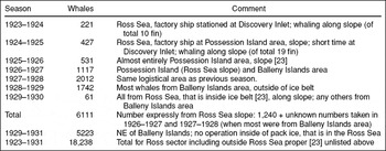
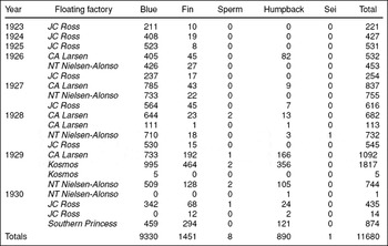
This is a most curious conclusion given the fact that of the 648 whales taken from the Ross Sea (slope; see below) during the first two years of whaling a decade later (1923–1924), only 29 were fin whales (B. physalus) and the vast majority were blue whales. In subsequent years, in the region, blue whales taken outnumbered fins 10 to 1 (Tables 2, 3). In Amundsen's case, and in others, these explorers were probably seeing minke whales, which like fin whales are black and are numerous in the Ross Sea (see below); they referred to them as ‘finners’. For instance, Ross: ‘. . . a great many whales of small size’ (Ross Reference Ross1847 1: 231); “A great number of whales of two different kinds were seen, the larger kind having an extremely long, erect back-fin [killer whale], whilst that of the smaller species was scarcely discernible” (p.244); “A few whales of the ‘finner kind’. . . In the evening ‘many whales were seen’” (vol. 2, p.145; see above, blue: fin ratio); “. . . a few whales and some finners were also seen during the day (p.195); “. . . but the small fin-backed whale, as also the piebald kind [blue], were numerous along the pack edge” (p.209).
Summary of information from Tønnessen and Johnsen (Reference Tønnessen and Johnsen1982; their Table 25 and text) with annotations. All numbers, except as noted, for the last total listed and for any whales taken in Balleny Islands area, are of blue whales (see Table 3).

Whales taken during historical times from the Ross Sea sector of the Southern Ocean; information contained in the IWC database, courtesy T.A. Branch; compare Table 2 for specifics of locations within this sector.

Historical occurrence and take of whales in the Ross Sea; ‘heroic’ expeditions
From the quotations above it is clear that minke whales, along with killer whales, were abundant in the inner Ross Sea during historical times, and that blue whales and minke whales were abundant along the slope. According to D.G. Lillie (1912), biologist on Scott's ship Terra Nova: ‘It is true that only about three species of whalebone whales were recognised south of the pack, but the number of individuals seen daily around the ship was very great. The two commonest species seen were Balaenoptera Sibbaldi, the Blue Whale, and Balaenoptera rostrata, the Pike Whale’ (Lillie 1912: 481).
The third species is the killer whale, and Lillie (Reference Lillie1915: 120) later revised his assessment, saying that ‘undoubtedly the commonest cetacean in the Ross Sea’ was the killer whale, seen almost every day, with minke whale the second most abundant. In support of this revision, Lillie (Reference Lillie1915) logged the location of whale sightings over the shelf and slope, respectively, as follows: killer whale, 17 and 0 (but he stated that they were too numerous to log regularly); minke whale, 16 and 8; and blue whale, 5 and 3. The cruises included in his report, both that of Discovery (using E. Wilson's notes) and of Terra Nova, mostly steamed through shelf waters along the Victoria Land coast (one episode along the ice barrier) and spent relatively little time crossing the slope. This cruise pattern would affect perceptions of relative abundance (see below). Scott (Reference Scott1913) further wrote of killer whales that they were ‘. . . less common in the pack but numerous on the coasts’ (Scott Reference Scott1913: 52); and Ponting photographed some apparent type-B killer whales and wrote a description of killer whales pursuing a Weddell seal and its pup (Savours Reference Savours1975). Lillie (Reference Lillie1915) reported no confirmed sightings of fin, sperm Physeter macrocephalus or humpback Megaptera novaeangliae whales in waters over the shelf or slope, though they were logged further north.
Lillie (Reference Lillie1915) recorded the position of sightings of five blue whales in shelf waters, all spaced regularly, very close to and along the front of the Ross Ice Shelf. These appear to be somewhat anomalous occurrences as, today, top trophic species of any kind are scarce in these waters (Ainley Reference Ainley, Siegfried, Condy and Laws1985) and there is no Antarctic krill, which is considered a key attribute of this whale species’ distribution in the Antarctic (see below). Thus, what these whales were doing is unclear but it is reasonable that they were not feeding. It is possible that these were multiple sightings of the same individual(s).
In regard to the overall distribution of cetaceans, it is very much evident in the logs of Ross, who noted many whales in slope waters but specifically mentioned a major decrease when plying waters to the south over the shelf, except in the bordering pack ice (which he tried to avoid). As noted above, Ross reported only the small, fin-back whale (minke) and the killer whale in southern, shelf waters. This pattern corresponds with that seen in modern times, elaborated upon below, that is whales mainly frequenting the marginal ice zone surrounding the eastern, northern and western border of the Ross Sea polynya (Ainley Reference Ainley, Siegfried, Condy and Laws1985; Karnovsky and others Reference Karnovsky, Ainley, Lee, Smith and Barber2007).
Industrial Whaling
Further information about historical occurrence patterns of whales can be gleaned from the whaling that soon followed the heroic expeditions. In the first year of Ross Sea whaling, 1923, after finding no whales in the Bay of Whales, the factory ship James Clark Ross left anchorage in its protected waters and with its five catcher boats steamed north (Barr and Watts Reference Barr and Watt2005: 289). ‘By 8.00 p.m. the small flotilla was clear of this belt of ice [at Bay of Whales] and was again steaming across the ice-free waters of the Ross Sea. Just after they left the ice-edge a number of spouts were seen, but to everyone's disgust they were soon identified as those of Minke whales. . . But early next morning (28 December) numbers of heavy spouts were sighted on the horizon and all the catchers raced off in pursuit.’
Position data showed these latter whales, blues, to be along the Ross Sea slope. Again and again this pattern is repeated in explorer and whaler logs: large numbers of whales over the slope. The flensers on board James Clark Ross complained of working in those slope waters owing to the swell and thus in the end the factory ship often had to remain in Bay of Whales or Discovery Inlet, thereupon having the catchers bring the whales from afar. Larsen noted several times that this slowed operations greatly owing to the long distances that the whales had to be towed (up to 65 km mentioned in one passage) (Barr and Watt Reference Barr and Watt2005).
By the next season, these whalers had deduced the pattern of whale movement, and had also determined the strategy to hunt the whales in the pack ice along the slope (Tønnessen and Johnsen Reference Tønnessen and Johnsen1982: 351): ‘This successful catch was in actual fact the first ice catching on a large scale in the Antarctic, revealing all the necessary criteria: the floating factory was not anchored up or moored to the shore, and catching operations were not carried out in the ice-free Ross Sea, but in the open water between the ice floes.’
Eric Marshall (Reference Marshall1930), on the factory ship C.A. Larsen, in the final year of the (true) Ross Sea whaling (1929–1930) noted, with map to illustrate, that the blue whales were taken on the northward side of an offshore ‘bank’. In fact, the northern edge of this bank, now known to be several banks running southwest to northeast, constitutes the shelf break (Fig. 1).
The early history of ‘Ross Sea’ whaling is summarised in Table 2, which gives an idea of the abundance, species composition and distribution of the species that were hunted. In the first year, the effort was entirely contained in the central portion of the Ross Sea slope (all blues, a very few fin whales), with the single factory ship stationed from time to time at the Ross Ice Shelf. In the next two years, almost all of the effort occurred in the vicinity of Possession Island (Fig. 1), at the extreme western end of the Ross Sea shelf break (almost all blues, a few fins). In the next three years, with two then three factory ships added (Table 3), the effort shifted farther west to the waters off Adélie Land (Balleny Islands), but still in the Ross Sea ‘sector’ (blues, fins, humpbacks and an occasional sei whale B. borealis). A final attempt was made in 1929–1930 to enter the Ross Sea for whales, that is the James Clark Ross cruise on which Marshall participated (above), but only a few were taken (blues). In the 1950s, factory ships twice attempted to whale in the Ross Sea, south of the ringing ice field, but quickly departed taking few, if any, whales (Tønnessen and Johnsen Reference Tønnessen and Johnsen1982).
In the 1926–1927 season a pattern was observed that is curious, and may not be ‘real’, but which colours perceptions of Antarctic whale occurrence even today, and is related to the relationship between ships (killer or survey) and certain whale species in regard to pack ice. In that season the James Clark Ross reached the pack ice edge on 12 December, but found the ice belt to be 1000 km wide. This was much wider than in earlier years. It took 21 days to push through but once inside they found few blue whales, no doubt because the ship was then over the shelf. The conclusion was made that the whales, like the ships, had trouble getting through the pack (!), rather than that the whales were over the continental slope, as always. The slope's pack ice cover thus hid the whales from the whalers, who had no capability to search to find them efficiently, particularly because their numbers by then were low anyway. In contrast, in the next season the pack ice belt was unusually narrow, and blue whales were found. In current years, IWC (International Whaling Commission) delegates are being challenged with acknowledging that a great many minke whales occur within the ice pack, where most survey vessels do not venture (Ainley and others Reference Ainley, Dugger, Toniolo and Gaffney2007a).
Finally, regarding southern right whales Eubalaena australis and sperm whales, Ross (Reference Ross1847) is the only person to have ever seen right whales in the southern Ross Sea sector, and in fact well north of the Ross Sea, at latitude 63° 20′S, 174° 30′E, at the north edge of the ice pack. He recorded ‘. . . a great many whales, chiefly common black kind, greatly resembling but said to be distinct from the Greenland whale; sperm as well as hunchbacked also observed” (Ross Reference Ross1847 1: 169).
We can only assume that Ross was familiar with this species (and not so much the others). After all he sailed extensively in the eastern Canadian Arctic where right whales once abounded, and the reason no one has since seen them in Ross Gyre waters is that they were decimated in their breeding grounds around New Zealand.
Ross also reported sperm whales in a few instances, in each case, as with Lillie (Reference Lillie1915), well north of the Ross Sea (waters of the outer slope and deeper; consistent with Nemoto and others Reference Nemoto, Okiyama, Iwasaki, Kikuchi and Sahrhage1988). The IWC database indicates that 8 were taken in the region during the 1920s (Table 3). We can assume that their numbers now, in waters north of the Ross Sea, are much reduced as their range contracted upon the population being decimated by whaling farther north (see Whitehead Reference Whitehead2000).
Modern occurrence of whales in the Ross Sea
The first modern survey of cetaceans in the Ross Sea was conducted during December and January 1976–1980 (Ainley Reference Ainley, Siegfried, Condy and Laws1985), much earlier in the season than more recent surveys. The entire Ross Sea was surveyed including pack ice covered portions (3,196 km of track), as the survey vessels were icebreakers that were following a pre-determined track in an oceanographic survey; the ice configuration was similar to that shown in Fig. 1. During this effort, 78 sightings of minke whales, numbering 153 individuals, and 6 sightings of killer whales, numbering 64 whales, were logged. Some unidentified beaked whales were seen on one occasion, very likely Arnoux's beaked whales (Ponganis and Kooyman Reference Ponganis and Kooyman1995). From these numbers, it was estimated that about 14,277 minke and 3,442 killer whales were in the Ross Sea (shelf and slope) at that time (Table 1). The killer whale result was thought to be an over estimate due to their propensity to be attracted to the survey vessel (Ainley Reference Ainley, Siegfried, Condy and Laws1985). In contrast, minke whales were wary of the ship, perhaps because whaling for them was continuing at the time (Ainley and others Reference Ainley, Dugger, Toniolo and Gaffney2007a).
These same species of whales were sighted on a cruise in May 1998 that constitutes the other seasonal extreme of Ross Sea surveys (Van Dam and Kooyman Reference Van Dam and Kooyman2004). All other cetacean surveys of the Ross Sea in recent decades have been conducted in January-February and are all IWC/IDWR-SOWER efforts (see below). The overall pattern in these surveys, similar to that observed by the early explorers, was a preponderance of cetaceans over the slope and within the marginal ice zones of the Ross Sea polynya, with very few over the central shelf (see maps in Ainley Reference Ainley, Siegfried, Condy and Laws1985; Ichii and othersReference Ichii, Shinohara, Kujise, Nishiwaki and Matsuoka1998; Karnovsky and others Reference Karnovsky, Ainley, Lee, Smith and Barber2007).
In regard to blue whales, on the basis of all available catch, sightings, strandings, Discovery marks and recoveries, and acoustic recording data in the Southern Ocean, it has been concluded that ‘Blue whales were generally associated with waters deeper than continental shelves. Shallow-water records were typically from regions with narrow continental shelves. . .In the Antarctic, they were most common on deep continental slopes’ (Branch and others Reference Branch, Stafford, Palacios, Allison, Bannister, Burton, Cabrera, Carlson, Galletti Vernazzani, Gill, Hucke-Gaete, Jenner, Jenner, Matsuoka, Mikhalev, Miyashita, Morrice, Nishiwaki, Sturrock, Tormosov, Anderson, Baker, Best, Borsa, Brownell, Childerhouse, Findlay, Gerrodette, Ilangakoon, Joergensen, Kahn, Ljungblad, Maughan, Mccauley, Mckay, Norris, Rankin, Samaran, Thiele, Waerebeek and Warneke2007: 136–137).
Given that the Ross Sea shelf is the broadest in the Southern Ocean, this statement, therefore, is exactly consistent with the story outlined above. These authors’ maps show no blue whales taken from or seen in the neritic waters of the Ross Sea and few even on the outer shelf, except for a tiny ‘island’ of catches just to the east of Ross Island at the western end of the barrier. This must be a record of catch processing and not capture, as in modern times very few whales of any kind are seen in this locality. The waters there have a food web that does not generate high krill or forage fish densities (Ainley Reference Ainley2007; Smith and others Reference Smith, Ainley and Cattaneo-Vietti2007) and certainly not E. superba, the other attribute of habitat identified by Branch and others (Reference Branch, Stafford, Palacios, Allison, Bannister, Burton, Cabrera, Carlson, Galletti Vernazzani, Gill, Hucke-Gaete, Jenner, Jenner, Matsuoka, Mikhalev, Miyashita, Morrice, Nishiwaki, Sturrock, Tormosov, Anderson, Baker, Best, Borsa, Brownell, Childerhouse, Findlay, Gerrodette, Ilangakoon, Joergensen, Kahn, Ljungblad, Maughan, Mccauley, Mckay, Norris, Rankin, Samaran, Thiele, Waerebeek and Warneke2007) as being critical to blue whale occurrence in the Southern Ocean. In any case, these cases are a few blue whales (see also Lillie observations, above). Finally, Branch and others (Reference Branch, Stafford, Palacios, Allison, Bannister, Burton, Cabrera, Carlson, Galletti Vernazzani, Gill, Hucke-Gaete, Jenner, Jenner, Matsuoka, Mikhalev, Miyashita, Morrice, Nishiwaki, Sturrock, Tormosov, Anderson, Baker, Best, Borsa, Brownell, Childerhouse, Findlay, Gerrodette, Ilangakoon, Joergensen, Kahn, Ljungblad, Maughan, Mccauley, Mckay, Norris, Rankin, Samaran, Thiele, Waerebeek and Warneke2007) noted that blue whales occur in conjunction with oceanographic fronts, and in the Ross Sea, the slope front constitutes an area frequented by Antarctic krill and vast bird numbers (Karnovsky and others Reference Karnovsky, Ainley, Lee, Smith and Barber2007). It is a very rich area.
Similarly, a summary of all sighting and capture data for blue, fin and humpback whales for IWC areas III-VI (40°E–150°W), for 1987–2004, reported only three blue whales over the northwestern Ross Sea shelf (Matsuoka and others Reference Matsuoka, Hakamada, Kiwada, Murase and Nishiwaki2008). The capture data reported was also consistent with the story above: these whales do not and did not occur over the Ross Sea shelf in any numbers (blue), if at all (fin, humpback). In the case of the last species, the pattern is consistent with that described by others (Branch Reference Branch2009): none in the Ross Sea, shelf or slope, but large numbers off the Adélie Land coast.
Finally, IWC surveys for minke whales (made in open water) indicate them to be abundant in the eastern and western Ross Sea, along the edge of the pack ice, as well as along the slope; few have been found in the south-central Ross Sea (along the Ross barrier) (Ichii and others Reference Ichii, Shinohara, Kujise, Nishiwaki and Matsuoka1998; Konishi and others Reference Konishi, Tamura, Zenitani, Bando, Kato and Walløe2008). On the basis of existing documentation from ice breaker type survey vessels (Ainley Reference Ainley, Siegfried, Condy and Laws1985; Ainley and others Reference Ainley, Dugger, Toniolo and Gaffney2007a), many more would be within the pack ice of the polynya's marginal ice zone.
Since the end of industrial whaling, the minke whale, having not been decimated plus the fact that a significant residual portion of the population frequented the pack ice where whaling ships had difficulty operating (see above) appears to have recovered (Branch Reference Branch2006). At least, that is, their numbers in the Southern Ocean had reached an asymptote, as indicated by IDCR-SOWER survey results. During the first (1985/86–1990/91) and second (1978/79–1983/84) circumpolar surveys, respectively, 786,000 and 645,000 whales were estimated, which are similar estimates when one takes into consideration the proportion of the Southern Ocean surveyed during the respective surveys. During the most recent survey, however (1991/92–2003/2004), the estimated minke whale numbers (at least in open waters) became much lower (338,000), a state of affairs that has brought much discussion.
Based on IWC abundance estimates by small geographic areas in the most recent circumpolar survey (1991–2003), a population of 21,000 minke whales is estimated for the Ross Sea (T.A. Branch, personal communication, 8 March 2007), including the shelf and slope (but of course any within the pack ice would not have been surveyed). Therefore, this represents an appreciable population increase from the days of minke whaling of the 1970s–early 1980s (see Table 1). It is highly likely that minke whales increased their numbers and expanded into the slope habitat when blue whales were removed in the 1920s. Given density dependent factors they would not be expected to have increased over the shelf, around the periphery of which they already resided. If and when blue whales recover, we might expect them again to frequent slope waters and for minke whales to decrease there. Indeed, in general, minke whales have significantly decreased as the great whales have increased; specifically, this is the most apparent in IWC areas IV and V, the two areas that have shown a dramatic increase in humpback whales (compare Branch Reference Branch2006, Reference Branch2009). Humpback and minke whales have been shown to be strong competitors (Friedlaender and others Reference Friedlaender, Lawson and Halpin2008). Blue whales are far too few for analogous studies to be undertaken at present.
Modern Whaling
During the 1970s and 1980s, until the cessation of industrial whaling in 1986, whalers took approximately 19,500 minke whales from IWC areas V and VI; the waters off Adélie Land and Ross Sea ‘sector’ (Brown and Brownell Reference Brown and Brownell2001). It is thought that upon the demise of its larger competitors, the Southern Ocean minke whale population had increased overall. For a discussion of possible response of minke whales to competitive release elsewhere, see Laws (Reference Laws and Llano1977) and Ballance and others (Reference Ballance, Pitman, Hewitt, Siniff, Trivelpiece, Clapham, Brownell, Estes, Demaster, Doak, Williams and Brownell2006). The minke whale's population size before whaling is unknown.
Upon the establishment of the whaling moratorium, in 1987, Japan began its ‘scientific whaling’ in waters off east Antarctica, that is IWC areas IV, V and VI. The programme sought to take a total of 440 whales per season from those areas. In portions of areas V-east and VI-west, from a current population of about 21,000 whales (see above), Japan took approximately 440 minke whales from the Ross Sea slope and 295 from the Ross Sea shelf (estimate from Konishi and others Reference Konishi, Tamura, Zenitani, Bando, Kato and Walløe2008: Fig. 1). In the last two seasons, 2006–2008, Japan increased its intended take of minke whales in areas IV, V, and VI to 1,000 whales from the 440 per season taken in 1987–2006. The number taken in the Ross Sea is not publicly known.
Industrial fishing
The world's continental shelves have largely been depleted of fish, especially demersal species (Hilborn and others Reference Hilborn, Branch, Ernst, Magnusson A., Minte-Vera, Scheuerell and Valero2003; Frank and others Reference Frank, Petrie and Shackell2007). This is true even in the Antarctic. Recent documentation has shown a strong correlation between decreasing populations of fish eating penguins and pinnipeds and the over-exploitation and depletion of fish stocks on the insular shelves and slopes of low latitude Antarctic islands, including the Antarctic Peninsula (Blight and Ainley Reference Blight and Ainley2008; Ainley and Blight Reference Ainley and Blight2009). Among the data amassed from the Food and Agriculture Organization (FAO) and CCAMLR, none indicate that industrial fishing had ever occurred in the Ross Sea (Koch Reference Kock1992), until the last 12 years (Pinkerton and others Reference Pinkerton, Hanchet and Bradford-Grieve2007).
In a process reminiscent of ‘fishing down the food web’ (Pauly and others Reference Pauly, Christiansen, Dalsgaard, Froeser and Torres1998), led by New Zealand, CCAMLR initiated a programme under which the Antarctic toothfish Dissostichus mawsoni biomass will be reduced by 50% from pre-exploitation levels within 35 years, beginning in 1996 (Pinkerton and others Reference Pinkerton, Hanchet and Bradford-Grieve2007). In 1996, an ‘experimental’ fishery began when New Zealand vessels extracted 1 mt, growing to 745 mt by 1999 (data from CCAMLR 2008). Some portion of this catch was from seamounts north of the Ross Sea. In 2000 no longer an experimental fishery, vessels from other countries joined, along with illegal vessels. Once CCAMLR raised the allowable catch from ~2500 mt to ~3500 mt in 2002, vessels from more than 10 countries were attracted and the catch began to meet the quota. CCAMLR believes that as of 2007, and based on the legal take, a 15% reduction in pre-fished biomass has already been achieved (Pinkerton and others Reference Pinkerton, Hanchet and Bradford-Grieve2007).
Although the catch per unit effort in the fishery has not shown any signs of depletion, it is no longer possible to catch adult fish in the southernmost reach of the Ross Sea shelf, in McMurdo Sound, judging from a record that spans 35 years, 1971–2006. Decreases are already evident in the prevalence of toothfish eating killer whales (DeVries and others Reference DeVries, Ainley and Ballard2008). In the DeVries and others study more than 4,000 fish were tagged and released, with a few dozen taken over the years for physiological studies.
Final thoughts
The foodweb of the Ross Sea continental shelf, unlike that of the slope, appears to have been largely untouched directly by humans up until the past 10 years. There are fewer elephant seals, formerly rare in the Ross Sea, and fewer Weddell seals in McMurdo Sound (~5% of the shelf area). The cetacean fauna appears to be much as it has been since James Clark Ross first sailed into these waters in the 19th century. It is highly likely that minke whales increased their numbers and expanded into the slope habitat when blue whales were removed in the 1920s, but given density dependent factors they would not be expected to have increased over the shelf where they were already resident. If and when blue whales recover, we might expect them again to frequent slope waters and for minke whales to decrease there.
One major caveat to the apparent near pristine nature of the Ross Sea shelf ecosystem exists. It is possible that the large take of minke whales, especially in pelagic waters north and west of the Ross Sea (IWC area V, VI), during the 1970s – early 1980s (see above), may have facilitated, along with climate driven changes in Ross Sea polynyas, the increase of Adélie penguins Pygoscelis adeliae in the Ross Sea at that time (Ainley and others Reference Ainley, Ballard, Ackley, Blight, Eastman, Emslie, Lescroël, Olmastroni, Townsend, Tynan, Wilson and Woehler2007b). With the cessation of industrial whaling, the penguin increase leveled off. Recent work has shown that the penguins and these whales are direct trophic competitors (Ainley and others Reference Ainley, Ballard and Dugger2006), and that Ross Sea penguins spend their non breeding season in the area from which most of the whales were removed, that is north of the Ross Sea near the large scale pack ice edge (Ballard and others in review). This would seem to be, therefore, the major anthropogenic influence so far in altering the Ross Sea neritic foodweb: more penguins in response, partially, to fewer whales in waters of the penguins’ non breeding grounds.
It should be noted that this was a case of intense industrial extraction occurring at a time of rapidly changing climate (Ainley and others Reference Ainley, Clarke, Arrigo, Fraser, Kato, Barton and Wilson2005) and, therefore, it is no longer possible to determine the relative importance of either factor to explain the penguin trends. This is the state of affairs currently for most of the Southern Ocean, in which many populations are decreasing or recovering from heavy exploitation (see reviews in Ballance and others Reference Ballance, Pitman, Hewitt, Siniff, Trivelpiece, Clapham, Brownell, Estes, Demaster, Doak, Williams and Brownell2006; Koch Reference Kock1992; Ainley and Blight Reference Ainley and Blight2009). Without protection from further industrial fishing and whaling, the Ross Sea neritic foodweb is expected to exhibit the sorts of trophic cascades that have been seen elsewhere as stocks of top trophic, long lived, slow to mature, and slow to reproduce minke whales and Antarctic toothfish are depleted (see review in Baum and Worm Reference Baum and Worm2009). If these cascades are allowed to happen, the Ross Sea's trophic structure would no longer provide an example of how Earth's cold-water, neritic food webs once functioned nor would it remain a laboratory in which the effects of climate change could be investigated without other factors confusing or masking climate effects.
Acknowledgements
This paper was prepared under NSF grant OPP 0440643, but the thoughts expressed are not necessarily those of the National Science Foundation. The paper was greatly improved by the comments of T.A. Branch, R.L. Brownell and P. Penhale. The first and second persons named also provided access to International Whaling Commission databases. I thank them for their help.