

Introduction
On March 11, 2011, a magnitude 9.0 sub-oceanic earthquake struck the Tohoku region of Japan at 2:46 PM Japan Standard Time. This initiated an unprecedented natural disaster, including the initial earthquake, followed by a massive tsunami and secondary nuclear accident at the Fukushima Daiichi nuclear power plant.1-3 The fear of radiation contamination initially hampered dispatch of medical relief teams to the Fukushima area. This is a report of the application of a geographic information system (GIS) to help determine when to deploy Japanese Medical Association Teams (JMAT) to the Fukushima disaster zone.
The mission of JMATs, as opposed to Disaster Medical Assistant Teams (DMATs), is to provide medical support for evacuees in shelters and hospitals, forensic work, public health work, and mental health care, from the acute to the chronic phase.Reference Ishii4, Reference Ishii, Nagata and Aoki5 During the immediate acute phase of the disaster, the Ministry of Health, Labor and Welfare deployed DMATs to oversee healthcare. As DMATs were being withdrawn, the Japan Medical Association (JMA, the largest professional organization in Japan, with approximately 166,000 physician members) began to dispatch a large number of JMATs to the disaster area.
A JMAT physician representative had been deployed to the city of Iwaki (population 340,000) in Fukushima Prefecture on March 13th, as an advance member of a JMAT, for rapid assessment and collection of the latest information. Iwaki, the second largest city in the disaster-affected area, is located about 200 km north of Tokyo, and 40 km south of the Fukushima Daiichi Nuclear Power Plant. As with other cities on the coastline of the Tohoku region, Iwaki was devastated by the earthquake and subsequent tsunami.
Due to radiation contamination caused by hydrogen explosions at the Fukushima Daiichi (Unit 1 on March 12th and Unit 3 on March 14th), people within a 20-km radius of the power plant were ordered to evacuate the area. The government and Tokyo Electric Power Company did not provide appropriate information, which created fear and distrust among citizens.
Amid the severe shortages of water, food, gasoline, and medical supplies, as well as uncertainty about the degree of radiation contamination, the decision to send JMATs to the Fukushima area was quite challenging. Further, an announcement made on March 17th by the U.S. Department of State that United States citizens should not stay within an 80-km radius of the Fukushima Daiichi nuclear plant exacerbated anxiety among people living in that area.
Report
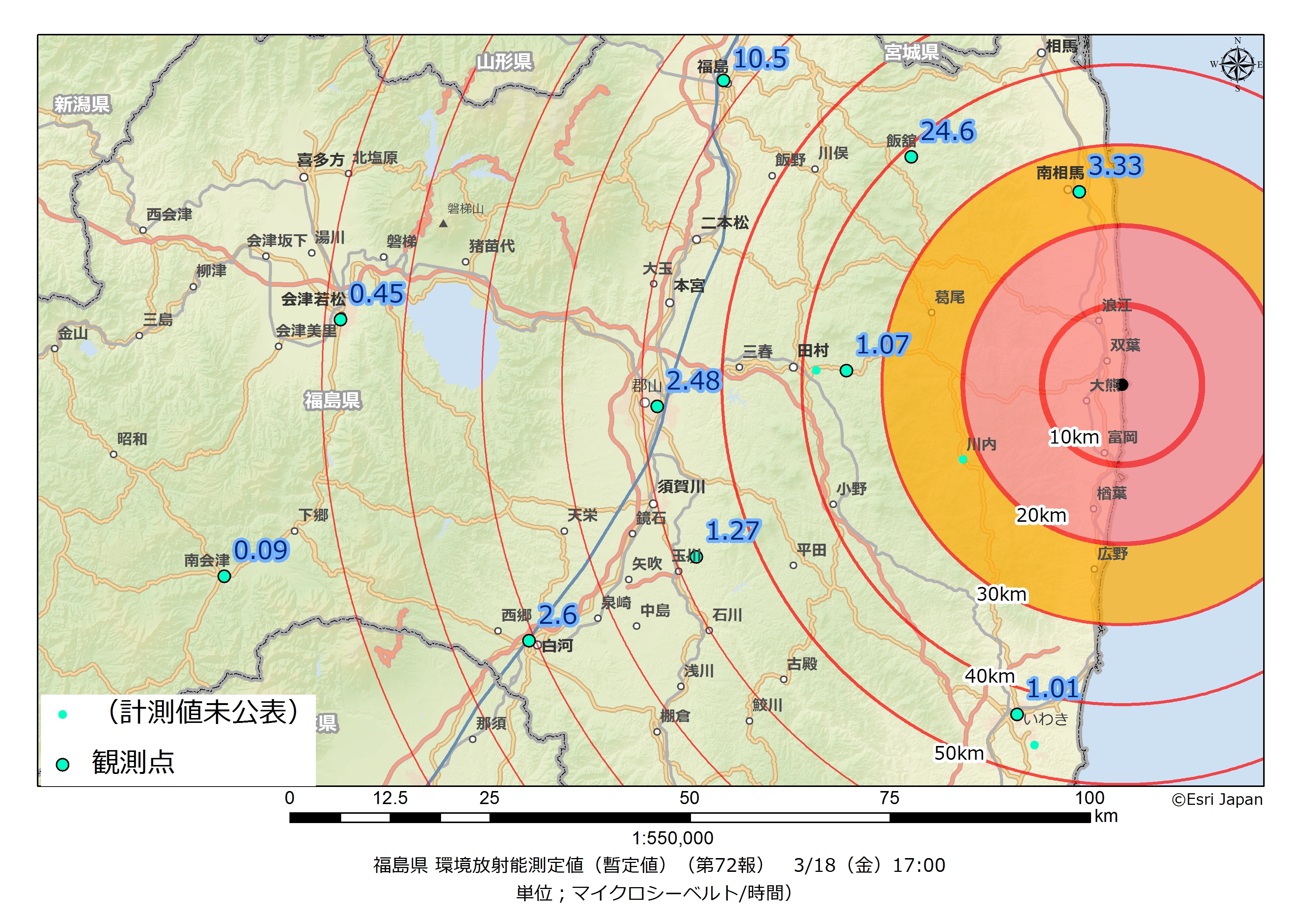
On March 18th, radiation measurements in the Fukushima area were mapped (Figure 1) using ArcGIS Desktop 10 software (Environmental Systems Research Institute, Redlands, California, USA). Data measured by local governments were updated continuously using web-based interfaces. The mapping allowed visualization of the risk of radiation, and helped the Japan Medical Association address the timing of JMAT deployment based on that data.
(Color online) Fukushima Prefecture radioactivity measurement value (provisional value) on March 18, 2011, 5:00 PM (unit = microsievert/hour)
Mapping revealed that radiation in the Fukushima area was not dispersed in a concentric fashion; the extent of contamination depended on the type of radiation, wind, rain, and land geography. Due to rain patterns, radioactive isotopes were carried by the wind from the Daiichi nuclear plant to the Abukuma highlands, and then accumulated on the ground beyond a 30-km radius. This radiation dispersal affected areas such as the village of Iitate and the city of Fukushima. The data also showed that the amount of radiation was relatively low in the city of Iwaki, located south of the Daiichi nuclear plant. This data provided assurance that short duration operations by JMATs in these areas, where low levels of radiation were detected, likely would not harm the team members.
The radiation mapping was available on the JMA website beginning March 19th (it is still updated daily on the website of the Iwaki Medical Association) so that JMAT members could evaluate the risk of radiation exposure. This mapping of radiation measurements was the first reported practical use of GIS software in the early stages of disaster management. With the support of GIS-based radiation exposure risk mapping, 273 JMATs were initially dispatched to provide healthcare support in the Fukushima area; a total of 1,394 JMATs were deployed to the disaster-affected areas by July 15th.
In Fukushima Prefecture, attempts were made to use GIS to map digitally the locations of shelters and the number of evacuees during the acute phase, aiming for effective and efficient surveillance and public health assessment by JMATs. However, this effort was not effective because of the rapidly deteriorating situation at the Fukushima Daiichi nuclear plant, with people relocating many times, in as short a time span as 24 hours. For example, when a team arrived to assess a large public gym where more than 1,000 evacuees were reportedly housed, it was found to be empty. This is consistent with previous reports describing the difficulties in applying GIS to the acute phase of a medical disaster response.Reference Harrison, Harrison and Smith6-Reference Reddick8 It was especially difficult to follow population movements in the acute phase of the disaster in Fukushima because the earthquake, tsunami, and nuclear power plant disaster occurred at the same time.9 Some people were evacuated to neighboring prefectures, while others were evacuated to points further away. To track these movements accurately would have required data updates every few hours.
Conclusion
Using GIS to map radiation measurements enabled medical relief teams to be deployed effectively and safely. However, mapping information regarding shelters and evacuees in the acute phase of the disaster was a challenge. The mapping of radiation measurements may be useful to help determine where to relocate people to in the acute phase of a nuclear accident, and when to return during the recovery phase.9
Abbreviations
- GIS:
Geographic Information System
- JMA:
Japan Medical Association
- JMAT:
Japan Medical Association Team
- DMAT:
Disaster Medical Assistance Team
Supplementary material
To view supplementary material for this article, please visit http://dx.doi.org/10.1017/S1049023X1200060X.