INTRODUCTION
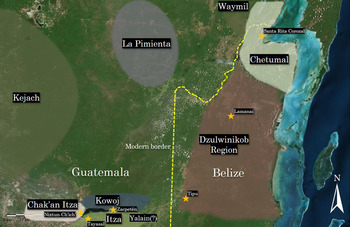
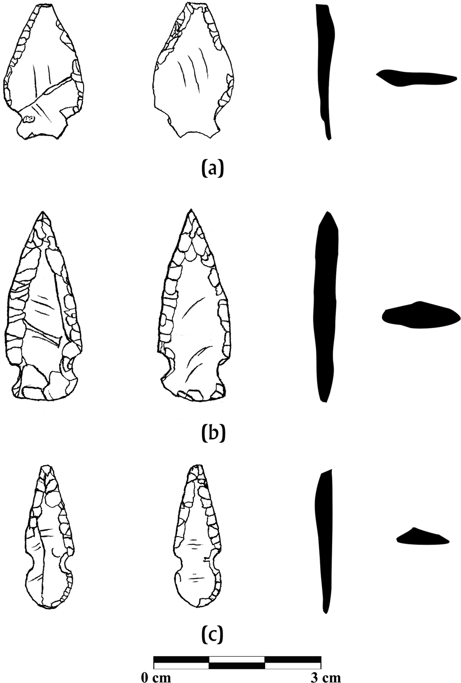
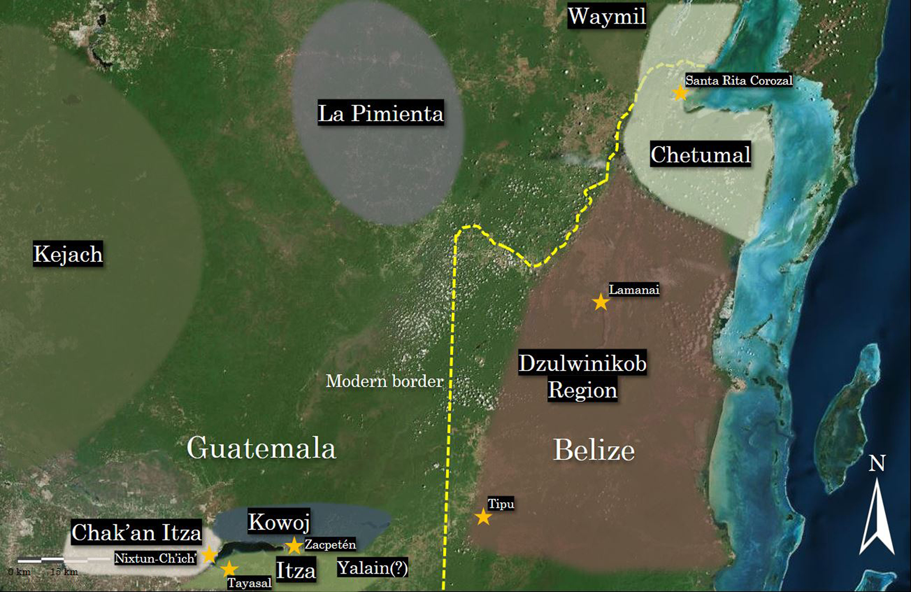
The Late Postclassic and Early Colonial periods (a.d. 1350–1525) of the Maya lowlands are typically characterized by interaction and migration during a time of shifting geo-political divisions. One subregion of interest in the lowlands is the area extending from the Peten Lakes district to the greater Rio Hondo drainage where several Maya ethnopolities resided in proximity to one another without pronounced geographical barriers (Figure 1). Maya identities or groups in Belize known as Dzulwinikob and Chetumal remain enigmatic in terms of archaeological research, and their relationships with Peten groups (known ethnohistorically as the Itza, Kowoj, and Chak'an Itza) are poorly understood. This article examines these identities from a technological perspective of projectile weaponry that includes elements of vertical (generational) and horizontal (contact-related) transfer in lithic technology. Small arrow points are a defining class of stone tool during the Late Postclassic to Early Colonial (Contact) periods (Figure 2), and have been studied at several sites in the Maya region (Aoyama Reference Aoyama2005; Blake Reference Blake2010; Graham Reference Graham and Thomas1991, Reference Graham2011; Marino et al. Reference Marino, Johnson, Meissner and Walker2016; Masson Reference Masson2000; Meissner Reference Meissner2014, Reference Meissner2017, Reference Meissner, Rice and Rice2018a; Meissner and Rice Reference Meissner and Rice2015; Oland Reference Oland2013; Proskouriakoff Reference Proskouriakoff and Pollock1962; Shafer and Hester Reference Shafer, Hester, Chase and Chase1988; Simmons Reference Simmons1995, Reference Simmons2002).
Map of the modern Peten-Belize border with approximate locations of ethnopolities, and major Late Postclassic/Colonial period sites. Modified and redrawn from Google Earth satellite imagery by the author.
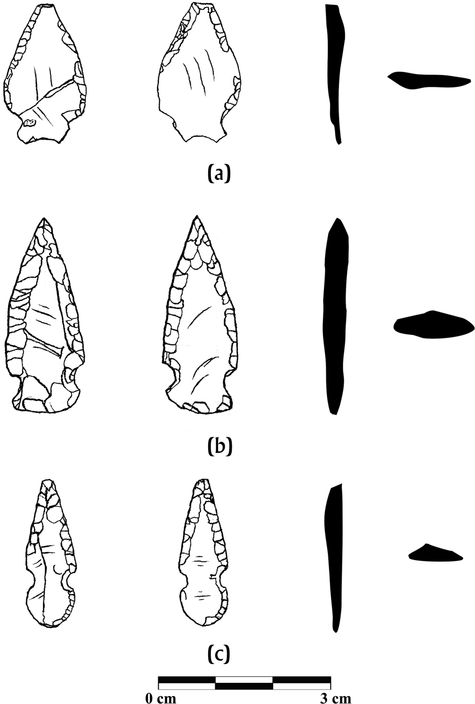
Examples of Late Postclassic/Colonial Itza points from Tayasal manufactured from chert. (a) Structure T94 (Lot #74000). (b) Structure T31 (Lot #73627). (c) Structure T94 (Lot #72526). Drawings by the author.
A major research question guiding this paper regards the nature of Maya boundaries during this turbulent time: how socially and economically integrated were Maya populations across the Peten Lakes region to northern Belize, and how can this interaction be studied archaeologically? Research on the Late Postclassic/Early Colonial period has advantages to address this question as there are historic accounts from early Spanish expeditions that shed light on Indigenous political relationships. Such accounts, however, often suffer from a lack of clarity, misunderstandings of Indigenous languages, and the motivations of early colonizers often reified Indigenous political systems for social and economic gain (Pendergast Reference Pendergast1993). Material perspectives provide a complement to such data as an alternate line of evidence to understanding past Maya boundary formation and fluidity. Thus, the methodological and theoretical constructs of Maya boundaries are examined through data from lithic tools that include macroscopic technological analysis and innovative social network analysis (SNA) applications to exchange. Such methods reveal new complexities of Late Postclassic/Early Colonial economics that have not been accounted for in current literature concerning the northern Peten-Belize subregion.
INTERPRETIVE FRAMEWORK
How might anthropological concepts of social belonging, alliance, and conflict among groups manifest themselves in the archaeological record? Answers to such questions can easily devolve into critiques of culture-historical perspectives that include old warnings about “pots equaling people” (or in this case, “points equaling people”). The identification of cultural identities, factions, or ethnicities from archaeological inquiry has long been a topic of debate (e.g., Brumfiel Reference Brumfiel, Brumfiel and Fox1994; Feinman et al. Reference Feinman, Banker, Cooper, Cook and Nicholas1989; Hodder Reference Hodder1982; Longacre and Skibo Reference Longacre and Skibo1994; Weissner Reference Wiessner1983), and some challenges arise in connecting social or political groups with their material correlates. Part of this difficulty stems from defining identities in the ethnographic present, where group features like language and culture traits do not remain consistent throughout and are often contradictory and ambiguous. Barth (Reference Barth and Barth1969:10) sought to refocus and refine methodological problems of ethnicity in anthropology by defining ethnic groups by how actors self-identify. In doing so, he downplayed aspects of descent and a one-to-one relationship between cultural traits and ethnic groups. Instead, he argued for awareness of how ethnic boundaries were socially constructed—including how identities and membership could change over time (Barth Reference Barth and Barth1969:14–15). Such redefinition adds challenges to the interpretation of the archaeological record, as archaeologists cannot “speak” to prehistoric peoples to understand an emic point of view. To approach ethnicities archaeologically, Emberling (Reference Emberling1997:311) suggests that ethnohistoric documents may begin to shed light on prehistoric social identities. From this, he proposes comparing distinctive practices and material culture with neighboring groups including a careful analysis of production and use domains. This present study suggests that material culture and the technological systems in which it is embedded are the main topics of interest for understanding past social boundaries.
From a comparative approach, analytical frameworks used by historical archaeologists can also shed light on the problem of geopolitical boundaries from an archaeological perspective. One study by Millhauser et al. (Reference Millhauser, Fargher, Heredia Espinoza and Blanton2015) examined the politics of raw material procurement in the Late Postclassic/Contact-era urban center of Tlaxcallan. The study suggested that Tlaxcalteca hostilities with Aztecs left distinct signatures in obsidian procurement of the polity. Instead of exploiting obsidian sources closest to Tlaxcallan, inhabitants exploited the Paredon source located outside of the economic and political hegemony of the Aztecs (Millhauser et al. Reference Millhauser, Fargher, Heredia Espinoza and Blanton2015:144). Outside of Mesoamerica, Liebmann's (Reference Liebmann, Liebmann and Murphy2011) work at Zia Pueblo in the American Southwest uncovered how hostilities and factionalism were manifested in ceramic assemblages following the Pueblo Revolt. In particular, economic hostilities appeared to have made Tewa wares decrease significantly during Zia conflict with the Tewa, or increase dramatically with alliances between the Tewa and Jemez Pueblo (Liebmann Reference Liebmann, Liebmann and Murphy2011:216–217). Thus, it is clear that the construction of geopolitical borders can impact particular forms of production and acquisition of material culture.
Procurement and exchange, however, are only two areas to examine the complexity of interaction and conflict. This article suggests that a technological systems approach to lithic analysis in the subregion can contribute to discussions of geopolitical borders and interaction. This approach, which includes the holistic study of production, artifacts, and use, has been fruitful for studying the complexities of cultural identities in the archaeological record (Cecil Reference Cecil2001; Ehrhardt Reference Ehrhardt2005; Kingery Reference Kingery and David Kingery1996a, Reference Kingery and David Kingery1996b). A narrow focus on attributes and material properties largely ignores crucial aspects of production and design activities that ultimately lead to cultural factors of materials acquisition, distribution (exchange activities), use, and performance. By definition, material culture must be linked with human activities and behavior. Thus, the relationships linking style, technology, and economies are critical in the interpretation of boundaries among past cultures.
BACKGROUND
The lowland Late Postclassic represents a radical reformulation of Terminal Classic polities, and is often characterized by migration, political fragmentation, and economic integration through decentralized long-distance exchange (Masson Reference Masson20000, Reference Masson, Smith and Berdan2003; McKillop Reference McKillop2005; Sabloff and Rathje Reference Sabloff and Rathje1975; Smith and Berdan Reference Smith, Berdan, Smith and Berdan2003). The magnitude and nature of this integration are subject to refinement as more archaeological data are analyzed from the central lowlands (Cecil Reference Cecil, Rice and Rice2009; Graham Reference Graham2011; Meissner Reference Meissner2017; Pugh and Rice Reference Pugh, Rice, Rice and Rice2009a; Rice and Rice Reference Rice and Rice2009, Reference Rice and Rice2018b; Schwarz Reference Schwarz2009). The region of interest for this paper includes several ethnopolities known both archaeologically and from Spanish documentation. The loose term “ethnopolity” is used to describe the nebulous groups of emic social organization of the Lowland Maya which includes ch'ib’al lineages and other forms of self-identification. Further north in Yucatan, it has been suggested that Maya boundaries tended to be overlapping and fluid, based on minimal political units of batabils, where head town “territories” could also be conflated with lineages, or fluid kaj-based organizations (Okoshi Reference Okoshi2000:29; Okoshi and Quezada Reference Okoshi, Quezada, Yamamoto and Puche1988:36; Restall Reference Restall1997).
In the area of the Peten Lakes to northern Belize, there were fuzzy physical and social boundaries among Maya groups that archaeologists are beginning to understand through material culture studies. The Peten Lakes subregion included ethnopolities known as the Itza, the Chak'an Itza, and the Kowoj. During the time of initial Spanish contact, the Itza occupied the western area of the lakes including Tayza (Nojpeten) and the Tayasal peninsula (Rice and Rice Reference Rice, Rice, Rice and Rice2018a). The Kowoj occupied the north and east side of the region including Ketz (the likely capital), Zacpeten, and possibly a contested site of Ixlu (Jones Reference Jones1998; Rice and Rice Reference Rice and Rice2016:9). The lesser-studied Chak'an Itza were possibly a divergent faction of the Itza and occupied the western or northwestern shores of the lake, including Nixtun-Ch'ich’ (Meissner Reference Meissner, Rice and Rice2018a; Rice Reference Rice2019). Historical documents suggest that the Kowoj and Chak'an Itza were allies against the Itza during the Contact period (Jones Reference Jones1998), but it is unclear how far this relationship extended into antiquity. When Hernan Cortés first arrived at Lake Peten Itza with a Kejach guide, his party initially entered Chak'an Itza territory through the northwestern “port” of the lake where they were told by their Kejach guide that the Itza were well-trained in warfare, and that all of the neighboring Mayas feared them (Jones Reference Jones1998). The guide was cautious to approach or enter Itza territory, revealing some elements of territorial boundaries present at the time.
Moving east and north from the Peten Lakes region our understandings are more unclear. A group of Mayas called the Yalain were either an Itza subordinate polity or part of a separate ruling ch'ib’al that may have been initially independent from the Itza. The Yalain may have been located in a buffer zone between the modern department of Peten and Belize (Rice and Rice Reference Rice, Rice, Rice and Rice2018a). Further north into Mexico were the areas controlled by the Kejach Mayas (Alexander Reference Alexander, Kepecs and Alexander2005), and loose ethnopolities described by Spaniards as La Pimienta and Waymil (Jones Reference Jones1989, Reference Jones1998). Due to their location in Mexico, these groups were excluded from the current analysis.
Some 65 kilometers east of lake Peten Itza and 30 km east of Lake Yaxha was the Dzulwinikob region—a loosely defined area extending over much of central and southern Belize. Dzulwinikob (translated as “foreign people”) was mentioned in an early Spanish probanza, and likely consisted of Yukatek speakers. Due to its translation and use, it is unlikely the term was an emic ethnopolitical identifier and was instead represents an etic classification. Late documents are suggestive that the ch'ib’al name Muzul may have been used in this area despite not being a Yukatek name (Thompson Reference Thompson and Jones1977). Jones (Reference Jones1989) suggested the site of Tipu as a capital due to a preoccupation by Spaniards for control of the location. He also posits that the New River (originally called Dzulwinikob) was a gateway and boundary marker of the political sphere that included Lamanai. Dzulwinikob possibly existed as a frontier zone before Spanish arrival, reflecting the loose settlement patterns and relatively weak political governance in this area. Some authors have argued that the material culture of Tipu is distinct from Lamanai and the northern ethnopolity of Chetumal (Chase and Chase Reference Chase and Chase1988; Graham Reference Graham2011; Graham et al. Reference Graham, Pendergast and Jones1989; Rice Reference Rice1984). Previous research has suggested that Late Postclassic/Early Colonial-period Tipuans had political connections to Petén, as noted by small quantities of Kowoj Clemencia Cream pottery (Cecil Reference Cecil2001:18, 23) and architectural groups in Kowoj-style arrangements (Pugh and Rice Reference Pugh, Rice, Rice and Rice2009b). There were also late migrations, however, of Itzas to and from Tipu noted by Spaniards (Jones Reference Jones1998), further complicating its cultural makeup.
Roys (Reference Roys1957) identified the province called Chetumal located in what is now northeastern Belize, possibly extending into southern Quintana Roo, Mexico. This small Yukatek (or possibly Chontal) speaking province is thought to have been adjacent to the Dzulwinikob subregion to the southwest and the Waymil subregion to the northwest. Spanish accounts described a larger polity or capital also called Chetumal mentioned as being close to the sea and bounded by water on two sides (Oviedo y Valdez Reference Oviedo y Valdez1959 [1535–1547]:bk. XXXII, ch. VI). There is confusion as to where the Chetumal capital was located due to conflicting and vague accounts by Spaniards (Jones Reference Jones1989:280–282). Due to its size and regional significance, the archaeological site of Santa Rita Corozal is the strongest candidate for the political capital (Chase and Chase Reference Chase and Chase1988, Reference Chase and Chase2004). Accounts from Alonso Davila suggest that Chetumal may have exacted tribute from the neighboring province of Waymil, as traders and leaders from Bacalar were identified as being in a subservient relationship to the polity (Jones Reference Jones1989:40). The location of Chetumal near the coastal trade route would have given Chetumal Mayas considerable economic advantage over ethnopolities located more inland.
Thus, given the diversity of ethnopolitical organizations across the subregion, it is unclear what types of alliances and/or conflict might have been present during the late facet of the Postclassic period. What was the extent of the social and economic interaction? Were hostilities and alliances in constant flux, and to what degree did migration and technological sharing occur among polities?
METHODS AND MATERIALS
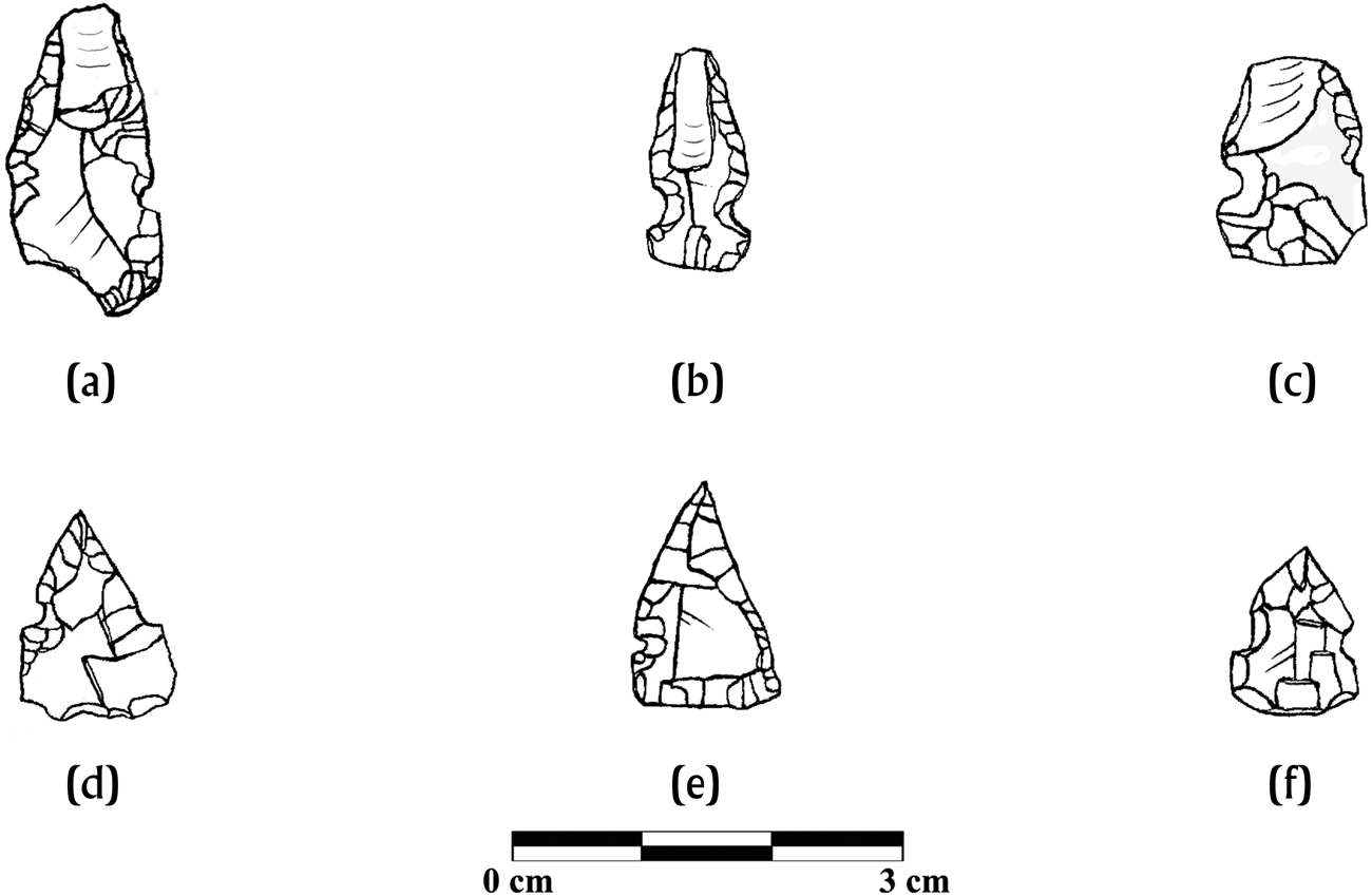
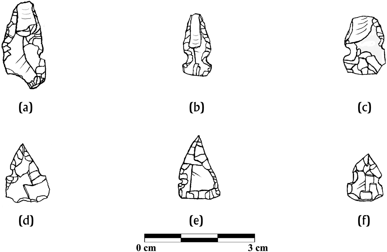
This study examines artifacts often regarded as being mundane or quotidian: chipped-stone tools in the form of small arrow points. Their typical small size (1–3.5 cm), light weight (0.25–1 g), and unique morphology suggest they were indeed projectiles, and distinctive use damage in the form of lateral impact is frequently noted on specimens (Figure 3; Meissner Reference Meissner2014:370). Numerous publications have discussed methods for distinguishing darts from arrow points (Corliss Reference Corliss1980; Shott Reference Shott1997), and the points in this study are far below the reported range for dart sizes. It has been suggested larger dart points used with the atlatl were less common during the Late Postclassic, and may have declined significantly during the Early Postclassic period (Shafer and Hester Reference Shafer and Hester1983:538). A description of a Yucatecan atlatl is found in Bishop Diego de Landa's accounts; however, Spanish documents rarely mention atlatls as a major weapon of resistance in the Maya region (Tozzer Reference Tozzer1941:26, 32). Bow-and-arrow weaponry appears to have been the Early Colonial-era weapon of choice for defense, raids, and hunting (Tozzer Reference Tozzer1941:121).
Types of impact damage and repair found small points in the Peten Lakes region. (a–c) Directional impact damage. (a) Nixtun-Ch'ich’ #42711. (b) Tayasal #85063. (c) Quexil #1578). (d–e) Repaired specimens with irregular margins. (d) Zacpeten #7386. (e) Quexil #1603. (f) Stunted tip length due to repair. Tayasal, #83024. Drawings by the author.
Archaeologically, small points are the most common formal tools encountered throughout the lowlands between a.d. 1350–1525 (Meissner Reference Meissner2014), although some examples are occasionally found during the Late Classic period in the Petexbatun region and the Copan pocket (Aoyama Reference Aoyama2005, Reference Aoyama2008; Meissner Reference Meissner2018b) and in Terminal Classic deposits at Caracol (Chase and Chase Reference Chase and Chase2015:21). Ethnohistorically, only vague descriptions exist about the kinds of bows used by the Maya. A partially preserved wooden bow likely dating to the Late Classic period was found at Uaxactun, measuring 1.02 m long and was manufactured from heavy guayacán wood (Smith Reference Smith1937:35, Figure 2.10). An estimation of original length from photos suggests it was 1.37 m long with a unique square arrow-rest cut in the interior near the knocking point. The curvature of the specimen is unlike ethnographic Lacandon examples that are either straight (sometimes called “ideal”) or bowed slightly away from the shooter to maximize force (Nations Reference Nations, Gaxiola and Clark1989:452).
This study focuses on a collection of 1,661 projectile points originating from 14 Late Postclassic/Early Colonial period sites stretching across the subregion. Of this sample, 1,378 were examined more closely by the author. Analysis focused on two domains: (1) characterizing similarities and differences in raw material selection of stone tool producers and users; and (2) characterizing technological differentiation throughout the subregion as it relates to information sharing among producers and/or migration. Interpretations of point use through impact damage, repair, and fragmentation are relevant; however, due to length constraints, a discussion of this topic is too lengthy to provide here (Meissner Reference Meissner2014:365–539). Estimating the degree of inter-Maya conflict from point assemblages is difficult because most projectiles were likely used for hunting. For example, previous immunological testing of 108 projectiles from Peten revealed that of the 37 immunological positives to fauna, only two tested positive for human protein—accounting for just 5.4 percent of the sample (Meissner and Rice Reference Meissner and Rice2015). Additionally, obsidian blades (prior to being reduced into points) played an essential role in bloodletting and autosacrifice, which could leave similar residue (Stemp Reference Stemp2016; Stemp et al. Reference Stemp, Braswell, Helmke and Awe2019). Thus, the assumption that merely the presence of small arrow points denotes warfare or hostility among groups requires scrutiny.
To understand the first domain, macroscopic and instrumental data were used to identify various forms of siliceous stone, including broad separations between chert, chalcedony, and obsidian used for points. The distinctions between obsidian and microcrystalline silicates are obvious, but distinguishing between chert and chalcedony can be challenging (Leudtke Reference Leudtke1992). For the sake of this study, chalcedony was distinguished from chert by visual properties which included the relative translucency and the “soapy” or frosted appearance of chalcedony. For this study, cherts were further subclassified as originating from the Northern Belize Chert-Bearing Zone (NBCZ)—an area of distinctive fine cherts occasionally referred to as “Colha” chert in the literature (Shafer and Hester Reference Shafer and Hester1983).
Chert and chalcedony resources varied across the central lowlands, and it is difficult to assign most microcrystalline silicates to an exact source. Workable microcrystalline silicates are in Early Cretaceous deposits in relatively heterogenous pockets, except for the “Chert-Free Zone” of younger strata in northern and eastern Yucatan (Hearth and Fedick Reference Hearth, Fedick, Hruby, Braswell and Mazariegos2011:72). Unfortunately, widespread and extensive systematic surveys of microcrystalline silicates have not taken place in the subregion. Most published descriptions of chert formation in the Maya lowlands show that chert was formed in nodules, in contrast to bedded cherts in the form of shales (Aldenderfer Reference Aldenderfer, Hester and Shafer1991; Barrett Reference Barrett, Hruby, Braswell and Mazariegos2011; Moholy-Nagy Reference Moholy-Nagy1997; Oland Reference Oland1999; Potter Reference Potter, Sabloff and Henderson1993). In the Peten Lakes region, nodules are frequently encountered in small to medium sizes in limestone soils (Aldenderfer Reference Aldenderfer, Hester and Shafer1991) and large nodules have been noted in construction fill in western Peten Lakes sites (Rice et al. Reference Rice, Carlo, McNeil, Meissner, Pugh, South, Toraya, Rice, Polo and Rice2007). Chert sources have been identified close to Lake Peten Itza in the hills near the modern city of San José. Chalcedonies are also found in the Peten Lakes region and may be local (Aldenderfer Reference Aldenderfer, Hester and Shafer1991:123).
In Belize, abundant cherts have been reported in the Mopan Valley, and both high-quality and low-quality materials often appear in the same source area or quarry (Horowitz Reference Horowitz2018). Microcrystalline silicates have been noted around Pook's Hill, with lower quantities of chalcedony (Stemp et al. Reference Stemp, Helmke and Awe2010). Fine chalcedony is present near the site of Chau Hiix, and local chalcedonies may have been available around the sites of Cerros and Santa Rita Corozal (Chiarulli Reference Chiarulli2012). Nodules of chalcedony are found east of the New River in northern Belize where a large band of chalcedony-rich deposits that grades between chalcedony and fine chert has been identified (Shafer and Hester Reference Shafer and Hester1983:Figure 1). Around the Freshwater Creek drainage, chalcedonies and chalcedony-quartz blends were common (Oland Reference Oland1999).
Obsidian points were subclassified by volcanic source and reported here from a previous study that used both instrumental portable x-ray fluorescence and visual analysis (Braswell et al. Reference Braswell, Clark, Aoyama, McKillop and Glascock2000; Meissner Reference Meissner2017). The resulting data were compared graphically using social network analysis (SNA) to better understand raw material preferences throughout the subregion. Such methods were adapted from various SNA publications in the Maya region (Golitko and Feinman Reference Golitko and Feinman2015; Golitko et al. Reference Golitko, Meierhoff, Feinman and Williams2012), and used Brainerd-Robinson similarity coefficients as a measure of difference among assemblages (Brainerd Reference Brainerd1951; Peeples and Roberts Reference Peeples and Roberts2013). The resulting data reveal the economic geography of the subregion to highlight salient differences in procurement.
To address the second domain, a macroscopic technological analysis was performed to examine the choices flintknappers made during the creation of small points. The techniques of point manufacture were examined, including inferred core types, blank selection, blank orientation, notching technique, dorsal ridge removal, and invasiveness of flaking (Meissner Reference Meissner2014, Reference Meissner, Rice and Rice2018a). The morphology of points was also noted using measurements of the length, width, blade length, and haft element length of each specimen (Andrefsky Reference Andrefsky1986). Taxonomic classification of haft element morphology and alignment was also included in the analysis following the system outlined in Meissner (Reference Meissner2014:272).
RESULTS
Despite the extant use of the bow-and-arrow in Peten and Belize, the technological systems of arrow points appear to be largely localized. Such information does not suggest intensified circulation of finished goods or strong horizontal information sharing among flintknappers across the subregion. A summary of the results for each research domain are provided below.
Raw Materials: Chert, Chalcedony, and Obsidian
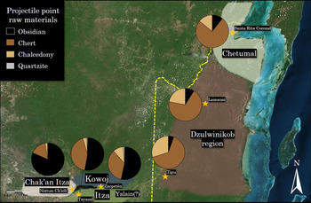
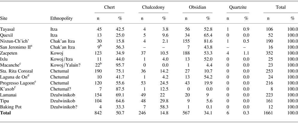
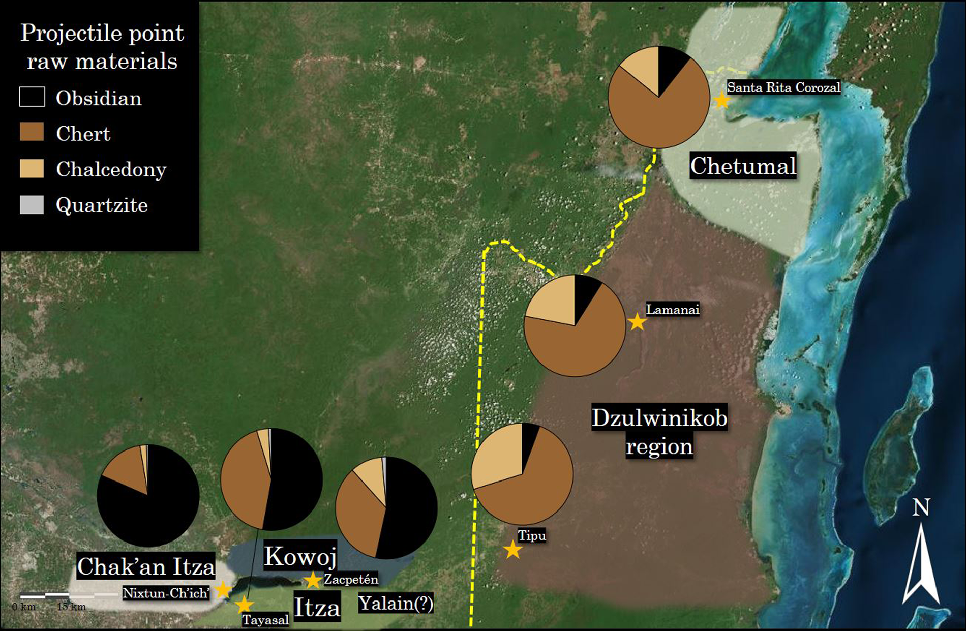
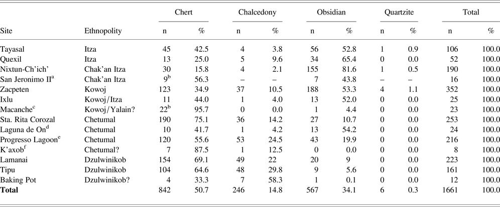
From a technological systems perspective, it is useful to characterize various procurement strategies for lithic manufacture. The type of raw material was identified for all points in the current study and from previously published research. The results of a basic raw material sort are presented in Table 1, and results from major sites in the study are shown in Figure 4.
Major centers with proportions of raw materials used for small point manufacture in the Peten-Belize subregion during the Late Postclassic/Early Colonial period. Modified and redrawn from Google Earth satellite imagery by the author.
Raw materials selection for small Late Postclassic–Early Colonial projectile points in the Peten-Belize subregion.
a Rockmore (Reference Rockmore2006:379).
b Unclear in publication if “chert” refers to all microcrystalline silicates including chalcedony.
c Rice (Reference Rice1987:213).
d Masson (Reference Masson2000:124–125).
e Oland (Reference Oland2009:204,Table 4.9).
f McAnany (Reference McAnany, Peterson and McAnany2004:284, Table 11.2).
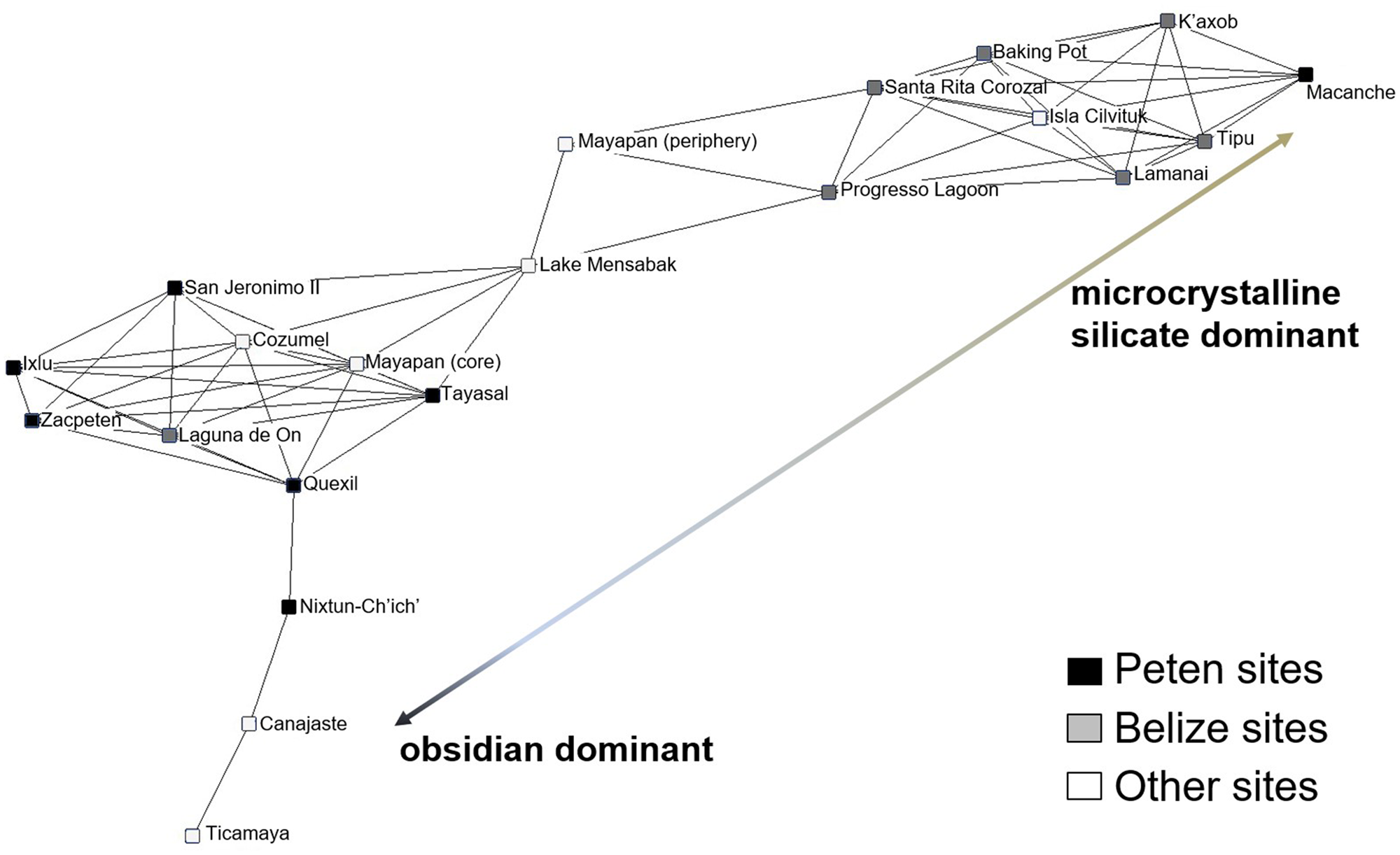
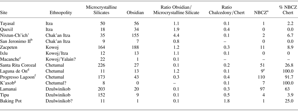
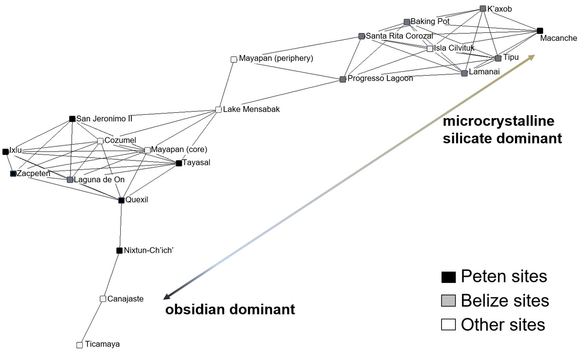
First, it is clear that flintknappers belonging to ethnopolities in the Peten Lakes region exploited lower quantities of chert and chalcedony when compared with those in Belize (Table 2). Figure 5 is the result of a graphical representation using these data using social network analysis (SNA) and Brainerd-Robinson similarity coefficients. The resulting visualization reveals a range of variability among crafting communities who utilized more chert and chalcedony and those that relied mainly on obsidian. All of the Peten lakes groups fell into a similarity subnetwork except for Chak'an Itzas at Nixtun-Ch'ich’. The site assemblage is unusual for its nearly total reliance on obsidian for points, despite chert being readily available in the surrounding area and appearing as debitage (likely for other tools) at the site.
Social network analysis visualization of obsidian to microcrystalline silicate point ratio among Late Postclassic/Early Colonial sites in the Maya Lowlands (spring-embedded, mini-max layout, 167.61 Brainerd-Robinson threshold). Drawing by the author.
Raw material ratios of microcrystalline silicate and obsidian small projectile points in the Peten-Belize subregion. NBCZ, Northern Belize chert-bearing zone.
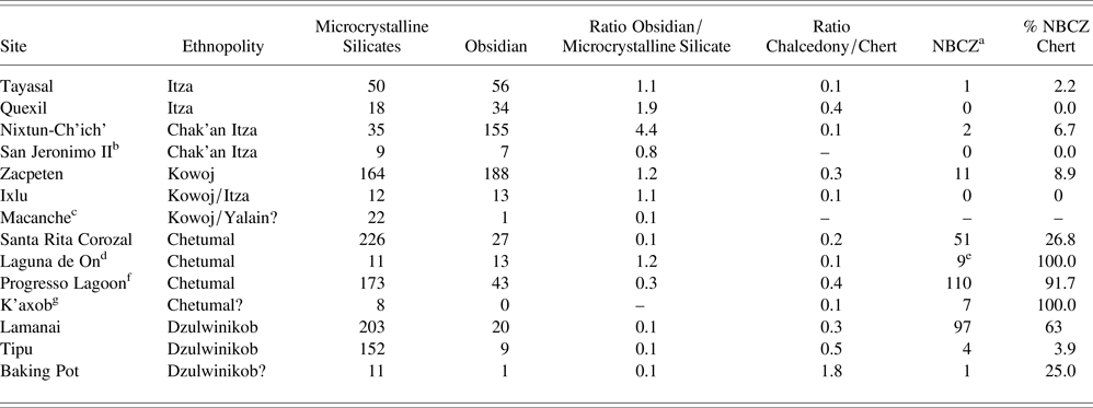
a Visually identifiable material thought to originate from the NBCZ.
b Rockmore (Reference Rockmore2006:379).
c Rice (Reference Rice1987:213).
d Masson (Reference Masson2000:124–125).
e Two points unidentified due to thermal damage.
f Oland (Reference Oland2009:204, Table 4.9).
f McAnany (Reference McAnany, Peterson and McAnany2004:284, Table 11.2).
Among sites in Belize, the ratios of microcrystalline silicate points to obsidian points are unbalanced, suggesting that producers and users in Dzulwinikob and Chetumal preferred local cherts and chalcedonies to imported obsidian. Although Peten sites are closer to the volcanic regions in the highlands (as the crow flies), obsidian is recovered regularly in Late Postclassic contexts in Belize (Masson Reference Masson2000; Seidita Reference Seidita2015; Simmons Reference Simmons2002). Research suggests it is likely that oceanic trade from port areas like Nito and the Belize Cayes connected to rivers to move material inland (McKillop Reference McKillop2010). The vast majority of obsidian artifacts in Belize are related to prismatic blade manufacture and not point production. Studies suggest that obsidian is typically more brittle and susceptible to fracture on impact than cherts (Ellis Reference Ellis and Knecht1997:52; Nelson Reference Nelson and Knecht1997:378). Such information is pertinent to understanding raw material preferences flintknappers had for arrow point manufacture and is discussed in greater detail below.
Compared to polities in the Peten Lakes region, the ratio of chalcedony to chert was higher in Dzulwinikob territory, meaning chalcedonies were exploited more frequently. Whether this is simply a reflection of local geology or preference for the material itself is unknown. Fragmentation studies suggest that chalcedony may have been more durable than chert for use as arrow tips but is generally considered less workable due to its texture (Meissner Reference Meissner2014).
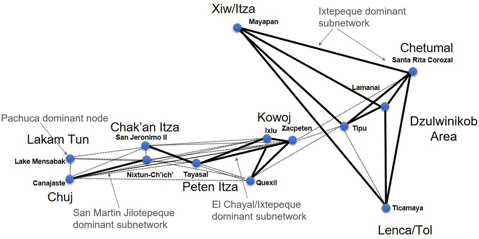
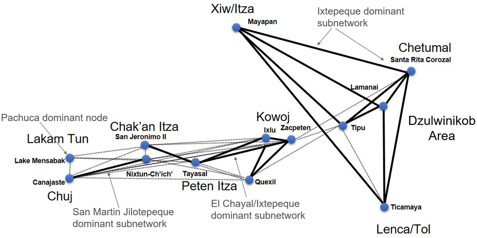
Volcanic origins of obsidian used for small projectile points also varied significantly across the subregion. SNA from a previously published study (Meissner Reference Meissner2017:148–149) revealed a strong subnetwork of obsidian exchange among centers in Belize involving Ixtepeque obsidian (Figure 6). In contrast, the Late Postclassic Peten Lakes region had more diversified patterns of procurement that included El Chayal and San Martin Jilotepeque in addition to Ixtepeque. As argued elsewhere, factionalism between the Chak'an Itza and Itza can be detected through pronounced signatures in obsidian procurement, with the Chak'an Itza utilizing mostly obsidian from San Martin Jilotepeque for point and blade manufacture while their Itza neighbors (only 2.6 km across the lake) relied on diversified Highland sources (Meissner Reference Meissner2017). Lakam Tun populations in Chiapas likely relied on a different network that included both imported Pachuca obsidian and San Martin Jilotepeque. In general, marked differences in obsidian procurement between Peten and Belize are likely political in nature and reflect varying degrees of participation with the circum-Caribbean exchange (McKillop Reference McKillop1996).
Weighted social network visualization of highland obsidian procurement for Late Postclassic/Early Colonial period projectile points. Modified from Meissner (Reference Meissner2017:Figure 9). Strong ties denoted by thick lines, weak ties denoted by dotted lines (Brainerd-Robinson ≥ 147.5 for a strong tie and 147.5 > BR ≥ 107.5 for a weak tie) based on BR similarity coefficients; low link weights excluded.
Raw Materials: NBCZ
Pertinent to this study are the distribution and use of fine quality cherts for points that originate from the NBCZ. The NBCZ is sometimes characterized as a vital resource-extraction zone and affluent production area in some economic models of Postclassic Mesoamerica (Smith and Berdan Reference Smith, Berdan, Smith and Berdan2003:28–29). This area contains some of the finest quality cherts in the Maya lowlands, characterized by distinctive honey-brown or chocolate colors (Shafer and Hester Reference Shafer and Hester1983). Unlike earlier periods, intensive production of lithic tools at the site of Colha began to decline after the Early Postclassic period (Shafer and Hester Reference Shafer and Hester1983:531–532). Thus, Colha was never a major economic player during the Late Postclassic, and access to local high-quality microcrystalline resources may have been less restricted.
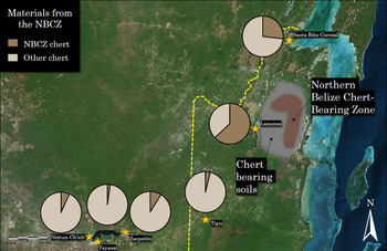
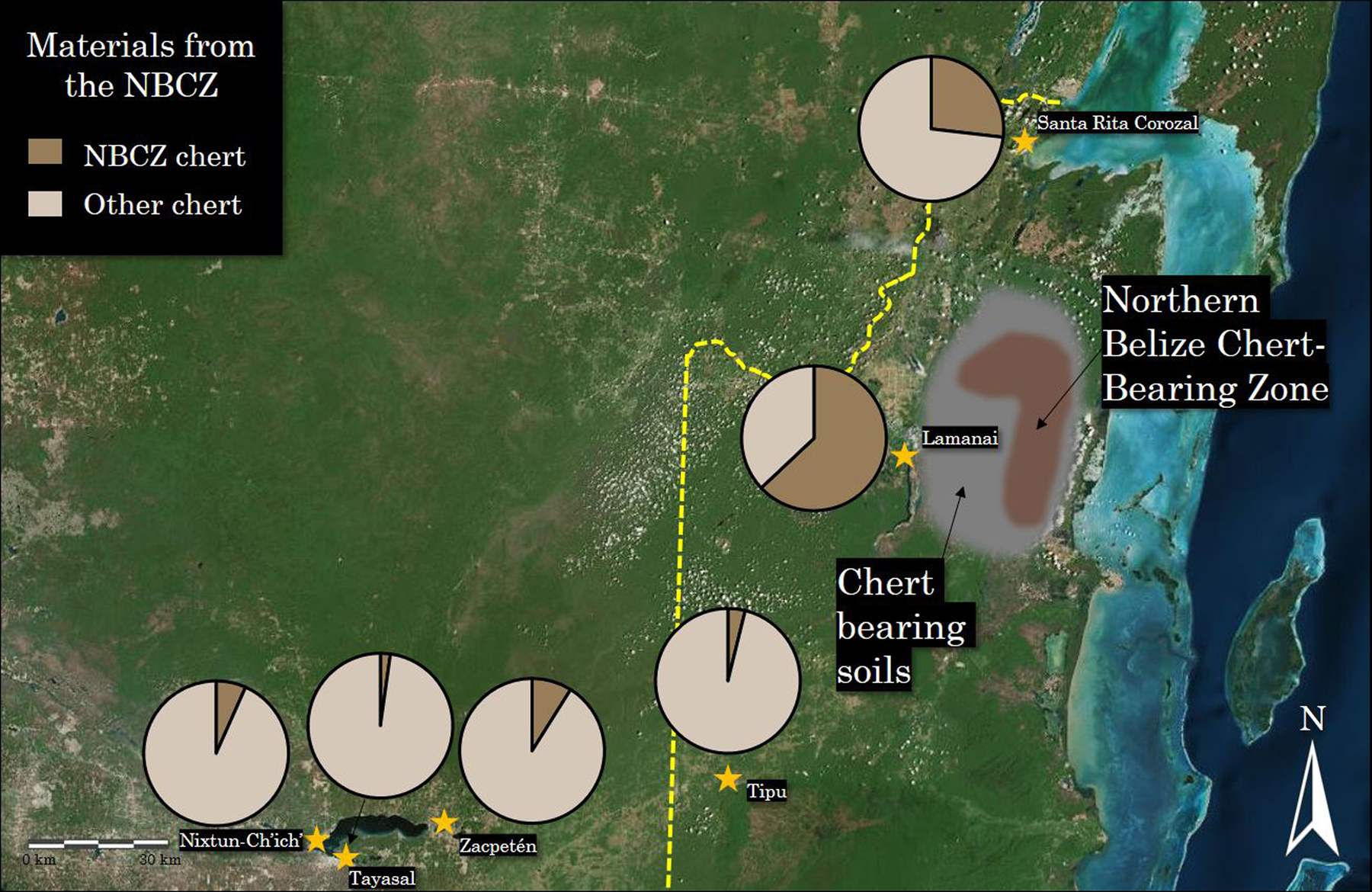
Late Postclassic/Early Colonial period points manufactured from NBCZ cherts were not found in great quantities outside of the immediate area of northern Belize (Figure 7). Sites closest to the NBCZ had the highest frequencies of NBCZ chert and belonged to the northern Dzulwinikob and Chetumal polities. Additionally, each of these political groupings showed significant intrapolity variation in terms of NBCZ use. For example, smaller sites of Laguna de On, Progresso Lagoon, and K'axob had much higher percentages of NBCZ cherts used for projectiles, which differed from the larger regional capital of Santa Rita Corozal where 26.8 percent of points were made from NBCZ materials. The site of Lamanai stands out from other Dzulwinikob sites in its intensive use of fine NBCZ cherts. Of the chert projectile points found at the site, 63 percent of them could be readily identified as originating from the NBCZ. At Tipu, cherts originating from the NBCZ were encountered less frequently, suggesting limited exchange of the resource to western Belize. Of all the projectile points recovered at Tipu, only four were identified as originating from northern Belize, representing just 3.9 percent of the chert points. Negligible amounts of NBCZ points appear to have been used by the Itza (2.2 percent), with elevated levels among Kowoj points (9 percent), perhaps indicative of limited exchange. Thus, these data suggest that distance to the NBCZ is one of the most prominent predictors of the use of the material and that the regionally dominant Chetumal polity did not necessarily extract large quantities of high-quality cherts from surrounding ethnopolities.
Proportions of raw materials originating from the Northern Belize Chert-Bearing Zone used for Late Postclassic/Early Colonial period point manufacture. Modified and redrawn from Google Earth satellite imagery by the author.
Production Attributes and Form: Peten Lakes Region
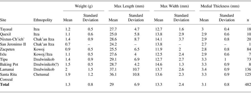
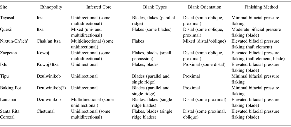
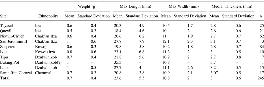
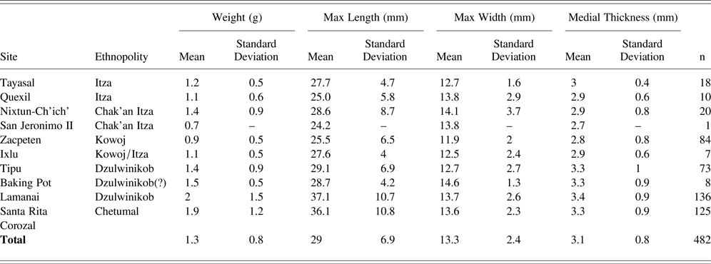
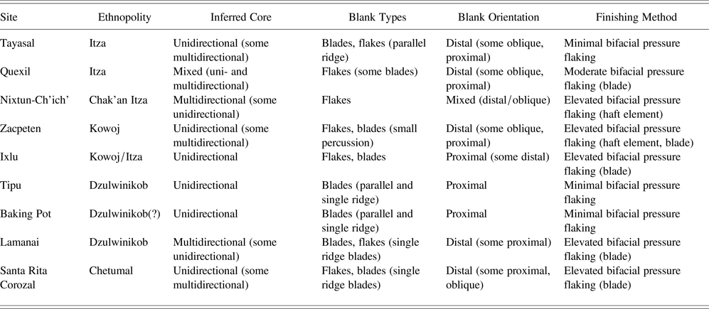
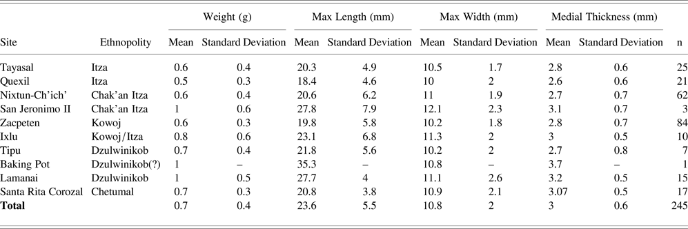
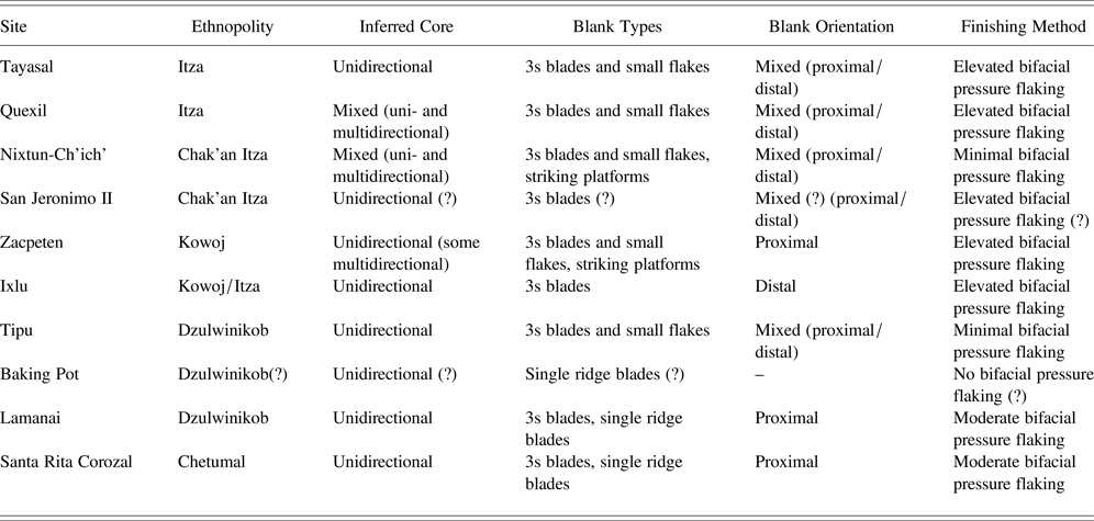
In addition to raw materials selection, there were also differences in the technological and morphological aspects of small points across the subregion (Tables 3–6). Although each attribute cannot be discussed in detail due to length constraints (Meissner Reference Meissner2014:237–354), data suggest subtle but significant differences in manufacturing among ethnopolities when controlling for material. Data originating from the major centers are highlighted below with a discussion of microcrystalline silicate (chert and chalcedony) points followed by obsidian.
Summary of quantitative measurements of complete Late Postclassic/Early Colonial microcrystalline silicate arrow points.
Summary of the most frequently encountered production techniques for Late Postclassic/Early Colonial microcrystalline silicate projectile points.
Summary of quantitative measurements of complete Late Postclassic/Early Colonial obsidian arrow points, including mean and standard deviation (SD).
Summary of the most frequently encountered production techniques for Late Postclassic/Early Colonial obsidian projectile points.
Microcrystalline Silicates
A summary of point metrics from complete microcrystalline silicate points is found in Table 3. A comparison with obsidian points suggests the siliceous points tend to be slightly larger in mean size, and importantly nearly twice the weight. Dimensions varied at an inter-site level, where Peten Lakes points tended to be smaller with lighter weights and shorter dimensions (~2.5–2.8 cm in length). Belize point samples from Lamanai and Santa Rita Corozal were characterized by heavier weights, longer complete lengths (~3.6–3.7 cm) with more diverse standard deviations close to 1 cm (Table 3).
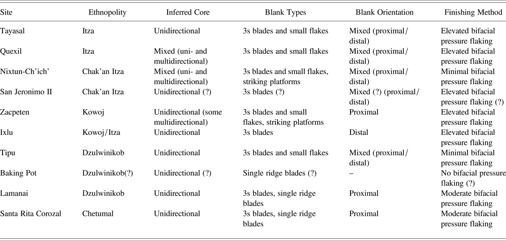
Technological characteristics also differed among the siliceous specimens (Table 4). When examining the inferred core types used for making chert and chalcedony point blanks, a mixture of multidirectional and unidirectional blade core methods appear to have been used by the Itza and Kowoj, with Kowoj flintknappers utilizing unidirectional cores more frequently. Chak'an Itza cores tended to be multidirectional with few unidirectional blanks found. Thermal alteration of raw materials was identified in moderate frequencies throughout the entire Peten lakes region. Itza projectiles had low levels of bifacial pressure flaking and were largely minimally retouched blades and flakes. Tayasal points had significantly lower chert production input than the Zacpeten assemblage. Low production input noted at Tayasal may suggest that points were produced with greater expediency and minimal marginal flaking (Meissner Reference Meissner, Rice and Rice2018a).
Haft elements (i.e., bases) tended to be much shorter in the Peten Lakes region, and negligible morphometric variability was encountered among the Itza, Chak'an Itza, and Kowoj. Of the chert points in the Tayasal sample, the majority (59.45 percent) tended to be curved with an emphasis on recessed or slightly recessed base orientation. The tendency to create haft elements narrower than the blade (recessed) occurs in 51.6 percent of the siliceous stone points from Tayasal, which appeared to be a localized phenomenon. Additionally, an examination of notching preferences revealed that Tayasal had almost exclusively side-notched points. Curved haft elements were found in the highest frequency at Nixtun-Ch'ich’ (43.5 percent), and alignments were found to be projecting (52.1 percent), with fewer flush and recessed examples found in the assemblage. This suggests that producers at Nixtun-Ch'ich’ had different ideals of design realization when compared to Tayasal, suggesting some differentiation between the Chak'an Itza and the Itza. Most haft elements manufactured by the Kowoj tended to be curved with very few recessed examples of alignment.
Obsidian
As mentioned previously, obsidian points tended to be much lighter than chert and chalcedony variants (Table 5). This is likely due to the thin nature of the specimens that were largely manufactured using third series (3s) prismatic blades (Clark and Bryant Reference Clark and Bryant1997); however, the use of small flake blanks was also common in Peten (Table 6). Looking closely at the individual sites and associated ethnopolities, there was not a great deal of metric variability among sites (Table 5). Data indicate that Lamanai in the Dzulwinikob region had some of the largest obsidian projectiles, with weights nearly double the means of Quexil (Itza) and Zacpeten (Kowoj). In general, ethnopolities located in the Peten Lakes region tended to have some of the lightest obsidian points in the Maya lowlands.
In Chak'an Itza territory, some multidirectional obsidian cores were used. Blank orientation was random throughout the Peten Lakes sites, and medial segments of obsidian prismatic blades were utilized more frequently at Tayasal. By weight, ethnopolities located in the Peten Lakes region tended to have some of the lightest obsidian points when compared to sites in Belize. Considerable variability in production input was found. Points from Chak'an Itza territory were found to have significantly lower flaking input when compared to those from Kowoj territory. In general, there were more unnotched specimens at Nixtun-Ch'ich’ when compared to Tayasal. In the subsample, 23 haft elements were unnotched, consisting of 22.7 percent of the data. Of the notched projectiles, haft element types were similar to those from Itza territory, with 24.4 percent being a curved design. Although there was not much variability among Kowoj obsidian points, there was a slight tendency for unnotched haft elements to be used—occasionally with proximal indentation.
Production Attributes and Form: Belize
Microcrystalline Silicates
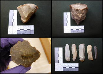
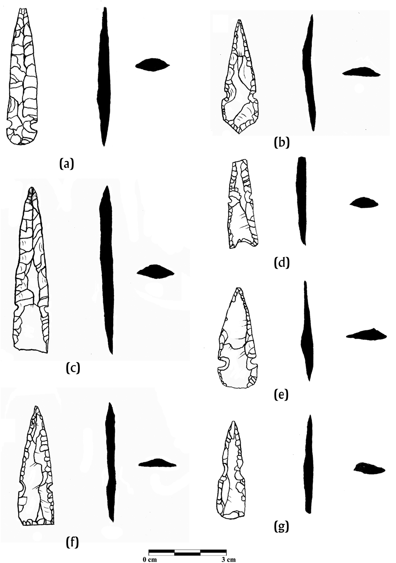
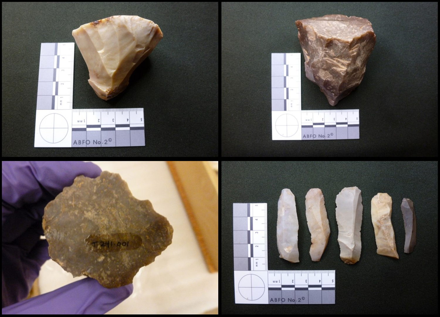
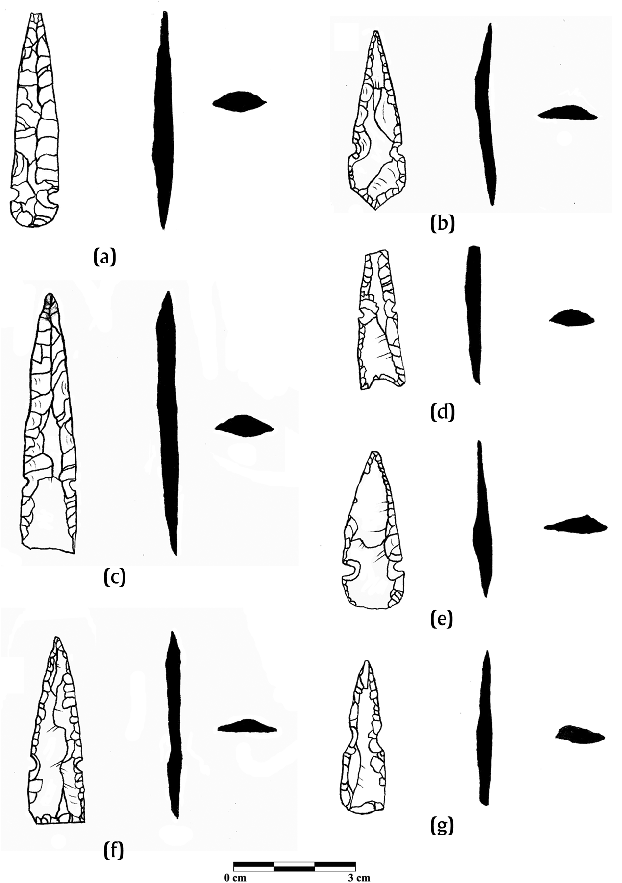
From the perspective of lithic production, sites in Belize have highly distinctive production attributes of small projectile weaponry (Figures 8 and 9, Table 3). One of the most notable methods of point manufacture was encountered at Tipu, where unidirectional blade-core technology (likely using indirect percussion) was used almost exclusively to produce blanks for chert points (89.1 percent; Figure 8). Such techniques are similar to historic and contemporary Lacandon populations in Chiapas where a core is held in one hand along with a punch (usually an antler tine). Using the opposite hand, the punch is struck with a flat stone to remove a short blade or blade-like flake. This technique creates blades in a unidirectional manner, and the blades are later minimally reshaped into small projectiles (Clark Reference Clark, Hester and Shafer1991; Palka Reference Palka2005). Although the sample size is too small to make broad inferences, this technique was also found at nearby Baking Pot.
Examples of core-blade chert technology used for point blanks from Tipu in the Dzulwinikob region. Photograph courtesy of the Royal Ontario Museum.
Late Postclassic microcrystalline Silicate Points from the Chetumal ethnopolity, Santa Rita Corozal, Belize. (a) Chalcedony point P38b/10-4 (#20695). (b) NBCZ chert P10b/8-7 (#20805). (c) Thermally altered chert P34a/16-1. (d) Chert point with indented proximal edge P33a/15-1 (#20766). (e) Chalcedony point P6c/40-4 (#20837). (f) NBCZ chert P8c/34-3 (#20806). (g) Patinated chert point P8c/45-11 (#20809). Drawings by the author.
At Lamanai, multidirectional percussion flake blanks were used in higher frequencies. Interestingly, points from Lamanai shared many technological similarities with Santa Rita Corozal, including a strong tendency for intensive production investment shown by pronounced bifacial pressure flaking. Quantitative measurements from the sites revealed dissimilarities in point weight and dimensions. Lamanai and Santa Rita Corozal had some of the largest chert arrow tips in the entire Maya lowlands (see Table 3). Such data could suggest that the flight range of arrows was not of utmost concern for residents as heavier tips typically result in shorter shots (Klopsteg Reference Klopsteg1939).
In terms of haft element morphology, there was some diversity among the Belize centers. Haft elements were found to be more elongated at Santa Rita Corozal and Lamanai than other centers. Although many polities had curved bases in the assemblage, one major difference was found at Santa Rita Corozal where contracting stem haft elements with excurvate proximal edges were found in high quantities. This pattern contrasts greatly with ethnopolities found in Peten and also with Tipu where the majority of the microcrystalline silicate specimens had curved bases, consisting of 58.9 percent of the sample. Tipu points had one of the highest frequencies of base recession when compared to the blade with 48.7 percent of notched specimens (n = 54).
Obsidian
Although obsidian specimens were rare in Belize, 3s prismatic blades were also the most common type of blank, with single ridge (versus trapezoidal) specimens being more common at Lamanai and Santa Rita Corozal. Blank orientations at these sites tended to have proximal orientations in contrast to those found at Tipu and in the Peten Lakes region. In Chetumal, 81.8 percent of the obsidian points were found to have proximal orientations compared to 18.2 percent distal. This discrepancy is not likely due to random chance and may relate to techniques in production where 3s blades were intentionally shaped to a point and then snapped for further finishing.
Throughout Belize, the most common haft element forms were either curved or contracting stem with a flat proximal edge. Data suggest that Lamanai had some of the largest obsidian projectiles, with weights nearly double the mean of some Peten Lakes centers. At Tipu, obsidian base alignments tended to be either flush or projecting, and one indented base was identified. Santa Rita Corozal obsidian points were unique in that no specimens with recessed bases were found. The most frequently encountered alignment was a projecting style (55.6 percent) or a flush style (44.4 percent). Of the notched obsidian examples, only one (5.26 percent) was found to be indented with the remainder having flat (52.6 percent) or excurvate/pointed (42.1 percent) proximal edges. All unnotched obsidian points were found to have flat proximal edges.
DISCUSSION
Utilizing a technological systems approach to lithic data reveals the intricacies of Late Postclassic and Early Colonial period interaction and social boundaries. The current research strongly suggests that localized networks of chert and chalcedony procurement—often at the level of individual sites—were in place during this time. The boundaries of these groups (both cultural and geographical) were certainly not absolute, and there is a substantial critique in anthropological literature of approaching culture groups as overly “monolithic” and easily demarcated (Wolf Reference Wolf1982:3).
Broad similarities in raw material preference—mainly the proportional relationship between microcrystalline silicates and obsidian—showed a strong pattern when comparing Belize to Peten Lakes Mayas. Such differences are likely cultural in nature. As mentioned previously, obsidian tends to be more susceptible to fracturing and less reliable for re-use in the form of projectiles (Ellis Reference Ellis and Knecht1997; Nelson Reference Nelson and Knecht1997). Such breakage, however, might have a functional advantage when used as arrow tips. According to the modern Lacandon, a chert point is thought to “usually kill” where an obsidian point “always kills” due to the mortal wounds inflicted by fragmentation (Nations Reference Nations, Gaxiola and Clark1989:454). Thus, the durability of microcrystalline silicate tips might have made them more favorable for arrow reuse and resharpening, but the brittle nature of obsidian may have been perceived as more lethal (and favored) among particular Maya groups. A strong west-east distinction was also reflected in differential participation in highland obsidian exchange networks, where it is clear that ethnopolitical groups accessed obsidian through different exchange networks. Mayas in the Peten likely accessed overland routes to the south, whereas polities in Belize participated more with coastal supply from the east. Interestingly, few points made from NBCZ chert are found in great distances from the source area, and large regional polities like Chetumal did not appear to capitalize on resource-rich extraction areas of northern Belize for long-distance exchange during the Late Postclassic and Early Colonial periods.
If markets or market-like mechanisms of exchange were in place in the Peten-Belize subregion, this study provides support for loosely overlapping market spheres reflecting a weak, albeit present boundary between Belize and Peten populations. Some intra-Peten and intra-Belize restrictions are apparent that were likely related to lineage or ethnopolitical organizations, possibly through administered competitive markets (LeCount Reference LeCount, Fargher and Heredia-Espinoza2016). For example, social processes like factionalism among the Chak'an Itza may have restricted exchange spheres and technological sharing with nearby Itza neighbors.
Notable differences among the metrics and technological styles of points were noted in the Peten-Belize subregion. Quantitative measurements from all sites revealed dissimilarities in point weight and dimensions. Such differences can be attributed to variation in the design process and are not necessarily random. Lamanai and Santa Rita Corozal had some of the largest arrow tips in the Maya lowlands. Such differences likely relate to the center of gravity of an arrow (Knecht Reference Knecht and Knecht1997:14), and may represent differences in bow technology among groups. Larger arrows may have required larger bows for firing accuracy, whereas smaller arrow tips could be paired with smaller, more portable bows.
Interestingly, the closest site to the Peten centers, Tipu, had a distinctive technological tradition that did not clearly resemble any of the polities in the study and instead resembles historic and contemporary Lacandon knapping traditions. Such a distinction could be due to the intersitial “frontier” location of the site—between two regionally dominant Itza and Chetumal polities (Halperin et al. Reference Halperin, Friewald and Iannone2020). This location in the fringes of overlapping power structures may have spurred a unique form of ethnogenesis among Tipuans and Dzulwinikob residents in this area. Graham (Reference Graham2011:55) suggests viewing Tipu as a corporate kaj in which individuals may have been able to “claim membership in more than one patronym group.” Such formations of new identities may have developed highly localized economic structures as inhabitants differentiated themselves from surrounding populations.
The results of this study reflect some social mechanisms that defeat boundaries and boundary maintenance. Archaeologists working in the subregion must not underestimate the role of migration, and especially in the time of the Contact/Colonial period, the processes of displacement and diaspora from home communities. Such activity would result in horizontal information sharing if refugees were accepted into new communities. Exogamous marriage strategies may carry technological knowledge across ethnopolitical boundaries as well as actual material culture.
In contrast, strong endogamy within real or imagined lineage-affiliated groups (or social houses) might produce more homogeneity in lithic technology. Factors concerning the time depth of settlement and deep-seated notions of ancestral lands factor into strong vertical transmission and differentiation of point traditions over time. For example, it is possible that the Chak'an Itza, Kowoj, and Yalain of Peten may have initially been part of a larger Itza polity before later fragmentation and reformulation. The lineage name Kan Ek’ (associated with the Itzas) documented in the Early Colonial period likely has origins among Mayas during the Late Classic and Terminal Classic (Boot Reference Boot1995, Reference Boot1997; Rice and Rice Reference Rice and Rice2018b). Interestingly, this ancestral name appears mainly in Peten and Yucatan, but rarely in western and northern Belize. Additionally, a study of Classic-period emblem glyphs as political ties reveals much of the political interactions occurring internally within the southern lowlands but infrequently along a west-east axis into Belize (Munson and Macri Reference Munson and Macri2009). From the perspective of ceramic technology, Callaghan and Kovacevich (Reference Callaghan and Kovacevich2019) suggest that ceramic styles begin to differentiate across what is now the Peten-Belize border as early as the Terminal Classic. Such social differentiation could explain some of the broader differentiation that is seen in lithic data during the Postclassic.
CONCLUSIONS
This study has examined the relationship between political geography, procurement, and production across the geographically porous northern Peten-Belize subregion. Marked differences in the technological systems of small projectile points are present among the ethnopolities in this subregion and shed light on a poorly understood time. If point technology is used as a proxy for interaction, hostility, and migration, it is clear that various Late Postclassic and Early Colonial period ethnopolities in Peten were not sharing a great deal of materials or technological knowledge with groups in Belize. This demarcation, however, was not absolute, and some aspects of exchange and information-sharing took place on a minor level possibly through limited contact or in-migration. Pronounced variability in the origin, quality, and type of raw materials used for point manufacture may relate to regional hostilities during a time of political instability. A deemphasis on horizontal information sharing might attest to a general restriction of interaction among ethnopolities, possibly even beginning during the Terminal Classic period. Thus, this study nevertheless reveals the necessity of fine-grained analysis of both materials and production strategies of formal stone tools in the study of Maya economies.
RESUMEN
Este estudio examina la intersección de las diferencias políticas, culturales y lingüísticas en el estudio sobre las fronteras desde una perspectiva arqueológica. Los períodos del posclásico tardío y de contacto (1350–1525 d.C.) en las tierras bajas mayas son conocidos por la inestabilidad política y la formulación de nuevas identidades, especialmente en la subregión de la actual frontera entre Guatemala y Belice. Este estudio aborda las posiciones teóricas sobre las fronteras prehispánicas y durante el contacto desde el enfoque de la tecnología lítica, centrándose en las puntas de proyectil recuperadas en numerosos sitios de la subregión. El análisis de los datos sugiere no solo diferencias en la adquisición y producción de recursos, sino también en la vida útil de las herramientas líticas durante un tiempo de interacción históricamente fluida y con conflictos ocasionales en el área de Belice-Petén. Dicha información se suma a nuestra comprensión sobre las fronteras o límites de los unidades políticas durante el posclásico tardío desde una perspectiva social y económica, la cual a menudo es ignorada.
La investigación actual sugiere de manera convincente que durante el posclásico se establecieron redes localizadas de adquisición de pedernal y calcedonia, a menudo a nivel de sitios individuales. Los límites de estos grupos (tanto culturales como geográficos) no eran ciertamente inmovibles. Las amplias similitudes en la preferencia de la materia prima, principalmente la relación proporcional entre pedernal y obsidiana, mostraron un claro patrón al compararse entre los mayas de Belice con los del Petén. Así también, fue clara la distinción reflejada en la participación diferencial en las redes de intercambio de obsidiana de las tierras altas y bajas, mostrando que los grupos etno-políticos del Petén y Belice accedieron a diferentes redes de intercambio.
Por otro lado, fueron identificadas diferencias notables entre los estilos tecnológicos de las puntas en la subregión de Petén-Belice. Curiosamente, el sitio más cercano a los centros de Petén, Tipu, tenía una tradición tecnológica distintiva que claramente no se parecía a ninguna de las unidades políticas de estudio y, en cambio, se asemeja a las tradiciones históricas y contemporáneas del área Lacandona. Tal distinción podría deberse a la fluctuación “fronteriza” entre dos unidades políticas, Itza y Chetumal, que fueron regionalmente dominantes. La ubicación al margen de la superposición de estas estructuras de poder, pudo haber propiciado una forma de etnogénesis entre los residentes de Tipu y Dzulwinikob en esta área.
Las marcadas diferencias en las tecnologías para la manufactura de pequeñas puntas de proyectil están presentes entre las unidades etno-políticas en esta subregión y arrojan luz sobre un momento poco comprendido. Si la tecnología de las puntas de proyectil se utiliza como una aproximación para el entendimiento de la interacción, la hostilidad y la migración, es claro que diferentes unidades etno-políticas del período posclásico en el Petén no compartían una gran cantidad de materiales o conocimiento tecnológico con los grupos de Belice. Sin embargo, esta demarcación no fue absoluta, y está claro que algunos aspectos de intercambio, tanto de bienes como de información, tuvieron lugar en un nivel menor, posiblemente a través de un breve contacto o de migración. Las diferencias en la procedencia, la calidad y el tipo de materias primas utilizadas para la fabricación, pueden estar relacionadas con la competencia por los recursos naturales durante un momento de inestabilidad política. Además, un énfasis en el intercambio de información horizontal atestigua una restricción general de la interacción entre los grupos, que posiblemente comenzó inclusive desde el período clásico terminal.
ACKNOWLEDGMENTS
I would like to thank the organizers Christina Halperin, Carolyn Freiwald, and Gyles Iannone for arranging a thought-provoking SAA session and editing this special issue. Prudence Rice made this study possible. Financial support was provided by a National Science Foundation dissertation improvement grant to Nathan Meissner and Prudence Rice (#1146372). Data from Peten were gathered from NSF Grants to Prudence Rice and Timothy Pugh (#0917918, #1037927, and #0742295). Previous support for excavations at Nixtun-Ch'ich’ was provided by the Heinz Foundation and the National Endowment for the Humanities. The Santa Rita Corozal data was collected as a result of excavations funded by NSF Grants BNS-8509304 and BNS-8318531 (both to D.Z. Chase and A.F. Chase). I also thank the following individuals for their assistance: Timothy Pugh, Carlos Sanchez, Evelyn Chan, Don Rice, Elizabeth Graham, Julie Hoggarth, Jaime Awe, Arlen Chase, Diane Chase, Katie South, Miriam Salas, Kevin Schwarz, Matthew Rockmore, Matthew Yacubic, Yuko Shiratori, Teresa Palomares, and Marc Marino (PPP4L). Institutional support was provided by the Instituto de Antropología e Historia de Guatemala, and Lica. Rita Casas helped with obtaining permissions for exports from Guatemala. The Royal Ontario Museum (April Hawkins, Justin Jennings) and the Belize Institute of Archaeology (NICH) provided access to the Belize point collections. I would also like to thank the anonymous reviewers of this article who offered insightful suggestions and constructive criticism.