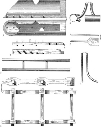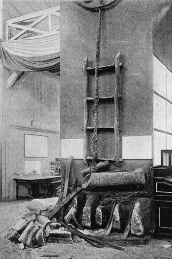


In 1817, workers in a salt mine at a locality called Királyvölgy (King's Valley), near Alsó-Nyéresháza in the Máramaros, the north-easternmost county of the Austro-Hungarian Empire, came across a set of wooden objects, including a ladder, a trough and a mallet, in an old pit that was part of the shaft they were working. Eduard Preisig, an Austrian mining specialist, published the first known account of the finds sixty years later (fig 1).Footnote 1 According to Preisig, the objects were taken from Királyvölgy and kept at the nearby mining centre of Szlatina (now Solotvino), where he himself worked. They were later removed to Budapest and eventually went on display there in the museum of the Hungarian State Geological Institute; we know this because, in the early years of the twentieth century, a photograph of them was included in the published museum catalogue (fig 2).Footnote 2
Drawings from the first publication of the Királyvölgy finds. (1) Trough; (2) trough base; (3–4) ladders; (5) mallet; (6) shovel; (7) ‘Haggen’. Nos 3, 6 and 7 have not survived. Drawing: Preisig Reference Preisig1877

Photograph of the objects from Királyvölgy as displayed in the museum of the Hungarian State Geological Institute in 1909. Photograph: Vezető 1909

When archaeologists began taking a renewed interest in prehistoric salt production in the late twentieth century, the objects were not to be found in the Geological Institute's museum and it was feared that they had been lost or removed – perhaps during the upheaval of the Second World War (see Appendix). Thanks to the detective work of Dr Carol Kacsó, of the Regional Museum of Baia Mare (Romania), however, the objects were traced to the Hungarian Central Mining Museum (Központi Bányászati Múzeum) in Sopron, Hungary.Footnote 3 As a result of that rediscovery, permission was obtained for samples to be taken for dating. This paper presents the results of that work in the form of a set of radiocarbon dates that sets the objects firmly in the Bronze Age; it also provides a context for them, in terms of current knowledge of prehistoric salt production in central and eastern Europe.Footnote 4
Site location and nomenclature
Geologically speaking, the salt of this part of Ukraine lies in the Neogene deposits and specifically the Tereblya formation of the Middle Badenian rocks.Footnote 5 The upper part of this formation is halogenous, with grey and white crystalline salt in packets and lenses of grey clays bedded in salt ‘cheeks’ of varying depths. A detailed description of the local conditions was given by Buschman.Footnote 6
Much has changed in the political landscape of Europe since the discovery of the objects in 1817. Nineteenth-century mining at and near Szlatina was conducted by Austrian engineers but the population was mostly Romanian and Ukrainian, with Hungarian and Jewish minorities. With the defeat of Hungary in World War I and the Treaty of Trianon (Versailles) in 1920, the area in which Királyvölgy lies came under the jurisdiction of the newly created state of Czechoslovakia, as the province of Podkarpatská Rus (‘Subcarpathian Russia’), while south of the Tisza the expanded Romanian state acquired the Máramaros (now Maramureş). At the end of World War II, this easternmost part of Czechoslovakia was annexed by the Soviet Union and became part of the Ukrainian SSR. Finally, with the breakup of the Soviet Union in 1991, it became part of the independent state of Ukraine.Footnote 7
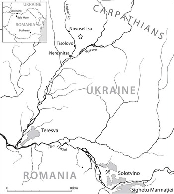
As a result, the name of the place has at least three versions, all of which can be found in the literature: Királyvölgy (Hungarian), Königstal (German) and Valea Regilor (Romanian); all mean ‘King's Valley’.Footnote 8 The presumed findspot is situated some 1.8km uphill from the present-day hamlet of Tisolovo, which lies on the Luzhanka stream, between the villages of Novoselitsa and Neresnitsa, the stream flowing south east to join the River Teresva (fig 3). Arguably, therefore, its official name should be Tisolovo. At present, however, the scientific world refers to the site as Királyvölgy or Valea Regilor, and the former is the usage adopted here.Footnote 9
Location map for Királyvölgy (shown as a star), in Tyachiv district, Zakarpats'ka oblast', Ukraine (formerly Tarac district, Máramaros, Hungary). Drawing: Seán Goddard

The discovery
The earliest certain account of the discoveries is by Preisig, subsequently cited by several recent authors.Footnote 10 The information was repeated by Buschman in his comprehensive work on salt.Footnote 11 The photograph of the objects published in 1909 has also been much reproduced in recent times.Footnote 12
Preisig's account is worth citing in extenso:
In 1817 an old mine-pit, Fig. 10, 9.5m long and 3.8m wide was encountered in the shaft of the newly opened Franz Pit at a depth of 13m. At the narrowing of the southern side a small sump was constructed to collect water, but in the southern drift wall an ancient mine opening was reached, Fig. 9 and 10, which was full of old wood, bast ropes, clay and silt, and, after the ensuing cleaning, could be seen as a pit of irregular dimensions, 13m in diameter and 4.7m high, the floor level of which lay at a depth of 16m from the surface. In the following years, but especially in 1846 and 1847, more shafts were found, the smallest with a cross-section of at least 7m2, and boarded with undressed oak and beech wood 16 to 26cm thick; in addition, in the places where the salt lay closer to the surface, similar pieces occurred, which by virtue of its width and the breadth of 32–34cm, and the 7.5 to 9.5m long undressed wood, indicated a simple open-air mining technique.
In all these constructions, various tools and objects were found, providing a clear explanation of the contemporary extraction method; the most important are illustrated in Fig. 11–29.Footnote 13
The passage goes on to speculate on the age of these remains, pointing out that the wooden objects are completely black and, being impregnated with salt, are well preserved. The crude method of working the wood, showing the presence of cutting implements, suggested to Preisig a date at the beginning of the Iron Age, while the absence of tools in the shafts and the finding of bronzes in the nearby gardens suggested a Bronze Age date for the pits.
Preisig also gave an account of how he thought the objects might have worked in producing salt. His explanation is complicated and hard to understand in detail, but in essence it involved channelling fresh water into the trough and letting it trickle along bast cords, through the holes in the bottom of the trough, on to the rock salt, creating depressions in the rock that enabled it to be broken up more easily with hammers or mallets. Recent discussions have suggested that this method would work, at least in principle, though alternatives for the function of the trough have also been suggested.Footnote 14 Full-scale experiments are needed to establish the feasibility of the technique.Footnote 15
Most recently, Dr Kacsó has uncovered a nineteenth-century account of yet another trough, along with a ladder and hammer (a mallet?), from Aknaszlatina (Szlatina), present-day Solotvino.Footnote 16 The mining area at Solotvino is now abandoned.Footnote 17 A small museum preserves photographs and objects from the former salt works, but there is no mention or depiction of these finds.
The findspot today
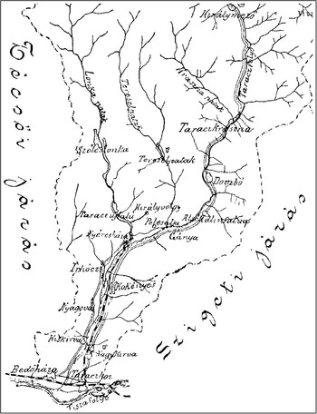
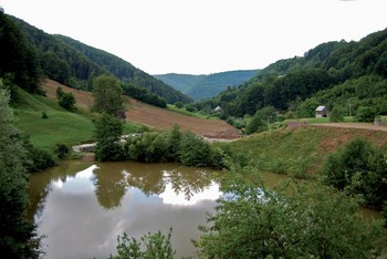
Locating the findspot was not an easy matter; Dr Josip Kobal’, however, located one map on which the name ‘Királyvölgy’ appears (fig 4).Footnote 18 Local people confirmed that salt mining had indeed taken place at the locality.Footnote 19 The spot where the trough is presumed to have been found is now occupied by a large and evidently deep pond (fig 5), presumably the abandoned Franz shaft, and though smaller pits in the vicinity contain pieces of wood, nothing could be seen in this water-filled depression.Footnote 20
Extract from the map of the Tarac district in Várady Reference Várady1901, showing the course of the lower Tarac(z) (Teresva), flowing into the Tisza at the south, with Királyvölgy shown here in the centre. Of the other place-names mentioned in this article, Nyéresháza is now Neresnitsa, Taraczujfalú is Novoselitsa and Gánya is Ganichi (Hanichi), of which the village of Solone (Szoláni/Szolenoje) is part. Map: Várady Reference Várady1901

The water-filled former mine-shaft at Királyvölgy. Photograph: author

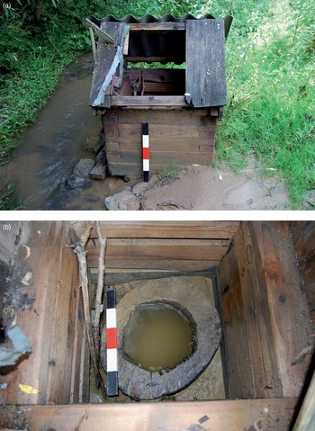
Salt springs lie in the immediate neighbourhood, one of them converted into a wood-lined well, as is common in this part of the world (fig 6); but it is apparent that no further information can be gleaned from this spot unless the mine were to be reopened – which is unlikely, since much more accessible and prolific salt sources occur in other parts of Ukraine. In the meantime, just downstream from the pond, construction is proceeding on a small hotel complex, probably to make use of the recuperative properties of the salt water from the stream.
Salt-water well at Királyvölgy. Photographs: author

Many former salt-production sites are known in this part of Ukraine; several of them were exploited industrially in the Austrian period down to 1918, while in other cases only a well-head is present. Wood was found to have been preserved at one other site, Tereblya, and samples for radiocarbon dating indicated a range of possible production dates in the late medieval and early modern period.Footnote 21
The objects in Sopron
The photograph from 1909 (fig 2) shows a number of different objects, mostly of wood. The most obvious is a ladder, but one can also make out a trough (sawn off obliquely at the end), some perforated wooden objects, a mallet, a block of salt with conical depressions in it, and various other objects – possibly a mass of rope lying on the salt block, as well as what seem to be other pieces of rock. The Preisig drawings (fig 1) show some of these, notably the trough, the ladder, the mallet, a broken wooden plank with square perforations and five pegs, and the rock salt. There is also another narrower ladder, a shovel and some curved pole-like objects (‘Haggen’). In the museum at Sopron, twelve objects are preserved, six of them being parts of the large ladder. The narrow ladder, shovel and the ‘Haggen’ are not present, nor is the rock salt.
The surviving objects are as follows:
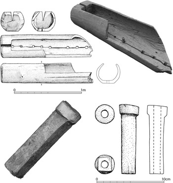
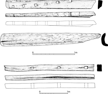
• Trough, incomplete, with eight square holes in the base (figs 1.1 and 7 (above)). Inv no. 2000.106.1 (Preisig Reference Preisig1877, figs 17 and 18). Length 1360mm; diameter 340mm; height 290mm; top opening 185mm where split, 165mm where not split; hole nearest complete end 28 × 24mm; depth of holes (thickness of base) 55–60mm. The trough is incomplete, having been sawn off straight down one side and obliquely across the base and the other side, presumably to facilitate extraction from the mine (it was evidently in this state when Preisig saw it). The wood is completely dried out and the trough has a large crack running along the length of the base. One peg is wedged into one of the holes; its base is apparently round, diameter 27mm. The surviving loose peg presumably belonged with the trough, though it might equally have come from the trough base fragment (see below).
• Peg (fig 7 (below)). Length 103mm; square section 17–20mm wide; diameter of collar 28mm; depth of collar 13–15mm; diameter of perforation 10mm. Preisig shows five pegs in the holes of the ‘Wasserverteilungsrinne’ (see below).
Fig 7Királyvölgy: trough (above) and peg (below). Graphics: Tamás Baranus

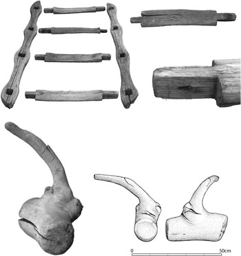
• Mallet (figs 1.5 and 8 (below)). Inv no. 2000.106.4 (Preisig Reference Preisig1877, figs 22 and 23). Length 330mm; diameter 140mm at one end, 125mm at the other.
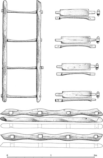
• Ladder consisting of two side pieces and four rungs (figs 1.4, 8 (above) and 9). The side pieces swell laterally at the points where the perforations for inserting the rungs were made. The rungs have tenons to fit into these perforations. The rungs are shaped (or worn) in a concave fashion. In the end of one of them an iron nail is present, probably to assist the reconstruction of the ladder when it was displayed in Budapest.
Fig 8Királyvölgy: ladder (above) and mallet (below). Graphics: Tamás Baranus
Fig 9Királyvölgy: ladder, with side pieces and rungs. Graphics: Tamás Baranus
Side pieces: inv nos 2000.106.5 and 6 (Preisig Reference Preisig1877, figs 26 and 27). Length 2365mm and 2335mm; width 185mm at widest points, thickness 90mm; holes for rungs 80 × 75mm, 80 × 70mm, etc.
Rungs: inv nos 2000.106.7, 8, 9 and 10. Two were measured (none had museum numbers or could otherwise be distinguished): length 92.5mm; width 14.5mm; thickness at one end 60mm: length 87.5mm; width 15.5mm; thickness at sides 70mm, on step 30mm.
• Ladder side piece (fig 10 (below)). Inv no. 2005.136.1 (not illustrated by Preisig). Has three square or rectangular holes and a possible fourth, cut off at the end. Length 1610mm; width 95mm; thickness 65mm, split; holes 40 × 25mm, 35 × 25mm, 60 × 35mm, mid-hole to mid-hole 490mm.
Fig 10Királyvölgy: trough base (above), channel (middle) and ladder side piece (below). Graphics: Tamás Baranus
• Trough base fragment (figs 1.2 and 10 (above)). Inv no. 2000.106.2 (Preisig 1877, figs 15 and 16, described as ‘Wasserverteilungsrinnen’, and shown with pegs in the holes). The identification as a trough base is based on the examination of several other troughs in Romania. Six holes survive and part of a seventh. Signs of shaping on the underside. Length 107mm; width (surviving) 100mm; thickness 40–55mm; distance between holes 120mm, 150mm, 125mm, 140mm, 150mm, 125mm; holes 27 × 22mm, 22 × 20mm, 22 × 23mm, 27 × 22mm, 25 × 23mm, 25 × ?mm.
• Channel (piece curved in cross-section) (fig 10 (middle)). Inv no. 2000.106.3 (not illustrated by Preisig). Length 1170mm; width (max) 150mm, curving; thickness of wood 25mm.


Radiocarbon dating
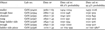
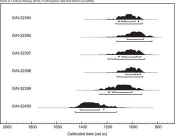
Samples were taken for radiocarbon dating and submitted to the Centre for Isotope Research, Groningen University (table 1; figs 11 and 12). The wood of the objects had completely dried out, even to the extent that no salt was evident, and there did not appear to have been any conservation treatment.

Probability distributions of the Bronze Age dates from Királyvölgy

Probability distribution of the medieval date from Királyvölgy

Remarkably, in spite of the chequered history of the objects, all the samples except the ladder side piece produced very similar radiocarbon ages, which gives one confidence in the integrity of the assemblage. Only the mallet is significantly earlier than the other finds. The combined value of the samples other than the mallet and ladder side piece is 2853 bp, giving ranges 1050–975 cal bc at 68.2% probability and 1120–930 cal bc at 95.4% probability (1120–970 cal bc at 85.2%).
Of very great interest is the fact that the dates fall in precisely the same time period as the bulk of those obtained at Băile Figa, in Transylvania, where the main period of usage for the wooden material fell between 3200 and 2800 bp. There are considerable differences in the dates for different parts of the site, with wattle constructions to the north falling after 1000 cal bc, but two of the three troughs can be dated to the period 1600–1400 cal bc and the third to the period around 1100–1000 cal bc, the latter according perfectly with the dates for the Királyvölgy objects. An identical trough from Valea Florilor, north of Turda, produced a date of 3000 ± 80 bp (1378–1128 cal bc at 68.2%, 1425–1012 cal bc at 95.4% probability).Footnote 22
The one date that is more recent comes from the fragmentary side of a putative ladder which, at 1170 ± 45 bp, falls in the medieval period at 720–980 cal ad (92.4% probability). At the Figa site there was also evidence for salt working in the early medieval period (and, indeed, in the Iron Age), albeit on a smaller scale than that in the Bronze Age. The medieval date from Királyvölgy is somewhat later than the dates from Figa, which fall between 400 and 600 cal ad, and earlier than a date from wood at the nearby salt mine of Tereblya, at 670 ± 15 bp (1280–1385 cal ad), but should probably be seen as part of the same pattern, whereby salt mining very probably continued at these sites from prehistoric to modern times.
Discussion
These remarkable results achieve additional importance when one considers the wider field of salt exploitation in central and eastern Europe in prehistoric times.Footnote 23 When we started work in Transylvania in 2002, knowledge was patchy and limited to a handful of well-known sites. We were aware, for example, that colleagues in Moldavia had discovered convincing evidence for Neolithic salt extraction, in the form of briquetage, salt wells with sites beside them and, in some cases, excavation material.Footnote 24 In Poland, some evidence for Neolithic exploitation of sources in the Wieliczka area had been known for some time, and evidence bearing on Bronze and Iron Age exploitation in other areas had also been published.Footnote 25 The evidence from Sachsen-Anhalt and elsewhere in Germany was well known,Footnote 26 as was the Bronze Age evidence from Hallstatt, in Austria,Footnote 27 or that from other areas of Europe such as France and Spain.Footnote 28 For the Iron Age, the Austrian sources (Hallstatt, the Dürrnberg) were highly informative. Evidence from North Sea and Atlantic coastal sites supported the notion that there was extensive salt production through evaporating sea water in both the Bronze and Iron Ages. In Italy, little was known a decade ago, but there is now considerable evidence from both the Tyrrhenian and Adriatic coasts for Bronze Age and Iron Age salt production.
For the rest of Europe, there was remarkably little known: no briquetage in eastern or southern areas, and no major sites beside salt wells or springs. Yet it was common to find assertions in the literature that the distribution of Bronze Age hoards was linked to the presence of salt sources, which enabled those who controlled them to become ‘rich’ through trading in salt.Footnote 29
All this changed in 2005, when Kavruk and I were fortunate enough to be taken to the salt stream at Băile Figa, in Bistriţa-Năsăud county, Romania, where a wooden trough had been removed earlier that year by Ioan Chintăuan,Footnote 30 and where large amounts of timber were visible in the stream. Survey and excavation work at the site since 2006 has uncovered an extraordinary amount of material relating to salt working, most of which can be dated to the Bronze Age, including three more troughs.Footnote 31 At least two other sites of the same type are located within ten kilometres of Figa, apparently using the same technology – and it is this same technology that seems to have been used at Királyvölgy, since the troughs are identical. It is also what was used at Valea Florilor, and yet another trough of the same kind is known from the salt mine at Ocna Dej, thirty kilometres west of Figa.Footnote 32
While much still remains to be elucidated about the way in which the troughs were used, it is clear that salt exploitation in northern Transylvania and, indeed, in the lands north of the Tisza, in present-day Ukraine, was a major industry in the Bronze Age. We cannot yet specify in what form salt was moved about, whether in containers or as cakes, since it is too soluble to leave traces on archaeological artefacts, other than wood; but it is highly probable that sources such as these from Transylvania would have supplied the salt-less areas of the Hungarian Plain to the west, notable for many large Bronze Age tells and a rich Bronze Age material culture.
Conclusion
Though salt was a commodity of major importance in prehistory, as in historic times, the evidence for its exploitation and movement has been elusive, other than in a few well-known sites and areas. In east-central Europe, that situation is changing. The work carried out in Transylvania represents a big step towards the goal of a fuller understanding of how salt was produced in that area in the Bronze Age. The results from Királyvölgy reported here indicate that the Carpathian area of Ukraine also took part in these developments. It is highly likely that further sites of Figa and Királyvölgy type remain to be discovered in the sub-Carpathian areas of Ukraine, Poland, Slovakia and Romania.
The remarkable set of events that led to the preservation of the Királyvölgy finds, the chance to study them after an interval of 100 years, and the establishing of their Bronze Age date, give hope that other objects connected with salt exploitation lie unappreciated in European museums. There is no question that salt was highly important in all ancient periods, including the Bronze Age; the archaeological demonstration of the fact is now established beyond doubt.
Acknowledgements
I am grateful to the Society of Antiquaries for the grant which enabled the visit to Ukraine in 2008 and paid for the drawings and some of the radiocarbon dates. Dr Josip Kobal’, of the Transcarpathian Museum in Uzhgorod, kindly guided Dr Kavruk and me to the Solotvino area and provided much assistance; he has also read the article in draft and suggested a number of important additions, including information on the geology of the area. Dr Carol Kacsó, of the Muzeul Judeţean de Arheologie şi Istorie in Baia Mare, informed me of the present whereabouts of the objects as a result of his correspondence with Attila Szemán in Sopron and (on the same day that the radiocarbon results were received) he also told me of his unearthing of the report on further finds from Solotvino (Aknaszlatina). Dr Attila Szemán, of the Központi Bányászati Múzeum in Sopron, provided every assistance in my visits there and supplied the account included in the Appendix here, while Professor Eszter Bánffy, of the Institute of Archaeology, Hungarian Academy of Sciences, smoothed the path towards the drawing, study and sampling of the objects and translated texts relating to the discoveries. Professor László Bartosiewicz kindly arranged for the scan of the map used for fig 4. The Director of the Központi Bányászati Múzeum, Dr Erzsébet Kovácsné Bircher, kindly gave permission for the sampling of the objects and Professor Andreas Lippert (University of Vienna) helped with the sampling of the trough. Dr Johann Reschreiter (Naturhistorisches Museum, Vienna) provided a photocopy and later a scan of the original Preisig report and Buschman text, as well as making helpful comments on the article in draft. Dr Marion Uckelmann dug out the information about Preisig and translated his account, which is in a rather archaic Austrian German, full of words specific to nineteenth-century mining. To all these individuals and institutions, I express heartfelt thanks.
The finds drawings are by Tamás Baranus, Archeotekt BT, Sopron, and the photographs were taken by staff of the Györ-Moson-Sopron county museums, through the kindness of Peter Polgár and the Director, Dr Imre Tóth. The present form of the illustrations is by Seán Goddard, Department of Archaeology, University of Exeter, to whom I offer many thanks. Dr Attila Szemán's Appendix was translated into English by Eszter Bánffy.
Appendix: The modern history of the Királyvölgy objects
First mentioned in 1402,Footnote 33 Királyvölgy might originally have been the name of an area renowned as a salt source, rather than of a settlement. If so, given that salt mining had been a royal monopoly since the time of the Arpad dynasty (from c ad 895), it must have been owned by the Hungarian monarch. Királyvölgy was named as a salt mine in production data published, along with those of several other Máramaros salt mines, by Istvan Lassú in 1825.Footnote 34 It is very likely that the mine mentioned by Lassú is the one in which the objects described here were found, when a new shaft was opened in 1817. Lassú and Fényes also give the name of the area in German as Königsthal, which seems to confirm that it belonged to the imperial treasury.
Elek Fényes records a new settlement in 1851, inhabited by 149 Roman Catholic Germans and thirty-six Greek Catholic Russians,Footnote 35 most of whom were royal woodcutters and miners. Maps from the end of the nineteenth and beginning of the twentieth centuries show a settlement called Gánya on the banks of the River Tarac (Teresva)Footnote 36 and a gazetteer identifies Királyvölgy with Gánya.Footnote 37 This identification cannot be regarded as certain, however. A geological map from 1885 clearly shows that it was the valley to the west of Gánya and the River Tarac that was then called Királyvölgy. This same map indicates the existence of a prolific salt mine and of prospection for salt. In 1907 it is mentioned as wooded land, on the borders of an estate; in other words, the name is now being used to describe a larger area.Footnote 38 In the light of all this, we can perhaps conclude that Királyvölgy was a salt-mining settlement separate from the village of Gánya, though located close to it.
The assemblage that was found here in 1817 was being exhibited in the mining section of the Millennium Exhibition in Budapest in 1896. The finds must then have belonged to the Hungarian State Geological Institute (Magyar Állami Földtani Intézet, hereafter MÁFI), founded in 1869, for they are described and illustrated in the guide to MÁFI's Geological Museum.Footnote 39
So-called ‘profile clearouts’ took place at MÁFI on two occasions, when all the non-geological material was filtered out and sent elsewhere, perhaps because of the shortage of storage space; the zoological and palaeontological material was passed to the Museum of Natural Sciences, for example. The first took place after 1945, and the second was connected with the centenary of the Institute at the end of the 1960s. It could have been in the course of these moves that the Királyvölgy finds were removed from MÁFI. Since the Central Mining Museum (Központi Bányászati Múzeum, hereafter KBM) was not founded until 1957, it could only have been in a position to receive the finds in the second wave of moves. It is possible, however, that the objects were given in the first wave of transfers to the Faculty of Mining, Smelting and Forest Engineering of Budapest Technical University, located in Sopron, and only later given to the KBM.
There is no mention of the receipt of the finds in the KBM archives, and the relevant MÁFI inventory book has been lost. The objects bore neither old nor new inventory numbers, so this was no help for identifying the finds. Given the length of time they belonged to the MÁFI collection, the lack of inventory numbers is surprising, but they might have been placed on detachable labels rather than marked on the objects themselves; neither were the objects given KBM inventory numbers for many years, which suggests that the transfer occurred in uncertain circumstances.
The objects were put in the museum store in Halasz utca. The possibility of identifying them with the Királyvölgy finds was dismissed at the end of the 1980s by the then museum directorate, which consisted solely of mining engineers. I was able to identify them later and give them inventory numbers, on the basis of the MÁFI museum guidebook, cited above; certain features of the wooden ladder and mallet were so remarkable that they could not be mistaken for anything else.
Not all of the objects visible in the museum photograph (see fig 2) came to the KBM; the rest had presumably already been lost or were never brought from the MÁFI collection. The photograph might show the objects as arranged for the Millennium Exhibition. The bast and other ropes are missing; the smaller piece of timber attached to them, which is probably similar to pieces known from medieval mining, can be identified as the saddle (seat) by which the miners entered the mine. The wooden shovels, which seem to be intended for use with one hand, are missing, as is the salt block lying below the trough. In the picture there are two objects in the form of crowbars, which, according to the description, were made of wood. These are also missing. However, the collection does contain fragments of other troughs.
In the picture, the ladder is shown in a vertical position but, as remarked by Sandor Schmidt, ‘ancient miners were not able to move about in comfort’;Footnote 40 and it is worth considering whether the broad rungs, carved flat to make stepping easier, could have been used in a horizontal position.Footnote 41 The distances between the rungs of about 0.5m would have made vertical use very difficult, but they would be appropriate for horizontal steps and so would provide a comfortable means of moving over the shaft.
Several of the descriptions report perforated wooden pegs in which lime bark was found, through which the water would have dripped (salt mining using water is a very ancient technique). The upper end of the surviving peg is round in cross-section. The lime bark is not present in the KBM collection.
At two points on the rungs fragments of iron nails can be seen. These contradict the published description according to which there was no metal in the shaft, only wood. One must assume that the iron nails were introduced in the course of display for the Millennium Exhibition in order to fix the parts of the ladder together.