Introduction
Amchitka Island is located in the centre of the Aleutian Island chain of Alaska, which divides the Bering Sea to the north from the Pacific Ocean to the south. The area is known for its harsh climate, characterised by frequent rain and high winds, as well as its prolific fishing grounds. In the span of human history, the island has moved from semi-permanent native settlements, through Russian occupation, wildlife refuge, military occupation, to a nuclear and subsequently, post-nuclear test site. Now, in the post-nuclear test era, Amchitka Island remains an environmental concern to many interested parties, including subsistence communities in the vicinity of the island, commercial fishing industries, the State of Alaska, and the United States Fish and Wildlife Service, due to radionuclides released in the subsurface with the underground blasts. In order to address these concerns, US Department of Energy (USDOE) has recently developed a plan for the long term stewardship of the island. The purpose of this paper is to summarise the history of the island, specifically with regards to its use as a nuclear test site, to summarise the results of investigative activities following testing, to summarise USDOE's plan for surveillance and monitoring, and to offer the authors' viewpoints on the long term stewardship of the island. Due to the environmental and health concerns regarding the potential impacts of the nuclear detonations, there is a need to provide a record of the activities, the results of assessments, information on the long term management plan, and a review of the remaining uncertainties for the polar community.
Site description
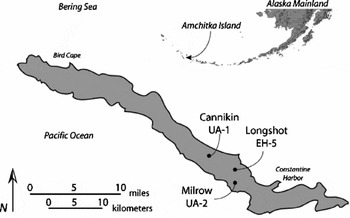
Amchitka Island, Alaska, is located at lat. 51.5°N and long. 179°E, and lies in the Aleutian Island chain, almost equidistant from the Alaskan and Russian mainlands (see Fig. 1). The long, narrow island is situated along a northwest-southeast plane. It is approximately 65 km (40 miles) long and 2 to 7 km (1–4 miles) wide (Merritt Reference Merritt, Merritt and Fuller1977a). It is part of the Rat Islands group of the Aleutians, which also includes the islands of Kiska, Segula, Rat, Khvostof, Davidof, Little Sitkin, and Semisopochnoi.
Map of Amchitka Island, Alaska showing the location of the three underground nuclear tests: Long Shot, Milrow and Cannikin.

The Aleutian Island chain was formed by the volcanic action of the Aleutian volcanic arc, where the islands exist as the peaks of a submerged mountain range lying parallel to a submarine trench, reaching a depth of up to 7600m. Amchitka, like most of the islands, is composed entirely of volcanic rocks, encompassing andesitic to latitic breccias, glassy breccias and basaltic pillow lavas (Carr and others Reference Carr, Gard, Bath and Healey1971; Merritt and Fuller Reference Merritt and Fuller1977; Eichelberger and others Reference Eichelberger, Freymueller, Hill and Patrick2002). The island is ‘part of a small crustal block being torn apart by oblique subduction – and therefore one of the least stable tectonic environments in the United States’ (Eichelberger and others Reference Eichelberger, Freymueller, Hill and Patrick2002). Earthquakes are common in this region, and earthquakes over magnitude 8 have been reported with relative frequency (Eichelberger and others Reference Eichelberger, Freymueller, Hill and Patrick2002). In 2003, there were two earthquakes over magnitude 7 centred in the Rat Islands; a 7.1 magnitude on 17 March and a 7.8 magnitude on 17 November (USGS 2003a, 2003b). In 2007, a magnitude 7.2 earthquake centred in the Andreanof Islands, 116 km from Amchitka Island, occurred on 19 December (USGS 2008).
The marine environment surrounding Amchitka is rich in nutrients as a result of cold ocean upwellings and hosts a rich and diverse ocean life. The region is important for subsistence and commercial catches, walleye pollock Theragra chalcogramma, pacific cod Gadus macrocephalus, halibut Hippoglossus stenolepis, rock sole Hippoglossus stenolepis, rockfishes Sebastes spp., salmon Oncorhynchus, and king crab Paralithodes camtschaticus. Many marine mammals, such as whales, seals, sea otters, and sea lions are prolific (Polar Research Board 1996). The island itself is host to 131 species of birds, some resident and some migratory, including species such as the Lapland larkspur, Calearius lapponicus, bald eagle Haliaeetus laucocephalus, peregrine falcon Falco peregrinus, and cormorants Phalacrocorax. The only terrestrial mammals historically present on the island are introduced species, the blue fox Alopex lagopus, which was introduced for economic endeavours and later eradicated, and the Norway rat Rattus norvegicus, which was accidentally introduced during World War II and still persists in great numbers on the island (Breechbill Reference Breechbill, Merritt and Fuller1977; Merritt Reference Merritt, Merritt and Fuller1977b; White and others Reference White, Williamson, Emison, Merritt and Fuller1977; Burger and others, Reference Burger, Mayer, Greenberg, Powers, Volz and Gochfeld2006a).
The total human population of the Aleutian Islands on 1 July 2007 was 7490 (US Census Bureau 2007). Though historically Amchitka Island has hosted a population, there has not been a non-military continuous occupation of the island since the late 1800's. The nearest current non-military population to Amchitka Island is located on Atka Island, approximately 450km (270 miles) away, with a population of 158 in 2006 (Merritt Reference Merritt, Merritt and Fuller1977a; US Census Bureau 2006).
There are currently 51 pending native claims referring to over 100 sites on Amchitka Island, generally related to cemetery and historical sites as provided for by the 1971 Alaska Native Claims Settlement Act (United States, Public Law 1971) and the Alaska National Interest Lands Conservation Act (United States, Public Law 1980). Due to the island's historical use as a nuclear testing facility, settlements would not be allowed on the island; however, the conveyance of these claims would alter the basis of the island's use and thus, the need for institutional controls on the island (USDOE 2008).
History
Pre-nuclear era (until 1965)
The Aleutian people settled in the Aleutian islands 10,000 years ago (Bernstein and others Reference Bernstein, Lungren, Brooke, Drinan, Flemming, Goldberg, Gromoff, Marutani and Mitchell1982). On Amchitka Island, archeological sites date back 3600 to 4600 years. Of the Rat Islands, Amchitka Island hosts the largest number of settlement sites, 73 of the total 86 in the island group, and estimates indicate that the island may have been home to more than 1,100 people (McCarthy Reference McCarthy, Merritt and Fuller1977).
Russian exploration into the Aleutians began in 1743, and the first documented account of Russian landing on Amchitka Island was Vorob'ev's exploration of 1760 to 1763. The pre-contact population of the Aleutians is estimated to have been between 12,000 and 15,000; this was reduced, by exploitation and disease to fewer than 4000 by 1830 (Merritt Reference Merritt, Merritt and Fuller1977b). On Amchitka Island, the Russian hunters forced the relocation of the island's inhabitants, and sometime after 1821, 85 Amchitkans were moved to Adak and Atka. Some of the Amchitkans may have been returned sometime after, but records indicate that the last permanent native settlement on Amchitka was abandoned by 1849 (Merritt Reference Merritt, Merritt and Fuller1977b; Kohlhoff Reference Kohlhoff2002).
The United States purchased the Alaskan territory from Russia in 1867, by which time, the Aleut population had declined to around 2,000. In 1913, President Taft signed an executive order that created the Aleutian Islands Reservation, whereby the islands were designated ‘as a preserve and breeding ground for native birds, for the propagation of reindeer and fur bearing animals, and for the encouragement and development of fisheries.’ However, the order also stated that ‘[t]he establishment of this reservation shall not interfere with the use of the islands for lighthouse, military, or naval purposes. . . .’ In 1940, the reserve was renamed the Aleutian Islands National Wildlife Refuge (Merritt Reference Merritt, Merritt and Fuller1977b).
In June 1942, World War II came to Alaska when the Japanese bombed military installations in Dutch Harbor and occupied Attu and Kiska Islands. These attacks and invasions by an enemy on US soil prompted the Aleutian campaign, involving US and Canadian troops, of 1942 and 1943 (Merritt and Fuller Reference Merritt and Fuller1977; Bernstein and others Reference Bernstein, Lungren, Brooke, Drinan, Flemming, Goldberg, Gromoff, Marutani and Mitchell1982; Garfield Reference Garfield1995; Kohlhoff Reference Kohlhoff2002). During the Aleutian campaign, the Aleutian population and culture was further eroded and irrevocably damaged by the US government's relocation and internment of Aleuts and Pribilof Islanders from 1942 to 1943; following internment, many villages were never re-established (Bernstein and others Reference Bernstein, Lungren, Brooke, Drinan, Flemming, Goldberg, Gromoff, Marutani and Mitchell1982).
On 12 January 1943, 2100 American engineers and army troops landed on Amchitka Island following scouting activities in December 1942, which included the bombing of the abandoned village. A landing strip was constructed soon after, marking the beginning of the island's use as a military site. An estimated maximum 15,000 military personnel would eventually be stationed at Amchitka prior to military evacuation in 1950. (Merritt Reference Merritt, Merritt and Fuller1977b; Garfield Reference Garfield1995; USDOE 1998).
Nuclear Era
Amchitka Island was used as an underground test site from 1965 until 1971. The energy released in the three tests conducted there represents roughly 16% of the energy released during the entire US underground nuclear testing programme, and the Cannikin test was the largest ever detonated in the programme (US Congress 1989; Robbins and others Reference Robbins, Makhijani and Yih1991; Norris and Arkin Reference Norris and Arkin1998; USDOE 2006).
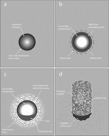
In general, when an underground nuclear device is detonated, the billions of atoms contained in the bomb release their energy nearly instantaneously, creating pressures of several billion Pascals and temperatures around 100 million °C. Surrounding rock and metal bomb material are vaporised, and the gas pressures created will begin to form a cavity. Seismic waves similar to those released by an earthquake will propagate outward from the detonation. Within a few seconds after detonation, molten rock surrounding the detonation cools and solidifies in the bottom of the cavity. Eventually, gas pressures decrease in the cavity to a level that will no longer support the overburden. At this point, the overlying rock will break and collapse into the cavity, creating rubble and a chimney, which may or may not reach ground surface. This collapse may take hours to months after detonation. Much of the radioactive material released by the detonation will become trapped in the vitric, or cooled molten, material, however, some will partition between gas, liquid, and solid phases underground. Some radionuclides are highly absorbed onto rubble and other rock material, but some of the more soluble nuclides may infiltrate into groundwater and be transported (US Congress 1989; IAEA 1998a). This process is illustrated in Fig. 2.
Illustration of the phases of an underground nuclear detonation (a) after tens of microseconds, (b) after hundreds of microseconds, (c) after tens of milliseconds, (d) after minutes to hours. Adapted from IAEA 1998b.

Long Shot
In 1963, the US and Soviet governments signed the Limited Test Ban Treaty, which prohibited above ground and underwater testing of nuclear weapons. However, because at the time, there was no existing technology to detect underground nuclear tests, this treaty did not limit underground testing. The US Department of Defense (DOD) initiated the Vela Uniform Project in an attempt to develop seismic detection technology that would enable the detection of underground detonations. Under this project, several underground tests were performed in the US between 1963 and 1971, most of them at the Nevada Test Site. However, Amchitka Island became the location of one of these tests (Merritt and Fuller, Reference Merritt and Fuller1977; US Congress 1989; Kohlhoff Reference Kohlhoff2002; USDOE 2006).
On 29 October 1965, the 80 kiloton nuclear bomb known as Long Shot was detonated at a depth of 720 m (2350ft) below ground surface. Long Shot was conducted as a part of the Vela Uniform project, and was conducted shortly after an 8.7 magnitude earthquake in the vicinity. The main impetus for the shot was to determine whether or not the then current monitoring technology could differentiate between natural seismic activity and an underground nuclear explosion. The DOD conducted the Long Shot test and had initially planned to conduct the test in secret; however, due to the statutory responsibility of the Atomic Energy Commission (AEC), the AEC involvement was required and the public was informed prior to the test (Merritt and Fuller Reference Merritt and Fuller1977; Kohlhoff Reference Kohlhoff2002; USDOE 2006).
Milrow
In 1966, the AEC began to search for alternative test sites for high yield weapons, as population and an increasing number of high rise buildings in Las Vegas, Nevada was beginning to cause safety concerns for the use of the nearby Nevada Test Site. Amchitka Island was selected as an alternate test site, and the United States Geological Survey (USGS) began geological investigations that year on behalf of the AEC at six sites on the island (named Sites A, B, C, D, E, and F) (Merritt Reference Merritt, Merritt and Fuller1977b; Kohlhoff Reference Kohlhoff2002).
The Milrow test shot was detonated at Site B of Amchitka Island on 2 October 1969 at a depth of 1218m (4000ft) below ground surface. The approximately 1 megaton nuclear device detonated was conducted as a seismic calibration test to determine if Amchitka Island could sustain the detonation of a higher yield Spartan anti-ballistic missile warhead (Fuller and Kirkwood Reference Fuller, Kirkwood, Merritt and Fuller1977; US Congress 1989).
Cannikin
Following the Milrow test shot, the AEC determined that Amchitka Island could indeed sustain the detonation of a higher yield weapon, and planning for the larger test shot, Cannikin, under the Safeguard Ballistic Missile Defense Program ensued. In 1970, the National Environmental Policy Act (NEPA) was passed, and as a result, the Cannikin test required an Environmental Impact Statement (EIS) as part of the planning. There was much political debate and public protest to the test, as described by Kohlhoff (Reference Kohlhoff2002), including two law suits and the formation of Greenpeace and their subsequent purchase of a boat and near attempt to witness the detonation. However, despite protests, on 6 November 1971, the Cannikin test detonated an approximately 5 megaton Spartan warhead at a depth of 1790m (5875ft) below ground surface (US AEC, 1972; Claassen, Reference Claassen1978; US Congress, 1989; USDOE, 2006).
Unique to the Cannikin test shot, a re-entry drill hole, UA-1-P1, was advanced between 1971 and 1972 to investigate the hydrologic processes and radionuclide distributions in the cavity and chimney following the detonation. During the drilling operations, approximately 4000m3 of radioactive gases, primarily consisting of krypton, tritium, and carbon, were released to the atmosphere. Subsequent investigations indicated no evidence of surface deposition of these radionuclides. The water used to decontaminate equipment was injected into the well, and all tools, valves, and pipes suspected to have been contaminated were placed or cut and placed into the well cellar, and subsequently buried and sealed with 1.2m of concrete (Claassen Reference Claassen1978; Faller and Farmer, Reference Faller and Farmer1997; Dasher and others Reference Dasher, Hanson, Read, Faller, Farmer, Efurd, Kelley and Patrick2002).
Post testing assessment
A review of site assessments, as they pertain specifically to the underground nuclear tests detonations, is included in the following. This review is limited to the assessments regarding the detonations, and does not include assessments of the impacts of other human activities and military occupations nor the site preparation and support activities related to the nuclear tests.
Initial post shot assessments: Long Shot
Geological investigations conducted by the USGS from 1963 until shortly after the Milrow test are summarised by Carr and others (Reference Carr, Gard, Bath and Healey1971). No geological impacts associated with the Long Shot and Milrow tests were observed. However, the authors note that ‘a few minor slumps or rock falls occurred along the sea cliffs.’ An earlier report by McKeown and others (Reference McKeown, Young, Williams and Brethauer1967) reported more specific observations regarding the immediate observable effects of the Long Shot test. They noted fractured ground, mostly in unconsolidated ground, as far as 2255m (7400ft) away from surface ground zero (SGZ), tilted ponds, ponds and streams with slumped banks, and several mud geysers.
Following the Long Shot detonation, sampling revealed leakage of radioactive hydrogen (tritium), iodine-131, and krypton-85 to the surface and near surface environment, assumed to be attributable to the upward migration of radioactive gases due to expansion and displacement from cavity collapse and/or displacement due to groundwater infiltration. Initially, 131I was detected in a slump pond 100m from the Long Shot SGZ in November 1965. Tritium was detected in several slump ponds and drainage ditches in the vicinity of SGZ, and was monitored until May 1969 by contractors for AEC. A maximum tritium concentration of approximately 16,600 pCi/L was detected in a ditch 60m east of SGZ in September 1966. This concentration was higher than the background at that time, however, was less than the drinking water limit for tritium of 20,000 pCi/L (Castagnola Reference Castagnola1969; Seymour and Nelson Reference Seymour, Nelson, Merritt and Fuller1977; Faller and Farmer 1998; Dasher and others Reference Dasher, Hanson, Read, Faller, Farmer, Efurd, Kelley and Patrick2002; USDOE 2006).
Amchitka Bioenvironmental Program
As a result of the status of Amchitka Island as part of a national wildlife refuge, the Amchitka Bioenvironmental Program was created by the AEC and administered through the Nevada Operations Office of the AEC, now known as the USDOE, in order to predict and mitigate the effects of the Milrow and Cannikin tests, to establish baseline information prior to the tests, and to document their impacts. The studies conducted under this programme began in 1967, following the Long Shot detonation, and ended in 1973 after the Cannikin detonation. The results are summarised in a series of papers published under the title The environment of Amchitka island, Alaska (Merritt and Fuller Reference Merritt and Fuller1977). The impacts to the environment of the Milrow and Cannikin tests are summarised in the following.
Milrow
The Milrow detonation resulted directly in notable terrain changes. Rockfalls near the Amchitka coasts moving 6900m3 of material occurred within 4km of SGZ. A fault shift caused an average 12cm (5in) uplift of approximately 4ha along an intertidal bench along the Pacific Ocean side of the island at Duck Cove. Tears and fractures in the peat mantle occurred surrounding SGZ and explosive disruption of natural tundra mounds were documented. Near SGZ, the collapse of the chimney caused tilting and fissure openings in the bottoms of two small lakes, which partially drained (Burkett Reference Burkett, Merritt and Fuller1977; Fuller and Kirkwood Reference Fuller, Kirkwood, Merritt and Fuller1977).
These terrain and surface changes resulted in impacts to both the terrestrial and marine biota of Amchitka Island. The drainage of the small lakes resulted in impacts to the freshwater fish populations and biota. Pressure shock killed many threespine sticklebacks Gasterosteus aculeatus in those lakes, and some fish were thrown from the water during the blast. In the uplifted intertidal zone, massive algae and invertebrate kills were documented. It was generally thought that these impacts would not be permanent; however, there was a permanent shift in the ecological system of the uplifted region. There were no observed impacts of Milrow on the bird populations of the island, nor on the marine fish or marine mammal populations, although weather prevented many of the planned monitoring activities following the blast. No evidence was found of radionuclides in marine, biota, or freshwater environmental samples following the test (Burkett Reference Burkett, Merritt and Fuller1977; Valdez and others Reference Valdez, Helm, Neuhold, Merritt and Fuller1977; White and others Reference White, Williamson, Emison, Merritt and Fuller1977; Lebednik and Palmisano Reference Lebednik, Palmisano, Merritt and Fuller1977; Simenstad and others Reference Simenstad, Isakson, Nakatani, Merritt and Fuller1977; Seymour and Nelson Reference Seymour, Nelson, Merritt and Fuller1977; Fuller and Kirkwood Reference Fuller, Kirkwood, Merritt and Fuller1977).
Cannikin
The Cannikin detonation caused rock and turf falls totalling 30,000m3 of material along the Bering Sea coast and 5000 m3 along the Pacific coast. These occurred along lines of an estimated 7.5km and 2km, respectively. Fault shifting was far more severe than that associated with the Milrow test. On the Bering Sea coast, near Sand Beach Cove, a 1.9km section of intertidal bench was uplifted between 25 and 107cm and additional 3km of bench was uplifted 18cm. Terrain disturbances, in the form of extensive surficial cracks, tears, and scarps, occurred at distances up to 2.5km from SGZ. Six small lakes and ponds, up to 1.2km from SGZ, were either completely or partially drained due to tilting and/or bottom fissuring. A large subsidence crater was formed during chimney collapse, covering an area of 12ha with a maximum depth of 9.45m. This crater interrupted the flow of White Alice Creek, which filled the crater during 13 months following the Cannikin detonation, before normal flows resumed in the creek. This resulted in the formation of Cannikin Lake, which is the largest and deepest lake on Amchitka Island (Burkett Reference Burkett, Merritt and Fuller1977; Fuller and Kirkwood Reference Fuller, Kirkwood, Merritt and Fuller1977).
There were massive fish kills of both marine and freshwater species associated with the Cannikin detonation. Within a 1.8km radius of SGZ, pressure shocks, stranding as a result of drainage, and explosive throwing from the water, killed approximately 10,000 threespine sticklebacks and 700 landlocked dolly varden Salvelinus malma. Populations recovered in all but the permanently drained surface waters. Stranding on uplifted intertidal benches and/or shock waves killed 300 rock greenling Hexagrammos lagocephalus, and rock sole and rock greenling catches were observed to have been impacted for a period of approximately 1 year after the test. Rapid pressure changes and rock falls killed 12 sea otters and 4 harbour seals that were recovered following testing. It was estimated that several hundred sea otters were killed by the test; no estimated kills on seal populations were ever made. Massive algae and invertebrate kills were observed in the uplifted intertidal benches, and permanent shifts in the ecological communities resulted from the vertical displacements. Fifteen birds were found killed from pressure shock in the water and/or vertical acceleration on land, and it was estimated that many more were actually impacted. Several bald eagle nests and peregrine falcon eyries were destroyed and/or damaged by the test, though it was estimated that this damage would not have long term consequences (Burkett Reference Burkett, Merritt and Fuller1977; Valdez and others Reference Valdez, Helm, Neuhold, Merritt and Fuller1977; White and others Reference White, Williamson, Emison, Merritt and Fuller1977; Lebednik and Palmisano Reference Lebednik, Palmisano, Merritt and Fuller1977; Simenstad and others Reference Simenstad, Isakson, Nakatani, Merritt and Fuller1977; Seymour and Nelson, Reference Seymour, Nelson, Merritt and Fuller1977; Fuller and Kirkwood Reference Fuller, Kirkwood, Merritt and Fuller1977).
Long term hydrological monitoring
The USGS installed several shallow groundwater wells in 1971 following the documented tritium release to the surface associated with the Long Shot test. The United States Environmental Protection Agency (EPA) began a sampling these wells and analysing for tritium and gamma-ray emitters in 1977 and lasting until 1997 as part of the Long term hydrological monitoring programme. No gamma ray emitters were detected, and tritium was found in the vicinity of Long Shot SGZ, with the zone of maximum contamination between 60 to 100m (200 and 300ft). During the years of monitoring, tritium concentrations were decreasing, due to decay and dilution (Faller and Farmer Reference Faller and Farmer1997).
Investigations of potential surface leakage of radionuclides
In 1996, Greenpeace collected samples of aquatic biota from Amchitka Island with the aim of investigating the potential surface release of radionuclides. In 1996, Miller and Buske reported that the samples indicated the release of americium-241 and plutonium-239 + 240 in the vicinity of the Cannikin test shot. In 1998, Buske and Miller (Reference Buske and Miller1998) reported on additional analyses and indicated the potential release of americum-241 from the Long Shot, Milrow, and Cannikin test shots.
As a result of the 1996 report, sampling excursions occurred in 1997 and 1998 jointly by the US EPA, USDOE, Alaska Department of Environmental Conservation (ADEC), the Aleutian and Pribilof Islands Association (APIA), Greenpeace, and the University of Alaska Fairbanks. These sampling efforts included water, vegetation (freshwater moss and marine algae), lichen, soils, sediments, and freshwater fish both from the watersheds of the three test shots as well as control samples. The samples were analysed for tritium, gamma and alpha emitters, and the ratio of plutonium-240 to plutonium-239, which can be compared to global fallout and regional means for the latitude. The investigations did not indicate any release of tritium, radioactive americium, nor other radionuclides from the test cavities to the surface terrestrial or freshwater environments, other than those associated with the documented release of tritium from the Long Shot test (Dasher and others Reference Dasher, Hanson, Read, Faller, Farmer, Efurd, Kelley and Patrick2002; USDOE 2006).
Groundwater modelling
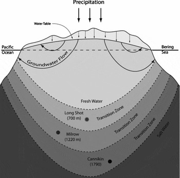
The conceptual model for the transport of radionuclides released in the subsurface by the detonations to the surface environment is illustrated in Fig. 3. In this model, mobile radionuclides, if present, would be transported with groundwater flow from the test cavities to the ocean floor. The results of early predictive groundwater modelling and radionuclide transport for the Cannikin test shot were reported by Fenske (Reference Fenske1972). The model predicted that groundwater from the Cannikin shot chimney should be transported to the Bering Sea ocean floor with an average groundwater travel time of more than 3000 years, where the model assumed dilution and mixing in the ocean following seepage to the sea floor. A later model by Wheatcraft (Reference Wheatcraft1995), determined a travel time for water from the Long Shot cavity to the ocean floor of between 800 and 1700 years, depending largely on the location of the freshwater/saltwater transition zone, a region characterised by an increasing salinity with depth. The model considered a spatially and temporally constant recharge and a single hydraulic conductivity for an isotropic, homogeneous subsurface. Wheatcraft suggested that the model could be improved by consideration of a layered geologic system.
Conceptual model of the Amchitka Island hydrology. It is noted that the depth of the transition zone varies widely amongst the three test sites. For a more detailed discussion of island groundwater hydrology, see Fetter Reference Fetter2001.

Hassan and others (Reference Hassan, Pohlmann and Chapman2002) modelled the radionuclide transport to determine travel times and potential seepage locations from all three test shots in an effort to improve risk assessments. Their models were two dimensional and included extensive uncertainty analyses using Monte Carlo techniques. The uncertainties considered included: hydraulic conductivity, recharge, fracture porosity, dispersivity, as well as less detailed analyses regarding uncertainties in heat driven flow and three dimensional considerations. The models considered a homogeneous hydraulic conductivity with a range of values. Analyses of the results indicated that the shortest peak arrival time to seepage locations from the test cavities for tritium of 20 to 30 years for Long Shot and 100 to 125 years for Milrow and Cannikin. The shorter travel time associated with Long Shot resulted from estimates that placed the Long Shot detonation above the freshwater/saltwater transition zone, while the Milrow and Cannikin detonations were assumed to have occurred in the transition zone. The mass breakthrough times for test related radionuclides was over 2,200 years for nearly all of the Monte Carlo realisations at the three test sites. The model was determined to be highly sensitive to fracture porosity, diffusion of radionuclides into the matrix rock, and uncertainties in the locations of the transition zones for the three test locations.
The Consortium for Risk Assessment with Stakeholder Participation (CRESP) began investigations aimed at addressing these and other uncertainties regarding the transport of, and health risks associated with, the radionuclides in the subsurface at Amchitka Island in 2002. As part of the CRESP investigations, magnetotelluric (MT) surveys were performed across transects intersecting each of the three test sites in 2004. The results of the MT surveys resulted in improved estimates of the depths to the transition zone and the variation of effective porosity with depth. The MT survey indicates that all three of the test shots were located in the transition zone. Unsworth and others (Reference Unsworth, Soyer, Tuncer, Wagner and Barnes2007), report an effective porosity of 10–20% at the ground surface, decreasing with depth to 1–3% at 3000m below ground. These authors indicated that the location of the test shots in the transition zone, as opposed to the saltwater zone, would result in shorter path lengths to the ocean floor, hence reducing travel times. However, the higher porosities determined by MT would result in longer ultimate travel times (Powers and others Reference Powers, Burger, Kosson, Gochfeld and Barnes2005; Unsworth and others Reference Unsworth, Soyer, Tuncer, Wagner and Barnes2007). It is noted, however, that the large scale of the MT measurements (3km depth) allows large scale interpretations of effective porosities in the subsurface, however, the results of MT investigations cannot be applied to interpret fluctuations in porosities which will occur with geologic layers in the subsurface rock.
As part of the CRESP science studies, groundwater modelling with improved data on the transition zone depths and bathymetry were performed for the Long Shot test site (Powers and others Reference Powers, Burger, Kosson, Gochfeld and Barnes2005) and the Cannikin site (Wagner Reference Wagner2007). Various simulations performed in these analyses included consideration of isotropic subsurface, anisotropic subsurface at ratios of 1:2 and 1:10, longitudinal dispersivity, and varying rates of recharge to the island from precipitation. No retardation effects on radionuclide transport due to diffusion and sorption of radionuclides into matrix rock or decay were considered. Groundwater travel times at the Long Shot site from the test cavity to the ocean floor ranged from 1,400 to 4,700 years for the various scenarios considered. However, previous investigations indicate that the Long Shot detonation occurred in an andesite sill, a geological unit characterised by a high hydraulic conductivity due to an extensive fracture network. When the influence of the andesite sill was considered in the model, the groundwater travel time ranged from 400 to 1,400 years. Groundwater travel times at the Cannikin location from test cavity to ocean floor ranged from 2,100 to 4 million years. While these estimates of groundwater flow are similar to the 2002 model, Wagner (2002) notes that this commonality is the effect of different considerations of effective porosity and anisotropy. The 2002 model considers a low porosity as compared to the 2007 model, which leads to shorter transport times, while the 2002 model also considers a higher anisotropy, which leads to longer transport times as compared to the 2007 model. Therefore, further investigations to reduce these uncertainties were recommended (Wagner Reference Wagner2007).
Diffusion coefficients and porosities of samples of rock from pre-shot exploratory cores, most in the vicinity of the Cannikin test shot, have been measured in laboratory experiments by the authors (Benning Reference Benning2008). The results of the experiments indicate that on a finer scale than indicated by MT investigations, porosities vary significantly with geologic layers from approximately 9% for andesites, to 12–14% for basalts, to 13–29% for breccias, with low porosities layers interspersed with high porosity layers throughout the depth of a core. The diffusion coefficients correspondingly range by more than two orders of magnitude for the low and high porosity samples. These results indicate that, as suggested by Wheatcraft (Reference Wheatcraft1995), a layered subsurface system is a more likely scenario for modelling the transport of radionuclides through Amchitka Island's subsurface. The andesite sill layer at the Long Shot test site modelled by Wagner (Reference Wagner2007) indicates that this layer represents a potential preferential flow path due to its extensive fracture network, and when this layer is considered, short groundwater travel times from test cavity to ocean floor result. The low porosity and low diffusion coefficient for andesite indicates that there would be relatively little retardation and storage of radionuclides in this layer, and thus radionuclide travel times in this layer would be much closer to groundwater travel times.
Hassan and Chapman (Reference Hassan and Chapman2006) revised their 2002 statistical groundwater model using data derived in the CRESP studies to reduce uncertainties in the model. The 2006 model incorporated the results of the MT surveys regarding the depths of the transition zones and effective porosities at the three sites, as well as bathymetric data summarised in Powers and others (Reference Powers, Burger, Kosson, Gochfeld and Barnes2005). The additional data was determined to have dramatically reduced uncertainties in the 2002 model. The groundwater velocities were decreased by approximately an order of magnitude, as a result of the increased effective porosity provided by the MT surveys; and for all realisations, the travel times were greater than the 2,200 year modelled time scale.
Screening risk assessment
The USDOE prepared a draft screening risk assessment report in 2005 as part of the site investigations of the long term management of the site. However, the ADEC and APIA did not accept the results of this assessment, and instead requested that USDOE efforts should focus on the development of the long term management plan. As stated in the later USDOE report (USDOE 2008: 3–17): ‘ADEC and the Stakeholder group have serious concerns regarding the human health risk assessment and lack of ecological risk assessment. If discussion of the risk assessment is included, a clear statement should precede these sections stating that ADEC and the Alaska Stakeholder group do not concur or approve of the risk assessment.’
Amchitka independent science assessment
The CRESP science plan for Amchitka Island was developed through active participation and collaboration of the major stakeholder parties for the island through all stages of planning and research (Burger and others Reference Burger, Gochfeld, Kosson, Powers, Friedlander, Eichelberger, Barnes, Duffy, Jewett and Volz2005). The development of a conceptual site model was a necessary step to defining the problem and identifying the potential receptors and stakeholders (Burger and others Reference Burger, Mayer, Greenberg, Powers, Volz and Gochfeld2006a). The major stakeholders concerned with the potential release of radionuclides to the environment from the Amchitka underground nuclear tests include: the Aleutian Pribilof Islands Association (APIA), the Alaska Department of Environmental Conservation (ADEC), US Fish and Wildlife Service (USFWS), and the US Department of Energy (DOE). The major objectives of the science plan were to assess the current safety of consumption of subsistence and commercial food sources derived from the environment surrounding Amchitka, to provide baseline data and to promote scientific studies to reduce the level of uncertainties in the transport modelling and risk assessment of radionuclides released underground at Amchitka (Burger and others Reference Burger, Gochfeld, Kosson, Powers, Friedlander, Eichelberger, Barnes, Duffy, Jewett and Volz2005; Burger and others Reference Burger, Gochfeld, Powers, Kosson, Halverson, Siekaniec, Morkill, Patrick, Duffy and Barnes2007a). The results of the execution of the science plan are summarised in the 2005 report entitled ‘Amchitka independent science assessment’ (Powers and others Reference Powers, Burger, Kosson, Gochfeld and Barnes2005). The results of some of the physical assessments are summarised in the preceding section, and the biological components are summarised in the following and described in several papers (Burger and others Reference Burger, Gochfeld, Burke, Jeitner, Jewett, Snigaroff, Snigaroff, Stamm, Harper, Hoberg, Chenelot, Patrick, Volz and Weston2006b, Reference Burger, Jewett, Gochfeld, Hoberg, Harper, Chenelot, Jeitner and Burke2006c, Reference Burger, Gochfeld, Powers, Kosson, Halverson, Siekaniec, Morkill, Patrick, Duffy and Barnes2007a, Reference Burger, Gochfeld and Jewett2007b, Reference Burger, Gochfeld and Jewett2007c, Reference Burger, Gochfeld, Kosson, Powers, Jewett, Friedlander, Chenelot, Volz and Jeitner2007d).
Since the major concern of several stakeholders was the potential for radionuclide contamination of biota in the marine environment surrounding Amchitka, CRESP researchers held several meetings in the Aleut villages and with other natural resource trustees. These meetings served to identify the species that stakeholders were most concerned about, to seek additional input concerning other biota to sample, and to solicit any other views about the sampling plan. These meetings resulted in changes to the initial sampling plan, as well as the inclusion of Aleuts on the expedition to collect samples in their traditional manner (Burger and others Reference Burger, Gochfeld, Powers, Kosson, Halverson, Siekaniec, Morkill, Patrick, Duffy and Barnes2007a, Reference Burger, Gochfeld and Jewett2007b).
The sampling plan included collecting specimens from the marine environment around the three Amchitka test shots and at a reference site (Kiska Island). Specimens collected in the summer of 2004 included in the marine biota, representatives of different trophic levels (kelp, invertebrates, fish, birds) and subsistence and commercial foods. One important aspect of the sampling plan was that several different species were collected at each trophic level to ensure that radionuclide bioaccumulators were included. The inclusion of Aleuts as participants in the sample collection ensured that some biota were collected in the traditional manner from typical fishing and hunting locations. Their inclusion also allowed the expedition to add traditional foods not previously included in the initial sampling plan. Further, the Aleut researchers could report the results back to their villages from first-hand experience.
Salinity measurements of the ocean floor conducted under this programme indicated that there was no major freshwater discharge, which would occur if there were preferential flow from the island's subsurface to the ocean floor through faults, and hence no major preferential pathway for radionuclide transport was detected. The studies, however, also revealed regions of ocean floor adjacent to the Cannikin and Long Shot test locations with large sediment accumulations. These deposits, which in previous risk assessments had been assumed not to exist, have potential to accumulate radionuclides, if there were seepage from the subsurface, whereupon there would be potential to enter the food chain via accumulation of exposed sedentary biota such as kelp (Powers and others Reference Powers, Burger, Kosson, Gochfeld and Barnes2005).
The results of the 2004 sample analyses and risk evaluations indicated that there was no current risk from radionuclides to humans or environmental receptors from the underground testing at Amchitka Island (Burger and others Reference Burger, Gochfeld and Jewett2007c, Reference Burger, Gochfeld, Kosson, Powers, Jewett, Friedlander, Chenelot, Volz and Jeitner2007d, Reference Burger, Gochfeld, Kosson, Powers, Friedlander, Stabin, Favret, Jewett, Snigaroff, Snigaroff, Stamm, Weston, Vol and Jeitner2007e). None of the biota sampled in 2004 displayed any detectable amounts of iodine-129, cobalt-60, europium-152, strontium-90, or technetium-99. Some samples contained trace amounts of americium-241, uranium-236, plutonium-239 and -240, and caesium-137; and nearly all samples contained uranium-234, -235, and -238. Comparison of Amchitka Island samples to samples collected from the reference island, Kiska, and other global reference locations did not indicate that the presence of these radionuclides could be associated with the Amchitka Island nuclear tests. However, the analyses indicated that plutonium and uranium tended to concentrate in algae, kelp, and filter feeders, such as jingles Pododesmus macroschisma, while the marine fish, especially those on higher trophic levels tended to concentrate caesium. Thus, CRESP recommended that the long term stewardship plan should include monitoring of both sedentary and mobile biota that represent different levels on the food chain, commercial fish, and subsistence species (Burger Reference Burger2007).
The results of the radionuclide analyses of the full suite of biota also provided data to assess the current risk to commercial and subsistence foods. However, further radionuclide analyses were required to provide enough data to identify the biota at each trophic level that were the greatest accumulators of radionuclides, since these would provide the earliest warning of any potential problems (Burger and others Reference Burger, Gochfeld, Kosson and Powers2007f). CRESP recommended two species of kelp, Fucus and Alaria fistulosa, a filter feeder invertebrate (blue mussel Mytilus edulis), dolly varden as a commercial and subsistence fish that is anadramous, black rockfish Sebastes meanops because of its subsistence value, pacific cod and halibut as top level fish predators of subsistence and commercial value, and glaucous-winged gull (Larus glaucescens) because it is local, long-lived, and the eggs are a subsistence food (Powers and others Reference Powers, Burger, Kosson and Gochfeld2006, Burger and others Reference Burger, Gochfeld, Kosson and Powers2007f). This combination of species represents key trophic levels, as well as commercial and subsistence foods.
Long term stewardship
At many USDOE sites throughout the United States, technological and economic limitations prevent cleanup activities from achieving a state that would allow unrestricted access and use of the site in a manner that would still ensure the health and safety of current and future generations. For some sites, particularly those that are a legacy of the USDOE nuclear weapons programmes, the nature of the contaminants themselves inhibits feasibility of remediation. Many radionuclides, for example, have very long half lives and thus are very persistent in the environment; furthermore, many decay into radioactive daughter products that also pose health hazards. For these sites, the USDOE implements ‘long term stewardship’ or ‘long term management’, a plan of actions designed to minimise current and future human health risks associated with remaining (residual) contamination at these sites (USDOE 1999; USDOE 2001).
The term ‘stewardship’ is defined by the USDOE as ‘activities necessary to maintain long-term protection of human health and the environment from hazards posed by residual radioactivity and chemically hazardous materials’ (STGWG 1999). In practice, this entails all of the activities required to ensure the protection of human health and the environment for a site after remediation is ‘complete’, economically and technically feasible options for remediation are exhausted, or further remedial options would present increases in risks to human health (USDOE 1999). Several groups provide information and recommendations as to how long term stewardship should be handled at these sites, such as the USDOE (USDOE 1999; USDOE 2001), the National Research Council (NRC) (NRC 2000), and the State and Tribal Government Working Group (STGWG) (STGWG 1999). Others also provide additional discussions and recommendations regarding long term stewardship including Burger (Reference Burger2000), Burger (Reference Burger2001), Burger and Gochfeld (Reference Burger and Gochfeld2001).
At Amchitka Island, USDOE has conducted surface cleanup to a level acceptable to the ADEC. However, since there are no available technologies to remediate the radionuclides released from the underground detonations and remaining in the deep subsurface of the island, the USDOE has transferred the site from a state of active remedial management to long term stewardship.
Long term surveillance and maintenance plan for Amchitka Island
The USDOE published their plans for the long term stewardship at Amchitka Island in February 2008, in a report titled ‘Long-term surveillance and maintenance plan for the U.S. Department of Energy Amchitka, Alaska, Site’ (LTSMP). The stated objectives of the LTSMP are: to collect and report data to verify that human and ecological health is protected, to maintain site records for future generations, to plan for contingencies, and to provide a venue for stakeholder and regulator involvement (USDOE 2008).
The LTSMP employs institutional controls and monitoring to ensure the protection of human and environmental health in association with the risks posed by the radionuclides released to the subsurface in the underground testing on Amchitka. The institutional controls include: warnings to all potential visitors to the island of the radionuclides and appropriate access restrictions to be administered through USDOE, USFWS, and the National Oceanic and Atmospheric Administration (NOAA); specific restrictions against activities that would cause surface disturbances in restricted areas and/or ground penetration; future deed restrictions, if necessary, on pending native claims on the island, if awarded; the maintenance of monuments at the surface ground zeros of each of the three test sites, Long Shot, Milrow, and Cannikin; and the maintenance of surface covers on the previously closed drilling mud pits. USDOE intends to conduct site inspections at 5 year intervals to ensure the continued protection of these control measures (USDOE 2008).
Since the main pathways of concern for radionuclides from the subsurface to the surface environment, as identified by the previously discussed assessments for Amchitka Island, are through groundwater discharge to the marine environment, the continued monitoring of the marine environment and biota is deemed sufficient to identify potential releases and their associated health risks (Powers and others Reference Powers, Burger, Kosson, Gochfeld and Barnes2005; USDOE 2008). Essentially following the recommendations provided by CRESP (Powers and others Reference Powers, Burger, Kosson, Gochfeld and Barnes2005; Powers and others Reference Powers, Burger, Kosson and Gochfeld2006), the USDOE plans to sample and monitor the following species on 5-year intervals: cod, dolly varden, greenling (kelp or rock), halibut, rockfish (black or dusky), sea urchin, mussels, gumboot chitons Cryptochiton stelleri, gull eggs, and kelp (Fucus and Alaria fistulosa). The kelp species are included because these are high bioaccumulators of plutonium, uranium, and americium isotopes and are good bioindicators for early warnings. Specifically, halibut is noted for its importance as a commercial and subsistence food source, and glaucous- winged gull eggs are of importance in the traditional Aleut diet. These samples will be analysed for: caesium-137, americium-241, plutonium-239 and -240, total uranium, gross alpha emitters, gross beta emitters, and gross gamma emitters, though it is noted that only the gross alpha, beta, and gamma will be included for analyses following the initial two sampling events, after which, the individual radioisotopes will be dropped from the analyses. Additionally, USDOE plans to sample seawater and analyse for tritium, as the most mobile radionuclide, at 5 year intervals (USDOE 2008).
The LTMSP includes review and re-evaluation of the plan at 5 year intervals. The availability of data and reports to the public and stakeholders is limited to ‘selected site documents’, to be accessed either by the Office of Legacy Management's (LM) website (www.lm.doe.gov) in libraries, such as the regional APIA library or the University of Alaska Anchorage Consortium Library, and at the USDOE Office of Legacy Management in Grand Junction, Colorado. The plan also details planning for participation and oversight of the site by ADEC, USFWS, and APIA through participation in routine site inspections and monitoring events, review of documents, and consultation regarding 5 year reviews and contingency planning. The plan furthermore includes a list of contacts of governmental officials and key stakeholder and community group leaders, all who are to be ‘kept informed of site activities and status changes’. USDOE's commitment to public awareness and involvement is discussed in the LTMSP, and includes: providing information and documents through the LM website; holding public meetings, as needed; and holding briefings with APIA and state and local officials, as needed (USDOE 2008).
Contingency planning is detailed in the LTMSP. As there is specific concern over the potential for catastrophic events at Amchitka Island, since the region is known for its high level of tectonic activity and frequency of large magnitude earthquakes, the USDOE intends to review plans and potentially increase monitoring following any earthquakes of more than 6.7 magnitude at Amchitka Island or within its vicinity. ADEC, USFWS, and APIA will be included in the review and planning following such an event. Volcanic activity, significant shifts along faults and subduction influenced movement on the island will be considered. USDOE indicates that it has plans to develop an ‘emergency response plan for the island’ (USDOE 2008).
In the event of the detection of radioisotopes above the acceptable levels for ingestion during the routine monitoring, the USDOE plans to consult ADEC, APIA, and USFWS on actions necessary for the protection of human health. It is noted that possible actions listed include the issuance of public warnings or temporary catch restrictions (USDOE 2008).
Uncertainties at Amchitka and their implications
There remain significant technological and scientific uncertainties that could have important implications for the long term fate and transport of radionuclides from the subsurface at Amchitka Island. One of these key uncertainties is the potential for catastrophic events, such as large magnitude earthquakes, to open new pathways for radionuclides from the subsurface to the surface, or marine, environment. Current scientific knowledge limits any understanding of the potential for such an occurrence, and therefore, the re-evaluation and possible monitoring following an earthquake over 6.7 magnitude, as recommended by USDOE, is considered the only appropriate and feasible means of ensuring public health in association with such an event. In addition to concerns of catastrophic events, however, there is also concern over the potential impacts to the transport of radionuclides resulting from the island's movement (Attu Island, for example has been shown to be moving relative to mainland North America at a rate of 3 cm/yr as noted by Eichelberger and others Reference Eichelberger, Freymueller, Hill and Patrick2002). Continued research into this issue has been recommended by APIA, as this uncertainty remains a significant concern to stakeholders (Pletnikoff Reference Pletnikoff2008).
The groundwater models, and associated estimates of the transport of radionuclides through the subsurface environment, though significantly improved with regards to their uncertainties with the input of the results of the CRESP studies, still also remain as significantly uncertain. While the 5 year monitoring interval should be sufficiently protective to ensure public health against earlier breakthrough than is predicted by the groundwater models, it is still important to highlight and emphasise this as an uncertainty, particularly in light of the significant failures of groundwater models at other USDOE legacy sites. The NRC report (2000) cites the examples of the Idaho National Engineering Lab (INEL) and the Nevada Test Site (NTS) where the transport of radionuclides in the subsurface has been shown to be dramatically faster than had been predicted in models, demonstrating the consequences of relying on simplified fate and transport models for complex, multi-scalar, heterogeneous subsurface conditions and the need for further research.
At Amchitka Island, in particular, it is noted that the CRESP model that included consideration of preferential flow through the highly fractured andesite sill located at the depth of the Long Shot detonation resulted in significantly shorter travel times, 400 to 1,400 years (Powers and others Reference Powers, Burger, Kosson, Gochfeld and Barnes2005), as opposed to travel times greater than a 2,200 year model time in other conceptualisations (Hassan and Chapman Reference Hassan and Chapman2006). In addition to the potential impacts of increased flow through this sill layer, estimates on the diffusion into matrix rock in andesite indicate the probability of little retardation in this layer (Benning Reference Benning2008). Furthermore, uncertainties in the actual fracture porosities still exist, which is of concern since modelling has shown that the simulated travel time is very sensitive to this parameter. Thus, the estimated travel times are significantly increased or decreased when the porosity changes by a few percent, making the prediction of the exact radionuclide arrival times difficult. Data on the porosity and diffusion characteristics of the subsurface materials at the Cannikin location indicate a highly variable and structurally layered subsurface (Benning Reference Benning2008), which has not been included in groundwater modelling approaches to date. In the LTMSP, while it acknowledged the existence of the much shorter travel time indicated in the CRESP groundwater model, preference is given to the later modelling by Hassan and Chapman (Reference Hassan and Chapman2006) that indicated a much greater travel time. APIA also expresses concerns over the uncertainty of the groundwater model, stating that the models must be ‘accurate, properly interpreted, and must be verifiable.’ They furthermore recommend that additional porosity and transport studies are warranted for Amchitka Island, given the sensitivity of the modelled travel time to porosity (Pletnifkoff Reference Pletnikoff2008). The open acknowledgement of this uncertainty and continued efforts and investments to reduce the uncertainty are key issues that need to be addressed, as recommended by the NRC (2000).
The uncertainties surrounding the groundwater models result in uncertainties in the determination of the appropriate biomonitoring interval. That is, the time for transport of radionuclides to the marine environment, either though natural processes or catastrophic geologic events or disruptions, is difficult to predict. Further, once radionuclides reach the marine environment, there are several biological uncertainties, including biotic species composition at the site of any seepage, complexity of the food chain at the location of any seepage, the time to move up the food chain at the site of the seepage, and the mobility of each species. The timing of any seepage (seasonality) will influence the composition and abundance of biota at any marine location. That is, any seepage during the summer could result in more rapid transport up the food chain than would occur in the winter. Further, the location of any seepage (and thus the depth of water at that location) will affect all of the aforementioned uncertainties. There are also some analytical uncertainties involved with the lower precision of values when radionuclide levels are close to detection levels.
An additional and important uncertainty is how often and how much of the marine foods are collected by commercial fisheries and subsistence users. This value varies with conditions; in 2005, the halibut fishing was depressed near many of the Aleut villages and their fishermen went as far as Amchitka to meet their quotas (Burger and others Reference Burger, Gochfeld, Snigaroff, Snigaroff, Stamm, Jeitner and Burke2007g). The relative use of the marine environment around Amchitka becomes even more important if there is any seepage because an exclusion zone would have to be created to protect human consumers. While there is currently no discernible risk to humans from radionuclides released from the underground tests at Amchitka, the purpose of future biomonitoring is to provide early warning.
Conclusions
Consideration of the long term management of remote sites, such as Amchitka Island, where the hazards remaining will persist far into the future is complex and difficult. And for Amchitka Island, there is no available technology to remediate or isolate the radionuclides released in the subsurface during the detonation of the three underground nuclear tests conducted there. The long term stewardship and management of the site is essential in order to protect the health of future generations and the environment. The USDOE plans to manage the site through a combination of institutional controls, routine monitoring of marine biota, and contingency planning, as detailed in their LTMSP.
While this management plan is deemed to be essentially protective of human and ecological health over the long term, several deficiencies are noted. Catastrophic events will remain a potential hazard, and to address this potential, the DOE plans to develop an ‘emergency response plan’. The LTMSP includes discussion of groundwater models, but does not openly acknowledge the level of uncertainty involved in these models, and does not commit agencies to support research and development to improve scientific and technical knowledge regarding these uncertainties for Amchitka Island. Additionally, there is no noted discussion or commitment provided in the LTMSP that would address the remaining biological uncertainties. Furthermore, the LTMSP indicates that review of the plan will be conducted on 5 year intervals. However, no explicit commitment is made to review technological and scientific advances made during those time periods outside of or within the context of USDOE legacy sites.
Though one of the primary objectives of the LTMSP is to ‘provide a mechanism for stakeholder and regulator involvement’ and USDOE's recommendations on long term stewardship indicate the importance of public education in the sustainability of long term plans, the provisions for these in the LTMSP are highly ambiguous. Public and stewardship meetings, according to the plan, will be held ‘as needed’, rather than explicitly stating plans for public involvement, awareness, and education. The inherent fallibility of long term institutional management, as detailed by NRC (2000), indicates that this level of ambiguity will probably lead to the failure of this measure.
In conclusion, consideration of the long term management and stewardship of Amchitka Island needs to emphasise that, although the island is perceived as remote and uninhabited, this perceived ‘remoteness’ should be viewed in light of its significant importance to both subsistence (according to Pletnikoff Reference Pletnikoff2008, 66% of the diet at Atka is subsistence food and 100% of Aleut households use subsistence foods) and commercial food supplies. Its ‘uninhabited’ status should be considered in the context of the relatively recent history that yielded that status. Furthermore, owing to the historical occupation of the island, it cannot be assumed that the population statistics of the western Aleutians will remain constant in the future.
Recommendations
In order to address some of the remaining concerns and uncertainties at Amchitka Island, we recommend, in addition to the LTSMP, the formation of a technical advisory panel. It is the opinion of the authors that this panel should include representatives from the DOE, the State of Alaska, the USFWS, and the Aleutian community, as well as technical experts in marine biology, contaminant hydrology, and geology/seismology. It is proposed that this board should meet twice every five years, once a year after each monitoring event to review recent data, and again two years after that to provide recommendations for the subsequent monitoring event. The technical advisory board would be responsible for the review of current literature regarding recent scientific and technical developments and would direct additional research for the site specifically, as necessary. This board would also provide support in the dissemination of information to the public and stakeholders, and would be qualified to organise and direct public education.
Acknowledgements
The authors would like to thank the Inland Northwest Research Alliance Subsurface Science Program, the Consortium of Risk Evaluation with Stakeholder Participation II through the Department of Energy cooperative agreement (award no. DE-FG26–00NT40938 and DE-FC01–06EW07053), and the Water and Environmental Research Center of the University of Alaska Fairbanks for funding this project. The results and conclusions expressed here reflect the opinions of the authors and do not necessarily represent the views of the funding agencies. Thanks are due to J. Lovick for providing the map and W. Fourie of the University of Alaska Fairbanks for the preparation of all of the figures. We especially thank C.W. Powers, D. Kosson and M. Gochfeld who helped direct and aid the project throughout.