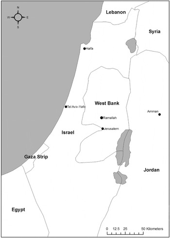


Urbanization, particularly in terms of private housing construction, constitutes a mounting threat to cultural heritage sites in Palestine. At risk are not only archaeological sites, but traditional architecture and other locations of cultural heritage. The Ramallah governorate serves as a practical case study by which to examine how this process of urbanization affects the cultural heritage of the region, because of the increased rate of development the governorate has experienced over the past decade. Since the establishment of limited Palestinian administration of the West Bank and Gaza Strip through the Oslo Accords of 1993 and 1995, the population of the Ramallah governorate has rapidly increased and witnessed a corresponding construction boom because of the city of Ramallah's role as the de facto Palestinian administrative seat (Figure 1). The establishment of Palestinian National Authority's administrative/political institutions and international aid organizations in Ramallah spawned an economic boom that was coupled with the return of members of the American diaspora and the internal migration of West Bank Palestinians to the city. Consequently, Ramallah has experienced a significant population increase that must be accommodated with a concomitant intensification of urban development, particularly in the area of housing construction.
Regional map.

The urbanization of Ramallah, as throughout the entirety of the Palestinian-controlled areas of the West Bank and Gaza Strip, has proceeded with relatively little governmental oversight and administration by the PNA. The result is a largely unregulated urban development that is typified by an absence of planning, which often places sites of cultural, historical, and archaeological significance in severe jeopardy. This article considers both the internal and external factors affecting the urbanization of Ramallah and proposes solutions to mitigate the dangers to cultural heritage posed by unchecked urban growth.
URBANIZATION AND CULTURAL HERITAGE PRESERVATION
Locations of cultural heritage—in the form of archaeological sites, monuments, historic buildings, and landscapes—are often at risk from social, political, legal, and economic forces that alter the long-term stability, viability, and protection of cultural properties. Often, these threats are bound within a context of premeditated violence—vandalism, looting, and destruction through warfare—and are roundly condemned as acts of cultural and historical ruination.Footnote 1 However, these same forces endanger cultural in a manner that receives considerably less attention within the archaeological discourse. Aspects of human development deemed positive and progressive—construction, cultivation, and expansion—equally threaten the longevity and security of cultural heritage, yet often fail to generate the same widespread condemnation. The formidable forces of unplanned development, incessant productivity, rampant innovation, and heedless technical advance can dramatically alter the artifactual and natural environment, which magnifies the scale of their destructive potential—whether the target is a rare species, a prehistoric site, or a historic building.Footnote 2
Indeed, urban restructuring and development actually involves a level of devastation, ruination, and forced resettlement that often matches that which occurs in all-out war.Footnote 3 Much like the process of archaeological excavation, urban development entails planned, purposeful destruction that alters the cityscape as well as the associated landscape, ethnoscape, and heritagescape. In urban environments with a deep history, development that is left largely unabated and unregulated poses a particularly troublesome dilemma for both the urban planner and the cultural heritage professional. Often, high concentrations of cultural heritage sites are situated in the areas of highest population density; a phenomenon that seemingly pits the desires of modernity, innovation, and progress in contradiction to the desires of historical preservation and protection.
Left unchecked, intense urban development without consideration of archaeological and cultural heritage preservation can result in instances of urbicide, where both the built environment itself and the specific existential quality embodied within the built environment are destroyed.Footnote 4 For many urban centers of the Middle East, archaeological and cultural heritage sites constitute a fundamental element of their existential quality; and, as such, their preservation and protection must factor into decisions regarding urban restructuring and development. However, despite the significance of cultural heritage in forging and maintaining modern identities, there is always the risk of hyperbole when discussing the crimes of archaeological and cultural heritage destruction. The loss of cultural heritage can affect multiple generations by permanently erasing their cultural memories and severing established links with the past. Yet it is dangerous to couch these acts in a language reserved for the destruction of human life, such as genocide, because they do not inhabit the same order of existence.Footnote 5 A balanced approach to cultural heritage and urban development recognizes the detriment of heritage destruction, while acknowledging that societies, particularly in urban environments, are bound to expand and develop in such a manner that threatens cultural heritage. To minimize the inescapable effects of urbanization to locations of cultural, historical, and national significance, cultural heritage considerations, particularly archaeological concerns, must be better integrated into general urban development and restructuring as well as specific, individual construction projects.
URBAN DEVELOPMENT IN PALESTINE
Historically, the development of Palestinian urban areas has been characterized by localism and similarity of purpose with each city functioning as an administrative and commercial center for its district.Footnote 6 The major urban areas of Palestine—Hebron, Bethlehem, Jerusalem, Jericho, Ramallah, Nablus, Qalqiliya, Tulkarm, and Jenin—all developed to their present size and stature because of their position as the administrative, economic, religious, and cultural centers of their respective hinterlands. Prior to the establishment of the British Mandate, urban planning authorities in Palestine resided almost entirely within the local municipal councils. The introduction of British rule in 1917 marks a fundamental transformation of urban planning in Palestine. No longer were local municipal councils empowered to make decisions regarding urban development; rather, the British enacted the first Palestinian Town Planning Ordinance in 1921, based off the 1909 English Town Planning Act, as a means of “social control.”Footnote 7 During the 1949 to 1967 Jordanian rule of the West Bank, urban planning decisions effectively reverted back to the local municipal councils; however, the introduction of the Israeli occupation in 1967 would again wrest control over urban development away from local jurisdictions. From 1967 until 1993, municipal and village committees were rendered effectively powerless in planning decisions because Israeli military authorities, under Military Order 418, established the Higher Planning Committee, which maintained complete control over land use policies and planning in the West Bank.Footnote 8 Throughout the Israeli civil administration, urban planning was accomplished through a nonobjective master plan that systematically disregarded the needs of Palestinian residents and resulted in urban development that was, at times, spontaneous, random, and inconsiderate of the environmental and cultural heritage ramifications of construction.Footnote 9
With the conclusion of the Oslo Accords in 1993 and the advent of limited Palestinian sovereignty, a new era of urban development was ushered into Palestine. Although the Oslo Accords enabled the fledgling Palestinian Authority to assert only a limited degree of sovereignty, it did provide for Palestinian control over development and planning in the largest urban centers: initially, Gaza City and Jericho and later Nablus, Ramallah, Bethlehem, Jenin, Qalqilia, and Tulkarm. The failure of fully implementing the Oslo Accords created a static situation where temporary division of the West Bank into different zones of Israeli and Palestinian security and civil control became entrenched realities on the ground. The result is that West Bank remains divided the same three cantons it did at the conclusion of the Oslo negotiations in 1993 (Table 1). Therefore, rather than exerting sovereignty over the entirety of the West Bank, which was the goal of the Oslo process, the Palestinian Authority has the ability to enact urban planning decision only in Area A and marginally in Area B.
Olso I Civil and Security Zones, 2003Footnote 10

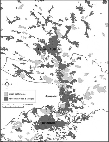
Although the political negotiations may have stalled, urban development in the Palestinian-controlled areas rapidly accelerated. The removal of restrictive Israeli land control policies in Area A resulted in dramatically elevated levels of construction, development, and alteration in the major Palestinian cities. With the establishment of Palestinian semiautonomy in Area A, modern concrete high-rise buildings began to dot the skylines of Palestinian cities and change the traditional local architectural character and style of the urban environment. The rapid urbanization of Palestinian cities initially threatened only the urban cores; however, the need for more and more buildings eventually caused developers to look toward the periphery and open hinterlands of the cities as potential locations for expansion.Footnote 11 With Palestinian development in the West Bank effectively limited to the 18.2% of the total West Bank land that is included in Area A, the strain of residential and commercial construction will become increasingly acute as the Palestinian population continues to grow. This trend can be seen in the number of illegal Israeli settlement and Palestinian cities and villages located along the Ramallah-Jerusalem-Bethlehem axis (Figure 2).
Urban development in the Ramallah-Bethlehem corridor.

According to 2006 United Nations projections, the Palestinian population has experienced a dramatic increase from slightly more than 1 million in 1950 to 3.8 million in 2005 and will have a projected population of 10.3 million by 2050. Furthermore, the 2006 United Nations projections trace the rise in the portion of the Palestinian population located within urban environments from 37.3% in 1950 to 71.6% in 2005 and is projected to reach 83% by 2050.Footnote 12 The advent of a rapidly increasing population settling into urban environments has, and will continue to, place tremendous pressures on the urban centers throughout Palestine and offer challenges to the urban planners responsible for their development. Compounding these demographic factors of increased urbanization and rapid population growth are the political problems of the ongoing Israeli occupation, the absence of full Palestinian sovereignty throughout the West Bank and the lack of proper institutional and legal infrastructure, all of which promotes rabid urbanization that endangers the environmental, archaeological, and cultural landscapes of the region. Perhaps nowhere in the West Bank are these crosscutting factors more prominent than in the Ramallah governorate.
CASE STUDY: RAMALLAH GOVERNORATE
Throughout history, the Ramallah governorate has served as an important economic, commercial, and strategic crossroad for the region; and, resultantly, it has a wide and diverse assemblage of archaeological and cultural heritage sites that date from the Paleolithic Era (1.5 million to 18,000 bc) to the Ottoman Era. These include archaeological sites from numerous prehistoric and historic eras; traditional buildings of various styles; and agricultural structures such as wells, presses, cisterns, and terraces. Within the city of Ramallah itself, human occupation dates to the Crusader era when a small military encampment was established by and subsequently abandoned as Crusader authority in Palestine waned. After abandonment by the Crusaders, Ramallah remained a small agrarian community with a predominantly Christian character that would slowly develop into an urban center. By the end of the nineteenth century, the stature of Ramallah had dramatically increased: In 1902 Ramallah was declared an administrative center for the region and in 1910 the Ottoman Empire established the Ramallah municipality.Footnote 13
With the political turmoil that plagued the region starting in the 1930s, Ramallah experienced a significant shift in population. Many residents with long family lineages established in Ramallah sought refuge from the strife by emigrating, often to North America.Footnote 14 The loss of these residents was offset by the influx of Palestinian families fleeing from the coast and plains towns (e.g., Jaffa, Lydda, Ramleh) during the 1948 war. Ramallah's population continued to steadily grow throughout the early years of the Israeli occupation. However, with the establishment of limited Palestinian administration of the West Bank and Gaza Strip through the Oslo Accords of 1993 and 1995, Ramallah experienced a more rapid population increase and corresponding construction boom because of the city's de facto role as the Palestinian administrative seat. The establishment of PNA's administrative/political institutions and international aid organizations in Ramallah spawned an economic boom that was coupled with the return of members of the American Diaspora and the internal migration of West Bank Palestinians to the city.Footnote 15
Presently, the Ramallah governorate covers 855 km2 and, based on a 2007 census, has a population of more than 290,000 that is distributed across 80 residential communities of various form and size.Footnote 16 The villages, towns, cities, and refugee camps of the Ramallah governorate account for 11.3% of the total number of communities in the West Bank and Gaza Strip.Footnote 17 Within the governorate, the sister cities of Ramallah and Al-Bireh effectively form a singular metropolitan area that is epicenter of urbanization in the West Bank. The 2007 Palestinian Central Bureau of Statistics census also revealed that nearly 93,000 (or 32% of the total governorate population) reside in Ramallah Al-Bireh, the neighboring community of Al-Tira, and the adjacent refugee camps of Al-Amari and Qaddura.Footnote 18 These population pressures often compel developers and entrepreneurs to provide more residential housing and commercial space to meet the demands of a rapidly increasing population in the city and its immediate hinterlands. However, like throughout the Palestinian-controlled areas of the West Bank and Gaza Strip, the urbanization of the Ramallah governorate has proceeded with relatively little governmental oversight and administration by the PNA. A chief consequence of this unregulated urban development is that locations of cultural, historical, and archaeological significance are often in severe jeopardy for the sake of residential and commercial construction.
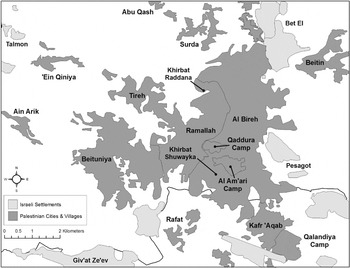
Although the Ramallah governorate covers a relatively small area—15% of the total West Bank—it has an incredibly rich assemblage of cultural heritage properties. This corpus of properties in the Ramallah governorate consists of more than 7500 historic buildingsFootnote 19 and 347 known archaeological sites and features, including the prominent archaeological sites of Shuqba Cave, Tell et-Tel (Ai), and Tell en-Nasbah.Footnote 20 The density of archaeological and cultural heritage sites poses the promise of economic prosperity for the Ramallah governorate, particularly in terms of tourism development; however, they also present serious preservation, protection, and management difficulties in light of the rapid and largely unregulated urban development at work in the governorate. Although the PNA has publicly recognized the threats facing cultural heritage properties throughout Palestine, the Palestinian Legislative Council (PLC) has only recently enacted laws to protect historic buildings and has yet to pass an antiquities protection law.Footnote 21 The sites of Khirbat Shuwayka, Khirbat Raddana, Khirbet el-Tirah and Ain Arik will serve as specific case studies to demonstrate how the lack of regulation and enforcement coupled with rapid urbanization jeopardizes the archaeological and cultural heritage of the Ramallah governorate (Figure 3).
Urban development in the greater Ramallah Al-Bireh metropolitan area.

Khirbat Shuwayka
The site of Khirbat Shuwayka, located to the south of modern-day Ramallah Al-Bireh along the historic Nablus to Jerusalem road, was first surveyed by Conder and colleagues in the 1880s, by Bagatti in the 1950s, and then by Israeli Staff Officer for Archaeology Yitzhak Magen in the 1980s.Footnote 22 The Institute of Archaeology at Al-Quds University has conducted nine seasons of excavation at the site between 1996 and 2006. These excavations have exposed many archaeological features and stratified layers, revealing a fortification system, residential complexes, a church, and a wine processing installation.Footnote 23
The residential complexes at Khirbat Shuwayka are composed of rectangular or squared rooms divided by thick walls with entrances. Archaeological evidence—particularly ceramic sherds—dates the use of these residential complexes from the Byzantine era through the Abbasid era. The church is a three-aisled basilica with a chapel located on its northern side. Archaeological data indicates that the church has three distinct phases of construction and renovation: two initial phases of construction in the Byzantine period (ad 324–638) and a later phase of reuse and rehabilitation in the early Islamic period (ad 638–1099). Along the eastern slope of Khirbat Shuwayka is a Byzantine era wine press consisting of a series of chambers and channels that facilitated a sizeable wine producing industry. Like the church and residential complexes, the wine press facilities indicate two distinct phases of use, with modifications and technological advances incorporated into the second phase. A fortification wall that encircles the site was constructed during the Byzantine and early Islamic periods. The remains of the walls, measuring up to 2.5 m in height, reveal that they were constructed of different sized stones and mud in irregular horizontal courses.
Historically, the area surrounding Khirbat Shuwayka was agricultural land; a trend that persisted from the Byzantine period through the late twentieth century. However, the 1970s would mark a transition in the region as urban sprawl from Ramallah city would begin to slowly alter the landscape. Initially, the construction of modern residential and commercial structures by local residents was limited to the Umm esh-Sharayet basin, but within a few short years private investors from outside the area would accelerate the pace of development in the region. As the city of Ramallah has rapidly expanded since 1995, Khirbat Shuwayka has become virtually encircled by the construction of new buildings that are increasingly encroaching on the boundaries of the archeological site. The increased construction in the Umm esh-Sharayet basin has been welcomed as an economic boon by the municipal council; however, development poses a significant risk not only to the archaeological site but to traditional buildings and the environment as well.
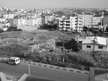
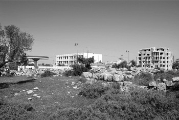
In February 2007, an impact assessment in the vicinity of Khirbat Shuwayka was initiated by al-Houdalieh. This assessment surveyed the development of residential and commercial buildings within a 250 m radius of Khirbat Shuwayka's centroid and identified 20 structures either completed or under construction. Furthermore, four sizeable parcels have been cleared and prepared for future construction. From a site preservation perspective, the most threatening development at Khirbat Shuwayka is a 160-m2 residential compound located near the crest of the Khirbat Shuwayka (Figure 4). The danger of this new housing construction is that it sits a mere 50 cm from the walls of the fortification system and approximately 2 m from an unearthed Byzantine/Early Islamic residential complex. The construction of the modern residential unit began in 2004 when an area of 1000 m2 was cleared with bulldozers and deep trenches were cut for the cement foundation. As a result, the land was excavated to a depth of 1.5 m without an archaeological impact assessment conducted by Al-Quds University or the Palestinian Department of Antiquities and Cultural Heritage (DACH). The protection of Khirbat Shuwayka from this construction was further complicated by the fact that the building was financed by the Fatah political party and is used for its social and political gatherings in the Umm esh-Sharayet region. Despite the potential political friction, DACH filed a civil case against the building owners in 2004 and demanded that the structure be removed from the premises. A 2005 ruling by a Palestinian court sided with the DACH and an order was issued for the structure's removal. However, because of the political fragmentation within Palestine and given the inability of the Palestinian executive to enforce legislative and judicial decisions, the building has not been removed.
View of Khirbat Shywayka with the Fatah-related building on the right and new residential constructions in the background.

It is impossible to reconstruct the exact extent of the damage done to Khirbat Shuwayka by this clearing and subsequent construction. Moreover, the materials accumulated through the clearing process were initially amassed along the edge of the construction site; however, as the building process began, these materials were reused as backfill to stabilize the residential complex. Any archaeological evidence contained within these soils is now completely decontextualized, rendering them entirely useless in any archaeological reconstruction of Khirbat Shuwayka's history. Several other structures that threaten the integrity of Khirbat Shuwayka were surveyed by an Al-Quds University team in 2003. As with the previous structure at Khirbat Shuwayka, the ongoing construction process for these structures began with clearing and grading the land; however, the construction area was bulldozed to the bedrock in many areas. Again, these structures were built without an archaeological impact assessment to determine what, if any, effects the construction process would have on the archaeological site.
Based on the 2003 Al-Quds survey and subsequent monitoring visits to the site, the overall effect of these buildings to Khirbat Shuwayka has proven to be substantial both in scope and magnitude. Specifically, the following encroachments on the site of Khirbat Shuwayka were observed during the Al-Quds surveys:
• Two concrete residential structures have threatened the stability and integrity of the Byzantine fortification walls located to their immediate south.
• A cement fence for a residential structure has been partially built atop the exposed remains of the fortification wall.
• Another residential structure infringes on exposed sections of the Byzantine wine processing facilities. Based on extrapolations of the archaeological data, it is probable that the wine processing facilities extend beneath the new construction.
• A series of residential buildings were built atop or immediately adjacent to Roman-Byzantine tombs. The occupants of these buildings have begun to use the rock-hewn tombs as a dumping ground for their household refuse.
• Parcels of land were bulldozed down to the bedrock in preparation for future construction in the area.
Approximately 3000 m2 of land surrounding Khirbat Shuwayka have been bulldozed, often to the bedrock. Examinations of the balks created by the clearing process indicated that the construction has indeed damaged archaeological remains outside of the Khirbat Shuwayka fortification walls. In the eastern section, the balks reveal traces of walls, surfaces, and column bases. Similarly, along the western section, two plaster-lined wine processing vats were located within the exposed balks.
Khirbat Raddana
Located atop a hill on the northern side of Ramallah, the archaeological site of Khirbat Raddana was excavated throughout the late 1960s and early 1970s by Callaway and Cooley.Footnote 24 Although the archaeological evidence indicates that Khirbat Raddana was occupied from the Early Bronze Age through the Byzantine era, the excavations of Callaway and Cooley helped to clarified the Iron Age I (1200–1100 bc) occupation of the site, particularly regarding residential architecture and domestic activities.Footnote 25 The hinterlands of Khirbat Raddana have been used for agricultural production since the Early Bronze Age through modern times; and as a result, cultivators throughout the ages have engaged in a constant effort of building, expanding, and repairing stone terraces in these fields to combat soil erosion. However, because of the encroachment of modern construction in Ramallah, the southern and eastern sections Khirbat Raddana and its system of terraces are at risk of being damaged or destroyed.
As the housing demand in Ramallah has increased, residential and commercial buildings have been built within close proximity of Khirbat Raddana. During the process of construction, bulldozers were used to excavate foundations and grade the land for the new homes and businesses. Unfortunately, this was often done without archaeological impact assessments. The commercial construction along the eastern edge of Khirbat Raddana posed the most severe threat to the site, resulting in approximately 1000 m2 of Khirbat Raddana being damaged by construction. A contemporary business building located along the eastern edge of the site threatens to cause further devastation to the site in the near future. Although the building has only moderately affected Khirbat Raddana, during the construction process the workmen used the site as a staging ground for construction materials and a dumping ground for debris and waste, including several piles of hardened cement that now litter the site and obscure the view of the site from the east. Furthermore, the location of this building invites further construction and development that will increasingly jeopardize the integrity of the site.
Khirbat el-Tireh
Approximately 1.5 km to the west of the Old City of Ramallah is the site of Khirbat el-Tireh. Field surveys conducted in the 1990s by Finkelstein and LedermanFootnote 26 indicated that the site was inhabited throughout the Hellenistic, Roman, Byzantine, and Ottoman eras. The architectural remains of Khirbat el-Tireh include a rock-cut olive press, a rock-cut cistern, a Byzantine era church, several burial caves and a fortification system presently made up of several wall sections of differing heights scattered across the site. Khirbat el-Tireh has suffered from the development of residential and commercial properties along its perimeter since the conclusion of the British Mandate. The Ramallah Women Training Centre, a United Nations Relief and Works Agency facility, was built along the southern and eastern edge of Khirbat el-Tireh in 1962. This construction resulted in severe damage to the site, specifically the fortification walls and smaller archaeological features located in close proximity to the site. Along the southern boundary, a modern cement wall was constructed atop a section of the fortification walls. In addition, cement was applied to sections of the fortification walls to reinforce and stabilize the modern cement wall, which further damaged the original fortification wall. Finally, in the area adjacent to this cement wall a thick layer of red soil has been applied and different species of trees have been planted. This has effectively encased portions of the site, which may now suffer damage caused by the intrusion of the trees' roots systems.
Along the north-eastern side of Khirbat el-Tireh, the St. George School was constructed in 1999 (Figure 5). The DACH initially excavated several test pits in an isolated corner of the site to determine the potential threat the construction posed to Khirbat el-Tireh; however, without further archaeological investigation, the site was bulldozed down to bedrock. It is likely that this resulted in the destruction of a long section of fortification wall and, quite possibly, associated archaeological objects and features. In addition, residential buildings have been constructed along the north, east and west of the St. George School, further encroaching on Khirbat el-Tireh and its immediate hinterlands. The building posing the greatest threat to the site is a modern residential compound built along the western fortification walls of Khirbat el-Tireh. This building was constructed in 2006 and 2007 on a parcel of 600 m2, which were bulldozed down to bedrock prior to construction. As with the St. George School, this residential compound damaged the fortification walls and likely destroyed all associated artifacts and features located nearby. More recently, crews have commenced construction of a gas station just to the west of the St. George's School. The landowner received a permit from DACH, which provided him legal license to start construction; however, the permit also specified that he avoid damaging the Byzantine reservoir pool located just 2 m from the new building antiquities located on the site. Immediately after receiving his permit, the landowner bulldozed the plot to 5 m below the bedrock, which instantly destroyed all the cultural deposits located within the bounds of the construction site.
View of Khirbat el-Tira with a new residential building on the right, St. George's School in the center, and gas station on the left.

Ain Arik
Located approximately 7 km west of Ramallah city, the village of Ain Arik covers 6000 dunums of hilltops and has a population of more than 1700.Footnote 27 Settlement of the modern village dates back to the Crusader era (ad 1099–1187) and, because of its position as an historical secondary crossroads connecting Haifa and Jerusalem, it has been continuously occupied to the present. As of 1922 the population of the village numbered 365 residentsFootnote 28; however, after the Nakbah of 1948, the population steadily increased to its current number. The historical and cultural richness of Ain Arik is evident in the historical sites surrounding the village, such as Khirbet el-Hafi, Khirbet Robin; Khirbet Kafr Sheiyan and Loza; and the numerous churches, shrines, burial caves, and winepresses situated within the village and its adjacent hinterland.
Many traditional buildings in Ain Arik, typically one-level structures with internal divisions, were constructed between the eighteenth century and the first quarter of the twentieth century; however, a few buildings have been dated to the thirteenth to sixteenth centuries. A 1997 field survey conducted by Riwaq indicated that the village includes 132 traditional buildings, of which 111 (84%) were assessed to be in satisfactory structural condition, and nearly 54% percent of these traditional buildings were still in use by the community.Footnote 29 In the subsequent decade, many traditional buildings in Ain Arik have fallen into disrepair and a significant number were in a state of abandonment. Based on a field survey conducted by al-Houdalieh in April 2007, approximately 70% of the traditional buildings are now abandoned; an increase of 16% in 10 years.
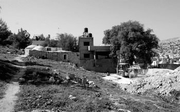
By the end of the British mandate, the built environment of Ain Arik covered about 13 dunums. Urbanization in Ain Arik began in 1950s as housing and commercial demands increased because of the improved economic conditions and the establishment of a refugee camp in 1948. Initially, this wave of development was centered in the village core where new residential structures and a few commercial buildings were constructed, effectively leaving the abandoned historic structures intact. However, over the next few decades, the historic structures of Ain Arik suffered from deterioration and damage, principally because of neglect. By the mid 1970s, the development of Ain Arik shifted from the periphery to the village center and posed a serious threat to the historic structures located in the core. The continued population increases in the village and the refugee camp, coupled with the absence of a codified master plan for land development, dramatically affected the historic structures of Ain Arik. The advent of modern construction in the village center resulted in the razing of numerous traditional buildings, rock-cut caves, cemeteries, olive presses, wine presses, and agricultural terraces. Starting in the middle of the 1970s, the unfettered development of Ain Arik has constantly threatened the heritagescape of the village. By 1988 more than 30 dunums of the village were developed with residential and commercial structures, and by 1997 this had increased to more than 150 dunums.Footnote 30 This process of unplanned urbanization over the past three decades has dramatically altered the historic character of the village and resulted in the complete destruction of 31 traditional buildings without any documentation or mitigation by the Palestinian Department of Antiquities and Cultural Heritage. During a March 2008 inspection of the site by the authors, a new construction project for a private residence was causing extensive damage to the local Muslim cemetery and nearby maqam (Figure 6).
New residential construction at Ain Arik with Muslim cemetery in the foreground and maqam in the background.

Conclusions
Throughout the Ramallah governorate, the rapid urbanization and unfettered new construction projects are endangering cultural heritage sites within the Ramallah Al-Bireh metropolitan area as well as the surrounding villages, which will ultimately become absorbed within the ever-encroaching urban sprawl. From a cultural heritage perspective, the combination of urban expansion and new construction projects is effectively guaranteeing the destruction of the archaeological, cultural, and historical record of the governorate, particularly in the traditional urban centers. This is the point where the theoretical discussion of urbicide and its effect on the existential quality bound within the built environment becomes reality; a reality is more severe with each newly constructed building. The current construction techniques used by Palestinian developers, specifically the bulldozing of land down to bedrock without any archaeological impact assessment, ensures the building process as a destructive act perpetrated against the heritage of the land. Although destruction is an unavoidable consequence of all archaeological research, the destruction involved with construction that fails to rigorously examine or properly preserve cultural heritage elevates the process to the level of urbicide.
Across the Ramallah governorate, there are several common underlying factors that contribute to the deteriorating condition of cultural heritage sites. Abandonment of historic structures in favor of modern, newly constructed buildings has resulted in a widespread use of these historic structures as local dumping grounds. The continued, long-term economic instability throughout Palestine prohibits many landowners from investing financial resources in the maintenance and upkeep of historic properties. Because historic structures prevent vertical development, real estate developers often view them as obstacles to eliminate. These factors are compounded by the rapid population increase in the Ramallah governorate; a general lack of awareness about the value and importance of cultural heritage in Palestinian society; and the inability of the Palestinian government, academic, and cultural heritage professionals to agree upon and enact policies, procedures, and programs that adequately safeguard the cultural heritage of Palestine.
To remedy these risk factors, the authors propose the following series of reforms intended to increase the preservation and protection of cultural heritage in Palestine while enabling urban development to continue in a reasonable and planned manner. The specific policy recommendations advocated by the authors are centered on the areas of oversight, legislation/enforcement, education, and coordination.
IMPROVING OVERSIGHT
Since the signing of the Oslo II accords in 1995, the legal responsibility for the protection, preservation, and promotion of cultural heritage in Palestine has resided with DACH. However, the persistent civil and military occupation of Palestinian territories by the Israeli military has effectively diminished the capability of this department to execute its legal obligations to protect and manage Palestinian cultural heritage resources. The restrictions on free movement imposed on West Bank Palestinians by the Israeli military (such as the Separation Wall, permanent checkpoint, flying checkpoints, unmanned roadblocks, closed military zones, closures, and curfews) has severely restricted the ability of Palestinian DACH officials to carry out their cultural heritage preservation and protection duties. This problem is exacerbated by the financial difficulties of the Palestinian National Authority, which limits the number of DACH employees. At present, DACH employs approximately 295 Palestinians in its various offices in the West Bank and Gaza Strip; this number of employees has not significantly increased since 1995. With a limited budget and staff, it has been nearly impossible for the DACH to contend with the rapid rate of urbanization and widespread looting that threatens cultural heritage sites throughout Palestine. Despite the obstacles facing DACH, however, an improved regime of site monitoring and impact assessment is necessary.
Although it is undoubtedly difficult for DACH employees to monitor every site located within the entirety of Areas A & B of the West Bank, numerous sites within the Ramallah Al-Bireh metropolitan area—where the DACH is headquartered—have suffered from inadequate preservation and protection. Furthermore, it is here, within the confines of the Ramallah Al-Bireh vicinity, that our case studies have demonstrated the ineffective protections afforded archaeological and cultural heritage sites threatened by commercial and residential construction projects. To mitigate the threat, the authors propose a systematic monitoring regime to be initially implemented in the Ramallah Al-Bireh metropolitan area and subsequently expanded throughout Area A and later to Area B. This monitoring regime would be conducted by DACH employees based in the department's Ramallah headquarters and would involve monthly inspections of the major archaeological sites in the region to ensure site integrity and site visits to newly approved commercial and residential construction projects to assess the archaeological effect. By instituting such a program of monitoring and assessment, DACH could guarantee the minimal preservation and protection of cultural heritage sites from the onslaught of unregulated urban development.
ENACTING LEGISLATION
To date, the PLC has only generated draft legislation for the protection of natural, cultural, and archaeological heritage in Palestine. The PLC draft legislation for heritage management is currently in its fourth iteration; and therefore the applicable law for the protection of cultural heritage in Palestine is the 1929 Law of Palestinian Archaeology (Antiquities Ordinance),Footnote 31 which was enacted by the British high commissioner in Palestine and defines protected antiquities as objects predating ad 1700. Although this law has been modified and expanded during both the Jordanian and Israeli occupations, it remains the principle legal framework for cultural heritage preservation in Palestine. Thus many archaeological and cultural properties that may have significance or value to local communities are left without defined legal protection.
A 2006 assessment of the Palestinian cultural heritage sector conducted by the Swedish International Development Cooperation Agency affirmed that the major challenges facing heritage management in Palestine were outdated laws and particular classes of cultural property that were neglected by previous laws.Footnote 32 In response, the unofficial drafts of the proposed Palestinian cultural heritage legislation provide legal protection for cultural heritage property neglected in the various forms of the 1929 Antiquities Ordinance. In particular, the proposed legislation replaces the concept of antiquities and its associated definitions with a more broadly construed concept of cultural heritage that is defined as heritage objects greater than 50 years old. The immediate benefit from this redefinition of Palestinian cultural heritage is that objects and properties historically without legal safeguards would now be afforded full legal protections. Beyond the legislative revisions regarding the definitions of antiquities and the protections afforded to them, the PLC must act immediately to ratify the current iteration of the cultural heritage law. The potential shortcomings of the draft legislation would be minor in comparison to the added protections that the law would provide to cultural heritage sites. Furthermore, any necessary revisions that the law may require could be added through subsequent legislation; however, in the meantime the cultural heritage sites of Palestine, particularly those in the Ramallah governorate, would have more legal protection against the rapid urban development facing the Palestinian urban centers.
RAISING AWARENESS AND EDUCATION
A commonly recognized problem within the Palestinian cultural heritage management system is the lack of awareness within the Palestinian community concerning the dangers facing archaeological, historical, and cultural heritage.Footnote 33 Often these awareness campaigns focus on the communities living within the immediate vicinity of cultural heritage sites. By providing educational programs in the local schools and outreach programs geared toward local residents, Palestinian cultural heritage professionals have realized dramatically improved preservation and protection of the cultural heritage sites in these communities. When coupled with better cultural heritage legislation and law enforcement, public awareness activities serve as powerful tools to reinforce the protection of cultural heritage sites.Footnote 34 The authors strongly advocate for additional outreach programs designed to improve public awareness of culture heritage preservation and, in addition, recommend the implementation of education programs specifically targeting urban planners. Currently in Palestine, An-Najah National University and Birzeit University offer degrees in urban planning; however, neither program requires its students to take courses in cultural heritage preservation. Given the wealth of archaeological and historical sites located in the Palestinian urban centers and the predicted acceleration of development within these centers, the authors believe it is imperative that urban planning programs in these institutions require their students to take a course in urban heritage preservation.
ENHANCING COORDINATION
In this era of continued occupation and political instability, the preservation and protection of archaeological and cultural heritage in Palestine severely suffers. Yet despite the often crippling effect of Israeli military policies and internal Palestinian political struggles, the core components—executive agencies, trained scholars, legal protections—of a vibrant and effective historical preservation system exist within Palestine. Although the effectiveness of these components may be questionable, their capacity to effectively manage and protect the cultural heritage of Palestine from the destructive potential of unplanned urban development is not in doubt. The most serious obstacle to the realization of this potential within the Palestinian preservation community is internal tensions, fragmentation, and a general lack of coordination among the various stakeholders. The DACH, academic institutions, scholars and nongovernmental organizations have frequently preferred to work independently or in opposition to each other. This friction and infighting has resulted in further deterioration and destruction of cultural heritage sites and structures. To remedy this, Palestinian politicians, academics, cultural heritage professionals, and local communities must work together to generate a united, comprehensive plan for the immediate defense of cultural heritage in Palestine.
To facilitate the coordination of the various cultural heritage stakeholders and better engage developers and builders, the authors recommend the establishment of a national development and planning committee. The purpose of this national committee would be to fully represent the disparate interests of the government, cultural preservation specialists, scholars, developers, entrepreneurs, and local communities to ensure that the urban development necessary for the advancement of Palestinian society is undertaken in such a manner that cultural and historical sites are afforded adequate protection and preservation. Specifically, the national development and planning committee recommends urban planning policies for developers and entrepreneurs to ensure that cultural heritage sites and structures are protected during urban development projects.
Although this is an obviously difficult task to accomplish, models for successful navigation of the potential pitfalls involved in reconciling the often competing priorities of cultural heritage professional and urban developers can be found currently at work in Palestine. Both RIWAQ Centre for Architectural Conservation and the Hebron Rehabilitation Committee (HRC) have completed projects in the old cities of Ramallah, Bethlehem, and Hebron where historic building have been rehabilitated to serve the needs of a modern urban population.Footnote 35 By marrying both urban development and cultural heritage in their projects, RIWAQ and HRC have managed to effectively increase the residential and commercial capacity of the urban cores while simultaneously assuring the proper preservation of cultural heritage sites. Although the successes of RIWAQ and HRC are laudable, keep in mind that these projects are largely limited to development within the traditional urban cores of the cities or, in common parlance, the old cities. In an era of increased urban sprawl that threatens not only the tradition cores but also their hinterlands, preservation and rehabilitation programs must extend beyond the old city boundaries. Therefore, the successful processes and methods used by RIWAQ and HRC in the urban cores of Ramallah, Bethlehem, and Hebron should be used as a template on which the national urban planning policies are modeled to successfully bridge the often competing interests of cultural heritage management and land development.