

Çatalhöyük is often described as a Neolithic ‘megasite’ with a large, densely packed population that is puzzling because it predates by 3000 years the kind of urban settlement associated with early cities. Although no longer seen by most archaeologists as the ‘first city’ (e.g. Mellaart Reference Mellaart1967), Çatalhöyük is nevertheless still viewed as exceptional: a site whose size ‘pushes the idea of an egalitarian village to its ultimate extremes’ (Hodder Reference Hodder2006, 98), a huge street-less mass of houses that was a ‘“dead end” in the evolution of human architecture and settlement planning’ (Ben-Shlomo & Garfinkel Reference Ben-Shlomo and Garfinkel2009, 204). The megasite phenomenon in general remains a key problem in Near Eastern Neolithic archaeology, subject to inquiries about how megasites fit within settlement systems (Akkermans Reference Akkermans, Akkermans, Bernbeck, Nieuwenhuyse and Rogasch2013; Kuijt Reference Kuijt2000; Simmons Reference Simmons2007; Verhoeven Reference Verhoeven, Banning and Chazan2006), as well as a revived interest within some circles in megasites as precursors in the process of urbanization (Bogaard & Isaakidou Reference Bogaard, Isaakidou, Finlayson and Warren2010; Der & Issavi Reference Der and Issavi2017; Mazzucato Reference Mazzucato2016).
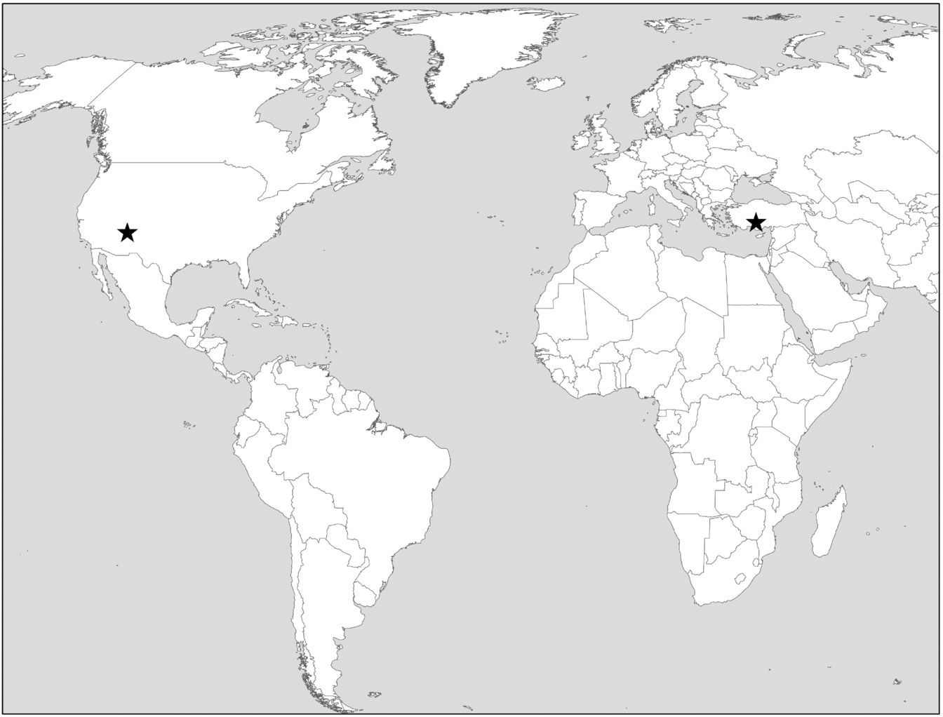
In this paper, we raise questions about exceptional claims regarding the size and social organization of Near Eastern megasites like Çatalhöyük by comparing them to pueblos in the American Southwest, in particular the pueblo of Awat'ovi (Fig. 1). Although comparisons between Çatalhöyük and pueblo architecture are not uncommon (e.g. Hodder Reference Hodder2006, 25), these are often anecdotal (but see Mills Reference Mills and Hodder2014). Here we suggest that more systematic comparison can provide insights into key questions about Çatalhöyük population levels and social organization, and about the phenomenon of Near Eastern Neolithic megasites more generally. Awat'ovi has roughly the same architectural footprint as Çatalhöyük, but is estimated to have had a population less than half the size, and is interpreted as a classic ‘tribal’ village rather than a proto-urban centre. We argue that four factors contribute to disparate interpretations of these structurally similar sites: 1) surface architectural visibility; 2) different regional intellectual traditions that emphasize ‘micro-’ versus ‘macro’ scale social organization; 3) a tendency toward overestimation in archaeological population estimates, especially when the ‘biggest’ or ‘earliest’ sites are involved; and 4) perceptions of continuity with later time periods.
Locations of Çatalhöyük and Awat'ovi.

Rather than outliers requiring special explanation, we argue that Çatalhöyük and other Near Eastern Neolithic megasites are better understood as large villages whose size, layout and social organization compare readily to many of the late prehispanic and historic pueblos in the American Southwest. While megasites were undoubtedly important social and demographic centres, we suggest that current population estimates exaggerate their uniqueness within ancient farming societies. While we still need to explain how and why some places experienced more aggregation than others, there is little need to trumpet Near Eastern Neolithic megasites as particularly unusual in terms of their size or social organization.
The case for comparison
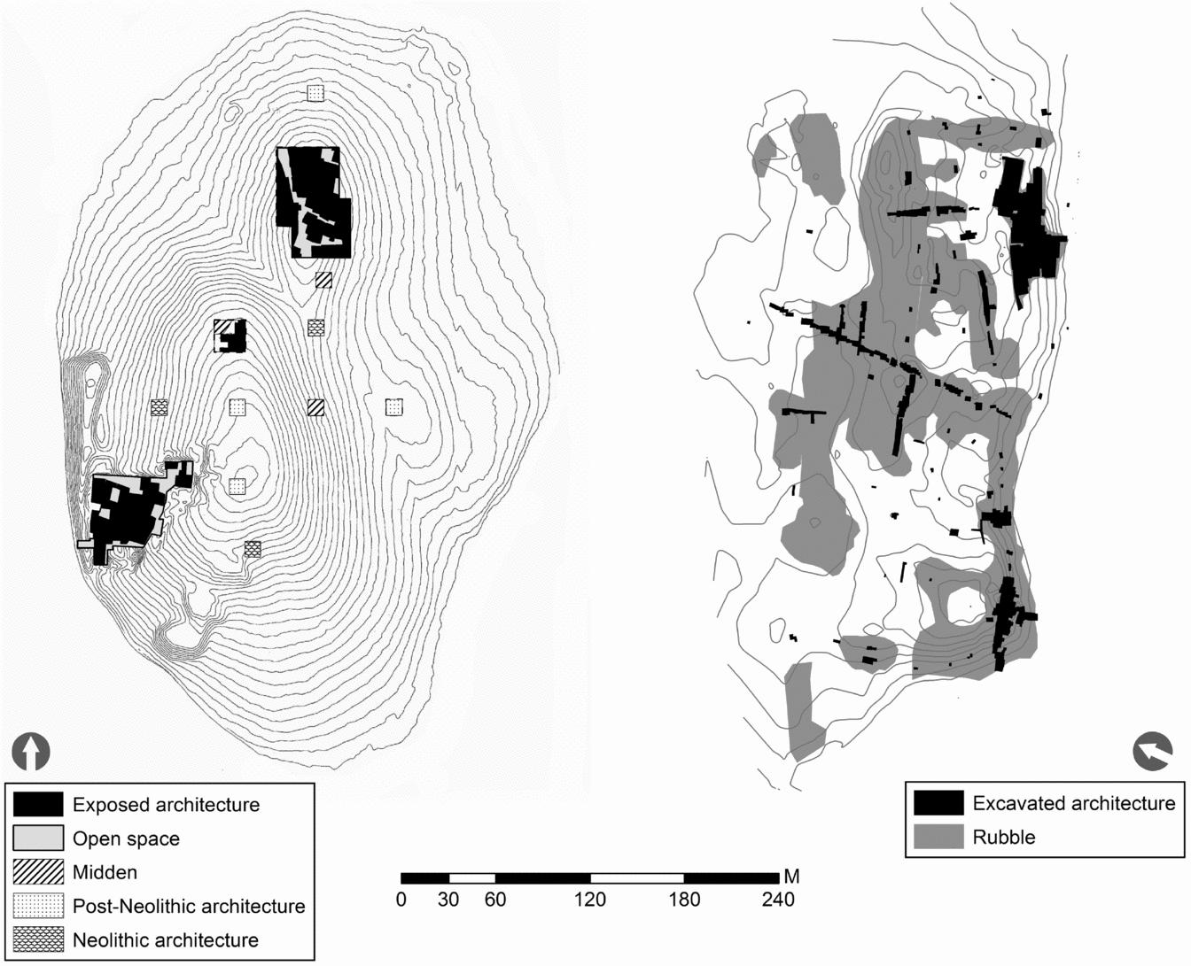
Çatalhöyük (Fig. 2a) is located in central Turkey and was occupied for more than 1000 years from c. 7100 to 6000 bc (Bayliss et al. Reference Bayliss, Brock, Farid, Hodder, Southon and Taylor2015; Hodder Reference Hodder2014). The site consists of two large mounds of stratified mud-brick architecture on either side of a small river; the eastern, larger mound dates to the Neolithic and is the focus of this study. The 13.5 ha eastern mound rises 17 m above the floodplain with at least two distinct peaks suggestive of different zones of occupation, though both peaks appear to date primarily to the Neolithic (Matthews Reference Matthews and Hodder1996). The site reached its maximum extent c. 6700–6500 bc, which roughly equates to the Çatalhöyük Research Project's South levels M, N, O and 4040 levels F and G, and to Mellaart's levels VIII–VI (Hodder Reference Hodder2014, 11). Recent work suggests that a significant transformation occurred c. 6500 bc, with changes in building size, layout and distribution. Most buildings appear to have had only a single storey (but see Hodder Reference Hodder2009), although roofs were likely commonly used for outdoor activity (Hodder Reference Hodder2006), just as they were in historic pueblo villages (Mindeleff Reference Mindeleff1891).
(a) Çatalhöyük Eastern mound showing excavated and open areas (redrawn after Düring Reference Düring2006, fig. 6.32; Reference Düring2007, fig. 6; Matthews Reference Matthews and Hodder1996, fig. 7.1, 7.5; and Hodder Reference Hodder2014, fig. 4. South area shows Mellaart's level VIB buildings, which are roughly but not precisely contemporary with North area and the smaller central area, which show architecture exposed by surface scraping. Smaller squares are also from surface scraping); b) Awat'ovi (map by authors, partly redrawn after Montgomery et al. Reference Montgomery, Smith and Brew1949, fig. 3, and Gilpin in press, fig. 6.01). 1 m contour interval in both maps.

Awat'ovi (Fig. 2b) is located in northeastern Arizona and was occupied for roughly 450 years c. ad 1250–1700 (Smith Reference Smith1971). The 10.6 ha site sits on the edge of a mesa overlooking a broad plain. The earliest occupation of Awat'ovi was in the Western Mound which grew to a four-storey pueblo of 1000 rooms or more, now visible as an irregular masonry rubble pile rising up to 8 m above bedrock. Beginning in the ad 1400s, occupation at Awat'ovi began to expand to the east, but occupation of the western and eastern sides of the site overlapped considerably. The site eventually comprised more than 4000 rooms, though by the late ad 1400s the Western Mound appears to have been largely vacated. A Spanish mission was built in the southeastern corner of the site in ad 1629, and the village was destroyed in ad 1700 by a coalition of Hopi villages (Montgomery et al. Reference Montgomery, Smith and Brew1949).Footnote 1
Both sites appear to lack a surrounding community of smaller settlements. Awat'ovi had a neighbour of comparable size 5 km to the northeast until c. ad 1500, after which the closest large village was 15 km to the northwest; a total of four large villages, one on each of four neighbouring mesas, constituted the Hopi cluster in the sixteenth and seventeenth centuries. A search for sites in the 1000 sq. km around Çatalhöyük confirms that the site was uniquely large for its time period and that nearby small sites largely pre-date it (Baird Reference Baird and Hodder2006). Çatalhöyük was apparently more isolated than Awat'ovi, separated from its closest known potentially contemporary village (Canhasan) by 60 km, and from the closest Neolithic megasite, Asikli Höyük, by 130 km.
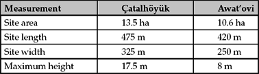
Çatalhöyük and Awat'ovi have roughly the same archaeological footprint (Table 1). Çatalhöyük covers a slightly larger area and has a taller mound, but these differences can be largely explained by three factors. First, Çatalhöyük was occupied two to three times longer than Awat'ovi. Second, the mud-brick architecture of Çatalhöyük is likely to generate a mound of residential debris more quickly than the masonry architecture of Awat'ovi, which can be more readily recycled as old buildings are replaced, decreasing its overall volume. The frequent rebuilding of rooms in the same place at Çatalhöyük (Düring Reference Düring2005) also contributed to the height of the tell. Third, the horizontal footprint of the sites may be expected to differ because multi-storey architecture was common at Awat'ovi, enabling greater packing of floor area into smaller horizontal spaces. The area of domestic space per residential unit is nevertheless comparable between the two sites: households at Çatalhöyük occupied 10– 40 sq. m (mean 27 sq. m), with main rooms that averaged 21 sq. m (Düring Reference Düring2007, 29); rooms in the western mound at Awat'ovi averaged 5.3 sq. m, and although rooftop doorways were not preserved we can infer household suites of 6–10 rooms that are well documented at nearby pre-contact and historic pueblos (e.g. Adams Reference Adams2002, 128; Dohm Reference Dohm1990) for a total household floor area of c. 30–50 sq. m. Accounting for these factors, the sites are good candidates for comparison.
Size comparison of Çatalhöyük and Awat'ovi.

Although we recognize problems inherent in comparison of archaeological sites and cultures across such vast distances of time and space, we also raise one further point to argue that these two sites are better matched than it may first appear. Recent work on the origins of agriculture and accompanying social and technological change in the Near East and Southwest North America suggests that these two sites occur at roughly similar points in time relative to the first appearance of cultigens, the transition from round to rectilinear architecture and the first use of pottery vessels for cooking (Table 2; see Kohler et al. Reference Kohler, Smith, Bogaard, Feinman, Peterson, Betzenhauser and Pailes2017). Both sites appear just over a thousand years after the first appearance of effective agriculture in their respective regions and a few hundred years after the transition to rectangular, agglomerated architecture. Pottery appears earlier relative to Awat'ovi's founding, although we note that the Southwest experienced a similarly long (2000-plus years) ‘Pre-pottery Neolithic’ characterized by small settlements, mixed foraging/farming subsistence economies and relatively high mobility (Roth Reference Roth2016). Although late prehispanic periods in the Southwest are not often considered relevant to discussion of agricultural origins, recent work has demonstrated that these periods display many of the hallmarks of the Neolithic Demographic Transition (Kohler & Reese Reference Kohler and Reese2014) and can rightly be considered an analogue to the similarly long process documented for the ancient Near East and elsewhere.
Timing of major archaeological transitions during the rise of agriculture in central Anatolia and the Tusayan region.

* Kohler and Reese (Reference Kohler and Reese2014) date the appearance of ‘effective agriculture’ in the Southwest to ad 500, 750 years before the founding of Awat'ovi.
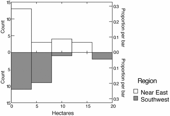
This paper focuses on Çatalhöyük and Awat'ovi as case studies, but they stand for a larger population of sites in their respective regions. Though it has received the most attention, especially among the public, Çatalhöyük is not the only Neolithic megasite (defined by Simmons (Reference Simmons2007) as more than 8 ha in size) in the Near East: sites of 10–15 ha such as Abu Hureyra, Domuztepe and Sha'ar Hagolan are known from Syria, eastern Turkey and Jordan (Düring Reference Düring and Birch2013; Kuijt Reference Kuijt2000; Verhoeven Reference Verhoeven, Banning and Chazan2006). And while Awat'ovi is one of the largest sites in the American Southwest, it had a number of peers in the proto-historic and historic periods. Figure 3 shows the sizes of 25 Neolithic sites from the south-central LevantFootnote 2 and 24 sites from the post-contact period American Southwest; the range of sizes is comparable, as is the maximum site size (neither Çatalhöyük nor Awat'ovi is included in the figure).
Site size (in hectares) of Neolithic sites in the south-central Levant and historic pueblos from the American Southwest. (Data from Kuijt Reference Kuijt2000, 81, table 1, and Dohm Reference Dohm1990, 211, table 3.)

The implications of size
Despite their similar architectural footprints, reconstructions of population for Çatalhöyük and Awat'ovi differ dramatically. Cessford's (Reference Cessford and Hodder2005) estimates represent the most rigorous attempt to model population at Çatalhöyük. He first estimated the number of collapsed structures per occupation level contained in the volume of the mound, taking into account the life-span of buildings and the number of levels of occupation and allowing for 20– 30 per cent unoccupied space and 10–15 per cent unoccupied buildings, for a momentary total of 408–1845 buildings. Assuming that each building occupied 40 sq. m, he then applied a number of per capita area constants from Naroll (Reference Naroll1962), Casselberry (Reference Casselberry1974) and Cook and Heizer (Reference Cook, Heizer and Chang1968) to derive momentary population estimates ranging from 1632 to 16,605, with a mid-range of 3458 to 7983 deemed most likely (Cessford Reference Cessford and Hodder2005, 325). The mid-range population numbers fit with other published estimates in the 5000–8000 range (e.g. Düring Reference Düring2006; Reference Düring2007; Hodder Reference Hodder, Bailey, Whittle and Cummings2005; Matthews Reference Matthews and Hodder1996).Footnote 3 The population of Abu Hureyra 2 in northern Syria, a comparably sized megasite at 11.5–16 ha, is also estimated at 5000–6000 for its peak using similar methods of estimation (Moore et al. Reference Moore, Hillman and Legge2000, 273–4). The population of the much smaller site of Tell Bouqras in eastern Syria (2.5 ha) is estimated at 700–1100 people, equivalent to 3780–5940 for a settlement the size of Çatalhöyük (Akkermans et al. Reference Akkermans, Fokkens, Waterbolk, Cauvin and Sanlaville1981); the 4 ha site of Asikli Höyük is similarly estimated at 1080–2700 people, equivalent to 4320–10,800 people for a settlement the size of Çatalhöyük (Düring Reference Düring2006, 101).
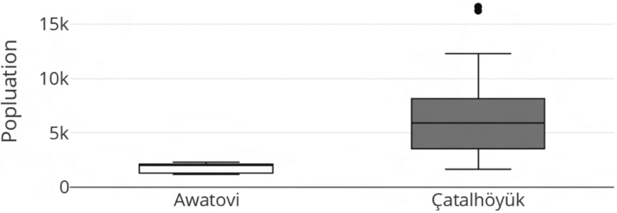
For Awat'ovi, Adams et al. (Reference Adams, Dongoske, LaMotta, Adams and Duff2004) list 4200 total rooms, of which they estimate that 1200 may have been occupied at any one time; applying a constant of 1.5 people per room commonly used in the American Southwest (Adler Reference Adler and Lipe1992) results in a total of 1800 people. For this study we produced population estimates for Awat'ovi following Cessford's (Reference Cessford and Hodder2005) method. The total number of rooms was estimated from the area of rubbleFootnote 4 (15,781 sq. m) and assumes an average room size of 5.3 sq. m, a value derived from a large excavated sample (James Reference James1994, table 6.1; Smith Reference Smith1971), yielding a total of 2977 ground-floor rooms. Note that the surface visibility of Awat'ovi allows open space to be calculated much more accurately than at Çatalhöyük (see below); 70–80 per cent of Awat'ovi's footprint consists of open space, as compared with Cessford's estimate of 20–30 per cent open space at Çatalhöyük. Room blocks were estimated to have one, two, or three stories based on rubble mound height, with constants for the proportion of upper-storey rooms applied following Kintigh (Reference Kintigh1985, 23), for a total room count of 3522. Following Cessford (Reference Cessford and Hodder2005, 324), 10–20 per cent of the structures were assumed to be abandoned but still standing. Rooms were apportioned into the two main occupations (ad 1300–1425 and ad 1425–1600) based on ceramic dates (Gilpin in press) and population estimates were calculated separately for each occupation. Using the same per capita area constants applied by Cessford (Reference Cessford and Hodder2005, 325–6) to total room areas, momentary population estimates range from 447–745 people for the early period and 739–1231 for the late period. Given that Cessford's population estimates for Çatalhöyük cover a period of 570–880 years, more than double the time modelled at Awat'ovi, we might assume that under Near Eastern dating conditions the early and late occupations at Awat'ovi could not be distinguished chronologically, producing total population estimates for Awat'ovi of 1186–1976. Thus, while population estimates for Çatalhöyük and Awat'ovi overlap, the ‘consensus values’ are substantially different and extreme values diverge considerably (Fig. 4).
Boxplot of population estimates for Çatalhöyük and Awat'ovi. (Çatalhöyük data from Cessford Reference Cessford and Hodder2005, table 16.2.)

A significant body of literature has developed around the idea that the form of governance in a human community is related to the number of people it contains (e.g. Alberti Reference Alberti2014; Bandy Reference Bandy2004; Bernardini Reference Bernardini1996; Carneiro Reference Carneiro and Donald1987; Dunbar Reference Dunbar2011; Fletcher Reference Fletcher1995; Johnson Reference Johnson, Redman, Berman, Curtin, Langhorne, Versaggi and Wanser1978; Reference Johnson, Renfrew, Rowlands and Segraves-Whallon1982; Ortman et al. Reference Ortman, Cabaniss, Sturm and Bettencourt2014). From this perspective, increasing community size produces decision-making stress which is resolved either through community fission, the development of suprahousehold groups, or the emergence of leadership hierarchies. Of particular relevance to this study is an apparent cross-cultural threshold of about 2500 people (±500) above which formal, hierarchical leadership is almost always present (Feinman Reference Feinman, Feinman and Marcus1998; Johnson Reference Johnson, Renfrew, Rowlands and Segraves-Whallon1982; Kosse Reference Kosse1990; Lekson Reference Lekson1985).
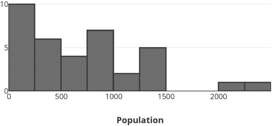
In this light, the different population estimates for Çatalhöyük and Awat'ovi take on new significance. The population of Awat'ovi is estimated to have been below the 2500-person threshold and thus presumably had non-hierarchical leadership; in fact, no Southwestern pueblo is estimated to have housed more than about 2500 people (Fig. 5). In contrast, the population of Çatalhöyük and other Near Eastern Neolithic megasites is estimated at well above the 2500-person threshold and presumably would have required a formal decision-making hierarchy.
Histogram of late prehistoric southwestern pueblo population size. (Data from Duwe et al. Reference Duwe, Eiselt, Darling, Walker and Willis2016, table 7, and Dohm Reference Dohm1990, 211, table 3.)

Çatalhöyük's first excavator explained its large size by labelling it as the ‘first city’ (Mellaart Reference Mellaart1967; see also Jacobs Reference Jacobs1969; Rosenburg Reference Rosenberg, Özdooan, Hauptmann and Baogelen2003). More recent research has questioned this interpretation, noting the limited evidence of economic specialization and lack of clear evidence of leaders or a hinterland of dependent settlements (Düring Reference Düring and Birch2013; Simmons Reference Simmons2007, 175–81), though the language of urbanism and cities lingers in other fields (e.g. Soja Reference Soja2000; see critique by Smith et al. Reference Smith, Ur and Feinman2014). Rather than a city, most contemporary archaeologists see Çatalhöyük as a massively overgrown village consisting of ‘nothing but houses’ (Hodder Reference Hodder, Bailey, Whittle and Cummings2005, 127; see also Der & Issavi Reference Der and Issavi2017, 196). But how could a settlement far above the 2500-person scalar threshold survive in the absence of more formal organization? Hodder (Reference Hodder, Bailey, Whittle and Cummings2005; Reference Hodder2006) initially classified the site as anomalous, a huge settlement seemingly held together by household ritual. More recently he has noted the importance of ‘history houses’ (Hodder & Pels Reference Hodder, Pels and Hodder2010) and non-kin-based sodalities (Hodder Reference Hodder2014) in integrating the hundreds of households present at the site. The latter idea derives at least in part from Barbara Mills’ (Reference Mills and Hodder2014) discussion of the utility of Pueblo ethnography on religious sodalities for understanding potential integrative mechanisms at Çatalhöyük.Footnote 5 Düring (Reference Düring and Birch2013) tries to resolve the scalar contradiction by arguing that Çatalhöyük was divided into 25–50 village-sized ‘neighbourhoods’ of 200–300 people, each of which functioned relatively autonomously. Thus, its inhabitants ‘did not suffer from scalar social stress, because they did not live in a single, large community. Instead, their social life was compartmentalized’ (Düring Reference Düring and Birch2013, 38; see also Kuijt Reference Kuijt2000). Ethnographic precedents for such densely packed, autonomous neighbourhoods, however, tend to be found only in state-level societies (e.g. Abu-Lughod Reference Abu-Lughod1987; Antoun Reference Antoun1972) where the presence of markets, laws, police and other institutions reduce horizontal dependency among co-residents, making them a poor analogue for Çatalhöyük.
We argue that the scalar contradiction of a large population without hierarchical organization at Çatalhöyük is more apparent than real. The problem lies in the population estimates themselves, not in the proposed mechanisms of social organization.
Method and interpretation in the American Southwest and the Near East
Why have archaeologists working in the Near East and American Southwest settled on such different population estimates for Çatalhöyük and Awat'ovi despite their similar areal sizes? Below we explore four potential factors that may be at work.
Surface visibility
Perhaps the biggest difference in architectural data recovery between the Near East and American Southwest is the visibility of architecture on the surface of sites. At most large Southwestern pueblos soil deposition is slow enough, and masonry wall foundations are stable enough, that rubble piles and wall alignments are often distinct 1000 years after site occupations. In contrast, architecture is rarely distinctly visible on the surface of Near East tells, requiring costly and time-intensive excavation that seldom exposes more than 5 per cent of a large site. Further, the stratigraphy of large tells can be quite complex, making it difficult to trace an occupation surface across the mound (see below).
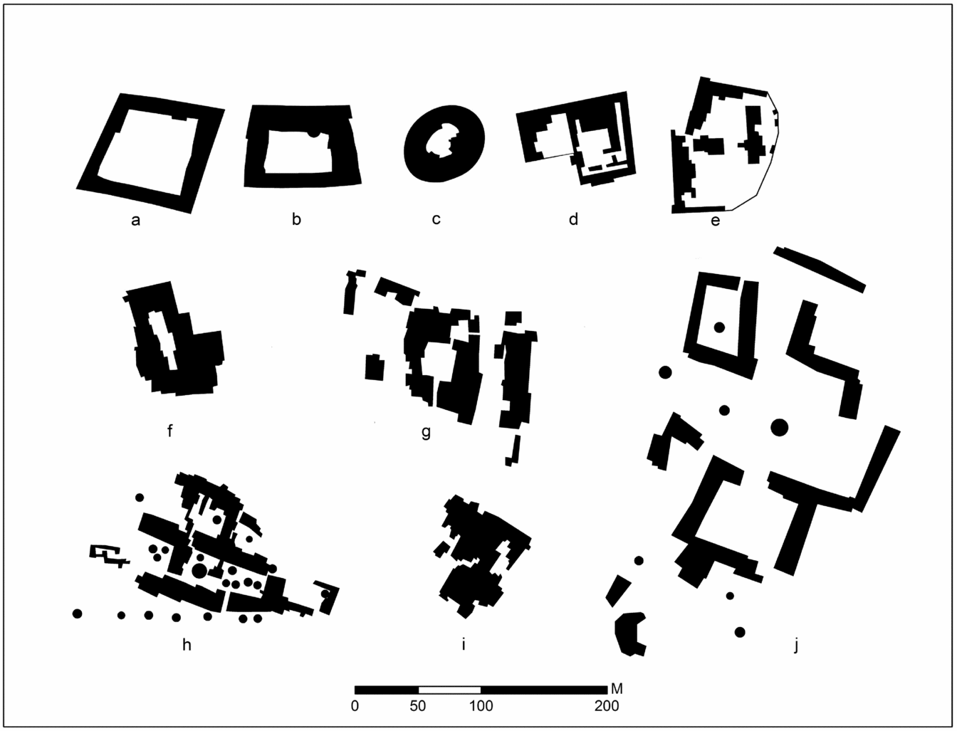
The excellent surface visibility of architecture in the American Southwest teaches an important lesson about the internal structure of large villages: while room blocks and open spaces are organized in variable configurations in different regions and time periods, rarely is the footprint of a large site filled with an unstructured mass of contemporaneous rooms (Fig. 6). Instead, blocks of rooms are arranged around open spaces that functioned as streets, plazas, courtyards, or settings for community structures. At Awat'ovi, 70–80 per cent of the site's area consists of open space; across the Southwest, large pueblos average 57 per cent open space (range 23–85 per cent, standard deviation 16.5) (Potter Reference Potter and Spielmann1998, table 8.2)—twice the typical assumption for Near Eastern tells. Construction of Southwestern villages could be pre-planned, resulting in formal arrangements of room blocks, or agglomerative, resulting in irregular arrangements; planned layouts tended to become more disordered over time as rooms were dismantled and reconstructed (e.g. Cameron Reference Cameron1999). It is also important to note that in ethnographically documented pueblos, open, ceremonial spaces (plazas) are not always formally bounded and may be difficult to differentiate from middens or other open spaces archaeologically.
Examples of large, late prehistoric southwestern pueblo layouts.(a) Pueblo de los Muertos; (b) Atsinna; (c) Lower Deracho Ruin; (d) Yellowhouse; (e) Los Pilares; (f) Bailey Ruin; (g) Grasshopper Pueblo; (h) Pecos Pueblo; (i) Turkey Creek; (j) Ponshipa'akedi'owingeh. (a–g redrawn after Peeples Reference Peeples2018, fig. 7.3; h redrawn after Kidder Reference Kidder1958, fig. 20; i redrawn after Lowell Reference Lowell1991, fig. 2.3; j redrawn after Duwe et al. Reference Duwe, Eiselt, Darling, Walker and Willis2016, fig. 5.)

How one interprets evidence for the nature and extent of open spaces at Çatalhöyük and other Near Eastern Neolithic megasites crucially affects population estimates (see Akkermans Reference Akkermans, Akkermans, Bernbeck, Nieuwenhuyse and Rogasch2013, 71–2; Verhoeven Reference Verhoeven, Banning and Chazan2006). Most estimates propose that nearly the entire maximum extent of megasites was occupied during their periods of peak occupation; for example, Cessford (Reference Cessford and Hodder2005) estimated only 20–30 per cent open space at Çatalhöyük (see also Kuijt Reference Kuijt2000). The excavators of Abu Hureyra 2 similarly propose that ‘the entire inhabited area of the village was covered with houses, packed tightly together’, with an estimated 37 per cent open space (Moore et al. Reference Moore, Hillman and Legge2000, 268, 273). Düring (Reference Düring2007, 158) argues that because Çatalhöyük is characterized by rebuilding of structures in the same location it is reasonable to assume that most of the mound was occupied during the four centuries of peak occupation. Barański and colleagues (Reference Barański, García-Suárez, Klimowicz, Love, Pawłowska, Hodder and Marciniak2015, 123), however, caution that overlapping life cycles of adjacent buildings and spaces suggest that the site ‘was not laid out in horizontally assigned building-levels but instead grew as a part of a more organic process’. The fact that the mound has at least two and possibly three peaks (Hodder Reference Hodder, Bailey, Whittle and Cummings2005, 127) also suggests that there were multiple areas of persistent occupation spaced by areas of less intense occupation. Given that the height of floors within what have been interpreted to be individual single household complexes can vary by up to 65 cm (Matthews & Farid Reference Matthews, Farid and Hodder1996), caution is warranted when inferring temporal relationships among non-adjacent structures (see Rosen Reference Rosen1986). Farid (Reference Farid and Hodder2014, 129; see also Düring Reference Düring2006, 70), based on a detailed attempt to improve the interpretation of stratigraphy and phasing at Çatalhöyük, expresses doubt that the extent of occupation in particular phases can be determined with any great precision and, as a result, specifically questions the accuracy of population estimates at large tell sites.
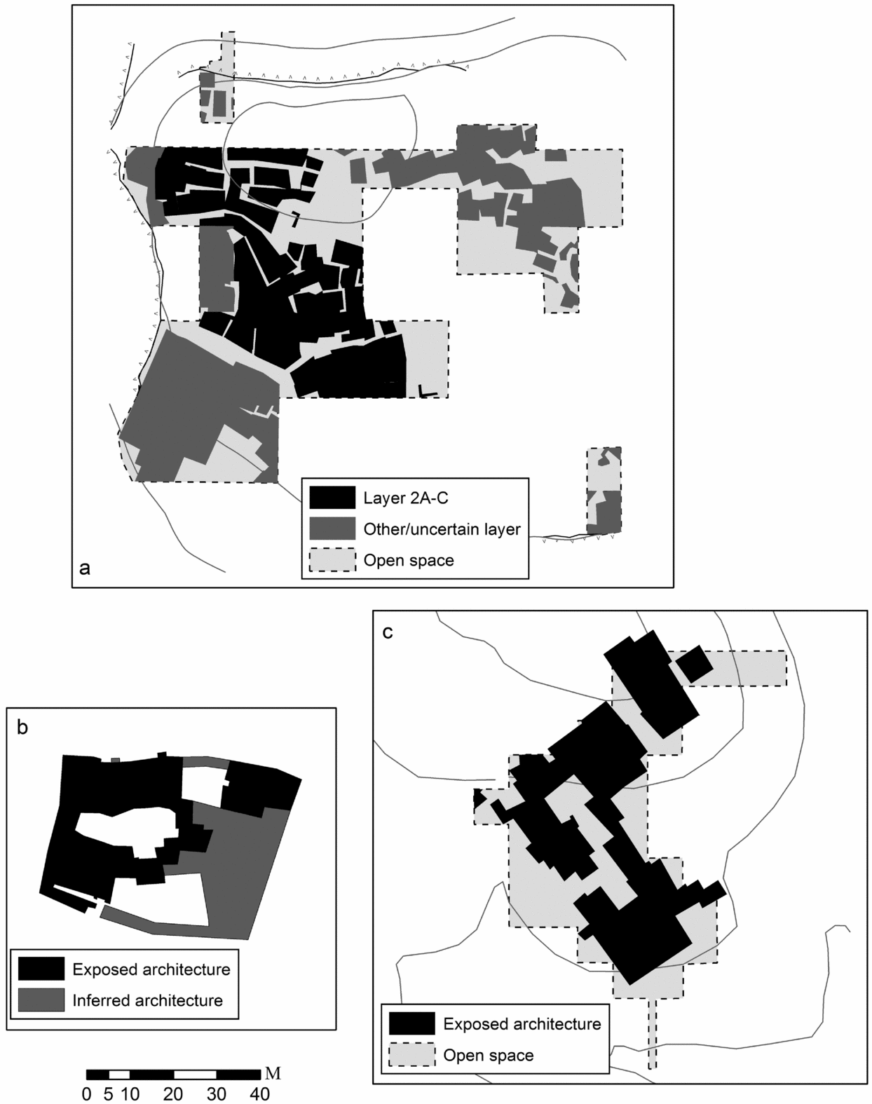
Domestic architecture at many Near Eastern Neolithic sites is exposed in only small windows, making site layouts difficult to discern, but in most large sites with broad exposures it is clear that settlements are not simply blocks of massed buildings. Instead, settlements are often characterized by what Düring (Reference Düring2006) terms ‘clustered neighbourhoods’ separated by streets, courtyards and alleys (Fig. 7). These architectural arrangements compare favourably to the configuration of room blocks on Southwestern pueblos. For example, Asikli Höyük has blocks of dense, agglomerative domestic architecture separated by pebble-paved streets and small courtyards (Esin et al. Reference Esin, Bıçakçi, Özbaşaran, Balkan-Atlı, Berker, Yağmur and Atlı1991; Esin & Harmankaya Reference Esin, Harmankaya, Özdoğan and Basgelen1999), and Tell Bouqras has clear evidence of streets between room blocks (Akkermans et al. Reference Akkermans, Fokkens, Waterbolk, Cauvin and Sanlaville1981). At Çatalhöyük, with the caveat that the stratigraphic levels identified by Mellaart (Reference Mellaart1967) in the southern part of the site and the wall alignments identified by surface scraping in the northern part of the site (Matthews Reference Matthews and Hodder1996) should not be considered discrete episodes of occupation, it is clear that the Neolithic architecture of the site is also organized into blocks of rooms separated by open spaces (Fig. 2a) (cf. Düring Reference Düring2006).
(a) Asikli Hoyuk (redrawn after Esin & Harmankaya Reference Esin, Harmankaya, Özdoğan and Basgelen1999, fig. 3, and Düring Reference Düring2006, fig. 4.10); (b) Hacilar (redrawn after Mellaart Reference Mellaart1970, 71–2); (c) Tell Bouqras (redrawn after Akkermans et al. Reference Akkermans, Fokkens, Waterbolk, Cauvin and Sanlaville1981, fig. 2). Contour interval 5 m in all maps.

While Southwestern pueblos show clear spatial patterning in residential and public spaces at a given point in time, layouts in long-lived Southwestern pueblos shifted sufficiently so that most of the site area, including open spaces, was often built on at least once. This phenomenon, known as ‘settlement drift’, has been documented in many areas of the world (e.g. Webb & Frankel Reference Webb, Frankel and Iacovou2004). Thus, although the surface of Southwestern pueblos is mounded in areas of repeated/multi-storey construction, trenches through plazas, streets and other open spaces often uncover wall foundations. For example, almost every sounding in non-rubble areas at Awat'ovi revealed evidence of buried rooms or plaza kivas (see Fig. 2b). At Çatalhöyük, occupied three times as long as typical large Southwestern pueblos, the effect would be even more pronounced and perhaps more difficult to disentangle, given the less precise chronological tools available (e.g. radiocarbon versus dendrochronology). The relatively well dated excavations at the Neolithic site of Tell Sabi Abyad in northern Syria (Akkermans Reference Akkermans, Akkermans, Bernbeck, Nieuwenhuyse and Rogasch2013; Akkermans et al. Reference Akkermans, Cappers, Cavallo, Nieuwenhuyse, Nilhamn and Otte2006) provide a clear example of multiple, chronologically separate, closely spaced occupations that joined together over time to form a continuous mound.
Cross-cultural patterns suggest that large settlements should include not just structured residential architecture, but spaces for communal ritual as well. Ethnographic studies show that group ritual is pervasive among ‘tribal’ societies (Johnson & Earle Reference Johnson and Earle1987, 20, 199–200), where it often serves as ‘a functional alternative to political power’ (Rappaport Reference Rappaport1971, 72). Large structures or spaces in which to perform these rituals are abundant in the archaeological record of sedentary ‘middle-range’ societies (e.g. Adler & Wilshusen Reference Adler and Wilshusen1990; Bandy Reference Bandy2004; Iriarte et al. Reference Iriarte, Moehlecke, Fradley, Lockhart and Gillam2013; Moore Reference Moore1996). Spaces for communal ritual have been documented at some, but not all, large Near Eastern Neolithic settlements. Small courtyards were apparently relatively common (see above), some of which, like the ‘monumental courts’ at Asikli Höyük, could have held 100 or more people, though at about 170 sq. m even these are relatively small by cross-cultural standards. The ‘mature aceramic’ levels of Çayönü, a 4 ha site in southeastern Turkey, contain a plaza measuring at least 50× 25 m with several large communal/ritual structures with floor areas in the range of 100 sq. m (Özdoğan & Özdoğan Reference Özdoğan and Özdoğan1989; Rosenberg & Erim- Özdoğan Reference Rosenberg, Erim-Özdoğan, McMahon and Steadman2011), double the size of the largest buildings exposed at Çatalhöyük and equivalent to ‘low range integrative structures’ found cross-culturally (Adler & Wilshusen Reference Adler and Wilshusen1990). Excavations at ‘Ain Ghazal did not expose broad areas of architecture, but even the small soundings revealed a possible courtyard wall suggestive of internal public spaces (Rollefson et al. Reference Rollefson, Kafafi and Simmons1992, 450). Communal architecture or sacred precincts are also known from a number of Levantine PPNB sites (e.g. Beidha, Atlit Yam and Jericho) (Goring-Morris & Belfer-Cohen Reference Goring-Morris, Belfer-Cohen, Bocquet-Appel and Bar-Yosef2008), though these are less compelling analogues given their geographic and chronological distance from Çatalhöyük. At Çatalhöyük, two of the 10×10 m squares in the middle of the tell exposed by surface scraping contained primarily burned midden deposits, suggesting the possibility of large, central open spaces (Matthews Reference Matthews and Hodder1996, 86). Scraping also revealed the foundations of a possible public building just to the west of these midden areas (Matthews Reference Matthews and Hodder1996, 87–8). Although the excavated and scraped areas at Çatalhöyük are large, they could easily miss substantial open spaces within the mound, especially since the largest excavated areas were selected precisely for their locations on mound high points and positive surface evidence for architecture. If similarly large units were placed on high rubble mounds at Awat'ovi, excavators could easily miss much of the open space present, misrepresenting the proportions of architecture and open space in the village.
The situation at Çatalhöyük boils down to whether the absence of evidence for large, public spaces can reasonably be interpreted as evidence of their absence. The fact that open spaces and public architecture are well documented at earlier and contemporary Neolithic Anatolian settlements of smaller size make it doubtful that a settlement the size of Çatalhöyük would lack them. Some researchers (e.g. Düring Reference Düring2006, 4, 304–6) have suggested that the decline in communal architecture from the PPNA through the Ceramic Neolithic reflects unspecified changes in social organization that defy the predictions of scalar group theory. The apparent decline in public spaces, however, coincides with a sharp increase in the size and stratigraphic complexity of Neolithic settlements, which together make it considerably more difficult and unlikely to discover large ritual structures/spaces. The factors discussed in this section suggest that the apparent absence of public integrative spaces at megasites like Çatalhöyük is most likely due to sampling issues rather than the behaviour of megasite residents (cf. Akkermans Reference Akkermans, Akkermans, Bernbeck, Nieuwenhuyse and Rogasch2013, 71–2).
Awat'ovi and similar large, Southwestern pueblos thus arguably provide a glimpse of what shorter windows of occupation might look like within the Çatalhöyük tell: areas of persistent occupation that formed tall mounds of residential debris separated by open spaces, but with sufficient stochastic variation in construction foci that the cumulative occupation covered most of the site's footprint with structures. Even in Southwest sites it is difficult to phase these building episodes without extensive excavation and the benefit of precise tree-ring-based chronologies.
Micro versus macro
We suggest that the data produced by different degrees of architectural visibility underlie contrasting interpretative emphases in the Near East and American Southwest. Because architecture in the Near East is often hard to delineate on the surface due to the decomposition of mud brick or burial by later components, field work has traditionally focused on excavation. Compared to the American Southwest, Near Eastern excavations generally have access to larger, cheaper labour pools enabling the movement of massive amounts of material; nevertheless, excavation is still time and money intensive, and whole sites are rarely exposed. Thus, for large Near Eastern Neolithic sites the interpretative emphasis is generally on room configurations exposed in deep soundings, rather than on the broader site layout.
Field work at large pueblos in the American Southwest, in contrast, has typically focused on mapping total site layouts, because sites are often not deeply buried, architecture is frequently visible on the surface and sites were occupied for relatively short periods of time, precluding the necessity of deep, stratigraphic excavations to establish the configuration of blocks of domestic architecture. Although in the past it was common for Southwest archaeologists to hire large pools of local labourers, and some large pueblos were nearly completely excavated, this practice largely fell out of favour after the Second World War and was replaced by the paying labour of field-school students. These earlier projects remain our only spatially extensive excavated samples of late prehispanic pueblo architecture, although only the most recent of these projects, such as the excavation of Grasshopper Pueblo (Reid & Whittlesey Reference Reid and Whittlesey1999), occurred using high-resolution, modern data recovery methods (e.g. screening, flotation, etc.) that enable the types of artefact analyses now common in household archaeology. Large-scale excavations of Ancestral Pueblo sites have declined considerably in size and frequency in recent years due to changes in expenses related to excavation and curation, as well as pressure from Native American tribes to reduce archaeological impact on ancestral sites. Although excavations still occur, broad exposures of full household suites are rare and usually restricted to smaller, earlier settlements. With fewer broad horizontal exposures of large, late pueblos, Southwestern archaeologists know less about precise room configurations, doorway access, or rebuilding through time than our Near Eastern colleagues. Surface visibility on Southwestern pueblos is good enough, however, that public spaces and ritual architecture are generally well documented.
In light of these qualities of Near Eastern and Southwestern data recovery, it is not surprising that publications on Çatalhöyük and other large Near Eastern Neolithic sites tend to emphasize the household (e.g. Atalay & Hastorf Reference Atalay and Hastorf2006; Boivin Reference Boivin2000; Düring & Marciniak Reference Düring and Marciniak2005; Hodder Reference Hodder2006; Hodder & Pels Reference Hodder, Pels and Hodder2010), while publications on Awat'ovi and other large Southwestern villages tend to emphasize supra-household groups (e.g. clans, sodalities, moieties) and communal ritual and integration (e.g. Adams & Duff Reference Adams and Duff2004; Kolb & Snead Reference Kolb and Snead1997; Rautman Reference Rautman2000; Spielmann Reference Spielmann1998; Varien & Potter Reference Varien and Potter2008).
A ‘micro’ bias in Near Eastern archaeology may explain why small-scale social units are invoked as a mechanism for ameliorating the scalar stress of a larger population. Düring (Reference Düring2006, 235, 305; Reference Düring and Birch2013) for example, suggests that the heavy investment in household-level symbolism in ’lineage houses’ at Çatalhöyük took the place of larger-scale integrative spaces. Supra-household decision-making units like sodalities likely were present at Çatalhöyük, but by themselves would have been insufficient to ameliorate scalar stress in such a large community; sodalities were ubiquitous in larger villages in the Southwest (Mills Reference Mills and Hodder2014; Ware Reference Ware2014), but alone they never enabled populations comparable to the consensus estimates for Çatalhöyük.
Overestimation
Archaeology is never conducted in a social vacuum. Examples of archaeological interpretations distorted by a nationalism, for example, are well documented (Kohl Reference Kohl1998). Less obvious to the public, but often discussed within the archaeological community, are biases stemming from the motivation to make primeval or magnitudal discoveries: the first, the oldest, the largest, the exceptional. Such discoveries attract media attention and increase the odds of academic promotion and funding.
James Mellaart (Reference Mellaart1964) explicitly advertised Çatalhöyük as the ‘first city’, pre-dating the earliest known examples by some 3000 years and dramatically contradicting the evolutionary paradigms in Braidwood's (Reference Braidwood1948) influential Prehistoric Men. The site's continued fame stems in part from this early claim, which still appears in publications aimed at a public audience (e.g. an Archaeology Magazine article titled ‘The World's First City’: Shane & Küçük Reference Shane and Küçük1998). The legacy of early claims for urban densities may make high population estimates appear more plausible than they might otherwise be. It is worth emphasizing that Cessford (Reference Cessford and Hodder2005, 326) noted that ‘it is possible to produce population figures for Çatalhöyük in the region of 1500– 2000 inhabitants by consistently minimizing all assumptions’, although this observation is almost never cited by others.
Historical continuity
A final factor that may contribute to differing interpretations of Çatalhöyük and Awat'ovi is the perception of continuity with later time periods. Geographic, cultural, religious and linguistic continuity is markedly evident among Pueblo populations of the American Southwest. Although Spanish contact and missionization was disruptive for many populations and catastrophic for others, contemporary Puebloan tribes are the clear descendants of the occupants of villages like Awat'ovi. Oral traditions preserve information about village names, migration routes, and even ceremonies, many of which can be substantiated by archaeological evidence (e.g. Bernardini Reference Bernardini2005). Pueblo populations received more attention from ethnographers in the late 1800s and early 1900s than almost any other area of the world, with the result that they have become entrenched in the literature as archetypal ‘tribal’ societies (Bernardini & Adams Reference Bernardini, Adams, Mills and Fowles2017). Social hierarchy is present in contemporary and ancient Pueblo societies, but tends to be grounded more in control of ritual than in control of agricultural surplus or economic wealth (e.g. Potter & Perry Reference Potter, Perry and Mills2000)—a strategy that fits with an arid landscape in which intensification is difficult, but which is not typically associated with ‘urban’ scale populations (see Kohler et al. Reference Kohler, Smith, Bogaard, Feinman, Peterson, Betzenhauser and Pailes2017).
In contrast, it is unclear how the Neolithic population of Çatalhöyük relates to developments in the subsequent Chalcolithic period (Thissen Reference Thissen, Gerard and Thissen2002), making it easier to jump to comparisons of urbanism in later time periods, even though the earliest urban centres in the Near East arose in different regions and cultural contexts. Cultural links to contemporary populations are also less clear for Çatalhöyük than for pueblos of the American Southwest; contemporary populations around Çatalhöyük express more concern about financial connections to the site than ancestral ones (e.g. Atalay Reference Atalay2012). The perception that Çatalhöyük is a key to the larger historical trajectory of the Near East provides a strong incentive to connect the site to later time periods. Sitting on the edge of the Fertile Crescent, Çatalhöyük is part of the region that gave rise to some of the earliest complex civilizations in the world. The historical trajectory of the Near East, while certainly not linear, nevertheless has a clear direction culminating in cities and states by the fourth millennium bc. When Near Eastern archaeologists (primarily those working in Anatolia) discuss the relationship of Çatalhöyük to later time periods, it is often in the context of historical trajectories and the degree to which developments at Çatalhöyük (e.g. aggregation, urban architecture) anticipate or set the stage for more complex settlements (e.g. Der & Issavi Reference Der and Issavi2017; Mazzucato Reference Mazzucato2016; Redman Reference Redman1978). This perspective may encourage a more liberal approach to population estimates, producing totals compatible with hierarchical forms of organization and more in line with a trajectory that led to cities.
Conclusion
The question we have addressed is whether Çatalhöyük and other Near Eastern Neolithic megasites are exceptional in terms of their large population size and dense, undifferentiated residential spaces, or whether they have been misinterpreted as such. Our cross-cultural comparison with sites of similar size but shorter occupation spans in the American Southwest suggests that the latter explanation is quite likely. We argue that even the relatively large horizontal exposures at Çatalhöyük are insufficient to reveal the site's layout, and that pueblos from the American Southwest provide cautionary examples revealing the difficulty of identifying open spaces in deeply buried sites. We suspect that large population estimates for Çatalhöyük are accepted by some Near Eastern archaeologists in part because there are insufficient site-level data to refute them (cf. Akkermans Reference Akkermans, Akkermans, Bernbeck, Nieuwenhuyse and Rogasch2013). We suggest that differences in the interpretation of Çatalhöyük and Awat'ovi are the product of biases in their respective regional intellectual traditions more than unambiguous differences in the material record.
These conclusions help to resolve some of the mystery of Çatalhöyük and other Near Eastern Neolithic megasites and place them within a more conventional interpretive framework. We interpret Çatalhöyük site as a large village, analogous to large pueblos from the American Southwest, whose internal structure likely included open spaces or community structures that facilitated the organization and integration of its population. Even in the American Southwest, with visible surface architecture and strong ethnographic analogues, distinguishing communal from residential structures can be difficult (Lekson Reference Lekson1988); difficulties in identifying similar features at Çatalhöyük and other sites may in part derive simply from the difficulty of differentiating structures of specialized function without access to emic understandings of what their physical and symbolic markers may be (Mills Reference Mills and Hodder2014).
Our purpose here is not to say that Çatalhöyük and other Near Eastern Neolithic megasites were the same as their contemporary peers in size or social importance, but that invocation of population sizes more commensurate with urban settlements that date to millennia later is unnecessary and not well supported empirically. Clearly, Near Eastern megasites outstripped nearby settlements in their ability to attract residents, and must have exerted considerable influence on the surrounding social and physical landscape. Nor are we suggesting that the work of some of our Near Eastern colleagues is fundamentally flawed by shortcomings of methodology or interpretation. Rather, these sites are so large, both physically and in terms of their intellectual heft, that interpretation is doubly difficult. We propose that thinking about these sites and their interpretive challenges in new ways can help us to escape the constraints of past interpretations and highlight new questions that need to be asked of them in the future.
Acknowledgements
A version of this paper was originally presented in a session titled ‘Bridging the gap: a comparative examination of mapping landscapes in antiquity’ at the 2016 Annual Meeting of the American Anthropological Association. We thank Elizabeth Carter, Hannah Lau, Bernd Müller-Neuhof and three anonymous reviewers for their insightful commentary on prior drafts. Fieldwork at Awat'ovi was conducted under permits issued by the Hopi Cultural Preservation Office and with funding from the University of Redlands and the Farquhar Chair of the Southwest Endowment. We thank Leigh Kuwanwisiwma, Lee Wayne Lomayestewa, Joel Nicholas and Stewart Koyiyumptewa for facilitating and participating in our fieldwork. Any errors of interpretation or omissions herein are our own responsibility.