


Introduction
Remarkable progress has been made over the past five years in understanding the later prehistory of the Maghreb, the results of which have major implications for interpretations of broader Mediterranean and northern African dynamics. Although much still remains to be established, and gaping lacunae persist, the heady pace of progress (recently summarized in Benattia Reference Benattia2025) can be measured by comparing the current state of knowledge with that only a few years ago (Broodbank and Lucarini Reference Broodbank and Lucarini2019; Lucarini et al. Reference Lucarini, Bokbot and Broodbank2021). In particular, the site of Oued Beht, located in a Mediterranean-type environment in Khémisset Province, northwestern Morocco, on a ridge-top overlooking a perennial river, is emerging as a pivotal location for generating new knowledge and understanding of the later prehistory of this region (Figure 1). As previously reported, fieldwork in 2022 by the Oued Beht Archaeological Project (OBAP) revealed unexpected evidence for a large, complex focus of activity spread over 9–10 hectares across the ridge, associated on the basis of botanical and faunal remains with an primarily agriculturally-based society, and radiocarbon-dated from the mid-to-late fourth to earliest third millennium BC (Broodbank et al. Reference Broodbank, Lucarini, Bokbot, Benattia, Bigoulimen, Brucato, Farr, Garcia-Molsosa, Hachami, Laoutari, Lombardi, Marsilio, Martin, Martínez Sánchez, Mazzini, Morales, Radi, Rega, Sulas and Wilkinson2024a and Reference Broodbank, Lucarini, Bokbot, Benattia, Bigoulimen, Farr, Garcia-Molsosa, Hachami, Laoutari, Lombardi, Marsilio, Martin, Morales, Radi, Rega and Wilkinson2024b for details of the topography, site, field project and initial discoveries). This activity belongs to a hitherto all but unknown Final Neolithic phase that parallels (and interacted across the sea with) contemporaneous developments in transitional Neolithic to Copper Age southern Iberia. Whether this signature at Oued Beht reflects the remains of a big village, or something less familiar, remains to be established, but already it is clear that the site acted as a hub for production and consumption of prodigious numbers of polished stone axes and other lithic tools, as well as elaborate, sometimes pattern-painted, pottery. It was also a place of storage (most plausibly of crops) on a considerable scale, to judge by the numerous bell-shaped pits found. Such insights are complemented by new fieldwork further north at Kach Kouch, near the Mediterranean coast, and elsewhere around Tangier (Benattia et al. Reference Benattia, Bokbot, Onrubia-Pintado, Benerradi, Bougariane, Bouhamidi, Carballo-Pérez, Echcherif-Baamrani, Elqably, Ghayati, Hachami, Kbiri-Alaoui, Lazarescu, Lombardi, Lucarini, Martínez-Sanchez, Mateu-Sagués, Menéndez-Molist, Montero-Ruiz, Ouakrim, Pérez-Jordà, Radi, Ramon-Torres, Sobrevia-Corral, Touri and Broodbank2025a, Reference Benattia, Onrubia-Pintado and Bokbotb), where communities of the later second to early first millennium BC are starting to be revealed. Increasingly, genetic evidence can also be brought to bear on issues of descent and mingling at this junction of the Mediterranean and Saharan worlds (Simões et al. Reference Simões, Günther, Martínez-Sánchez, Vera-Rodríguez, Iriarte, Rodríguez-Varela, Bokbot, Valdiosera and Jakobsson2023; Lipson et al. Reference Lipson, Ringbauer, Lucarini, Aouadi, Aoudia, Belhouchet, Cheronet, Dahmani, Genchi, La Pastina, Lucci, de Lumley, Mansouri, Nava, Touj, Mallick, Rohland, Coppa, Pinhasi and Reich2025 for a comparison with the eastern Maghreb). These discoveries prepare the springboard for a new, long-term archaeological history of this region, from the spread of farming to the pre-Roman (far more than ‘Phoenician’) Iron Age.
Regional topographic relief map with Oued Beht and other sites mentioned in the text (KK: Kach Kouch; Ri: Rirha; Sa: Sala; Vo: Volubilis) (map: TW).

In further pursuit of this re-evaluation of the northwestern Maghreb’s later prehistory, we here present and provisionally interpret subsequent discoveries at Oued Beht that derive from OBAP’s third field season, from 30th October to 17th November 2023. The emphasis is on fieldwork results augmented by selected insights from associated study and analysis up to April 2024. The broader study of material culture and bioarchaeology is not reported in detail, except as directly relevant to the new excavation and survey results, as the analysis of these data remains ongoing and fluid. The preliminary results previously reported for categories of material culture, fauna and botanical remains, in fact still broadly stand, reinforced, if also nuanced, by expanded and more varied samples (for example, in the case of the botanical remains, further evidence from the prehistoric phases of hulled and naked forms of barley, durum wheat, pea and wild olive and pistachio, but also wild carob and jujube, plus a range of weed species). OBAP’s focus remains on later prehistory, and not least the confirmation (following hints during the 2022 season) of a subsequent, early-to-mid-second millennium BC activity phase at Oued Beht after the Final Neolithic, focused on a substantial ditch and embankment construction at the southern end of the site. But, inevitably, intriguing light is cast on later periods, too, and most significantly both settlement and funerary activity on and surrounding the ridge during the Middle Islamic (medieval) period, which contribute fresh perspectives on the longer-term microcosmic history of the Oued Beht landscape.
The 2023 field season addressed four strategic questions, building upon knowledge previously gained, and in addition to further developing previous lines of exploration:
1. Of what date are the linear walls/embankment features in the Southern Sector?
The most prominent of these have been noted and documented since the first visits in the 1930s, and underpinned the original identification of a presumed prehistoric ‘éperon barré’ (Ruhlmann Reference Ruhlmann1936: 44–50), but their dating in fact was very uncertain (Figure 2). Unpublished French–Moroccan excavations by the Complexe Archéologique de Oued Beht (CAOB) project in 2013–15 proved inconclusive regarding the two largest features, establishing definite post-prehistoric construction phases but without assurance that these represented the earliest building activity. If a prehistoric origin could be demonstrated, and precisely dated, this would mark a substantial advance in understanding, and potentially prove to be of wider regional significance.
(a) Oblique drone photograph of the so-called ‘éperon barré’, with the village of Aït Siberne in the background (east-facing); (b) Vertical drone photograph of the ‘éperon barré’; 1. Trench 3/3.1 on Wall B1; 2. Trench excavated by CAOB; 3. R2 trench excavated by CAOB on Wall C (photographs: TW).

2. Is there a cemetery associated with the site?
In 2022 local people reported to OBAP their encounters with human remains during recent house-building and other work at the northern edge of the site. This clearly needed verification and, crucially, dating, with the tantalising prospect of contemporaneity with one or more phases of prehistoric activity – and all the informational potential pertaining to human remains of such age in northwestern Morocco.
3. How does intra-site spatial and chronological patterning of activity vary across the site?
Although obviously a more open-ended question, the 2022 survey had already highlighted differential spatial patterning between the Northern and the Southern Sectors (the latter area now also the focus of Question 1, above), especially regarding prehistoric diagnostics of potentially chronological significance. It also identified taphonomic distinctions within the Northern Sector, between its most elevated and best investigated part, and the less known northwestern area, which had been less subjected to destructive modern tree-pitting, and where later sub-surface prehistory was thought likely to exist on the basis of surface finds.
4. What is the pattern of prehistoric and later activity in the wider environs of Oued Beht?
The 2022 survey established the first detailed understanding of the spread of prehistoric and later material over the core of the Oued Beht ridge, but did not extend into the immediate surroundings. Were there other sites in the immediate vicinity, whether earlier, later, or contemporary with the Final Neolithic focus? And how might small-scale intensive survey inform approaches to investigating the vaster extent of the surrounding landscape, which remains almost entirely unknown in empirical terms and anticipatable temporal patterning?
As will be seen, the 2023 season answered the first two questions decisively (if in the second case perhaps not as hoped!), substantially advanced the third, and answered the fourth within a localized spatial framework. In addition, geological survey in tandem with the field season improved our knowledge of the formation of the Oued Beht ridge, and the availability of lithic and mineral resources there and in its surroundings. This was followed in early 2024 by an investigation of the resources for local pottery manufacture, undertaken in conjunction with a programme of ceramic sampling for petrographic and chemical analysis to explore questions of provenance and technology.
Excavation
Six new trenches were opened in the 2023 season (see Figure 3 for locations). In the south, the elongated slit Trench 3 and its offset extension Trench 3.1 investigated the sequence and dates of the walls, embankments and (as it transpired) ditch previously referred to as ‘Wall B1’. Trench 4, an open 5 x 5 m exposure, explored the nature of deposits at the heart of the Northern Sector, adjacent to previous excavations by the French-Moroccan CAOB project in 2016–17. The small trial Trenches 5, 6 and 7 were located to probe the area of a potential cemetery in the far north. Trench 8 was a similarly small trial to examine the sub-surface evidence in the hitherto untouched northwestern part of the site, The results from all these trenches are reported in detail below. In addition, part of a 2017 CAOB trench south of the Maison Forestière (probably their Tranchée 1/11) was re-opened to check for a putative constructional feature. This proved inconclusive, though as with similar operations in 2022 a large amount of re-dumped pottery and bone was found in the 2017 backfill. As no controlled excavation was undertaken in this last operation, no OBAP trench number was assigned. All excavations were conducted by hand using a single-context method and cultural material was collected by stratigraphic unit. The horizontal surfaces of contexts were planned at a scale of 1:20 followed by photography, colour assessment by Munsell Soil Chart and comprehensive notes on the composition of each context. Upon completion of each trench, all sections were photographed and drawn at a scale of 1:10. Additionally, each trench was recorded with photogrammetry, a three-dimensional visual record that added depth and detail to the written documentation. Once recorded, trenches were covered with tarpaulin and backfilled to ensure preservation and integrity for further investigation.
Plan of the site, with the excavated trenches, major walls and surface features (map: TW).

Figure 3 Long description
The map depicts the Cave of Ifri nAmr oMoussa, highlighting excavated trenches, major walls and surface features. Trenches from 2021 to 2023 are labeled, including 2023/T3, 2023/T3.1, 2023/T4, 2023/T5, 2023/T6, 2023/T7 and 2023/T8. Trenches from 2022 are marked as 2022/T1 and 2022/T2, while 2021/T101 is also shown. Walls are labeled as Wall A, Wall B1, Wall B2, Wall C and Wall D. Excavations are categorized as OBAP and CAOB, with OBAP marked in red and CAOB in black. Visible structures include walls and other features, with walls marked in gray and other structures in orange. The map includes features labeled F9, F10, F11, F13, F14s, R1 and R2. The scale bar indicates 100 meters and the map is oriented with north at the top.
Twenty-four new radiocarbon dates from the 2023 trenches are presented in Figure 4 and Table 1. Tables 2–7 include, where available, very preliminary assignment of features and contexts to provisional phases. At present four site-wide phases have been identified, based either on calibrated radiocarbon date clusters or unequivocal material culture links (in the case of latest phases): Neolithic (NEO), provisionally (see below) Bronze Age (BA), Historic (HIS) and Modern (MOD). In practice the ‘Historic’ phase applies to contexts from approximately AD 1000 to AD 1900, with all 20th- and 21st-century contexts considered ‘Modern’. The bounds of these site-wide phases naturally may be adjusted in the future as more data becomes available.
Radiocarbon dates obtained from 2023 excavations, expressed as probability densities on a BC/AD scale with associated period groupings marked above. Those dates whose calibration postdates 1950, and hence may fall out of range, are coloured grey (elaboration: TW).

Figure 4 Long description
NEOLITHIC BRONZE AGE HISTORIC MODERN. The x-axis is labeled 4000BC, 3000, 2000, 1000, 1, 1000, AD2000. No y-axis label is shown. Multiple horizontal probability density curves are stacked vertically, each labeled at the left of its curve. Neolithic group labels and curves: FTMC to VC13 to 10 (T4:622.01), FTMC to VC13 to 8 (T4:621.01), LTL33693 (T3:415), LTL33697 (T4:619), FTMC to ML47 to 2 (T3:412). Bronze Age group labels and curves: LTL33695 (T3:442 approximately 413), LTL33694 (T3:473), FTMC to VC13 to 7 (T3:439.01), FTMC to VC13 to 5 (T3:473), FTMC to VC13 to 6 (T3:474), FTMC to VC13 to 4 (T3:431 approximately 413), FTMC to ML47 to 1 (T3:405), FTMC to VC13 to 2 (T3:419), LTL33696 (T3:426). Historic group labels and curves: FTMC to ML47 to 6 (T3:468), FTMC to ML47 to 7 (T3:469), FTMC to VC13 to 3 (T3:428), FTMC to ML47 to 3 (T3:453.02), FTMC to XC80 to 1 (T7:833.02), LTL33698 (T4:611), LTL33700 (T8:1002.01), FTMC to VC13 to 9 (T4:621.01). Modern group labels and curves: FTMC to ML47 to 5 (T3:467), FTMC to ML47 to 4 (T3:462). Each curve shows one main peak or a small cluster of peaks along the x-axis scale, with the Neolithic curves positioned near the 4000BC to 3000 range, the Bronze Age curves near the 2000 to 1000 range and the Historic and Modern curves near the 1 to AD2000 range.
Radiocarbon dates obtained from trenches excavated in 2023. Radiocarbon date ranges were generated using the maximal and minimal edges of the 95.4% probability mass envelope using the HPDI method; calibration was performed with the rcarbon package for R (Crema and Bevan Reference Crema and Bevan2021) using the IntCal20 curve (Reimer et al. Reference Reimer, Austin, Bard, Bayliss, Blackwell, Bronk Ramsey, Butzin, Cheng, Edwards, Friedrich, Grootes, Guilderson, Hajdas, Heaton, Hogg, Hughen, Kromer, Manning, Muscheler, Palmer, Pearson, van der Plicht, Reimer, Richards, Scott, Southon, Turney, Wacker, Adolphi, Büntgen, Capano, Fahrni, Fogtmann-Schulz, Friedrich, Köhler, Kudsk, Miyake, Olsen, Reinig, Sakamoto, Sookdeo and Talamo2020)

Table 1 Long description
Radiocarbon dating results are not shown because the table contains no rows or columns of data. No sample identifiers, trench labels, measured radiocarbon ages, calibrated date ranges, or uncertainty information are present. No comparisons or trends can be described from the table content.
* date may extend out of range
Archaeological phasing, features and contexts of Trench 3/3.1 (Phase: NEO: Neolithic; BA: Bronze Age; HIS: Historic; MOD: Modern; Feature type: D: Discrete; E: Earthwork; L: Linear; M: Masonry; Context type: C: Cut; F: Fill; L: Layer; M: Masonry)
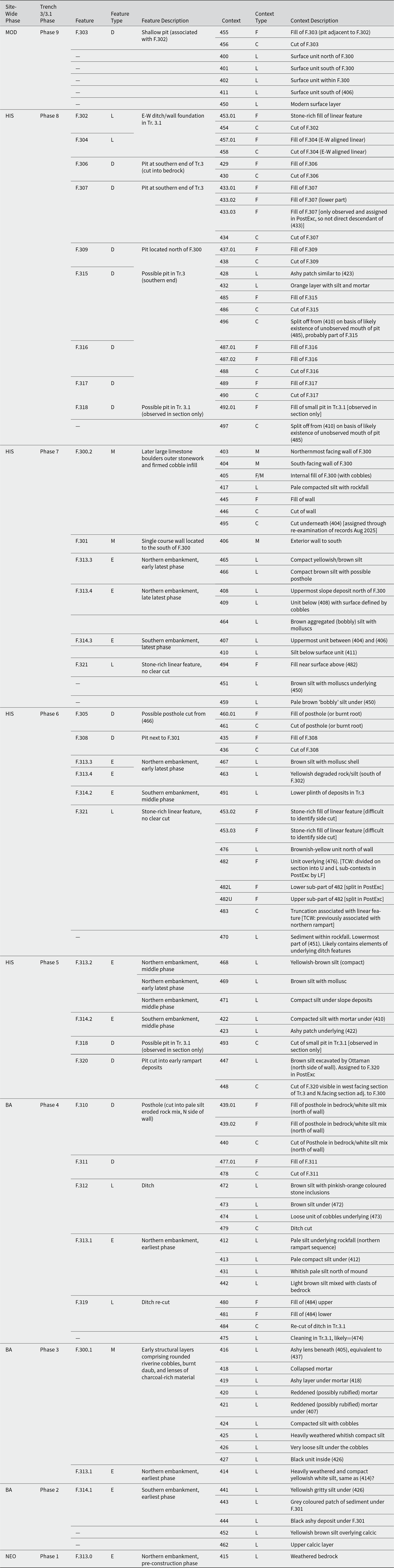
Table 2 Long description
The table is intended to list archaeological phasing along with feature and context information for a trench. No rows, columns, headers, or values are present in the provided table data. Because the table content is missing, no phases, feature types, or context types can be read or compared.
Archaeological features and contexts of Trench 4 (Feature type: D: Discrete; L: Linear; P: Pit; Context type: C: Cut; F: Fill; L: Layer)

Table 3 Long description
Table data are present. Column headers, row labels, and cell values for feature type and context type are not provided. Counts, identifiers, and any comparisons across features or contexts cannot be read from the table.
Archaeological features and contexts of Trench 5 (Feature type: D: Discrete; G: Grave; L: Linear; Context type: C: Cut; F: Fill; L: Layer)

Table 4 Long description
Table data are shown. No column headers, row labels, feature identifiers, or context identifiers are provided. No feature types or context types appear, and no counts, measurements, or descriptions are listed.
Archaeological features and contexts of Trench 6 (Feature type: D: Discrete; Context type: C: Cut; F: Fill; L: Layer)

Table 5 Long description
The table is intended to list archaeological features and contexts for Trench 6, using feature type and context type codes. No rows, columns, labels, or values are present in the provided table data. Because the table content is missing, no feature types, context types, or counts can be described.
Archaeological features and contexts of Trench 7 (Feature type: D: Discrete; G: Grave; L: Linear; P: Pit; Context type: C: Cut; F: Fill; L: Layer)

Table 6 Long description
The table is intended to list archaeological features and contexts for Trench 7, with feature types and context types. No rows, columns, labels, or values are present in the provided table data. Because the table content is missing, no feature types, context types, counts, or comparisons can be described.
Archaeological features and contexts of Trench 8 (Feature type: D: Discrete; P: Pit; Context type: C: Cut; F: Fill; L: Layer)

Table 7 Long description
Table data are present. Column headers, row labels, and cell values for archaeological features and contexts are not provided. Counts, context numbers, feature types, and context types cannot be read or summarized from the table.
Trench 3/3.1 (NW corner of Trench 3 = SW corner of Trench 3.1: UTM 29N, 783640, 3753406)
Trench 3 and its offset extension 3.1 comprised the largest excavation undertaken in 2023 (Figures 5–7, Table 2). The aim was to understand the nature and chronology of the standing feature known as ‘Wall B1’, by far the most massive of four east–west built alignments traversing the Southern Sector of the Oued Beht ridge (Wall A, to its north, had been established in 2022 to be of fairly recent date, and superficial as preserved). It seemed likely from surface inspection that ‘Wall B1’ was in fact shorthand for a potentially complex accumulation of walling, embankment and negative features, that took topographical advantage of a geological contact line running across the ridge and down the steep eastern slope (see below for the geological context). According to Ruhlmann’s neat but unproven reconstruction, this formed part of a prehistoric éperon barré that was completed by its slighter north–south return as Wall B2 , discontinuously as currently preserved along the ridge’s western scarp and by the more modest Wall C to its south (Ruhlmann Reference Ruhlmann1936, 44–50, figs 2–4 and pl. 1, for his interpretation as a defensive ‘rampart’ and enclosure, as well as contemporaneous photographs and a sketch section). Local residents recall the uppermost stonework being more substantial in recent memory, as well as its incorporation as an animal stable. Wall B1 and Wall C were explored by the CAOB project in the 2010s, as witnessed by the remnants of still-open trenches, with ambiguous results in terms of dating, beyond a recognition that the upper phases produced clearly post-prehistoric material. Wall B1 was of particular interest to OBAP not only as the largest standing monument visible at Oued Beht (and still of undated origin), but also because the 2022 survey had revealed surrounding indications of prehistoric activity, some of which arguably post-dated the Final Neolithic phase dominant elsewhere on the site (most convincingly in the case of the chipped stone, but supported by hints from the macrolithics and pottery; Broodbank et al. Reference Broodbank, Lucarini, Bokbot, Benattia, Bigoulimen, Brucato, Farr, Garcia-Molsosa, Hachami, Laoutari, Lombardi, Marsilio, Martin, Martínez Sánchez, Mazzini, Morales, Radi, Rega, Sulas and Wilkinson2024a: 18–21, 33–38). The 2022 survey had also noted in the same area abundant post-prehistoric, mainly unglazed, pottery of not obviously recent date. Given these observations, and the notable distance of Wall B1 from the core of the Final Neolithic distribution in the Northern Sector, excavation here was expected to substantially expand the understanding of activity across the Oued Beht ridge over time. This expectation was spectacularly fulfilled.
Trench 3: (a) F.300.2 (Wall B1), (east-facing); (b) F.300.2 (Wall B1), (west-facing); (c) Section of F.300.2 (Wall B1) and F.300.1 (earlier wall), (east-facing); (d) Trench 3 section (southern portion, northeast-facing); (e) Trench 3 section (southern portion, southeast-facing) (photographs: LF and GL).

Trench 3 and 3.1: (a) Trench 3, section of embankment deposits (F.313.1 and F.313.4) to the north of F.300.2 (Wall B1), (west-facing); (b) Full extent of Trench 3.1, (southwest-facing); (c) Trench 3.1 section, showing ditch (F.312), re-cut ditch deposits (F.321) and wall F.302, (east-facing); (d) Section of embankment deposits (F.313.2–4) and on left wall (F.302)/re-cut ditch deposits (F.321), southern end of Trench 3.1 (east-facing) (photographs: LF).

Trench 3/3.1: Section profile across the rampart/embankment and ditch complex, showing features and contexts visible in section and associated radiocarbon dates (drawing: ABr, LF, MR).

Figure 7 Long description
The diagram consists of two section profiles labeled Trench 3 and Trench 3.1, each showing various archaeological features and contexts. Trench 3 is on the left, displaying layers with labeled features such as pottery sherds, malacofauna, charcoal, bones, rocks, and disturbances or rooting. Radiocarbon dates are marked throughout, including 1053 to 1344 cal. BC, 1505 to 1624 cal. BC, and 993 to 1157 cal. AD. Various features are labeled with numbers like F294, F295, and F296, indicating specific archaeological contexts. Trench 3.1 is on the right, similarly showing layers with features and radiocarbon dates such as 3623 to 3371 cal. BC, 1729 to 1594 cal. BC, and 1048 to 1212 cal. AD. Features are labeled with numbers like F301, F302, and F303. The diagram includes a legend at the bottom indicating symbols for pottery sherds, malacofauna, charcoal, bones, rocks, and disturbances or rooting. A scale is provided at the bottom right, along with directional arrows indicating north and south. The diagram is detailed with specific archaeological contexts and chronological information, providing a comprehensive view of the excavation profiles.
The objectives of excavating Trench 3/3.1 were (1) to characterize the form, nature and age of the stone walls, establishing whether multiple walling phases could be identified; (2) to confirm phase and date of the underlying embankment; (3) to explore for any associated ditch; and (4) to establish a reliable chronology and interpretation of the overall sequence of features and deposits. The offset at the northern end of Trench 3 to create 3.1 was prompted by safety concerns, given the mass of overlying stones, and to preserve a mature olive tree. In pursuit of environmental data and radiocarbon dates, representative bulk samples of ca.10–20L were taken from stratigraphic units for flotation, and fill from cut features was 100% bulk sampled where possible, avoiding frequent areas of marked bioturbation and impaired visibility due to tree roots, clusters of bulbs and animal burrowing. As seen in Figures 7 and 8a, the stratigraphy proved to be complicated, involving multiple phases of construction, use, destruction/abandonment and reuse. Dating these proved challenging, not least because for many small contexts the number of finds (largely pottery) was too small to be reliable, while even some of the larger contexts yielded material of mixed prehistoric and later date, as expected given extensive reworking of the area over time and possible introduction of soil from elsewhere on the ridge. However, in addition to the suggestively persistent presence of the prehistoric pottery in mixed contexts, a number of substantial, clean prehistoric contexts were identified with an adequate sample of exclusively prehistoric sherds, mainly low in the stratigraphic sequence. Little of this pottery was more finely datable on present knowledge. But 17 radiocarbon dates (eight on seeds and nine on charcoal) from Trench 3/3.1 demonstrated for the first time beyond doubt a major phase of early–mid-second millennium BC construction in this area, bracketed by slight Final Neolithic traces and substantial medieval activity (Figure 4; Table 1). In terms of usefulness, 15 of these dates provided good terminus post quem ranges logically consistent with stratigraphic position and comingled artefacts for the relevant contexts. The remaining two (items 1 and 2 in Table 1, respectively FTMC-ML47-4 and FTMC-ML47-5) can only be explained as intrusive travellers (significantly both on charcoal, identified secondarily after flotation) and were disregarded for phase assignment of contexts. They are not further discussed here. All cited radiocarbon dates hereon are calibrated AD/BC unless otherwise specified.
Trench 3/3.1: (a) Relative trench-specific archaeological phasing; (b) Ceramic dating by context (drawings: ABr, LF, MR; elaborations: TW); (c) Vertical drone photograph of Trench 3 (south) and Trench 3.1 (north), showing features and contexts visible in plan (photograph and elaboration: TW).

Figure 8 Long description
Two trench-profile drawings for Trench 3 and Trench 3.1. A legend lists Phase 9, Phase 8, Phase 7, Phase 6, Phase 5, Phase 4, Phase 3, Phase 2, Phase 1, and Unclear. The phase categories are applied as contiguous blocks along each profile, with boundaries between blocks following the drawn stratigraphic edges. The image B showing two trench-profile drawings for the same two trench segments. The legend lists Clean PREHIST, Mixed (POSTPRE less than 5 percent), and Mixed. The legend also lists sample size greater than 10 and sample size less than or equal to 10, shown as two symbol styles applied over the classified areas. The category blocks follow the same profile shapes as in A. The image C showing a plan view of Trench 3 and Trench 3.1 with many labeled features and context numbers. Labels include Trench 3 and Trench 3.1, F.312 ditch, F.319 recut, and F.321 wall. Additional labels visible include F.311, F.303, F.302, F.305, F.304, F.318, F.310, F.320, F.309, 439.01, 415, 403, 404, 406, 447, F.300.2 slash Wall B1, F.313 northern side of embankment, F.314 southern side of embankment, F.308, F.315, F.316, F.317, 485, F.307, and F.306. Several semi-transparent rectangular overlays sit across the central part of the plan, aligned with the trench area. No north arrow or scale bar is visible.
Trench 3
Excavation began by re-opening and cleaning a shallow CAOB trench atop Wall B1, and then extending it in both directions along a north–south alignment, ultimately to measure 14.2 m in length and 2.5 m in width. Excavation depths varied, with maxima of 1 m, 1.35 m and 45 cm in the north, centre and south, respectively. Bedrock was reached at varied depths between ca. 40 cm and 1 m, and consisted of a heavily weathered and fractured, partially lithified, carbonate-rich siltstone, presumably overlying the basal limestone. In several places this bedrock was cut by archaeological features (e.g. F.307, F.309 and F.310). Approximately 1 m north of the main wall (F.300, see below), the bedrock dropped away in a near-vertical escarpment at the geological contact zone, overlain with pale whiteish-brown silt and pieces of weathered bedrock.
Thirteen archaeological features were identified in Trench 3 (Table 2). Two (F.300 in its second phase, and F.301) were classified as masonry structures, another two (F.313 [also extending into Trench 3.1] and F.314) as earthworks, five (F.306–F.310) as cut features visible in both plan and section and four (F.315–F.317 and F.320) as further cut features identified in section only. It transpired that F.300 in fact comprised two construction phases, the earlier F.300.1 and the later F.300.2. The latter (essentially Wall B1) is a linear stone-built structure of limestone blocks and cobbles (Contexts 403 and 404) in a compacted earth matrix (Contexts 405, 417, 445, associated with cuts 446 and 495), some 2.3 m in width at the ground surface and 1.35 m in height (measured to the base of 446). Beneath this, F.300.1 is less clearly defined but comprised lenses of charcoal-rich ashy silt (Contexts 416 and 419), plus layers of burnt and unburnt constructional daub (Contexts 418, 420≈421), and of compacted gravel (Contexts 424 and 426), some parts of which also included burnt material (Context 427, not shown on section drawing).
Focusing in detail on the major wall F.300.2, Context 403 is the north-facing masonry part and was built from angular to sub-rounded limestone cobbles and boulders (measuring 39–55 cm, a-axis), in a mid-pale brown compacted silty matrix. These blocks were up to three courses deep and two blocks wide, with an average width of 36 cm, and arranged with long axes usually orientated north–south. At the base of 403, a foundation cut (Context 446) and fill (Context 445) for the overlying stone structure was observed. This cut had vertical sides and a U-shaped base, measuring 35 cm in width and 40 cm deep; it was filled by a loose mid-brown silt and moderate quantities of coarse grit, along with a couple of vertically placed angular pieces of limestone (Context 445). Context 404 is the south-facing masonry part of F.300.2. It comprised a single alignment of limestone blocks, often positioned with the long axes orientated north–south as per the blocks in 403, and was one course deep. The blocks here were predominantly rectangular, with a size range of 40–60 cm (a-axis), and their external (south-facing) surface seemed to be roughly faced. This alignment was apparently inserted into a cut defined by 495, which may also have truncated the earlier deposits of 418 and 419. Context 405 formed the upper internal material of F.300.2, a pale brown and heavily-compacted silt with frequent cobble inclusions (size range: 15–25 cm, a-axis). Contexts 417 directly underlay 405, and again consisted of a compacted pale brown silt, with occasional angular-sub angular cobbles (maximum size 20 cm, a-axis) and terrestrial molluscs. While the few sherds from 405 were all prehistoric in date, and a radiocarbon date on a seed provided a range of 1729–1516 BC, those from underlying 417 were more abundant and comprised both prehistoric and post-prehistoric material; most likely the fill used in 405 had incidentally been dug out from cleaner prehistoric deposits.
The underlying earlier structural phase, F.300.1, appears to have a more organic constructional nature. Lenses of loose dark grey-brown silt with abundant charcoal (Contexts 416, 419), plus burnt (Context 420≈421) and unburnt (Context 418) daub, overlaid the foundational gravel deposits of Contexts 424 and 426. Context 419 contained pottery, one macrolithic tool (potentially an abrading implement, pending functional analysis), animal bone and rubified constructional daub and limestone. Contexts 424 and 426 were characterized by rounded to subrounded river or beach cobbles (<10 cm in size, a-axis) in a compacted pale brown gritty silt matrix with terrestrial molluscs. The upper of these last two units (424) was highly compacted, consistent with expectation if these deposits had a foundational function. All 17 of the sherds from all contexts in F.300.1 (mainly from 426) were prehistoric in date. To clinch an early construction date, Context 419 yielded a radiocarbon date on charcoal of 1896–1623 BC, while from foundational Context 426 came another, also on charcoal, of 2010–1747 BC. In summary, a complex sequence of building and destructions for the major linear structure F.300 can be delineated, starting early in the second millennium BC with a daub and possibly limestone wall (F.300.1) that was overlain much later, in post-prehistoric times, with a stone-built successor (F.300.2), the long-identified wall known to OBAP as Wall B1.
The second masonry structure identified in Trench 3 was F.301, an east–west aligned linear structure consisting of a single line and course of angular limestone blocks (Context 406); there are indications that F.301 may increase to two courses beyond the eastern limits of excavation. The blocks were predominantly angular, rectangular or rhombic-shaped, and measured approximately 20–40 cm, a-axis and 10–20 cm, b-axis. They were closely spaced and the long axes without exception were orientated north-south. No evidence of mortar or binding material could be observed, and the matrix was a mid-pale brown sandy silt. There were no signs of an upper structure and no evidence of any stratigraphic cut associated with this feature. This single course wall seems related to the later construction phase of F.300.2, and the alignment of the stones may indicate a supportive, soil-retaining function.
Of the earthwork features, F.314 represented a series of gently sloping bank deposits on the southern side of F.300, running out ca. 8 m from Wall B1 before the slope flattened off, and forming an artificial embarkment on its southern side. Three phases of development were identifiable: earliest F.314.1 (Contexts 441, 443.01, 444); middle F314.2 (Contexts 422, 423, 491); and latest F.314.3 (Contexts 401, 407, 410, 411). Dating these southern embankment layers beyond this relative sequence proved challenging, except for those parts of F.314.1 which clearly underlie the earliest wall of F.300.1 and hence must date to the early second millennium BC or earlier. Most other contexts with pottery revealed mixed prehistoric and later material, but so far no radiocarbon dates. Context 422 yielded a possibly intact copper-based shaft, 5.5 cm in length and of oval to irregular section, with flattened ends. Given the unclear dating of this context, and the simplicity of the form, this rare find remains tantalisingly of unknown date. F.313, the equivalent embankment feature to the north of F.300, extended into Trench 3.1 and is discussed with the remainder of that trench, below.
Five cut features were visible in plan (Figure 8c) and section (Figure 7). F.306 (Contexts 429.01–430) was a small, steep-sided, presumed sub-circular pit in the SW corner of Trench 3, and only partly exposed. It was 44 cm long, 67 cm wide, 80 cm deep and filled by a mid-pale brown sandy silt with occasional small cobbles and fragments of bedrock (Context 429). F.308 (Contexts 435–436) was a small, steep-sided pit south of F.301 and again only partly exposed. It was 1.10 m wide and 70 cm deep, and filled by loose mid-greyish-brown silt with occasional coarse grit, small pebbles and terrestrial snail shells (Context 435). F.309 (Contexts 437.01–438) was a small oval pit north of F.300, 42 cm long, 35 cm wide, 17 cm deep and filled with pale brown gritty silt and occasional small angular inclusions derived from the underlying geology (Context 437). All these pits contained modest amounts of pottery, of mixed date in the larger samples, or only prehistoric in the unreliably small ones; their dates and function remain in all cases obscure although presumably cannot be prehistoric. More informative is F.310 (Contexts 439.01–02, 440), a well-defined circular posthole north of F.300 (see Figure 8c), measuring 25 cm in width and 42 cm in depth. It was angled approximately at 25° from vertical, suggesting that it served as the placement for a structural supporting timber, and it was filled with extremely loose yellowish-brown sandy silt devoid of inclusions apart from abundant charcoal (Context 439.01). No section could be drawn due to the small dimensions and the nature of the fill. However, a radiocarbon date on a legume seed from 439.01 yielded a range of 1502–1324 BC, indicating a further mid-second millennium BC date for this constructional phase. Finally, a steep-sided, presumed sub-circular pit F.307 (see Figure 8c; Contexts 433.01–02, 434 and 497) was located in the SW corner of Trench 3. It was 1.30 m in length, 81 cm wide and 62 cm deep. The full extent of this feature was obscured by the limits of excavation. It had two fills: a pale brown sandy silt with terrestrial snail inclusions and angular fragments of bedrock (Context 433.01) and a pale brown silt containing frequent, angular fragments of bedrock (433.02). Some fragments of pottery of mixed prehistoric/postprehistoric date were recovered from the upper fill (433.01).
F.315 (Contexts 485, 486, 432, 428 and 496) was a relatively large cut feature, probably a pit, only understood in section as cutting into 422 at the end of the season since it was not visible in plan during excavation (any finds from the upper part, 496, may have been thus associated with 410 on processing but cannot now be disaggregated). As a result, only the lowest parts, Contexts 432 and 428, both more distinct from the surrounding matrices, were systematically excavated and sampled: a radiocarbon date on a seed for Context 428 – an ashy patch lying on top of the bedrock with no pottery – produced an 11th–12th-century AD range. Little can be said about the other cut features observed only in section (F.316, F.317), save for F.320 (Contexts 447 and 448), north of F.300 and measuring about 1 m in length, 30 cm deep and filled by a mid-brown sandy silt with signs of inclined bedding. This feature is not visible in the section drawing, only in plan (Figure 8c), but vertically lies approximately between 412 and 413 on the western section. The structural character of the fill may indicate that this was not in fact a pit but the corner of a much larger truncation relating to a later phase of embankment and/or wall construction. The pottery from 447 was of mixed prehistoric and later date, which makes sense if this feature was an intrusive cut into surrounding contexts that contained exclusively prehistoric pottery.
Trench 3.1
Necessarily offset to avoid an established olive tree, Trench 3.1 was an extension to reach the natural sediment sequence north of Trench 3, to discover whether structures or cut features existed beyond F.300.2/Wall B1, and to clarify the stratigraphy of the embankment partly underlying Wall B1 and extending to its north. The trench measured 8 m in north–south length and 1 m in width. Depths varied, with maxima of 40 cm, 1.25 m and 1 m in the north, centre and south respectively; the excavation terminated at ca. 1.2 m for safety reasons. Bedrock was not encountered in Trench 3.1, but an undisturbed soil profile with a clear calcic horizon was encountered at 30 cm depth in the northern part. No deposit with developed calcic nodules overlaid this calcic layer, a notable difference from the sequence previously observed in the Northern Sector trenches (e.g. Trenches 1, 2 and 4).
Ten archaeological features were identified in Trench 3.1 (Table 2). Three (F.302, 304 and 321) comprised masonry structures; one (F.313) was an earthwork that continued from Trench 3; three were cut features visible in both plan and section (F.303, 305 and 312); and a further three were cut features identified in section only (F.311, 318 and 319). It should be noted that the linear characters of F.302, 312, 319 and 321 are plausibly assumed rather than unassailably demonstrated, given the narrow dimensions of the trench.
Starting with the masonry structures, F.321 relates to a stone wall aligned east–west, with two underlying masonry deposits (Contexts 453.02 and 453.03), two foundation fills (476, 482), a further associated fill (494, observed during post-excavation study) and an apparently associated cut (483) which truncated earlier features of F.319 and F.312 on the northern edge. The upper fill (Context 453.02) was characterized by matrix-supported limestone cobbles in a compact silt with moderate quantities of terrestrial molluscs, plus a macrolithic (possibly a lower grinding stone), and the lower (Context 453.03) by densely packed cobbles in a firm and compact gritty silt matrix. Context 476 yielded a proximal fragment of polished stone axe or adze. No unequivocal stratigraphic cut could be observed on the southern side of Contexts 453.02 and 453.03, which suggests this wall may have been built incrementally in association with contemporary (initial late) phases of the northern embankment (F.313.3, discussed below). Context 453.02 also yielded a radiocarbon date on charcoal with a range from the 11th to 13th centuries AD. F.302 consists of an upper fill and cut (Contexts 453.01, 454), measures 1.1 m vertically and was approximately 1 m in width. The uppermost context, 453.01, was a mid-brown, slightly sandy, soft silt with frequent rounded–angular cobbles. It sat in a shallow cut, 1.3 m wide and 35 cm deep, with a concave base. It is currently unclear whether this upper feature was an independent robber pit, a wall repair, or part of the later phase to F.321. The truncation Context 483 may closely relate to the original construction of F.321, if the structure functioned as a drystone retaining wall.
F.304 (Contexts 457.01, 458) was a broadly east–west aligned linear feature 60 cm wide and 20 cm deep, with quite steeply sloping sides and a concave base, filled by a single deposit of clast-supported cobbles in a firm, mid-brown, slightly sandy, aggregated silt matrix; among these were two macrolithic tools, one with a detached flake. The cobbles were of various limestone and riverine or conglomerate-derived raw materials. This feature seems to be an expedient wall foundation. Its stratigraphical positioning implies a post-prehistoric, possibly quite recent, date.
The south-to-north sloping earthen construction deposits of F.313 can be divided into two late phases F.313.4 and F.313.3, a middle phase F.313.2 and an early phase F.313.1, reflecting different construction or accumulation episodes, plus a pre-construction level, for now termed F.313.0. The latest phases F.313.4 (Contexts 408, 409, 463, 464) and F.313.3 (465, 466 and 467?) comprised mid-brown aggregated silts (average layer thickness 50 cm) that displayed occasional poorly defined lamination and bedding, with frequent rooting and terrestrial mollusc fragments, the division between the two phases a matter of slope position. Middle phase F.313.2 mainly consisted of yellowish-orange, brown-coloured fine silt (Contexts 468, 469 and 471). Contexts 468 and 469 yielded two radiocarbon dates on charcoal, with almost identical ranges from the 11th to 12th centuries AD. Satisfyingly, these plot earlier than, albeit slightly overlapping with, the previously mentioned date from 453.02 (which, as discussed above, seems to have been formed at the same time as the first late phase, F.313.3 and Context 467), hinting at possible decadal-magnitude precedence. The earliest phase, F.313.1, located higher up the embankment towards the south, and hence not directly interfacing with earlier F.313.2, was characterized by pale yellowish-brown, white silt with fragments of weathered bedrock (e.g. Contexts 412, 413, 431≈413, 442≈413). Most of the overall embankment deposits had notably few stone inclusions and may reflect the re-use of carefully chosen soils. Context 467 displayed the mottled sedimentary attributes of both the later and middle phases, perhaps indicating a building phase during which stratigraphic mixing had occurred (hence linked to F.313.3 as a better indicator of date). Excavation to deeper levels would be required to fully characterize the stratigraphic form of the embankment and the precise relationship between the early and middle phases. In terms of chronology, Context 431≈413, from the lowest phase F.313.1, produced 18 sherds, all broadly prehistoric (and one diagnostically Final Neolithic), plus a radiocarbon date of 1532–1424 BC on a charred seed, and Context 442≈413, higher up the embankment but part of the same phase, yielded 13 prehistoric sherds and provided a radiocarbon date of 1497–1300 BC. Context 412 yielded 12 prehistoric sherds, and a charcoal sample for which radiocarbon analysis provided a range of 3622–3371 BC; these materials were presumably redeposited from earlier, purely prehistoric contexts either when the wall was constructed or when it was reinforced (as suggested by 446). If so, Context 412, despite its purely prehistoric dating markers, might actually be alternatively characterized as of postprehistoric formation. Overall, the lowest phase of the embankment, F.313.1, may have been formed some centuries later than the layers forming the wall F.300.1, despite their equivalent elevation. Context 415, a thin ashy lens on bedrock beneath 413, produced similar generically prehistoric pottery and a radiocarbon date of 3511–3110 BC on charcoal. It therefore seems that the first embankment building during the second millennium BC, F.313.1, was superimposed on or disturbed late-fourth millennium BC activity of an uncertain nature. In the absence of further information to clarify these Final Neolithic remains, Context 415 has been temporarily classified as F.313.0. To judge from the inclusion of post-prehistoric pottery in the middle and upper phases, plus the three charcoal samples from the middle and first late phase, these subsequent additions to the embankment are much younger, dating primarily to the 11th century AD or after.
Of the cut features, the most significant is F.312 (Contexts 472, 473, 474 and 479), a linear ditch to the north of Wall B1, presumed to be east–west aligned and measuring 1.84 m wide and at least 65 cm deep. Three fills were excavated. Context 472 was a pale yellowish-brown gritty silt with frequent, poorly sorted (pebble/cobble-sized) rounded-to-angular stones, some possibly burnt. Context 473 was a relatively homogeneous, pale yellowish-brown gritty silt with a few small stones and occasional charcoal fragments. Context 474 comprised a clast-supported gravel of moderately well-sorted, mainly angular limestone cobbles in a pale yellowish-brown, slightly gritty silt matrix. The base of this ditch feature requires further investigation to confirm that geological sterile deposits have been reached. All 18 sherds from these contexts were prehistoric, although not more finely period-specific at the present state of knowledge, and Context 472 also produced a polished stone axe, one of two found in Trench 3/3.1 (out of five from all trenches in 2023; see further discussion below under Trench 4). Crucially, three radiocarbon analyses on charred seeds from domesticated crops, recovered from Contexts 473 and 474, yielded dates of ca. 1500–1400/1300 BC. F.312 therefore represents a prehistoric ditch at least as early as the mid-second millennium BC, though the lowest fills may not yet have been reached.
F.319 (Contexts 480, 481, 484) was a presumed re-cut and fill of ditch F.312, 75 cm wide and 65 cm deep, observed in section only. It was truncated by 483 (apparently associated with the foundation fills of wall structure F.321) at its southerly extent and its base was not reached, so only its northerly cut, 484, is visible, and not all the way to the bottom of the trench due to localized bioturbation. F.319 had two fills: an upper clast/matrix supported deposit of abundant angular-rounded limestone cobbles in a pale yellowish-brown gritty silt matrix (Context 480); and a lower pale yellowish-brown soft powdery silt with occasional charcoal and much bioturbation (Context 481). The densely packed stones prompt an alternative interpretation as a truncated stone wall foundation, though this seems less likely due to the form of the feature’s northerly edge and concave base, and the inclination of the stone inclusions within Context 480. Two, probably prehistoric, sherds in an unusual fabric may in future help to date this feature.
Of the remaining cut features, F.303 (Contexts 455.01, 456, not visible in section drawing; see instead Figure 8c) was a shallow pit or disturbed east–west linear feature north of and adjacent to F.302/F.321, but the relationship between them was unclear. It measured 25 cm wide and 20 cm deep with moderately sloping sides and a concave base, contained a single deposit of mid-yellowish-brown sandy silt with frequent angular to sub-rounded limestone cobbles, and its stratigraphical position implies a post-prehistoric, possibly quite recent, date. F.305 (Contexts 460.01–461, not visible in section) was a truncated posthole or burnt tree root, 14 cm wide, 4 cm deep and filled with a loose grey silt, abundant charcoal and possible burnt bark (Context 461); it seems to have been cut into Context 466 (visible in section), a possible stabilization surface in the northern embankment deposits. F.311 (Contexts 477.01–478) and F.318 (Contexts 492.01, 493) were similar, probably relatively recent, shallow pits some 45 cm wide and 19 cm deep, only observed in section and filled with single deposits of, respectively, mid-yellowish-brown gritty silt with fragmented terrestrial molluscs (Context 477.01) and dark-brown aggregated sandy silt with frequent angular-sub-angular limestone cobbles (Context 492.01), the latter with signs of recent bioturbation and rooting.
Overall summary and interpretation of Trench 3/3.1
Excavations in Trench 3/3.1 successfully identified, characterized, disaggregated and dated the features and stratigraphy of the phenomenon generically identified as Wall B1. Figures 7 and 8b collate the location of all radiocarbon dates and contexts with purely prehistoric pottery from this trench, with Figure 8a summarizing the preliminary phasing of its stratigraphy. In summary, multiple linear features were identified, primarily comprising the prehistoric foundations and remnants of a daub and possibly stone wall (F.300.1) underlying the far later, better-preserved stone-built wall F.300.2; a multi-phased embankment also begun in prehistory (the various phases of F.313 and F.314); and to the immediate north a prehistoric ditch parallel to these features (F.312, re-cut as F.319). Although traces of Final Neolithic material existed in the vicinity, together with two radiocarbon dates of equivalent age, the majority of the radiocarbon dates point to an early to mid-second millennium BC sequence of construction, enhancement, repair and destruction for these early features, followed by medieval reuse and enhancement, apparently commencing some time during the 11th to 13th centuries AD; later activity awaits finer resolution. The radiocarbon dates for the foundation of the early wall F.300.1 (Context 426) and the destruction of it (Context 419) lie within the first quarter or third of the second millennium BC, with the earliest (so far) embankment (F.313.1) and ditch fills (F.312) dating a few centuries later. Interestingly, the prehistoric pottery from Trench 3/3.1, while comparable to that from the Northern Sector in terms of generic technology, form and burnished surfaces, displays greater variability in fabrics, a lower incidence of painted decoration and a tendency to harder firing, all plausibly indicative of a more extended, and differently weighted, chronological range. In terms of function, this complex could indeed, following Ruhlmann, be interpreted as a defensive ditch, embanked rampart and topping wall, not least given its cross-ridge location, functional during the second millennium BC (and then again in the early second millennium AD). Other motivations for enclosure or division cannot be excluded at this stage, however, and of course identical functions may not have obtained during all periods of its long usage. The nature of the Final Neolithic activities in the area remain particularly obscure.
In terms of the specifics of construction, the lowermost foundational deposits of F.300.1 (Contexts 424 and 426) establish that multiple phases of building and repair took place. The earliest phases of wall-building may have largely employed organic materials, as indicated by deposits of burnt (e.g. Contexts 419 and 420) and unburnt (Context 418, 421) daub underlying the later stone-built components of F.300. Two burning horizons (an upper one, including Contexts 416 and 419, and a lower one, 427) suggest a complex sequence of events. Whether wall construction in stone also began in prehistory remains as yet unproven, although it may be suggestive that quantities of stone debris, some burnt, were found in the ditch fills of F.312 and F.319. Subsequent, much later methods of construction used limestone blocks and cobbles set in a soil matrix, which were embanked and secured at either side with wettened, rammed and tamped earth (for example, sediments from Contexts 405 and 417 were compacted and revealed signs of wetting). Shared stratigraphic boundaries beyond the limits of the stone walls (e.g. Context 407, whose lower boundary lies at similar level to 417) demonstrate an incremental construction and repair process shared with the wider embankment (F.314 and F.313). The later phases of both sides of the embankment’s construction, or accumulation, (F.313.4 and F.314.3) probably occurred at roughly the same time as the primary construction of stone wall F.300.2. Over time, the masonry structures as well as fallen elements in the ditch show a pattern of increasing stone size, as well as greater edge-rounding and overall block-preparation. In the context of construction, it is interesting to note that Trench 3/3.1 has yielded the largest number of macrolithics of any OBAP trench (22, or 20 taking into account refits and detached flake). These remain under study, but it is possible that this total is in part due to frequent reuse of prehistoric tools in later masonry construction and pit fills (comparatively, chipped stone finds from the trench, also still under study, are far rarer).
As already noted, the earthen embankment is likewise multi-phased. The latest phases are characterized by mid-brown-coloured sandy silts (F.313.4 and F.314.3, Contexts 407, 408, 409, 410) and associated with the construction of the major stone-built phase of F.300.2. At least two preceding phases can be discerned to the north: F.313.3 and F.313.2 are characterized by compact orangey-brown silts and stratigraphically related to wall F.321/F.302’s construction. If taken together these three associated radiocarbon dates point to an earliest construction date between the beginning of the 11th to mid-13th centuries AD. To the south the intermediate F.314.2 (Context 422) is more isolated and without radiocarbon, hence difficult to link precisely with the northern equivalents. Nonetheless, this feature clearly predates the surrounding pit cuts. In the north, the earliest phase outside the wall of F.300.1 is F.313.1, encountered at some of the lowermost stratigraphic units in Trench 3 (Contexts 412, 413, 431≈413, 442≈413), with exclusively prehistoric pottery and two mid-second millennium BC radiocarbon dates (plus one earlier, presumably redeposited, fourth millennium one). It shares a characteristic sediment (pale-coloured silt) similar to the ditch fills in Trench 3.1, making it very likely that this earliest phase of embankment construction is contemporary with ditch F.312. Admittedly the timing of initial ditch-cutting is not yet categorically proven, and could plausibly be either contemporary with the early wall F.300.2 or older. The earliest southern embankment phase, F.314.1, is clearly older than its northern namesake F.313.1, since it is overlain by the more securely-dated early-second, early wall deposits of F.300.1, but by how much, we cannot currently be sure.
These last points prompt a few thoughts on the desirability of further excavation in the area of Wall B1, within or adjacent to existing trenches. While an emerging multi-phase story has been delineated, time (and safety) constraints prevented clarification of certain aspects of overall construction history, form and function. As noted, the full depth, profile (including recutting) and earliest date of the prehistoric ditch remain uncharted, also relative to the basal element of overlying wall F.321. Further work could likewise shed light on the still uncertain details of the sequence and chronology of the later walls and embankments. It would also be instructive to undertake limited work on Wall C, to the south, to test through an analysis of building techniques as well as direct dating whether or not its phases in part or whole mirror larger Wall B1, and so sustain Ruhlmann’s suggestion of a unified éperon barré, prehistoric or otherwise. Judging by the dilapidated sections still visible in 2022–23 (location marked as R2 on Figure 3), Wall C comprised a limestone cobble wall foundation bounded on each side by pads of compacted sediment. A thin lens of clay-rich grey sediment between these cobbles and the northerly sedimentary pad may have resulted from a repair to the structure’s foundation, or represent some fixture for an organic upright. The nature of the sediments abutting and underlying Wall C remain unclear, though they could represent artificial embankment deposits from earlier construction phases. Directly underlying Wall C there seems to be a former soil horizon, but further investigation would be necessary to confirm or refute this observation.
Trench 4 (North-west corner: UTM 29N, 783600, 3753904)
Trench 4 was a 5 x 5 m trench excavated from October 30th to November 11th, located just south of the Maison Forestière and adjacent to both the so-called ‘fond de cabane’ (Tranchée 10, marked as F10 on Figure 3), identified by the CAOB project in 2016, and OBAP’s Trench 1 excavated in 2022 (Figures 9–10, Table 3). It was hoped that it would reveal much-needed archaeological stratigraphy, to a greater degree and depth than seen in Trench 1, and thereby shed light on the sequence of activities in this key area during, but also after, prehistory. In addition, it was expected that Trench 4 would expand the known spatial distribution of features such as pits, possible postholes and other structural evidence – issues that the narrow, 2022 trial trenches had less satisfactorily addressed. Finally, on the basis of experience from Trench 1, the recovery of cultural and bioarchaeological material was expected to be more prolific than in the other trenches to be excavated in 2023, and thus boost OBAP’s samples of both. In summary, the excavation of Trench 4 clarified that, in addition to the prehistoric occupation, later activity also took place in the area, though this subsequent use appears to have caused only limited disturbance to the underlying prehistoric deposits, which preserved much of their integrity. The excavation revealed three distinct phases of human activity. The last decade or so is characterized by disturbances in the upper levels attributed to various factors detailed below. Preceding activity probably datable to the last few centuries is evidenced by several low-visibility pits, often only identified retrospectively in section as they cut through lower contexts, and whose inter-relations therefore remain unclear. Beneath these disturbed and abandonment layers lay prehistoric contexts datable to the mid-to-late fourth millennium BC Final Neolithic, and represented by a likely occupation layer and the mouths of three associated pits. Time constraints prevented the full excavation and analysis of these prehistoric contexts, as well as of the rest of the trench. Consequently, Trench 4 remains incomplete and in need of further investigation. Figure 4 and Table 1 present the radiocarbon dates from Trench 4.
Trench 4: Section profiles showing location of features, contexts and associated radiocarbon dates (drawings: HB, ABr, LL and GL).

Figure 9 Long description
Six section profiles labeled T4 S1.1 to T4 S1.6, each depicting different layers and features within Trench 4. Starting with T4 S1.1, the profile shows layers labeled 603, 619, 638, 640, and 646, with features such as a burrow and a tree pit. Radiocarbon dates are marked as 3520 to 3367 cal. BC. T4 S1.2 displays layers 603, 619, and 620, with a similar date range. T4 S1.3 includes layers 603, 604, 619, and 630, with a French trench and dates ranging from 3520 to 3367 cal. BC and 1441 to 1631 cal. AD. T4 S1.4 features layers 603, 604, 619, and 650, with a tree pit and dates of 3520 to 3367 cal. BC. T4 S1.5 shows layers 603, 620, and 621.01, with dates from 3520 to 3367 cal. BC and 3092 to 2910 cal. BC, as well as 1507 to 1794 cal. AD. Finally, T4 S1.6 includes layers 601.01, 603, and 620, with dates from 3092 to 2910 cal. BC and 1507 to 1794 cal. AD. Various features such as pottery sherds, flint, malacofauna, charcoal or ash, bones, rocks, and disturbance or rooting are indicated throughout the profiles. A scale bar at the bottom represents a length of 1 meter.
Trench 4: Vertical photo of the trench at the end of the excavation season, with indication of contexts and features (red: Neolithic; purple: Historic; green: Modern; white line: Context delimitation) (photograph: HB; elaboration: TW).

Figure 10 Long description
Trench 4 at the end of the excavation season, with various contexts and features marked. The trench is a 5 x 5 meter area with labeled sections. Red areas indicate Neolithic contexts, including 622.01, 621.01, and 623.01. Green areas represent Modern contexts, such as 601.02, 604, and 615. A small purple section is marked within the green area labeled 604. A white line outlines context 624, indicating context delimitation. Labels F.500, F.501, F.502, F.506, F.508, F.509, and F.510 are associated with specific features. An artificial cut is marked near context 620. The scale bar at the bottom shows measurements in meters, ranging from 0 to 2 meters. The trench is located just south of the Maison Forestiere, adjacent to other excavation sites.
The laying out and surface cleaning of the trench first revealed a circular pit, F.500 (Contexts 601.01–02, 602), in the central-eastern part, reflecting reforestation efforts undertaken in 2013 (most of the saplings planted that year succumbed to a severe drought). Adjacent to the pit’s eastern limit, a deposit designated Context 600 was probably formed by the spoil from its excavation. A worker from the reforestation programme usefully explained how square or rectangular pits were dug 30–50 cm deep and then backfilled from such spoil. Examination showed that F.500 had indeed a rectangular form at the bottom and an irregular circular shape at the top. Its fill comprised two layers (Contexts 601.01 and 601.02), containing prehistoric material mixed with modern debris. Removal of these fills revealed that, while the pit cut into the underlying layers, the impact was limited, primarily disturbing abandonment deposits and only partially affecting occupation layers, as suggested by the archaeological material recovered. Nevertheless, this case provides valuable insights into the detrimental effects that tree-planting activities can have on the sub-surface record across much of the Northern Sector.
The overall surface layer (Context 603; 3–10 cm thick) contained mixed prehistoric and post-prehistoric material. Cutting through it in the northwest was a substantial elongated shallow feature, F.501 (Contexts 604–605), interpreted as a previously unknown trench presumably excavated in 2017. The stratigraphic position of two possible firepits cut by this trench and covered by the surface layer argues for their post-prehistoric date, which was confirmed by the discovery of wheel-made pottery in one (F.502, Contexts 606–607) and by a radiocarbon date on charcoal of 1441–1631 cal. AD from Context 611 in the other (F.504, Contexts 611–612). Remarkably, Context 611 also produced a polished stone axe found above the charcoal lens but itself unexposed to fire, and beyond doubt in a secondary use context. Charcoal and flotation samples were taken from both features. A third pit, F.503 (Contexts 608–609), likewise covered by the surface layer, contained a small accumulation of charcoal without signs of rubification. A circular pit, F.506 (Contexts 615–616), in the southern corner of the trench, but extending beyond its limits, contained a mixture of prehistoric and post-prehistoric materials, including iron wire and modern brick fragments; an adjacent accumulation layer (Context 617) may have resulted from its excavation, similar to the relationship observed between F.500 and Context 600. F.506 may be one of the earlier tree pits excavated during French colonial (re)forestation efforts near the Maison Forestière. As stated above, the identification during excavation of these potentially historical-period pits was hampered by their low visibility; as a result, more were recorded in section than in plan.
Beneath the main surface layer, two Contexts, 610 and beneath that 619, seemed to be accumulation layers formed after an abandonment and to different degrees impacted by post-depositional factors. Context 610 exhibited a predominantly clayey matrix, while 619 had a predominantly silty matrix with a clayey component and frequent small white calcitic nodules. In terms of material, Context 610 contained large quantities of prehistoric and some much later pottery, a polished stone axe, a few macrolithic tools, one of the main concentrations of chipped stones and a tiny fragment of a copper-based artefact of unknown date (later material intruded probably via the pits cut into 610 from higher levels, as well as other forms of disturbance). The pottery in 619 was moderately more abundant, but all prehistoric save for a single glazed piece from an area subjected to bioturbation, and a radiocarbon date on charcoal affirmed a Final Neolithic chronology in the later middle centuries of the fourth millennium BC (3520–3367 BC). Context 619 overlay a yellow, silty matrix layer (Context 620), presumably in use during the last prehistoric activity in this area, but unexcavated due to time constraints. Its upper surface nonetheless yielded another polished stone axe (Figure 11). Several features (F.508, F.509, F.510) cut both this yellow layer and a very compact greyish layer (Context 624), that extended beyond the trench’s limit, was disturbed by animal burrows and whose stratigraphic relation with 619 needs further investigation. F.508 (Contexts 621, 626), F.509 (Contexts 622, 625) and F.510 (Contexts 623, 627) proved to be the mouths of three prehistoric pits of uncertain form and function. Their excavated upper layers (Contexts 621.01, 622.01 and 623.01 respectively) were dense with exclusively prehistoric finds, including macrolithic tools (with some potential grinding implements) and chipped stone, and in the first two cases also yielded two radiocarbon dates on charred seeds from wild species that fall around 3100–2900 BC (plus one much later date on a carob seed, presumably intrusive given the likelihood of upper hollows and bioturbation; Figure 4). Future full excavation of these features is an obvious priority.
Trench 4: Polished stone axe from Context 620 (photograph: HB).

As anticipated, even without complete excavation (and only preliminary finds study), Trench 4 proved to be extremely rich in material. Perhaps most remarkable was the discovery of three polished stone axes, which marks the first time (alongside the two from Trench 3) that these objects, so emblematic of Oued Beht, have actually been found at the site in an archaeologically excavated sub-surface context – albeit at least in one case in recent secondary reuse. The existence of three such items within a single 25 sq. m trench, all in accessible upper layers at no greater depth than that reached by tree-pitting, provides insights into how the site could have yielded thousands of such finds through small-scale sporadic ‘harvesting’ as they were encountered over several decades, rather than through wholesale looting or by postulating some focused sub-surface deposition context of a kind yet to be archaeologically identified. Extrapolating from a tiny sample (admittedly), the density of axe/adze finds in Trench 4 equates to 1,200 axes/adzes per hectare.
The Trench 4 pottery has so far only been bulk processed, and requires further study. It comprised 1,900 sherds by count and 35.79 kg in weight, both impressive quantities from a 5 x 5 m area of little more than 40 cm depth. The upper levels of the three prehistoric pits alone generated 198, 162 and 58 sherds apiece, including large fragments, often with clean breaks and joins. This is the first material found by OBAP in comparable condition to that from the unpublished CAOB excavations of 2017 (also largely from pits). As such, it heralds the prospect of defining the first reliable whole vessel forms for the Final Neolithic of this region, as well as of shedding much-needed light on depositional practices in Oued Beht’s numerous pits. The high counts generated by scrupulous recovery of all material from only the uppermost fills of what could prove to be voluminous pits (on analogy with those found in 2017 and re-exposed in section in 2022) indicate the formidable quantities of material that may be involved. The presence of a moderate but notable number of chipped stones (51) and macrolithic tools (14), although still under study, likewise highlights the potential of this area.
Trenches 5, 6 and 7
Trial trenches 5, 6 and 7 sought to confirm the existence on the northernmost edge of the site of buried human remains, which had been reported in 2022 by the owner of one of two recent properties built in this area, at a depth of about a metre and found during house construction, and while working the surrounding yards and orchard (Figure 3 for locations and the probable burial zone). The aim was to identify such remains, recover a limited sample and establish their date and spatial extent. Trenches 5 and 7 were located to explore promising core areas based on existing knowledge, while Trench 6 was placed further out, to define the extent and potential boundary to the northwest. The three trenches were laid out at 2 x 2 m, with a 1 x 1.50 m extension to Trench 7 to expose and lift a burial (due to time restrictions this objective unfortunately proved unfeasible during 2023). The excavation of each trench is described in detail below, followed by a description of the burials encountered. In summary, Trenches 5 and 7 found two likely burials apiece, while Trench 6 found none. Together with reports of human remains beneath the house in the southern of the two properties – under a new brick-built water source in the same property and under a whitewashed structure at the southeast boundary of the northern property – and taking further account of the absence of such in the scarps (visible in 2022 and 2023) of deep pits dug for a new house under construction in the field ca. 30 m to the east, this suggests a minimum dimension of approximately 40 x 40 m for the burial area, with no edge yet defined to the south or west, and located in a slight declivity in the ridge. Given the density of burials in the two small trial trenches, the total within this overall area could be in the hundreds. The burials were unaccompanied by any artefacts, but radiocarbon dating of a molar from one in Trench 7 revealed a range of 1221–1279 cal. AD (Figure 4; Table 1). The burials are not aligned according to Islamic custom, at least as conventionally known, and lie at an unusual depth for this period, raising questions as to what ethnic or religious community they may derive from (a topic discussed in more detail below).
Trench 5 (North-west corner: UTM 29N, 783415, 3754040)
This trench was located immediately west of the main house of the southern property, on a gentle incline. It was excavated to a maximum depth of 1.30 m, revealing a sequence of seven horizons (Figure 12, Table 4). The uppermost layers (Contexts 802, 805 and 806) were firm, light brown to yellowish-brown silty sand deposits with clear to sharp lower boundaries; all contained modern debris, ash and charcoal, indicating waste deposition probably contemporary with the building of the house. Of two modern cut features within these contexts, the uppermost edge of pit F.700 (Contexts 800.01, 801), containing organic material and modern waste, cut through 802, making it the latest identified context in the trench, while subcircular pit F.701 (Contexts 803.01-03, 804) truncated 805 in the northwest and proved to be substantial, with a sequence of deposition to a depth of 72 cm that cut through most of the stratigraphic horizons and impacted on the underlying archaeology.
Trench 5: Section profiles and plans showing location of features and contexts (drawings: ABr and MC).

Figure 12 Long description
Six section profiles and plans of Trench 5, each illustrating different archaeological features and contexts. The profiles show various layers labeled with numbers such as 802, 805, 806, 807, 819, and 839. Features like pits F.700, F.701, F.707, F.708, and F.709 are marked, with contexts labeled as 800.01, 801, 803.01-03, 804, 835.01, 836, 837.01, 838, 840.01, and 841. Symbols indicate malacofauna, charcoal, bones, rocks, and disturbances/rooting. Each section includes a scale bar indicating 1 meter and directional arrows. The profiles depict stratigraphic horizons with features cutting through layers, showing the complexity of the archaeological site. Disturbances and rooting are marked with specific patterns, and the presence of rocks and bones is indicated in certain sections. The plans provide a detailed view of the spatial arrangement of features within the trench.
After the removal of modern horizons, Context 807 with cut feature F.708 appeared. Context 807 was a layer of brown sandy silt with a varying texture on a slight incline, and exhibited a more friable consistency as it descended, accompanied by rounded to subrounded stones of varying sizes, indicative of possible colluvium. This layer yielded a few pottery sherds, most if not all of post-prehistoric date. F.708 (Contexts 837.01–838) was a posthole filled tightly with mid-sized rounded to subrounded stones (10–20 cm in size) and dark yellowish-brown silty sand. The posthole was 35 cm in diameter and 92 cm down from the top of Context 807, and cut through several other layers (Contexts 819, 829.01, 840.01). At its base a few sherds of post-prehistoric pottery were found. A few of the filling stones show signs of working, one possibly a quern repurposed as packing. Below 807, the underlying Context 819 was a relatively homogeneous deposit of brown firm sandy silt with moderate amounts of small white calcitic nodules. This seemed to have formed gradually, suggesting a continuous sedimentation process. It too contained a few post-prehistoric sherds.
The removal of Context 819 revealed an underlying horizon, Context 823, accompanied by the exposure of two clear-cut features, including the potential burial F.707 and linear feature F.709, plus, less certainly, either an undetermined filled cut feature (Contexts 829.01–830, grouped in database as F.713 but not labelled as such on Figure 12 due to the uncertainty), or simply a layer (Context 829.01) over a sloped part of 823. Context 823 was a yellowish-brown sandy silt with few inclusions and occasional white calcitic nodules; it contained a few sherds of prehistoric (one diagnostically Final Neolithic) as well as post-prehistoric pottery, and a potential lower grinding stone. Context 829.01 was a friable sandy silt with small white nodules and a clear lower horizon boundary (830) which gently sloped down at a depth of 25 cm, encompassing half the southeast part of the trench and extending beyond it limits. Whether 829.01/830 was a cut feature and therefore truncated 823, or simply overlaid it is unclear. Context 829.01 was itself truncated by the later posthole F.708 from above and the potential burial F.707 to the southeast.
Potential burial F.707 (Contexts 835–836) lay along the southeast edge of the unit at a depth of 70 cm from the top of the trench and was at least 22 cm wide and 80 cm long. Due to the initially similar appearance of Contexts 829 and 835 they were assumed to form a single unit and excavated accordingly. It was only after their removal that a distinctive cut (Context 836) became apparent, revealing a probable left humerus at a depth of 32 cm from the top of the grave cut. The exposed surface of Context 835, a dark yellowish-brown, crumbly sandy silt with frequent small grit and steep sides, was devoid of datable archaeological material.
F.709, possibly a linear cut feature or sub-rectangular pit, was 72 cm wide, at least 1.46 m long, 34 cm deep and oriented east–west with near vertical sides and a flat base. The fill comprised a mottled deposit of brown, friable, crumbly sandy silt, interspersed with lenses of chalk/marl, and contained frequent white nodules and occasional grit. Despite its initial classification as a potential grave cut, excavation of the fill revealed no human remains or other datable material, and the nature of F.709 therefore remains unclear. However, a small portion of the western outline of a cut (Context 845) became visible during excavation, revealing a context stratigraphically positioned beneath the stratum of Context 839 and interpreted as burial F.711, described in detail below. The lowest horizon exposed in Trench 5, Context 839, was overlain by Context 823, a compact light yellowish-brown sandy silt with frequent white nodules, indicative of a possible calcic layer. Altogether, a very modest total of 21 sherds came from Trench 5, mainly but not all post-prehistoric; no clean prehistoric contexts (nor, for that matter, clean postprehistoric ones) were encountered.
Trench 6 (North-west corner: UTM 29N, 783399, 3754080)
This trench was situated some 30 m northwest of the principal modern house, in the yard of the northern property, and positioned to explore the northern edge of the putative burial area (Table 5). The excavation limit was identified by a sterile horizon at a depth of ca. 40 cm, with a light yellowish-brown compact deposit and frequent white calcic nodules, conceivably a natural layer not reached in deeper Trenches 5 and 7. At least one definite archaeological cut feature was recorded, accompanied by several potential postholes in the upper horizons. The absence of human remains, coupled with a shallow, less complex stratigraphic sequence compared with Trenches 5 and 7, suggests that this area may lie outside the burying zone.
The uppermost horizon, Context 808, was modern, formed by recent land use, and disturbed by several posthole-like cut features visible in the southwest-facing section, which became more apparent after 808’s removal. Four of these features comprised similar deposits attributed to modern activity, with that defined by Contexts 812–13 the only one with a recognizable cut. Three further potential smaller postholes were identified in the horizon of Context 808, but their stratigraphic relationship was uncertain, and they produced no dating material. Context 809, consisting of a homogeneous light-brown sandy silt substrate, overlay a calcic horizon. The latter produced the only confirmed archaeological cut feature, F.704, located in the east corner of the trench. F.704 was a medium-sized circular pit with steep sides and a flat base. Its upper fill (Context 824.01), consisted of a greyish-brown sandy silt with abundant (n=108) sherds of Final Neolithic or more broadly prehistoric date, and numerous complete snail shells, possibly indicative of deliberate backfill and therefore cultural deposition. At the base of F.704 a thin layer (Context 824.02) was observed which notably yielded no artefacts. The absence of finds from the initial eroding fill represented by 824.02 indicated that the pit remained open for a period before the putative deposition event took place. The nature of the associated activity is uncertain, and evaluation of size variation among the snail shells remains a priority in order to distinguish between a natural dying context and human selection and processing.
Despite its location within the yard of the northernmost farm, the pottery from this trench was exclusively prehistoric (most or all compatible with a Final Neolithic date) and similar to that found in survey tracts to the immediate east and west, in terms of the abraded condition, dominance of small to medium sherds and paucity of larger sherds or fragments of larger shapes (except cooking plates). Two sherds seem water-worn and were probably introduced from one of the stream gullies, although when and why at this depth is unclear. The abraded condition may be a result of long-term ploughing of this area before the establishment of the modern farm. Interestingly, few pieces bear the heavy concretion typical of most deeper sub-surface pottery at Oued Beht, perhaps a result of different geological conditions in this area. Notably, no chipped stone or macrolithics have been detected in this trench.
Trench 7 (North-west corner: UTM 29N, 783441, 3754031)
Southeast of the main house within the olive orchard, Trench 7 was excavated to a depth of 99 cm (inclusive of grave cut 834) (Figure 13, Table 6). It began with the removal of contemporary cut feature F.702 (Context 816.01, 817), a small ditch containing a plastic pipe. Around this, the uppermost layer (Context 810) was characterized by a firm brown silty sand. This stratum, although contaminated with sporadic modern material, served as a distinctive overlay atop the relatively homogeneous layer (Context 811). This suggests that 810 was formed through rapid and very recent land-use. Directly underneath, Contexts 811 and 818 represented a deep sequence of gradual accumulation devoid of discernible cut features, and only a few sherds of mixed prehistoric and later date. Both contexts were characterized by brown silty sand with frequent stone inclusions and snail shells. The primary distinction was in texture, with 818 being more friable.
Trench 7: Section profiles and plans showing location of features and contexts (drawings: ABr and MC).

Figure 13 Long description
Eight stratigraphic section drawings are shown, labeled T7 S1.1, T7 S1.2, T7 S1.3, T7 S1.4, T7 S1.5 to S1.6, and T7 S1.7 to S1.8. Each section has a horizontal scale bar labeled 0 to 1 m and a north arrow symbol. Elevation numbers are printed at the top corners of several sections, including 199.879, 199.918, 199.759, and 199.781. Across the sections, the main stratigraphic sequence is labeled 810 at the top, then 811, then 818, then 828, with 847 shown as a lower unit in several sections. Additional labeled areas include 816.01, 826.01, 831.01, 833.01, 842.01, and 846. Several sections include the label 3007 within 811, and one section includes the label 3002 within 828. Feature labels appear next to specific cuts or deposits in the sections. These include F.702 with 817, F.705 with 827, F.706 with 834, F.710 with 843, F.712 with 832, and F.703 with 822. Some features are drawn as cut shapes with boundary lines separating them from surrounding contexts. Six plan view drawings are shown, labeled T7 P1.1, T7 P1.2, T7 P1.3, T7 P1.4, T7 P1.5, and T7 P1.6. Each plan includes a horizontal scale bar labeled 0 to 1 m and a north arrow symbol. P1.1 and P1.2 show two diagonal dashed lines crossing a square area, with context labels including 810, 811, 816.01, and 3007. P1.3 shows a diagonal band with repeated short perpendicular marks along both edges, labeled F.702 with 817, with surrounding areas labeled 811 and 3007. P1.4 shows a curved cut edge with short perpendicular marks along the boundary, with labels including 822, F.703, 828, 846, and F.705 with 827. P1.5 shows an irregular enclosed shape and a long oval shape, with labels including 828, 847, F.710 with 843, and F.706 with 834. P1.6 shows a small subdivided area with internal boundaries and the numbers 1, 2, 3, and 4, plus the label 822. A legend at the bottom right lists four symbol types: Malacofauna, Charcoal, Bones, and Rocks. The legend shows Malacofauna as a small circular marker, Charcoal as a small filled square, Bones as a small patterned square, and Rocks as a small filled square in a different shade. These symbols appear as small scattered marks within the section drawings.
Removal of 818 revealed Context 828, a unified brown firm sandy silt layer with rare white calcitic nodules and sporadic stones – and also a relatively complex stratigraphic sequence, into which several features were cut. The earliest in this sequence, F.703 (Context 826.01–02, 827), was initially interpreted as a posthole but later considered more likely to be a pit, albeit only its southwest limits were visible. F.703 was roughly 29 cm deep and at least 61 cm wide, exhibiting steep sides and a relatively flat base. It consisted of pink sandy silt with frequent chalk lenses and white nodules. Within its fill the large rounded base of a prehistoric vessel compatible with a Final Neolithic date had been placed (presumably in a later re-use context) along its south edge, but with no other datable finds. Much of the southeast edge of F.703 was truncated by F.712 (Contexts 831.01, 832), a flat-based feature 28 cm deep with irregular sides, varying from steep to moderately sloping in the southwest. F.712 extended beyond the trench limits and only its eastern edge was fully visible. It contained a moderately firm dark brown sandy silt fill with traces of charcoal but lacked additional finds. The upper aspect of F.712 was truncated by F.705 (Contexts 821.01, 822), a shallow gully with a concave base and gently sloping sides. This feature was 15 cm deep, 58 cm wide and at least 3.08 m long (beyond the initial test trench into its extension), running on a SW-NE alignment and terminated within the trench limits to the southwest. It consisted of a moderately firm brown sandy silt with rare charcoal flecks and occasional small stones. A few pottery sherds of mixed date were found in its fill, along with one piece of chipped stone. Context 846, a lens of dark yellowish-brown crumbly sandy silt with frequent white nodules and mottled with chalk flecks that spanned the eastern part of the trench, was initially thought to be part of Context 818, but upon extension of the trench, it became apparent that it could potentially be a shallow, undetermined cut feature.
Below the horizon of Context 828 and therefore predating the sequence of features just described, Context 847 was a dark yellowish brown firm sandy silt layer with rare inclusions, frequent white nodules, pockets of friable greyish brown deposits, and mainly (but not exclusively) prehistoric sherds. This context was cut into by two features, F.710 and F.706, both provisionally interpreted as burials. F.710 extended beyond the excavation, with only the eastern part visible, and its uppermost (Context 842.01), was heavily truncated by F.703 from above. Detailed descriptions of both these burial features are provided below. Only 21 pottery sherds derived from Trench 7, of both prehistoric and post-prehistoric date and in most contexts mixed.
Preliminary observations on inhumation burials from Trenches 5 and 7
Three potential burials and one confirmed burial were detected: two potentials in Trench 5 (F.707 and F.711), and one definite and one probable in Trench 7 (F.706 and F.710) (Figures 14–16). Due to time constraints and the configuration of the burials within the trenches, only Burial 1 (F.706) could be excavated and lifted. Primary funerary practices remain elusive, necessitating further investigation. The predominant orientation of the ‘grave’ cuts was east–west, with the heads facing west, a consistent pattern hinting at cultural or ritual significance, though not one consistent with conventional Islamic tradition typical today. As noted above, a radiocarbon date on one molar from Trench 7 yielded a 13th-century AD date, but with no cultural material in direct association with any of the burials, and mixed or probably reused pottery in surrounding contexts, the overall dating remains uncertain.
Burial 1, Trench 7: (a) Pre-excavation plan view of F.706; (b) Exposed skeletal remains; (c) Excavated grave cut (Context 834) (photographs: MC).

Burial 2, Trench 5: (a) grave cut (Context 836) with exposed probable left humerus from F.707; (b) Detail of probable left humerus; Burial 3: (c) F.711 exposed (photographs: MC).

Burial 4, Trench 5: (a–b) Burial cut (Context 834); (c) Detail of exposed cranium (photographs: MC).

Burial 1, F.706 (833-834), (excavated). The only grave cut completely excavated and recorded in 2023 was located at a depth of ca. 65 cm from the top of Trench 7 (Figure 14). Its outer edges extended beyond the western corner of the trench, towards the west and north-west. The cut was not immediately apparent upon the removal of Context 828, when an irregular outline first appeared, and only became clearly defined after cleaning and removal of an additional 50 cm of soil. Despite the lack of visible evidence in section, this observation may imply the presence of a small mound over the cut. Likewise, although no definite indications of a grave-marker were discovered, the lack of intercutting with other graves, together with the regular alignment, may suggest that the grave’s position was known, and its limits respected. The grave cut (Context 834) was of elongated oval shape, 49 cm at its widest point, at least 1.56 m in length and 36 cm in depth. Composed of brown sandy silt, the fill varied in texture from firm to friable, due to heavy rooting activity. Throughout the fill a consistent presence of small subrounded stones (<1 cm) and angular grit was observed. Additionally, small flecks of white inclusions, potentially calcic, were identified. The several small sherds of pottery of undeterminable date within the context were not integral to the mortuary event but part of the grave’s incidental backfill, and not collected. No grave goods were discovered. It is noteworthy that the narrow cut, perhaps coupled with the absence of nails, suggests that the body was not placed within a coffin. Currently there is no information to determine whether the body was wrapped in fabric before deposition, or simply laid to rest without any additional preparation.
The complete soil content of the grave was systematically sampled (Sample 3004) to recover any bone or other material potentially associated with the burial. Additional subsampling from the gut area (Sample 3005) aimed at the future recovery of possible incompletely digested stomach contents, coprolites, hard tissue, or pathological concretions such as kidney, bladder, sinus and gall stones, as well as hydatid cysts; this sample could also reveal any foetal remains. Two smaller subsamples (Sample 3006) were taken for phytolith analysis, to detect plant remains that may indicate agricultural activity or the presence of plant fibres.
During retrieval most of the bones were individually lifted, except for specific skeletal elements such as the skull, vertebrae and any remaining fragments of the pelvis, particularly the sacrum, where block-lifting included the surrounding sediment to ensure comprehensive recovery and preservation of anatomical integrity. Based on assessment of morphological characteristics and developmental features, the remains can be attributed preliminarily to a subadult, though more detailed analyses should be conducted to refine and confirm this age estimation. The remains comprise the primary interment of one articulated individual placed in an extended manner between the lateral and prone positions. It is conceivable that the individual was initially interred on their side and subsequently shifted towards the southern side of the grave, which might explain the slightly atypical position. The skull was oriented westward, with the face directed towards the south. The right arm was slightly bent along the body, with the ulna and radius positioned beneath the pelvis. Small fragments of right phalanges were observed below the pelvis, between the femora. The left humerus was extended alongside the body although the ulna and radius were not in anatomical position, probably due to rooting activity. The left hand was entirely absent, presumably a result of preservation factors. The left and right legs were extended side by side, although the feet were missing, an absence also attributed to preservation.
Bone preservation was assessed during excavation and the findings presented here only constitute a preliminary evaluation. The condition of bone surfaces was mainly poor. Extensive surface erosion was observed, aligning with Brickley and McKinley’s (Reference Brickley and McKinley2004) Grades 4 and 5, indicative of significant degradation and weathering, due to rooting activity, soil composition, burial environment or other taphonomic processes. Much of the trabecular bone exhibited severe degradation, with most distal and proximal ends of the long bones notably absent; where these segments were found, further deterioration often occurred during lifting. The absence of distal ends to the long bones may be influenced by a combination of preservation conditions and age at the time of death, given that in subadults the fusion of epiphyses to the diaphysis occurs gradually. Initial observation identified no obvious pathologies, cut marks or evidence of animal-gnawing on the skeletal remains. This absence of abnormalities or external alterations suggests a relatively undisturbed state of the skeletal material.
Burial 2, F.707 (835-836), (unexcavated). This probable burial was partially revealed in the eastern and southeastern area of Trench 5, extending beyond the excavated area. The top of the potential grave cut (Context 836) began at an approximate depth of 70 cm. An exposed, probable left, humerus was positioned along the edge of the cut, whose alignment suggested an orientation for the body along a southwest-northeast alignment – a slight deviation from other possible burials in the area (Figures 15a–b). Further excavation is essential to corroborate these initial findings. Although the remains were not lifted and only partially exposed, visual observation of the bone in situ did not identify fusion lines, indicating that the skeletal material is likely to belong to an adult. Further analysis once the remains are fully exposed and lifted should provide additional details to confirm or alter this preliminary assessment.
Burial 3, F.711 (844-845), (unexcavated) . This feature at the centre of Trench 5 was found at a depth of 1.20 m, underlying Context 839. Situated directly beneath F.709, its uppermost fill (Context 844) was initially assumed to be part of F.709’s fill sequence and excavated accordingly. To determine whether the feature was a burial cut, a small sondage/half section was dug at the western edge and, upon the discovery of skull fragments, the fills were then removed horizontally. At this point it became apparent that the excavated deposits represented two distinctive features, F.709 and F.711. As these were not in direct stratigraphic sequence, excavation was halted to reassess and record the features accurately. F.711 was an elongated, oval-shaped pit, oriented west-east, with near-vertical sides, measuring 50 cm wide and extending over 1.40 m in length (Figure 15c). The exposed skull faced west and was filled with dark yellowish-brown, friable sandy silt. The fill showed clear signs of disturbance probably attributable to animal burrowing.
Burial 4, F.710 (842-843), (unexcavated) . F.710 was located at the eastern corner of Trench 7 and identified as a probable burial due to the discovery of a human cranium (Figure 16). Following removal of the overlaying context, an outline of the partial cut [Context 843] was first noticed. Similarly to F.706, both features were covered by Context 828 and truncated Context 847, implying their contemporaneity. A large, prehistoric rounded base fragment in Context 826.02 of F.705, the pit directly above the burial, seems likely to be in a secondary context. An attempt was made to expand the limits of Trench 7 and fully expose the burial cut, but due to the complexity of the contextual layers overlaying F.710, coupled with time limitations, it was not feasible to lift the human remains in 2023.
Trench 8 (North-west corner: UTM 29N, 783600, 3753904)
Trench 8 was a 2 x 1 m trial in the northwest part of the site, a promising area identified by the 2022 survey as an integral part of the main Final Neolithic surface distribution and less affected by tree-pitting than most of the Northern Sector, yet hitherto unexplored in terms of sub-surface investigation (Figure 17, Table 7). Furthermore, surface finds, from the 2022 survey, of distinctive denticulated sickle blades with parallels in later third to early second millennium BC (Early Bronze Age) Iberia, together with certain aspects of the pottery, suggested the possibility of a later phase of prehistoric activity in this area. More generally, Trench 8 offered an opportunity to begin to explore issues of spatial as well as chronological patterning across the Northern Sector, in comparison to the numerous trenches excavated near the Maison Forestière. The exact choice of trench location was determined by preliminary augering, which identified abundant charcoal at a depth of 20–30 cm. The excavation revealed a feature resembling a medieval or modern firepit, which cut several layers of accumulated sediment. Beneath these layers, a circular structure may prove to be the mouth of a prehistoric pit – and if so the most westerly example known at the site. Trench 8 was dug in the last days of the season, and its excavation is incomplete.
Trench 8: Section profiles showing location of features, contexts and associated radiocarbon date (drawings: ABr, GL and AM).

Figure 17 Long description
The diagram consists of two section profiles labeled T8 S1.1 and T8 S1.2, depicting the stratigraphy of Trench 8. In the top section, T8 S1.1, layers are marked with numbers such as 1000, 1001, 1004, and 1007, with additional labels like less than 4000, less than 4001, and less than 4002. A feature labeled F.900 is shown with layers 1002.01 and 1002.02, indicating charcoal or ash. The section includes symbols for malacofauna, rocks, and disturbances. The bottom section, T8 S1.2, similarly displays layers 1000, 1001, 1004, and 1007, with labels less than 4006 and less than 4007. Feature F.900 is again present with layers 1002.01 and 1002.02. Symbols indicate malacofauna, charcoal, rocks, and disturbances. Both sections include a scale bar and directional arrow for orientation. The diagram provides a detailed view of the stratigraphic layers and features within Trench 8, highlighting the presence of various materials and disturbances.
Trench 8’s stratigraphy revealed a straightforward sequence (Figure 18). A thin surface layer of silty clay (Context 1000), 1–2 cm in thickness, covered the entire trench. Beneath this, a brownish layer (Context 1001), exhibiting a composition similar to the uppermost stratum, appears to have formed relatively recently, as evidenced by the mixture of prehistoric and post-prehistoric artefacts. Upon removal of this layer, another accumulation layer (Context 1004) was uncovered, which yielded most of the chipped stone from this trench, as well as a single macrolithic tool. It is cut by a feature, F.900, namely the firepit detected by auger. This feature presented a rounded shape, ca. 50 cm in diameter and expanding slightly at its base. Its fill comprised two layers, the upper (Context 1002.01) rich in charcoal, pottery, chipped stone, macrolithics and bone, while the lower (Context 1002.02) exhibited an orangey matrix from heat-induced rubefaction. The stratigraphic placement of the pit, plus a radiocarbon date on a charred seed of post-Columbian prickly pear cactus 1492–1793 cal. AD from Context 1002.01 (Figure 4, Table 1), along with finds of comb-decorated, hard-fired pottery and uncharred wood remnants, suggested a medieval or later date for F.900. Removal of the firepit and the layer in which it was located (which presumably represented the surface then in use) revealed a new stratum (Context 1007), probably reflecting the final prehistoric activity phase. This contained a pit opening, F.901. Due to lack of time, excavation ceased at this juncture, but samples for flotation and future radiocarbon dating were extracted from the potentially undisturbed upper fill (Context 1005.01).
Trench 8: Vertical photo of the trench at the end of the excavation season, with indication of contexts and features (red: Neolithic; green: Modern) (photograph: HB; elaboration: TW).

Trench 8 produced a moderate amount of pottery (271 sherds), over 90 percent prehistoric but with an admixture of post-prehistoric in all but the lowest context (1005.01 in F.901), as well as 36 pieces of chipped stone and six macrolithics. The prehistoric pottery is fairly abraded, but variably of Final Neolithic, possibly slightly later, or generically prehistoric date. There was no sign of diagnostically later prehistoric sherds, as had been hoped, although the sample size is modest. Some of the post-prehistoric pottery is recent, but some looks older, specifically the two combed, thick-walled and hard-fired body sherds, perhaps from Middle or Late Islamic jars, associated with the firepit. Trench 8 needs to be extended vertically and horizontally to generate a proper window into this area.
Intensive archaeological pedestrian survey around Oued Beht
Survey design and implementation
An intensive pedestrian field survey was conducted from October 30th to November 12th 2023 in the immediate environs of Oued Beht (Figures 19 and 20). The outer bounds were set to an area of 2 km by 1.3 km (260 ha or 2.6 sq. km) with the prehistoric site at its centre, thereby including all accessible areas within 400–500 m of the site’s margins. The 2023 survey’s aims were: (1) to document the edges of the Oued Beht site more fully than had proven possible in 2022 (when tight time constraints had favoured a strategy of working outwards from the centre), a priority also due to current building on some of its peripheries; (2) to generate a wider belt of archaeological knowledge surrounding the site, not least to affirm the presence or absence of any immediate satellite locations; and (3) to test overall conditions and artefactual patterning for potential, more regional-intensive survey of a type not hitherto widely applied in Morocco.
The Oued Beht survey area. Location of numbered survey tracts field-walked in 2023 (dark blue) in relation to those walked in 2022 (brown); ‘informal’ tracts marked in green; ‘unwalkable’ tracts (due to inaccessibility, road or building coverage or dangerous terrain) marked in yellow with diagonal line fill and unnumbered. Location of the structural finds shown in Figure 22: (a) Cobbled road, possibly from the early colonial period; (b) Premodern Islamic cemeteries; (c) Possible tumulus structure. Note that this map has been rotated 22 degrees to match the orientation of the tract grid (map: TW).

Figure 19 Long description
The map displays the Oued Beht survey area with numbered survey tracts. Dark blue grids represent areas field-walked in 2023, while brown grids indicate those walked in 2022. Green grids mark informal tracts and yellow grids with diagonal lines denote unwalkable tracts due to inaccessibility or coverage by roads or buildings. Key geographic features include a river, a bridge, a ford, a highway and labeled areas such as Ait Siberne, a modern cemetery and a hamlet. Structural finds are marked with letters: a for a bridge, b for a ford and c for a cobbled road possibly from the early colonial period. The map is oriented with a rotation of 22 degrees to match the tract grid. Contour lines indicate elevation changes and the scale bar shows distances up to 500 meters.
Field-walkers in the landscape northwest of Oued Beht, probably within Tract 214 (northeast-facing, 31st October 2023). The farm where human burials were uncovered is in the centre of the image; the Maison Forestière is visible on top of the ridge to the right (photograph: TW).

The survey’s methods were designed to ensure compatibility and complementarity with the results from the survey of the site’s core in 2022, balancing this against the needs to achieve wider coverage at speed and limit material recovery. Standard tract size was defined as 100 x 100 m (i.e. one hectare) with five walker lines spaced 20 m apart and material recording undertaken for each 20-m segment (compared to a 10 x 10 m granularity in 2022). A total of 237 tracts of varyingly full extent were walked in this way (numbered Tracts 201 to 442). In addition, eight smaller tracts (numbered 157 to 165, following the 2022 sequence) were walked in 10 m segments and at 10 m spacing, as in 2022) to infill either small gaps in last year’s coverage (for example, within the farm properties north of the Maison Forestière and on the slopes immediately west and north-west of the Ifri n’Amr o’Moussa cave) or uneven junctions created by the shift to larger tract size. The locations of a few segments walked in 2022 (e.g. part of Tract 150) were shifted 5–10 m to the west using the benefit of better GPS control in 2023, so as to match the terrain actually walked. In order to ensure that nothing important was missed on the steep eastern slopes between the ridgetop and the river, three team members also informally walked (as safety permitted) irregular tracts without segments, from the north-east (close to the ford) to the modern road bridge; these informal tracts were labelled 443 to 450, and brief notes were made if material was spotted, but all finds appeared to have eroded down from areas walked in 2022, rather than indicating relevant past activity. Remaining areas inaccessible due to inhabitation and/or fencing (the latter a growing challenge in the local landscape), or too dangerous to walk, were digitized after fieldwork as ‘unwalkable’ tracts, and notes recorded in the database to indicate the reason. Altogether, 4,548 segments were walked in 2023 (20 x 20’s: n=4407; 10 x 10’s: n=138), comprising a total horizontal area of 171.5 ha. Visibility was generally good, save for pine-needle cover and the startling observation that fresh ploughing, which was ongoing in parts of the area during fieldwork, had the short-term effect of severely reducing rather than enhancing artefact visibility. To exemplify the consequences of the latter, the unnaturally straight western edge to the dense distribution of finds in the northwest corner of the survey area can be explained by the fact that Tracts 379–381 were walked immediately after ploughing of the fields that extend over this area, while the adjacent tracts to the east had been walked prior to this.
All finds of pottery, chipped stone, macrolithics and axes/adzes were counted in the field. For the 20 x 20 m segments that covered the vast majority of the walked area for 2023, all the lithic finds but only the ceramic feature sherds (as previously defined to comprise all rims, bases, handles, lugs and decorated body sherds) were brought in for further study (walkers were also encouraged to bring in for checking any potential prehistoric plain body sherds, which were correctly anticipated to be a rarity). As a result, a total of 13,003 pieces of pottery were counted in the 20 x 20 m segments, and approximately 1,500 feature sherds brought in, of which half (742) have so far been fully studied. Some 330 pieces of confirmed chipped stone were also recovered from these segments, although only 23 can be identified as formal tools or cores. Likewise, 41 macrolithics from these segments have been confirmed by study (after rejection of considerably more brought in), as well as five polished stone axes/adzes. For the small number of 10 x 10 m segments walked in 2023, all material was brought in, following the 2022 protocol. This contributed a further 443 finds, comprising 415 pottery sherds, four pieces of chipped stone, 22 macrolithics and two axes. In addition, about a dozen other exceptional surface finds were brought in by team members outside the formal tract-walking (mostly from within the 2022 survey zone) and given a GPS location (these comprised three unusual prehistoric sherds of possible post-FN date, four macrolithics including three fragments of post-prehistoric rotary querns, three axes/adzes [two with findspots of uncertain integrity] and a few examples of chipped stone). The distributions of all materials across the survey area are shown in Figure 21, symbology harmonized in terms of effective densities (for pottery and chipped stone) or individual artefacts (for axe/adzes and macrolithics) with those from the 2022 survey collection on Oued Beht itself. Finally, a few structural features were also encountered. Most are of pre-modern but uncertain age over the past few centuries, including ruined house structures, a cobbled roadway leading from Aït Siberne to the modern river crossing (Figure 22a), some earlier bridge pier remains and fords and two dilapidated, unmaintained Islamic cemeteries on the low bluffs west of and overlooking the current ford (Figure 22b). The sole prehistoric example was a possible small stone tumulus (recently dug out by hand) on the cliff above the main north–south gully immediately west of Oued Beht (Figure 22c).
Distribution of single finds (a, c), or standardized density of finds per ha (b, d), by material categories, combining data from both 2022 and 2023 survey seasons (excluding segments where mean densities from contiguous segments were less than 1 find, i.e. densities of less than 125 per ha; dark red indicates higher densities): (a) polished axe/adzes; (b) chipped stone; (c) macrolithics; (d) pottery. The grey backdrop indicates walked areas (formally or otherwise) with low or no finds (map: TW).

Figure 21 Long description
A) The map of axes/adzes shows distribution with red crosses concentrated in the north sector, within a dotted boundary. B) The chipped stone map displays density with darker areas in the north sector, indicating higher concentrations. C) The macrolithics map features red crosses densely clustered in the north sector and a northwest cluster. D) The pottery map highlights density with darker areas in the north sector and a northwest cluster, extending to the Ait Siberne cluster. All maps include a river running through the area and contour lines indicating elevation changes.
Survey structural finds: (a) Cobbled road running down from modern village to fording point below modern bridge, possibly of early colonial period (north-facing, 7th November 2023); (b) Premodern Islamic cemetery to the north-east of Oued Beht site, to north-west and above a natural fording point (2nd November 2023, southeast-facing); (c) Possible tumulus structure, situated just above the cliff line of a hill to the west of Oued Beht (1st November 2023, north-facing) (photographs: TW).

Material recovered
Starting with the pottery from the 2023 survey, and noting that only the finds from part of the area have so far been fully studied, a small number of prehistoric sherds of familiar types can be seen to cluster tightly around the margins of the area tract-walked in 2022. These refine the northern and western edges of the Oued Beht site, especially in the northwest (primarily Tracts 201–202), where they establish the limits of a sub-scatter only partly captured in 2022. Further out from the site, extremely few of the potential prehistoric candidates brought in for checking have withstood scrutiny during study (most are likely to be far later coarse wares), a negative verdict that field observations suggest will apply across the entire area surveyed in 2023. Instead, the vast majority of the 2023 survey pottery is of post-prehistoric date, in stark contrast to the situation in 2022, when prehistoric and later pottery were broadly balanced in quantity. In other words, while post-prehistoric pottery is more or less ubiquitous within the areas investigated in 2022 and 2023, albeit in sharply variable quantities, prehistoric pottery is more or less confined to the Oued Beht site itself.
The analysis so far of the 2023 post-prehistoric pottery, combined with preliminary field observations, reveal clear patterning. While small amounts exist in many segments, the two major concentrations (excluding the Oued Beht ridge itself) lie in the first case over roughly a hectare of the summit of a gently contoured ridgetop in the northwest corner of the survey area, accompanied by remains of ruinous stone walling and a grove of notably old trees, and in the second case on the accessible northern edges of the current Aït Siberne village (the smaller hamlet due south of Oued Beht generates a slighter ceramic signature). These two foci are informatively contrastive. The former’s pottery is largely medieval, with Middle Islamic diagnostics of the 11th to late-13th centuries AD (El Kacimi and Fili, pers. comms.). Feature sherds indicate a variety of vessel types, from small to large containers, as well as specific forms such as stemmed lamps. Plain pottery with minimal surface treatment (e.g. smoothing or a matt slip) predominates, with glazed fragments (amber, brown, green and some white) in smaller quantities. The plain pottery includes upswung vertical handles of elliptic cross-section and possible rims from medium to large amphorae characterized by vertical grooves, a piriform body, flat base, cylindrical neck and everted rims (cf. examples in Belatik et al. Reference Belatik, Limane, Ettahiri, Ammar, El Kacimi, Imrani, Askaoui and Benjaafar2020: 174, fig. 9, DBS-3560). These were probably used for storing processed food rather than for water (El Kacimi, pers. comm.), although their frequency in the wider landscape also suggests usage as transport vessels. Another notable find is a body sherd decorated with cobalt blue paint, identifiable as a likely import from Fez (El Kacimi pers. comm). This concentration is probably the remains of an agricultural hamlet or small village. Although rural archaeology in Morocco remains under-researched (Fili Reference Fili, Walker, Insoll and Fenwick2020: 277–79), such settlements appear to have been a recurrent feature of the landscape during this period, a pattern further evidenced by the organization of contemporary irrigation networks (Cressier Reference Cressier2006: 43–48). Nearby tracts yielded occasional cookware datable to the 15th–16th centuries as well as a fragment of an 18th-century couscoussier (Fili pers. comm.) suggesting sporadic later usage of the area. In contrast, the above medieval-type fossils are notably lacking from a preliminary assessment of the finds around Aït Siberne, which look more modern, and often contemporary in date, a conclusion matching the reportedly recent foundation of this community.
No less informative is the ‘off-site’ post-prehistoric pottery found across the wider landscape, and in particular two categories. Much of the survey area yielded fragments of cookware, including large dishes, cook bowls (glazed and unglazed) and charcoal braziers. These are likely to span various phases over the past several centuries or more, as indicated by differing formal characteristics, and preservation; one notable feature of such vessels is their evidence of repairs, in the form of mending holes, in one case with iron remains. The frequency of these items suggests extensive use of the landscape for cooking and food consumption, a hypothesis to be tested as the study advances, particularly of potentially contrastive village-edge rubbish, where more varied material is to be expected. There seems a strong possibility that this signature of food preparation and consumption in areas with little other contemporaneous pottery may correlate at least in part with reportedly nomadic pastoral use of the landscape over much of the past several centuries. The second category of interest concerns the form and remarkably wide distribution of recent ‘flower pots’. The commonest type is conical with a thin wall and base (pierced by a pre-firing hole), and a straight, external thickened rim, while a rarer type has a thicker base and rim. The former exhibits obvious characteristics of mechanical production, including consistent measurements and perfectly angled rims for easy stacking; a small lump of excess clay along the rim’s edge was often observed, suggestive of production speed being prioritized over finish, as was overfiring on the exterior of the rim, indicative of firing while stacked. Further spatial analysis will explore the apparent correlation between the distribution of these pots and large-scale recent tree planting – if affirmed, a striking ceramic residue of state-level (and perhaps earlier colonial) environmental intervention in the landscape. It may even be possible to date the various types of flower pots by association with plantations of different ages, and to explore their links to production centres and political initiatives.
Turning to the three principal categories of lithic finds from 2023, these display a thought-provoking range of patterning (Figure 23 compares numbers of finds with distance from the centre of Oued Beht for chipped stones, axes/adzes, macrolithics, plus pottery). Most similar in spatial profile to the prehistoric ceramic distribution (cf. Broodbank et al. Reference Broodbank, Lucarini, Bokbot, Benattia, Bigoulimen, Brucato, Farr, Garcia-Molsosa, Hachami, Laoutari, Lombardi, Marsilio, Martin, Martínez Sánchez, Mazzini, Morales, Radi, Rega, Sulas and Wilkinson2024a: figs. 7a, 7b) is that of polished axes/adzes, most of which were found within or just beyond the margins of Oued Beht itself, with only two finds further afield. Importantly, the 2023 field-walking has categorically dismissed an earlier conjecture, in the CAOB grey literature for 2017, of a second zone rich in axes/adzes running east–west along a gully west of the main site. The chipped stone, in contrast, is more widespread across the 2023 survey area, though notably at much lower densities than in the main areas of Oued Beht itself (in crude aggregate some 30-fold less, thereby rejecting any argument that the 2022 survey had simply sampled part of a much wider carpet of such material in the landscape). There is potentially some fragile patterning in these finds. The only two flakes from axe production occur close to the edge of Oued Beht, where in 2022 abundant similar finds were confirmed, especially over the Northern Sector, while in the wider landscape the areas of slightly higher chipped-stone density match fairly well with exposed conglomerates, which provide suitable raw material. Moreover, focusing on the small number of cores and formal tools, the former tend to derive from higher elevations, again in proximity to conglomerate outcrops, the most striking case being the only cluster east and south of the river. Tools are commonest in the northwest, in or close to likely arable areas, and it might be also significant that several findspots overlook both river crossings – probably fairly stable points of passage over the long term that were dictated by local bedrock formations. Finally, the macrolithics present a rather different pattern again. Almost two-thirds come from the margins of Oued Beht, but the remainder derive from the wider landscape, where they are thinly but quite widely distributed, save for a paucity of finds east of the river. Only three of the outlying finds are later rotary querns (all found in the same northwest quadrant of the survey as the medieval settlement identified by its ceramics [see above], but intriguingly none directly within the settlement itself; perhaps during this community’s lifetime milling was undertaken at a larger centre outside the survey area?). Questions therefore arise as to what the distribution of the remaining, presumed prehistoric, macrolithic tools represent. The most straightforward option is that it simply reflects areas of prehistoric activity. An alternative, however, is that these highly visible, durable tools have sometimes been locally moved and reused in later periods, either soon after their original use or much later (for example, one prehistoric grinding tool found in a farmyard at the northern end of Oued Beht bears a later drill hole, perhaps from reuse as a weight or tethering stone). If so, it will be interesting to compare their distribution with that of the potentially ‘nomadic’ signal of off-site food preparation and consumption pottery dating to the last few centuries, when this is completed.
Comparison of relative find density of 2022 and 2023 tract-segments (finds per ha) to distance from Tract 102 (i.e. near the Maison Forestière); trend lines represent different materials (red: all pottery; blue: macrolithics; purple: chipped stone; green: axes/adzes); counts of 0 are excluded (elaboration: TW).

Figure 23 Long description
A scatter plot with multiple point series and four smooth lines. The horizontal axis label reads, Distance from approximate centre, Tract 102 (m). The horizontal axis shows tick labels 0, 500, 1000, and 1500. The vertical axis label reads, Standardized find density (per ha). The vertical axis shows tick labels 100, 200, 450, 1000, 2000, 4500, 10000, 20000, and 45000. Text labels near the left side identify four line series: pottery, chipped stone, macrolithics, and axes adzes. Three vertical bands are labeled, equiv. distance to river, to wall B1, and to wall C. A vertical line near the middle right is labeled, to north west cluster. A dashed horizontal line near the bottom is labeled, effective minimum density for 20x20 sampling method. The plotted points appear across the full horizontal range, with the densest concentration near the left side of the plot. The pottery line starts high near the left side and slopes downward across the plot, ending near the right side above the dashed line. The chipped stone line starts below the pottery line, declines toward the middle, rises slightly around the mid range, then declines toward the right side. The macrolithics line starts below chipped stone and trends downward across the plot. The axes adzes line starts below macrolithics, dips slightly, then rises modestly in the mid range before ending near the middle right.
Interpretation
In summary, what can be inferred so far about the prehistoric and later landscapes immediately surrounding Oued Beht? Concerning prehistory, the boundaries of Oued Beht itself need only very slight upward adjustment (perhaps to 10–11 hectares for the northern sector, rather than the 9–10 previously cited) following the 2023 survey and continue to be clearly demarcated, now with the added knowledge that there is no remotely comparable signature at least within 500 m of the site in any direction. How the various, largely lithic, materials from beyond the site are to be explained requires some consideration. Most probably, they reflect a variety of activities within broader task-scapes, some agricultural, others tool-productive. A possible example of the former is the arable area walked as Tracts 206-207-215-216, some 200–300 m up the shallow valley northwest of Oued Beht, which has produced an axe/adze, two chipped-stone formal tools and fragments of macrolithics. A less likely explanation of such signatures, given the robusticity of prehistoric ceramics under a range of conditions at Oued Beht itself, is that they represent minor outlying activity areas whose pottery has not survived. Perhaps the biggest problem, however, given the imprecise dating of the stone tools, is that it is currently impossible to ascertain whether most or all of this prehistoric activity is contemporary with the major Final Neolithic phase at Oued Beht, or reflects so far less well-attested and understood antecedent or subsequent phases. Much the same goes for the putative stone tumulus discovered immediately west of the site, although in this case the comparanda point to a later prehistoric date (Benattia et al. Reference Benattia, Onrubia-Pintado and Bokbot2025b), perhaps contemporary with the early–mid-second millennium BC wall, embankment and ditch complex now identified in Trench 3/3.1, directly across the ravine. Standing back, in terms of what the wider pattern might look like during any phase of prehistory, the area currently surveyed remains too constricted to be certain whether Oued Beht (whatever it represents) was a nucleated phenomenon within this regional landscape, but we can at least conclude with reasonable confidence that it did not sit amidst an immediate halo of other contemporary sites. The overall regional pattern, both along the axis of the river and more radially, and to be measured over tens or hundreds of sq. kms, remains entirely conjectural and still to be investigated.
There follows a yawning gap in our local knowledge until the threshold of the second millennium AD. This includes the last millennium of prehistory (however the ending of this is best locally defined) and, barring a handful of sherds considered during fieldwalking to be of possible first-millennium AD date (but so far unconfirmed), the entire Iron Age, Roman and Early Islamic periods; the gap for Roman material is particularly striking given that Oued Beht lies just south of a line drawn between Volubilis and Sala. The second millennium AD is book-ended by two phases of agricultural settlement: the first represented by the 11th–13th-centuries AD settlement in the northwest of the survey area; the second by the coalescence of the current settlement pattern probably not much earlier than the start of the 20th century, and maybe aligned with the traces near Aït Siberne of a bridge and cobbled road. Evidence for the intervening five to six centuries is sparse, though an intriguing case can be made for a signature of periodic nomadic installations derived from the findspots of food preparation and consumption pottery; the now dilapidated Islamic cemeteries near the northern ford may well also fall within this timeframe. Planned study of the abundant post-prehistoric pottery from the 2022 survey on the Oued Beht ridge itself (some associated with traces of walling) may prove informative, too, in fleshing out this longer history.
Geological and raw materials surveys
In order to ascertain the geology and associated resources on and immediately surrounding Oued Beht, a preliminary geological field survey was carried out from 11th to 16th November 2023 (Figure 24). Detailed information about fluvial landscape topography and the relative stratigraphy of fluvial landforms was obtained from profile descriptions as well as geological and geomorphological analyses. Preliminary sedimentological studies were directly performed in the field, including assessment of grain size, texture and carbonate content. Sediment samples were also collected in selected sections for further laboratory analyses. Lithological analysis of conglomerates was performed to identify the source materials of coarse-grained fluvial material.
Geology around Oued Beht: (a) Examined main outcrops (G1: Jurassic dolostone; G2a, G2c, G2f: Neogene sandstones; G2b: Neogene sandstones and marls; G2d–e: Neogene marls; G3a–i, G4a–b: Conglomerate at 200 m; G5–6: Holocene terrace) and clay sampling locations (C1–9); (b) Sketch of geological zones: 1. Holocene alluvial terraces and debris; 2. Blue Marl Formation, marls; 3. Blue Marl Formation, marlstone-sandstone; 4. Blue Marl Formation, sandstone; 5. Jurassic dolostones and limestones. Map (b) is rotated 23° to align with survey orientation (cf. Figure 19), the footprint of the 2023 area outlined as blue polygon; the dark brown rectangle indicates the map extent for map (a), with brown dots echoing outcrop and clay sampling locations (maps: IM and TW).

Figure 24 Long description
A) The map shows geological outcrops and clay sampling locations around Oued Beht. Labeled outcrops include G1 (Jurassic dolostone), G2a, G2c, G2f (Neogene sandstones), G2b (Neogene sandstones and marls), G2d to e (Neogene marls), G3a to i, G4a to b (Conglomerate at 200 m), and G5 to 6 (Holocene terrace). Clay sampling locations are marked as C1 to 9. Contour lines indicate elevation changes. B) The map displays geological zones with a legend: 1 (Holocene alluvial terraces and debris), 2 (Blue Marl Formation, marls), 3 (Blue Marl Formation, marlstone-sandstone), 4 (Blue Marl Formation, sandstone), 5 (Jurassic dolostones and limestones). The archaeological survey area is outlined in blue. Dotted lines demarcate different geological zones, and contour lines show topography.
The main morphological structures are linked to the deposition of the so-called ‘Pre-Rif Nappe’, which locally outcrops in Lower Jurassic whitish to grey dolostones to dolomitic limestones. These well-stratified rocks show different karst features at different scales, from underground features such as the cave of Ifri n’Amr o’Moussa (Figure 25a) to superficial features such as clints, grikes and phytokarst (Figure 25b–c). Phytokarsts result from several inorganic and biologic processes, including differential dissolution by slightly acidic rain, bacterial boring activities and gastropod radular scraping (Figure 25b), whereas clints and grikes are karst features formed when slightly acidic water dissolves limestone and dolostone (Figure 25c). Well-stratified Lower Jurassic dolostones form the steep slopes along the left (west) bank of the Oued Beht river valley (Figure 24b, labelled ‘5’).
Main karstic features: (a) The Ifri n’Amr o’Moussa cave; (b) Phytokarstic features; (c) Clints and grikes on Jurassic limestone, partially covered by Quaternary conglomerate (the hammer is 30 cm long) (photographs: IM).

Neogene siliciclastic, marl-sandstone alternations unconformably overlie the Lower Jurassic (Figure 26; labelled ‘2’, ‘3’ and ‘4’ on Figure 24b). These are known as the ‘Blue Marls’ or ‘Blue Marl Formation’ (Sani et al. Reference Sani, Del Ventisette, Montanari, Bendkik and Chenakeb2007). They represent the infilling of a series of interconnected foreland basins on the Moroccan Meseta and Middle Atlas (Capella et al. Reference Capella, Barhoun, Flecker, Hilgen, Kouwenhoven, Matenco, Sierro, Tulbure, Yousfi and Krijgsman2018). Three facies have been mainly distinguished in Locations G2a–f (Figure 24a), where the lithologies are clearly visible along the gullies where erosion exposes clean sections (Figure 27). Facies F1 consists of structureless marls, with gradational changes in the siliciclastic fraction, of up to fine-grained and very fine-grained sand, respectively. The marls are rich in planktic foraminifera (Locations G2d–e Figure 24a). Facies F2 consists of fossil-rich sandy marlstone and very fine-grained muddy sandstone (Location G2b Figure 24a). This facies occurs over intervals with thicknesses ranging from centimetres to metres. The texture is homogeneous for the finest intervals that are more blueish-grey in colour. The coarser and more light-brownish-grey intervals are regularly banded or laminated. Changes in grain-size distribution are generally gradational, but sharp basal contacts have been observed between muddy and more sandy deposits. The muddier intervals can contain bivalves and benthic foraminifera. Both these facies can contain trace fossil assemblage consisting of undifferentiated structures, and some scarce Planolites-like and Thalassinoides-like traces. Facies 3 consists mainly of fine sandstone, well stratified and characterized by undifferentiated trace fossil assemblages (Locations G2a–G2c Figure 24a). These siliciclastic sediments crop out extensively on the western sector of the area, and their sequence is also visible on ploughed fields, and on satellite images. The top of the Neogene marine succession is generally truncated by erosion and covered by Plio-Quaternary continental deposits (Figure 28).
Plio-Quaternary continental deposits mainly consist of conglomerates forming the typical morphology of fluvial terraces (Al Mazini et al. Reference Al Mazini, Mridekh, Kili, El Mansouri, El Bouhaddioui and Magrane2018). Four different terrace orders were distinguished and described:
1) Heterometric conglomerate outcropping at about 230 m asl (Figure 29a); matrix- supported, clast-supported locally, with rounded pebbles (maximum length 30 cm) and a light-red silty matrix. The base is erosive on the Neogene marls. Maximum thickness observed: 10 m (Figure 24a, Locations G4a–4b ).
2) Heterometric conglomerate in terraces located at about 200 m asl (Figure 29b); matrix supported, with rounded pebbles (maximum length 50 cm) and abundant grey silty–fine sandy matrix. The base is erosive on the Neogene marls or Jurassic bedrock. Maximum thickness observed: 15 m (Figure 24a, Locations G3a–i).
3) Heterometric conglomerate in terraces located at about 150 m asl (Figure 29c); ranges from clast supported to matrix supported, with rounded pebbles (maximum length 30 cm). When occurring, the matrix consists of whitish calcium carbonate. The base is erosive on the Jurassic bedrock. Maximum thickness observed: 5 m (Figure 24a, Location G5 ).
4) Heterometric conglomerate comprising a Holocene alluvial terrace at about 150 m asl (Figure 29d); matrix supported, with rounded pebbles (maximum length 30 cm) and matrix consisting of reddish sands and silts. Maximum thickness observed: 10 m (Fig. 24a, Location G6 ).
In general, all the conglomerates are polygenic. The identified lithologies comprise different kind of flintstones, rhyolites, basalt (very altered), dacite, black siltite with clayey layers, dolostones and limestones. The variability of lithologies is linked to the history of the Oued Beht river and its large catchment basin, which includes a quite diverse geology. In the two older conglomerates (Locations G4a–b and G3a–i Figure 24a), it is common to observe calcitic layers, both horizontal and subvertical. It must be noted that most of these two conglomerate bodies overlie the Blue Marl Formation that acts as an impermeable barrier. The calcitic layers could be the result of dissolution and redeposition of the chemical cement-like calcite infilling pre-existing fractures or coating the pebbles or the horizontal strata (Figure 30).
Blue Marl Formation. unconformably covering the Jurassic dolostones (Location G2b). The bad preservation of the outcrop is probably linked to grazing and extensive reforestation activities. The hammer is 30 cm long (photograph: IM).

Blue Marl Formation covered by Plio-Quaternary conglomerates in reddish matrix (Locations G3g–G2c). The gullies are mainly eroded into the marl members (photograph: IM).

Line drawing on a panorama of the left bank of Oued Beht (west-facing). The overlain colours identify the Jurassic dolostones (purple), the Neogene Blue Marl Formation (orange) and the conglomerate at 200 m (yellow) (photograph and elaboration: IM).

Different typologies of Plio-Quaternary conglomerates: (a) Oldest terrace (location G4b) at about 230m asl; (b) Thick (6 m) conglomerate exposure (location G3b) at about 200 m asl; (c) Conglomerate infilling a fluvial channel (location G3i), erosive on the Blue Marls Formation, at about 200 m asl; (d) Conglomerate still preserving the morphology of a fluvial terrace (location G5) at about 150 m asl (the hammer is 30 cm long) (photographs: IM).

Examples of calcitic layers in the conglomerate: (a) Horizontally covering the top of the conglomerate; (b) Coating the pebbles; (c) Infilling subvertical fractures (the hammer is 30 cm long) (photographs: IM).

This geological framework has several important implications for the archaeology of Oued Beht. The surface contact between the Jurassic dolostones in the south and Blue Marl Formation to its north has created a natural morphological saddle that divides the site in two, along the line then developed by the wall, embankment and ditch identified in Trench 3/3.1. This helps to explain the contrast between a readily defendable ridge to the south surrounded by steep cliffs, that had only to be artificially fortified on its northern edge (along the contact line), and the Northern Sector, with its gentler, more expansive topography, as well as easy conditions for excavating pits and potentially cultivating on soft soil (the pedogenesis of the Blue Marl Formation). The Plio-Quaternary conglomerates provided convenient access to raw materials for lithic tools, though it is possible that the supply areas were not (only) these outcrops but also the riverbed itself, which today provides pebbles and resedimented clays sorted through transport. It was observed during this fieldwork that the Blue Marls offered potential raw material for pottery-making. Last but not least, today there are no water sources on the ridge, and no likely past candidates have yet been identified in the immediate locality. The current assumption is that the river served as the primary source of fresh water, perhaps augmented by rainwater collection in cisterns, possibly including some of the abundant pits – an idea that deserves future experimental exploration.
The question of materials for pottery manufacture was subsequently pursued in depth by separate fieldwork on 2 March 2024, undertaken in conjunction with a broader scientific study of the fabrics used by prehistoric potters to create the assemblage at Oued Beht. The full results, which include the macroscopic study of the archaeological pottery, field sampling of raw materials, experimental fabric replication and refiring, as well as petrographic and elemental analysis of both archaeologically-collected and raw material-derived data, will be published separately. In brief, the focus of fieldwork lay in the area north and northeast of the site, where the geological survey had identified the most promising landmasses for potting raw materials. Ten samples from Neogene to Plio-Quaternary deposits were collected from several locations within ca. 500 m of the site core, in order to assess their potential for pottery manufacture and, where suitable, to provide reference for locally available potting raw materials (Figure 24a; sampling locations prefixed ‘C’). Half of these consisted of fine-grained marls that proved to be significantly plastic in the field, spanning the observed variation in colour and texture. They derived from the massive, visually prominent Neogene Blue Marl exposure in the northwest–southeast aligned gully immediately north of the site, including resedimented material from anthropogenic pits at the base of the gully. The remaining samples comprised varied materials from the Plio-Quaternary deposits, including the conglomerate overlying the Neogene marls, as well as alluvial deposits exposed in the riverbed and terraces. The overall aim was to characterize the physical properties of all collected materials through potting experiments (including firing at different temperatures) and to assess their potential for pottery manufacture, either individually or in combination. The ultimate objective is to compare the composition and texture of the raw materials and experimentally-produced ceramics with those of the archaeological pottery, through petrographic and elemental analysis. This will help to address questions of local pottery production and technological traditions at different periods in the site’s history.
Overall, the results affirmed an abundance of clay-rich materials appropriate for ceramic production in the vicinity of the site, derived from both buff-firing marls and red-firing Plio-Quaternary alluvial deposits. These appear to correspond closely with the two main ceramic fabric traditions macroscopically identified, and previously reported, in the pottery study (Fabric 1 and Fabric 3, respectively). Nonetheless, the new evidence adds considerable nuance and complexity, including indications that some pottery is incompatible with local manufacture. Finally, clear signs of modern clay extraction were observed in two places along the eroding Blue Marl landmasses (Figure 31), though the purpose(s) of such contemporary activity remain uncertain (e.g. plastering of walls and/or floors?).
Evidence of modern clay extraction (northwest-facing) (photograph: RL).

Conclusions and future prospects
OBAP’s 2023 field season and associated research has advanced understanding of Oued Beht and the wider prehistoric (and to a modest degree later) northwestern Maghreb in several key respects. First and foremost, regardless of its defensive or other functions, the confirmation of a major sequence of wall, embankment and ditch construction along the alignment known as Wall B1, securely dated to the early–to-mid-second millennium BC, marks the earliest such constructions confirmed in the region, and a major advance for a period that remains poorly evidenced throughout the Maghreb (Lucarini et al. Reference Lucarini, Wilkinson, Crema, Palombini, Bevan and Broodbank2020, Reference Lucarini, Bokbot and Broodbank2021). In light of the recent evidence for occupation from Kach Kouch during the last few centuries of the same millennium (and also at the turn of it), plus the presence of metal objects at Kach Kouch (if so far unconfirmed at Oued Beht; the uncertain dates of the two copper artefacts found in 2023 being frustrating in this regard), we may, after decades of premature calls, be finally witnessing the emergence into documented reality of what can reasonably be termed a northwestern Maghrebian Bronze Age, contemporary with the Argaric and its successors in Iberia (Benattia et al. Reference Benattia, Bokbot, Onrubia-Pintado, Benerradi, Bougariane, Bouhamidi, Carballo-Pérez, Echcherif-Baamrani, Elqably, Ghayati, Hachami, Kbiri-Alaoui, Lazarescu, Lombardi, Lucarini, Martínez-Sanchez, Mateu-Sagués, Menéndez-Molist, Montero-Ruiz, Ouakrim, Pérez-Jordà, Radi, Ramon-Torres, Sobrevia-Corral, Touri and Broodbank2025a). Ongoing study of the primarily ceramic finds from Trench 3/3.1, combined with the distributions identified by the 2022 survey of diagnostically late third to second-millennium BC chipped stone, certain unusual macrolithics in the south and a broad if thin scatter of suggestively post-Final Neolithic prehistoric pottery, will all contribute to defining this period at Oued Beht, in both spatial and cultural terms. It is already apparent that, in contrast to the strong northern focus of activity on the open rolling marl plateau during the Final Neolithic, the focus in the second millennium BC shifted to the narrow, limestone-girt and eminently defendable Southern Sector, defined by converging wadis. Put another way, while the core of the massive Final Neolithic site lay in the north, the longest-occupied area may in fact have been located in the more constricted south, nearer to the IAM cave. Interestingly, as Figure 32 illustrates, the Southern Sector’s topography and scale are similar to that of two recently proposed, major northwestern Moroccan Iron Age centres, at Rirha and under Roman Volubilis (Mattingly Reference Mattingly2023: 161–63, fig. 4.12; see also pp. 141–48 and fig. 4.8 for a larger sample from the central and eastern, Numidian, Maghreb). There must be a real possibility that in this region the locational priorities for certain classes of site during the centuries immediately preceding Rome in fact go back further, and to second-millennium BC antecedents.
Oued Beht compared in scale and topographic situation with the proto-urban Mauretanian settlements of Volubilis (a) and Rirha (b); the southern sector of Oued Beht is considered to be the major focus of second millennium BC activity (dark grey), though sporadic finds of material putatively of this date have also been found in the north (map: TW; inset maps: adapted from Mattingly Reference Mattingly2023: 162, figure. 4.12).

Figure 32 Long description
The topographic map displays two sectors labeled as north and south. The main area of settlement is marked in a shaded region, with defensive lines indicated by dashed lines. Wadis are represented by solid lines. The map includes two inset maps. Inset map a shows detailed contour lines around a settlement area, highlighting defensive lines and wadis. Inset map b illustrates a specific area of 1 hectare with contour lines, defensive lines and wadis. The scale bar indicates 300 meters for the main map and 200 meters for the inset maps. The map provides a detailed view of the terrain and strategic features of the area.
Equally important in different respects are the insights from Trenches 4 and 8. The former’s finds of stone axes/adzes (together with the one in the ditch of Trench 3.1), constitute the first to be made in archaeologically secure, and notably fairly shallow, sub-surface contexts at Oued Beht, and may indicate how the enormous numbers reported by earlier visitors were encountered and accumulated. While the pit mouths investigated in Trench 4 represent an anticipated expansion of patterning established in nearby trenches just south of the Maison Forestière, the probable example in the small trial Trench 8 will, if verified, serve as the first proof that this distribution also extends some 180 m southwest of the best-documented concentration (Trenches 1 and 2), with Trench 101 having identified the current southern edge of the spread (Broodbank et al. Reference Broodbank, Lucarini, Bokbot, Benattia, Bigoulimen, Brucato, Farr, Garcia-Molsosa, Hachami, Laoutari, Lombardi, Marsilio, Martin, Martínez Sánchez, Mazzini, Morales, Radi, Rega, Sulas and Wilkinson2024a: 21–23). Fuller study of the material from both Trenches 4 and 8, and further excavation of these trenches, should provide further insights into potential behavioural and chronological variability within Oued Beht’s Northern Sector.
For a project primarily focused on prehistory, the revelation of a 13th-century AD date for one of the burials excavated on the northern periphery of Oued Beht was not anticipated, although other fragments of human remains found within the site remain undated (if, discouragingly, less deeply buried; Broodbank et al. Reference Broodbank, Lucarini, Bokbot, Benattia, Bigoulimen, Brucato, Farr, Garcia-Molsosa, Hachami, Laoutari, Lombardi, Marsilio, Martin, Martínez Sánchez, Mazzini, Morales, Radi, Rega, Sulas and Wilkinson2024a: 42). However, this date certainly contributes positively to an emerging history of longer-term activity on and around Oued Beht that may shed informative light on the changing dynamics of this region during historic times. As noted above, the east–west orientation of the grave in Trench 7 does not conform to typical modern Islamic burial practices. However, given the position of the body – an articulated individual in an extended posture, between the lateral and prone positions, with the skull oriented westward and the face turned south – it is plausible that the deceased was originally laid on the right side, consistent with Islamic custom. The present position may instead reflect post-mortem movement during decomposition. Although the orientation diverges from the canonical qibla alignment, such variations are not unusual in medieval Islamic cemeteries (King Reference King1995; Tuil Reference Tuil2011). Burial 1 may therefore represent a medieval Islamic interment rather than an anomaly or evidence of a distinct cultural practice. That said, alternative interpretations should not be dismissed. For instance, Jewish communities formed a significant component of medieval Moroccan society in both urban and rural contexts (Hirschberg Reference Hirschberg1974: 143; Gottreich Reference Gottreich2020: 51–74). Jewish burials in medieval North Africa were generally oriented east-–west, but typically in a dorsal position, sometimes marked by surface indicators (Stern Reference Stern2008: 275–80, 293, 299). While the absence of grave goods could fit both traditions, the body position here seems more consistent with an Islamic context. Despite this, it remains essential to exercise caution before advancing specific ethnic or religious attributions, pending the full excavation and analysis of the other graves already identified at the site. Burial 1 nonetheless provides a rare and valuable reference for the study of medieval rural cemeteries in Morocco, where archaeological evidence is still extremely scarce (Fili Reference Fili, Walker, Insoll and Fenwick2020).
Other indications of historic activity come from the 2023 survey, notably the discovery of a small but dense 11th–13th-century AD rural pottery cluster, presumably a settlement (as marked ‘north–west cluster’ on Figure 21), potentially linked to the burial area excavated by OBAP across a shallow valley some 500 m away, as well as the undated ruinous Islamic cemeteries (notably lacking any obvious surface archaeological materials besides the small stones used to outline the graves) on low hillocks overlooking the western end of the river ford (labelled ‘b’ on Figure 19), if these are not somewhat later. To this can be added the four 11th–mid-13th-century AD radiocarbon dates from the embankment deposits within Trench 3/3.1 and the building so far undated (perhaps in its latest iteration somewhat later) of the main stone-built phase of Wall B1. Moreover, it should be stressed that so far the post-prehistoric pottery from the 2022 survey of the Oued Beht ridge itself has been bulk-processed and quantified (showing clear concentrations, see Broodbank et al. Reference Broodbank, Lucarini, Bokbot, Benattia, Bigoulimen, Brucato, Farr, Garcia-Molsosa, Hachami, Laoutari, Lombardi, Marsilio, Martin, Martínez Sánchez, Mazzini, Morales, Radi, Rega, Sulas and Wilkinson2024a: 19, fig. 7c) but not yet studied in depth; already there are hints that in addition to the recent material there are older second-millennium AD pieces, some similar to those seen on the aforementioned rural settlement located to the northwest in 2023. In summary, aside from the abundant finds of colonial, post-colonial and maybe late-precolonial date (i.e. 18th/19th centuries AD to present day) in most parts of the surveyed area, historical period traces of rural activity appear to concentrate in the 11th–13th centuries AD, contemporary with the Almoravid and Almohad dynasties and a period of major settlement expansion in the western Maghreb (Boone and Benco Reference Boone and Benco1999: 53–57; see also Bennison Reference Bennison2016). How the area was used between these two periods, and between the earlier one and the uncertain end to local prehistory, remains obscure, although, as noted above, OBAP aims to develop methodologies with which to explore low visibility landscape-use possibilities.
Finally, returning to prehistory, the 2023 pedestrian survey produced predominantly negative results, beyond a slightly refined resolution of the edges of the main site (essential from a management perspective), marginally expanding the Final Neolithic northern sector extent estimate to 10–11 ha, and minor residues of off-site, lithic-related and possibly agricultural activity. The two exceptions are the remnants of a possible stone-built tumulus across the ravine from Wall B1 (and therefore tempting to associate with second-millennium BC activity), and the enriched understanding of the landscape of lithic and ceramic raw materials on and surrounding the site, with Oued Beht well placed for accessing both. Put another way, prehistoric Oued Beht as a large, material-dense and fairly sharply defined archaeological phenomenon is without neighbours in its immediate hinterland. How it can be understood within the far wider surrounding human landscapes of northwestern Morocco, about which so little is known for the equivalent periods, remains an immense challenge. Going forward, and making a start on this crucial question, improving intra-site analysis across the Final Neolithic Northern Sector, and expanding exploration in the south beyond Wall B1, to shed more light on the putative Bronze Age, both remain manifest priorities. Finally, the previous finds of a few Beaker sherds at Ifri n’Amr o’Moussa now coincide oddly with a prominent gap in the current distribution of radiocarbon dates at Oued Beht, prompting the question as to whether there are other traces of the mid-to-later-third millennium BC yet to be detected on or around the site. OBAP aims to produce answers to these and other broader questions for the later prehistory of northwestern Morocco through ongoing fieldwork, study and analysis.
Acknowledgements
The Oued Beht Archaeological Project (OBAP) is conducted within the framework of a Memorandum of Understanding between the National Institute of Archaeological Sciences and Heritage (INSAP), Rabat; the Institute of Heritage Science of the National Research Council of Italy (CNR–ISPC), Rome; the McDonald Institute for Archaeological Research, University of Cambridge; and ISMEO – The International Association for Mediterranean and Oriental Studies, Rome. We are deeply grateful to the Director, Prof. Abdeljalil Bouzouggar, and staff of INSAP for their constant support throughout our work. Our sincere thanks also go to Profs. Asmae El Kacimi and Abdallah Fili for generously sharing their invaluable knowledge of medieval ceramics, which greatly enriched our study. A very special acknowledgment is due to the Oukhayi family, whose warm hospitality and generosity in allowing us to carry out stratigraphic investigations on their property were essential to the success of this research.
Funding statement
OBAP 2023 field season was funded from Italy by the Ministry of Foreign Affairs and International Cooperation (MAECI), the National Research Council of Italy (CNR) and the Ministry of University and Research (MUR), via ISMEO – The International Association for Mediterranean and Oriental Studies, Rome, and from the UK by a Cambridge University Humanities Research Grant and the McDonald Institute for Archaeological Research.
Author contributions
Conceptualization: GL, CB. Funding acquisition: GL, CB. Investigation: GL: fieldwork and lithic analysis; YB: fieldwork; TW: fieldwork, field data and spatial analysis; HB: fieldwork and pottery analysis; ABi: fieldwork; ABr: fieldwork, data wrangling and digital drawings; MC: fieldwork; LF: fieldwork and geomorphological study; HH: fieldwork; EK: fieldwork and pottery analysis; RL: fieldwork and pottery analysis; LL: fieldwork and lithic analysis; AM: fieldwork and lithic analysis; RMMS: pottery analysis; IM: fieldwork and geological study; JM: fieldwork and archaeobotanical analysis; GM: fieldwork and pottery analysis; JP: lithic analysis; MR: fieldwork and lithic analysis; FMR: lithic analysis; CB: fieldwork and pottery analysis. Writing and subsequent editing of the original draft: GL, TW, CB. Specialist contributions and comments on the final draft: all the authors.

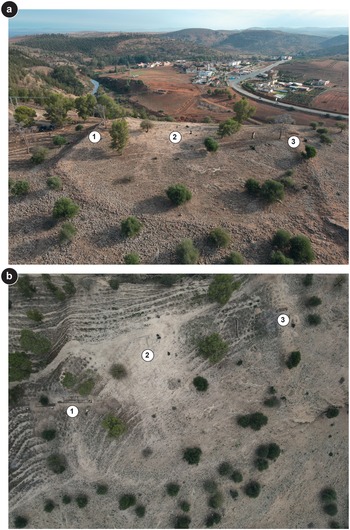

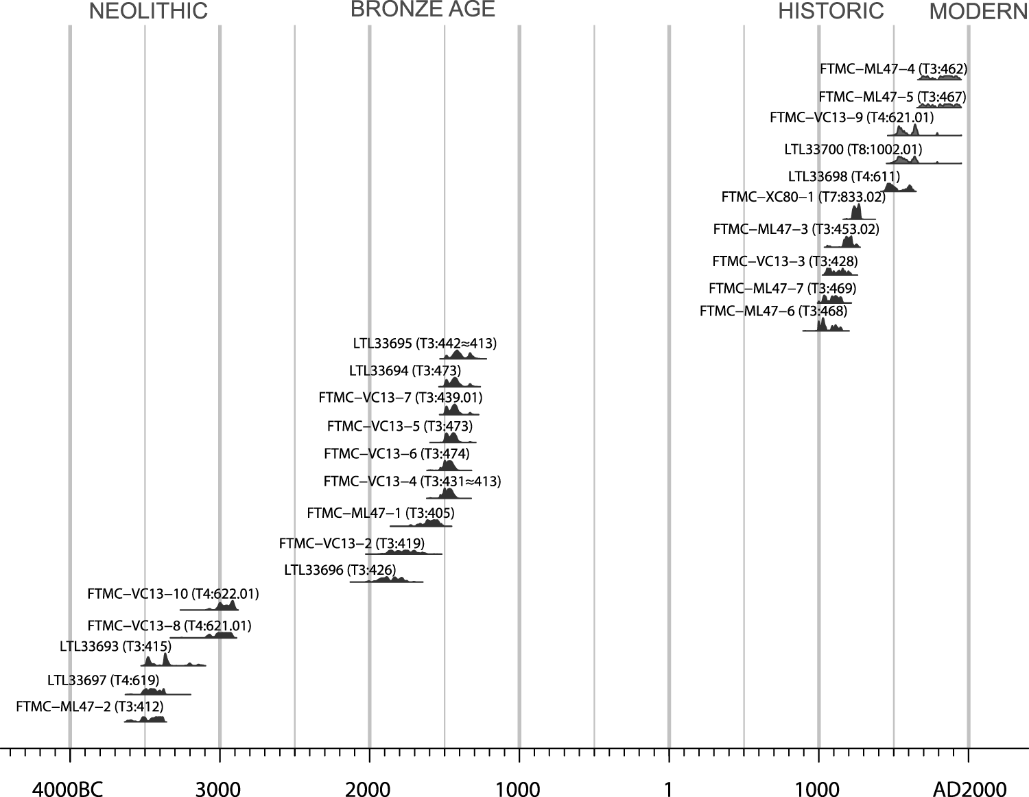

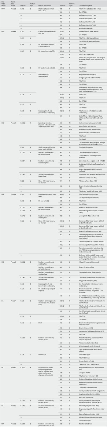
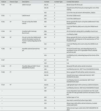
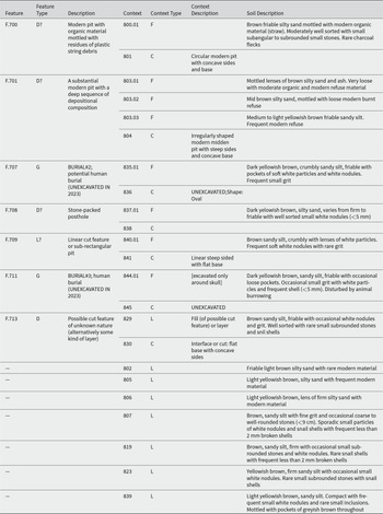
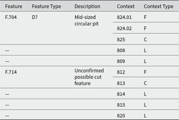


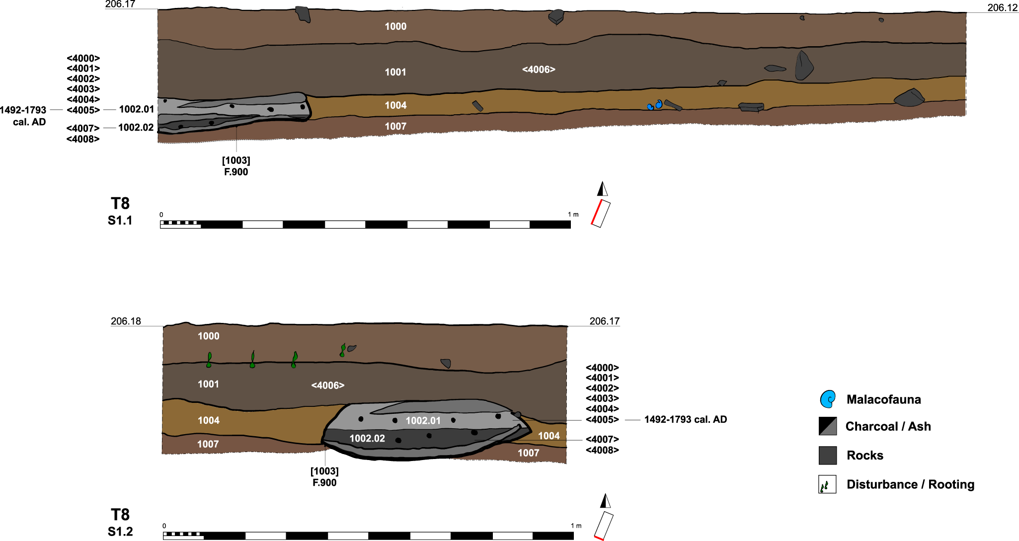


 Open access

