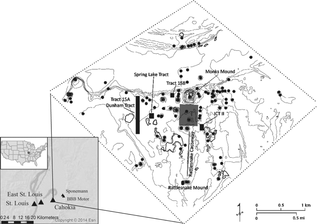
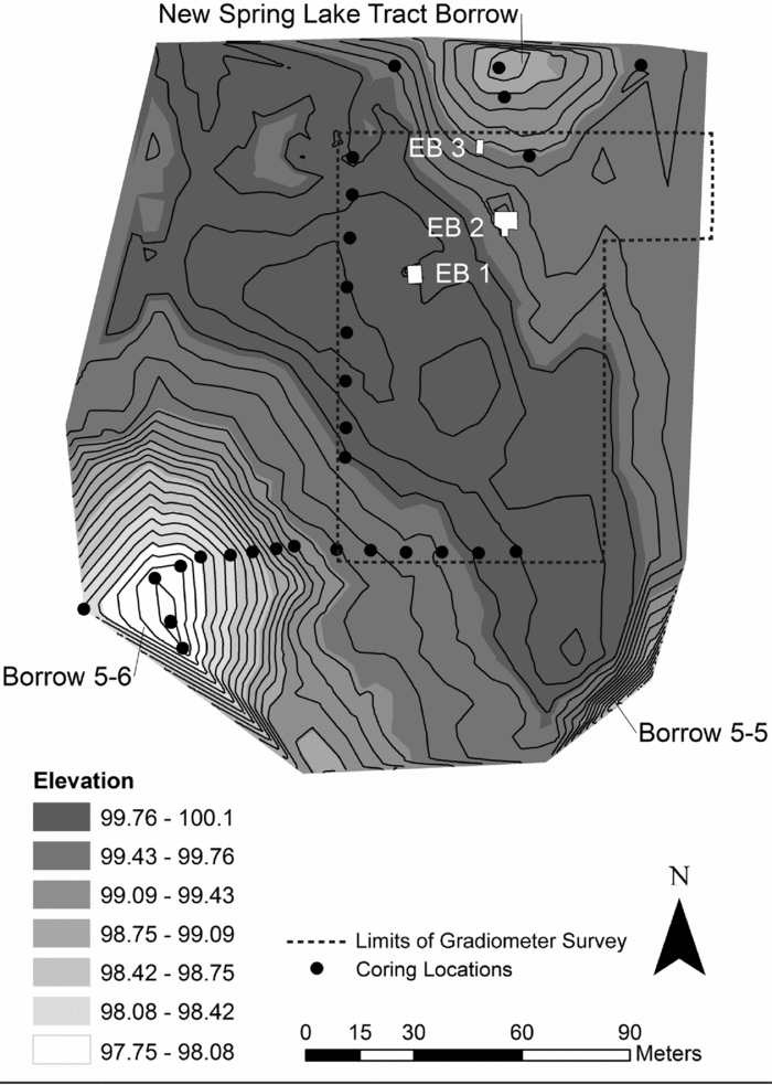
Cahokia Mounds, Native North America's largest urban center north of Mexico (see Baires and Baltus Reference Baires and Baltus2016; Kelly and Brown Reference Kelly, Brown, Creekmore III and Fisher2012; Pauketat Reference Pauketat2004; Pauketat et al. Reference Pauketat, Fortier, Alt and Emerson2013), is the focus of the following study (Figure 1). We present the results of our magnetometry survey and subsequent ground-truthing from the 2015 and 2016 field seasons at the Spring Lake Tract, a newly defined ritual-residential area with occupation spanning AD 1050–1300 (the Lohmann to Moorehead phases). The Spring Lake Tract (Figure 2) is flanked to the southwest and southeast by two large borrow pits (Borrow Pits 5–5 and 5–6; Fowler Reference Fowler2003:223); to the north by a small platform mound (Mound 75; Fowler Reference Fowler2003:221) and Tract 15A, a mixed public and residential area; and to the west by the Dunham Tract, another residential space (Pauketat Reference Pauketat1998). During its occupation, the Spring Lake Tract would have been within view of both Woodhenge and Monks Mound, situated on the periphery of “downtown Cahokia” (Figure 1; Helmer and Mesmer Reference Helmer and Mesmer2016). Our primary research goal was to identify the temporal affiliation and nature of occupation of the Spring Lake Tract to investigate the changes to neighborhood space and understand urban land use during Cahokia's existence. An initial magnetometry survey allowed us to examine site layout and density of occupation, and targeted excavation of three magnetic anomalies. We hypothesized that these anomalies (Figure 3) would provide data on (1) temporal affiliation of the Spring Lake Tract, (2) building type (e.g., residential or special-use), (3) intrasite or neighborhood organization, and (4) site use over time.
American Bottom region and Cahokia Site with locations of excavated tracts (adapted from Pauketat et al. 2015: Figure 3.7, permission from Molly O'Halloran).

Topographic map of Spring Lake Tract at 0.5 m interval, excavation blocks (EB 1, 2, 3), and soil core locations (designated by black circles).

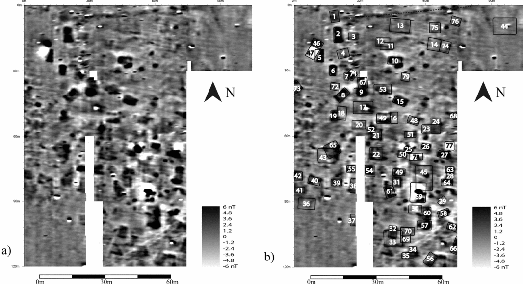
Spring Lake Tract (a) gradiometer survey results and (b) magnetic anomalies identified as structure features. Anomalies 8 and 10 tested during 2016 excavations; dashed line represents southern limit of Spring Lake Tract borrow.

We report on the analysis of the magnetometer data and subsequent test excavations, and summarize the preliminary results from the geomorphological analyses of 31 soil cores taken across the survey area. Combining these data, we identify possible features at the Spring Lake Tract using the geophysical results to discuss structure density, intrasite settlement organization, and relationship to the urban organization of Cahokia. These new data develop our understanding of Cahokia's use and construction of place through minimally invasive means. We suggest possibilities for extrapolating geophysical data to understand archaeological feature distribution and temporal affiliation on a densely occupied urban landscape. Our data indicate that this particular area of Cahokia was occupied from the Terminal Late Woodland (TLW) through Moorehead phases, but with a surge in structure building and use during the Moorehead phase. Our results contradict general conclusions of a population decline during the Moorehead phase (Pauketat Reference Pauketat1998, Reference Pauketat2013; Pauketat and Lopinot Reference Pauketat, Lopinot, Pauketat and Emerson1997), indicating instead that new structures were added to the landscape of the Spring Lake Tract during that time.
The Spring Lake Tract Geophysical Survey
We began this project in the summer of 2015 with a magnetometry survey conducted by Watts Malouchos, using a Bartington Grad 601 Dual Fluxgate Gradiometer. Prior to the start of survey, we worked with Dr. Mark Esarey (Illinois Historic Preservation Agency Site Manager) and a tenant farmer to mow the targeted area, which is covered with tall grass for hay production. We laid out a series of nine 30×30 m survey grids with four adjacent 30×15 m survey grids to most effectively cover the cleared area for a total area of 9,900 m2. The surveyor walked the grids in a zigzag pattern, with readings collected along 0.5 m traverses at 0.125 m intervals.
We downloaded and processed the gradiometer data in TerraSurveyor. Data-processing is a frequentative and cumulative effort; these raw data were ultimately processed using the following limited sequence: (1) clipping of the data to +/- 6 nanoteslas (Nt) to avoid distortion of anomaly size, (2) zero mean sensor destriping, and (3) interpolation along the x-axis. The results show a range of numerous magnetic anomalies, the majority of which we inferred to be buried archaeological features in a densely inhabited area of the site (Figure 3).
Interpreting the Gradiometer Results
Our interpretation of the gradiometer results prioritized identifying magnetic anomalies that represented residential or public structures (Figure 3). While we do recognize variability in magnetic signatures of possible features between the Midwest and Southeast, we draw from the proliferation of magnetometry studies across both regions here, narrowing our comparison to the Midwest in our discussion (see below). There are generally accepted criteria for identifying archaeological features from gradiometer results (see Barrier and Horsley Reference Barrier and Horsley2014; Betzenhauser Reference Betzenhauser2011; Buchanan Reference Buchanan2015; Davis et al. Reference Davis, Walker and Blitz2015; Hargrave Reference Hargrave and Johnson2006; Horsley et al. Reference Horsley, Wright and Barrier2014). Rectilinear anomalies typically represent structure basins or larger nondomestic buildings (while potentially obscuring interior features); smaller circular anomalies (depending on size and magnetic amplitude) may represent circular buildings, hearths, pit features, posts, or monumental post features. Areas devoid of strong magnetic signals may suggest minimal human activity, uninhabited areas, or human activities that left no detectable geomagnetic alterations (e.g., courtyards and plazas; see Barrier and Horsley Reference Barrier and Horsley2014; Davis Reference Davis2014).
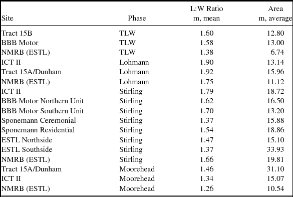
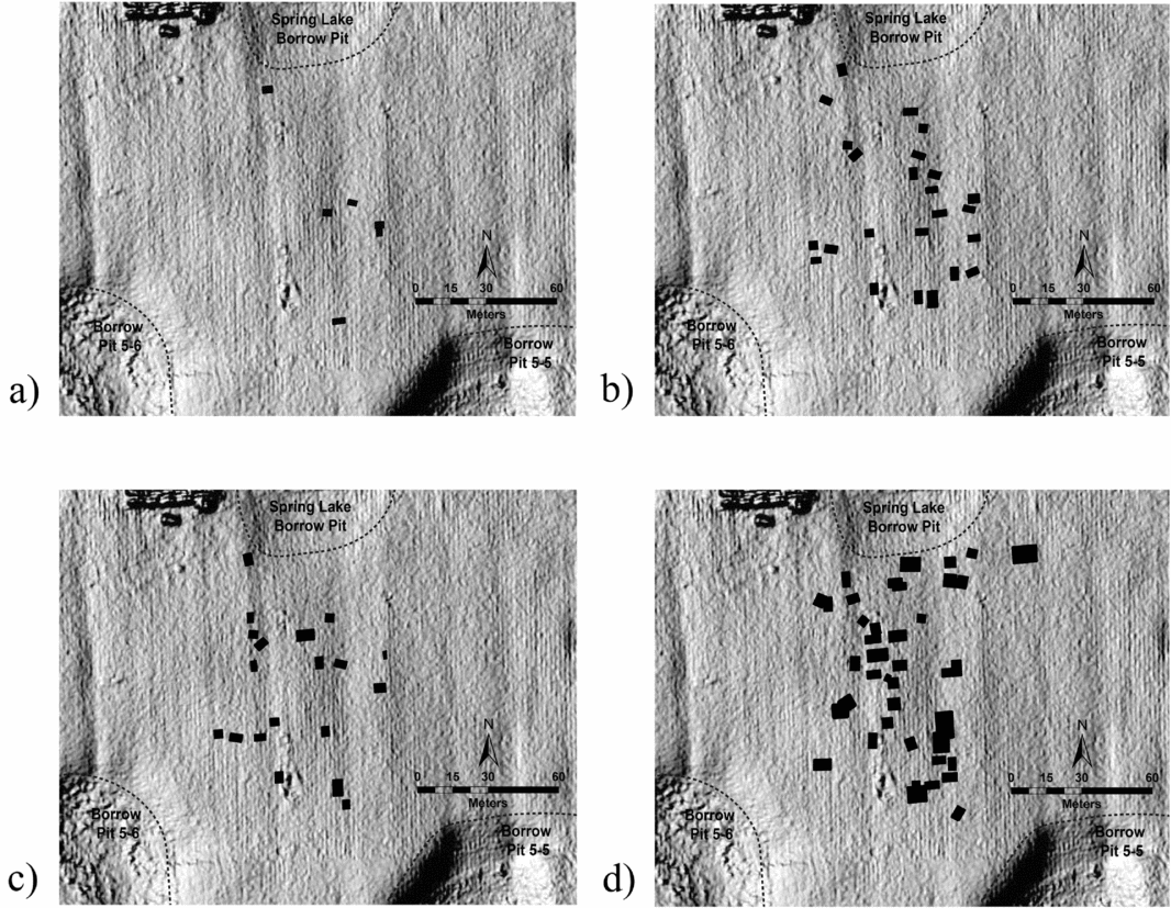
Extant data concerning residential and community architecture from geophysical surveys and excavations in other tracts at Cahokia as well as other Mississippian mound centers and sites in the region informed our expectations of residential structures as large (> 4 m2), rectilinear anomalies, often with moderate to high magnetic amplitude (e.g., Betzenhauser Reference Betzenhauser2011; Hargrave Reference Hargrave2011). While circular anomalies that represent storage/refuse pits and circular buildings are present in the results, we focused on identifying rectilinear anomalies as possible structures, as they are generally attributable to TLW and Mississippian temporal phases based on size, shape, and structure orientation (following Barrier and Horsley Reference Barrier and Horsley2014; Betzenhauser Reference Betzenhauser2011; Davis et al. Reference Davis, Walker and Blitz2015; Hargrave Reference Hargrave and Johnson2006). Our comparative data are derived from contexts located within the site boundaries of Cahokia Mounds, the East Saint Louis (ESTL) precinct, and sites immediately surrounding Cahokia that are arguably part of the urban center (see Fortier et al. Reference Fortier, Emerson and McElrath2006). These sites include Interpretive Center Tract (ICT) II (Collins Reference Collins1990), Tract 15A/Dunham Tract (Pauketat Reference Pauketat1998), Tract 15B (Pauketat Reference Pauketat2013), BBB Motor (Emerson and Jackson Reference Emerson and Jackson1984), Sponemann (Fortier et al. Reference Fortier, Maher and Williams1991; Jackson et al. Reference Jackson, Fortier and Williams1992), ESTL, Northside and Southside excavations (Fortier Reference Fortier2007; Pauketat Reference Pauketat2005), and the ESTL Mississippi River Bridge (NMRB) (Brennan et al. Reference Brennan, Betzenhauser, Lansdell, Plocher, Potter, Blodgett, Emerson, Koldehoff and Brennan2017; see Figures 1, 2). We intentionally excluded sites that are not likely part of the Cahokian urban area to avoid introducing additional variability related to social or functional differences of rural floodplain or upland locales. Using measurements of 826 rectangular structures from eight excavations, we calculated averages for length and width ratios (m) and structure area (m2) by temporal phase. These data were then compared to our estimated measurements of the Spring Lake Tract rectangular structures identified on the gradiometer map to hypothesize possible chronological affiliation of Spring Lake Tract buildings (Table 1; Figure 4).
Length:Width Ratio and Structure Area Averages by Site and Temporal Phase.

Note: Data compiled from Brennen et al. Reference Brennan, Betzenhauser, Lansdell, Plocher, Potter, Blodgett, Emerson, Koldehoff and Brennan2017; Collins Reference Collins1990; Emerson and Jackson Reference Emerson and Jackson1984; Fortier ed. Reference Fortier2007; Fortier et al. Reference Fortier, Maher and Williams1991; Jackson et al. Reference Jackson, Fortier and Williams1992; Pauketat Reference Pauketat1998, Reference Pauketat2005, Reference Pauketat2013.
Spring Lake Tract structures by chronological phase: (a) Terminal Late Woodland, (b) Lohmann, (c) Stirling, (d) Moorehead.

Interior floor area and the length-to-width ratios of rectilinear structures are commonly used to discuss size and shape trajectories of buildings at TLW and Mississippian sites in the American Bottom region (e.g., Collins Reference Collins1990; Emerson and Jackson Reference Emerson and Jackson1984; Fortier et al. Reference Fortier, Maher and Williams1991; Pauketat Reference Pauketat1998, Reference Pauketat2013). A length-to-width ratio closer to 1 indicates that the building is more square than rectangular; buildings at and around Cahokia are typically closer to a square during the TLW, becoming rectangular during the Early Mississippian Lohmann and Stirling phases, and return to square during the Moorehead phase (Collins Reference Collins1990; Emerson Reference Emerson1997; Porter Reference Porter1974). TLW rectilinear structures are much smaller than their Lohmann and Stirling counterparts, with Late Stirling and Moorehead buildings typically larger in size (Collins Reference Collins1990; Emerson Reference Emerson1997; Mehrer Reference Mehrer1995). We determined average structure area by site and phase for each Cahokia locale included in the analysis, intentionally removing structures with floor areas < 10 m2 because they likely represent storage structures (Pauketat et al. Reference Pauketat, Fortier, Alt and Emerson2013). We included most structures with floor areas ≥ 10 m2 (see discussion of cluster analysis below), as these measurements typically represent domestic and/or public buildings.
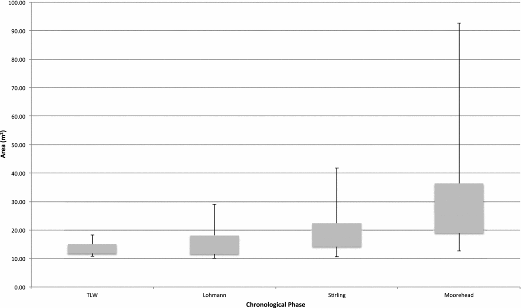
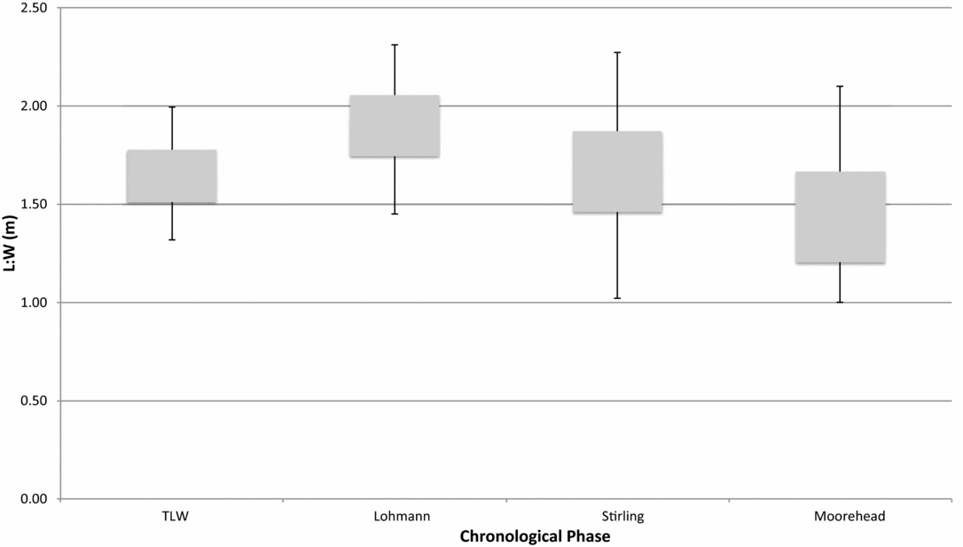
Figures 5 and 6 demonstrate the trends in length:width (L:W) ratios and floor area for the comparative floodplain sites. Floor area increases over time with the smallest structures in the TLW and the largest in the Moorehead phase. Additionally, L:W ratios demonstrate the trends in building shape from the TLW phase, through the Lohmann and Stirling phases and into the Moorehead phase. These trends parallel those found through previous excavations in the region (e.g., Baltus Reference Baltus2014; Betzenhauser Reference Betzenhauser2011; Collins Reference Collins1990; Mehrer Reference Mehrer1995; Pauketat Reference Pauketat2013).
Average structure area by chronological phase (data compiled from Brennan et al. Reference Brennan, Betzenhauser, Lansdell, Plocher, Potter, Blodgett, Emerson, Koldehoff and Brennan2017; Collins Reference Collins1990; Emerson and Jackson Reference Emerson and Jackson1984; Fortier Reference Fortier2007; Fortier et al. Reference Fortier, Maher and Williams1991; Jackson et al. Reference Jackson, Fortier and Williams1992; Pauketat Reference Pauketat1998, Reference Pauketat2005, Reference Pauketat2013).

Average structure length-to-width ratio by chronological phase (data compiled from Brennan et al. Reference Brennan, Betzenhauser, Lansdell, Plocher, Potter, Blodgett, Emerson, Koldehoff and Brennan2017; Collins Reference Collins1990; Emerson and Jackson Reference Emerson and Jackson1984; Fortier Reference Fortier2007; Fortier et al. Reference Fortier, Maher and Williams1991; Jackson et al. Reference Jackson, Fortier and Williams1992; Pauketat Reference Pauketat1998, Reference Pauketat2005, Reference Pauketat2013).

In total, we identified 79 potential rectilinear structures on the Spring Lake Tract magnetometry survey, 77 of which had floor areas ≥ 10 m2 (see Figure 3). We did not include pit features or circular structures in our analyses, as they cannot be easily divided into temporal affiliation based on size alone. We identified structures based on magnetic signature (both dipolar and monopolar anomalies), rectilinear shape, and comparatively large size. Our feature identifications are conservative, as issues of equifinality and the palimpsest effect are particularly salient at Cahokia, a city occupied for hundreds of years (see Davis et al. Reference Davis, Walker and Blitz2015; Hargrave Reference Hargrave and Johnson2006; Peterson Reference Peterson2010). As our excavations demonstrate, there is a tendency for features that are burned or features that include large quantities of organic material to mask the magnetically weaker signal of surrounding and superimposing features. Moreover, complex superpositioning of features, which is common at Cahokia, may cause anomalies to appear larger in magnetic data.
Using our Spring Lake Tract gradiometer data, we tested the utility of geophysical data to identify structures, hypothesize temporal affiliation, and explore changes in site organization over time. First, we explored whether the observed correspondence between temporal affiliation and building size/shape trends among Cahokian structures had statistical validity by running a k-means cluster analysis with SPSS, using as variables the area and L:W ratios of structures listed in Table 1. The areas of structures were converted to logarithmic values in order to bring their scale closer to that of the L:W ratios; without this conversion, the clusters were skewed, with greater weight placed on the area values. Three outliers were also discarded from these samples: two Moorehead phase buildings from the ESTL Northside excavations, due to their size, and one Lohmann phase building from Tract 15A, due to its rather large L:W ratio (> 3).
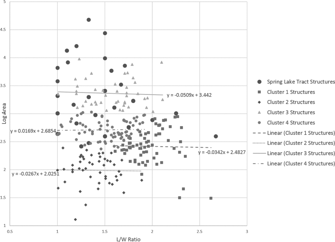
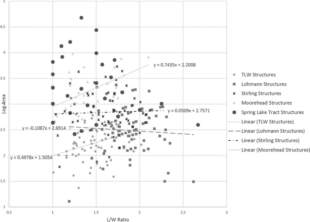
The four clusters produced by SPSS did not coincide precisely with the temporal assignments reported by researchers for each structure; however, spatially plotted, Cluster 2 is affiliated with TLW structures, Cluster 1 with Lohmann structures, Cluster 4 with Stirling structures, and Cluster 3 with Moorehead structures (Figure 7). There was a considerable amount of overlap between reported temporal affiliation in terms of building size and shape not captured by the cluster analysis. This overlap likely reflects the continuity of the data, the variability in how Cahokian structures changed over time, and social and functional differences in buildings across the city. Using a t-test, we compared means of area and L:W ratios between clusters assigned by SPSS and those according to reported temporal affiliation; there was no statistically significant difference among three of the four clusters. The mean area and L:W ratios of Lohmann phase buildings were significantly different than those of its closest affiliated cluster, Cluster 1 (p = 0.0263); p-values for all other temporally affiliated structures and cluster assignments were greater than 0.05, suggesting similarities between clusters assigned by SPSS and those according to reported temporal affiliation.
Regressions of clusters with Spring Lake Tract structures.

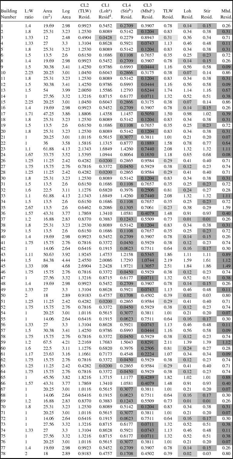
To hypothesize the temporal affiliations of the Spring Lake Tract structures, we compared their proximity to the SPSS-generated clusters and their proximity to clusters according to reported temporal affiliation. This proximity was calculated using the regression equations for each cluster, the residuals of which are reported in Table 2. The lower the residual, the more likely the building corresponds to a cluster. In many cases, the residuals agree, assigning a Spring Lake Tract building to the same phase based on both SPSS-generated cluster and reported affiliation cluster; in general, the reported temporal affiliations provide a closer fit. These analyses allow us to hypothesize the temporal affiliation of most of the Spring Lake Tract structures (see Table 2; Figures 7, 8).
CABB Structure Phase Assignments by Residuals.

Note: Structure numbers 7, 25, 29, and 53 unassigned due to small size (< 10 m2). (a) Lohmann, (b) Stirling, (c) Moorehead, (d) residual. Shading represents temporal assignment based on low residuals; lightest shading represents TLW grading to the darkest shading representing Moorehead phase. Some structures may align with more than one phase.
Regressions of temporal affiliations of all structures.

Based on the regression equations of temporally assigned building clusters, the Spring Lake Tract buildings represent the entire occupation history of Cahokia. Six buildings are potentially TLW, 13 potentially date to the Lohmann phase, 12 could be assigned to either the Lohmann or the Stirling phase, 5 are likely Stirling phase, and 30 are potentially affiliated with the Moorehead phase, a significant number of buildings that differentiates the Spring Lake Tract from nearby excavated Tracts like ICT-II and the Merrell and Tract15A/Dunham Tracts.
The seven Spring Lake Tract buildings with areas > 50 m2 are likely nondomestic structures, making a temporal affiliation more difficult. Using the regression equation of SPSS-assigned clusters, we identified no TLW buildings among the Spring Lake Tract structures, and only 5 buildings are potentially Lohmann phase; 34 may be Stirling phase structures, and 28 are potentially Moorehead phase buildings. Comparing these temporal patterns to other nearby Cahokia locales such as ICT-II and Tract 15A/Dunham tract, we see similarities in the low number of TLW buildings, and an increase in the Lohmann and into the Stirling phase (see Collins Reference Collins1990; Pauketat Reference Pauketat1998). What differs at the Spring Lake Tract is the high number of potential Moorehead phase buildings. These temporal affiliations are strictly hypothetical and based on size and shape estimates inferred from the geophysical data. We further categorized the structures by observed (but not strictly adhered to) archaeologically identified architectural trends. We do recognize that strongly positive and high-contrast anomalies may appear larger in the resulting image, and that lower-contrast anomalies may appear smaller than they actually are. Ground-truthing is, of course, necessary to corroborate structure size and temporal affiliations generated through cluster analysis, and continued excavations will provide data concerning inferred size versus excavation-derived architectural data.
Site layout over time can also be estimated from the gradiometer data using the structure L:W ratios and floor areas. In addition to calculating structure size, we identified orientation of the rectilinear anomalies to compare to previously observed trends at Cahokia. While cardinally oriented structures are common in the geophysical results, we identified two courtyard arrangements of buildings. Courtyard groups characterize the TLW phase with possible return to that organization in the Stirling phase (Collins Reference Collins1990; Kelly Reference Kelly and Smith1990; Pauketat and Lopinot Reference Pauketat, Lopinot, Pauketat and Emerson1997). Based on structure size and shape (e.g., L:W ratio, floor area) and our excavation of one of these structures (Feature 6, EB 1), the central courtyard group likely dates to the Stirling phase. This area was then reclaimed during the Late Stirling phase as exemplified by the construction of the cardinally oriented Feature 4. The southeastern courtyard group consisted of small rectilinear structures and, based on L:W ratio and floor area, likely fit within the TLW phase. The presence of these two temporally distinct courtyard groups and the identification of rectilinear structures that correspond to the Moorehead phase indicate that the Spring Lake Tract was populated from the TLW through the Moorehead phase. As mentioned above, most of the identified structures fall within the ranges of Stirling and particularly of the Moorehead phases.
Ground-Truthing Anomalies through Geomorphology and Excavation
Based on our initial interpretation of the gradiometer results, we selected three anomalies for test excavations during the 2016 field season. Testing anomalies with an Oakfield soil probe, a common method of ground-truthing gradiometry results, is not applicable due to a 30 cm deep double plow zone and the clay-rich loam soils that, when dry, make probing even freshly exposed feature fill difficult. In addition to excavating these three features, we also extracted a series of soil cores to corroborate the presence of anomalies by examining the soil for evidence of anthropogenic use.
Geomorphology
Michael Kolb and Andy Jalbert of Strata Morph Geoexploration, Inc. extracted 31 soil core samples using a truck-mounted hydraulic coring machine. Kolb (Reference Kolb2016) made the preliminary interpretations of soil composition and deposition. Kolb and Jalbert extracted samples across the southern, western, and northern boundaries of our magnetometer grid, as well as in a cruciform pattern across Borrow Pit 5–6 (Figure 2). Our focus for the geomorphology coring was to target Borrow Pit 5–6 and the magnetically “quiet” area in the southwest part of our survey area, and to sample areas of the geophysical data that yielded strong magnetic anomalies.
The soil cores along the southern limits of our surveyed area and west of Borrow Pit 5–6 tested the area defined by a magnetically quiet signature. A general lack of anthropogenically enhanced soils and of distinct magnetic anomalies suggests that this area was not residential and was maintained as an open place. Our preliminary conclusions indicate that this was a plaza space, though not one built up like the nearby Grand Plaza (see Alt et al. Reference Alt, Kruchten and Pauketat2010; Dalan et al. Reference Dalan, Holley, Woods, Watters and Koepke2003).
In comparison to the magnetically quiet plaza space, eight cores were extracted from south to north across the area where distinctive magnetic anomalies were present. Areas of anthropogenically enhanced soils recovered in the cores correspond to areas of magnetic anomalies, further supporting the likelihood that magnetic anomalies are indicative of subsurface features rather than modern disturbances or differences in natural soil composition. This serves to reinforce the likelihood that magnetically quiet areas are indeed devoid of features, further supporting our hypothesis that the southwest portion of the magnetometry survey grid corresponds to an open area like a plaza. As visible on the topographic map shown in Figure 2, there may be a ramp from the possible plaza into the borrow pit.
Kolb and Jalbert identified upper, middle, and lower soil formation sequences in the cores recovered from inside Borrow Pit 5–6, corresponding to post-borrowing activities. The upper sequence consists of alluvium deposited during historic times. The middle sequence consists of laminated clays from rain events and intermittent low-magnitude flooding. Only one core produced charcoal in the lower 50 cm; the remaining cores were devoid of cultural material, suggesting that Borrow 5–6 was intentionally kept clean. In addition, no evidence suggests that the borrow pit was filled with water for any extended period.
Excavations of Anomalies
Features targeted for excavation were selected from the gradiometer map based on strength of magnetic signal, anomaly shape and size, and location of anomaly in relation to other identified features; we selected three features from the gradiometer data for testing. Using a total station and grid coordinates from our gradiometer survey, we aligned our excavation blocks (EBs) according to the likely location of the features of interest. A total of three EBs were opened by hand, removing the plow zone from approximately 64.5 m2 and excavating approximately 22 m2 of feature fill (see Figure 2). Our excavations targeted the following inferred features to address our research question concerning the change in landscape use over time: (1) a rectilinear semisubterranean residential building aligned to a courtyard group (EB 1); (2) a rectilinear semisubterranean isolated (potentially extra-domestic) structure (EB 2); and (3) a large linear anomaly extending east-west along the northern boundary of the mag survey, which turned out to be an indigenously reclaimed borrow pit (EB 3). In the following, we present the results of our excavations, focusing on structure size and shape, infilling processes (as they may inform magnetic signatures), and associated diagnostic artifacts used to establish chronology (Holley Reference Holley1989; O'Brien Reference O'Brien1972; Pauketat Reference Pauketat1998, Reference Pauketat2013; Vogel Reference Vogel1964, Reference Vogel and Brown1975).
Excavation Block 1
An approximately 4×5 m area opened by hand, EB 1 revealed a densely packed series of superimposed features. These features included wall trenches and basin fill likely affiliated with at least three, possibly four, individual structures, posts, refuse pits, burned deposits, and other fill features not clearly visible in the magnetometer data. Intending to ground-truth the structure identified as part of a courtyard group of likely domestic structures (Figure 3), we focused on the area of the EB that corresponded to the targeted feature. We made two bisections across a cardinally oriented wall trench and affiliated basin fill (designated Feature 4) located in the northeastern portion of the EB.
Excavations along these bisect lines revealed an upper structure (Feature 4) that superimposed an earlier building (Feature 6). We revealed a portion of the northern wall trench of the earlier and courtyard-oriented Feature 6 in our excavations. Feature 6 had a deep basin (40 cm); after abandonment, the building became packed with homogeneous gray clay containing very little artifactual material. This infilled basin was revisited aboriginally, reexcavated along the north wall, and a reed or grass mat wrapped around small poles (akin to a litter, although no human remains were present) was placed into this reexcavation. This mat or litter was then burned in place, as indicated by oxidation of the soils adjacent to and below this material, followed by a filling-in of the reexcavated area. A Ramey Incised sherd was located directly beneath this burned matting.
Feature 4, the cardinally oriented wall-trench structure with shallow basin (approximately 28 cm), was constructed over the location of Feature 6. The western wall trench of Feature 4 and posts cut through the burned material in the reexcavated and lined portion of Feature 6. It is likely that the burned material in the reexcavation, along with the deep basin of Feature 6, created the strong anomaly noted in the magnetometer survey; the high amplitude of this anomaly likely masked the quieter signature of the superimposing Feature 4.
Excavation Block 2
EB 2 was an approximately 4×6 m area opened by hand to expose a rectangular structure basin (Feature 2), with two additional (nonrelated) feature stains extending outwards to the south and east. We bisected the large basin, excavating the western half to the floor of the building. Feature 2 was rebuilt at least three times as demonstrated by a series of overlapping wall trenches with visible posts; one line of posts was visible at the base of the plow zone, suggesting that the infilling of this building began while the final wall posts were still standing. The termination of this large building included lining the floor and edges of the basin with homogeneous gray clay. Basket loads of charcoal and burned clay were deposited on top of the gray clay layer—mostly in the southern section of the western half excavated—followed by large amounts of deer bone and large pottery sherds deposited together within the remainder of the basin.
Based on the gradiometer results, Feature 2 appears to be relatively isolated from other similarly large buildings or smaller domestic structures. However, three small rectilinear-shaped anomalies are located immediately to the south and east of this structure and may have been associated with this large building. From the size of the structure to the material deposited in the fill, Feature 2 is not a typical domicile. We suggest that Feature 2 was a public structure, or, at the very least, extra-domestic, terminated during the Late Stirling phase based on the presence of Ramey Incised jar fragments that demonstrate a more globular shoulder shape (Baltus Reference Baltus2014; Holley Reference Holley1989).
Excavation Block 3
EB 3 is located north and west of EB 2, placed to explore a linear feature at the northern end of the survey area. EB 3 is approximately 2×4 m, oriented north-south. At the base of the plow zone, excavations revealed a line of feature fill extending to the north. This fill continued in a steep slope to the north and included layered zones of light and dark soils, as well as prepared fills of mixed yellow clay and dark gray silt. It was identified as a reclaimed borrow pit. Kolb and Jalbert's coring confirmed this feature and showed anthropogenic soils to a depth of approximately 2.75 m.
Our ca. 75 cm of excavations in EB 3 show the infilling process in this new Spring Lake Tract borrow clearly. The sloping ramp into the borrow had redoximorphic features along the edge, suggesting that it held water periodically. A rich organic fill with a density of charcoal was deposited along the slope of this ramp and descended into the borrow. This fill zone contained the most material, including stacked collections of large vessel sherds, large pieces of limestone, projectile points, copper, and quartz crystal. Among the vessels was a large portion of an Early Stirling jar. Above this artifact- and organic-rich zone was a series of packed sterile zones, as described above. Periodically, small reexcavations were made into the fills of the borrow pit, into which stacks of sherds were deposited.
The northern extent of our magnetometry survey area was truncated due to wet conditions during the 2015 field season; additionally, the presence of a large (modern) backdirt pile also restricted our geophysical survey area. Given these limitations, the reclaimed Spring Lake Tract borrow pit was visible in the gradiometer results, but only as a linear anomaly along the northern section of the area surveyed. The linearity of this anomaly led us to initially interpret this as a possible compound wall similar to those constructed at Tract 15A (see Pauketat Reference Pauketat1998). Our excavations disproved this hypothesis and, when combined with our topographic map and the geomorphological soil analysis, confirmed an infilled borrow pit extending to the north (see Figure 2).
Discussion
We turn now to Tracts 15A/Dunham Tract, Tract 15B, and the ICT-II (Figure 1) to discuss temporal changes to these neighborhoods in comparison to our Spring Lake Tract magnetometry and excavation results. Tract 15A is located directly northwest of the Spring Lake Tract and the Dunham Tract directly west. Excavated in the 1960s, the occupation of these tracts shifted dramatically over the life of the city, as described by Pauketat (Reference Pauketat1998). Evidence for early TLW (Pauketat's [Reference Pauketat1998:74] EM 1) occupation in the excavated portion of these tracts is low (one structure and one pit); however, the population grew during the latter part of the TLW (10 buildings and 39 pits during Pauketat's [Reference Pauketat1998:74] EM 2 and 16 buildings and 18 pits during the EM 3 [Pauketat Reference Pauketat1998:74, 83]). Buildings are small during the TLW, built in single-post construction style and arranged around courtyards that comprise the main social organizational unit. The TLW occupation appears restricted to the northern Tract 15A, although the Dunham Tract was not excavated in its entirety. The most intensive occupation of Tract 15A/Dunham Tract occurs during the Lohmann phase, with a dramatic increase in the number of buildings (n = 92) and subterranean pits (n = 97), as well as a concomitant reorganization of buildings to a roughly 10–15° orientation placed around plazas rather than courtyards (Pauketat Reference Pauketat1998). The majority of structures are built with wall-trench construction, and circular, L-, and T-shaped buildings make their first appearance on Tract 15A/Dunham Tract during the Lohmann phase. Differences in building sizes seem to correspond to location: larger rectangular buildings are located north of the plaza area, along with circular buildings, while smaller rectangular buildings are located south of the plaza (Pauketat Reference Pauketat1998).
Pauketat (Reference Pauketat1998) reports a co-optation of Tract 15A for public-ritual use during the Stirling phase, with the initial construction and subsequent reconstruction of the Post Circle Monument (or Woodhenge). Stirling-phase residential use continues to the south in the Dunham Tract, though not as intensively as the previous Lohmann phase. The few Stirling phase structures located in Tract 15A (n = 4) are likely related to activities associated with Woodhenge, including two large presumably extra-domestic buildings. Following the discontinuation of Woodhenge at the end of the Stirling phase, residential occupation of Tract 15A resumes. Only 16 buildings are confidently assigned to the Moorehead phase. These buildings are larger, some more square and grouped together in apparent household clusters consisting of differently sized buildings (Pauketat Reference Pauketat1998). Buildings are possibly arranged around a large courtyard and potentially oriented to Mound 44, having roughly cardinal orientations.
Tract 15B, also excavated in the 1960s (Pauketat Reference Pauketat2013), demonstrates a similar organization during the TLW as Tract 15A, although with a greater number of buildings (n = 65), most of which date to the Merrell phase (ca. AD 950–1000). These buildings are rectangular single-post structures that, while small, are larger on average than TLW buildings at other sites and in other areas of Cahokia. Like Tract 15A, the TLW buildings in Tract 15B are organized in courtyards with central pits; many buildings are rebuilt in place, indicating an importance of location potentially tied to family or group identity. Early Mississippian (Lohmann and Stirling phase) occupation of Tract 15B encompasses large nondomestic structures and monumental buildings; we know of no small rectilinear domestic structures from this phase on this tract. During the Lohmann phase, a small circular building (probable sweatlodge), a possible mound, and two large rotundas built sequentially occupied this tract. The latter of the rotundas was dismantled by the Early Stirling phase and replaced by a sequence of large compounds with bastioned curtain walls. Enclosed within the last two compounds (B and C) are large structures (including an L-shaped building) and a series of monumental marker posts. These compounds were deconstructed during the Late Stirling or Early Moorehead phase and replaced with a series of ordinary and oversized buildings.
The two ordinary-sized buildings include one constructed over a former monumental post pit; the second had an L-shape and an interior enclosed room, suggesting neither structure was a typical domestic domicile. Two sets of oversized structures were also built in sequence during the Late Stirling/Early Moorehead; one set was superimposed by Late Moorehead or Sand Prairie buildings and burials, while the second set, including one of the largest roofed buildings at Cahokia, was built over the former location of Compound A. Tract 15B experienced a reoccupation during the Mid-Moorehead through Sand Prairie phases as residential space. A total of 48 buildings and 67 pits date to these phases. These buildings are organized in about 15 clusters of one to two buildings and built over the former locations of the public and monumental structures. Building orientations include near-cardinal directions in the earlier part of the Moorehead phase, becoming more strongly oriented northeast-southwest during the Late Moorehead into Sand Prairie, and return to near cardinal with the last Sand Prairie phase buildings (Pauketat Reference Pauketat2013).
Excavations at the ICT-II revealed a neighborhood occupied from the Lohmann through the Moorehead phase (see Collins Reference Collins1990 for full report). ICT-II lacks the TLW occupation notable in both Tracts 15A and 15B. This fairly continuous Mississippian occupation demonstrates the changing household organization over most of Cahokia's historical trajectory in ways that differ from the excavated tracts to the north and west. Specifically, the ICT-II neighborhood remained a residential location throughout the entire sequence, rather than being co-opted for public-ritual use. The Lohmann phase site-wide reorganization is apparent at ICT-II, resulting in a linear arrangement of the tract's 22 structures to the Cahokia Grid. Buildings consisted of both regular domestic structures with wall-trench construction (n = 10), as well as small rectangular buildings (n = 2) with floor areas < 11 m2, a T-shaped building, and a possible L-shaped building. Collins (Reference Collins1990:81) also identified specialized structures (“kitchens,” “ramadas,” “granaries,” and sweatlodges) accounting for eight Lohmann phase buildings.
In the shift from the Lohmann to the Stirling phase, ICT-II buildings increased in size, although they decreased in depth of basin. During the Early Stirling at the ICT-II, many wall-trench structures were rebuilt in the same location. Some structures continued to be oriented to the cardinal directions, while many of the 33 total buildings were aligned to different orientations. Collins identifies multiple building clusters of two to five buildings, located around an open plaza-like area. These clusters contained both regular domicile-sized buildings (n = 18) as well as the small rectangular buildings (n = 9) that appear to be associated with other structures in a household cluster. Two square buildings, an L-shaped structure, and at least one sweatlodge were identified, along with an unusually shaped wall-trench structure and a “kitchen” or “ramada” (Collins Reference Collins1990:81–82).
The Late Stirling structures tended to be larger, some still oriented approximately cardinal (especially on the east side of the plaza area), while others reference other community features. Most of the 14 structures continued to be part of household clusters or building pairs. Twelve rectangular wall-trench structures were identified as Late Stirling buildings; no buildings < 11 m2 were present in the ICT-II after the Early Stirling. A single arbor and a single ramada were part of the Late Stirling occupation. Three rectangular buildings, an arbor, and a granary also fall sometime within the Stirling phase. The occupation of the ICT-II continued into the Moorehead phase with nine square or nearly square buildings arranged in two clusters. These structures were generally larger than the earlier occupations, and reconstructions continued to take place in the exact location or slightly shifted. A single ramada was attached to one of the square buildings. The Moorehead phase buildings tended towards nearly cardinal in their orientation and were present only on the east side of the previous plaza area (Collins Reference Collins1990).
Notably, the high number of structures projected to date to the Moorehead phase makes the Spring Lake Tract unique. While Tracts 15A, 15B, and ICT-II each have evidence for a Moorehead phase occupation, that occupation tends to be smaller than earlier residential use of those areas. Only Tract 15B demonstrates a continued occupation of much significance during the Moorehead and into the Sand Prairie phase, though, arguably, this particular neighborhood was and continued to be recognized as a high-status occupation (see Pauketat Reference Pauketat2013:109–114). Taking into account the caveats noted above regarding degree of error in structure measurements from geophysical data, the Spring Lake Tract holds the potential to provide data on domestic life during the Moorehead phase to serve in comparison to Tract 15B.
This contribution is significant, as it may potentially alter archaeological understandings of the processes of collapse at Cahokia. Perhaps during the Moorehead phase, at certain locales, we may see an increase in domestic structures suggesting a repurposing of space. As Baltus (Reference Baltus2014) has discussed, this could constitute a revitalization of practice in which people did not vacate this city landscape but reorganized domestic space, creating new and potentially smaller neighborhoods outside the central core of Cahokia.
Conclusions
The Spring Lake Tract, situated to the west of Downtown Cahokia, southeast of the ritual/residential neighborhood of Tract 15A and directly east of the Dunham Tract, sits adjacent to two large borrow pits in a relatively flat landscape. Targeting this area through minimally invasive survey and subsequent excavation provides us with new data on neighborhood occupation density and change over time. The geophysical survey of the Spring Lake Tract revealed at least 79 rectilinear anomalies, which, when compared to a vast database of excavated structures from elsewhere at Cahokia, provide a means of hypothesizing temporal affiliation. Based on these data, we were able to hypothesize possible chronological affiliation of Spring Lake Tract structures identified in our gradiometer results. While we recognize that not all of the comparative buildings fall consistently within temporal or SPSS-generated clusters, our analyses indicate that the recognized trends in structure shape and size do have validity in relation to temporal phase. This allows us to assign Spring Lake Tract buildings to Cahokia's accepted chronological phases: Terminal Late Woodland, Lohmann, Stirling, and Moorehead. Based on these suggestions, people occupied the Spring Lake Tract throughout the entire chronological sequence of Cahokia's history with potential for a denser population during the Stirling and Moorehead phases. The presence of a high number of possible Moorehead phase buildings is unique to the Spring Lake Tract and may suggest that this area was more densely occupied during the end of Cahokia's site occupation. These results create testable hypotheses to ground-truth the geophysical data by targeting identified structures.
The temporal affiliation of our excavated structures from EB 1 and 2 roughly correlate with the associated chronological phase derived from the cluster analyses based on both SPSS-generated clusters and temporal affiliation clusters. Feature 6, for example, dates to the Stirling phase based on pottery recovered from the structure basin. Our cluster analysis placed this structure in either the Lohmann or Stirling phases, with a 0.01 difference between the residuals associated with both phases based on temporal affiliation; however, the SPSS-generated cluster places this feature in the Stirling phase. Comparing the results of the chronological phase assignment by residuals with the structure orientation and its location in a courtyard group further supports the hypothesis that this building dates to the Stirling phase, the time when we see a return to courtyard groups at ICT-II at Cahokia. Feature 2, located in the north-central portion of the Spring Lake Tract, was assigned to the Lohmann phase based on our cluster analysis by temporal phase and to the Stirling phase based on SPSS-generated clusters. Based on the proliferation of Ramey Incised pottery, the termination and in-filling of Feature 2 can be confidently dated to the Stirling phase. Due to the evidence for rebuilding of this particular structure (with evidence for three construction episodes), it is possible that this structure was built in the Lohmann phase and decommissioned during the Stirling. Forthcoming AMS dates from features located on the structure floor of Feature 2 will aid in corroborating the assignment of this building to a chronological phase.
Additionally, we examined the organizational layout of anomalies at the Spring Lake Tract to consider trends in urban development over time. It is generally accepted that the advent of Cahokia as a city about AD 1050 (see Pauketat Reference Pauketat1994; Pauketat et al. Reference Pauketat, Fortier, Alt and Emerson2013) was accompanied by a shift in household organization from TLW courtyard arrangements of domiciles to buildings oriented to the Cahokia Grid or a cardinal orientation. In addition to this shift in orientation, structures were built in the wall-trench style, moving away from the posthole method of the TLW phase (Pauketat and Alt Reference Pauketat and Alt2005). At the Spring Lake Tract, we note organizational layouts of rectilinear anomalies according to both cardinal orientation and courtyard groups. Courtyard groups are most prolific during the TLW, replaced by cardinal orientations during the Lohmann phase, with a shift back to courtyard or small plaza organization during the Stirling phase (Collins Reference Collins1990). Cardinal building orientations are noted again during the Moorehead phase (Baltus Reference Baltus2014), coincident with an increase in size and tendency towards square shape. When combining these data, it becomes clear that this area of Cahokia was inhabited consistently from the TLW to the Moorehead phase; we can identify courtyard arrangements of smaller structures (characteristic of the TLW), cardinally oriented buildings in a grid layout (most of which may be Moorehead phase), and another courtyard arrangement of structures that likely correlates to the Stirling phase. Finally, there is an area in the southwest of the Spring Lake Tract that is devoid of anomalies and that, we argue, is a plaza that appears to be maintained throughout the duration of the Spring Lake Tract's use.
Overall, our method of estimating structure size and shape from geophysical anomalies and comparing those data to known structure sizes and temporal affiliation provides a hypothetical but potentially useful means for analyzing gradiometer data prior to excavation. Embedded within this broader research focus was a consideration of the efficacy of magnetometry in identifying buildings in the densely packed landscape of Cahokia, though this method of analysis is applicable to other archaeological sites with strong magnetometry results and a large database of structures with known temporal affiliations. Having an estimated temporal affiliation for anomalies will allow researchers to more accurately target buildings that may better answer their overall research questions. Additionally, our study has broader implications for understanding social organization and processes of urbanization, as well as community identity in relation to place. The ability to assign an estimated temporal affiliation to geophysical anomalies may allow us to obtain a more nuanced understanding of Cahokia's occupational history while keeping the archaeological record relatively intact, a potentially useful method at a protected archaeological site.
Acknowledgments
We thank Mark Esarey (Cahokia Mounds State Historic Site Manager), Bill Iseminger (Cahokia Mounds State Historic Site Interpreter), and the Illinois State Historic Preservation Agency (APRPA #03-2016) for their permissions and support of our research project. We would like to acknowledge the extensive work of Cultural Resource Management archaeology in the region (particularly the Illinois State Archaeological Survey) and the recovery and publication of data on structure size and shape at Cahokia. Without these data, we would not have been able to complete the statistical analyses herein. Funding for this project came from the Institute for Field Research and two AAUP Connecticut State University Research grants. Thanks to Susan Alt and the Indiana University Department of Anthropology for permissions to use the Bartington Grad 601 Dual Fluxgate Gradiometer. Thank you to Tom Emerson, Mike Hargrave, and Jera Davis for their comments on an early draft of this paper.
Data Availability Statement
The original data included in this paper are housed in the Archaeology Laboratory (Department of Sociology, Anthropology, Criminology, and Social Work) at Eastern Connecticut State University and at the Archaeology Laboratory (Department of Sociology and Anthropology) at the University of Toledo, Ohio.