




No CrossRef data available.
Article contents
THE RISE OF SECONDARY STATES IN THE SOUTHEASTERN PERIPHERY OF THE MAYA WORLD: A report on recent archaeological and epigraphic research at Pusilha, Belize
Published online by Cambridge University Press: 01 July 2004
Abstract
How does state-level political organization develop in small polities located in peripheral areas? The Pusilha Archaeological Project, which has completed two field seasons, is studying political and economic development at the ancient Maya city of Pusilha, Toledo District, Belize. Pusilha emerged in the Early Classic period (a.d. 250–600) as a small regional polity, but throughout much of the Late Classic period (a.d. 600–800) it may have been influenced by larger neighbors such as Copan and Caracol. Our goals are to study both the political and economic trajectories of the site to better understand processes of integration and state formation from the perspective of a marginal, second-order polity. Our research entails (1) the detailed epigraphic and iconographic study of the 46 monuments known from the site, (2) systematic mapping of the entire 6- to 9-km2 city, (3) test-pitting operations in non-architectural contexts, (4) excavation and consolidation of select structures, and (5) artifact analyses. During the 2001 and 2002 field seasons, described in this report, we conducted systematic survey of a 1.5-km–long transect through the site core, mapped many additional groups at the site, excavated 24 test pits in various architectural groups, excavated and consolidated a partially destroyed structure occupied during the Postclassic period, developed a multi-phase ceramic chronology, and analyzed the many hieroglyphic inscriptions that describe Pusilha's 700-year–long dynastic and mythological history.
Information
- Type
- Research Article
- Information
- Copyright
- © 2004 Cambridge University Press
Were Maya states integrated above the level of small polities, as recognized through the distribution of regional emblem glyphs? Two current models consider the hierarchical organization of Maya states from large-scale and interregional perspectives. The first is Joyce Marcus's “Dynamic Model” of state formation, derived from Ralph Roys's ethnohistorical work concerning the organization of the Maya provinces of Yucatan at the moment of conquest. Marcus (1992, 1993, 1994, 1998) maintains that archaic states are inherently unstable and cycle in a predictable manner. State formation and fragmentation, in her model, occur as provinces are absorbed and eventually break away from a political core. Throughout her argument, Marcus stresses three points. First, the state-like characteristics of small, independent polities are due to emulation of the political cores to which they once were linked. Second, regional provinces—rather than large states—are the stable units of both political and economic organization. And third, throughout most of the cycle, innovation and change are more likely to occur in peripheral provinces than in the core.
A second model, based almost entirely on hieroglyphic evidence, supposes that the Classic-period Maya were organized into two hegemonic “superstates” centered at Tikal and Calakmul. In this model, championed by Simon Martin and Nikolai Grube (2000), the provinces of Marcus's Dynamic Model were manipulated—rather than annexed and directly incorporated—by the two most-powerful polities. Thus, Martin and Grube interpret the political history of the Classic Maya in terms of the struggles waged between rival small polities aligned with each of two superstates. In this case, the stage on which political alliances and marriages were most often forged, as well as the location of most military conflicts, was the regional polity (governed by what here are called secondary centers) rather than the political nuclei of Tikal and Calakmul. An important ramification of both models, therefore, is that secondary centers—the provincial capitals of the Dynamic Model or the lesser allies of the hegemonic superstates—that were located in fluctuating political frontiers or peripheries were subjected to greater political and economic change than the cores with which they were aligned.
The goal of the Pusilha Archaeological Project, which has completed two seasons of investigation, is to examine one such small polity, located in a peripheral area between much larger neighbors. The specific aims of our project are to (1) develop a more complete understanding of the political history of Pusilha through a thorough study of the site's hieroglyphic texts, (2) test opposing political models—particularly Marcus's Dynamic Model and Martin and Grube's hegemonic superstate model—using hieroglyphic evidence, and (3) investigate the economic consequences of changing political fortunes on both commoners and elites.1
A detailed discussion of the theoretical goals of the Pusilha Archaeological Project and how alternative models of economic and political integration are to be tested is beyond the scope of this report. Interested readers are referred to Braswell 2001.
Pusilha is located in southwestern Belize, just east of the Guatemalan border and about 30 km from both Modesto Mendez and San Luis Peten, Guatemala (Figure 1). Although Lubaantun and Nim li Punit, two other sites located in Toledo District, have been subjected to more intense archaeological investigation, there can be little doubt that Pusilha was the largest and politically dominant city of the region throughout much of the Classic period. Since the rediscovery of Pusilha in the late 1920s (Gruning 1930, 1931; Joyce 1929; Joyce et al. 1928; Morley 1938), a connection of some sort has been posited between the site and Copan and Quirigua. Evidence for this connection consists of a shared tradition of carved-in-the-round zoomorphic altars, similarities between the Pusilha and Quirigua emblem glyphs (Reents 1982), apparent references in Pusilha texts to one or possibly two important kings of Copan (see later), and parallels between the political trajectories of Pusilha and Quirigua.

The Maya site of Pusilha, Belize (based on Leventhal 1990:Figure 8.1). Gray areas were surveyed in 2001 and 2002; newly discovered structures in these regions are not included on this map.
Following Marcus's Dynamic Model, Pusilha began as an independent polity in the Early Classic period, was annexed by Copan (perhaps during the lifetime of that site's dynastic founder K'inich Yax K'uk' Mo' [Marcus 2003:95]), and reasserted its independence at the death of Copan Ruler 13, the famed Waxaklajun Ubah K'awil. Alternatively, during the seventh century, Pusilha may have fallen within the political orbit of Copan—and indirectly of Tikal—as suggested by Martin and Grube (2000). Finally, as we now suspect, Pusilha may have always been an autonomous polity whose political fate was not determined by superstates.2
The Cold War analogy behind the superstate model is obvious. It should be remembered that the Non-Aligned Movement developed at the height of the Cold War as a reaction against the United States, the Soviet Union, and their allies. It seems probable that there were similar independent small polities in the ancient Maya world.
2001 AND 2002 FIELD SEASONS
Our research program consists of five components: (1) systematic mapping of the entire 6- to 9-km2 site, (2) test-pit and salvage excavations, (3) architectural consolidation, (4) artifact analysis, and (5) epigraphic and iconographic analysis of the 46 carved monuments and monument fragments known from Pusilha.
Settlement Studies
Although many of the well-preserved hieroglyphic monuments from Pusilha were taken to England many years ago (Gruning 1930, 1931), we knew from recent reports that many carved fragments were still in situ and had never been drawn or studied. Thus, a major goal of our first season was to carefully map and draw all the extant fragments we could find at the site. Mapping was an important component of this work, because the spatial distribution of the fragments provides clues as to which broken or sawed-up monument they belong.
A second facet of our mapping program is a systematic survey program that will allow us to study the spatial distribution of elites and commoners at the site. We are fortunate that Richard Leventhal (1990:Figure 8.1) produced a pace-and-compass map of many of the largest architectural groups nearly a quarter-century ago (Figure 1). His map extends along two survey transects, one east–west, one north–south, that crisscross the ancient city. We are building on this solid beginning by producing a complete map of the groups and structures that constitute the 6–9 km2 of Pusilha. We have found that most of the blank areas on this map, in reality areas that have not been surveyed, are filled with structures. Moreover, the site extends at least 2 km northwest of the map, as well as 2 km southwest.
Thus far, our mapping has focused on four known architectural groups: (1) the Stela Plaza, where most of the hieroglyphic monuments were once located; (2) Ballcourt I; (3) Moho Plaza, a large outlying group containing a hieroglyphic stair and two of the four ballcourts known at the site; and (4) the Gateway Hill Acropolis, which was the royal dynastic center of the site. We also began systematic full-coverage survey in an area that we refer to as the Northeast Settlement Zone, and surveyed a 200-m–wide by 1.5-km–long transect between the Machaca and Poite rivers (both shown in gray in Figure 1).
Stela Plaza.
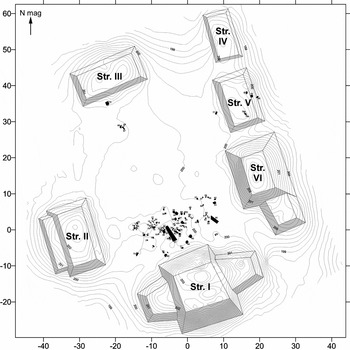
Before our first season, Christian Prager, our project epigrapher, visited the British Museum and redrew both the texts and pictorial content of all the monuments brought to London in 1930 and 1931. Prager's initial assessment was that at least 20 fragments carrying inscriptions were missing. Since the stelae were found and cut up in situ, these fragments presumably were left by the British Museum project in the Stela Plaza. Our work in the Stela Plaza began with vegetation clearing for detailed mapping not only of structures, but also of remaining monument fragments. In the course of three weeks, we located 88 monument fragments and plotted the position of each (Figure 2). Currently, we are analyzing their depositional pattern to determine which of the previously known 21 stelae, three zoomorphic altars, and an unknown quantity of round altars the fragments belong. Each carved fragment has been illustrated, and many have been photographed in both natural and oblique-angle artificial light. We are now beginning the painstaking work of comparing these illustrations with drawings and photographs of incomplete monuments in the British Museum.

Stela Plaza, showing location of in situ monument fragments. Scale is in meters (negatives indicate south or west of datum) measured from an arbitrary datum (0 m east, 0 m north, 200 m above sea level) in the row of stelae; contour interval is 20 cm.
Although this work is still under way and epigraphic analysis is continuing, several important discoveries are worthy of note. First, we found fragments of a fourth zoomorphic altar and a previously unknown stela on Structure V. The altar is different from the three “frogs” or “ocelots” located just north of the stela row and may portray an anthropomorphized turtle. Second, all of the stelae in the group have texts or iconographic content. Another important observation is that Stela F, left whole in the plaza and not illustrated by Sylvanus Morley because of its eroded condition, contains glyph blocks that are still readable in oblique light. The text opens with the Long Count date of 9.16.0.0.0 (a.d. 751), 20 years after what was thought to be the last dated monument at Pusilha. For a number of reasons, we strongly suspect that all the stelae were moved and reset in the stela row at about 9.16.0.0.0. The hieroglyphic stair, located in Moho Plaza, contains a calendar round date that we believe corresponds with 9.18.7.10.3, or a.d. 798. Thus, Prager has extended the known history of Pusilha's occupation forward in time by 67 years. This is important because the Classic Maya Collapse—as dated by the cessation of monument erection at Pusilha—once appeared to have been quite early in southern Belize. The discovery of these new dates and of late stelae at Nim li Punit are in accord with Norman Hammond's (1975) conclusions regarding the late occupation of Lubaantun. Thus, evidence from all three sites argues that the end of Classic Maya civilization in southern Belize should be pushed forward to a.d. 800 or so, consistent with what we know from many other regions, including Copan and Quirigua.
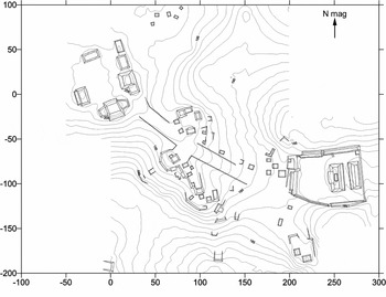
The Stela Plaza is connected by a sacbe to Ballcourt I (Figure 3). Near the middle of the sacbe are several smaller architectural groups that appear to be residential in character. Together, these portions of the site center exemplify cosmological concepts of site planning described by Wendy Ashmore (1991). The Stela Group itself is linked conceptually to the north, the sun at its zenith, the heavens, and the veneration of divine royal ancestors through the stela cult. The ballcourt is located to the south (actually, the southeast) and is associated with the ballgame, the underworld, darkness, the sun at night, and death. Thus, the sacbe, like the world tree, symbolically connects the underworld to the heavens and passes through a residential zone that may symbolize our own world.

Stela Plaza (upper left) and Ballcourt I (lower right). Contour interval is 1 m; scale is in meters measured from an arbitrary datum in the row of stelae; negatives indicate south or west of datum.
Moho Plaza.
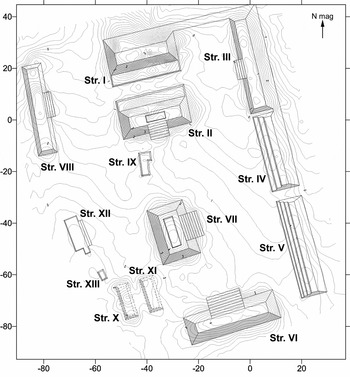
Another focus of both mapping and monument documentation is the Moho Plaza, located 2 km southwest of the Stela Plaza. With the exception of the Gateway Hill Acropolis, this is the largest single group yet found at the site, measuring some 120 m to a side (Figure 4). The largest ballcourt known in southern Belize is located at the north end of Moho Plaza, and the south end is delimited by a large range structure containing a hieroglyphic stair. As stated earlier, we believe that the calendar round date that dedicates the stair and structure—4 Akbal 2 Zotz'—corresponds to 9.18.7.10.3, or a.d. 798.

Moho Plaza, hieroglyphic stair is located on Structure VI. Scale is in meters (negatives indicate south or west of datum) measured from a second arbitrary datum (0 m east, 0 m north, 0 m above sea level) placed near the southwest corner of Structure III; the approximate location of this second datum is 1350 m south, 950 west of the primary site datum in the Stela Plaza; contour interval is 20 cm.
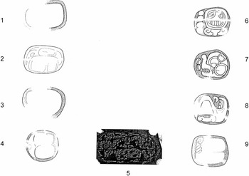
For several reasons, we suspect that the Moho Plaza dates to a time quite late in the occupation of Pusilha. First, the architecture is different from that of other groups. Several structures are fronted by large, megalithic stairs similar to those of Lubaantun and Nim li Punit, sites that apparently reached their apogee after most dated monuments were erected at Pusilha. Second, the ballcourts are anomalous in two ways: (1) the large one is oriented east–west, a pattern typical of Terminal Classic and Postclassic ballcourts; and (2) neither is built in a walled enclosure like the other two ballcourts at Pusilha and those of nearby Lubaantun and Nim li Punit. Third, the glyph blocks of the hieroglyphic stair are particularly strange and are rendered in a style reminiscent of that of Terminal Classic and Postclassic Yucatan (Figure 5). Finally, the group is constructed on a low, flat plain, an occupational pattern not seen elsewhere at the site. Our working hypothesis is that this elite group was occupied at the end of the history of Pusilha, possibly after the dynastic collapse. Ceramics recovered from test pits placed behind mounds and in off-plaza contexts during our 2002 season suggest that Moho Plaza was extensively occupied during the Late to Terminal Classic period.

Hieroglyphic stair, Structure VI, Moho Plaza (drawing by Christian Prager).
Gateway Hill Acropolis.
The dynastic center and palace complex of Pusilha, called the Gateway Hill Acropolis, also was mapped during the 2001 field season (Figure 6). The acropolis is much larger and more complex than previously thought and entirely fills the oxbow in which Gateway Hill is located. In all, it rises at least 60 m above the river in a series of terraces containing stone platforms. Figure 6 displays the terraces and pyramidal mounds that constitute the center of the acropolis. Detailed, scaled plans have been made of the features forming the rest of the complex, but the architecture and topography remain to be surveyed by total station.

Gateway Hill Acropolis. Contour interval is 1 m; scale is in meters (negatives indicate south of datum of in stelae row).
Northeast settlement zone and the north–south transect.
A particularly important facet of our first season was the beginning of systematic mapping. Full-coverage mapping (including detailed topographic mapping) was conducted in the three groups already described, as well as in a portion of the northeastern quadrant of the site. This last area, measuring 33 ha in size, was completely cleared when a milpa fire burned out of control. The area was covered by Leventhal's transects, but the fire exposed many more groups that do not appear in his pace-and-compass map. Although the older map shows 25 structures, we mapped 84 (for a density of 255/km2) and many terrace features (Figure 7). The structure density implies a population density of approximately 920 people/km2.3
This crude estimate of population density is arrived at by assuming 78.5% contemporary occupancy rate (Culbert et al. 1990:115) rather than Hubert Robichaux's (1995:Table 12) 68.0% occupancy rate. We have chosen the higher value because we believe it is more accurate for Pusilha, which seems to have been densely inhabited only during the Late Classic period. The final population density assumes 4.6 individuals per structure. Of course, population estimation in the Maya region is something of a cabalistic exercise. Our point is simply that the density of structures is quite high, well within the range expected for the urban center of a site.

Northeast settlement zone. Contour interval is 1 m; scale is in meters from datum in stelae row.
In 2002, we also surveyed a north–south transect measuring 200 m across by 1.5 km in length (Figure 1). The transect passes through the Stela Plaza and runs to both the Poite and Machaca rivers. In all, 93 mounds and 41 terrace features were found in this .3-km2 survey area, for an overall density of 310 structures/km2 and 140 terraces/km2, implying a population density of approximately 1,100 individuals/km2 (see note 2). The density of structures is greatest on natural ridge tops (560 structures/km2) but also is high within 100 m of either river (240 structures/km2). It is lowest in depressions between ridges (100 structures/km2). We suspect that these depressions were considered less habitable because they collect water in the rainy season. They may have served very well, however, as gardens or milpa, as some are used today.
The purpose of our settlement survey is to understand the spatial distribution of elites and commoners at Pusilha and to determine how the site grew over time. The results of the survey have allowed us to plan test-pitting operations for the 2004 season, with the goal of sampling residential and special-function groups occupied by different segments of the population throughout the history of the site.
Excavations
During the 2002 field season, a total of 24 1-m2 test pits and several extensions were excavated in off-mound, non-architectural contexts in the Stela Plaza, the Moho Plaza, a residential group that we have dubbed Weller's Plaza, and below the Pottery Cave Group. Sherds recovered from these contexts have allowed us to build a multiphase ceramic chronology. Pottery and other artifacts are also providing us with insights regarding the function of various groups. For example, samples from the Pottery Cave Group, Weller's Group, and an excavated mound that we call the Bulldozed Structure all contain a wide range of cooking and storage vessels, as well as copious amounts of jute shell and animal bone. The assemblages therefore suggest to us that these three groups were largely residential in character. In contrast, many more incense burners and far fewer cooking and storage vessels—as well as almost no jute or animal bone—were recovered from test pits in the Stela Plaza and Moho Plaza. We suspect, therefore, that these two groups were largely ceremonial in nature, and—what is more—that ritual feasting was not a significant activity in them.
In addition to the test-pitting program, we conducted extensive salvage operations in April and May 2002 in a structure located in the center of the village of San Benito Poite, approximately 500 m east of the Stela Plaza. This structure was partially destroyed, and two others were completely leveled, by a bulldozer sent to the community the week before Easter (Figure 8). Excavations in the Bulldozed Mound revealed an earlier substructure containing one preserved side, a partially preserved front, and a fragmentary stair that had been partially demolished by the ancient Maya (Figure 9). The Department of Archaeology decided that all of the destroyed final structure should be removed and that the partially preserved substructure should be consolidated. The consolidated platform, located near the center of the modern village, will serve as a permanent reminder that San Benito Poite is located on an important archaeological site.

Photographs of the Bulldozed Mound: (a) before excavation; (b) during excavation, showing partially destroyed substructure and stair disassembled in antiquity; (c) substructure after consolidation.

Plan of the Bulldozed Mound (facing south) and its substructure (facing west). Shaded areas were completely leveled by modern construction activity.
The architectural style of the final stage of the Bulldozed Mound is quite late in date. A late date for the construction and occupation of the final stage is strongly supported by analyses of both ceramic and obsidian artifacts salvaged from the mound. Fine Orange ware was recovered from the final-stage structure, and types closely related to the Ejar complex of Early Postclassic Copan were recovered from its surface and from off-mound contexts. These, along with the presence of central Mexican obsidian from the Zaragoza and Pachuca sources, the introduction of platform grinding as a preparation or rejuvenation technique in prismatic-blade production, and the replacement of El Chayal obsidian with material from the Ixtepeque source, allow us to confidently cross-date use of the final-stage structure to sometime between a.d. 820 and a.d. 1100.
Three radiocarbon assays determined from carbon associated with the deliberate termination of the substructure stair date to the fifth or sixth centuries a.d., but since the carbon was recovered above sealed contexts containing Belize Red (a ceramic appearing in Late to Terminal Classic contexts at Pusilha), we suspect that the dates reflect the burning of old wood, perhaps a lintel or other portion of the earlier substructure.
Ceramic Analysis
The Late Classic assemblage from Pusilha includes various components closely related to established types and groups at other Lowland Maya sites. These include striated utilitarian jars, red-slipped jars (some of which are decorated with impressed designs), large red-slipped bowls, and both polished black and polychrome fine wares. These same general categories of vessels figure prominently in the ceramic assemblage of the neighboring southern Belize site Lubaantun (Hammond 1975), although specific vessel forms differ markedly between the two sites. This pattern may reflect separate subregional systems of ceramic production and distribution associated with each site or temporal differences in their occupations. Although the absolute chronology of neither site is particularly well known, it appears that significant occupation at Lubaantun began much later than at Pusilha. Moreover, Terminal Classic occupation at Lubaantun may have been more substantial than at Pusilha.
The Late Classic ceramics of Pusilha and Lubaantun have many features in common, including the presence of coarse-pasted, short-necked jars (of the Puluacax Unslipped type) that appear to be distinctive to southern Belize. More significant is the pattern of interregional ceramic affiliation reflected in the assemblages of both sites. In terms of type and modal frequencies, the Late Classic assemblage from southern Belize has more in common with contemporary assemblages of sites in the lower Pasion and perhaps northern Peten regions than with those of the Belize Valley. Shared features include red-slipped jars, especially with impressed and stamped designs, that occur at sites in the Petexbatun, Altar de Sacrificios, Seibal and Cancuen in the Pasion region, and at Uaxactun and El Mirador in northern Peten. Such vessels are rare to absent in the Belize Valley, although they do appear at sites just to the north of the Maya Mountains, including various caves in the Chiquibul region (Hammond 1975:305) and at Caracol (Chase 1994:175).
In addition to sharing certain features, the ceramic assemblage of Pusilha departs from that of Lubaantun in the presence of certain vessel forms and modes. These include comales, which are relatively common at Pusilha and at sites in the Upper Pasion and the Dolores Valley to the east. Monkeys, a frequent motif on polychrome bowls from Pusilha and sites in the southeast periphery, appear on incised vessels in certain parts of the lowlands, including the Río Pasion zone. Other design elements (such as floating birds and the “twist-and-bud” pattern) are rare elsewhere in the Maya Lowlands but are common in various polychrome traditions of the southeast periphery. These features are very unusual or absent at Lubaantun.
Although the polychrome vessels of Pusilha share some design elements with polychrome types known from Copan and other sites in the southeast periphery, we have not identified any clear imports from western Honduras or El Salvador. Moreover, the orange- and creamed-based polychrome vessels of Pusilha share forms and general surface-treatment attributes that are clearly related to established groups such as the Saxche-Palmar Orange polychromes of the Pasion and central Peten regions. Finally, the incised and modeled vessels that are distinctive of elite pottery at Copan appear to be extremely rare in the Pusilha ceramic inventory.
Sometime late in the Classic period, perhaps during the Terminal Classic, distinctive ash-tempered Belize Red pottery was introduced to Pusilha. This suggests that economic ties with the Belize Valley became important for the first time at the very end of the eighth century or perhaps during the early ninth century. Belize Red pottery also occurs in late contexts at Lubaantun and almost certainly was imported at that site, as well (Hammond 1975:312).
As noted earlier, a small and distinctive Postclassic assemblage was identified in the ceramic material recovered from the Bulldozed Mound, as well as in surface contexts at several other loci. Although some vessels are relatively well made, most locally produced Postclassic ceramics are quite crude. The chronological placement of this assemblage is somewhat uncertain, although the recovery of a small number of Fine Orange sherds in these same contexts suggests a date no earlier than a.d. 830. The Postclassic ceramics represent a sharp technological break from earlier Late Classic pottery at Pusilha, in a manner similar to that described for the New Town complex of the Belize Valley (Gifford 1976) and for similar Postclassic complexes at other sites, including Copan (Manahan 2000), Cancuen (Bill et al. 2003), the Petexbatun region (Foias 1996), and elsewhere.
Epigraphic Analyses
At least 46 sculptured monuments and monument fragments have been found at Pusilha. This corpus includes at least 21 carved stelae and stelae fragments (Stelae A, A1, B–H, K–U, and Z), three zoomorphic altars (V–X), three ballcourt monuments (BSc 1–3), a hieroglyphic and figural stair (HS 1), and 18 carved fragments (Fragments 1–18). The last category includes pieces of what appear to be a fourth zoomorphic altar and at least one additional stela. In addition to these sculpted monuments, two plain stelae, an unknown quantity of round altars, and numerous uncarved monument fragments have been found in the Stela Plaza, the Gateway Hill Acropolis, the Big Tree Group, and the Plain Stela Group. Twenty-two of the carved monuments and fragments (Stelae C, D, E, F, H, K, M, N, O, P, Q and U, BSc 1, HS 1, Frag 1, 3, 7, 8, 10, 12, 14, 16, 17) contain hieroglyphic texts. Prager (2002, 2003) has presented a detailed epigraphic analysis of the inscriptions of Pusilha, a portion of which is summarized here.
The two earliest dates recorded on the monuments are 8.2.0.0.0 5 Ajaw 8 Sak (a.d. 81) and 8.6.0.0.0 10 Ajaw 13 Ch'en (a.d. 159). References to legendary events on these days are found on two stelae (P and K) that date to the Late Classic (Figures 10 and 11). The first historic date is 9.6.17.8.18 (a.d. 570) and is recorded on Stela P. The latest securely identified date is 9.16.0.0.0 2 Ajaw 13 Tzek (a.d. 751; Stela F), but two other monuments—including the hieroglyphic stair—contain dates that may be as late as a.d. 798. Thus, the historical events described in the Pusilha corpus took place over a period of 181 to 228 years, and the chronology of legendary and historic events spans 670 to 717 years.

Pusilha Stela P (drawing by Christian Prager).

Pusilha Stela K (drawing by Christian Prager).
A total of 38 individuals, of which 21 are chronologically embedded in the history of Pusilha, have so far been identified. Eleven individuals bear the title k'uhul un ajaw (“divine ruler of Pusilha”) and can be identified as kings and queens of Pusilha. The main sign of the emblem glyph is T559, its logographic value is UN (avocado); thus, the rulers of the site are titled the “lords of avocado.” The main sign closely resembles that of the Quirigua emblem glyph. This similarity has led to speculation that the two sites belonged to the same polity (Reents 1982), but it is important to stress that at Quirigua, the main sign is consistently shown lying on its side. Moreover, some examples of the Pusilha emblem glyph contain an affix that further distinguishes it from that of Quirigua. A toponym (T150:witz) that we have nicknamed “Step Mountain” seems to refer to the city of Pusilha or perhaps to an architectural group such as the Gateway Hill Acropolis or Stela Plaza.
In this paper, we focus on the reigns of seven lords and ladies of Pusilha, who ruled between a.d. 570 and a.d. 731 or so (Figures 12 and 13). The historic account at Pusilha starts with Ruler A whose name glyph is read k'awil chan k'inich (Stelae P and D; Figure 10:C5–D5, G5–H5). He ascended the throne on 9.6.17.8.18 (Figure 10:C4–C6) and celebrated the 9.8.0.0.0 period ending as a four k'atun ajaw (i.e., he was between 60 and 80 years of age; Figure 14:C3–D3). Ruler A erected Stelae O and Q to celebrate the katun endings of 9.7.0.0.0 and 9.8.0.0.0. Both of these monuments may have been shattered by enemies who possibly attacked Pusilha on 9.8.1.12.8 (a.d.594). Stela D (Figure 14:D11–C12, D13–C14) mentions that “stelae were broken” (k'asay lakam tu:n) and the “flint and shield were downed” (hub'u:y u tok' u pakal) on this date by an individual whose origin is not known but whose name includes a glyph commonly found in much later texts from the Petexbatun and Pasion regions. Following these events, something happened with the bones and skulls of an unknown individual at a location called the ye-tun “head-place,” which is interpreted as the locale of sacred mortuary rites (Eberl 1999). The date of the possible defeat of Pusilha falls within the reign of one of Copan's greatest kings—Ruler 11, nicknamed B'utz Chan—but it is important to stress that there is no evidence linking Copan to this action. Indeed, it may be that the battle occurred at a place other than Pusilha and that the event commemorated on Stela D had little to do with the polity.

Partial list of rulers of Pusilha (prepared by Christian Prager).

Genealogy of some Pusilha rulers (prepared by Christian Prager).

Pusilha Stela D (drawing by Christian Prager).
Ruler A's successor was called k'ak' u ti' chan and is nicknamed Ruler B (Figure 14:H13). His hieroglyphic name is identical to that of his powerful contemporary, Copan Ruler 11. This raises the possibility that they were one and the same person. But since Ruler B was still living at 9.10.15.0.0 (Stelae P and D), some 20 years after the death of his namesake at Copan, they could not have been the same individual. Moreover, Stela P describes Ruler B as the “first sprout” or first son of Ruler A of Pusilha. Nevertheless, hieroglyphic and iconographic evidence point to the fact that Pusilha was under the cultural influence of Copan during the reign of Ruler B. But it seems that Copan symbolism was only briefly integrated into the iconography of Pusilha, because Ruler B's successors made no use of borrowed iconography. According to the final passage on Stela P, Ruler B's deeds are linked to events that happened in a.d. 81 at the legendary “Chi-Throne-Place” (Figure 10:G10), a sacred location tied to early divine kingship in the southern Maya Lowlands. This reference to the legendary past legitimizes Ruler B's reign.
Ruler C acceded to power and celebrated the katun ending 9.11.0.0.0 (Stela H:A14–A15). He was born less than eight years after Ruler B and may have been his brother. Ruler C's reign was short, and Ruler D (ne' … sak k'uk' hun … aj … ; Figure 11:pF5–pF9) celebrated the 9.12.0.0.0 katun ending. Stela K links this event to a legendary celebration that took place in 8.6.0.0.0 at the already mentioned Chi-Throne-Place (Figure 11:pC6), which perhaps is the ancient name for the city of El Mirador (Guenter 2003). The actor in this mythical celebration is “Foliated Ajaw” (Figure 11:pC3), a legendary person mentioned at Copan, Tikal, and elsewhere. A fascinating body of textual evidence associates “Foliated Ajaw” (also called “Decorated Ajaw” or “Leaf Ajaw”) with the origins of Maya kingship in the Late Preclassic (Guenter 2003). By re-enacting this legendary katun celebration, perhaps representing the birth of ajaw-ship itself, Ruler D legitimized his power in the same mythical language employed on the nearly contemporary Stela I of powerful Copan.
There is no information available about the dynastic and political history of Pusilha between 9.12.0.0.0 and 9.14.0.0.0 (a.d. 672–711). This hiatus corresponds to the last 23 years of the reign of Smoke Imix God (Ruler 12) and the first 17 years of the reign of Waxaklajun Ub'ah K'awil (Ruler 13)—the height of Copan's power in the southeastern Maya Lowlands. On 9.14.0.0.0, however, an individual nicknamed Ruler E set up Stela M. We do not know when he ascended to power or whether his father was a divine ruler of Pusilha. After the death of Ruler E, a woman named ix ich'ak … k'inich (nicknamed Ruler F; Stela E:Ep6–Ep7) became divine ruler of Pusilha. The date of her accession is not recorded, but because her son, Ruler G (Stela E:Ep3–Fp3), erected Stela E on 9.15.0.0.0, it must have occurred during the previous katun. Because Ruler F's parents are not mentioned, it remains unclear whether she was the daughter of Ruler E. She probably reigned only until her son was old enough to ascend to the throne.
Ruler G erected Stela E, which describes his descent. Ruler G's father was named k'inich bakis mo' lahun … and is not described as an ajaw of Pusilha. The paternal grandfather of Ruler G was named hun ew chak muyal chan yoa:t ?ti' k'awil and was an important noble from some unidentified site. Segments of this name phrase appear also at Naranjo, Copan, and Quirigua, suggesting that he came from somewhere in the eastern or southeastern lowlands.
Two other individuals who may have been rulers are mentioned on Stela F and the hieroglyphic stair. The text of the first of these monuments states that a person named k'ak' kal … (Figure15:A5) scattered liquid in celebration of the katun ending 9.16.0.0.0. (a.d. 751). A final individual whose name is not legible is mentioned on the hieroglyphic stair, which probably dates to 9.18.7.10.3 (a.d. 798). The text, read from glyphs 6–9 and then 1–4, says that the stair was dedicated on that date, perhaps by an individual (Figure 5:1) linked to the Pusilha emblem glyph.

Pusilha Stela F (drawing by Christian Prager).
The political history of Pusilha stands out for its antagonistic nature. There is textual evidence (including that described here) as well as iconographic evidence (in the form of depictions of bound captives) of at least eight conflicts between 9.8.1.12.8 and 9.15.0.0.0. Unfortunately, the names of only a few of Pusilha's enemies have survived, and these are all small polities whose locations are unknown. For example, a new fragment found in 2001 depicts a kneeling captive who comes from a place called b'alam.
It is curious that the emblem glyphs of Copan, Quirigua, Tikal, Caracol, Calakmul, and other major powers do not appear at Pusilha. We should be cautious, then, in interpreting every act of Maya warfare as a skirmish in the centuries-long conflict between Calakmul and Tikal (Matt O'Mansky, personal communication, 2004). Nevertheless, other hieroglyphic evidence suggests that Pusilha had significant contacts with sites north of the Maya Mountains, in the Petexbatun and Pasion region, and to the southeast. Stela Q of Pusilha is given a proper name identical to that of Caracol Stela 1, both of which were erected on 9.8.0.0.0. This hints that Pusilha maintained cultural contacts with Caracol. On Stela D, the “Water-Scroll” toponym—seen so often in inscriptions from Aguateca and Seibal—is mentioned twice. Again, a name connected with the 9.8.1.12.8 event contains an element also seen in later inscriptions from that region. With the accession of B'utz' Chan (Ruler 11), an important and powerful ruler of Copan, cultural contacts with the southeast also become visible in the iconography and texts of Pusilha. In fact, Ruler B may even have been named after the great Copan lord.
CONCLUSIONS
Epigraphic, ceramic, and other artifact data have allowed us to extend our knowledge of the occupation of Pusilha from the end of the Early Classic well into the Early Postclassic period. Although we initially expected to find many indications of Copan supremacy, our epigraphic and ceramic analyses point to a wide variety of influences from the southeastern lowlands, western Belize, and especially southwestern Peten.
None of these cultural influences—expressed in art, texts, or objects of material culture—argues strongly that Pusilha was a lesser ally or province beneath the political or economic hegemony of any foreign power, except, conjecturally, during the years immediately following the 9.8.1.12.8 warfare event and during a brief 40-year hiatus in monument erection at the end of the seventh century. The former assumes not only that Pusilha participated but also that it was defeated in that skirmish. This may simply be a reflection of the fragmentary nature of many monuments in the Stela Plaza. Our project has only just begun, of course, and it is entirely possible that our excavations of 24 test pits, several extensions, and one very late structure have missed critical data. During the next five years we plan to continue to search for such data.
Nevertheless, after two seasons we are less certain that Pusilha was annexed by Copan and later asserted its independence, or that Pusilha was a secondary pawn in a centuries-long conflict fought between Tikal and Calakmul. The data we have assembled to date, however, do not imply that either the Dynamic Model or the hegemonic superstate model is incorrect. Indeed, it seems very likely to us that they both are applicable to much of the Maya Lowlands, particularly northern Peten and southern Campeche. But there may have been a “third way” to state formation, one that was more common in peripheral and frontier regions, including both southern and northern Belize, southwestern Campeche, Tabasco, and parts of Chiapas. In these marginal and interstitial places, small regional states may have emerged after about a.d. 500 not because they were annexed by expansionist polities or compelled to enter a centuries-long conflict but for more peaceful reasons. Factors in the development of these secondary states might have included exchange and elite emulation (see Varela and Braswell 2003), or, in a few cases, the colonization of previously underpopulated regions by groups from well-established polities.
As such secondary polities grew between larger states, it is likely that many were annexed by aggressively expansionist kingdoms such as Copan or were coerced into an alliance with Tikal or Calakmul. A few, however, may have seemed too distant, too underpopulated, or too impoverished to be worth the effort. We therefore find ourselves in the unique position of arguing that “our” Maya site was decidedly not the center of the cosmos. That the many and lengthy hieroglyphic texts of Pusilha do not mention even once the powerful kingdoms of Tikal, Calakmul, or Copan—let alone Quirigua or even nearby Nim li Punit—suggests to us that Pusilha maintained its independence and obscurity in a rather peripheral corner of the Maya world throughout its long history.
RESUMEN
¿En que manera desarrolla la organización política al nivel del estado en unidades pequeñas localizadas en áreas periféricas? El Proyecto Arqueológico Pusilha, que ha completado dos temporadas del campo, estudia el desarrollo político y económico en la ciudad antigua maya de Pusilha, ubicado en el distrito de Toledo, Belice. Pusilha surgió en el período clásico temprano (250–600 d.C.) como una unidad política pequeña, pero a través del período clásico tardío (600–800 d.C.) puede haber sido influido por vecinos más grande como Copan y Caracol. Nuestros objectivos son de estudiar las trayectorias políticas y económicas del sitio para entender los procesos de la integración y formación del estado desde una perspectiva de una unidad política secundaria pequeña y marginal.
Nuestra investigación consiste en: (1) el estudio epigráfico y iconográfico de los 46 monumentos conocidos del sitio; (2) el levantamiento topográfico sistemático entero de los 6 a 9 km2 de la ciudad; (3) la excavación de sondeos en contextos no arquitectónicos; (4) la excavación y la consolidación de estructuras selectas; y (5) el analisís de artefactos, especialmente la cerámica. Durante los primeros dos temporadas del campo, descritos en este informe, nosotros condujo el levantamiento sistemático de un transecto (1.5 km de largo por 200 m de ancho) que pasó por el centro del sitio, levantamos otros grupos arquitectonicos, excavamos 24 sondeos de prueba en varios grupos, excavamos y consolidamos una estructura saqueada ocupada durante el período postclásico, desarrollamos la primera cronología cerámica con fases multiples para un sitio del sureño interior de Belice y analizamos las inscripciones jeroglíficas que describen los 700 años de la historia dinástica y mitológica de Pusilha.
ACKNOWLEDGMENTS
The first two seasons of the Pusilha Archaeological Project were generously supported by grants from the School of American Research (2001 and 2002), the Foundation for the Advancement of Mesoamerican Studies, Inc. (2001, grant 00029), the Wenner-Gren Foundation for Anthropological Research (2002), the Archaeology Program of the National Science Foundation (2002, SBE-0215068), and the International Research Fellowship Program of the National Science Foundation (2002, INT-0202581). We are particularly indebted to Lorington Weller for his significant contributions in the field and laboratory and behind the scenes. We also thank Douglas Schwartz and Richard Leventhal, presidents of the School of American Research, for their support of our project. Norman Hammond has been particularly generous with his knowledge of Pusilha and of southern Belize. We also gratefully acknowledge the participation of Susan Maguire and Bonnie Dziadaszek (graduate students at the State University of New York, Buffalo), as well as José Rash (foreman, project surveyor, and present Alcalde of San Benito Poite), Martin Maquin, Jose Ac, Pedro Ack, and Pedro Teck. We also thank the more than 100 additional men and youths from San Benito Poite who served as rotating workers during both seasons and owe a particular debt of gratitude to Cristobal Ack, alcalde of Poite village in 2001–2002, and his wife, Rosaria Butz. Finally, we thank Jaime Awe, Allan Moore, and the staff of the Institute of Archaeology, Government of Belize, for their support of our project.
References
REFERENCES
Ashmore, Wendy A.
1991
Site-Planning Principles and Concepts of Directionality Among the
Ancient Maya.
Latin American Antiquity
2(3):199–226.Google Scholar
Bill, Cassandra R.,
Michael G. Callaghan, and
Jeanette Castellanos
2003
La cerámica de Cancuén y el región del alto
Pasión. In
Proyecto Arqueológico Cancuén: informe temporada
2002, edited by
Arthur A. Demarest and
Tomás Barrientos.
Ms. on file,
Department of Anthropology, Vanderbilt University,
Nashville, TN.
Braswell, Geoffrey E.
2001
Pusilhá Archaeological Project: 2001 Annual Report.
Ms. on file,
Institute of Archaeology, Belmopan, and the Department of Anthropology,
University of California, San Diego.
Chase, Arlen F.
1994
A Contextual Approach to the Ceramics of Caracol, Belize. In
Studies in the Archaeology of Caracol, Belize, edited by
Diane Z. Chase and
Arlen F. Chase, pp.
157–193.
Pre-Columbian Art Research Institute
MonoGRAPH;04014mo;usb 7.
San Francisco.
Culbert, T. Patrick,
Laura J. Kosakowsky,
Robert E. Fry, and
William A. Haviland
1990
The Population of Tikal, Guatemala. In
Precolumbian Population History in the Maya Lowlands, edited by
T. Patrick Culbert and
Don S. Rice, pp.
103–121.
University of New Mexico Press,
Albuquerque.
Eberl, Markus
1999
Tod und Begräbnis in der klassischen Maya-Kultur.
Master's thesis,
Philosophischen Fakultät, Rheinischen
Friedrich-Wilhelms-Universität zu Bonn,
Bonn, Germany.
Foias, Antonia E.
1996
Changing Ceramic Production and Exchange Systems and the Classic
Maya Collapse in the Petexbatun Region.
Ph.D. dissertation,
Department of Anthropology, Vanderbilt University,
Nashville, TN.
University Microfilms,
Ann Arbor, MI.
Gifford, James C.
1976
Prehistoric Pottery Analysis and the Ceramics of Barton Ramie in
the Belize Valley.
Memoirs of the Peabody Museum of Archaeology and Ethnology, Vol.
18.
Harvard University,
Cambridge, MA.
Gruning, E.L.
1930
Report on the British Museum Expedition to British Honduras, 1930.
Journal of the Royal Anthropological Institute
60:477–483.Google Scholar
Guenter, Stanley
2003
El Mirador and Teotihuacan: The Cultural Foundations of Classic
Maya Civilization.
Paper presented at the 10th Annual Symposium of the
Pre-Columbian Society of Washington, DC.
Hammond, Norman
1975
Lubaantun: A Classic Maya Realm.
Monographs of the Peabody Museum of Archaeology and Ethnology,
No. 2.
Harvard University,
Cambridge, MA.
Joyce, Thomas A.
1929
Report on the British Museum Expedition to British Honduras, 1929.
Journal of the Royal Anthropological Institute
59:439–457.Google Scholar
Joyce, Thomas A.,
Thomas Gann,
E.L. Gruning, and
R.C.E. Long
1928
Report on the British Museum Expedition to British Honduras, 1928.
Journal of the Royal Anthropological Institute
58:323–350.Google Scholar
Leventhal, Richard M.
1990
Southern Belize: An Ancient Maya Region. In
Vision and Revision in Maya Studies, edited by
F.S. Clancy and
P.D. Harrison, pp.
124–141.
University of New Mexico,
Albuquerque.
Manahan, T. Kam
2000
Reexaminando los días finales de Copán: Nuevos datos
de la fase Ejar. In
XIII Simposio de investigaciones arqueológicas en Guatemala,
1999, edited by
Juan Pedro Laporte,
Héctor L. Escobedo,
Ana Claudia de Suasnávar, and
Bárbara Arroyo, pp.
1149–1155.
Museo Nacional de Arqueología e Etnología,
Guatemala.
Marcus, Joyce
1992
Dynamic Cycles of Mesoamerican States: Political Fluctuations in
Mesoamerica.
National Geographic Research and Exploration
8:392–411.Google Scholar
Marcus, Joyce
1993
Ancient Maya Political Organization. In
Lowland Maya Civilization in the Eighth Century A.D., edited by
J.A. Sabloff and
J.S. Henderson, pp.
111–183.
Dumbarton Oaks,
Washington, DC.
Marcus, Joyce
1994
The Collapse of Maya States: A Dynamic Process.
Paper presented at the 93rd Meeting of the American Anthropological
Association,
Atlanta, GA.
Marcus, Joyce
1998
The Peaks and Valleys of Ancient States: An Extension of the
Dynamic Model. In
Archaic States, edited by
G.M. Feinman and
J. Marcus, pp.
59–94.
School of American Research,
Santa Fe, NM.
Marcus, Joyce
2003
Recent Advances in Maya Archaeology.
Journal of Archaeological Research
11(2):71–148.Google Scholar
Martin, Simon, and
Nikolai Grube
2000
The Chronicle of Maya Kings and Queens.
Thames and Hudson,
London.
Morley, Sylvanus G.
1938
The Inscriptions of Peten, Volume IV.
Carnegie Institute of Washington Publication 347.
Carnegie Institute of Washington,
Washington, DC.
Prager, Christian M.
2002
Die Inschriften von Pusilha: Epigraphische Analyse und
Rekonstruktion der Geschichte einer klassischen Maya-Stätte.
Master's thesis,
Philosophischen Fakultät, Rheinischen
Friedrich-Wilhelms-Universität zu Bonn,
Bonn, Germany.
Prager, Christian M.
2003
A Study of the Classic Maya Hieroglyphic Inscriptions of Pusilha,
Toledo District, Belize.
Research Reports on Ancient Maya Writing,
Washington, DC,
in press.
Reents, D.
1982
The Hieroglyphic Inscriptions of Pusilha: Preliminary Comments.
Ms. on file,
Institute of Archaeology,
Belmopan.
Robichaux, Hubert R.
1995
Ancient Maya Community Patterns in Northwestern Belize: Peripheral
Zone Survey of La Milpa and Dos Hombres.
Ph.D. dissertation,
Department of Anthropology, University of Texas, Austin.
University Microfilms,
Ann Arbor, MI.
Varela Torrecilla, Carmen, and
Geoffrey E. Braswell
2003
Teotihuacan and Oxkintok: New Perspectives from Yucatán.
In
The Maya and Teotihuacan: Reinterpreting Early Classic Interaction,
edited by
Geoffrey E. Braswell, pp.
249–271.
University of Texas Press,
Austin.
Stela Plaza, showing location of in situ monument fragments. Scale is in meters (negatives indicate south or west of datum) measured from an arbitrary datum (0 m east, 0 m north, 200 m above sea level) in the row of stelae; contour interval is 20 cm.
Stela Plaza (upper left) and Ballcourt I (lower right). Contour interval is 1 m; scale is in meters measured from an arbitrary datum in the row of stelae; negatives indicate south or west of datum.
Moho Plaza, hieroglyphic stair is located on Structure VI. Scale is in meters (negatives indicate south or west of datum) measured from a second arbitrary datum (0 m east, 0 m north, 0 m above sea level) placed near the southwest corner of Structure III; the approximate location of this second datum is 1350 m south, 950 west of the primary site datum in the Stela Plaza; contour interval is 20 cm.
Hieroglyphic stair, Structure VI, Moho Plaza (drawing by Christian Prager).
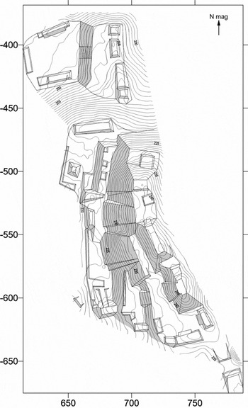
Gateway Hill Acropolis. Contour interval is 1 m; scale is in meters (negatives indicate south of datum of in stelae row).
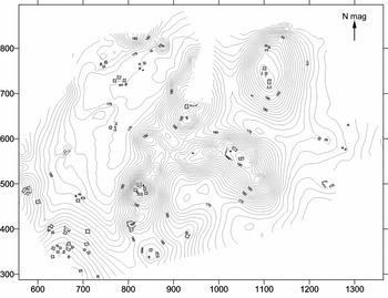
Northeast settlement zone. Contour interval is 1 m; scale is in meters from datum in stelae row.
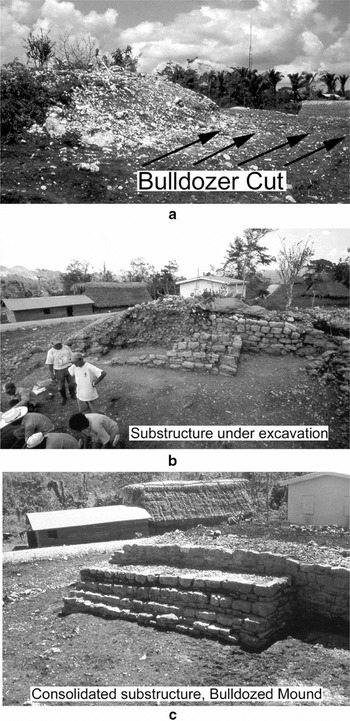
Photographs of the Bulldozed Mound: (a) before excavation; (b) during excavation, showing partially destroyed substructure and stair disassembled in antiquity; (c) substructure after consolidation.
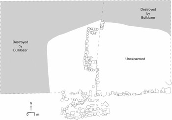
Plan of the Bulldozed Mound (facing south) and its substructure (facing west). Shaded areas were completely leveled by modern construction activity.
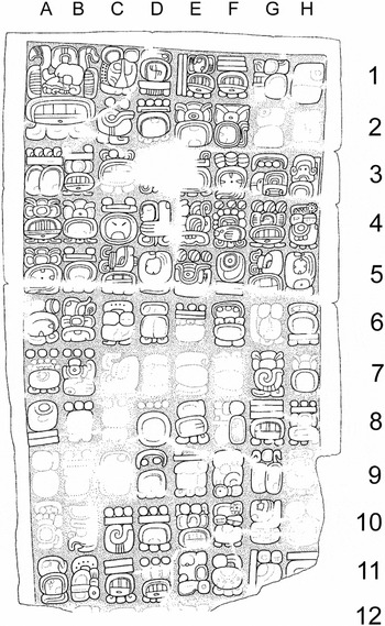
Pusilha Stela P (drawing by Christian Prager).
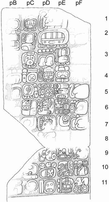
Pusilha Stela K (drawing by Christian Prager).
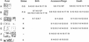
Partial list of rulers of Pusilha (prepared by Christian Prager).
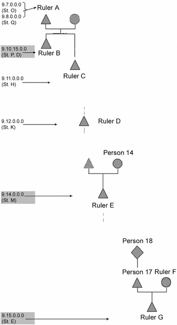
Genealogy of some Pusilha rulers (prepared by Christian Prager).
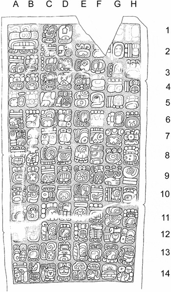
Pusilha Stela D (drawing by Christian Prager).
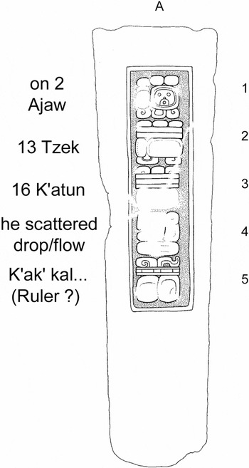
Pusilha Stela F (drawing by Christian Prager).
 You have
Access
- 15
- Cited by