Because stored resources are typically seen as evidence of intensified subsistence activities and a lynchpin for the adoption of specialized cultural practices, roles, and institutions, archaeologists have long studied how communities amassed and cached food resources for later use (e.g., Childe Reference Childe1950). While food storage was originally considered an exclusively agrarian practice (Adams Reference Adams1966), an appreciation for its importance within hunter-gatherer communities has grown since the 1970s, when ethnographic research showed that a significant number of non-agrarian peoples engaged in some sort of delayed consumption (Binford Reference Binford1980; Ingold Reference Ingold1983; Rowley-Conwy and Zvelebil Reference Rowley-Conwy, Zvelebil, Halstead and O'Shea1989; Soffer Reference Soffer1989; Testart Reference Testart1982). Substantial food storage occurs in relatively few ethnographically known hunter-gatherer communities, where it is typically linked to changing settlement, foraging, and mobility patterns, and the establishment of social inequality and complexity (Basgall Reference Basgall1987; Binford Reference Binford1980; Cannon and Yang Reference Cannon and Yang2006; Keeley Reference Keeley1988; Kelly Reference Kelly1995; Morgan Reference Morgan2008; Testart Reference Testart1982; Wesson Reference Wesson1999). The dichotomy between hunter-gatherer communities that store resources and those that do not has likely been overdrawn, however, as resources can be cached at a variety of scales that each have a range of broader social ramifications (Cunningham Reference Cunningham2011; Ingold Reference Ingold1983). Despite its variability and assumed societal importance, the scale and character of hunter-gatherer storage practices are rarely empirically documented by archaeologists, leaving some to lament our poor understanding of storage in the archaeological record and its impact on larger cultural changes, particularly within non-agrarian communities (e.g., Kuijt Reference Kuijt2009:641).
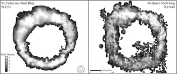
This paper addresses this shortcoming by providing quantitative evidence for food storage practices engaged by hunter-gatherer communities living along the Georgia Bight during the Late Archaic (ca. 4800–3200 cal B.P.). During the Late Archaic, many coastal southeastern Native American communities lived at least part of the year in what appear to have been circular villages, the remnants of which are arcing or circular midden deposits consisting primarily of shellfish remains (Figure 1). Archaeologists have studied these “shell rings” for many years, and they have provided valuable chronometric, seasonal, artifactual, and subsistence data (see Russo Reference Russo2006). However, archaeologists have paid less attention to the interior plazas, largely because early studies suggested that they contained few artifacts or signs of use (e.g., Waring and Larsen Reference Waring and Larson1968). The focus on excavating shell middens has resulted in an interpretation of ring dwellers as highly dependent on aquatic foods (e.g., Colaninno Reference Colaninno2010), with less importance given to terrestrial resources.
Outline of shell rings based on shell probing data.

This paper reverses these trends as it documents excavations conducted in the plazas of two shell rings and reports the discovery of dozens of subterranean features that, based on their distribution, morphology, and the ubiquitous presence of mast at both rings, appear to have been used to store and process tree nuts. Volumetric capacities of pits at each ring, which are then translated into caloric capacity based on experimental studies using both hickory nuts and acorns, provide quantifiable measurements of storage practices. The scale of storage is impressive at both rings and suggests that mast was an important resource in the lives of ring builders.
The broader social ramifications of mast collection, storage, processing, and consumption are beyond the scope of the current paper. Nonetheless, it is critical to understand that the Late Archaic is a pivotal point in Native American history, particularly in the American Southeast and along the southern Atlantic seaboard. It is during the Late Archaic that mobility becomes circumscribed, a social transformation perhaps best demonstrated by the year-round presence of peoples at shell rings (Thompson and Andrus Reference Thompson and Andrus2011). Larger-scale societal bodies also form along the coast and river valleys during the Late Archaic as social boundaries become more distinct (Sassaman Reference Sassaman2010), yet long-distance trade also flourishes and ties together vast portions of the Eastern Woodlands (Gilmore Reference Gilmore2016). It is possible that trans-egalitarian social structures were also forming (Russo Reference Russo, Gibson and Carr2004), perhaps in conjunction with a rising wave of ritual and cosmological gatherings throughout the American Southeast (Claassen Reference Claassen2015). Although these societal shifts are well documented, their causes are less well understood. It is dangerous to view shifts in subsistence as the primary engine of societal change, and this paper makes no such claims. However, the adoption of mast as an important food source can have dramatic effects on interpersonal relations at a variety of scales, particularly when foods are amassed and stored at significant rates (e.g., Bettinger Reference Bettinger2015). Investigating the presence and pervasiveness of mast within the lives of coastal Late Archaic peoples in the American Southeast may therefore offer insights into how and why other societal shifts took place.
The Importance of Scale within Hunter-Gatherer Storage Practices
The role and importance of hunter-gatherer storage has been a subject of considerable debate since anthropologists and archaeologists first began to appreciate its prevalence more than 40 years ago. Traditionally, hunter-gatherer food storage has been associated with prevailing ecological conditions and is considered a “risk reducing mechanism” designed to offset seasonal downturns in resource availability (Binford Reference Binford1980; Keeley Reference Keeley1988; Kelly Reference Kelly1995; Testart Reference Testart1982; Weissner Reference Weissner, Leacock and Lee1982). In areas where critical food resources are storable and subject to high levels of seasonal availability, hunter-gatherers are thought to focus on intensified gathering and stockpiling in order to survive lean times of the year (e.g., Binford Reference Binford1980). Because they can help bridge low-productivity seasons, stored resources often allow reduced residential mobility or even year-round occupation of a single locale (Binford Reference Binford1980). In conjunction with reduced mobility, the presence of stored foods and the ability to amass a surplus may relate to the emergence of elites, class structures, specialization, and inheritability of wealth or status (e.g., Testart Reference Testart1988; Wesson Reference Wesson1999). Population size and density are also thought to increase when stored foods are available (Keeley Reference Keeley1988; Kuijt Reference Kuijt, Bocquet-Appel and Bar-Yosef2008).
In areas with less seasonal variability or with resources not amenable to storage, hunter-gatherers appear to “map onto” available foods and move more frequently (Binford Reference Binford1980; Kelly Reference Kelly1995). Because they are highly mobile and unable to amass surpluses, hunter-gatherer communities without storage appear generally to live in small communities with egalitarian power structures and limited societal or technological specializations (Testart Reference Testart1982; Weissner Reference Weissner, Leacock and Lee1982).
Some authors, notably Ingold (Reference Ingold1983), critique the focus on ecology as a determining factor in the emergence of storage. Ingold argues that labor requirements, social demands for sharing and reciprocity, and the ability to trade all factor into whether communities and individuals set aside materials for later consumption. Ingold highlights how storage practices are employed when there is a mismatch between labor, resources, and consumptive need. While some of these mismatches are ecologically influenced, such as a particularly rich harvest season, others are less so, such as the inability to harvest foods during wartime. Rather than limiting the definition of storage to large-scale investments of labor, such as the development of granaries or amassing stores of smoked fish, Ingold (Reference Ingold1983) argues that a wide variety of much more moderate practices are often employed and that these more moderate practices bridge the extremes between hunter-gatherers that store and those that do not.
Since Ingold's intervention, there has been a great deal of disagreement about how storage practices and social strategies, particularly mobility, interplay with one another. In contrast to the assumption that storage and sedentism always follow one another, others suggest that caching food actually promotes or allows high levels of transhumance (Ingold Reference Ingold1983; Soffer Reference Soffer1989; Stoop Reference Stoop2002). Morgan (Reference Morgan2008), for example, points out that many hunter-gatherers used storage to establish formal seasonal rounds rather than actual year-round residences. These studies stress the need to consider the particular method of storage, what and how much was being stored, and the social context of the practice.
Likewise, others question the assumed connection between storage and emergent elitism. Research shows that the societal ramifications of storage practices typically correlate with the scale and centralization of the practice (Testart Reference Testart1988; Wesson Reference Wesson1999). Large-scale, centralized storage practices often facilitate the development of social complexity and inequality, while more moderate storage practices typically have a relatively minor impact as they provide for occasional dietary short falls yet are too dispersed or small to be effective tools for elite control (Cannon and Yang Reference Cannon and Yang2006; Kuijt Reference Kuijt, Bocquet-Appel and Bar-Yosef2008; Morgan Reference Morgan2012). Indeed, small-scale and dispersed caching of foods may actually reduce the threat of emergent elitism and instead allow increased levels of autonomy as families and individuals could provide for themselves with little need or desire for centralized authority (Ingold Reference Ingold1983; Morgan Reference Morgan2012).
The existence of a wide range of hunter-gatherer storage practices highlights the importance of thinking about storage as a diverse set of activities that vary in scale, intensity, and distribution and that are deployed in different manners based on a variety of factors, only some of which are ecological (Morgan Reference Morgan2012). Despite the need to consider the broad suite of hunter-gatherer storage practices, relatively little effort has been made to quantify the practice (but see Kuijt Reference Kuijt2009:641). In the few instances where hunter-gatherer storage has been quantified, a remarkable degree of gradation has been found, defined, and related to larger social institutions and traditions (DeBoer Reference DeBoer1988; Kuijt Reference Kuijt, Bocquet-Appel and Bar-Yosef2008; Morgan Reference Morgan2012). These studies suggest that careful measurements of storage potential, including volumetrics and caloric capacity, can provide insights into how hunter-gatherer communities conceived of resource ownership, deployed surpluses, and occasionally attempted to centralize labor allocations.
Mast Storage and Processing Features at the St. Catherines Island Shell Rings
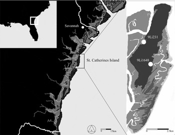
Two recently (2006–2011) excavated sites on St. Catherines Island, Georgia, one of the many barrier islands that line the eastern seaboard, are the focus of this paper (Figure 2). Prior to ca. 4700 cal B.P., St. Catherines Island was wedded to the mainland and was one of a series of Pleistocene dune-ridges lining the Coastal Plain (Thomas Reference Thomas2008). As sea levels rose ca. 4700 cal B.P., lower elevation areas behind the island were inundated, and the island was separated from the mainland (Thomas Reference Thomas2008). The rise—and eventual stabilization in sea levels during the fifth millennium cal B.P.—is the conventional beginning of the Late Archaic within the American Southeast and the point at which many of the barrier islands, including St. Catherines, first become occupied by significant numbers of people (Colquhoun and Brooks Reference Colquhoun and Brooks1986; Gayes et al. Reference Gayes, Scott, Collins and Nelson1992).
Location of St. Catherines Island.

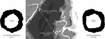
The earliest known occupations on St. Catherines Island are two shell rings, roughly 3 km apart, located on the western and eastern margins of the island (Figure 3; Thomas Reference Thomas2008). Shell rings have long garnered archaeological attention because of their size (some can reach more than 200 m across), formality of deposition, and association with Archaic hunter-gatherers (Russo Reference Russo2006). Currently, shell rings figure prominently in the study of coastal Late Archaic peoples as they are alternatively thought of as evidence of early villages (Calmes Reference Calmes1967; Thompson Reference Thompson2007; Trinkley Reference Trinkley1980) and the emergence of trans-egalitarian social relations (Russo Reference Russo, Gibson and Carr2004), and as locales for large-scale regional feasting and ritual events (Saunders Reference Saunders2004; Thompson and Andrus Reference Thompson and Andrus2011).
Size and location of St. Catherines Shell Ring and McQueen Shell Ring.

While the St. Catherines Shell Ring (9LI231), located on the island's western edge, may have been occupied for a century or two before McQueen Shell Ring (9LI1648), the two are largely contemporaneous, and the majority of construction at each dates to ca. 4200–3900 cal. B.P. (Sanger and Thomas Reference Sanger, Thomas, Thomas and Sanger2010:67). Both rings are roughly the same shape and size, measuring nearly 70 m in diameter with 40-m-wide shell-free plazas in their interiors.
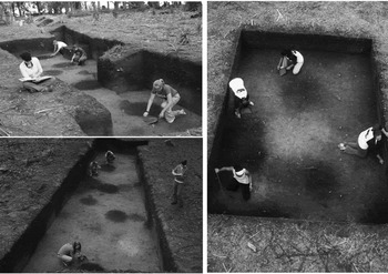
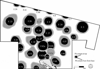
Excavations within the plazas at each ring included blocks measuring 50 m2 at the St. Catherines Shell Ring and 24 m2 at McQueen Shell Ring, both of which revealed a number of circular pits (Figure 4). Pits are somewhat more common at the St. Catherines Shell Ring, where 32 were found and virtually filled the entire block excavation (Figure 5). Pits often overlap, particularly at St. Catherines Shell Ring, where they are more numerous. Pits were relatively consistent in terms of their morphology, distribution, and contents. In terms of size, pits varied between 0.5 and 1.5 m wide and 0.3 and 1.5 m deep. Generally, pits at the St. Catherines Shell Ring were wider and deeper and often had relatively straight walls and flat floors, while the smaller pits at McQueen typically had sloping walls and a more conical profile. Pits at both rings were filled with a dark, sandy loam that stood in stark contrast to the otherwise light tan and yellow subsoils they cut through. Pit fill was largely identical in terms of color and texture to a buried organic horizon from which their upper extents begin. Based on radiometric dates, artifactual finds, and stratigraphic location, the pits and the buried organic horizon from which they originate are Late Archaic in age and overlap with the creation of the shell arc that encircles them (Sanger and Thomas Reference Sanger, Thomas, Thomas and Sanger2010).
Photos of features at St. Catherines Shell Ring (top left, facing west; bottom left, facing east) and McQueen Shell Ring (right, facing east).

Plan view of features found at St. Catherines Shell Ring.

The pits and buried organic horizon spanning the ring plazas contained similar artifactual assemblages made up of Late Archaic pottery, lithic debitage, botanical remains, and very small numbers of vertebrate remains. Invertebrate shells are virtually absent from both contexts, except for a few instances when small fragments or what looks to be a few basketloads were found. Quantities of artifactual remains were variable, but were generally the same in both contexts. With very few exceptions, pits lacked any clear internal stratigraphy, as their fill was homogeneous and artifactual finds were distributed throughout.
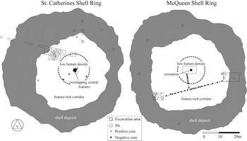
While pits do not have any clear alignments or distributions relative to one another, excavations and coring shows that subterranean features are non-randomly distributed within the ring plazas. The vast majority of buried features are clustered along the exterior edge of the plazas at both rings (Figure 6). Elsewhere, I have described this concentration of pits as a “feature-rich corridor” measuring between 9 and 15 m wide (Sanger and Thomas Reference Sanger, Thomas, Thomas and Sanger2010:59). At the St. Catherines Shell Ring, the feature-rich corridor was defined by our block excavation in the northwest portion of the plaza, a 1-m2 unit in the northern portion of the plaza, and two cores taken in the northern and western portion of the plaza. All of these excavations encountered buried features. At the McQueen Shell Ring, block excavations in the eastern and southwestern portions of the plaza uncovered buried features, as did a transect of cores running between the two.
Location of features at the St. Catherines Island shell rings.

The feature-rich corridors encircle the plaza centers, an area that contains very few buried features (Figure 6). The central portion of St. Catherines Shell Ring plaza was tested by a 12-m2 excavation in its northern portion, a 6-m2 block and core in its direct center, and three cores in its southern half. At the McQueen Shell Ring, the central plaza was sampled with a 32-m2 excavation block in its direct center and a short series of cores that connected the center of the ring with the transect of cores running between the two other excavation blocks. These excavations revealed buried features in the direct centers of both rings, yet none were found within 15 m of these central points.
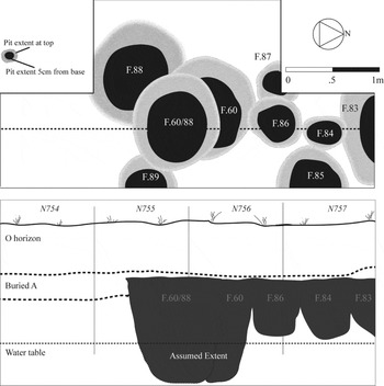
The features found in the direct centers of the rings are different from those found elsewhere along the plaza edges and require more detailed descriptions. At the St. Catherines Shell Ring, excavations uncovered numerous overlapping pits in its center (Figure 7). Because their fill is similar in color, sediment size, and compaction, it is difficult to discern exactly how many pits are in the center of the St. Catherines Shell Ring, but there are at least nine and perhaps even more. The morphology of the central pits at the St. Catherines Shell Ring is quite similar to the pits found elsewhere in its plaza, as they generally have straight walls and flat floors and measure between 40 cm and 100 cm wide and range between 50 cm and more than 150 cm deep. The terminal depths of the deepest pits are unknown because they went beyond the modern water table, at which point the structural stability of the excavation unit was compromised and excavations ceased.
Plan view (top) and profile (bottom) of features found in the center of the St. Catherines Shell Ring.

Pits in the center of the St. Catherines Shell Ring were filled with a sandy loam virtually identical to that found in the pits located along the edge of the plaza. The contents of the central features differed, however, as several contained faunal material, something rarely found in any of the other pits at the St. Catherines Shell Ring. In total, 756 bones were recovered from the central pits at St. Catherines Shell Ring, many of which were burned or calcined (Colaninno and Reitz Reference Colaninno and Reitz2014). Because of their high rates of fragmentation, fewer than half of the bones were identifiable to the family level or below. To date, most are indeterminate mammals, deer (Odocoileus viginianus), Hardhead catfish (Ariopsis felis), indeterminate turtles, and indeterminate bony fishes. One of the central pits at the St. Catherines Shell Ring also contained a ground stone, the only one found at either ring. The stone was worked into a circular shape with flat faces and is similar to “chunkey stones” found at other southeastern sites, stones presumed to have ritual importance, perhaps as gaming stones, and often thought to date to the later Mississippian period (DeBoer Reference DeBoer1993).
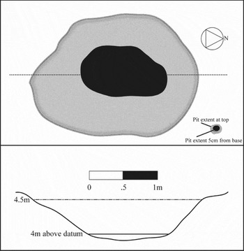
Excavations at the direct center of the McQueen Shell Ring revealed a different archaeological signature, as only a single pit was uncovered, one that contained a multiple person cremation. The pit's morphology is similar to others found along the edge of the plaza. It is roughly circular, measuring more than 1.5 m wide, has sloping walls, and reaches 85 cm in depth before ending at a conical base (Figure 8). Analyses of the recovered remains and associated materials are ongoing, but radiometric assays on the human bones show that they are Late Archaic in age and contemporaneous with the construction of the shell rings. The center pit at McQueen also contained a piece of worked copper, several projectile points, all of which were of Late Archaic types, and moderate amounts of Late Archaic pottery.
Plan view (top) and profile (bottom) of feature found in the center of McQueen Shell Ring.

Archaic Subterranean Storage Facilities Elsewhere in the Eastern Woodlands
The discovery of numerous pits at the two St. Catherines Island shell rings is with few precedents across the southeastern coastline. Currently, no similar finds have been reported from any other Late Archaic shell rings, yet there are occasional descriptions of plaza features that suggest that the finds at St. Catherines Island may not be unique. For example, Calmes (Reference Calmes1967, Reference Calmes1968) noted that pits were found at the Skull Creek shell rings (38BU8), yet very little information was offered beyond a description of a 1.5-m diameter pit filled “with hard, concretion like, material” in the center of the larger ring (Calmes Reference Calmes1967:9–11). Likewise, excavations at A. Brusch Krick (9MC87) revealed a “fire hearth” in the direct center that contained bone, ash, and charcoal (DePratter Reference DePratter1976: 126). A pit filled with dark brown soil, thought to be either a trash or storage pit, was also found at Lighthouse Point Shell Ring, although details are again lacking (Trinkley Reference Trinkley1980). Perhaps the most intriguing description of plaza features comes from Trinkley's (Reference Trinkley1980:256) work at Stratton Place, where he notes numerous circular “ash” pits, all of which measure a meter or more in diameter, lining the interior edge of the ring plaza. None of these findings are conclusive, but they suggest that pits, perhaps similar to those found on St. Catherines Island, may exist at other shell rings.
There are also numerous reports of similar deep pits found at other Archaic sites in the Eastern Woodlands, although their distribution is largely limited to localized pockets in central and western Tennessee, west-central New York, Illinois, and the Savannah River; elsewhere, they are virtually absent (Sassaman Reference Sassaman2010). The pits are typically deep, straight-walled, and flat-bottomed, a pit type absent in subsequent time periods when bell-shaped and conical pits become far more common (DeBoer Reference DeBoer1988). The precise uses of these pits are unknown, although most are thought to be used for storing tree nuts (Sassaman Reference Sassaman2006:161–62). The odd and discontinuous distribution of deep pits makes their presence at the St. Catherines Island shell rings that much more intriguing and may suggest a relationship with similar finds uncovered elsewhere, particularly at broadly contemporaneous sites along the nearby Savannah River.
Sassaman and colleagues have documented the spread of intense pit use along the Savannah River (Sassaman Reference Sassaman2006, Reference Sassaman2010; Sassaman et al. Reference Sassaman, Blessing and Randall2006). According to their studies, some of the earliest intensified pit use can be found at Victor Mills (9CB138), a Late Archaic site located on the Middle Savannah that dates to roughly 4450 cal B.P, several hundred years before the shell rings on St. Catherines Island but contemporaneous with older rings such as those on St. Simons Island. Archaeologists interpret the pits at Victor Mills as used for storing mast and the site as a specialized procurement locale used not by local Savannah River peoples, but, rather, by coastal communities who made seasonal or intermittent forays into the interior, perhaps specifically to gather tree nuts (Sassaman Reference Sassaman2006:111).
Upriver forays made by coastal peoples eventually shifted to more long-term and eventually permanent settlement along the Middle Savannah. Beginning at early settlements including Rae's Creek (9RI327) and Ed Marshal (38ED5), coastal peoples continued to dig deep pits, presumably to store mast (Sassaman Reference Sassaman2006:112–113). After several centuries of living along the Middle Savannah, the descendants of coastal peoples came to settle in larger numbers and in greater densities further upriver including Stallings Island (9CB1) and Mims Point (38ED9).
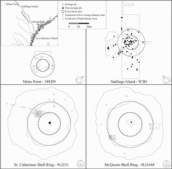
Although Stallings Island had been previously inhabited by local communities, it was abandoned prior to being resettled by coastally derived communities who brought with them an intense use of subterranean features whose distribution suggests a formalized spatial pattern of communal organization (Sassaman et al. Reference Sassaman, Blessing and Randall2006). Specifically, pits were placed within a 30-m-wide circle thought to outline a series of households that together made up a compound or village (Figure 9). Pits found in the “plaza” of the village, defined as a 15-m-wide region in the center of the compound, were often used to house burials, primarily adult interments, while pits found outside of the plaza, but still within the compound, were typically devoid of human remains and thought to be used primarily for storage (Sassaman Reference Sassaman2006:148; Sassaman et al. Reference Sassaman, Blessing and Randall2006:554–555). A similar circular pattern of pit placement was found at Mims Point (38ED9), a contemporaneous Late Archaic site located only 1.2 km north of Stallings Island, also thought to be occupied by coastal transplants (Sassaman Reference Sassaman2006:98; Sassaman et al. Reference Sassaman, Blessing and Randall2006:554–555). Much like the earlier Victor Mills site, many of the pits found at Stallings Island and Mims Point are thought to have been used for storing mast, especially hickory nuts (Sassaman Reference Sassaman2006:161–162). This conclusion is bolstered by the tremendous number of charred nut fragments often found within the pits, particularly at Stallings Island, where a single pit held more than 13,000 charred hickory nut fragments (Sassaman Reference Sassaman2006:161).
Comparison of site structure at Middle Savannah River sites (top, from Sassaman et al. Reference Sassaman, Blessing and Randall2006) and the St. Catherines Island shell rings (bottom).

The similarities between the Late Archaic sites located on the Middle Savannah River and the St. Catherines Island shell rings are immediately apparent and did not elude Sassaman (Reference Sassaman2006, Reference Sassaman2010), who suggested a strong relationship between Savannah River sites and the Chesterfield shell ring located at the mouth of the river. Stallings Island and Mim's Point appear to be circular villages measuring roughly 30–40 m wide and surrounding a 15-m-wide interior plaza, precisely the same dimensions found at the St. Catherines Island shell rings, where the edge of the plazas measure roughly 30–40 m wide and encircle a low-feature area measuring roughly 15 m across (Figure 9). Similarities in morphology between pits at Savannah River sites and the St. Catherines Island shell rings are also notable, particularly at the St. Catherines Shell Ring, where many are straight-walled and flat-bottomed. Likewise, the use of a pit to bury human remains at the McQueen Shell Ring is reminiscent of the finds at Stallings Island, although it is important to point out that cremation was not a common manner of handling the dead along the Savannah River during the Late Archaic.
The Function of Subterranean Features at the St. Catherines Island Shell Rings
Unlike the pits found along the Savannah River, none of the ones uncovered at the St. Catherines Island shell rings contained thousands of nut fragments. As such, the purpose of the St. Catherines Island shell ring pits is debated, with some suggesting that they may have been large postholes (Sanger and Thomas Reference Sanger, Thomas, Thomas and Sanger2010) and others seeing them as wells (Marquardt Reference Marquardt2010).
Current evidence suggests that both of these theories are unlikely. In terms of being postholes, the largest pits at the rings measure more than 1 m in diameter. While erecting such a massive post is indeed possible, placing it would typically require a “slide,” by which I mean an angled entrance into the pit. Without such a slide, posts have to be placed into the pit while standing vertically, not an impossible task, but certainly more difficult than sliding the post into the pit at an angle. The profiles of nearly all of the pits (see below) show that some of the pits are conical in shape, particularly those at the McQueen Shell Ring, and others have slightly expanded openings, yet the largest pits are invariably those with the most constrained openings and the least evidence of any slide or possibility of angling a post into them.
Marquardt (Reference Marquardt2010) suggested that the St. Catherines Island shell rings pits were wells, used during a period of lower sea levels and particularly cool and dry weather patterns. As such, according to Marquardt, shell rings were large water-retention features used to “confine groundwater and rainwater” (Marquardt Reference Marquardt2010:564) and the pits were used to access buried aquifers. I suggest that Marquardt's hypothesis is invalidated by the lack of slumping found in the plaza pits. The sands that make up barrier islands, including St. Catherines Island, are relatively unconsolidated and fine-grained. The result is that open excavations lack structural integrity over the long term, particularly when they are inundated with water. As the pits show no sign of structural failure, it is unlikely that they remained open for extended periods of time, particularly if they were wells that were filled with water.
The variability in depth reached by the pits at the St. Catherines Island shell rings also suggests that they were not wells. While a handful of pits are more than 1 m in depth and several encounter the modern water table, there are also a large number that are only 50 cm deep and several that reach only 30 cm. This variation in depth provides a fundamental problem for interpreting the pits as wells, unless we accept that the freshwater table fluctuated by over 1 m while the rings were in use. Additionally, if sea levels were lower, as Marquardt suggests, a 30-cm hole would never reach a buried aquifer.
Discounting the likelihood that the pits found at the St. Catherines Island shell rings were used as postholes or wells, there are several other potential uses worth exploring. For example, pits are often used for trash collection, yet this seems an unlikely purpose for the shell ring features as they contain roughly the same quantity of pottery and lithic debris as the buried organic horizon from which they originate and, except for a couple of outliers, virtually no shellfish or vertebrate remains. They also lack any signs of heat-alteration or large amounts of burned wood, so they were likely not fire pits or hearths.
Another possibility suggested by the large number of shellfish encircling the pits is that the features were used to process clams, oysters, and other bivalves. Work conducted by Gilmore (Reference Gilmore2016) revealed the presence of hundreds of pits at Silver Glen Run on the St. Johns River in Florida, including a large number created during the Orange period (ca. 4300 cal B.P.), nearly contemporaneous with the St. Catherines Island shell rings. Silver Glen Run is a massive U-shaped construction made of freshwater shellfish and, based on site structure, appears closely related to coastal shell rings. Much like the Late Archaic pits found at both the St. Catherines Island shell rings and along the Savannah River, the Orange-period pits found at Silver Glen are large (typically 70–120 cm in diameter), deep (often greater than 1 m in depth), and spatially constrained to a relatively small area (roughly 700 m2) in which they are numerous and often overlapping. Unlike the pits at the St. Catherines Island shell rings, however, some of the Orange period pits at Silver Glen have lenses of orange oxidized sand, large amounts of charcoal, and concreted mussel shells at their base. According to Gilmore (Reference Gilmore2016), these pits were clearly used for roasting, steaming, or otherwise cooking mollusks. Other pits were filled with shells, often in highly structured, perhaps meaningful ways (Gilmore Reference Gilmore2016).
The pits found at Silver Glen offer a model of what shellfish processing features ought to look like—filled with shells and often showing signs of thermal alteration. Such evidence is missing from the St. Catherines Island shell rings, where only three pits (out of more than 50) had more than a few fragments of shell, and none showed signs of thermal alteration. It is possible that the pits could have been used for other tasks revolving around shellfish consumption—perhaps as storage for dried mollusk meat, but these possibilities seem unlikely and are difficult to investigate archaeologically.
I suggest that the pits at the St. Catherines Island shell rings had several uses, partially predicated on where they were located. Based on their location and relative isolation from the other pits found closer to the edge of the plazas, the central pits at each ring appear to have symbolic, cosmological, or ritual meanings that are presently unclear, but different than the pits found closer to the plaza edges.
While the central pits at each ring appear to serve some sort of ritual or cosmological purpose, the remainder of the subterranean features found along the edges of the ring plazas were likely created for more mundane tasks, including the processing and storage of tree nuts.
Botanical Studies
The ubiquity of hickory nuts, and, to a much lesser degree, acorns, at the shell rings suggests the importance of mast at both sites. Considering that similar pits were used to process and store mast at contemporaneous sites along the Savannah River, I likewise argue that many, if not all, of the subterranean features found in the ring plazas, excepting those in their direct center, were largely, perhaps exclusively, used to process and store tree nuts.
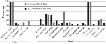
Botanical studies conducted by Ruhl show that hickory nut fragments (Cary sp./spp. and Carya cf. glabra) are ubiquitous at both shell rings (Figure 10). Further details regarding the methods of botanical analysis can be found elsewhere (Ruhl Reference Ruhl2010, Reference Ruhl2015), but Ruhl investigated more than 120 unique proveniences through flotation and micro- and macroscopic studies and found that every provenience contained hickory nut remains. Botanical studies revealed that hickory nuts were typically fragmented, often showed signs of thermal alteration, and were generally limited to nut and shell fragments, with a distinct lack of exterior hulls (Ruhl Reference Ruhl2015). Hickory nut hulls are the outermost layer of the nut. They are quite bulky and are often removed at the point of collection. The relative lack of hulls within the collections from the shell rings suggests that the nuts were processed prior to being brought to the rings (Ruhl Reference Ruhl2015).
Level of ubiquity of nut and wood remains at both shell rings.

While hickory nuts are ubiquitous at both rings, Ruhl's studies show that acorns (Quercus sp.) were largely absent from the St. Catherines Shell Ring and far less common than hickory at the McQueen Shell Ring (Figure 10). The wood of oak trees was also a rare find, particularly at the St. Catherines Shell Ring, where virtually none were recovered.
In many instances, hickory nut and acorn fragments were charred, and it is likely that this was the reason why they survived to the present day. The handling of nut fragments, including the introduction of heat and fire, brings up questions of taphonomy and the possibility that acorns are underrepresented within our samples. Relatively thin-shelled acorns are more likely to fragment and not survive burning, particularly in comparison to hickory nuts, which are remarkably resistant to heat damage. Indeed, there is the possibility that hickory nuts were preferentially used for burning because they offer long-lasting and high-heat flames (Lopinot Reference Lopinot, Jefferies and Butler1982:729). Taken together, the low survivability of acorns and the preferential use of hickory for fires could result in dramatically different levels of representation for each of these nuts. As such, the large numbers of hickory and smaller numbers of acorns at the St. Catherines Shell Rings may or may not accurately reflect the relative importance of these resources.
Ethnographic, Historic, and Experimental Reports
The ubiquity of hickory nuts, and, to a lesser degree, acorns, strongly suggests that mast was an important resource for shell ring residents living on St. Catherines Island. To what extent the plaza features detailed in this paper ought to be interpreted as containers to process and store mast is less secure and largely dependent on three lines of evidence—archaeological, ethnographic/historical, and experimental. In terms of archaeological evidence, while the use of pits at the St. Catherines Island shell rings is in question, they are remarkably similar in terms of morphology and in-site distribution to pits found along the Savannah River that were almost certainly used for storing mast. Given that the residents of Savannah River who used storage likely originated from the coast, below-ground storage of tree nuts may have been a shared cultural tradition for coastal peoples.
The second line of evidence is from ethnographic and historical records in which the use of pits to store and process plant foods, including tree nuts, is well attested across the Eastern Woodlands (e.g., Densmore Reference Densmore1974) including the American Southeast (e.g., Driver Reference Driver1952). These reports frequently describe how mast, particularly acorns, requires a great deal of processing before it can be consumed or placed in storage (Basgall Reference Basgall1987; Gardner Reference Gardner and Gremillion1997). Specifically, pests, including insects and molds, need to be destroyed through heating, parching, boiling, or other means before mast can be set aside for later use. Mast also needs to be cracked open and meat separated from inedible shells and husks prior to consumption. Acorns also typically require leaching. Many of these tasks require shallow pits, and it likely that many of the features found at the St. Catherines Island shell rings were designed for these tasks rather than storage. I return to this possibility through a more detailed analysis of pit size and morphology later in this paper.
The potential for storing mast is attested to by ethnographic and historical accounts, as well as experimental studies, that show that mast can remain edible for years when properly handled and processed, including placing it in underground containers (e.g., Cunningham Reference Cunningham2005). It is important to recognize that there is a level of variability between different species of tree nuts, and even some level of interspecies variation, particularly in terms of how they are best stored and how long they can remain edible (McCarthy Reference McCarthy1993). To my knowledge, no experimental work has been conducted on the types of acorns found on St. Catherines Island (Q. virginiana, Q. hemisphaerica, and possibly Q. alba), so it is unclear how well these tree nuts would respond to long-term storage. Likewise, ethnographic analogies and experimental research on the storage potential of hickory nuts, particularly in underground containers, are lacking. Archaeologists typically assume that hickory nuts have high levels of survivability over an annual cycle, but this remains untested, since deterioration over time was of concern for past peoples and affected the manner in which food was stored (Kuijt Reference Kuijt2015).
The pits in the feature-rich corridors of the rings are currently located in well-drained soils that end before the water table, meaning that they were relatively dry contexts—often an important factor for storing mast. Although little is known about the hydrologic environment during the Late Archaic, current environmental reconstructions suggest that sea levels were near modern levels during the period in which the St. Catherines Island shell rings were formed (Gayes et al. Reference Gayes, Scott, Collins and Nelson1992).
The likelihood that the pits at the St. Catherines Island shell rings were used for storing and processing mast is further strengthened by the abundant numbers of oak and hickory trees on the island. Currently, highly productive oaks (Quercus sp.) can be found in almost every portion of the island, while hickory (Carya glabra and C. ovalis) stands are more limited, yet still quite common (Coile and Jones Reference Coile and Jones1988; Thomas Reference Thomas2008). Much of the island has been logged in historical times, so the current state of tree distribution underestimates precontact levels of mast-bearing trees, as both hickory and oak are near-climax species. Even in this depressed state, there are numerous hickory and oak stands within a few minutes’ walk of each ring (Sanger Reference Sanger and Thomas2008; Semon Reference Semon and Thomas2008) and hundreds, if not thousands, of productive trees across the island.
Quantifying Storage Practices
Although not conclusive, it appears likely that at least some, if not all, of the pits found along the plaza edges of the St. Catherines Island shell rings were used for handling mast, including storing these resources. The volumetric capacity of the pits can indicate the scale of this storage. Such capacities were generated using the 3D Analyst extension for ArcGIS 10.2, taking individual pit morphology into account through three-dimensional reconstructions.
In addition to morphology and volumetrics, I also calculated baseline nutritive values of each storage pit. There are a number of ways to quantify nutritive values, the most popular of which is measuring potential caloric capacity. This is clearly a limited method of measuring nutrition, given that other values are likely just as, if not more, important to the diets of past peoples. Although mast is also valuable to hunter-gatherers for the fat, carbohydrates, and amino acids it provides (Gardner Reference Gardner and Gremillion1997; Messner Reference Messner2011), calories are the preferred proxy currency for tracking nutritional quality (e.g., Bettinger Reference Bettinger2009). Determining the nutritive capacities of storage pits is problematic, however, as it is unclear to what extent pits were used to exclusively store hickory nuts or acorns or whether the resources were mixed. There is also very little evidence regarding how resources were processed and consumed, which again limits the precision of nutritive estimates. Nonetheless, by relying on modern ethnographic and historical accounts, as well as experimental studies, we can estimate nutritive storage potential.
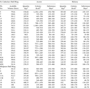
Studies of the caloric value and storage capacity of acorns show a significant degree of interspecies variability (e.g., Barlow and Heck Reference Barlow, Heck, Mason and Hather2002; Basgall Reference Basgall1987; Gremillion Reference Gremillion2002; Mason Reference Mason1992). Semon's (Reference Semon and Thomas2008) research on St. Catherines Island focused on live (Q. virginiana) and laurel (Q. hemisphaerica) oaks; these are currently the dominant species on the island, although it is likely that white oaks (Q. alba) were once present in greater numbers (Semon Reference Semon and Thomas2008). White oak acorns are larger and are best represented by data drawn from Barlow and Heck's research (Reference Barlow, Heck, Mason and Hather2002) on black oak acorns (Q. kelloggii). Using Semon (Reference Semon and Thomas2008) and Barlow and Heck's (Reference Barlow, Heck, Mason and Hather2002) research, along with work conducted by Bettinger and colleagues (Bettinger et al. Reference Bettinger, Malhi and McCarthy1997) that shows that a liter of storage space can hold .69 kg of acorns, I calculated the caloric capacity of each pit. These calculations are tempered by an assumption that each pit was only partially (70 percent) filled by mast resources, as a portion of the volume would have been filled with packing, earth fill, and capping materials (Table 1).
Potential Caloric Value of Features.

a Based on 1 liter = 0.69 kg of acorns.
b Live oak = 2,143 cal/kg, laurel oak = 2,743 cal/kg, black oak = 3,604 cal/kg.
c Based on 2,440 cal/day (Kelly Reference Kelly1995:102).
d Based on 1 liter = 0.73 kg of hickory.
e Unhulled hickory nuts = 840 cal/kg, hulled hickory nuts = 1,435 cal/kg.
As with acorns, the nutritive value of hickory nuts is species dependent. I therefore depend on my own experimental studies conducted using pignut hickory (Carya glabra) from St. Catherines Island (Sanger Reference Sanger and Thomas2008; also see Gardner Reference Gardner and Gremillion1997; Gremillion Reference Gremillion2002; Talaley et al. Reference Talaley, Keller and Munson1984 for similar studies). As noted earlier, based on the lack of hickory nut hulls found at the two rings (Ruhl Reference Ruhl2010), it is likely that hickory nuts were hulled prior to storage. Based on my own studies, a liter of storage space can hold roughly .73 kg of hulled hickory nuts and a kilogram of hulled hickory nuts contains 1,435 kcal (Sanger Reference Sanger and Thomas2008). The caloric capacity of each pit is based on these estimates and a 70 percent fill rate (Table 1).
While raw caloric potential is a useful metric, it is somewhat difficult to contextualize. In order to provide a more manageable measure of storage potential, I transformed raw caloric values for both acorns and hickory nuts into the number of days an individual could subsist (based solely on caloric needs) on stored materials, assuming an average consumption of 2,440 kcal/day (Kelly Reference Kelly1995:102; Table 1).
Discussion of Results
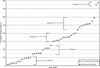
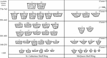
The morphometric and volumetric data drawn from the Late Archaic pits reveals interesting patterns between the two rings. Although variable, pit size and shape cluster in similar ways at both rings (Figure 11). The smallest pits at each contain less than 105 liters of potential storage space. Because they are so shallow, the smallest pits at each ring are poorly suited for storage, as resources would be protected by only a thin lens of soil. Additionally, these very small pits could contain few food resources, perhaps only enough to feed an individual for a few days or weeks. Rather than being storage facilities, these pits are similar to those used to crush, winnow, and otherwise process nuts found among other communities focused on mast (e.g., Basgall Reference Basgall1987; Bettinger Reference Bettinger2015). It is possible that the small pits from the shell rings were likewise used as tools for processing rather than storing mast.
Distribution of features based on available volume.

There is a limited gap in size between the very small pits that measure less than 100 liters (Cluster 1) and slightly larger pits that measure between 140 and 250 liters (Cluster 2). A morphological shift coincides with this size gap in that width-to-depth ratios generally decreases as the pits increase in size (Figure 12). This means that larger pits increase in size more through an increase in depth rather than width. In terms of storage, these deeper pits offer additional protection, so perhaps the division between clusters 1 and 2 reflects a shift from processing to storage facilities. Alternatively, perhaps pits in clusters 1 and 2 were used to process mast in different ways or to process different amounts or types of mast.
Profiles of features from each shell ring organized into size categories.

There are no pits that measure between 252 and 300 liters of available storage space, which may simply be a product of sample size or could attest to a more meaningful division based on function. It is likely that this division in size is meaningful and that pits larger than 300 liters were used for storing rather than processing food resources. Strengthening this argument is that pits larger than 300 liters are often quite deep and it would be difficult to move resources in and out of them without some effort. There are other potential divisions within the larger pits that may be important, including a lack of pits measuring between 401 and 443 liters and between 600 and 743 liters. It is unclear whether these divisions are meaningful and, if so, what they might suggest in terms of resource use, size of gathering parties, and ownership and distribution of materials.
No matter their size, there are distinct morphological differences between pits found at each of the shell rings. Straight-walled and flat-bottomed pits are far more common at the St. Catherines Shell Ring, while conical pits dominate the McQueen finds (with Feature 11a at McQueen being a single outlier; Figure 12). Along with differences in shape, there are consistent differences in size and numbers of pits between the rings. Pits are both more numerous and generally larger at the St. Catherines Shell Ring, where the largest (Feature 5) could contain as much as 776 liters of storage. The largest pit at McQueen (Feature 19), in comparison, is 590 liters. Additionally, only 33 percent of pits encountered at McQueen could hold more than 300 liters of resources, compared to 60 percent of pits at the St. Catherines Shell Ring.
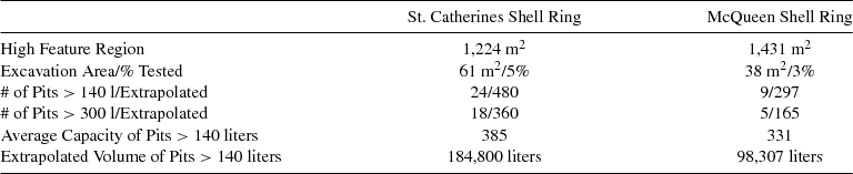
To extrapolate the finds presented within this paper to the rings as a whole, the area of the feature-rich corridors at each ring was calculated and the total number of pits projected, assuming that excavations accurately reflect the overall distribution of pits (Table 2). Results suggest that the St. Catherines Shell Ring could encircle roughly 600 pits, of which 480 hold more than 140 liters of storage space, including 360 measuring more than 300 liters. Similar extrapolations suggest that there are almost 500 pits in the McQueen Shell Ring plaza, including almost 300 larger than 140 liters, of which 165 are larger than 300 liters. Assuming that pits were used only once, that there were no storage pits outside of the feature-rich corridor, and that pits less than 140 liters were not used for storage, extrapolations show that there are more than 180,000 liters of storage potential at the St. Catherines Shell Ring and roughly 100,000 liters at McQueen (Table 2). These calculations give an approximation of the scale of storage practices at each ring and suggest that it was a significant endeavor.
Extrapolated Storage Values.

Conclusions
The discovery of significant storage and processing facilities at the St. Catherines Island shell rings suggests new research directions in which the interpretive primacy of shell fishing and fishing is challenged and mast gathering, processing, and consumption practices are recast as a potential driving force for many of the social shifts that mark the Late Archaic. It is beyond the scope of this paper, but studies show that the adoption of mast as a significant resource often is linked to changing settlement and mobility strategies, understandings of group membership, and the creation of more formalized social boundaries (e.g., Bettinger Reference Bettinger2015). To the extent that similar social changes are recognized within the archaeological record of the coastal American Southeast, archaeologists may be well-served to think of how a mixed subsistence strategy of mast, shellfish, and fish could have created unique social opportunities for Late Archaic peoples, particularly those engaged in creating shell rings.
The findings offered in this paper are complicated by a lack of correlating data from other Late Archaic coastal sites, particularly other shell rings. While there are tantalizing hints that below-ground storage practices might be more widespread, very few excavations have been conducted within other shell ring interiors, making it difficult to determine the extent of storage during this time period. Clearly, directed studies at other rings are warranted, given that a widespread use of below-ground storage would challenge traditional notions of Late Archaic coastal peoples as invested in immediate consumption of food, suggesting instead that they often delayed resource use. The scale at which foods were stored at the St. Catherines Island shell rings is impressive and, if replicated at other Late Archaic coastal sites, will open new research avenues into resource intensification, ownership, and deployment within these communities. Amassing resources within storage containers over multiple years may also help our understandings of shell rings as both year-round residences and points of intermittent convergence. Stored foods could be consumed during lean seasons, thereby allowing continuous occupation of the rings throughout the year. Likewise, as foods amassed, perhaps beyond the annual needs of the community, they could be redeployed as resources for larger gatherings. Ethnographic studies show that mast, particularly acorns, can be utilized as foods for large-scale feasts when accumulated over multiple years and deployed using group labor (McCarthy Reference McCarthy1993).
Finally, the results offered in this paper draw attention to new questions that may help us better understand the social landscape of Late Archaic coastal peoples living in the American Southeast. Specifically, the use of below-ground storage, rather than above-ground facilities, demands explanation (DeBoer Reference DeBoer1988). Because above-ground facilities are generally better at preserving foods and are easier to construct, maintain, and access, there are a limited number of reasons why individuals and groups may decide to bury foods underground. Currently, archaeologists generally view underground food storage as arising from a need to either hide resources or keep track of access (DeBoer Reference DeBoer1988; Wills and Windes Reference Wills and Windes1989). It is unclear whom resources are being hidden from, or why access was being limited at the St. Catherines Island shell rings, but the use of below-ground storage suggests that mast was a valuable resource worthy of protection and that there may have been a level of competition among groups living within the same community during the Late Archaic.
Acknowledgments
Botanical studies by Donna Ruhl were critical to this paper, and she and her staff at the Florida Museum of Natural History have my gratitude. I thank the staff of the American Museum of Natural History, particularly David Hurst Thomas and Lorann Pendleton, who made this research possible, as well as Anna Semon, Matthew Napolitano, Christina Friberg, Elliot Blair, and Rachel Cajigas, who assisted in field and lab work. I am grateful to the St. Catherines Island and the Edward John Noble foundations for providing support for fieldwork as well as the staff of St. Catherines Island, especially Royce Hayes, who facilitated work on the island. Comments by Diana Rosenthal, Kenneth Sassaman, Ian Kuijt, and an anonymous reviewer, as well as Severin Fowles, Terry D'Altroy, Zoe Crossland, and Victor Thompson, enhanced the manuscript. As the author of this paper, I am solely responsible for any errors. Jorge F. Flores provided the Spanish translation, and Luis Borrero checked the Spanish abstract.
Data Availability Statement
Original field notes, drawings, and maps are housed at the American Museum of Natural History. Three-dimensional and volumetric data are housed at Binghamton University.