Introduction
Large ice sheets have existed on Antarctica since at least earliest Oligocene times (Wise et al. Reference Wise, Breza, Harwood, Wei, Zachos, McKenzie and Weissert1991, Barrett Reference Barrett1996), approximately 34 million years ago. Since then it has fluctuated considerably and has been one of the major driving forces for changes in global sea level and climate. The size and timing of these fluctuations has been the subject of considerable debate. Knowing how large ice masses and associated sea ice respond to external forcing is of vital importance, because ice volume variations change 1) global sea level on a scale of tens of metres or more, and 2) the capacity of ice sheets and sea ice as major heat sinks, insulators and reflectors. It is thus important to assess the stability of the cryosphere under a warming climate and higher atmospheric CO2 levels (IPCC Reference Houghton, Ding, Griggs, Noguer, van der Linden, Dai, Maskell and Johnson2001) when ice volumes may reduce, particularly as ice core records have yielded evidence of a strong correlation between CO2 in the atmosphere and palaeotemperatures (EPICA 2004). This concern is justified when CO2 levels are compared with temperature changes in the more distant past (Crowley & Kim Reference Crowley and Kim1995, Pagani et al. Reference Pagani, Zachos, Freeman, Tipple and Bohaty2005). For example, IPCC (Reference Houghton, Ding, Griggs, Noguer, van der Linden, Dai, Maskell and Johnson2001) estimated global mean temperatures in 2300, from ‘best case’ projections of atmospheric CO2, that have not occurred on Earth for over 50 Ma. Since variation in Antarctic ice volume is a major driver of Earth's climate and sea level, much effort has been expended in deriving numerical models of its behaviour. Some of these models have been successfully evaluated against modern conditions (Le Broqc Reference Le Brocq2007). Employing numerical models to evaluate past ice sheet behaviour, using the record of changes in climate (inferred from ice cores, sedimentary facies, and seismic data), palaeoceanographic conditions (inferred from palaeoecology and climate proxies in ocean sediments) and palaeogeography (as recorded in landscape evolution), provides a powerful means by which quantitative process-led assessments of the cryosphere's involvement in a variety of climate change episodes can be established. Such assessment is critical to predicting how the Antarctic Ice Sheet will respond to, and force, future environmental changes.
Recognizing the importance of understanding past changes in Antarctica to comprehending future changes, the Scientific Committee on Antarctic Research has developed a programme, entitled ACE (Antarctic Climate evolution), aimed at facilitating research in the broad area of Antarctic glacial and climate history. In this review we assess five areas of activity in which the ACE programme has been focused. These five examples are not meant to be an exhaustive account of research undertaken on Antarctic climate evolution, but they do provide a means of gauging the variety of activities needed to gain a fuller appreciation of Antarctic glacial history. The review begins with a discussion concerning the onset of glaciation in Antarctica in the earliest Oligocene, with subsequent assessment of ice sheet fluctuations during the Neogene. The review continues with an account of ice sheet changes following the last glacial maximum, and ends with an example for how geological evidence can be used to characterise modern ice sheet processes.
Connection of CO2 and ice sheet inception at the Eocene–Oligocene boundary
Whereas the onset of major, continental-scale glaciation in the earliest Oligocene (Oi-1 event) has long been attributed to the opening of Southern Ocean gateways (Kennett & Shackleton Reference Kennett and Shackleton1976, Kennett Reference Kennett1977, Exon et al. Reference Exon, Kennett, Malone, Brinkhuis, Chaproniere, Ennyu, Fothergill, Fuller, Grauer, Hill, Janecek, Kelly, Latimer, McGonigal, Nees, Ninnemann, Nuernberg, Pekar, Pellaton, Pfuhl, Robert, Röhl, Schellenberg, Shevenell, Stickley, Suzuki, Touchard, Wei and White2002), recent numerical modelling studies suggest declining atmospheric CO2 was the most important factor in Antarctic cooling and glaciation.
As the passages between South America and the Antarctic Peninsula (Drake Passage), and Australia and East Antarctica (Tasmanian Passage) widened and deepened during the late Palaeogene and early Neogene (Lawver & Gahagan Reference Lawver, Gahagan, Crowley and Burke1998), strengthening of the Antarctic Circumpolar Current and Polar Frontal Zone were thought to have cooled the Southern Ocean by limiting the advection of warm subtropical surface waters into high latitudes (Kennett Reference Kennett1977). A number of ocean modelling studies have indeed shown that the opening of both the Drake and Tasmanian gateways reduces poleward heat convergence in the Southern Ocean, cooling sea surface temperatures by several degrees (Mikolajewicz et al. Reference Mikolajewicz, Maier-Reimer, Crowley and Kim1993, Nong et al. Reference Nong, Najjar, Seidov and Peterson2000, Toggweiler & Bjornsson Reference Toggweiler and Bjornsson2000).
Whereas the opening of the Tasmanian gateway broadly coincides with the earliest Oligocene glaciation event (Oi-1) (Stickley et al. Reference Stickley, Brinkhuis, Schellenberg, Sluijs, Röhl, Fuller, Grauert, Huber, Warnaar and Williams2004), the tectonic history of the Scotia Sea remains equivocal. Estimates for the opening of Drake Passage range between 40 and 20 Ma (Barker & Burrell Reference Barker and Burrell1977, Livermore et al. Reference Livermore, Eagles, Morris and Maldonado2004, Scher & Martin Reference Scher and Martin2006), blurring the direct ‘cause and effect’ relationship between the gateways and glaciation. Furthermore, recent atmosphere-ocean modelling (Huber et al. Reference Huber, Brinkhuis, Stickley, Doos, Sluijs, Warnaar, Williams and Schellenberg2004) has shown that the Tasmanian Gateway probably had a minimal effect on oceanic heat convergence and sea surface temperatures around the continent, because the warm East Australia Current does not travel any further south if the gateway is open or closed. The gateway's effect on East Antarctic climate and snowfall was also shown to be minimal, pointing to some other forcing (perhaps decreasing atmospheric CO2 concentrations) as the primary cause of Antarctic cooling and glaciation.
One aspect of recent modelling has focused on the development of coupled climate-ice sheet models capable of running long (>106 yr), time-continuous simulations of specific climate events and transitions (DeConto & Pollard Reference DeConto and Pollard2003a). Simulations spanning the Eocene-Oligocene boundary, while accounting for decreasing CO2 concentrations and orbital variability (DeConto & Pollard Reference DeConto and Pollard2003b, Pollard & DeConto Reference Pollard and DeConto2005), have led to the conclusions that 1) tectonically-forced changes in ocean circulation and heat transport have only a small effect on temperature and glacial mass balance in the Antarctic interior, and 2) Southern Ocean gateways could only have triggered glaciation if the climate system was already near a threshold. Considering the sensitivity of polar climate to the range of CO2 concentrations likely to have existed over the Palaeogene–Neogene (Pagani et al. Reference Pagani, Zachos, Freeman, Tipple and Bohaty2005), CO2 probably played a fundamental role in controlling Antarctica's climatic and glacial sensitivity to a wide range of forcings. This conclusion is supported by a number of numerical modelling studies exploring the role of orbital variability (DeConto & Pollard Reference DeConto and Pollard2003b), mountain uplift in the continental interior (DeConto & Pollard Reference DeConto and Pollard2003a), geothermal heat flux (Pollard et al. Reference Pollard, DeConto and Nyblade2005), Antarctic vegetation dynamics (Thorn & DeConto Reference Thorn and DeConto2006) and Southern Ocean sea ice (DeConto et al. Reference DeConto, Pollard and Harwood2007) in the Eocene–Oligocene climatic transition.
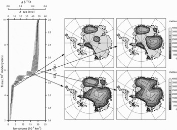
The results of these studies can be summarized as follows. The timing of glaciation on East Antarctica was shown to be sensitive to orbital forcing, mountain uplift, and continental vegetation, but only within a very narrow range of atmospheric CO2 concentrations around 2.8 times pre-industrial level - close to the model's glaciation threshold. Once the glaciation threshold is approached, astronomical forcing can trigger sudden glaciation through non-linear height/mass-balance and albedo feedbacks that result in the growth of a continental-scale ice sheet within 100 kyr (Fig. 1). The timing of glaciation appears to be insensitive to both expanding concentrations of seasonal sea ice and changes in geothermal heat flux under the continent. However, a doubling of the background geothermal heat flux (from 40 to 80 mW m-2) does have a significant effect on the area under the ice sheet at the pressure meltpoint (where liquid water is present), which may have had some influence on the distribution and development of subglacial lakes (Siegert & Dowdeswell Reference Siegert and Dowdeswell1996, Siegert et al. Reference Siegert, Carter, Tabacco, Popov and Blankenship2005).
Ice volume (left) and corresponding ice sheet geometries (right) simulated by a coupled GCM ice sheet model in response to a slow decline in atmospheric CO2 and idealized orbital cyclicity across the Eocene–Oligocene boundary. The sudden, two-step jump in ice volume (left panel) corresponds to the Oi-1 event. The left panel shows simulated ice volume, extrapolated to an equivalent change in sea level and the mean isotopic composition of the ocean (top). Arbitrary model years (left axis) and corresponding, prescribed atmospheric CO2 (right axis) are also labelled. Atmospheric CO2 is shown as the multiplicative of pre-industrial (280 ppmv) levels. Ice sheet geometries (right panels) show ice sheet thickness in metres. Black arrows correlate simulated ice volumes with the geometric evolution of the ice sheet through the Oi-1 event (modified from DeConto & Pollard Reference DeConto and Pollard2003b).

Whereas these modelling studies have certainly improved our understanding of the importance of atmospheric CO2 concentrations relative to other Cenozoic forcing factors, several important model-data inconsistencies remain unresolved. For example, long, time-continuous GCM-ice sheet simulations of an increasing CO2 (warming) scenario, show strong hysteresis once a continental ice sheet has formed, in which the ice surface elevation reaches a maximum where ice accumulation rates are low and subsequently lowers under increasing surface accumulation, which leads to ice build-up (Pollard & DeConto Reference Pollard and DeConto2005). In these simulations, orbital forcing alone is not sufficient to produce the range of Palaeogene–Neogene ice sheet variability (~50–120% of modern Antarctic ice volumes) inferred from marine oxygen isotope records and sequence stratigraphic reconstructions of eustasy (Zachos et al. Reference Zachos, Breza and Wise1992, Pekar & DeConto Reference Pekar and DeConto2006, Pekar et al. Reference Pekar, DeConto and Harwood2006). This points to the importance of additional feedbacks (possibly related to the marine carbon cycle, atmospheric CO2 or even non-linear internal ice sheet processes) in controlling Cenozoic ice sheet variability.
Several recent isotopic analyses of deep sea cores imply ice volumes during the peak Oligocene and Miocene glacial intervals that are too big to be accommodated by East Antarctica alone (Coxall et al. Reference Coxall, Wilson, Pälike, Lear and Backman2005, Holbourn et al. Reference Holbourn, Kuhnt, Schulz and Erlrnkeuser2005, Lear et al. Reference Lear, Rosenthal, Coxall and Wilson2004). Furthermore new isotopic analyses of deep sea sediments of Eocene age are now being taken to imply periods of significant ice cover in both Polar region (Tripati et al. Reference Tripati, Backman, Elderfield and Ferretti2005). These observations suggest that either our interpretations of the proxy data are faulty, or episodic, bipolar glaciation occurred much earlier than currently accepted (Eldrett et al. Reference Eldrett, Harding, Wilson, Butler and Roberts2007). These, among other unresolved controversies related to the climatic and glacial evolution of the high southern latitudes, will be the focus of future modelling and model-data comparisons.
Orbital control on East Antarctic ice sheet dynamics across the Oligocene–Miocene boundary
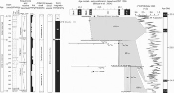
Orbital control of Northern Hemisphere ice sheet volume in the Quaternary ice ages has been well established for a quarter of a century (e.g. Mix & Ruddiman Reference Mix and Ruddiman1984, Shackleton et al. Reference Shackleton, Backman, Zimmerman, Kent, Hall, Roberts, Schnitker, Baldauf, Desprairies, Homrighausen, Huddlestun, Keene, Kaltenback, Krumsiek, Morton, Murray and Westberg-Smith1984, Ruddiman et al. Reference Ruddiman, Raymo, Martinson, Clement and Backman1989, Maslin et al. Reference Maslin, Li, Loutre and Berger1999). Now, through drilling off the Antarctic margin at Cape Roberts it has been shown for the Antarctic Ice Sheet for the period from 33 to 17 million years ago. Around 1500 m of strata in this age range were cored and 55 sedimentary cycles identified, ranging from a few metres to over 60 m in thickness (Naish et al. Reference Naish, Woolfe, Barrett and Wilson2001a). The cyclic variation in lithology records both advance and retreat of the ice margin and the fall and rise of sea level. Two latest Oligocene cycles preserve volcanic ash layers whose ages link them with particular Milankovitch cycles around 24.0 and 24.2 million years ago in the deep sea isotope record (Zachos et al. Reference Zachos, Flower and Paul1997, Naish et al. Reference Naish, Barrett, Dunbar, Woolfe, Dunn, Henrys, Claps, Powell and Fielding2001b) (see Fig. 2). While calibration of the ice volume component of deep sea isotope records (Pekar et al. Reference Pekar, DeConto and Harwood2006, Pekar & DeConto Reference Pekar and DeConto2006) indicates orbital-duration eustatic sea level variations of 10–40 m at this time, it had hitherto not been possible to evaluate these inferred changes from direct evidence for coeval oscillations of sea level and changes in the volume of the Antarctic ice sheets. Naish et al. (in press) used a grain size-derived palaeobathymetry curve (Dunbar et al. in press), to determine the amplitude of eustatic sea level fluctuations, represented by glacimarine cycles in the Cape Roberts core. Their approach estimated the eustatic sea level contribution to the palaeobathymetry curve by using a simple back-stripping approach to constrain total subsidence, decompacted sediment accumulation and glacio-isostasy. The resulting eustatic estimates were consistent with the Late Oligocene δ18O to sea level calibrations of Pekar et al. (Reference Pekar, DeConto and Harwood2006), and show that eustatic sea level fluctuated between around 10 and 40 m, and represented ice volume fluctuations involving 15% to 60% of the present day Antarctic Ice Sheet. This work also implies a δ18O calibration for the Mi-1 glacial excursion that supports a significant expansion of ice on Antarctica, perhaps equivalent to 120% of the present day East Antarctic Ice Sheet, with an attendant fall in global sea level of ~50 m.
Revised age model for Late Oligocene glacimarine cycles 9, 10 and 11 from CRP2/2A showing correlations to the high-resolution ODP Site 1090 δ18O record. 40Ar/39Ar ages on tephra allow cycles 11 and 10 to be correlated with individual Milankovitch-scale, glacial-interglacial cycles within polarity chrons C7n2n and C7n1n, respectively. Cycle 9 is correlated with C6n3n. The Mi-1 glaciation and the Oligocene-Miocene boundary correspond to the 3Ma-duration unconformity at the top of Cycle 9.

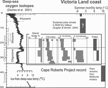
A further conclusion from the Cape Roberts record is that coastal temperature declined progressively through Oligocene and early Miocene time (Barrett 2006, Fig. 3). This is at odds with the initial interpretation of the Zachos et al. (Reference Zachos, Pagani, Sloan and Thomas2001) synthesis of the Cenozoic oxygen isotopic record, where a major shift of the δ18O values at ~25 Ma was interpreted as a warming of the oceans. This has been found to result from splicing records from high and low latitudes (and cold to warm water masses, Pekar et al. Reference Pekar, DeConto and Harwood2006). A revised global Cenozoic proxy temperature record is now overdue.
Trends in climate proxies from the Cape Roberts section for the period 34–17 Ma, compared with the composite deep-sea oxygen isotope curve of Zachos et al. (Reference Zachos, Pagani, Sloan and Thomas2001). The temperature estimates on the right are for interglacial periods and for mean summer monthly (December, January, February) temperature. For the last two million years it is based on the temperature records from Scott Base, Ross Island, since 1957 (-5ºC). See Barrett (Reference Barrett, Hambrey, Christoffersen, Glasser and Hubbard2007) for further explanation.

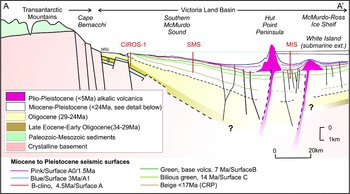
The ANDRILL Program has successfully recovered a 1285 m long succession of cyclic glacimarine sediment with inter-bedded volcanic deposits from beneath the McMurdo Ice Shelf (MIS, forms the north-west corner of the Ross Ice Shelf). The MIS drillcore represents the longest and most complete (98% recovery) geological record from the Antarctic continental margin to date, and will provide a key reference record of climate and ice sheet variability through the Late Neogene (Naish et al. Reference Naish, Powell, Henrys, Wilson, Krissek, Niessen, Pompilio, Scherer, Talarico, Levy, Pyne, Cooper and Raymond2007). Drilling in Southern McMurdo Sound in late 2007 aims to extend the record back to 20 million years (Harwood et al. Reference Harwood, Florindo, Levy, Fielding, Pekar and Speece2006). Together, the Cape Roberts and ANDRILL cores will provide an unprecedented palaeoenvironmental record for this part of the Antarctic margin for the last 34 million years through 3500 m of strata (Fig. 4).
Geological cross-section of McMurdo Sound from seismic stratigraphy and drill hole data (Naish et al., Reference Naish, Levy and Powell2006).

Neogene major advance and retreat episodes of the East Antarctic Ice Sheet
In the 1980s, studies of the Sirius Group and geomorphological investigations in the Transantarctic Mountains led to the development of ‘dynamic’ versus ‘stable’ ice sheet hypotheses, representing widely contrasting views of Neogene Antarctic climate and glacial dynamics (Webb et al. Reference Webb, Harwood, McKelvey, Mercer and Stott1984, Denton et al. Reference Denton, Prentice, Kellogg and Kellogg1984). While comprehensive studies of landscape evolution in the McMurdo Sound region support a persistent ice sheet in central East Antarctica through Neogene time (Sugden & Denton Reference Sugden and Denton2004), preserved fragments of a pre-mid Miocene landscape carved by temperate ice have been recognized (Hicock et al. Reference Hicock, Barrett and Holme2003) and the extreme relief of the Transantarctic Mountains has been linked to continued erosion in the valley floors while the summit tops remained frozen (Stern et al. Reference Stern, Baxter and Barrett2005). Based on compositional studies of the glacigenic sedimentary rocks themselves, Passchier (Reference Passchier2001, Reference Passchier2004) concluded that the Sirius Group could have been deposited concurrently with stepwise glacial denudation of the Transantarctic Mountains.
Nevertheless, recent drilling by the Ocean Drilling Program in Prydz Bay, field studies of the Pagodroma Group exposed on land, and numerical modelling studies, provide evidence for a more complex behaviour of the Neogene East Antarctic Ice Sheet. The importance of large outlet glaciers as major drainage pathways of the East Antarctic Ice Sheet is apparent in RADARSAT data (Jezek Reference Jezek2003) and from the presence of Neogene trough mouth fans, represented by sediment wedges on the continental slopes seaward of large glacial troughs (O'Brien & Harris Reference O'Brien and Harris1996, Bart et al. Reference Bart, De Batist and Jokat1999, Reference Bart, Anderson, Trincardi and Shipp2000).
The Lambert Glacier is the largest fast flowing outlet glacier in the world and drains c. 12% of the East Antarctic Ice Sheet into Prydz Bay. During advances of the Lambert Glacier to the shelf break, glacigenic debris flows built up a trough mouth fan on the continental slope. ODP Leg 188 drilled through the upper portion of the Prydz Channel trough mouth fan at Site 1167, revealing evidence of repeated advances of the Lambert Glacier across the Prydz Bay shelf until the middle Pleistocene (Passchier et al. Reference Passchier, O'Brien, Damuth, Januszczack, Handwerger and Whitehead2003, O'Brien et al. Reference O'Brien, Cooper, Florindo, Handwerger, Lavelle, Passchier, Pospichal, Quilty, Richter, Theissen and Whitehead2004). The Pagodroma Group occurs 200–500 km landward of Prydz Bay and consists of massive diamicts and boulder gravels deposited in an ice proximal environment near a grounding-line, and stratified facies representing more distal iceberg deposition. The depositional environments are considered to be analogous to the modern fjords of East Greenland with fast flowing polythermal tidewater glaciers (Hambrey & McKelvey Reference Hambrey and McKelvey2000a). The formations have ages ranging from early Miocene (or possibly Oligocene) to Pliocene–Pleistocene (Hambrey & McKelvey Reference Hambrey and McKelvey2000a, Whitehead et al. Reference Whitehead, Harwood and McMinn2003) and indicate periods of significant glacial retreat (Hambrey & McKelvey Reference Hambrey and McKelvey2000b, Passchier & Whitehead Reference Passchier and Whitehead2006, Whitehead et al. Reference Whitehead, Ehrmann, Harwood, Hillenbrand, Quilty, Hart, Taviani, Thorn and McMinn2006).
Studies combining results from ODP Site 1165 off Prydz Bay and seismic data show that changes in margin architecture at c. 3 Ma are related to changes in glacial thermal regime (Rebesco et al. Reference Rebesco, Camerlenghi, Geletti and Canals2006, Passchier Reference Passchier, Cooper and Raymond2007). Indeed, stable isotope studies (Hodell & Venz Reference Hodell and Venz1992), and interpretations of siliceous microfossils (Bohaty & Harwood Reference Bohaty and Harwood1998, Whitehead et al. Reference Whitehead, Wotherspoon and Bohaty2005) indicate low sea ice concentrations and relatively high sea surface temperatures in the early Pliocene with a cooling trend occurring from the middle Pliocene onward. Previously, based on results from ODP Site 745 in the East Kerguelen sediment drift, Joseph et al. (Reference Joseph, Rea, van der Pluijm and Gleason2002) had argued that a stable East Antarctic Ice Sheet had established itself during the middle Pliocene. However, they also found that enhanced sediment accumulation from a less stable, wet-based, East Antarctic glacial source occurred periodically as short-term events until the middle Pleistocene (Joseph et al. Reference Joseph, Rea, van der Pluijm and Gleason2002).
The combined studies of ODP cores and field studies of the Pagodroma Group provide evidence of major shifts in the position of the grounding-line of the Lambert Glacier through the Late Neogene. Numerical modelling studies of erosion and sediment supply suggest that, besides climate, continued excavation and overdeepening of the glacial trough during ice advance phases is an important factor controlling the dynamics of the Lambert Glacier in the late Pleistocene (Taylor et al. Reference Taylor, Siegert, Payne, Hambrey, O'Brien, Cooper and Leitchenkov2004, O'Brien et al. Reference O'Brien, Goodwin, Forsberg, Cooper and Whitehead2007). Complete deglaciation as proposed in the dynamic ice sheet hypothesis has not been demonstrated in any of the datasets, and recent PRISM ice sheet reconstructions show the East Antarctic interior remaining ice covered (Hill et al. Reference Hill, Haywood, Hindmarsh, Valdes, Williams, Haywood, Gregory and Schmidt2007). However the modelling does show significant ice loss at the margins, consistent with the retreat of fast flowing outlet glaciers associated with recognizable changes in sea level at continental margins elsewhere. Recent studies with coupled ocean-atmosphere general circulation models also re-emphasize the role of Antarctic terrestrial ice cover and sea ice extent during periods of warming and the need to improve our knowledge about Neogene ice configurations (Haywood & Valdes Reference Haywood and Valdes2004).
Synchroneity of late deglacial ice retreat from widely separated areas of Antarctica's continental margin
The nature and timing of the last large-scale, rapid warming event in Antarctica is an especially interesting target for scientific research given projections of significant warming in the centuries ahead (IPCC 2007). The retreat of Antarctica's ice sheet following the last glacial maximum (LGM) has been studied for more than 30 years via marine geology and continental glacial geomorphology (Anderson Reference Anderson1999, Anderson et al. Reference Anderson, Shipp, Lowe, Wellner and Mosola2002, Domack et al. Reference Domack, Amblas, Gilbert, Brachfeld, Camerlenghi, Rebesco, Canals and Urgeles2006, and many others), and yet many questions remain regarding the timing, speed, and style of ice retreat. These questions are directly applicable to projections of climate and ice sheet behaviour into the future. How fast can Antarctica's ice sheet retreat during periods of warming (particularly as future warming may be greater than at any period since the Pliocene)? Is the style of past retreat suggestive of constant and steady sea level rise or do we see evidence of abrupt short-lived yet rapid intervals of ice retreat? How much did Antarctic glacial ice melting contribute to the global ocean meltwater pulses of the last deglaciation?
Antarctic marine geologists have recently collected expanded Holocene sedimentary sections from continental shelf basins by drilling and ultra-long piston coring (Crosta et al. Reference Crosta, Crespin, Billy and Ther2005, Leventer et al. Reference Leventer, Domack, Dunbar, Pike, Stickley, Maddison, Brachfeld, Manley and McClennen2006, Anderson et al. Reference Anderson, Wellner, Bohaty, Manley and Wise2006). By dating the biogenic sediments (indicative of marine productivity) or other open marine sediments immediately overlying the LGM diamict, it is possible to estimate the timing of ice retreat from outer and mid-shelf regions (Licht et al. Reference Licht, Jennings, Andrews and Williams1996, Leventer et al. Reference Leventer, Domack, Dunbar, Pike, Stickley, Maddison, Brachfeld, Manley and McClennen2006). At present there are still relatively few dates from these kinds of deposits and in fact there has been much focus in the literature on establishing the timing and extent of maximum ice advance during the LGM and the general character of deglaciation (e.g. Anderson et al. Reference Anderson, Shipp, Lowe, Wellner and Mosola2002) rather than the nature of discrete periods of rapid ice retreat.
Radiocarbon dating of Antarctic marine sediments is plagued by a variety of difficulties, including variable water column carbon reservoir ages and sedimentary reworking that results in the mixing of older and younger materials (Domack et al. Reference Domack, Jull, Anderson, Linick and Williams1989, Berkman & Forman Reference Berkman and Forman1996, van Beek et al. Reference van Beek, Reyss, Paterne, Gersonde, van der Loeff and Kuhn2002). However, independent estimates of reservoir age corrections are becoming available (Van Beek et al. Reference van Beek, Reyss, Paterne, Gersonde, van der Loeff and Kuhn2002) as are palaeomagnetic intensity age determinations for the deglacial interval (Brachfeld et al. Reference Brachfeld, Domack, Kissel, Laj, Leventer, Ishman, Gilbert, Camerlenghi and Eglington2003) that serve to improve our ability to estimate the timing of key events on the Antarctic shelf during deglaciation. For example, Table I shows age estimates for the most recent onset of rapid deglacial ice retreat from Prydz Bay, the Ross Sea, Mac. Robertson Land, and the western shelf of the Antarctic Peninsula. To this list we add a palaeomagnetic age estimate of 10 700 ± 500 yrs bp for the conclusion of the transition from grounded ice to a floating Larsen Ice Shelf (64°47.1′S, 60°21.5′W, 901 m water depth; Brachfeld et al. Reference Brachfeld, Domack, Kissel, Laj, Leventer, Ishman, Gilbert, Camerlenghi and Eglington2003).
Radiocarbon-based estimates of the date of onset of the most recent rapid deglacial ice retreat from shelf basins in East and West Antarctica.

aDomack et al. (Reference Domack, Jull, Donahue, Barron and Larsen1991), corrected for reservoir age but not calibrated.
bLeventer et al. (Reference Leventer, Domack, Dunbar, Pike, Stickley, Maddison, Brachfeld, Manley and McClennen2006), scaphapod carbonate, uncorrected 14C age.
cStickley et al. (Reference Stickley, Pike, Leventer, Dunbar, Domack, Brachfeld, Manley and McClennen2005), acidified organic matter, uncorrected 14C age.
dHarris & O'Brien (Reference Harris and O'Brien1998), Sedwick et al. (Reference Sedwick, Harris, Robertson, McMurtry, Cremer and Robinson1998, Reference Sedwick, Harris, Robertson, McMurtry, Cremer and Robinson2001), corrected for reservoir age but not calibrated.
eDomack et al. (Reference Domack, Leventer, Dunbar, Taylor, Brachfeld and Sjunneskog2001), Dunbar et al. (Reference Dunbar, Ravelo, Domack and Leventer2002), interpolated age of base of laminated biogenic unit.
fDomack et al. (Reference Domack, Jull, Anderson, Linick and Williams1989), based on many cores, corrected for surface ages.
§Calibrated calendar year ages are derived through calibration using CALIB 4.2 and 5.0 (Stuiver et al. Reference Stuiver, Reimer and Reimer2005). Reservoir ages for the ODP 1098 were accomplished using the variable reservoir ages of van Beek et al. (Reference van Beek, Reyss, Paterne, Gersonde, van der Loeff and Kuhn2002).
The developing view is one of the onset of rapid and synchronous retreat of ice from widely separated regions of Antarctica's continental shelf beginning at ~11 500 calendar years bp and lasting for up to ~1000 years. This apparent synchroneity is unexpected, given previous inferences of large geographic asynchroneity in the timing of maximum glacial advance and subsequent early deglacial history along Antarctica's margin (Anderson et al. Reference Anderson, Shipp, Lowe, Wellner and Mosola2002). However, a rapid retreat of ice from widespread regions of Antarctica's continental shelf beginning about 11 500 years ago is not necessarily inconsistent with observations of asynchroneity earlier during the last deglaciation. A threshold may have been crossed, such as sea level or temperature rise, which forced a continent-wide response. The significance of this rapid retreat event is threefold.
1) It suggests that a global or hemispheric forcing agent was responsible for rapid loss of ice rather than regionally variable fluctuations in local energy balance or the dynamics of ice and ice streams interacting with bedrock and the ocean.
2) The timing coincides with estimates for the initiation of global meltwater pulse 1B (taken as 11 500 to 11 000 calendar years bp, after Fairbanks Reference Fairbanks1989), allowing for the possibility that loss of Antarctic ice contributed significantly to this event rather than accepting that virtually all meltwater came from the Northern Hemisphere ice sheets.
3) Synchroneity implies the sudden release of large volumes of freshwater into the Southern Ocean, raising the possibility of significant oceanic stratification and concomitant changes in productivity, nutrient fluxes, and the control of atmospheric CO2 levels by the Southern Ocean
Subglacial processes and flow dynamics of former Antarctic ice streams from marine geology and geophysics
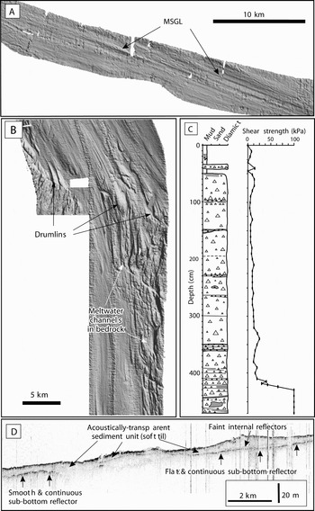
Recent marine geophysical and geological research from the Antarctic continental shelf has resulted in significant advances to our understanding of the extent, timing and dynamic behaviour of the West Antarctic Ice Sheet and the Antarctic Peninsula Ice Sheet during the last glacial maximum, as well as the processes and conditions at the former ice sheet bed. This research indicates extensive ice sheets in West Antarctica and the Antarctic Peninsula at the last glacial maximum. The ice sheet was positioned at, or close to, the shelf edge around the Peninsula, and in the Bellingshausen Sea and Pine Island Bay (Anderson et al. Reference Anderson, Shipp, Lowe, Wellner and Mosola2002, Ó Cofaigh et al. Reference Ó Cofaigh, Pudsey, Dowdeswell and Morris2002, 2005a, Lowe & Anderson Reference Lowe and Anderson2002, Heroy & Anderson Reference Heroy and Anderson2005, Evans et al. Reference Evans, Dowdeswell, Ó Cofaigh, Benham and Anderson2006). In these areas large glacial troughs extend across the continental shelf, and sedimentary and geomorphic evidence from these troughs indicates that they were occupied by grounded ice streams during, or immediately following, the last glacial maximum (e.g. Canals et al. Reference Canals, Urgeles and Calafat2000, Reference Canals, Casamor, Urgeles, Calafat, Domack, Baraza, Farran and De Batist2002, Wellner et al. Reference Wellner, Lowe, Shipp and Anderson2001, Camerlenghi et al. Reference Camerlenghi, Domack, Rebesco, Gilbert, Ishman, Leventer, Brachfield and Drake2001, Lowe & Anderson Reference Lowe and Anderson2002, Gilbert et al. Reference Gilbert, Domack and Camerlenghi2003). This evidence includes elongate subglacial bedforms such as drumlins and mega-scale glacial lineations orientated along trough long axes (Fig. 5a & b).
Representative geophysical and geological records of palaeo-ice stream flow and deposition from bathymetric troughs on the Antarctic continental shelf. a. Swath bathymetry shaded relief image of mega-scale glacial lineations formed in sediment at the mouth of the Ronne Entrance, Bellingshausen Sea. b. Swath bathymetry showing sea-floor morphology as a shaded relief image in middle-outer Marguerite Trough, Antarctic Peninsula. Note subglacial meltwater channels and bedrock drumlins. The drumlins become highly attenuated downflow and evolve into sedimentary lineations. c. Core log and shear strength plot of sub-ice stream sediments, Marguerite Trough. Note the low shear strength massive till underlain by high shear strength (> 98 kPa) (stiff) till. d. TOPAS sub-bottom profiler record from the Ronne Entrance showing acoustically transparent sediment unit (soft till) sitting above a prominent basal reflector (arrowed). This profile is located perpendicular to the former direction of ice flow. Modified from Ó Cofaigh et al. (Reference Ó Cofaigh, Larter, Dowdeswell, Hillenbrand, Pudsey, Evans and Morris2005a, 2005b).

Mega-scale glacial lineations can attain lengths of greater than 20 km within the troughs and are characteristically formed in a weak (0–20 kPa) porous and deformable till layer (Fig. 5c & d) (Wellner et al. Reference Wellner, Lowe, Shipp and Anderson2001, Shipp et al. Reference Shipp, Wellner, Anderson, Dowdeswell and Ó Cofaigh2002, Ó Cofaigh et al. Reference Ó Cofaigh, Pudsey, Dowdeswell and Morris2002, Reference Ó Cofaigh, Dowdeswell, Allen, Hiemstra, Pudsey, Evans and Evans2005b, Reference Ó Cofaigh, Evans, Dowdesell and Larter2007, Dowdeswell et al. Reference Dowdeswell, Ó Cofaigh and Pudsey2004, Evans et al. Reference Evans, Pudsey, Ó Cofaigh, Morris and Domack2005, Hillenbrand et al. Reference Hillenbrand, Baesler and Grobe2005). Such weak tills have been identified and mapped in all the palaeo-ice stream troughs investigated to date. They tend to be confined to the troughs and are not widely observed in the inter-trough areas. The association of this weak porous till layer with highly elongate subglacial bedforms implies that the rapid motion of these ice streams was facilitated, at least in part, by subglacial deformation of the soft bed. Geophysical data also indicate significant transport of subglacial till towards former ice stream termini (Ó Cofaigh et al. Reference Ó Cofaigh, Evans, Dowdesell and Larter2007).
Subglacial geology exerted a major control on ice stream development. A transition from crystalline bedrock to a sedimentary substrate within these troughs characteristically marks the onset of streaming flow. However, in Marguerite Trough (the cross-shelf bathymetric trough emanating from Marguerite Bay on the west side of the Antarctic Peninsula), streaming flow appears to have commenced over the crystalline bedrock by enhanced basal sliding, with the highest flow velocities occurring over the sedimentary substrate further downflow by, at least in part, subglacial deformation. This indicates spatial variation in the mechanism of rapid flow beneath individual ice streams. Subglacial meltwater channels eroded into crystalline bedrock in Pine Island Bay and Marguerite Bay (Ó Cofaigh et al. Reference Ó Cofaigh, Pudsey, Dowdeswell and Morris2002, Reference Ó Cofaigh, Dowdeswell, Allen, Hiemstra, Pudsey, Evans and Evans2005b, Lowe & Anderson Reference Lowe and Anderson2003) demonstrate the development of organised drainage systems and the evacuation of meltwater beneath these ice streams. In the case of Mertz Trough in East Antarctica, McMullen et al. (Reference McMullen, Domack, Leventer, Olson, Dunbar and Brachfield2006) show that meltwater evacuation occurred during deglaciation.
A variety of glacial geomorphic features imaged on geophysical records and supplemented by investigations of core sedimentology indicate that the rate of ice stream retreat varied between different bathymetric troughs. For example, in Marguerite Trough subglacial till is overlain by a thin unit of (de)glacial sediment, and pristine mega-scale glacial lineations recording former streaming flow along the trough are not overprinted by moraines (Fig. 5). This suggests that during deglaciation, the Marguerite Trough ice stream underwent rapid floatation and collapse across much of its bed (Ó Cofaigh et al. Reference Ó Cofaigh, Dowdeswell, Allen, Hiemstra, Pudsey, Evans and Evans2005b), and it contrasts with slower ice stream recession in the Larsen-A region (Evans et al. Reference Evans, Pudsey, Ó Cofaigh, Morris and Domack2005), the Bellingshausen (Ó Cofaigh et al. Reference Ó Cofaigh, Larter, Dowdeswell, Hillenbrand, Pudsey, Evans and Morris2005a) and Ross seas (Shipp et al. Reference Shipp, Wellner, Anderson, Dowdeswell and Ó Cofaigh2002, Mosola & Anderson Reference Mosola and Anderson2006), and in Mertz Trough on the Wilkes Land continental margin (McMullen et al. Reference McMullen, Domack, Leventer, Olson, Dunbar and Brachfield2006). This implies marked variations in the response of Antarctic palaeo-ice streams to climate warming during regional deglaciation and demonstrates that retreat of marine-based ice sheets is not necessarily uniformly rapid even in areas of reverse bed slope. This appears sensible given satellite observations of ice surface changes at the margins of Antarctic ice streams are noticeably different (Davis et al. Reference Davis, Yonghong, McConnell, Frey and Hanna2005). Such variability may be due to differences in ocean-temperature at the ice-water interface across the ice sheet margin (e.g. Payne et al. Reference Payne, Vieli, Shepherd, Wingham and Rignot2004).
Summary and future activities
Analysis of geological evidence, often in conjunction with numerical modelling studies, has over the past few years generated substantial insights into the Cenozoic history of the Antarctic ice sheet and climate.
The traditional explanation for the genesis of ice in Antarctica related the tectonic opening of the Drake Passage with the development of the Antarctic Circumpolar Current and the isolation of Antarctic climate. Numerical modelling suggests, however, that while the timing of this first ice sheet, at around 34 million years, is likely to have been connected with a combination of the onset of the circumpolar current and orbital forcing, ice sheet formation was an inevitable consequence of declining atmospheric CO2 concentrations (and associated global cooling) that occurred throughout most of Cenozoic time.
A significant achievement, from drilling at the Antarctic margin off Cape Roberts, has been to show the cyclic expansion and contraction of the Antarctic ice sheet from its inception at 34 Ma almost to the middle Miocene transition, with sea level varying on a scale of tens of metres. This might have been suspected from Milankovitch frequency patterns in the δ18O deep sea isotope record, but it could not be demonstrated until drill sites were so sited as to record not only the changes in sea level but also the advance and retreat of the ice edge.
The behaviour of the ice sheet since the middle Miocene is less clear, though fragmentary evidence from ancient landscapes and selective erosion by outlet glaciers, support the view of an East Antarctic Ice Sheet from around 14 Ma with a persistent cold core and considerable fluctuations at the margin. Crucial new data for improving the chronology of climatic events, and providing a better record of their character will be collected from the Antarctic margin in the McMurdo region during the current phase of ANDRILL (Naish et al. Reference Naish, Levy and Powell2006, Harwood et al. Reference Harwood, Florindo, Levy, Fielding, Pekar and Speece2006).
During the Late Pliocene and throughout the Pleistocene, the Antarctic ice sheet may have been subject to less intense changes. Nonetheless, geological records still reflect modifications in ice volume, for example, since the LGM. Sedimentary cores across the Antarctic continental shelf show an unusual synchronous retreat at around 11 500 calendar years bp, which could be associated with a global meltwater pulse at this time. Thus, the decay of ice from an LGM condition to its present-day form may have had worldwide rapid sea level and ocean chemistry consequences.
Whereas geological records inform us about the size and shape of the past ice sheets in Antarctica, they can also instruct us about the dynamic processes controlling ice sheet form and flow. For example, investigations of sea floor morphology using swath bathymetry allow glacial geologists to map the beds of former ice streams and provide information on the controls on ice stream dynamics and subglacial landform development. Such information is particularly important in the assessment of modern ice streams as their bed morphology is difficult to comprehend beneath 1–2 km of ice.
Although our appreciation of Antarctic history has improved dramatically over the past decade, there is still much to learn. Significant questions exist, for example, on the evolution of Antarctic landscape both above and below the ice cover and its connection with ice sheet development, on past and present large-scale ice sheet dynamics and stability, on the role of sub-glacial water in the ice sheet system and on the influence of ice sheet evolution on Antarctic biology.
In 2004 the Scientific Committee on Antarctic Research (SCAR) recognized the importance of understanding past changes in Antarctica with the establishment of its Antarctic Climate Evolution (ACE) scientific research programme. This programme, in conjunction with the other SCAR research programmes (SALE - Subglacial Antarctic Lake Environments, AGCS - Antarctica in the Global Climate System, and EBA - Evolution and Biodiversity in Antarctica), aims to further integrate numerical models with geological data in order to understand the processes responsible for the growth and decay of large ice sheets and to comprehend the global significance of such changes.
Acknowledgements
At the recent SCAR meeting in Hobart, each of the scientific research programmes were asked to compile a paper detailing five recent findings in their area of investigation. This paper represents the first of such reviews. We thank the committee and members of the ACE programme for helpful input and advice. Further information on ACE can be found at www.ace.scar.org.