NORTHUMBERLAND
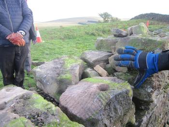
(1) Whitley Castle, fort and extramural area (NY 6949 4868): fieldwalking and test-pitting have been undertaken in and around the well-preserved fort. The erection of a new stock-proof fence north-west of the fort crossed a series of small enclosures provisionally interpreted by the field survey as possible garden plots. The systematic dismantling of a 140 m-long stretch of drystone field wall that bisects the fort recovered more than 20 fragments of small Roman querns, some joining, together with a few other Roman artefacts (fig. 8). Two more querns were discovered during wall patching at two locations nearly 100 m from the fort. All the querns are currently undergoing recording and analysis. Patterns in the distribution of certain types of architectural components, such as the more numerous large slabs of fine red sandstone close to the headquarters and commanding officer’s house, seem to reflect the character of the underlying Roman buildings. This suggests that many of the building foundations remained virtually undisturbed until the construction of the field walls in the eighteenth and nineteenth centuries.Footnote 28
A quern used in the construction of a drystone field wall at Whitley Castle.

CUMBRIA
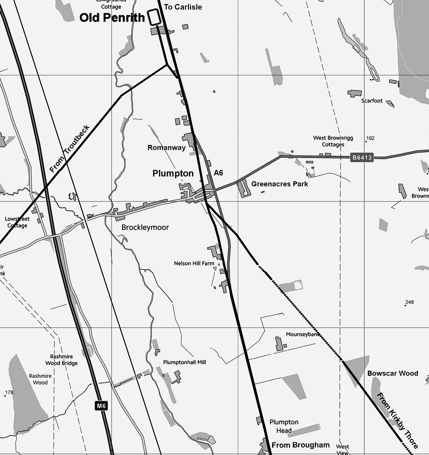
(1) Plumpton, Roman road from Kirkby Thore (NY 0897 4885): aerial photographs have revealed the likely indications of the Roman road between Kirkby Thore and Old Penrith at two locations (fig. 9), Cups Plantation (NY 54133 270) and Bowscar Wood (NY 5110 3535).Footnote 29
The Roman road arrangement south of Old Penrith fort near Plumpton.

COUNTY DURHAM
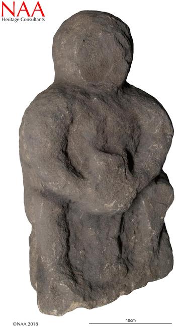
(1) Binchester (NZ 2102 3134): excavation examined a section of road seen via aerial imagery and geophysical survey that emanated from the north-east gate of the Antonine fort. The road was 5–6 m in width and was flanked in places by small areas of hard-standing which may have supported timber structures. Those on the north side of the road had subsided into the soft fill of a linear feature — possibly an infilled drainage culvert. Incorporated into the upper layer of a spread of cobbling on the south side of the road was a crude and heavily weathered carving of a Mother Goddess (fig. 10). Other items of worked stone in the vicinity hint at the former existence of a roadside shrine nearby. The cobbling had subsided into the fill of two ditches belonging to the defences of the earlier and larger Flavian fort. The base of the accompanying rampart was also partially revealed and both this and the remains of the north-east gate of the primary fort will be fully investigated in a second season of work planned for 2019.Footnote 30
A weathered carving of a Mother Goddess found incorporated into a cobble spread at Binchester.

DARLINGTON
(1) Hurworth-on-Tees (NZ 3052 1065): excavations in advance of a housing development on the northern outskirts of the modern village revealed the remains of a previously unknown Iron Age and Romano-British settlement. This lies between the two major north–south Roman roads of Dere Street and Cade’s Road, the former crossing the river Tees at Piercebridge 10 km to the west and the latter doing the same at Middleton St George 4 km to the east. At least three roundhouses of Iron Age date were identified along with the remains of a system of enclosures, the latter retained with modifications into the Roman period. A number of stone-founded buildings belonging to the Roman period were identified, the largest of which measured approximately 20 by 8 m. Contemporary features included a well and a kiln, the latter possibly used for the production of bricks and tiles. In conjunction with other recently identified sites in the vicinity, this discovery reinforces the view that the middle/lower Tees Valley was the scene of intense occupation and agricultural exploitation in the second and third centuries.Footnote 31
NORTH YORKSHIRE
(1) Aldborough, north-east of the village (SE 410 668): an excavation trench of 7 by 3 m was excavated in an area where 1924 excavations identified the remains of a structure. The excavations confirmed activity from the Flavian period, though no structural remains were identified that pre-dated the stone building constructed c. a.d. 250–300. This building was consistent in size and structure with a large warehouse; a road was located between the structure and the town wall. The building had gone out of use and was partially demolished by the later fourth century, followed by an extension and strengthening of the earthen bank behind the city wall.Footnote 32
(2) Malton, Roman fort, extramural settlement (SE 792 718): continuing work has investigated development outside the fort’s north-east gate. To the south-east of the fort’s gate, towards the river Derwent, a prestigious, timber-framed town-house with stone-tiled roof was exposed. The town-house seemingly fell out of use within the fourth century, when pits were dug through its floors. Its collapsed remains were covered by a soil horizon, itself sealed by a number of stone platforms interpreted as bases for large-scale, timber-framed buildings. These structures likely date to the fifth century or later. Beyond this lay a range of inhumations on a broadly similar alignment but with a variety of container types, body positions and grave goods, together with a stone-lined oven. A boundary ditch separated this formal settlement zone from more widely dispersed activities towards the river. In its latest incarnation, the boundary comprised a good-quality metalled roadway.
To the north-west of the road, remains of rectangular, stone-founded buildings have been uncovered, fronting that thoroughfare when adjacent but on different alignments, some 80 m away. These structures hint at artisanal functions, in contrast to the prestigious domestic activities on the opposite frontage, and were perhaps roofed with ceramic tiles. Additional fieldwork in 2019 and 2020 will generate further evidence of extramural settlement here.Footnote 33
EAST RIDING OF YORKSHIRE
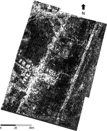
(1) Elloughton-cum-Brough, Burrs playing field (SE 9372 2687): ground penetrating radar (GPR) and resistivity survey revealed the outline of previously undiscovered structures, buildings and streets on the Burrs playing field associated with the Roman town at Brough (fig. 11).Footnote 34 Some features identified in the GPR matched those excavated by Corder in 1933–1937, particularly the line of the defences to the east of the field. Although full analysis of the results has yet to be undertaken, it is clear that some of the newly located buildings were large and impressive. A substantial road, upon which a number of buildings were aligned, ran roughly south-west to north-east across the whole length of the field, with side branches to the north. In the centre of the playing field, immediately to the east of the road, resistivity survey confirmed the presence of further buildings detected by the GPR and magnetometer surveys, which had been partially excavated by Corder.
Ground Penetrating Radar survey by David Staveley of the Burrs, Brough at c. 0.7 m depth. Note the line of the defences to the east, the road and the cluster of buildings to the south-west of the road.

Of particular note was a complex of features in the southern portion of the field, at the junction of the main road and a road running at a right angle to the west. These included a building 20 m square, comprising a series of rooms around a courtyard, at the centre of which was a substantial D-shaped structure, which, according to the GPR results, dipped towards the north. Although superficially resembling a cavea or tiered seating arrangement, at 15 m by 10 m it is rather small for a theatre. There is a possibility that it could be a bouleuterion or council chamber,Footnote 35 although these are more common in the east of the Roman Empire. In either case, both structures would have had a proscaenium. The new discoveries at the Burrs have at last provided evidence for buildings worthy of an aedile and shown that Roman Brough was far more substantial and extensive than previously supposed.Footnote 36
LANCASHIRE
(1) Burrow-in-Lonsdale, Roman fort and vicus (SD 4726 6224): evaluation of LiDAR has revealed a possible vicus on the western side of the fort situated to either side of a road leading from the fort’s west gate towards the river Lune.Footnote 37
(2) Cuerden, Cuerden Strategic Site (SD 5504 2434): excavation was undertaken in advance of a large-scale development to the south of Lostock Hall, Preston; the southernmost area, situated on slightly elevated land to the east of Stanifield Lane, contained evidence of Romano-British activity.
A section of the Roman road was exposed along the western edge of the excavation, extending north–south over a distance of 18.32 m; this formed part of the route between Wigan and Walton-le-Dale. The metalled surface measured 11.40 m in width and was constructed of rammed gravel, pebbles and bedding laid above the natural clay; a slight camber was achieved through the levelling of additional clay in the middle of the road. The roadside ditch was exposed on its eastern side containing a fragment of iron slag in its fill. The western ditch had presumably been truncated by a later enclosure ditch dug along the same alignment as the road. There is slight evidence to suggest the road persisted as a feature in the landscape; excavations on the alignment of the Roman road 1 km to the north revealed an extensive medieval agricultural landscape.
Numerous cut features were revealed to the east of the road, the most substantial being a penannular gully and contingent gullies interpreted as an enclosure ditch or roundhouse drip gully. An arrangement of post-holes grouped in the western interior of the gully may represent the outline of a structure. The putative entrance to the enclosure faced obliquely towards the road. Charcoal recovered from a terminal of the gully returned a radiocarbon date of 1863 ± 24 b.p. (a.d. 87), indicating it was infilled in the last quarter of the first century a.d.
A shallow, elongated linear depression lined with stones was uncovered between the gully and the road, possibly indicating an external working-surface or path. Post-holes and pits in the vicinity of the aforementioned features represent probable traces of contemporary activity. A pit to the south of the ring-gully produced charcoal with a radiocarbon date of 3185 ± 24 b.p. (1235 b.c.), suggesting an extended period of occupation prior to the construction of the road.
The dating of the penannular gully to the late first century a.d. suggests the road was constructed in the period leading up to the infilling of the gully, raising the possibility the road was constructed under the governorship of Gnaeus Julius Agricola.Footnote 38
GREATER MANCHESTER
(1) Manchester, Crown Street (SJ 8317 9729): an excavation targeted on nineteenth-century buildings was conducted to the south of Chester Road along the Roman route running south from the fort of Mamucium. A ditch was exposed along the southern limit of investigation sealed beneath subsoil, running north-east/south-west. The recovery of several sherds of highly abraded red-ware pottery and tile from the fill of the ditch suggests the feature is Romano-British in date. The alignment of the feature also corresponds with the gridded field-system ditches revealed in adjacent plots at Owen Street and Great Jackson Street.Footnote 39
(2) Wigan, Land Gate, Ashton-in-Makerfield (SD 5715 0119): an excavation was conducted ahead of a housing development on land to the east of the A49 along a section of the Wilderspool to Wigan (Coccium) Roman road. The road consisted of two distinct layers, the lower comprising a spread of angular sandstone blocks; the central spine of the road was achieved by a line of larger sandstone blocks. The surface of the road was formed of a compact layer of gravel, surviving only in discrete patches as a result of modern damage. Roadside ditches were present in both areas of the excavation. Stratified Roman and fourteenth-century pottery from the lower and upper fills of the ditch, respectively, attest to a prolonged use of the boundary and possibly the road until the medieval period. Samples from a buried soil horizon sealed beneath the road have been dated by radiocarbon assay to the Late Bronze Age (2856 ± 28 b.p.; 906 b.c.).Footnote 40
CHESHIRE
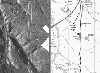
(1) Huntington, probable Roman road from Chester to Aldford and possible Roman fort (SJ 426 636): LiDAR has produced some evidence for a road in the Huntington area to the east of the river Dee going via Boughton and Huntington to Aldford (fig. 12). South from Huntington to Alford the modern road has straight sections and probably represents the route, but it does wander off line in several sections enabling the original Roman course to be located with the LiDAR imagery.
LiDAR image and modern map showing the probable Roman road on the east bank of the river Dee at Huntington, south of Chester. Also visible is the site of the possible Roman fort spotted whilst tracing this road.

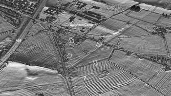
LiDAR has also revealed what appears to be a previously unknown Roman fort beside the road and respecting its orientation. This site was unrecognised despite a prominent pipeline having been inserted through it, probably in the late 1970s. The orientation of the fort respects the Roman road, and its features are more akin to a fort than a temporary camp. A second rectangular feature south of the putative fort that also respects the alignment of the road was noted (fig. 13). North of the fort is the Roman settlement at Saighton Camp, though the relationship with the fort is uncertain.Footnote 41
Oblique (3D) LiDAR image showing the site of a possible Roman fort at Huntington, south of Chester near Saighton Camp. A modern pipeline has been constructed through the site. A second rectangular feature that also respects the alignment of the road is marked with a ‘?’.

LINCOLNSHIRE
(1) Stallingborough, Stallingborough Interchange (TA 19581 12842): a second phase of evaluation was carried out following the 2017 discovery of a Roman settlement with stone buildings and associated evidence for malting. Large pottery assemblages were recovered from enclosure ditches and two distinct phases of deposition were identified; an early phase (first to second century a.d.) and a slightly later phase (third century a.d.). Features to the west of the main settlement site largely comprised ditches, although pits and post-holes were also present. Finds from these features were sparse, signifying a shift away from the focus of activity. Evidence of industrial activity was identified in a separate area to the east of the settlement and included further evidence for possible malting. It is suggested that this Roman settlement and its associated industries could have acted as an estate centre from which other settlements were managed.Footnote 42