INTRODUCTION
Vegetation cover is one of the primary metrics used to organize our understanding of regional and global ecosystems. Spatial variations in vegetation cover are typically due to broadscale climate and environmental gradients, including temperature and moisture availability (Allen and Breshears, Reference Allen and Breshears1998). Current and future anthropogenic climate changes are expected to alter vegetation cover patterns (Allen and Breshears, Reference Allen and Breshears1998; Foley et al., Reference Foley, Levis, Costa, Cramer and Pollard2000; Sun et al., Reference Sun, Song, Mu, Gao, Wang and Zhao2015), particularly near ecotonal boundaries. One particularly sensitive boundary is the prairie–forest ecotone (PFE) in central North America, a region that extends from southeast Manitoba (Canada) through the American Midwest. This ecotone occurs at the transition between the semiarid tall-grass prairie and humid boreal forests in northwest Ontario and northern Minnesota and the mesic deciduous forests of southern Minnesota and elsewhere in the United States (Umbanhowar et al., Reference Umbanhowar, Camill, Geiss and Teed2006). Projections from earth system models (ESMs) suggest that temperatures in the PFE of northwest Ontario will increase by ~3°C by 2050 and by ~5°C by 2100 and will likely be accompanied by declines in annual precipitation (Chiotti and Lavender, Reference Chiotti, Lavender, Lemmen, Warren and Lacroix2008; Price et al., Reference Price, Alfaro, Brown, Flannigan, Fleming, Hogg and Girardin2013; IPCC, Reference Pachuari and Meyer2014). As the location of the PFE is determined by moisture availability (Amiro et al., Reference Amiro, Stocks, Alexander, Flannigan and Wotton2001; Price et al., Reference Price, Alfaro, Brown, Flannigan, Fleming, Hogg and Girardin2013; Gauthier et al., Reference Gauthier, Bernier, Kuuluvainen, Shvidenko and Schepaschenko2015) and vegetation–fire interactions (Danz et al., Reference Danz, Frelich, Reich and Niemi2013), these climate projections suggest that future eastward movement of the PFE will result in displacement of the boreal forest over the coming century.
Properly projecting and understanding the effects of future climate change in this region is difficult without assessing the long-term sensitivity and natural variability of the PFE (Umbanhowar, Reference Umbanhowar2004; Nelson and Hu, Reference Nelson and Hu2008). In the absence of direct long-term climate measurements, proxy records can be used to understand the response of ecotonal regions to climate change. A past analog for future climate warming is the Holocene Thermal Maximum (HTM; Renssen et al., Reference Renssen, Seppa, Heiri, Roche, Goosse and Fichet2009, Reference Renssen, Seppa, Crosta, Goosse and Roche2012; Price et al., Reference Price, Alfaro, Brown, Flannigan, Fleming, Hogg and Girardin2013), a period of warmer than current climate conditions that occurred asynchronously across North America during the early and middle Holocene (Ritchie et al., Reference Ritchie, Cwynar and Spear1983; Bond et al., Reference Bond, Kromer, Beer, Muscheler, Evans, Showers, Hoffman, Lotti-Bond, Hajdas and Bonani2001; Viau et al., Reference Viau, Gajewski, Sawada and Fines2006; Carlson et al., Reference Carlson, LeGrande, Oppo, Came, Schmidt, Anslow, Licciardi and Obbink2008; Viau and Gajewski, Reference Viau and Gajewski2009; Renssen et al., Reference Renssen, Seppa, Heiri, Roche, Goosse and Fichet2009, Reference Renssen, Seppa, Crosta, Goosse and Roche2012). Although forcing mechanisms differ between current anthropogenic and past HTM warming, ESMs hindcast maximum Holocene temperature excursions similar in magnitude to projections of future anthropogenic warming (up to ~4.5°C) for the boreal region of northwest Ontario (Renssen et al., Reference Renssen, Seppa, Heiri, Roche, Goosse and Fichet2009, Reference Renssen, Seppa, Crosta, Goosse and Roche2012; Price et al., Reference Price, Alfaro, Brown, Flannigan, Fleming, Hogg and Girardin2013).
Vegetation responses to middle Holocene warmth have been well studied across the northern Great Plains and the boreal forest (Webb et al., Reference Webb, Cushing and Wright1983; Camill et al., Reference Camill, Umbanhowar, Teed, Geiss, Aldinger, Dvorak, Kenning, Limmer and Walkup2003; Wright et al., Reference Wright, Stefanova, Tian, Brown and Hu2004; Nelson and Hu, Reference Nelson and Hu2008; Williams et al., Reference Williams, Shuman, Bartlein, Diffenbaugh and Webb2010; Moos and Cumming, Reference Moos and Cumming2011; Commerford et al., Reference Commerford, Leys, Mueller and McLauchlan2016; Marsicek et al., Reference Marsicek, Shuman, Bartlein, Shafer and Brewer2018; Routson et al., Reference Routson, McKay, Kaufman, Erb, Goosse, Shuman, Rodysill and Ault2019), where major shifts in the PFE have been detected over the early and middle Holocene. This includes the rapid increase of non-arboreal prairie pollen taxa between 10,000 and 8000 cal yr BP and the eastward expansion of prairie taxa between ~8000 and 4000 cal yr BP in the American Great Plains (Webb et al., Reference Webb, Cushing and Wright1983; Camill et al., Reference Camill, Umbanhowar, Teed, Geiss, Aldinger, Dvorak, Kenning, Limmer and Walkup2003; Wright et al., Reference Wright, Stefanova, Tian, Brown and Hu2004; Williams et al., Reference Williams, Shuman and Bartlein2009; Commerford et al., Reference Commerford, Leys, Mueller and McLauchlan2016). Records from northwest Ontario also suggest eastward movement of the PFE during the early or middle Holocene (McAndrews, Reference McAndrews1982; Björck, Reference Björck1985), but well-dated sediment cores to track the movement of the PFE over finer spatial and temporal scales are lacking. Previous pollen-derived climate reconstructions suggest that the boreal region experienced increases in both average temperature and evapotranspiration between ~8000 and ~4500 cal yr BP (Moos and Cumming, Reference Moos and Cumming2011).
There are few studies on northern PFE dynamics adjacent to the Canadian prairies. Therefore, the first objective of this article is to examine the movement of the PFE over a fine spatial scale across the boreal region of northwest Ontario using new pollen records. The second objective of this paper is to reexamine nearshore diatom assemblages in combination with these new pollen data and climate reconstructions to better interpret previous assessments of regional lake-level changes across northwest Ontario during the middle Holocene (Laird and Cumming, Reference Laird and Cumming2008; Moos et al., Reference Moos, Laird and Cumming2009; Karmakar et al., Reference Karmakar, Laird and Cumming2015). In this paper, we build upon the well-dated and quantitatively reconstructed Holocene pollen record of Moos and Cumming (Reference Moos and Cumming2011) by examining Holocene pollen records for two additional sites in the boreal forest region of northwest Ontario that also have well-described diatom records (Moos et al., Reference Moos, Laird and Cumming2009; Karmakar et al., Reference Karmakar, Laird and Cumming2015). Together, these three sites form a west-to-east transect that can be used to understand the sensitivity of boreal forests (near the PFE) to changes in climate over the Holocene.
METHODS
Study sites and regional context
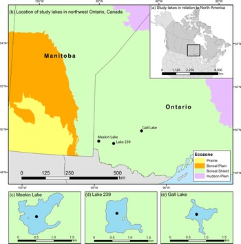
Meekin Lake (78 ha) and Gall Lake (19 ha) are two small lakes in the Winnipeg River Drainage Basin (WRDB) located in the boreal forest region of northwest Ontario, Canada (Fig. 1). Together with IISD-ELA Lake 239 (hereafter referred to as Lake 239; 56 ha; Moos and Cumming, Reference Moos and Cumming2011), located between Meekin Lake and Gall Lake, the three study lakes form a west-to-east transect through the boreal forest east of the Canadian prairies and northern PFE. Geologically, these lakes lie within the metamorphosed Precambrian granites and granodiorites of the Boreal Shield. Soils are shallow, poorly drained, and moss-covered (Moos and Cumming, Reference Moos and Cumming2011; Kingsbury et al., Reference Kingsbury, Laird and Cumming2012). As these sites are headwater lakes with small drainage areas, they are more responsive to climate changes than lakes with larger drainage basins and/or riverine inputs (e.g., Webster et al., Reference Webster, Kratz, Bowser, Magnuson and Rose1996; Ala-aho et al., Reference Ala-aho, Rossi and Kløve2013). Meekin Lake is located ~100 km east of the modern-day PFE (Fig. 1), within the western portion of the WRDB. Vegetation surrounding Meekin Lake primarily comprises mixed-wood trees, including Populus spp. (poplar), Fraxinus nigra (black ash), Betula papyrifera (white birch), Acer rubrum (red maple), and Abies balsamea (balsam fir; Kingsbury et al., Reference Kingsbury, Laird and Cumming2012). Gall Lake is ~350 km east of the modern-day PFE (Fig. 1), within the eastern region of the WRDB. Vegetation cover surrounding Gall Lake primarily comprises coniferous species including Picea mariana (black spruce), Pinus banksiana (jack pine), A. balsamea, and Larix spp. (larch; Kingsbury et al., Reference Kingsbury, Laird and Cumming2012). The vegetation cover of Lake 239 is well described in Moos and Cumming (Reference Moos and Cumming2011). The catchments of all three lakes are minimally disturbed by anthropogenic activities (Kingsbury et al., Reference Kingsbury, Laird and Cumming2012). The limnological characteristics of the study lakes have previously been described in Kingsbury et al. (Reference Kingsbury, Laird and Cumming2012) but are provided in Supplementary Table 1.
Maps of the three study sites indicating the location of the study region (marked by the rectangle), in relation to North America (a); the location of the three study sites (Meekin Lake, Lake 239, and Gall Lake) in northwest Ontario along a west-to-east spatial transect from ~100 to 350 km from the present-day prairie–forest ecotone (b); and coring locations indicated (by a circle) for Meekin Lake (c), Lake 239 (d), and Gall Lake (e). Maps were made at Queen's University. References for ecotone layers: (1) http://sis.agr.gc.ca/cansis/nsdb/ecostrat/gis_data.html; (2) http://sis.agr.gc.ca/cansis/nsdb/ecostrat/index.html.

Meekin Lake, Lake 239, and Gall Lake all experience a humid continental climate (Köppen Dfb) with hot summers and long, cold winters. Records of mean annual temperature and precipitation from Kenora, Ontario (~22 km southeast of Meekin Lake and ~50 km west of Lake 239), and from Sioux Lookout, Ontario (~20 km southeast of Gall Lake), are available beginning in the early 1900s. Mean annual temperature in Kenora (Meekin Lake and Lake 239) was ~2.4°C between 1961 and 1990, while mean annual temperature in Sioux Lookout (Gall Lake) was ~1.2°C between 1961 and 1990 (Environment Canada; https://climate.weather.gc.ca).
Field sampling and pollen preparation
Sediment cores were retrieved from the central basin of Meekin Lake (coring depth = 15 m; 49°49′4.7″N, 94°46′15″W) and Gall Lake (coring depth = 16.5 m; 50°11′2.2″N, 91°41′57.9″W) in June 2011 using a 1 m Livingston square-rod piston corer with an internal diameter of 5.1 cm (Wright, Reference Wright1967; Glew et al., Reference Glew, Smol, Last, Last and Smol2001). The piston cores were extruded horizontally directly on the coring platform. The cumulative lengths of the cores were ~9 m and ~5 m for Meekin Lake and Gall Lake, respectively, while the Lake 239 core was ~11 m long (see Moos and Cumming, Reference Moos and Cumming2011). All cores were wrapped as 1 m sections and transported to the Paleoecological Environmental Assessment and Research Laboratory (PEARL) at Queen's University for storage (at ~4°C) and analysis. Core sections were halved; one half was archived, and the other half was sectioned into 0.5 cm intervals for geochronological and palynological investigation.
Sediment intervals for Meekin Lake and Gall Lake were chosen to approximately correspond with the temporal resolution of the Lake 239 core from Moos and Cumming (Reference Moos and Cumming2011; ~230 yr). Subsamples (~1.0 cm3) taken at regularly spaced intervals (every 16 cm) were processed following a modified procedure for lacustrine pollen (e.g., Matsuoka and Fukuyo, Reference Matsuoka and Fukuyo2000; Bennett and Willis, Reference Bennett, Willis, Smol, Birks and Last2001). Briefly, two tablets containing a known number of Lycopodium clavatum spores (batch no. 124961) were added to samples to facilitate the calculation of pollen concentrations and accumulation rates (Stockmarr, Reference Stockmarr1971). Carbonates in the samples were dissolved using warm 10% HCl. A weakly basic solution of 0.02% Calgon was used to deflocculate clay-rich samples from the bottom of each core. All other chemical processing typical in pollen preparations (i.e., HF, acetolysis, KOH) were omitted to ensure the integrity of non-pollen palynomorph fossils (Mertens et al., Reference Mertens, Verhoeven, Verleye, Louwye, Amorim, Ribeiro and Deaf2009; Riddick et al., Reference Riddick, Volik, McCarthy and Danesh2016) that were also analyzed from these samples (Danesh et al., unpublished data). Samples were sieved after each step using a 5 μm Nitex mesh, and the material retained on the sieve was backwashed, retained, and mounted on slides with glycerin jelly. A minimum of 600 pollen grains were counted and identified per slide at 400× magnification and using taxonomic references, including Kapp et al. (Reference Kapp, Davis and King2000) and McAndrews et al. (Reference McAndrews, Berti and Norris1973).
Geochronology
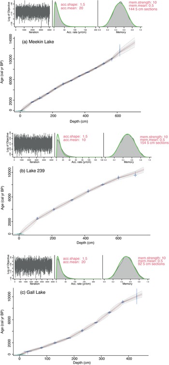
Detailed information regarding processing of 14C dates can be found in Moos et al. (Reference Moos, Laird and Cumming2009) and Karmakar et al. (Reference Karmakar, Laird and Cumming2015), but in brief, accelerator mass spectrometry (AMS) 14C ages were estimated from pollen grains, isolated at LacCore (University of Minnesota) using the procedures modified from Brown et al. (Reference Brown, Nelson, Mathewes, Vogel and Southon1989), and analyzed at Lawrence Liverpool National Laboratory. The age–depth models developed for Meekin Lake, Lake 239, and Gall Lake were based on 12, 7, and 9 AMS dates, respectively (Table 1). The age–depth models for all three study lakes have been previously published using linear age–depth modeling with the CLAM package (Blaauw, Reference Blaauw2010) in R for Meekin Lake and Gall Lake (Karmakar et al., Reference Karmakar, Laird and Cumming2015) or by polynomial regression for Lake 239 (Moos et al., Reference Moos, Laird and Cumming2009). To ensure robust and consistent geochronologies in all three study lakes, new Bayesian age–depth models were developed for each core using the rBACON (v. 2.5.6) package in R (Blaauw and Christen, Reference Blaauw and Christen2011; R Core Team, 2020. The models were constructed using the IntCal20 calibration curve (Reimer et al., Reference Reimer, Austin, Bard, Bayliss, Blackwell, Bronk Ramsey and Butzin2020) with default distribution and accumulation rate settings outlined by Goring et al. (Reference Goring, Williams, Blois, Jackson, Paciorek, Booth, Marlon, Blaauw and Christen2012). Default settings were also used for the prior memory. Surface ages used for the models were based on the correspondence between age estimates on the piston cores to measured activities of 210Pb and 137Cs of gravity cores that were extruded vertically and dated using a constant rate of supply model (Meekin Lake: −45 cal yr BP for the 3–4 cm interval; Gall Lake: −27 cal yr BP for the 2.5–3 cm interval; Lake 239: −8 cal yr BP for the 2.5–3 cm interval; Moos and Cumming, Reference Moos and Cumming2011; Karmakar et al., Reference Karmakar, Laird and Cumming2015).
Summary of the 14C ages based on isolated pollen grains from selected intervals of Meekin Lake, Lake 239, and Gall Lake cores.

a The calibrated ages (cal yr BP) are based on the weighted averages of the probability distribution obtained via the rBACON (v. 2.5.6) modeling package in R. Data is from Moos et al. (Reference Moos, Laird and Cumming2009) and Karmakar et al. (Reference Karmakar, Laird and Cumming2015).
Data visualization and numerical analysis
All pollen types that occurred at >5% abundance in at least one sample were graphed, while all other types comprising 2%–5% relative abundance were grouped into larger categories (i.e., other deciduous trees and other herbs and shrubs). Pollen types <2% were not included in the analysis. Pollen sums were based on arboreal and non-arboreal taxa, with the inclusion of some aquatic taxa that were not abundant (Lemna spp. (duckweed), Typha spp. (cattail), Sagittaria spp. (arrowhead), Triglochin spp. (arrowgrass)). To directly compare vegetational changes across study lakes, only pollen data younger than ~10,000 cal yr BP were plotted. All plots were made using the program C2 (Juggins, Reference Juggins2007). Stratigraphically constrained cluster analysis (CONISS; Grimm, Reference Grimm1987) was performed using the computer program Tilia (v. 2.6.1; Grimm, Reference Grimm2004) on square-root-transformed pollen abundance data for each core to delineate major vegetational zones throughout the Holocene.
Reconstructions of mean annual temperature (MAT) and evapotranspiration (ET) were estimated from fossil pollen records using the modern analog technique and the training set and parameters described in Moos and Cumming (Reference Moos and Cumming2011). Reconstructions of MAT and ET were based on 387 modern sites subsampled from the larger North American modern pollen database (Whitmore et al., Reference Whitmore, Gajewski, Sawada, Williams, Shuman, Bartlein and Minckley2005; Williams et al., Reference Williams, Shuman, Bartlein, Whitmore, Gajewski, Sawada and Minckley2006, v. 1.7) to form a regional calibration data set appropriate for these lakes (for specifics, see Moos and Cumming, Reference Moos and Cumming2011). Squared-chord distances were used as similarity metrics for reconstructions based on the five nearest unweighted analogs for each fossil sample (Overpeck et al., Reference Overpeck, Webb and Prentice1985; Viau et al., Reference Viau, Gajewski, Sawada and Fines2006; Viau and Gajewski, Reference Viau and Gajewski2009). Model performance for average temperature (MAT) and evapotranspiration (ET) was based on bootstrapped r 2 and root-mean-squared error of prediction (RMSEP) in both of the reconstructions (MAT: r 2 boot = 0.91, RMSEP = 1.3°C; ET: r 2 boot = 0.82, RMSEP = 52 mm). All modern analog reconstructions were performed using the computer program C2 (Juggins, Reference Juggins2007).
A synthesis figure consisting of planktonic diatom data from nearshore cores from each study lake (Karmakar et al., Reference Karmakar, Laird and Cumming2015) alongside new pollen data was also plotted. Detailed information on the location and sample preparation for the diatom samples can be found in Karmakar et al. (Reference Karmakar, Laird and Cumming2015). For consistency, age–depth models for these nearshore cores were remade using the Bayesian models described above (Supplementary Fig. 3, Supplementary Table 2).
RESULTS
Geochronology
Comparison of 210Pb and 137Cs activities between the uppermost sediments from the piston cores and the adjacent gravity cores resulted in confident dates of 1958 for Lake 239 (Moos and Cumming, Reference Moos and Cumming2011), 1995 for Meekin Lake, and 1977 for Gall Lake (Karmakar et al., Reference Karmakar, Laird and Cumming2015), at the top of the piston cores. The age–depth models for the piston cores from Meekin Lake, Lake 239, and Gall Lake show simple relationships with relatively small errors, and no evidence of hiatuses in sedimentation (Fig. 2). The sediment cores represent the last ~14,000 cal yr BP (Meekin Lake), ~11,000 cal yr BP (Lake 239), and ~10,000 cal yr BP (Gall Lake). Sediment accumulation rates based on the age–depth models show only small variations throughout the sediment record of the three study lakes. Average time integration per 0.5 cm interval varies slightly among the cores (~8, 7, and 12 yr for Meekin Lake, Lake 239, and Gall Lake, respectively).
Bayesian age–depth models produced using the rBACON (v. 2.5.6) modeling package in R for Meekin Lake (a), Lake 239 (b), and Gall Lake (c) based on calibrated 14C dates (Table 1). Shaded area represents 95% confidence intervals based on 1000 iterations. Top left: Markov chain Monte Carlo model iterations; top middle: prior (line) and posterior (shaded) sediment accumulation rate distribution; top right: prior (line) and posterior (shaded) model memory distributions.

Pollen assemblages
Thirty-six pollen types were identified across the three sediment cores. Climate zones were demarcated based on the CONISS analysis described earlier.
Meekin Lake
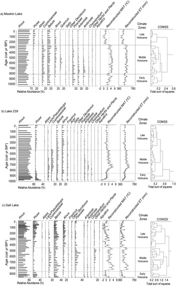
Three major vegetation zones were identified in Meekin Lake over the last 10,000 cal yr BP (Fig. 3a) and broadly correspond to the early, middle, and late Holocene. The early Holocene occurred between ~10,000 and 8300 cal yr BP and contained relatively high abundances of Pinus, and low abundances of Picea, Betula, and Cupressaceae (cypres). Reconstructed MAT and ET values were relatively low at the start of this zone but increased throughout this period. The middle Holocene occurred between ~8300 and 2700 cal yr BP and was marked by decreases in Picea and increases in Cupressaceae, Alnus (alder), Quercus (oak), Poaceae (grasses), Ambrosia (ragweed), and Artemisia (mugworth) (Fig. 3a). There were further increases in reconstructed MAT and ET that plateau during the middle Holocene (Fig. 3a). Maximum temperatures throughout this zone were ~2°C warmer than modern boreal conditions. Maximum values of non-arboreal taxa (Poaceae, Ambrosia, and Artemisia) occurred between ~7500 and 7000 cal yr BP and declined over the next several thousand years. In addition, there were small increases in Quercus abundance at ~6000 cal yr BP. Cupressaceae abundance remained at high abundances throughout the entirety of this zone. The relative abundances of Betula and Alnus were also relatively stable (Fig. 3a) through the middle Holocene. The late Holocene occurred between ~2700 and 0 cal yr BP and experienced declines in all non-arboreal pollen types and increases in Picea and Pinus (Fig. 3a). Reconstructed temperature and evapotranspiration all decreased abruptly and remained relatively low over the last ~2000 cal yr BP (Fig. 3a).
Pollen diagram showing all taxa with at least >5% relative abundance in the sediment cores of Meekin Lake (a), Lake 239 (b), and Gall Lake (c), with reconstructed mean annual temperature (MAT) and evapotranspiration (ET). Climate zones are derived based on CONISS splits. The dashed (vertical) line through the reconstructed climate variables indicates the climate normal from ~1961 to 1990 taken from the meteorological station closest to each lake (Kenora for Meekin Lake and Lake 239; Sioux Lookout for Gall Lake). Data from https://climate.weather.gc.ca/climate_normals/index_e.html.

Lake 239
The pollen record of Lake 239 is discussed in detail in Moos and Cumming (Reference Moos and Cumming2011) but merits redescription due to slight differences between the original dating model and the new Bayesian age–depth model developed in this paper. Three major vegetation zones were delineated in Lake 239 over the past 10,000 yr, in addition to a small zone before 10,000 cal yr BP that is represented by high abundances of Picea and low abundances of Pinus (Fig. 3b). During the early Holocene, ~9900 to 8500 cal yr BP, Picea declined and Pinus increased within this zone. The remaining taxa occurred at low abundances in the early Holocene. Both reconstructed climate variables increased through this zone. The middle Holocene occurred between ~8500 and 4400 cal yr BP and was characterized by increases in Cupressaceae and non-arboreal taxa (Fig. 3b). Artemisia and Ambrosia increased at the beginning of this zone but declined by ~6000 cal yr BP. Pinus and Picea both decreased in this zone. Reconstructed MAT was ~2°C warmer than modern conditions, with the highest inferred temperatures centered at ~7200 cal yr BP. This change in temperature covaried with pollen-inferred changes in reconstructed ET. The late Holocene occurred between ~4400 and 0 cal yr BP and began with declines in Cupressaceae and increases in Pinus and Picea (Fig. 3b). There were minor increases in other arboreal taxa during this time. Both reconstructed climate variables declined up to ~2000 cal yr BP (Fig. 3b).
Gall Lake
Three major vegetation zones were observed in the sediment record from Gall Lake. The early Holocene occurred from ~10,000 to 8600 cal yr BP and contained high abundances of Pinus and Picea. Relative abundances of other pollen types except Betula were low during this time. Reconstructed MAT and ET values were low in the early Holocene (Fig. 3c). There was a substantial change in pollen assemblage during the middle Holocene from ~8600 to 4500 cal yr BP. Pinus and Picea declined in relative abundance (Fig. 3c) and Betula increased. Non-arboreal pollen abundance also increased within this zone with major increases in Cupressaceae and Poaceae (Fig. 3c, Supplementary Fig. 1c). Ambrosia was present at trace abundances in the middle Holocene and declined to negligible levels by ~7000 cal yr BP. Reconstructed MAT and ET reached maximum values at ~7500 cal yr BP and then declined throughout the remainder of the zone. Reconstructed MAT is ~2°C warmer than current conditions during the middle Holocene (Fig. 3c). The late Holocene occurred between ~4500 and 0 cal yr BP and was defined by increases in Pinus up to ~3000 cal yr BP and Picea throughout the zone. Both Betula and Alnus occurred at higher abundances in the late Holocene than in previous zones. The abundances of Cupressaceae and Poaceae decreased over the late Holocene as well. Reconstructed MAT and ET decreased across the late Holocene (Fig. 3c).
DISCUSSION
Pollen records and reconstructed climate from Meekin Lake and Gall Lake show patterns similar to previously established records from Lake 239 (Moos and Cumming, Reference Moos and Cumming2011), but with considerable differences in the timing of pollen assemblage changes across the study transect. Comparisons among pollen-inferred vegetational shifts, reconstructed temperatures and evapotranspiration, and diatom-inferred lake levels (Moos et al., Reference Moos, Laird and Cumming2009; Karmakar et al., Reference Karmakar, Laird and Cumming2015) suggest three climate phases across the Holocene of northwest Ontario (Fig. 4, Supplementary Fig. 2). Broadly, these are an early Holocene cool phase with locally variable lake levels; a middle Holocene warm phase with low lake levels; and a late Holocene cool phase with relatively high lake levels. The warm and dry middle Holocene suggests an eastward expansion of the PFE, which extends previously established and generally contemporaneous PFE transitions observed to the south and west of the transect (e.g., Williams et al., Reference Williams, Shuman and Bartlein2009). Changes in the vegetation and inferred climate generally followed a spatial pattern wherein warm and dry conditions occur first in the west at Meekin Lake, followed by the eastward site (Gall Lake), before retreating several millennia later. Changes in both pollen and diatom assemblages are likely due to changes in temperature and effective moisture, which co-vary, across the Holocene throughout this region and highlight the sensitivity of this region to future changes in ecotonal boundaries.
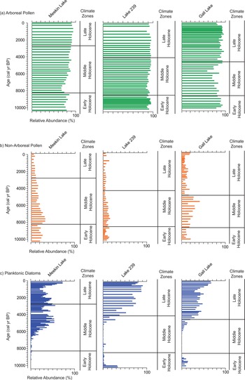
Summary diagram of arboreal pollen and non-arboreal pollen from the center basin cores and planktonic diatom abundances from the nearshore cores for: Meekin Lake (a), Lake 239 (b), and Gall Lake (c). Climate zones were derived from CONISS splits from Fig. 3.

Climate and effective moisture patterns across the Holocene in northwest Ontario
Contemporaneous increases in reconstructed temperature and evapotranspiration suggest declines in effective moisture through the early and middle Holocene of northwest Ontario. This is shown vegetatively by increases in non-arboreal taxa (e.g., Ambrosia, Artemisia, Poaceae) and associated inferences in maximum reconstructed temperatures (Fig. 3). Effective moisture is inferred to be high during the early Holocene based on the high abundances of Pinus and Picea pollen across the transect (Fig. 3). Vegetational patterns at westernmost Meekin Lake suggest relative aridity during this time in comparison to the other sites.
Effective moisture declined during the early Holocene at Meekin Lake, driven by increases in the non-arboreal taxa Poaceae and Ambrosia, as well as increases in Cupressaceae (Umbanhowar et al., Reference Umbanhowar, Camill, Geiss and Teed2006; Nelson and Hu, Reference Nelson and Hu2008; Commerford et al., Reference Commerford, Leys, Mueller and McLauchlan2016). There is considerable difficulty in interpreting Cupressaceae pollen in sedimentary records, as this taxon may represent either Juniperus (juniper) or Thuja (cedar), which are difficult to distinguish morphologically (Liu, Reference Liu1990; Yu et al., Reference Yu, McAndrews and Eicher1997). Moos and Cumming (Reference Moos and Cumming2011) consider Cupressaceae pollen to represent mainly Juniperus, based on the location of the study site, an interpretation we also make here. Increases in non-arboreal pollen, including Poaceae, Ambrosia, and Artemisia, in Meekin Lake suggest an eastward movement of the PFE as early as ~9000 cal yr BP. This pattern is generally comparable to descriptions of PFE movement to the south (Williams et al., Reference Williams, Shuman and Bartlein2009; Commerford et al., Reference Commerford, Leys, Mueller and McLauchlan2016). Low effective moisture before 6000 cal yr BP at Meekin Lake is also evident from the nearshore diatom assemblages (which suggest low lake levels before ~6000 cal yr BP due to negligible occurrences of planktonic taxa (Karmakar et al., Reference Karmakar, Laird and Cumming2015).
Lake 239 displays similar patterns in lake level during the early Holocene (Fig 4), but reconstructed temperature and evapotranspiration values are low at ~10,000 cal yr BP and do not increase until ~8000 cal yr BP, a delayed response compared with Meekin Lake (Fig. 3). Pollen data suggest that increases in temperature and declines in moisture availability are driven by increases in Cupressaceae as well as non-arboreal taxa such as Ambrosia at this site (Fig. 3b). Diatom records (Fig. 4) suggest low effective moisture and declines in lake level during the middle Holocene of Lake 239 based on the low abundance of planktonic diatoms (Moos et al., Reference Moos, Laird and Cumming2009).
At Gall Lake, low effective moisture in the middle Holocene is inferred by increases in the abundances of Poaceae and Cupressaceae between ~8000 and 5000 cal yr BP (Fig. 3). This pattern in vegetational shifts is delayed when compared with Meekin Lake (~9000 cal yr BP). The relatively high abundances of non-arboreal pollen found in Gall Lake during the middle Holocene is contemporaneous with low abundances of planktonic diatoms (Fig. 4), which suggests regionally low lake levels during this time (Karmakar et al., Reference Karmakar, Laird and Cumming2015).
Declines in non-arboreal pollen taxa and reconstructed temperature and evapotranspiration over the past ~6000 cal yr BP at both Lake 239 and Gall Lake (Fig. 3), along with increases in the abundances of planktonic diatom taxa (Fig. 4), suggest higher effective moisture levels over this time. At Meekin Lake, however, declines in non-arboreal prairie taxa are followed by increases in Quercus, which suggests a two-phased middle Holocene warm period. The first phase was warmer, with low effective moisture availability from ~9000 to 6500 cal yr BP. Increases in lake levels at Meekin Lake occur ~1000 yr earlier than at the more eastern sites (Fig. 4) and are contemporaneous with high abundances of Quercus pollen. This pattern suggests a northward movement of the semiarid oak savanna ecotype from more southerly Minnesota, as described by Commerford et al. (Reference Commerford, Leys, Mueller and McLauchlan2016), and minor increases in effective moisture at the PFE ~6000 cal yr BP (second phase). Declines in Quercus and other arboreal taxa and high abundances of non-arboreal prairie-type pollen up to ~3000 cal yr BP suggest sustained low effective moisture and a persistent eastward position of the PFE (Nelson and Hu, Reference Nelson and Hu2008; Williams et al., Reference Williams, Shuman and Bartlein2009; Commerford et al., Reference Commerford, Leys, Mueller and McLauchlan2016). The absence of these patterns at Lake 239 and Gall Lake suggests that PFE influence waned at these sites by ~4500 cal yr BP, when arboreal taxa increased. At all sites, declines in reconstructed temperatures across the late Holocene are be primarily driven by increases in Pinus and Picea, which result in relatively stable inferences of MAT and ET during the late Holocene and suggest mesic boreal conditions became established by ~2000 cal yr BP (Webb et al., Reference Webb, Cushing and Wright1983; Wright et al., Reference Wright, Stefanova, Tian, Brown and Hu2004; Umbanhowar et al., Reference Umbanhowar, Camill, Geiss and Teed2006; Nelson and Hu, Reference Nelson and Hu2008; Williams et al., Reference Williams, Shuman and Bartlein2009).
Spatial differences in vegetation dynamics across northwest Ontario
Vegetation dynamics were not spatially uniform across North America or in northwest Ontario across the Holocene. Meekin Lake, Lake 239, and Gall Lake each exhibited changes in vegetation that reflect increases in temperature and evapotranspiration during the early and middle Holocene, but with warm and dry conditions occurring earliest in the westernmost site (Meekin Lake). In addition, pollen-reconstructed climate variable maxima were asynchronous across the boreal region of northwest Ontario, with Meekin Lake experiencing the warmest conditions from ~9000 to 3000 cal yr BP and with changes at Lake 239 and Gall Lake occurring between ~8000 and 4500 cal yr BP (Fig. 3). In all cases, maximum Holocene warmth inferred from the pollen was ~2°C–3°C warmer than current conditions, similar to predictions for future warming for the region (Renssen et al., Reference Renssen, Seppa, Heiri, Roche, Goosse and Fichet2009, Reference Renssen, Seppa, Crosta, Goosse and Roche2012; Price et al., Reference Price, Alfaro, Brown, Flannigan, Fleming, Hogg and Girardin2013).
Vegetation changes and reconstructed climate conditions are broadly similar across our study transect, and lake-specific differences are likely related to the distance of the site from the PFE. This is interesting when considering the recent formal subdivision of the Holocene into distinct ages based on changes in global climate (Walker et al., Reference Walker, Head, Lowe, Berkelhammer, Björk, Cheng and Cwynar2019). Major changes in vegetation and associated climate reconstructions in this study's sites occur at ~8500 cal yr BP, close to Walker et al.'s (Reference Walker, Head, Lowe, Berkelhammer, Björk, Cheng and Cwynar2019) separation of the early and middle Holocene at ~8200 cal yr BP, due to global cooling resulting from the final collapse of the Laurentide Ice Sheet. Clear decreases in reconstructed temperature at this time, evident in Meekin Lake (Fig. 3), may be related to this collapse (Shuman et al., Reference Shuman, Bartlein, Logar, Newby and Webb2002), as reflected in co-varying changes in reconstructed evapotranspiration. Continued Holocene warming, however, appears to have quickly returned northwest Ontario to its previous conditions and then to higher temperatures characteristic of the middle Holocene. There are, however, limited vegetational changes in our records at ~4300 cal yr BP, the division proposed between the middle and late Holocene (Walker et al., Reference Walker, Head, Lowe, Berkelhammer, Björk, Cheng and Cwynar2019). Hence, these sites generally do not provide supporting evidence for this proposed division and suggest that global climate signals may not be recorded in regional vegetation records in all circumstances.
Overall, the main driver of reconstructed climate is the general proportion of arboreal versus non-arboreal pollen at each site. At all sites in this study, pollen reconstructions of maximum warmth co-varied with evapotranspiration, because these inferences were driven by increases in non-arboreal pollen abundance. This agrees with previous studies showing that the North American midcontinent experienced arid conditions during the early and middle Holocene (Viau et al., Reference Viau, Gajewski, Sawada and Fines2006; Viau and Gajewski, Reference Viau and Gajewski2009; Williams et al., Reference Williams, Shuman and Bartlein2009, Reference Williams, Shuman, Bartlein, Diffenbaugh and Webb2010; Shuman and Marsicek, Reference Shuman and Marsicek2016). Specifically, the timing of inferred aridity at Meekin Lake aligns with the known expansion of the PFE ~9000 to 3000 cal yr BP at more southern sites (Camill et al., Reference Camill, Umbanhowar, Teed, Geiss, Aldinger, Dvorak, Kenning, Limmer and Walkup2003; Nelson and Hu, Reference Nelson and Hu2008; Williams et al., Reference Williams, Shuman and Bartlein2009, Reference Williams, Shuman, Bartlein, Diffenbaugh and Webb2010), suggesting the PFE expanded farther eastward than summarized by Williams et al. (Reference Williams, Shuman and Bartlein2009). The delayed and truncated appearances of non-arboreal prairie taxa in the cores of Lake 239 and Gall Lake, however, represent the limited ability of the PFE to move farther into the boreal forest, where climate was cooler and wetter than in the western part of the transect during the early and middle Holocene (Fig. 4). The higher abundances of arboreal (e.g., Pinus) taxa at both sites throughout the HTM warm period suggest a greater degree of effective moisture at these sites in comparison to conditions at Meekin Lake. It is likely that the PFE itself did not reach either Lake 239 or Gall Lake during the period of maximum warmth, but both sites experienced drier conditions with higher abundances of non-arboreal plants (Moos and Cumming, Reference Moos and Cumming2011).
A period of high abundances of non-arboreal taxa followed by the increase in Quercus taxa at ~6000 cal yr BP suggests a two-phase HTM at Meekin Lake. A warm and arid period occurred between ~9000 and 6000 cal yr BP and was followed by a relatively wet phase that began at ~6000 cal yr BP, as marked by increases in Quercus. This two-phase HTM is less pronounced in the pollen record at Lake 239, where there is an alternation from high abundances of Artemisia and Ambrosia to Cupressaceae at ~6000 cal yr BP. Decreasing temperatures and increasing effective moisture after ~6000 cal yr BP at both Lake 239 and Gall Lake would have hindered Artemisia and Ambrosia (Grimm, Reference Grimm2001; Commerford et al., Reference Commerford, Grimm, Morris, Nurse, Stefanova and McLauchlan2018) and allowed for Cupressaceae and Poaceae to expand. The proximity of Meekin Lake to the PFE and associated increases in moisture (as inferred by higher lake levels from the planktonic diatom assemblages; Fig. 4) allowed the expansion of Quercus from Minnesota to the south (Commerford et al., Reference Commerford, Leys, Mueller and McLauchlan2016). A two-phase HTM has also been described in the boreal forest in northeast North America (Liu, Reference Liu1990; Prentice et al., Reference Prentice, Bartlein and Webb1991; Elmslie et al., Reference Elmslie, Gushulak, Boreux, Lamoureux, Leavitt and Cumming2020). Elmslie et al. (Reference Elmslie, Gushulak, Boreux, Lamoureux, Leavitt and Cumming2020) describe a warm and dry period from ~7500 to 6000 cal yr BP followed by a warm and wet period from ~6000 to 4500 cal yr BP based on the northward expansion of relatively thermophilous Pinus strobus (white pine) followed by Thuja-inferred Cupressaceae in the sedimentary record of a well-dated core from northeast Ontario (~1500 km east of our study sites). This study among others (Prentice et al., Reference Prentice, Bartlein and Webb1991; Shuman and Marsicek, Reference Shuman and Marsicek2016) suggests that moisture availability increased across eastern and central North America after ~6000 cal yr BP. Decreases in solar insolation or changes to other climate-forcing mechanisms are likely responsible for lower temperatures, decreased rates of evapotranspiration, and higher effective moisture across the mid-high latitudes of North America at ~6000 cal yr BP (Bartlein et al., Reference Bartlein, Harrison, Brewer, Connor, Davis, Gajewski and Guiot2011; Shuman and Marsicek, Reference Shuman and Marsicek2016; Marsicek et al., Reference Marsicek, Shuman, Bartlein, Shafer and Brewer2018).
In this paper, we suggest that changes in pollen assemblages across northwest Ontario are associated with the eastward shift of the PFE (Williams et al., Reference Williams, Shuman and Bartlein2009). PFE influence on vegetational response was less severe farther eastward across our transect, as the increases in abundance of non-arboreal prairie pollen taxa were delayed, lessened, and truncated in the eastern sites. Declines in the accumulation rates of the non-arboreal pollen after ~5000 cal yr BP at Meekin Lake (Supplementary Fig. 1), however, suggest ecological and/or climate changes occurred despite the sustained high abundances of these taxa. The prolonged occurrence of middle Holocene conditions at Meekin Lake could be related to changes in fire dynamics, as previous studies have described the importance of fire in the maintenance of the eastward position of the PFE (Camill et al., Reference Camill, Umbanhowar, Teed, Geiss, Aldinger, Dvorak, Kenning, Limmer and Walkup2003; Umbanhowar et al., Reference Umbanhowar, Camill, Geiss and Teed2006; Teed et al., Reference Teed, Umbanhowar and Camill2009; Williams et al., Reference Williams, Shuman and Bartlein2009). The effect of large grazing mammals on the PFE might also be a potential mechanism in maintaining the eastward-shifted PFE. Archaeological evidence suggests that the range of bison extended as far east as the IISD-Experimental Lakes Area (Lake 239) at ~5000 cal yr BP (McAndrews, Reference McAndrews1982). These mammals may have helped maintain the eastward location of the PFE during the lower temperatures and higher moisture availability after ~6000 cal yr BP through intense grazing of colonizing boreal tree species. The complex relationships between climate and moisture availability described herein, fire dynamics, the effects of wildlife, and/or other factors, likely also contributed to the location of the PFE across the Holocene.
Conclusions
The PFE moved eastward into the boreal forest during the early to middle Holocene in northwest Ontario. The eastward movement of the PFE reached Meekin Lake, our most western boreal site, at ~9000 cal yr BP, in agreement with previous studies of this ecotone (Williams et al., Reference Williams, Shuman and Bartlein2009). However, study sites located eastward showed subdued expansions of prairie-type taxa. Low moisture availability during the middle Holocene, as interpreted from regionally low lake levels, was consistent with enhanced pollen-reconstructed temperatures and evapotranspiration. Furthermore, changes in vegetation suggest two climate phases over the middle Holocene: a warm and dry period followed by a phase with higher moisture availability. The middle Holocene temperature reconstructions from the pollen data are similar in magnitude to predictions of future warming for the region (Renssen et al., Reference Renssen, Seppa, Heiri, Roche, Goosse and Fichet2009, Reference Renssen, Seppa, Crosta, Goosse and Roche2012; Price et al., Reference Price, Alfaro, Brown, Flannigan, Fleming, Hogg and Girardin2013). Using the middle Holocene warming as a near-modern analog for anthropogenic climate change in this region, an eastward shift in the modern PFE could occur in northwest Ontario in coming decades.
Supplementary material
The supplementary material for this article can be found at https://doi.org/10.1017/qua.2021.52.
Acknowledgments
The authors would like to thank Brendan Wiltse for fieldwork assistance. The authors would also like to thank C.E. Umbanhowar, an anonymous reviewer, and the associate editor (Terri Lacourse) of Quaternary Research for providing insightful comments/suggestions on the original submission that resulted in the improvement of this paper. Raw counts and associated geochronologies of each core will be submitted to the Neotoma Paleoecology Database (Williams et al., Reference Williams, Grimm, Blois, Charles, Davis, Goring and Graham2018).
Financial Support
This project was funded by a Natural Sciences and Engineering Research Council of Canada (NSERC) Discovery grant to BFC and Ontario Graduate Scholarship Program (OGS) grants to DCD.