The distribution of Indigenous groups in lowland South America and the timing and sociopolitical dynamics of their dispersal patterns have been the center of research in South American archaeology, ethnography, and linguistics for more than a century (Alconini Reference Alconini2004, Reference Alconini, Parker and Rodseth2005, Reference Alconini2016, Reference Alconini, Clasby and Nesbitt2021; Bonomo et al. Reference Bonomo, Angrizani, Apolinaire and Noelli2015; Brochado Reference Brochado and Joaquim Justiniano1984; Ferraz Gerardi et al. Reference Ferraz, Fabrício, Aragon, Reichert, de Souza and Noelli2023; Howard Reference Howard1947; Iriarte et al. Reference Iriarte, Smith, de Souza, Mayle, Whitney, Cárdenas and Singarayer2017; Lathrap Reference Lathrap1970; Nordenskiöld Reference Nordenskiöld1917; Urban Reference Urban1996). As part of the larger Tupiguaraní regional dynamics emanating from the central or southwest Amazon and dispersing through the fluvial systems, it has been noted that the “territorial expansion was matched only by that of the Inca Empire” (Alconini Reference Alconini, Clasby and Nesbitt2021:243). Alconini (Reference Alconini, Clasby and Nesbitt2021:243) further observed that the Tupiguaraní expansion centered on the “Beni-Chiquitano savannas and drier Chaco regions of southern Bolivia.” With the expansion of the Incas into the Andean foothills of southeastern Bolivia, a frontier was established between two dramatically different systems of sociopolitical organization. A complex set of “soft military” and economic relations was forged between representatives of the Inca Empire stationed in small outposts and the “belligerent Guarani-Chiriguano tribes” located to the east of the border (Alconini Reference Alconini, Parker and Rodseth2005:140–141).
Until recently, much of our information regarding the timing and nature of Tupiguaraní expansion into southeastern Bolivia was based on conjecture from ethnohistories and limited archaeological data (Myers and Esquerdo Reference Myers and Esquerdo1999). Alconini (Reference Alconini, Clasby and Nesbitt2021) synthesized available archaeological data for the region, concluding that “waves” of Guaraní groups moved into the tropical savannahs and dry Chaco regions of Bolivia from around AD 200/300 through AD 1400. Not all groups expanded geographically at this time. For example, the Arawaks of the Llanos de Mojos did not expand into the region when Guaraní groups did. We do not have an explanation for why some groups expanded and others did not, although Alconini observed that Tupiguaraní groups followed “semi-mobile lifeways . . . a predatory cosmology and an ethos that was strongly tied to warfare” (Reference Alconini, Clasby and Nesbitt2021:244–245). Perhaps the Arawaks of the Llanos were more sedentary and less warlike than the Tupiguaranís, similar to stereotypes of the Caribbean Arawaks and therefore not in the mode of predatory territorial expansion. Guaraní settlements ranged from small temporary camps to large intensively occupied villages with dense midden deposits and burials. Alconini (Reference Alconini, Clasby and Nesbitt2021:Table 13.1) identified 22 sites with Guaraní components in southeastern Bolivia.
In their review of paleoecological and archaeological data for southern Amazonia, Iriarte and colleagues (Reference Iriarte, Smith, de Souza, Mayle, Whitney, Cárdenas and Singarayer2017) concluded that the southerly expansion of elevated precipitation levels and forest cover associated with mid-to-late Holocene climate change resulted in increasing frequencies of Guaraní farming communities. They referred to “ecological opportunism” accounting for the Guaraní expansion as groups took advantage of improved farming conditions in the late Holocene. Numerous Guaraní and Proto-Tupi sites dating to 2000–1000 BP were documented in their study region of southeastern South America (Iriarte et al. Reference Iriarte, Smith, de Souza, Mayle, Whitney, Cárdenas and Singarayer2017). There is evidence for broad expansion of distinct forest types across greater Amazonia during the mid-to-late Holocene (Iriarte et al. Reference Iriarte, Smith, de Souza, Mayle, Whitney, Cárdenas and Singarayer2017:971–972). However, as noted earlier in regard to the Arawaks of the Llanos there may be cultural distinctions between groups that are important to consider when assessing migration patterns and climate change (Loponte et al. Reference Loponte, Carbonera, Schneider, Gascue, Milheira, César Pereira Santos and Campos2025).
We built on recent assessments of greater Amazonian population expansions with a specific focus on southeastern Bolivia. In paraphrasing Lathrap, DeBoer (Reference DeBoer, Clasby and Nesbitt2021:271) noted that “languages, pottery styles, and peoples tended to stick together as they trekked or paddled across Amazonia.” The precise relationships between the “threesome” may vary spatially and temporally but as “a package [they tended to be] passed on across generations” (DeBoer Reference DeBoer, Clasby and Nesbitt2021:271). In discussing our findings dating from around 900 BC to AD 1600 we follow Alconini’s framing of the Tupiguaraní Tradition or, regarding pottery specifically, ceramica guaraní (Alconini Reference Alconini, Alconini and Betacourt2015:133).
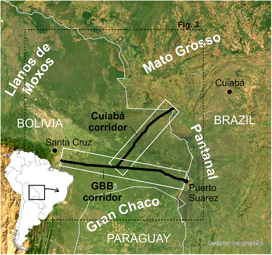
Results from archaeological surveys conducted in advance of two pipeline projects will be presented: (1) the Gas TransBoliviano (GBB) pipeline stretching from the Rio Grande, located 70 km southwest of Santa Cruz de la Sierra to the Brazilian border 12 km south of Puerto Suarez and (2) the Gas OrienteBoliviano (GOB) pipeline that originated in the Chaco region near the San Miguel River and continued in a north-northeast direction, through the provinces of Cordillera, Chiquita, and Angel Sandoval all in the Department of Santa Cruz before passing into Brazil near San Mathias (Figures 1 and 2). Results of both surveys were detailed in two limited-distribution compliance reports, and this article summarizes the major findings (Myers and Esquerdo Reference Myers and Esquerdo1999; Myers et al. Reference Myers, Esquerdo, Muñoz, Camacho, Siegel and Bienenfeld2001).
Southeastern Bolivia showing the two pipeline corridors. (Color online)

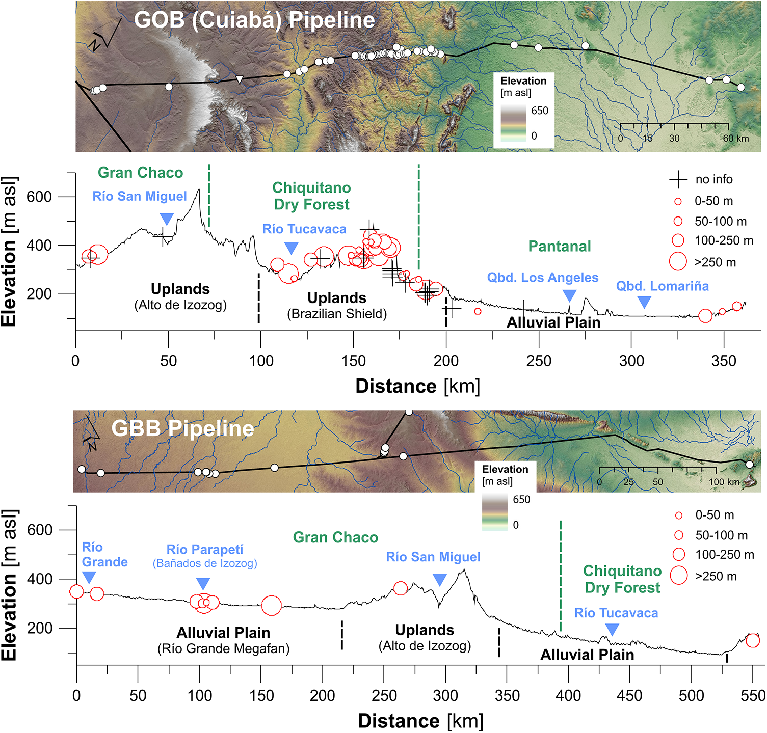
Cross-sections of the rights-of-way showing the topographic settings of identified sites. Most sites along the Cuiabá pipeline are concentrated in the Chiquitano Dry Forest. (Color online)

This article is divided into five sections: (1) review of archaeology in southeastern Bolivia, (2) discussion of the Holocene landscapes in southeastern Bolivia, (3) survey methods followed in the pipeline rights-of-way, (4) results, and (5) regional implications of the results.
Southeastern Bolivia in South American Archaeology
Southeastern Bolivia is of pivotal significance for South American precontact cultural history and the dynamics of cultural interactions, especially given its location at the interface between the Andes and Amazonia. Early studies presented arguments for what was happening in lowland versus highland cultural dynamics based on competing visions of South American precontact history, observations of ethnohistorically/ethnographically documented groups, and primacy of highland versus lowland cultures (Brochado Reference Brochado and Joaquim Justiniano1984; Lathrap Reference Lathrap1970; Meggers Reference Meggers1971; Métraux Reference Métraux and Steward1948a, Reference Métraux and Steward1948b).
In his review of radiocarbon dates from Bolivia, Capriles (Reference Capriles2023) documented that southeastern Bolivia has been exceedingly understudied. Investigations associated with megafaunal remains in the southern Chaco region produced evidence of human occupations in the form of a “hearth, scattered burnt bones, flint flakes and ceramic artefacts” dating to 7.79–6.65 cal kya BP (Coltorti et al. Reference Coltorti, Fazia, Rios and Tito2010, Reference Coltorti, Fazia, Rios and Tito2012:56). These findings suggested that megafauna survived longer than elsewhere associated with the relatively late arrival of humans to this part of South America. Unfortunately, the remains were highly fragmented and in reworked deposits; thus, associations between megafauna, 14C dates, and artifacts are not secure. In their investigations of sediment sequences and landscape evolution in the Chaco region of the Andean piedmont, May, Zech, and Veit (Reference May, Zech and Veit2008) recovered a quartzite scraper sealed in a buried paleosol dating to about 8800 cal BP and a cluster of potsherds in an aeolian deposit with a likely maximum age of 2800 cal BP (Supplementary Material 1). Despite possible problematic contexts and associations, these data indicate that southeastern Bolivia was occupied prior to the later arrival of Tupiguaraní groups into the region.
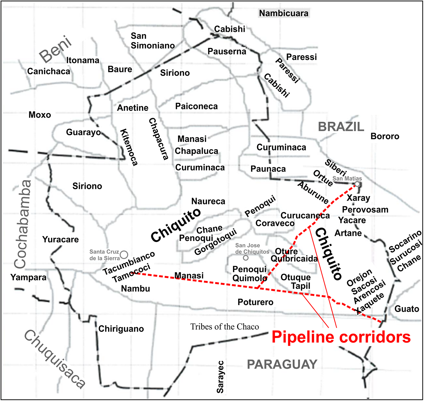
Ethnohistorically and ethnographically, the linguistic landscape of southeastern Bolivia “resembles a polyglot mosaic” (DeBoer Reference DeBoer, Clasby and Nesbitt2021:273), including Chiquitoans and affiliated tribes, Chiriguanos, Chanés, Yamparas, Sirionos, Bororos, and Ayoreos, among others (Figure 3). Like elsewhere in lowland South America, tribal entities were not static social formations but were constantly interacting, forming alliances, going to war, trading, stealing, and intermarrying (Hornborg Reference Hornborg2005; Hornborg and Hill Reference Hornborg and Hill2011). Terms like “cultural mosaic” (Wilson Reference Wilson1993), “cultural kaleidoscope” (Rivière Reference Rivière1984:102), or “kaleidoscopic mosaic” (DeBoer Reference DeBoer, Conkey and Hastorf1990:84) characterize a process of shifting cultural identities over time. Métraux’s map (Figure 3) shows a cultural mosaic at one ethnographic moment. A series of these maps for the same region over a 2,000-year period likely would show considerable blurring of boundaries through fissioning and fusioning of groups, new groups coming in, and others leaving reflecting an overall process of continuous ethnogenesis (Hornborg Reference Hornborg2005). It would be inappropriate to project specific ethnographically or ethnohistorically documented ethnic units into the precontact past without material-cultural correlates.
Southeastern Bolivia showing ethnographically documented tribes (after Métraux Reference Métraux and Steward1948b:Map 4). (Color online)

Based on archival information and some amount of fieldwork, Nordenskiöld (Reference Nordenskiöld1917:Figure 1) mapped the eastern frontier of the Inca Empire in relation to Amerindian groups in the region, the setting for the pipeline projects. Métraux (Reference Métraux and Steward1948c:468) summarized what was known about the archaeology of the Chiriguano region, describing urns and the finding of “some graves [where] the dead were seated and . . . covered with several inverted bowls.” In excavations “near Charagua” Métraux (Métraux Reference Métraux and Steward1948c:469) documented “a Chiriguano cemetery consisting of large, corrugated urns . . . identical to modern Chiriguano chicha jars, covered with smaller jars.”
More recently, three sites in Pailón near the western end of the GBB pipeline produced 22 radiocarbon dates ranging from about AD 600 to 1630 and a ceramic tradition “reminiscent of Guaraní pottery” (Alconini Reference Alconini, Clasby and Nesbitt2021:251; Prümers et al. Reference Prümers, Chevalier, Görsdorf, Hoffauer, Wagner, Wagner and Wahl2002). Alconini (Reference Alconini2004, Reference Alconini2008) has conducted excavations and ethnohistorical research in the Chaco region of southeastern Bolivia, documenting a military frontier established by the Andean-based Incas along the southeastern border of their empire. Based on pottery styles and radiocarbon dates, Alconini (Reference Alconini2004:396, Figure 2) concluded that local Yampara people inhabited the region from approximately AD 400 through the imperial Inca occupations (ca. AD 1300–1536). These local people incorporated aspects of Inca ceramic decorations and vessel shapes into their repertoire of pottery production. To the east, the Chiriguanos were included among “the Guaraní-speaking groups that extended widely across the Amazonian basin” (Alconini Reference Alconini2004:395). Pärssinen (Reference Pärssinen, Pärssinen and Korpisaari2003:87–88) suggested that Guaraní groups entered southeastern Bolivia by AD 400 and perhaps earlier based on radiocarbon dates associated with corrugated and painted ceramics. Considerable diversity has been documented in Guaraní pottery assemblages across the vast region of Tupiguaraní expansion (Alconini Reference Alconini, Clasby and Nesbitt2021:246; Noelli Reference Noelli, Silverman and Isbell2008).
Nineteenth- and early twentieth-century ethnographic accounts, information from ethnohistoric sources, and recent archaeological and environmental/geoscience studies provide a context for the current pipeline investigations. Systematic surveys and excavations conducted within the pipeline corridors add cross-sectional views into this presumed interface between the edge of the Inca empire and the “nuisance groups” of the dry tropical lowlands. In discussing the cultural occupations documented in the pipeline corridors it is important to consider shifts in the Holocene landscapes of southeastern Bolivia.
Holocene Landscapes of Southeastern Bolivia
The two pipelines cross a diverse range of landscapes that characterize the physical setting of Guaraní occupations in southeastern Bolivia (Figure 2). Southeastern Bolivia is dominated by low-relief landscapes, divided between the Cenozoic foreland basin that receives erosional products of the actively deforming Andes and the topographically elevated Andean forebulge (Horton and DeCelles Reference Horton and DeCelles2001). The foreland basin is characterized by large fluvial megafans, providing sedimentary and geomorphic evidence for dynamic channel shifts over the course of the Holocene. The Andean forebulge is covered by a spatially discontinuous veneer of Quaternary-age sediment overlying Precambrian rocks of the Brazilian Shield to the northeast and Paleozoic to Mesozoic rocks of the Izozog arch to the southeast. To the east, the region is confined by old erosional plateau landscapes of the Mato Grosso to the northeast and active wetlands of the Pantanal and Otuquis basins.
Southeastern Bolivia forms a climatic transition between the humid tropics and inundation savannahs of the Llanos de Moxos in the Bolivian Amazon basin to the north and the semiarid Gran Chaco in the south. This is expressed in the gradual decrease of total annual rainfall accompanied by increasing duration of the dry season from north to south, reflected by distinctive ecosystems across the region with Chaco dry forest in the south transitioning into semideciduous Chiquitano forest and the Pantanal Wetlands to the north-northeast (Ibisch et al. Reference Ibisch, Beck, Gerkmann, Carretero, Ibisch and Mérida2004).
Landscapes and Environments along the Pipeline Corridors
From south to north, the Cuiabá pipeline crosses portions of three major topographic zones: Gran Chaco (including the Serranía Santiago), Chiquitano Dry Forest, and Pantanal Wetlands. The west-east aligned GBB pipeline is located primarily in the Gran Chaco and only crosses the Chiquitano Dry Forest in the east near the Brazilian border (Figure 2). Human occupations in southeastern Bolivia may be viewed in the context of Holocene landscape evolution and environmental changes (Capriles Reference Capriles2023; Capriles and Albarracin-Jordan Reference Capriles and Albarracin-Jordan2013; Coltorti et al. Reference Coltorti, Fazia, Rios and Tito2010, Reference Coltorti, Fazia, Rios and Tito2012; Iriarte et al. Reference Iriarte, Smith, de Souza, Mayle, Whitney, Cárdenas and Singarayer2017; May Reference May2011; May and Veit Reference May and Veit2009; May, Argollo, and Veit Reference May, Zech and Veit2008; May, Zech, and Veit Reference May, Zech and Veit2008; May et al. Reference May, Zech, Zech, Preusser, Argollo, Kubik and Veit2011, Reference May, Cohen, Preusser, Veit, Wilkinson and Gunnell2023).
Cuiabá Pipeline. The southern end of the 360-km transect is located near the San Miguel River in the northern Chaco plains that reach the base of the Santiago range and is characterized by mixed forest and scrub vegetation. The early to mid-Holocene Chaco landscapes were characterized by arid conditions, fluvial systems with extensive sand deposits, reduced vegetation cover, and elevated levels of macroscopic charcoal indicative of greater fire frequencies (May, Zech, and Veit Reference May, Zech and Veit2008:516). The southern zone represents the northern edge of the extensive Gran Chaco that hosts much of the project area for the Gas TransBoliviano pipeline.
While the Chaco plains are extremely flat, the Serranía Santiago consists of sedimentary rock and trends NW-SE for about 100 km. Its highest point is the 1,290 m Chochis mesa. The steeply sided Serranía is flanked by flat and rolling plains filled with thick Quaternary alluvium at an elevation of about 220 m. The southern zone is drained by rivers of the Paraguay watershed (Instituto Geográfico Militar 1990). Vegetation consists of Chaco Savannas cactus and scrub forest. Areas of heavy, poorly drained soils support stands of palm trees (Trilrinax schiwphylla).
Approximately 75 km along the corridor, the pipeline enters the Chiquitano Dry Forest. The southern portion consists of Paleozoic bedrock covered by red, sandy, Quaternary alluvium. The northern portion is part of the Proterozoic craton of the Brazilian Shield and includes a system of geologically complex ridges (las pendientes) and springs. Most of the area was covered by dense semideciduous dry forest, although with deforestation beginning in the 1970s small-scale farming and ranching are common (Pinto-Ledezma and Rivero Mamani Reference Pinto-Ledezma and Mamani2014). The Chiquitano Dry Forest occupies approximately 150,000 km2 of tropical savanna, covering much of the Department of Santa Cruz from the Brazilian border to the Beni and is the largest remaining dry forest in the Americas (Ribera et al. Reference Ribera, Liberman, Beck and Morales1994). A series of streams in the zone forms a portion of the Paraguay drainage network. Soils of the central zone include 30–40 ha patches of agriculturally productive sandy to clayey loams (Killeen et al. Reference Killeen, Calderón, Soria, Quezada, Steininger, Harper, Solórzano and Tucker2007).
The humid tropical northern zone crosses the Pantanal wetlands at the headwaters of the Paraguay River. Draining the center of the northern zone, the Mercedes River flows southeast into the Paraguay River and includes fertile soils and permanent water near high ground. There is some clayey loam agriculturally productive soil along the Mercedes River, while the rest consists of compacted sandy, Quaternary alluvium, especially north of the Mercedes. The Pantanal consists of grasslands in the dryer parts, with floating vegetation in more humid locations. In some areas, vegetation is similar to the humid savannas of the Beni, characterized by extensive savannas subject to inundation, stands of palm trees, natural pastures, and isolated subhumid dry forest.
Gas TransBoliviano Pipeline. The 557 km GBB pipeline lies in the northern portion of the Gran Chaco, the continent's largest and least studied macrohabitat (Janzen Reference Janzen and Wilson1988; Prado and Gibbs Reference Prado and Gibbs1993). The corridor extends from the eastern foothills of the Andes near Santa Cruz de la Sierra to the Pantanal swampland and Lake Caceres at the Brazilian border (Figure 1). Compared to the Cuiabá corridor, the GBB is characterized by limited relief, with elevations ranging between 300 and 400 m asl for most of its length.
The pipeline starts on the Andean piedmont and crosses the Rio Grande, the major river draining a large portion of the eastern Andes. The Rio Grande has built a megafan, a large flat alluvial plain consisting of fluvial sediments distributed across the foreland basin by frequent avulsive channel shifts over time. The megafan landscape is characterized by poorly drained broad meandering floodplains without well-defined active channels but traces of abandoned channels of the Rio Grande. Periodic flooding results in areas of standing water ranging from small shallow ponds to extensive seasonal swamps. Approximately 100 km along the corridor, the Rio Parapeti drains into seasonal wetlands of the Bañados del lzozog that occupy a former channel of the Rio Grande. Further east, the corridor crosses the South American continental divide located in the uplands of the Izozog arch before descending into the vast alluvial plains and megafan of the San Miguel, Tucavaca, and Otuquis Rivers that drain toward the Paraguay River. In contrast to the highly seasonal and sediment-laden rivers in the eastern portion of the corridor, these rivers are perennial with substantial year-round flows and have more stable courses. An elevated east-to-west trough is located at the eastern end of the transect, just before the Brazilian border. This trough provides an intermittent connection between the Otuquis and Pantanal swamps, two distinct biological and hydrological systems.
Holocene Landscapes and Environmental Change
Situated at the transition between tropical-humid and subtropical semiarid ecozones, the diverse landscapes of southeastern Bolivia would have been affected by the larger-scale climatic changes over the late Quaternary and Holocene. Changes in rainfall and seasonality have generally been associated with the insolation-driven longer-term migration and mean position of the Inter-Tropical Convergence Zone (Mayle et al. Reference Mayle, Burbridge and Killeen2000). Evidence for human occupations in the eastern and northern Bolivian lowlands since at least the early Holocene adds an anthropogenic factor to interpreting changes in landscapes and ecosystems (Lombardo and Prümers Reference Lombardo and Prümers2010; Lombardo et al. Reference Lombardo, Szabo, Capriles, May, Amelung, Hutterer, Lehndorff, Plotzki and Veit2013). Although there are major gaps in our knowledge regarding the type, timing, and causes of changes in the eastern Bolivian landscapes, recent studies have explored sedimentary and geomorphic archives across the region and made use of paleobotanical evidence in adjacent regions (Mayle and Iriarte Reference Mayle and Iriarte2014). These efforts have enabled establishing a general framework of environmental change in the region.
Longer-Term Paleoenvironmental Evolution
While the Amazon Basin generally remained forested through the globally cooler Last Glacial Maximum (LGM) and late-glacial times, the rainforest-savannah ecotone was likely located north of its present position in eastern Bolivia (Mayle et al. Reference Mayle, Beerling, Gosling and Bush2004). The few studies from the semideciduous and deciduous dry forest ecozone (Chiquitano Dry Forest) suggest significant floristic or structural changes, while forest cover was largely maintained through the LGM and slightly expanded during the late glacial-Holocene transition (Mayle et al. Reference Mayle, Beerling, Gosling and Bush2004).
Paleoecological and geomorphic studies indicate an increase in aridity through the mid-Holocene starting about 8 to 9 kya (May, Zech, and Veit Reference May, Zech and Veit2008; Mayle et al. Reference Mayle, Beerling, Gosling and Bush2004) that led to the expansion of dry tropical forest (Whitney et al. Reference Whitney, Mayle, Punyasena, Fitzpatrick, Burn, Guillen and Chavez2011), more frequent and widespread fires throughout eastern Bolivia, and high sediment supply along minor river systems draining the Andean piedmont (May, Zech, and Veit Reference May, Zech and Veit2008; Mayle et al. Reference Mayle, Burbridge and Killeen2000). Although a pronounced dry season combined with increased sand supply may have resulted in significant aeolian activity during the early part of the mid-Holocene (Latrubesse et al. Reference Latrubesse, Stevaux, Cremon, May, Tatumi, Hurtado, Bezada and Argollo2012; May Reference May2013), the majority of available ages on fossil dunes is younger than 6 kya with clustering around ∼3 kya (May Reference May2013). Given the parabolic morphology of most dunes across eastern Bolivia and their spatial coupling to the fluvial system, dune activity may be indicative of sediment availability rather than representing an unambiguous indicator for aridity (May Reference May2013). Along the Andean piedmont and on the large megafans, major channel shifts and extensive sediment deposition have been dated to between 5.5 and 2 kya along the Rio Grande and 6.5 and 3 kya along the Rio Parapeti (May Reference May2013). In the Bolivian portion of the Chaco, the position of the Rio Grande appears to have been broadly stable since 2 kya while the current course of the Rio Parapeti, which terminates in the major wetlands of the Bañados de Izozog, was likely established about AD 900 (May Reference May2011). These reconstructions of channel shifts and sediment deposition suggest limited potential for older, mid to early Holocene archaeological sites across the fluvially dominated Andean foreland and highlights the temporally and spatially variable nature of hydrological resources associated with the dynamic river systems in the Andean foreland over the last 2–3 ky. The combination of meandering river channels, oxbow-lake formations, and great sediment deposits either removes or buries older archaeological sites making them difficult to find (Lathrap Reference Lathrap1968, Reference Lathrap1970:28–30, 39, 87). This geomorphological context may contribute to the preponderance of sites postdating about 900 BC documented in the current surveys (see Results section).
Late Holocene Landscape Changes
Paleoecological data from locations to the north and east of the pipeline corridors provide evidence for rainforest expansion since 2–3 kya, suggesting climatically driven increases in annual precipitation, reduced length of the dry season associated with a strengthened Southern American Monsoon System, and generally more stable landscapes characterized by soil formation (May and Veit Reference May and Veit2009; Mayle et al. Reference Mayle, Burbridge and Killeen2000; Plumpton et al. Reference Plumpton, Mayle and Whitney2020; Taylor et al. Reference Taylor, Horn, Mora, Orvis and Cooper2010; Whitney et al. Reference Whitney, Dickau, Mayle, Soto and Iriarte2013). While this scenario broadly characterizes late Holocene landscape evolution and suggests increasing availability of water resources along the pipeline transects, recent studies highlighted shorter-term environmental changes in eastern Bolivia related to such globally relevant climate phenomena as the Medieval Climate Anomaly (ca. AD 900–1100) and the Little Ice Age (AD 1500–1850; Apaéstegui et al. Reference Apaéstegui, Cruz, Vuille, Fohlmeister, Espinoza, Sifeddine and Strikis2018). Although the atmospheric mechanisms for these two periods differ substantially, speleothem data indicate increased convective activity over much of the eastern Andes likely leading to wetter conditions in the lowlands. Increased sedimentary dynamics since AD 1000 have also been inferred from renewed aeolian activity (May and Veit Reference May and Veit2009) and alluvial sedimentation (May, Zech, and Veit Reference May, Zech and Veit2008) along the Andean piedmont in the Chaco. Natural environmental drivers for these changes need to be interpreted with caution as recent paleoecological studies have documented anthropogenic impacts on vegetation patterns in eastern Bolivia through low-intensity human-caused fires (Maezumi et al. Reference Maezumi, Power, Mayle, McLauchlan and Iriarte2015, Reference Maezumi, Whitney, Mayle, de Souza and Iriarte2018; Mayle and Iriarte Reference Mayle and Iriarte2014; Whitney et al. Reference Whitney, Dickau, Mayle, Soto and Iriarte2013). Maize pollen and elevated charcoal counts indicate human-modified landscapes for agricultural purposes (Maezumi et al. Reference Maezumi, Whitney, Mayle, de Souza and Iriarte2018). Late Holocene expansion of tropical forest and increasing availability of hydrological resources may have been a major driver behind the agricultural expansion of Guaraní forest-farming cultures across and beyond the region traversed by the pipeline transects (Iriarte et al. Reference Iriarte, Smith, de Souza, Mayle, Whitney, Cárdenas and Singarayer2017).
Methods of Field Investigations
Field investigations for archaeological heritage-management projects are typically carried out in stages. For the pipelines, teams of archaeologists worked with engineering and clearing crews during ground preparation and trenching for the pipe. Fieldwork and laboratory analyses were conducted in consultation with the Bolivian cultural authorities in Santa Cruz and La Paz. Artifact collections now reside in Santa Cruz. Stage 1 archaeological fieldwork consisted of surface surveys following removal of the impenetrable vegetation that characterizes xerophytic tropical deciduous and semideciduous forests. Artifact concentrations or other surficial indications of archaeological remains were flagged for follow-up assessments by survey crews.
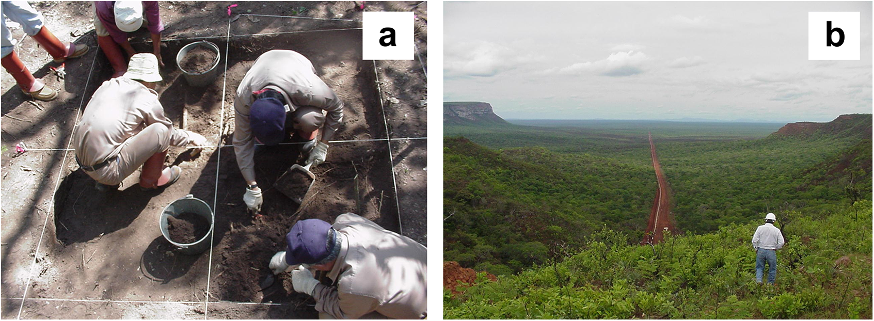
Assessments consisted of shovel testing on 5 m grids combined with surface inspections for additional information on artifact distributions and features. Shovel testing was occasionally conducted outside of the right-of-way to gain supplementary information on site size. If the assessment survey produced evidence for potentially significant archaeological resources then 1 × 1 m units were excavated in contiguous block configurations to collect additional information (Figure 4a). Based on artifact distributions, linear site sizes were estimated within the 30 m wide right-of-way. Because investigations were limited primarily to the right-of-way, linear site dimensions should be treated as minimal approximations of site size. Some sites consisted of small, localized artifact scatters with no size recorded.
(a) 2 × 2 m excavation unit and (b) view of the Chiquitano Dry Forest. Photographs by Peter E. Siegel. (Color online)

Results
Cuiabá Pipeline
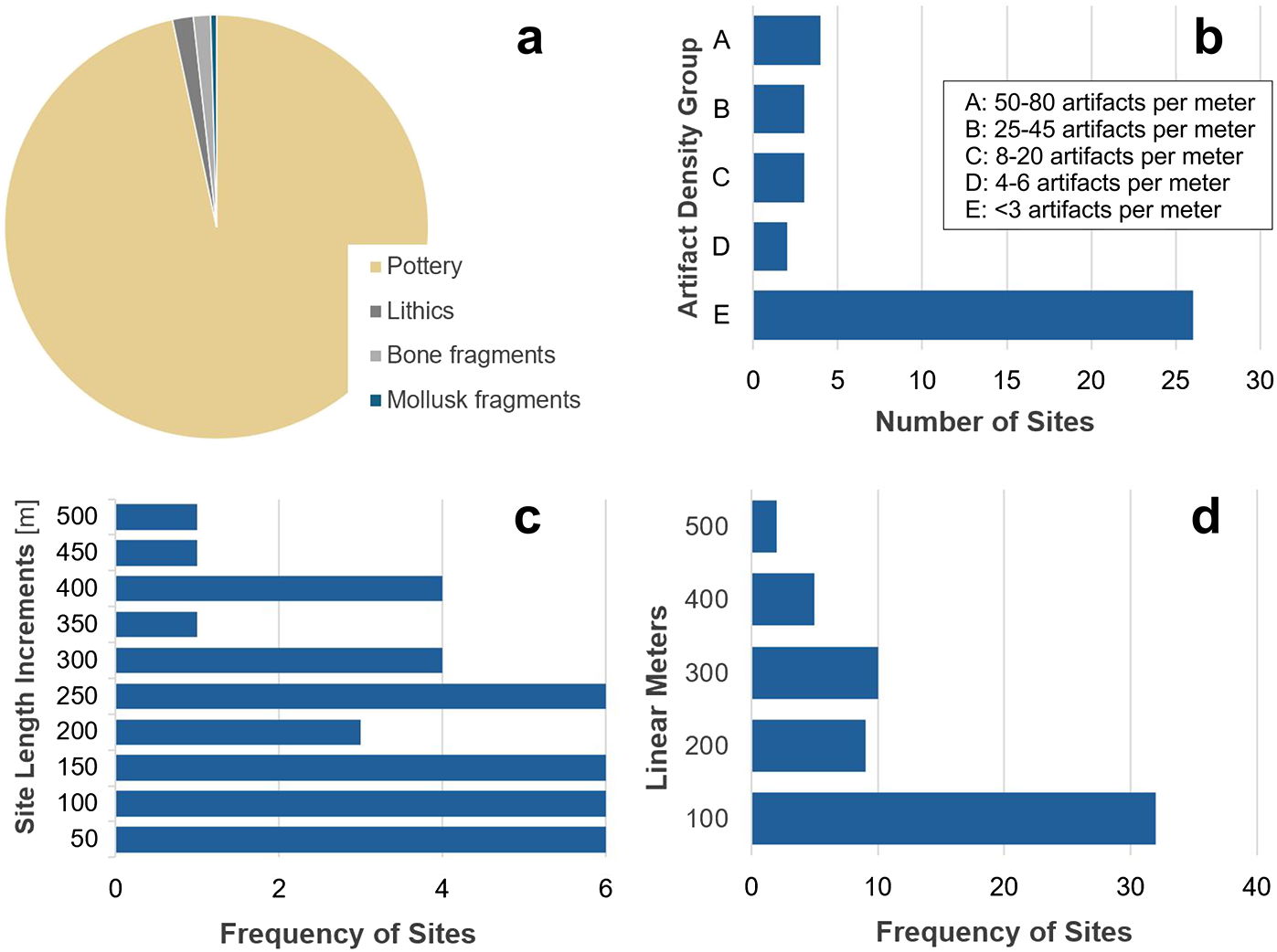
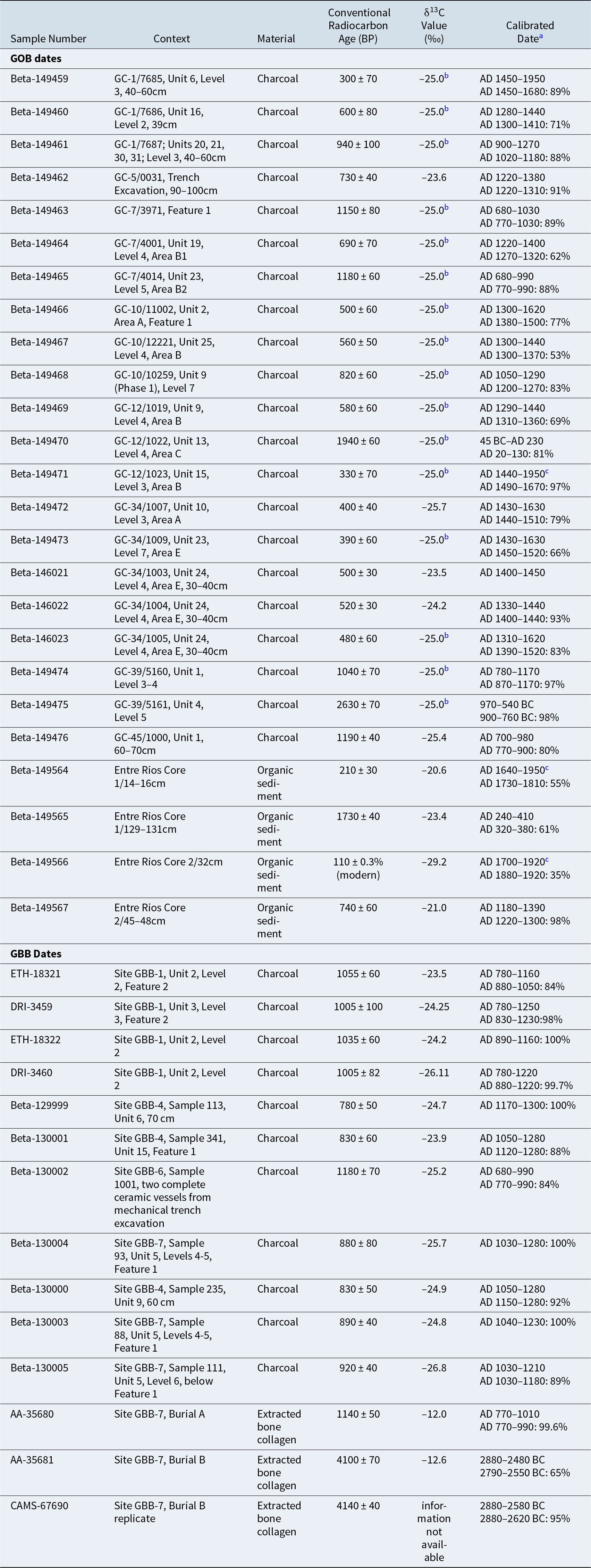
The 360 km Cuiabá survey resulted in 58 archaeological sites and 114,000 artifacts (2,200 kg). Precontact pottery accounted for the majority of the artifacts, followed by lithics, bone fragments, and mollusk fragments (Figure 5). Pottery was characterized by paste and fabric properties, vessel form, and surface decoration. Out of more than 110,000 sherds, 12,000 (9.2%) had distinctive features of surface treatment or vessel morphology that were useful for making regional comparisons. Twenty-five radiocarbon dates were obtained (Table 1). Two wetland sediment cores were collected from the southern end of the project corridor for paleoenvironmental reconstruction. In addition, archaeobotanical, zooarchaeological, human osteological, and oral history and ethnographic studies were conducted (Myers et al. Reference Myers, Esquerdo, Muñoz, Camacho, Siegel and Bienenfeld2001).
Artifact frequencies/site sizes in the Cuiabá corridor: (a) relative distribution of artifacts from Cuiabá-corridor sites; (b) Cuiabá sites by artifact density groups; (c) Cuiabá sites by 50-linear-meter size increments; (d) Cuiabá sites by 100-linear-meter size increments reveals a bimodal distribution: large versus small sites. (Color online)

Project Radiocarbon Dates.

a Dates calibrated using CALIB 8.1.0 (Reimer et al. Reference Reimer, Austin, Bard, Bayliss, Blackwell, Ramsey and Butzin2020). First range is 2σ. Second range shows the greatest probability for the actual date within the 2σ range.
b Estimated ratio.
c Ranges suspect due to impingement on the end of the calibration dataset.
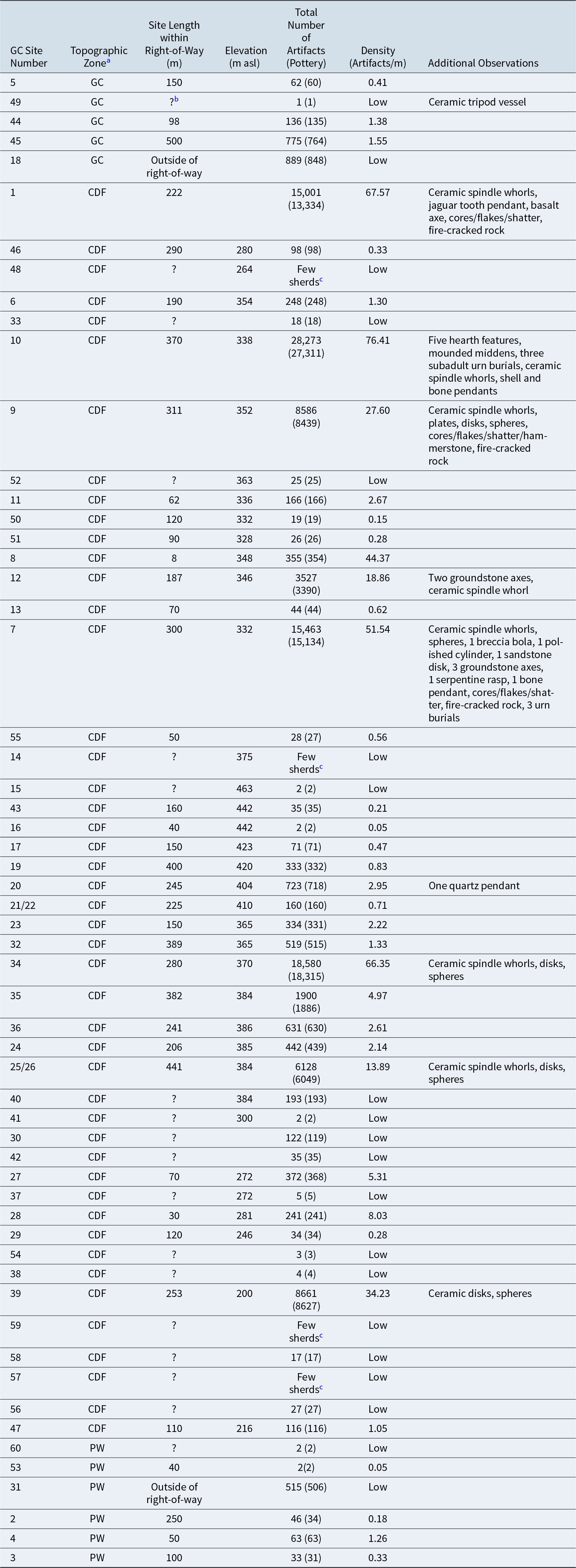
Most of the 58 sites were located in the semideciduous or subhumid dry forests of the Chiquitano Hills (Figures 2 and 4b). The Pantanal and Chaco portions of the survey produced small numbers of sites (0.03 sites/km, 0.06 sites/km, respectively) with low artifact densities compared to the Chiquitano Hills (0.52 sites/km) (Table 2). Site artifact density was measured by artifact frequency divided by site linear meters (Table 3, Figure 5b). While 15 sites in the Chiquitano Hills had artifact densities less than three per meter, none of the Chaco or Pantanal sites exceeded three artifacts per meter. If we include sites represented by small pottery scatters with no recorded linear measurements in the smallest artifact density class (<3 artifacts/m) then 26 sites in the Chiquitano Hills fall into this group.
Distribution of Sites by Topographic Zone in the Cuiabá Transect.

Note: Northern: Pantanal wetlands, headwaters of Paraguay River, seasonally inundated. Annual rainfall: 1,300 mm. Central: Chiquitano Dry Forest. Rolling hills to complex ridges. Annual rainfall: 1,200 mm. Southern: Northern Chaco plains. Xerophytic mixed forest, scrub vegetation. Annual rainfall: 1,100 mm.
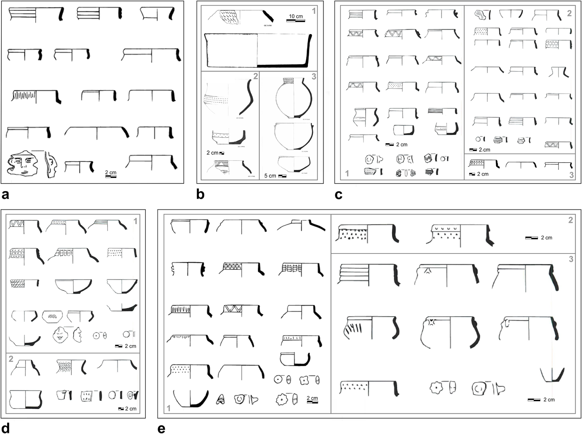
The Cuiabá survey results suggest that occupations were nonexistent prior to 900 BC for this portion of southeastern Bolivia (cf. Coltorti et al. Reference Coltorti, Fazia, Rios and Tito2010, Reference Coltorti, Fazia, Rios and Tito2012; May, Zech, and Veit Reference May, Zech and Veit2008). Site GC-39 produced the oldest date among the Cuiabá sites (Table 1). Charcoal from Unit 4, Level 5 associated with pottery dated to cal 970–540 BC (Figure 6a). Another charcoal sample from a basal deposit in Site GC-12 (Unit 13, Level 4) dated to cal 45 BC–AD 230. The remainder of the dates from the Cuiabá corridor suggest gradual in-filling of the landscape that peaked in the >cal AD 1200 range (Table 1). Early Yampara occupations identified in the Oroncota region of southeastern Bolivia dated to AD 400–800 (Alconini Reference Alconini2004). Alconini also documented increasingly dense occupations over the precontact period from AD 400 to 1536, a pattern consistent with the Chiquitano section of the Cuiabá corridor.
Cuiabá vessel profiles/surface decorations: (a) pottery concentration in Unit 4/Level 5, Site GC-39 dating to about 800 BC; (b) 1: Site GC-31 vessels, 2: Site GC-1 vessels comparable to pottery from Placitu Mayu in the eastern Andean foothills (Pärssinen Reference Pärssinen, Pärssinen and Korpisaari2003), 3: Sites GC-7 and GC-10 vessels; (c) Site GC-1 vessels. 1: pottery dated to about AD 1100, 2: pottery dated to about AD 1600, 3: pottery dated to about AD 1350; (d) Site GC-7 vessels. 1: pottery dated to about AD 950, 2: pottery dated to about AD 1300; (e) Sites GC-12 and GC-34 pottery. 1: Site GC-34 pottery dated to about AD 1450, 2: Site GC-12 vessels dated to about AD 1580, 3: Site GC-12 pottery dated to about AD 1300.

Summary Information for the Cuiabá Sites by Topographic Zone.

a GC: Gran Chaco; CDF: Chiquitano Dry Forest; PW: Pantanal Wetlands.
b Missing length information is associated with sites defined as isolated finds or small localized artifact scatters.
c Sherds noted in field, not collected.
By AD 700, groups began settling in with small to medium-sized settlements. Documented settlement sizes ranged from 8 to 500 linear meters, although from a 30 m wide transect it is difficult to accurately estimate site area. Some sites were intensively occupied. From about AD 1100 to contact, the Chiquitano portion of the survey revealed a rather dense cultural landscape, most likely increasingly linked in overlapping spheres of interaction that included greater Amazonia to the north and east and the Andes to the west.
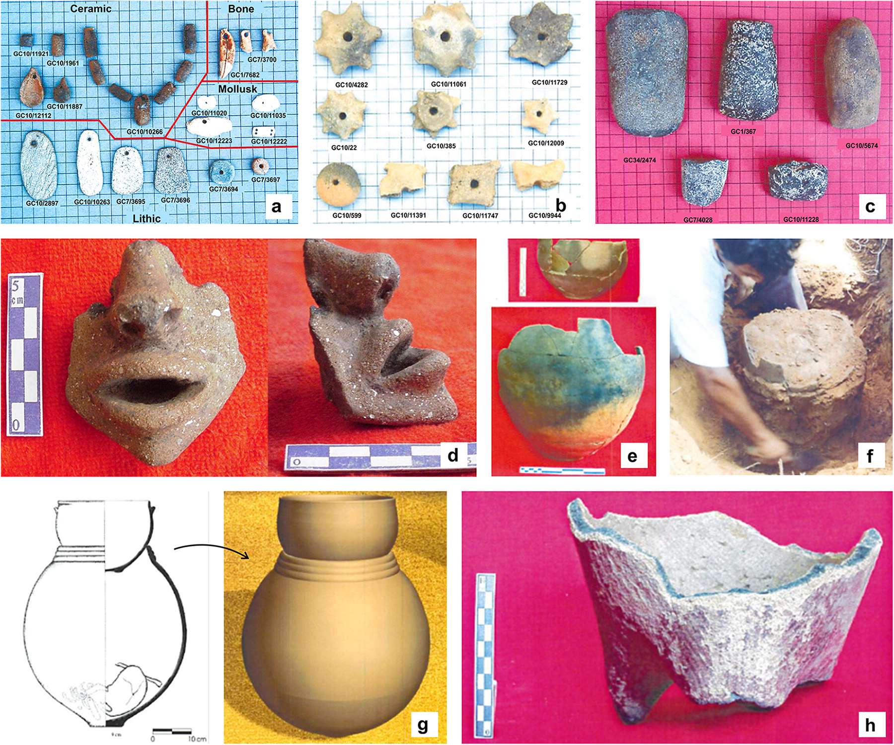
Occupational intensity was assessed by frequency and density of artifacts, range of artifact classes, and presence/kinds of features. Again, based on the 30 m wide survey corridor assessment of occupational intensity is limited by the kinds and portions of sites intersected. Results may overestimate small low-occupational intensity sites if edges of larger sites are documented. For sites with available linear dimensions, density is measured as artifacts per meter (Table 3). Five site artifact-density groups (ADGs) were defined. Out of 38 sites, 26 (68%) had less than three artifacts/m (ADG E). Seven sites (19%) ranged from 25 to 80 artifacts/m (ADGs A and B) and the remaining five sites (13%) were low (ADG D) to moderately dense (ADG C), with four to 20 artifacts/m (Table 3; Figure 5b). Sites with the highest artifact densities had greater ranges of artifact classes, including such features as hearths, burials, and midden deposits. All the sites in ADGs A and B were located in the Chiquitano Hills. Most of these sites included artifacts and features indicative of settled village life: spindle whorls, fire-cracked rock, chipped-stone tool production (cores, hammerstones, flakes, shatter), and midden deposits (Figure 7).
Distinctive artifacts from sites in the Cuiabá Chiquitano Dry Forest: (a) personal adornment items; (b) spindle whorls; (c) groundstone axes/adzes; (d) effigy vessel (Site GC-7); (e, f, g) recovery/reconstruction of corrugated burial urns (Site GC-10); (h) painted tripod vessel (Site GC-49). (Color online)

Settlements with dense artifact concentrations have been documented ethnographically in lowland South America to be associated with households (DeBoer and Lathrap Reference DeBoer, Lathrap and Kramer1979; Siegel and Roe Reference Siegel and Roe1986; Zeidler Reference Zeidler1984). Brochado (Reference Brochado and Joaquim Justiniano1984) documented Guaraní sites ranging from 100 m2 to 20,000 m2 to 50,000 m2. He suggested “a provisional site hierarchy” with “large central villages” surrounded by smaller sites (Brochado Reference Brochado and Joaquim Justiniano1984:259). Plotting the pipeline sites in 50-linear-meter increments and including sites with no length information in the less than 50 m group, the distribution is heavily weighted to small sites (Figure 5c; Table 3). Sites with no length information consisted of small pottery scatters, no more than a few square meters in area. Grouping sites into 100 m increments shows a bimodal distribution: large versus small sites (Figure 5d). We could be documenting evidence for a settlement hierarchy or alternatively a settlement pattern with different sites used for various purposes (Binford Reference Binford1982). Without full-coverage surveys we cannot discuss sociopolitical implications of these distributions; at this stage, they can be viewed only as suggestive patterns.
Distinctive artifacts found primarily at 14C-dated sites included vessels, balls, spindle whorls, and other ceramic objects; ground stone axes; and personal adornments of multiple materials (Figure 7). In common with lowland South American groups documented ethnographically, Guaraní-tradition vessels were made by wrapping clay coils around flat circular clay discs or forming vessels in a conoidal shape. Coils were smoothed probably using bivalve shells common in the assemblages. Some pottery was decorated, most commonly by incising, fingernail impressions, and punctation or nail incisions (Figure 6). The coils of the collar, neck, and shoulder regions of some vessels were left unsmoothed resulting in a corrugated appearance (Brochado Reference Brochado and Joaquim Justiniano1984:271–273). Painting was rare; a unique find was a tripod vessel from Site GC-49 (Figure 7h). Representational figures of humans and various creatures were modeled on or appliqued to the surfaces of some vessels (Figures 6a, 6d, 7d). Corrugated urns were reminiscent of those documented by Métraux (Reference Métraux and Steward1948c:Plate 41), Nordenskiöld (Reference Nordenskiöld1917:Figure 8), and Pärssinen (Reference Pärssinen, Pärssinen and Korpisaari2003; Figure 7g), seemingly linked to a broad horizonte corrugado extending to the far reaches of Amazonia by about AD 1000 (Guffroy Reference Guffroy2006).
Gas TransBoliviano Pipeline
Given the project construction schedule, the 557 km GBB corridor was divided into 12 sampling zones for systematic surveys, each considered to have a greater likelihood of archaeological sites. In addition, 100% of the pipe trenching was monitored for archaeological resources. In total, 85 km were surface-surveyed resulting in 13 sites and 18,610 artifacts. As in the Cuiabá survey, pottery made up the majority of the overall collection (94%). At 0.15 sites/km, the density of sites in the GBB corridor is approximately intermediate between the Pantanal and Chaco (0.03–0.06 sites/km) and the Chiquitanos Hills (0.52 sites/km) sections of the Cuiabá survey. Out of nine sites with linear measurements, five produced less than four artifacts/m and four had from 7 to 30 artifacts/m. Sites with low-to-moderate artifact densities were distributed across all three topographic zones within the corridor.
None of the 13 radiocarbon dates from the GBB corridor postdated AD 1280, and nine were in the AD 900–1200 range (Table 1). The absence of post-AD 1280 dates may be a sampling issue. Extracted bone collagen from Burial B in Site GBB-7 (Bañados del Izogog) dated to around cal 2700 BC. The burial was dated twice in separate labs with consistent results (Table 1). No artifacts were associated with the burial. Bone collagen from Burial A in the same site dated to AD 770–1010. Charcoal from excavated contexts in GBB-7 consistently placed much of the occupation in the AD 1000–1280 range. Burial B predates the major occupations of GBB-7 by 3,700 years. In the absence of artifacts associated with the burial it is difficult to say anything more than this is evidence for an early human presence in the Bañados del Izogog region of the Chaco. While not as old as the presumed antiquity of the remains reported by Coltorti and colleagues (Reference Coltorti, Fazia, Rios and Tito2010, Reference Coltorti, Fazia, Rios and Tito2012) or the artifact from the buried paleosol in the Andean piedmont Chaco (May, Zech, and Veit Reference May, Zech and Veit2008), Burial B provides additional evidence for a mid-Holocene presence of humans in the Bolivian Chaco prior to the Guaraní expansion into the region.
The 14C dates in Sites GBB-6 and 7, along the banks of the Bañados del Izozog, coincide with the estimated maximum age of the Bañados in this location (Table 1). Previously occupied by the Rio Parapeti, the Bañados were likely dry for a while, and prior to that occupied by an eastward flowing paleochannel of the Rio Grande, which eventually avulsed further north and abandoned the Bañados between 1.2 and 4.4 cal kya BP (May et al. Reference May, Cohen, Preusser, Veit, Wilkinson and Gunnell2023). The 4700 cal BP date for the GBB-7 burial coincides with available dates for an active eastward flowing Rio Grande channel providing runoff to the “proto-Bañados” (4.4–5.6 cal kya; May et al. Reference May, Cohen, Preusser, Veit, Wilkinson and Gunnell2023), suggesting a relationship between active rivers and human presence in this part of the Chaco.
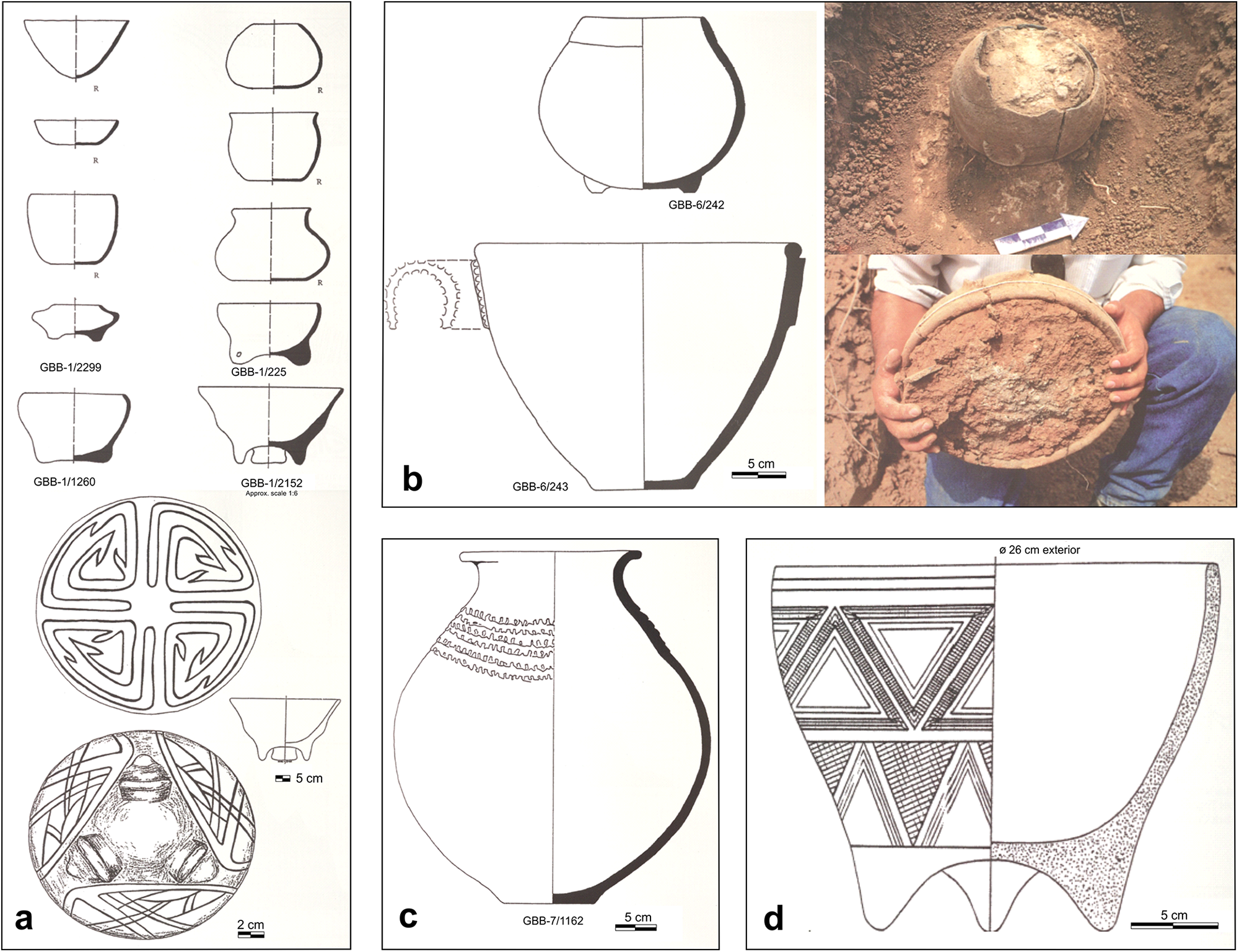
Although the density of sites in the GBB survey is low, three of them were relatively large with complex settlement layouts and two contained burials with elaborate grave offerings. Site GBB-1, approximately 4 ha in area and dating to cal AD 1000 (Table 1), produced several tripod ceramic vessels, a burial with a large polychrome vessel, several other polychrome and modeled vessels, and a copper bangle ornament (Figure 8a). As a whole, the assemblage suggests contact with or perhaps emulation of “Andean traditions” and “may be representative of goods belonging to the chiefly elite” (Gilstrap et al. Reference Gilstrap, Myers, Neff, Glascock, Neff and Vaughn2019:137) in addition to linkages with the Mamoré region of the Beni to the north (Alconini Reference Alconini, Clasby and Nesbitt2021:251; Myers and Esquerdo Reference Myers and Esquerdo1999:235–237).
GBB vessels: (a) Site GBB-1. top: vessel profiles, bottom: red-and-black painted tripod bowl; (b) Site GBB-6 closed tripod and deep-and-convex vessels dated to about AD 850; (c) large concave deeply incised urn from Burial A, Site GBB-7; (d) black-on-red painted tripod vessel, Site GBB-4. (Color online)

Site GBB-4 is located in Bañados del Izozog between the Parapeti and San Miguel Rivers and dates to AD 1100–1300 (Table 1). The site is approximately 9 ha in area, and nine spatially distinct artifact deposits may represent a series of disbursed households. One of the deposits produced a copper sheet and a black-on-red painted tripod vessel (Figure 8d). Organized labor projects are represented by a set of linear and circular mounds in relation to a reservoir or fish pond, suggesting water control most likely for agriculture or perhaps aquaculture (Alconini Reference Alconini, Clasby and Nesbitt2021:252; Gilstrap et al. Reference Gilstrap, Myers, Neff, Glascock, Neff and Vaughn2019:140).
Site GBB-7, about 20 ha in area, produced six burials and dates to AD 900–1280 (Table 1). Burial A, dating to around AD 900, produced a deeply incised decorated urn (Figure 8c). A second burial with no grave goods unexpectedly dated to 2700 BC, as discussed in the preceding text.
To assess the degree to which pottery was produced locally versus traded, instrument neutron activation analysis was conducted on 81 sherds from five sites across the three major environmental zones: Sites GBB-1 (Rio Grande); GBB-6, GBB-7, GBB-8 (Bañados del Izozog); and GBB-4 (Interriverine; Gilstrap et al. Reference Gilstrap, Myers, Neff, Glascock, Neff and Vaughn2019). Geochemically the sherds sorted into three distinct compositional groups linked to each of the three zones (Gilstrap et al. Reference Gilstrap, Myers, Neff, Glascock, Neff and Vaughn2019:Figures 13.2–13.4). Until raw clay samples are collected and compared geochemically with the pottery, we can tentatively suggest support for local production and use of pottery, most likely at the household level (Gilstrap et al. Reference Gilstrap, Myers, Neff, Glascock, Neff and Vaughn2019:144).
If Sites GBB-1 and GBB-4 represent locations of high-status individuals/families, we would expect evidence for intraregional settlement integration as well as some amount of interaction across regions (Earle Reference Earle1997; Hirth Reference Hirth1996; Johnson and Earle Reference Johnson and Earle1987; Roosevelt Reference Roosevelt, Bacus and Lucero1999). These suggestions will require full-coverage surveys beyond the limitations of the 30 m wide pipeline corridor and elemental analyses of other artifact classes in addition to pottery, especially the copper items.
Paleoenvironmental Reconstruction
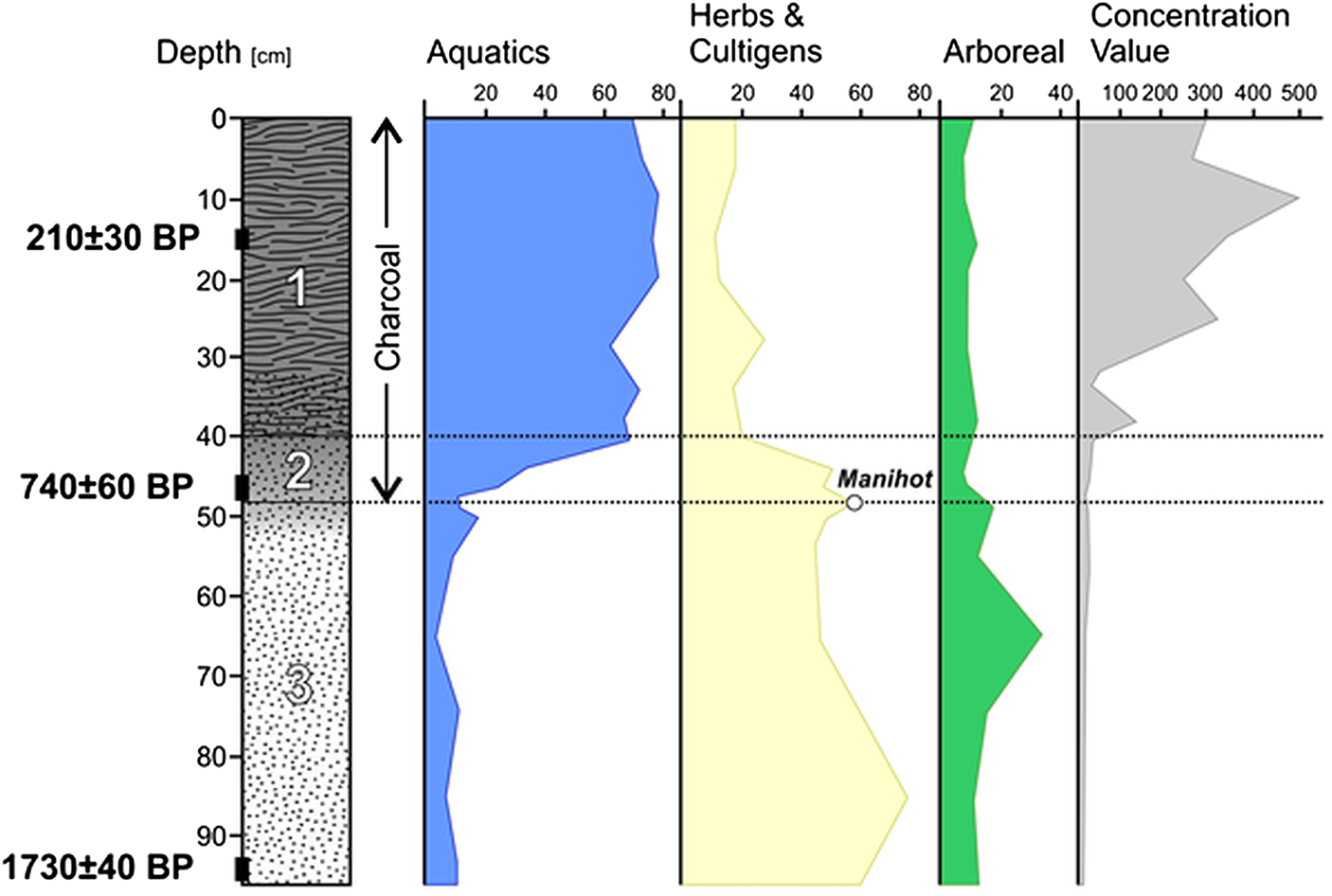
Two sediment cores were collected from the peat-forming Motacú wetland along the Rio Tucavaca in the Chiquitano section of the Cuiabá pipeline (Figure 2; Jones Reference Jones, Emlen, Wanderson, Angelina, Lígia, Peter and Paula2001). The lowermost portion of the cores (Zone 3) was characterized by sandy sediment of low organic content interpreted to reflect river flood deposits. While still sandy, the overlying Zone 2 was markedly darker in color with abundant charcoal. Zone 1, still rich in charcoal, was transitional from sandy to fabric peat in the uppermost ∼30 cm.
Sedimentological changes suggest a transition from a high-energy depositional environment (e.g., proximal levee) to a low-energy environment typical for a wetland on the distal floodplain, a trend reflected by increasing pollen concentrations toward the surface. While pollen preservation was excellent, many pollen types have never been documented and remain taxonomically unidentified. The pollen profile suggests that the area was characterized by a savanna landscape with a well-developed gallery forest fringing the streams from ∼220 BC until AD 1210 (Figure 9). By ∼AD 1210, aquatics appeared in the sequence, arboreal pollen abundant in the basal zone declined, and large-scale sustained burning was evidenced by elevated percentages of charcoal particulates. A single manioc pollen grain was associated with the onset of elevated charcoal particulates, around AD 1210. Changes in the pollen and charcoal records are consistent with the majority of radiocarbon dates from the Cuiabá pipeline and represent human disturbances to the landscape, most likely a product of slash-and-burn agriculture and forest modification (Iriarte et al. Reference Iriarte, Smith, de Souza, Mayle, Whitney, Cárdenas and Singarayer2017; Maezumi et al. Reference Maezumi, Whitney, Mayle, de Souza and Iriarte2018; Whitney et al. Reference Whitney, Dickau, Mayle, Soto and Iriarte2013).
Motacú wetland pollen diagram (after Jones Reference Jones, Emlen, Wanderson, Angelina, Lígia, Peter and Paula2001:Figure IX-1). Lower 48 cm reflects a savanna landscape with well-developed gallery forest. By AD 1200 aquatics appeared, arboreal pollen dropped out, and large-scale sustained burning evidenced by elevated percentages of charcoal particulates. A manioc grain was associated with the elevated charcoal particulates. (Color online)

Regional Implications of the Surveys
In total, 58 sites were identified along the 360 km Cuiabá corridor. Assuming uniform and even spatial distribution, we would expect 14, 15, and 29 sites in the southern, central, and northern zones, respectively (Table 2). Clearly, sites are not evenly or proportionally distributed across the landscapes intersected by the pipeline and that characteristics of the Chiquitano Dry Forest are attracting human occupations more readily than elsewhere (Figure 2). Within the dry forest, sites were concentrated to the higher elevations of the ridge zone. The ridge zone may have been attractive for its natural springs and the steeper topography may have been sought for defensive purposes later in precontact history, perhaps related to efforts by the Incas to expand the limits of their empire (Alconini Reference Alconini2004, Reference Alconini, Parker and Rodseth2005, Reference Alconini2008, Reference Alconini2016, Reference Alconini, Clasby and Nesbitt2021). These findings may be used as a set of expectations for future surveys in the Department of Santa Cruz and appropriate surrounding regions in Brazil, Paraguay, and Argentina.
Preconstruction pedestrian survey followed by pipe-trench monitoring of the 557 km GBB corridor identified 13 sites, comparable in site density to the Chaco and Pantanal sections of the Cuiabá corridor. Based on the two surveys, except for the Chiquitano Hills, much of southeastern Bolivia was lightly populated with small, dispersed communities. The frequency of sites in the Chiquitano Hills and their overall range of occupational intensity was higher than elsewhere in both surveys.
The earliest dated occupations in the Cuiabá survey were documented in Sites GC-39 (970–540 BC) and GC-12 (45 BC–AD 230), both located in the Chiquitano Hills. Both samples were associated with pottery deposits and may represent early pulses of human occupations to southeastern Bolivia, connected to what Alconini (Reference Alconini, Clasby and Nesbitt2021:247) considered a “second phase, approximately 1000–1 BC” of expansion into the region. Burial B from Site GBB-7 is the oldest evidence of human presence documented in either of the surveys (2880–2620 BC). No artifacts were associated with the burial so a cultural association cannot be offered.
Discussion
If the survey results are representative of the Bolivian southeastern lowlands, then most of these landscapes contain evidence of approximately 2,500 years of thinly distributed settlements, ranging from small dispersed to relatively settled and interconnected communities. There is possible evidence in Sites GBB-1 and GBB-4 for the presence of chiefly elites and perhaps interaction with Andean groups to the west and Mamoré Beni groups to the north. The ridges of the Chiquitano region were more densely occupied than elsewhere in southeastern Bolivia. This pattern may represent a refuge and more easily defendable area in light of the Inca border to the west.
This archaeological record reflects more than simply so-called nuisance groups that pestered the Inca Empire. To address community organization and regional integration among late precontact communities of southeastern Bolivia it is crucial to conduct full-coverage surveys and large-scale areal excavations of sites to collect household-scale data, similar in scope to Alconini’s work. The view taking shape is one of settled integrated communities following mixed economies of hunting, gathering, foraging, and agriculture. In expanding the southeastern boundary of their empire, the Incas may have established a frontier in this region precisely because of local well-integrated communities, especially in the Chiquitano Hills. As Alconini (Reference Alconini2004:413) observed, “The southeastern frontier, at the ecological interface of the Andes and Amazon, was not simply a line dividing internal and external territories. Rather, it took the form of an extensive zone of sociopolitical interaction.”
This dry-forest east-of-the-Andes landscape contains a record of ever-changing social formations that is the heritage of the current residents and may form a part of the larger lowland cultural pattern envisioned by others (Brochado Reference Brochado and Joaquim Justiniano1984; Clasby and Nesbitt Reference Clasby and Nesbitt2021; Lathrap Reference Lathrap1970). The pipeline investigations represent the first systematic archaeological surveys conducted across a crucially important yet poorly understood region of lowland South America. Results of the surveys provide a set of expectations to guide future investigations in this intermediate zone between the Andes and the Amazon.
Acknowledgments
The surveys were conducted by Dames & Moore SA on behalf of GasTransBoliviano SA and Gas OrienteBoliviano SA. We gratefully acknowledge the support and assistance of Gonzalo Saavedra, Omar Clauré, Carlos Méndez, and Jeffery Bentley. Addressing the comments of three reviewers greatly improved the paper.
Funding Statement
Funding was provided by GasTransBoliviano SA and Gas OrienteBoliviano SA.
Data Availability Statement
Data from the surveys are available in two compliance reports (Myers and Esquerdo Reference Myers and Esquerdo1999; Myers et al. Reference Myers, Esquerdo, Muñoz, Camacho, Siegel and Bienenfeld2001).
Competing Interests
The authors declare none.
Supplementary Material
For supplemental material accompanying this article, visit https://doi.org/10.1017/laq.2025.10163.
Supplementary Material 1. Chaco region of the Andean piedmont: (a) quartzite scraper from buried paleosol dating to ca. 8800 BP; (b) pottery from aeolian deposit dating to ca. 2800 BP (figure).