Archaeologists have long recognized the Puuc region of the northern Yucatan Peninsula for the high quality of the stonemasonry employed in the construction of its distinctive architecture. The intricate mosaic moldings and masks adorning high-status buildings are just a few of the embellishments that have become emblematic of the Puuc architectural style. The high frequency of masonry architecture in the region, sometimes as much as a third of all buildings, suggests the critical importance of the limestone industry to the local political economy (Ringle et al. Reference Ringle, Negrón, Bey, Masson, Freidel and Demarest2020). Yet, despite the attention paid to the building tradition over the past century, decidedly less research has focused on the quarrying and processing of the materials used to construct these edifices. This paper presents the findings of an investigation into limestone quarrying and processing practices at the Puuc site of Muluchtzekel, including lidar-based spatial analyses of quarry and lime pit-kiln locations, and excavation data from a large ledge quarry (lidar is an acronym for “light detection and ranging”). It also highlights the advantages and limitations of using lidar-derived digital terrain models (DTMs) for identifying and examining various forms and sizes of quarries. The data suggest that access to high-quality limestone was one of several factors influencing the location of large architectural groups but was likely not the primary factor. The paper concludes by evaluating the degree to which quarry and lime kiln distributions at Muluchtzekel support two competing models for local stone-industry organization.
Muluchtzekel is a large site with construction episodes dating from the Preclassic through the Terminal Classic period (approximately 500 b.c. to a.d. 900) (Figure 1). It extends over more than 6.5 km2 and is strategically located on the border between the hilly Bolonchen district to the south and the broad, flat expanse of the Valle de Santa Elena to the north. The authors conducted a systematic lidar-based pedestrian survey and test-pitting program at the site between 2018 and 2020 (Ringle et al. Reference Ringle, Negrón, Seligson and Vlcek2018, Reference Ringle, Negrón, Ciau, Seligson, Fernandez-Diaz and Zapata2021; Ringle and Seligson Reference Ringle, Seligson, Negrón, Ringle and Bey2021), the results of which form the basis of this article.
Map showing location of Muluchtzekel in the eastern Puuc region and highlighting the area of the 2017 lidar flyover that included Muluchtzekel. Image adapted from base map by NASA/JPL.

Limestone Quarrying in the Puuc Region
The majority of the Yucatan Peninsula is a limestone shelf that emerged from an ancient shallow sea relatively recently in geological terms. The bedrock of the Puuc region, however, represents an older Miocene formation (Ward Reference Ward, Ward, Weidie and Back1985) with higher frequencies of compacted or finer-grained limestone considered more desirable for architectural purposes (Carmean et al. Reference Carmean, McAnany and Sabloff2011:147). Not all limestone in the Puuc is equally suitable for construction or burnt lime production, however, especially to the discerning eyes of specialist stonemasons and engineers. The quality of limestone varies significantly not only between different outcrops, but also within outcrops, the result of both formation and weathering processes (Brennan et al. Reference Brennan, King, Shaw, Walling and Valdez2013:3179; Carmean et al. Reference Carmean, McAnany and Sabloff2011:147; Glumac et al. Reference Glumac, Lope, Masson and Russell2019; Seligson et al. Reference Seligson, Negrón, May and Bey2017b, Reference Seligson, Ruiz and Pingarrón2019).
Although today most construction materials come from nonlocal sources, local workers can still identify at least four discrete types of limestone based on texture and appearance. These include sakel bach tunich (white chacalaca stone) and tok’ tunich (flint/hard stone)—the two most desirable grades for construction—as well as chac tunich (red stone), which has a distinct reddish or pinkish hue, and sah kab tunich or sascab (white earth stone), limestone marl which is too soft and friable to be used as building blocks but can be processed to make tamped floors or as architectural fill (Ahern Reference Ahern2021; Barrera Vázquez Reference Barrera Vázquez1980; Folan Reference Folan1978, Reference Folan1982; Littmann Reference Littmann1967; Seligson et al. Reference Seligson, Negrón, May and Bey2017b). Sakel bach tunich is considered the most desirable type for making burnt lime, though chac tunich is occasionally used as well. All four limestone types are found throughout much of the Maya lowlands in both hard surface caprock layers and deeper foundational bedrock layers.
Multi-elemental analyses of 95 bedrock limestone samples recovered from quarries across the Puuc sites of Muluchtzekel and Kiuic reveal a few trace elemental distinctions between the four modern categories, but mainly reinforce the importance of texture and appearance for distinguishing grades. Table 1 provides the multi-elemental data for the different stone samples in parts per million. Local Mayan-speaking collaborators identified each of the samples as belonging to one of the four categories. Elemental compositions were then tested using inductively coupled plasma optical emission spectrometry (ICP-OES) in the case of the Kiuic samples and portable X-ray fluorescence (pXRF) for the Muluchtzekel samples.
Inductively coupled plasma optical emission spectrometry and portable X-ray fluorescence limestone data

Results indicated that the reddish-pinkish hue of chac tunich unsurprisingly derives from its relatively higher levels of iron, which ranges between 1.73 and 24.4 parts per million (ppm), and averages approximately 8.83 ppm, compared with an average of between 0.28 and 1.32 ppm for the others. The pinkish hue usually makes this grade less desirable for architectural facings and lime production, though there are notable exceptions such as at the Puuc site of Chacmultun, where the entire site center is composed of pink-hued stones. Sakel bach tunich tends to have slightly higher sulfur levels than the other four types (average 0.87 ppm, compared with a range of 0.58 to 0.73 ppm for the others). Sascab possesses higher levels of magnesium (average 6.5 ppm) than the other three types of limestone (average range of 2.79 to 4.39 ppm) due to percolation of magnesium atoms downward through the caprock with rainwater (Seligson et al. Reference Seligson, Negrón, May and Bey2017b; Villaseñor Reference Villaseñor2010:25). All four types possess relatively low levels of potassium, averaging less than 1 ppm, though sakel bach tunich and sascab exhibited relatively wider ranges (0.008 to 0.77 ppm and 0.014 to 1.75 ppm, respectively) than the consistently low levels found in chac and tok’ tunich. Tok’ tunich is a general term for the hardest grades of limestone in the eastern Puuc and of all samples tested, it consistently has the lowest levels of non-calcium-carbonate components. Builders likely preferred it for architectural purposes due to its durability and due to the difficulty of transforming it into burnt lime or breaking it up into fill or lithic mulch.
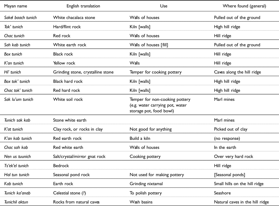
Aside from the few minor distinctions discussed above, the multi-elemental analyses highlight the general overlap in elemental composition between the four modern categories and the resulting difficulty of chemically sourcing building blocks. They also underscore the deep levels of skill and experience necessary for local stoneworkers to be able to distinguish between the types of limestone based on color, texture, and fracturing patterns. Unpublished ethnographic research by Dean Arnold confirms that recent generations of potters in the northern Yucatan were familiar with up to 20 discrete categories of limestone. Alfredo Tzum, a potter from the town of Ticul, related the local Yucatec Mayan terms for the various grades of limestone (Dean Arnold personal communication 2015; Seligson Reference Seligson2016; Seligson et al. Reference Seligson, Negrón, May and Bey2017b) (Table 2). The categories described by Tzum had specific significance for pottery production, including for use as paste temper and in ceramic kiln construction. It is likely that stonemasons had their own nuanced understandings of limestone gradations as well. Although it is unwise to project modern knowledge of limestone variation directly back to the precolonial period, it is possible that quarry locations represent areas where stone experts identified substantial concentrations of the most prized construction-worthy grades.
Local ethnopetrology and ethnogeology according to Ticul potter Alfredo Tzum as recorded by Dean Arnold 1965 (personal communication 2015, adapted from Seligson Reference Seligson2016, with added translations from Barrera Vázquez Reference Barrera Vázquez1980)

As was the case elsewhere in the Maya lowlands, excavators extracted limestone by means of at least four types of quarries: pit quarries, ledge quarries, subterranean sascaberas, and outcrop or expedient quarries. These quarry category distinctions have been applied by other archaeologists (Horowitz et al. Reference Horowitz, Clarke and Seligson2021) and are adopted here by the authors. Local Yucatec collaborators on the project did not distinguish different types of features and instead used the Spanish word cantera to apply to all forms of quarries. Pit quarries are depressions formed by excavating into relatively flat tracts of bedrock (Figure 2). Ledge quarries are typically located on sloping terrain where limestone could be pried from existing outcrops (Figure 3). They can be recognized by the relatively linear bearing of the outcrop edge, although some ledge quarries are lunate in form. Occasionally several parallel ledges formed ascending steps on hill slopes, as is the case with the Kaxnak quarry discussed below. The third type, subterranean sascaberas, are locales where the ancient quarriers excavated tunnels under the harder caprock to remove the softer sascab below (Figure 4). Expedient quarries refer to the small-scale temporary or non-systematic use of small outcrops probably chosen because of their proximity to building sites. Households would thus have been able to access stone for a variety of purposes (e.g., foundation braces, expedient tools, weapons, doorjambs, sitting stools, hearth stones, boiling rocks, etc.) without excavating large pits or preparing ledges for quarrying. Although such uses were important to daily life, it is unlikely they would have contributed significantly to the local sociopolitical economy.
Examples of two pit quarries at Muluchtzekel. Photographs by Kenneth E. Seligson.

A ledge quarry at the Puuc site of Kom (after Ringle et al. Reference Ringle, Negrón, Ciau, Seligson, Fernandez-Diaz and Zapata2021). Photograph by William M. Ringle.

A large sascabera chamber at Kiuic. Photograph by Kenneth E. Seligson.

We propose the inclusion of a fifth type of quarry—a sheet quarry—that, like the small outcrop/expedient quarry category, remains difficult (though not impossible) to identify in the lidar DTM imagery. Sheet quarries are characterized by the extensive but shallow removal of layers of surface limestone, perhaps averaging only a meter deep. They resemble ledge quarries along their edges and involve modification of extensive areas of relatively flat but raised terrain (not agricultural planadas). A similar quarry type has also been preliminarily identified in the Río Bec area just to the south of the Puuc (Gillot Reference Gillot2018). Figure 5 provides an example of a possible sheet quarry immediately to the west of the Muluchtzekel acropolis. The existence of sheet quarries is also supported by the stark discrepancies between the total volume of visible pit quarries and the volume of construction projects, discussed below. Until such extensive areas can be thoroughly tested, sheet quarries remain hypothetical and this paper focuses specifically on the pit and ledge quarries identified via remote sensing and ground reconnaissance.
A possible sheet quarry to the west of the Muluchtzekel acropolis. Image by authors.

Quarry Distribution at Muluchtzekel
We were able to develop a preliminary inventory of quarry features using lidar imagery gathered in 2017 over a large tract of the eastern Puuc region, including all of Muluchtzekel. The airborne survey covered a total of 237 km2, and the resulting DTM was processed to a resolution of 0.5 m by Juan C. Fernandez-Diaz of the National Center for Airborne Mapping (Ringle et al. Reference Ringle, Negrón, Ciau, Seligson, Fernandez-Diaz and Zapata2021). During the 2018 and 2019 summer field seasons, the authors directed a pedestrian survey to ground-truth archaeological features within an approximately 2 km2 sample of the central 6 km2 zone of Muluchtzekel. Using the DTMs as guides, we verified dozens of quarries, pit-kilns, and architectural signatures, confirming the ability of lidar to consistently detect features of this magnitude (Ringle et al. Reference Ringle, Negrón, Seligson and Vlcek2018, Reference Ringle, Negrón, Ciau, Seligson, Fernandez-Diaz and Zapata2021; Ringle and Seligson Reference Ringle, Seligson, Negrón, Ringle and Bey2021). Pit quarries are the most easily identified in the lidar DTM, with ledge quarries only slightly less so. All large quarries first identified using the DTM were verified through subsequent pedestrian survey.
On the other hand, our study also highlighted the limitations of relying too heavily on lidar data. During ground reconnaissance, we identified several expedient quarries that were not readily visible in the lidar imagery. For instance, a small outcrop quarry located approximately 18 m south of a hilltop residential complex at Muluchtzekel does not possess a clear signature in the lidar data despite having uniform cuts and extracted in situ stones visible during the ground survey (Figures 6, 7). The edge of the possible large sheet quarry shown in Figure 5 was preliminarily identified during ground survey, after which we were able to identify its boundaries using the lidar DTM. These examples highlight the difficulty of identifying quarry signatures solely by means of standard lidar hillshade filters and reinforce the importance of combining remote sensing and ground reconnaissance. Alternative filters, such as slope surfaces, or higher-resolution DTMs may prove useful for identifying such smaller outcrop quarries or sheet-quarry boundaries in the future.
Lidar image demonstrating the difficulty of distinguishing the small outcrop quarry from the surrounding landscape features. Image by authors.

Photograph of the small outcrop quarry. Photograph by Kenneth E. Seligson.

Subterranean sascaberas, or sascab mines, are another type of quarry that are difficult to identify using lidar alone. Apart from their entrances, they are almost invisible in the lidar imagery, except in cases where the tunnels or mines have collapsed and are visible as a surface depression. The similarity in DTM signatures between collapsed sascaberas and collapsed chultuns, or underground cisterns, highlights the overlap in function between these two feature classes. The sascab removed during the chultun excavation process would undoubtedly have been put to architectural purposes, including building fill, mortar, or tamped floors. It is possible that during the excavation of their cisterns, household groups lacking identifiable sascaberas harvested sufficient sascab for household needs. Chultuns should thus be considered as a type of sascab mine and thus included in any study of sascabera distribution and exploitation. The majority of chultuns are readily distinguishable in the eastern Puuc lidar imagery, whether intact or collapsed, as they are almost always excavated into house platforms.
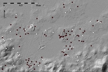
This study focuses specifically on non-sascab forms of limestone extraction, however. Excluding sascaberas, 160 quarries were identified using the DTM covering the 6 km2 site core of Muluchtzekel (42 ledge quarries and 118 pit quarries), scattered across the site at an average interval of 37.5 m (Figure 8). Pit quarries could usually be identified using ArcGIS's cut-fill tools, although this was less successful for quarries excavated on a hill slope. Nearest-neighbor analyses indicate that the distribution of quarries across the site is not random (z-score = −13.954, p-value = 0.000). They have a high correlation with architectural groups, averaging approximately 34.4 m from the nearest architectural feature. Seventy-five percent of quarries identified in the lidar DTM are located within 40 m of the nearest architectural feature, although the range is wide (6.9 to 89.5 m). Unsurprisingly, the highest concentrations of pit quarries are correlated with the areas of densest architectural features. This includes the three clusters of public architecture at the center of Muluchtzekel and a neighborhood with two very large, vaulted structures in the southwestern sector of the site. In these areas, quarries averaging no more than 8 m in diameter exist like pockmarks surrounding the structures (Figure 9). Only a handful of quarries are larger than 13 m in diameter, and they are closest to the largest architectural compounds near the site center. Quarries are located exclusively on raised terrain or on the slopes of hills. Communities probably reserved the flat planadas for agricultural purposes in a similar manner to today, as quarrying in these areas requires removal of a considerable overburden of clay soil.
Locations of pit quarries (black diamond) and ledge quarries (white circle) at Muluchtzekel identified using the lidar-based DTM. Image by authors.

The location of pit quarries (solid shading) within one of Muluchtzekel's three core architectural zones. Image by William M. Ringle.

To assess whether building stone was typically quarried near building sites, we examined the area around a concentration of civic structures measuring about 350 by 360 m (1.26 ha), an area which also included 10 house platforms and several pits and depressions. The civic structures included a large platform supporting a long range structure in the northwest quadrant, a patio group in the southwest (Grupo Xux), an elaborate version of an Early Puuc Civic Complex (Ringle et al. Reference Ringle, Negrón, Ciau, Seligson, Fernandez-Diaz and Zapata2021) to the east of the Grupo Xux, and then several platforms and buildings connecting them. These structures are outlined in Figure 9 with long dashes; house platforms are outlined in shorter dashes.
The volumes of pits with relatively level upper lips can be calculated using the ArcGIS “fill” command, which fills all sinks in a DTM to the level of their pour point (the height at which water would begin to overflow the rim) and then subtracts the volume of the original DTM. The volumes of platforms sitting on level ground can be similarly measured by inverting the DTM. But since quarries and platforms are often situated on uneven or sloping terrain, we adopted an alternative method using ArcGIS's “surface volume” command, which estimates the volume of a surface above or below an arbitrarily specified level plane (in our sample a plane elevation of 40 m ran below all surface points on the original DTM). We then generated several DTMs from edited point clouds. In one, we excluded all points within putative quarries, in another all points within the footprints of civic platforms, and in another we removed points within house platforms. In the course of generating DTMs from these new point clouds, ArcGIS extrapolated a surface across these new gaps in the point clouds using the lidar points along the edges of platforms or quarries, approximating the original land surface without pits or platforms. The volumes of these surfaces above or below the 40 m plane could then be compared with the original surface to determine the volume of quarry areas and platforms.
The extrapolated “original surfaces” were clearly approximations, and the method does not take into account the fact that platforms often took advantage of natural hillocks to lessen the quantity of needed fill. Nevertheless, the contrast between excavation and construction volumes is undeniable. The three large complexes of civic architecture alone required about 30,000 m3 of fill (the acropolis in the upper right quadrant alone constituted about 13,100 m3). By comparison, the pit quarries totaled only around 670 m3, insufficient even for the needs of house platform construction, estimated at 4,200 m3. Builders could lessen the quantity of platform fill by building over natural promontories (although this is a low-lying area of the site), demolishing those to create fill, and/or superimposing new structures atop earlier, partially dismantled ones. Whatever the case, workers had to bring substantial quantities in from some distance. The amount necessary may have been as much as about one-fourth of the sample area quarried to a depth of 1 m, yet we have found no such large-scale quarrying scars in the lidar imagery, except for the possible large sheet quarry to the west of the Middle Formative acropolis. The existence of shallow sheet quarries near the areas with the largest construction projects would help explain the discrepancy between the estimated construction fill and the volume of fill potentially provided by pit quarries.
Lime Production and Pit-Kiln Distribution at Muluchtzekel
The amount of burnt lime (calcium hydroxide) necessary to complete the extensive vaulted architectural program, as well as to nixtamalize enough maize to feed an expanding population, meant lime production was a key part of the local limestone extraction and processing industry, especially during the population and construction booms of the Late and Terminal Classic periods (ca. a.d. 650−950) (Ringle et al. Reference Ringle, Negrón, Bey, Masson, Freidel and Demarest2020; Seligson Reference Seligson2016; Seligson et al. Reference Seligson, Negrón, May and Bey2017c, Reference Seligson, Ruiz and Pingarrón2019). Lime production during this period was enhanced by the adoption of an annular pit-kiln technology. Pit-kilns were created by excavating a circular depression directly into the bedrock and surrounding it with a low stone wall that would be built up over time until it eventually resembled a mounded ring. Burning in the central chamber would loosen the underlying bedrock, allowing some pits to reach depths of over 3 m. Similar lime pit-kilns have been identified in other regions of the northern and central lowlands, most notably by Soledad Ortiz Ruiz and colleagues in the Ichkantijoo Region of the northwestern Yucatan (Goguitchaichvili et al. Reference Goguitchaichvili, Ortiz-Ruiz, Morales, Kravchinsky, de Lucio, Cejudo, Garcia, González, Ruvalcaba and Pingarrón2020; Ortiz Reference Ortiz2019). Experimental archaeological research by the first author has demonstrated that the pit-kilns were likely more fuel-efficient than aboveground pyre methods (Seligson et al. Reference Seligson, Negrón, May and Bey2017a, Reference Seligson, Negrón, May and Bey2017b).
Previous studies of intra-site lime kiln distribution at Kiuic (Seligson Reference Seligson2016; Seligson et al. Reference Seligson, Negrón, May and Bey2017c) and at the broader regional level for the eastern Puuc (Ringle et al. Reference Ringle, Negrón, Ciau, Seligson, Fernandez-Diaz and Zapata2021) suggest a decentralized production industry with kilns about evenly divided between the hinterlands and settlement cores. We have thus far identified 54 annular pit-kilns within the 6 km2 central core of Muluchtzekel, only one of which is not identifiable as such in the lidar DTM. Fifty-four is a relatively low frequency considering the large size and high architectural density of the site (Figure 10). For example, we recorded 52 annular structures within a 2.8 km2 study area of the smaller conurbation of Kiuic. This suggests that lime producers at Muluchtzekel likely continued to use aboveground pyre production at a higher rate than at Kiuic, that producers completed more annual firings in each of Muluchtzekel's pit-kilns than at Kiuic, or that lime was imported from kilns located beyond the site limits.
Distribution of annular lime-pit-kilns across the Muluchtzekel site core. Image by Kenneth E. Seligson.

The discrepancy is undoubtedly related to differences in topography and environment, as Kiuic is situated squarely within the Bolonchen hill district, while Muluchtzekel straddles the border with the Valle de Santa Elena and encompasses a far higher percentage of planada terrain. Twenty-six of the annular structures exist within the approximately 2.43 km2 hilly southern zone of the site core, while 28 exist within the 3.57 km2 flatter northern zone. Although differences of density are not overwhelmingly significant, this translates to an average of 10.7 annular structures per km2 in the hilly zone compared with 7.84 per km2 in the intermediate zone, and none in the planada. In contrast, the neighboring site of Tabi-Xunantunich, located wholly within the Valle de Santa Elena and without hills in its immediate vicinity, possesses 32 annular structures within the 2.0 km2 covered by the site (density = 16/km2). Farther south in the Bolonchen hills, overall density is high—Kiuic has approximately 18.6 annular structures per km2 (n = 52, area = 2.8 km2)—but then thins rapidly further south.
As for the sizes of annular structures, those from Muluchtzekel range from 6.1 to 13.5 m in diameter, overlapping the size range of Kiuic. Kiln size does not appear to pattern geographically across the site, nor is there a correlation between kiln size and proximity to architectural features, although Tomás Gallareta Negrón (personal communication 2020) has encountered a few large centrally located pit-kilns in some of the smaller Bolonchen sites.
Although a nearest-neighbor analysis of the annular structures suggests that they were spaced randomly with regard to each other (z-score = −0.524, p-value = 0.600), their locations are strongly correlated with elevated and/or sloping terrain, which mirrors the pattern previously identified at Kiuic. All 54 are situated directly atop bedrock and 30 (56 percent) were built into or immediately adjacent to the base of a hill. Interestingly, however, at least 11 are located along the edges of the planadas, for reasons that are not clear. The average distance between annular structures at Muluchtzekel is 148 m, indicating a dispersed distribution across all architectural zones of the site. The average distance between annular structures and residential architectural features is 31.3 m (range = 3 to 76 m), but 50 percent of annular structures are located within 25 m of a residential platform and two-thirds are located within 40 m, indicating many platforms had easy access to pit-kilns. Individual household groups never appear to have more than one associated annular structure, contrasting with the micro-clusters identified at Kiuic and other Bolonchen sites like Acambalam.
Only 14 (26 percent) of annular pit-kilns at Muluchtzekel are located within 75 m of a visible quarry. The lack of correlation between annular structures and quarries strongly suggests that the limestone used for burnt lime production was not excavated from the large quarries most visible in the lidar DTM. Instead, lime producers most likely built annular pit-kilns in areas where suitable grades of limestone, like sakel bach tunich, were readily available from smaller surface outcrops. The stone excavated from the larger ledge and pit quarries was thus likely used for architectural and other household purposes.
Stone Extraction at the Kaxnak Quarry
Kaxnak (“belt” in Yucatec Mayan) quarry, an unusually long ledge quarry located in the southwestern sector of Muluchtzekel, was test-excavated during the 2019 field season. The quarry lies at the northern base of a large hill; further north, the terrain levels off and is occupied today by several milpas and orchards. The quarry itself is currently covered by forest and dense undergrowth and was originally identified using the lidar DTM. The quarry measures approximately 47.5 m long and consists of four tiers. Each tier, or shelf, is roughly 1 m high and ranges from 2 to 4.5 m wide, but not all are continuous for the full length of the quarry. A cluster of basal platforms supporting seven structures and two chultuns extends from the southeastern terminus of the quarry. None of the structures are vaulted. A lower-lying patch of terrain adjacent to the ledge may represent an area from which stone was already excavated (Figure 11).
The Kaxnak ledge quarry as seen in the lidar-based digital terrain model and a photograph of the Kaxnak quarry excavation. Image by authors.

The bulk of the stone currently exposed in the four ledges of the quarry consists of tok’ tunich with some chac tunich and a few small pockets of sakel bach tunich. The ubiquity of chac and tok’ tunich throughout the Kaxnak quarry suggests that these were the two main grades that were extracted from this location, though it is also possible that other types of limestone were dominant in the sections that had already been quarried away. The underlying sascab layer was reached in a few small areas, possibly leading to the cessation of quarrying in those locales. It is likely that the stone extracted from this quarry was used to construct the platform complex located at its southeastern terminus.
Three 2 × 2 m test pits and one 12 × 2 m trench exposed portions of the quarry, permitting visual analysis of quarrying processes. The trench provided a cross-section of the four tiers, exposing the edges of the bedrock shelves where stone blocks had been methodically removed. Unlike quarries excavated at Santa Amelia, Nakbe, and Xultun (Beekman Reference Beekman1992:100; Clarke Reference Clarke2020; Hansen et al. Reference Hansen, Forsyth, Woods, Schreiner, Titmus, Kathryn Brown and Bey2018; Titmus and Woods Reference Titmus, Woods and Hansen1992, Reference Titmus, Woods, Laporte, Escobedo and Arroyo2002), however, the stones excavated from this quarry were not removed as clean square or rectangular blocks. The uneven blending of different grades of stone in the local matrix resulted in the removal of irregularly shaped boulders, leaving behind equally irregular quarrying scars that were only approximately linear. This suggests that stones removed from this quarry were either destined for the fill of nearby architectural features or were shaped following extraction from the ledge. The size of the ledge quarry suggests sustained or repeated extraction for use beyond the immediately adjacent platforms, for instance in the construction of two small platforms located on relatively flat terrain just 85 m to the north-northeast.
Twenty-two small flakes (16 chert, four limestone, two quartz) ranging in size from 12.2 mm up to 72.9 mm long (Figure 12) were recovered from this small excavation sample. Chert is a fine-grained silicate-based sedimentary rock that forms within limestone bedrock. Small nodules of chert exist in the Puuc, though they are more common toward the southern edge of the region (Potter Reference Potter, Sabloff and Henderson1993:288–290), and it is unlikely that there were significant quantities available in the local bedrock of Muluchtzekel. Chert and quartz are harder grades of stone than calcium carbonate, and the four limestone flakes are of the tok’ tunich variety, suggesting that these flakes were either used as expedient tools in the extraction process or chipped off larger hafted stone tools during the extraction process. The morphology of the largest chert flake, as well as evidence of wear, makes it the most likely candidate to have chipped off of a bifacial tool similar to those identified by Titmus and Woods at the Nakbe quarry (Reference Titmus, Woods, Laporte, Escobedo and Arroyo2002). Preliminary analysis has also identified minimal wear on a few of the smaller flakes. The lack of identifiable wear on the larger, narrower flakes that could have potentially been used as tools is perplexing and suggests they were discarded during expedient tool production at the quarry.
The 16 largest lithic flakes recovered during the excavation of Kaxnak quarry. Photographs by Kenneth E. Seligson.

The scarcity of quarrying tools is a pattern mirrored in excavations of quarries elsewhere in the Maya lowlands, where archaeologists have suggested that the absence of tools probably reflects their safekeeping in the homes of those doing or controlling the quarrying activities (Beekman Reference Beekman1992:100; Hansen et al. Reference Hansen, Forsyth, Woods, Schreiner, Titmus, Kathryn Brown and Bey2018:165). Excavations by Evan Parker within a mason's residential compound at the eastern Puuc hilltop complex of Escalera al Cielo uncovered a suite of masonic tools (Parker et al. Reference Parker, Bey and Negrón2019:29). Among the tools were two chert chisels that workers likely used to extract material from the surrounding sascaberas in addition to being used for shaping harder stone blocks. (See Horowitz et al. in this Special Section for further discussion of quarrying tools.)
A close examination of the edges of the four tiers revealed a repeated pattern of four or five small indentations, roughly 4 to 5 cm wide (Figure 13). It appears that workers drilled four or five small holes in the bedrock into which they could then stick a wedge and pry the stone from the matrix. This pattern of four or five indentations was identified in seven separate locations within the 12 × 2 m trench, indicating that it was a purposeful process. Four of these seven locales were clearly visible in the field during excavations. The other three were identified after processing the photographic data into a 3D photogrammetric model of the trench excavation using Agisoft Photoscan software. One option of Photoscan is to create a monochromatic high-density surface mesh that allows for the visual identification of surface features that the natural color patterning of the limestone may obscure. Using the previously identified removal areas as a baseline, this monochromatic surface allowed the identification of an additional three locations that were clearly visible in the photogrammetric model but were not observed in the field.
Photoscan model showing the application of a monochromatic high-density surface mesh to identify five small indentations representing locations where wedges were inserted to prize boulders from the ledge quarry. Image by Kenneth E. Seligson.

Similar evidence of drill holes or cuts in quarry walls were identified at Coba (Folan Reference Folan1978:81), Nakbe (Titmus and Woods Reference Titmus, Woods, Laporte, Escobedo and Arroyo2002), and Xultun (Clarke Reference Clarke2020). Titmus and Woods (Reference Titmus, Woods, Laporte, Escobedo and Arroyo2002:198) hypothesized that the small holes identified in the surface of the Nakbe quarry, which ranged from 5 to 15 cm long, were created using a narrow biface attached to a wooden handle. It is likely that similar (though even narrower) tools were used to drill the holes in the surface of the Kaxnak quarry. The identification of two large stones with similar semicircular indentations that appear to have been pried from the bedrock matrix but not removed from the quarry suggests that stones removed averaged 50 × 40 × 35 cm in size. The tremendous weight of boulders this large, roughly 190 kg (using 2,711 kg/m3 as an average limestone density), provides further evidence that they were either used for nearby construction purposes or broken down into more manageable pieces before being transported elsewhere. Experimental research elsewhere has demonstrated that a team of eight individuals could transport stones weighing more than 250 kg over half a kilometer (Titmus and Woods Reference Titmus, Woods, Laporte, Escobedo and Arroyo2002:199), but it is unlikely that such widely available grades as those excavated from Kaxnak quarry warranted such efforts. Although excavations of small quarries elsewhere in the Maya lowlands have uncovered possible evidence for the use of controlled fires to loosen bedrock (Kestle Reference Kestle and Robin2012:220), the burned appearance of several ledges in the Kaxnak quarry most likely resulted from scorching from milpa fires over the past several centuries.
Discussion and Conclusion
Our study of quarrying practices at Muluchtzekel demonstrates the utility of lidar for addressing several issues related to stone resource exploitation while also highlighting the limitations of remote-sensing data. Lidar DTMs are valuable tools for identifying larger-scale ledge and pit quarries, as well as annular burnt lime pit-kilns, but are less useful for uncovering smaller-scale outcrop or expedient quarries. This makes them more useful for addressing issues related to large-scale construction episodes as opposed to a focus on everyday limestone consumption needs.
The distributions of stone extraction areas and architectural features at Muluchtzekel are highly correlated, but, at present, we are unsure which served as the determining factor. Most quarries and architectural features are located on at least slightly elevated terrain, suggesting that the exploitation of rocky outcrops and avoidance of potential agricultural plots was the underlying determining factor for both. The widespread distribution of quarries suggests that while different grades of limestone may not have been uniformly accessible, construction-grade limestone was widely available. However, the average 35 m between quarries and architectural features is still a significant distance to transport materials as heavy as limestone. Twenty-three of the quarries identified in the lidar data are more than 50 m away from the nearest architectural feature, including one quarry that was relatively isolated at 89 m away from any architectural feature. These distances highlight the fact that while building stone was widely available, the most sought-after materials were not ubiquitous. This suggests that builders balanced proximity to suitable building stone against other considerations including maintaining a certain distance from existing architectural compounds, proximity to and visibility of surrounding milpa plots, predominant wind patterns, stands of valuable trees, drainage patterns, aesthetic preferences for excluding quarry areas from the immediate surroundings, and other idiosyncratic preferences.
Proximity to the most sought-after grades likely factored into the discussion of where to locate certain architectural compounds, but, in general, households probably prioritized social or economic considerations. ArcGIS-based volumetric analyses of the monumental architectural compound highlighted in Figure 9 yielded a value of approximately 30,000 m3 (not including the basal platforms), while the surrounding quarries ranged from 50 to 100 m3, for a maximum total volume of only approximately 650 m3. Likewise, the average stone-vaulted residential compound is estimated to have required approximately 4,200 m3 of stone, far above the volume of the average pit quarry identified at Muluchtzekel. This suggests that nearby quarries were not the chief source of the material used to construct architectural compounds, nor were they integral to the choice of compound location. It further highlights the likelihood that the bulk of stone building materials were quarried from sheet quarries that are largely invisible in the lidar DTMs. The relatively smaller pit quarries surrounding the larger construction projects may thus represent the locales from which stones of a particular quality were extracted for use in facades. It is also important to remember that some quarries may have been utilized mostly for stone tool production or other nonarchitectural purposes.
The relative proximity of limestone extraction and consumption sites is similar to patterns identified in some areas of northern Belize (Brennan et al. Reference Brennan, King, Shaw, Walling and Valdez2013:3180; Kestle Reference Kestle and Robin2012:210) and differs from other areas such as the Copan Valley (Abrams Reference Abrams1987:492) and the Mirador Basin where it has been posited large blocks were transported up to 600 m (Hansen et al. Reference Hansen, Forsyth, Woods, Schreiner, Titmus, Kathryn Brown and Bey2018:167; Titmus and Woods Reference Titmus, Woods, Laporte, Escobedo and Arroyo2002). Population centers in riparian or seasonally inundated environments could potentially have used water transportation in a manner similar to that proposed for the Olmec lowlands (see Hazell Reference Hazell2013). No such aquatic transportation mechanism were possible in the eastern Puuc. While it is possible that especially fine grades of stone were dragged or carried over longer distances at Muluchtzekel, the impracticality of using multi-elemental analyses to source limestone (Brennan et al. Reference Brennan, King, Shaw, Walling and Valdez2013:3188) prevents the tracking of such intra-site transportation routes.
The extensive uniform distribution of annular lime pit-kilns across the site supports a decentralized model of burnt lime production and consumption, probably conducted by households. If pit-kilns were indeed the sole method used for lime production during the latest occupation periods at the site, then multiple producers would have required multiple production episodes annually within each kiln. The identification of distinct strata of ash beds within several pit-kilns excavated at Kiuic (Seligson Reference Seligson2016; Seligson et al. Reference Seligson, Negrón, May and Bey2017b) supports this hypothesis. We assign ownership or control over these production features to residential groups based on proximity (closer than 40 m) as well as spatial context. In some cases, proximity and contextual analyses suggest multiple households shared access to a communal pit-kiln. Of the 54 identified within the Muluchtzekel core, 31 are clearly associated with one residential platform group, 10 are equidistant between two distinct compounds that may have shared access, and 13 are located in open areas surrounded by three or more residential groups, strongly suggestive of a communal access model. Based on this assessment, less than half of the households or household groups at Muluchtzekel produced lime annually. This means that the majority of households had to acquire lime through direct bartering, purchase at markets, or centralized redistribution.
The distribution of quarries and lime kilns across Muluchtzekel suggests the existence of multiple organizational frameworks for stone extraction and processing. One possible framework is that the limestone exploitation industry was highly decentralized and organized at the household level. The study by Carmean and colleagues (Reference Carmean, McAnany and Sabloff2011) focusing on the social significance of grades of limestone at Sayil posits that control over patches of desirable grades of limestone in the Puuc may have served as a source of economic wealth similar to control over prime agricultural lands, both perhaps established by founders’ rights. However, the highly mixed nature of the local bedrock limits the likelihood that any one grade of limestone dominated a significant patch of terrain. The pit quarries identified in the lidar DTMs, which are too small volumetrically to account for the bulk of the stone used to construct architectural compounds, may represent the locales from which the highest-grade architectural stones were extracted specifically for use as facing stones. It is possible that such desirable grades existed with greater frequency in certain outcrops than others, but this is difficult to determine at present.
Ethnographic literature from the Maya area and Mesoamerica more broadly (Beekman Reference Beekman1992; Cook Reference Cook1973; Kestle Reference Kestle and Robin2012:219) indicates that quarries could either be owned by individual households or shared communally. Studies at Coba (Folan Reference Folan1982) and in the Santa Amelia region of Guatemala (Beekman Reference Beekman1992) suggest that the more widely available sascab was likely communally owned while access to higher quality architectural stone was more restricted. It is likely that high-status households at Muluchtzekel owned or controlled access to tracts of land along the lines of the ancestral landholding system mentioned in Colonial-era ethnohistoric documents (McAnany Reference McAnany, Hunt and Gilman1998) and posited for natural features with special agricultural potential like rejolladas (Dedrick et al. Reference Dedrick, Webb, McAnany, Kanxoc Kumul, Jones, Batún Alpuche, Pope and Russell2020; Munro-Stasiuk et al. Reference Munro-Stasiuk, Kam Manahan, Stockton and Ardren2014). Despite the absence of historical sources directly speaking to control of stone resources or quarrying rights, such territorial control would logically extend to resources grown or extracted from these tracts. However, even if households were recognized as the patrons of certain tracts within the site's catchment area, it does not guarantee that authorities allowed them to freely exploit such resources.
Another organizational framework put forward by Ringle and colleagues (Reference Ringle, Negrón, Bey, Masson, Freidel and Demarest2020) posits that central authorities controlled the limestone industry at the level of specialized stoneworking, and there was no system of direct control over quarry locations or stone extraction. In this model, central palace authorities regulated the construction of vaulted and masonry architecture—visible markers of wealth and status—through a sumptuary system. The palace controlled access to a restricted number of skilled practitioners, who were “lent out” to oversee an unskilled (perhaps corvee) labor pool when central authorities granted new construction permits. Architectural energetics analyses by Abrams (Reference Abrams1987) and Abrams and Bolland (Reference Abrams and Bolland1999) at Copan have demonstrated that large construction projects required far smaller labor crews and far fewer specialists than previously thought. The manual labor groups, likely organized along kinship or neighborhood lines, were mobilized periodically either through coercive measures or more likely as part of a rotating tribute system. Researchers have pointed to variations in the types of stone fill used in different “cells” of a single large structure (Wernecke Reference Wernecke2005) and differences in the composition of lime plaster applied to different buildings at a single site (Abrams et al. Reference Abrams, Parhamovich, Butcher and Mccord2012) as evidence for such a rotational labor system. Thus, even if a high-status family or lineage at Muluchtzekel maintained a landholding that included a bed of fine-grained architectural stone, they would not have been able to convert the resource into the fullest expression of its value without consent from the highest-ranking authorities at the site.
The distribution, size, and proximity of quarries alone do not support one organizational model over the other, but rather highlight how the two models are not mutually exclusive. High-status households at Muluchtzekel may have indeed retained control over certain choice quarries and the distribution of stones extracted from within, while individual construction projects required a centralized permission process. Centralized and/or elite authorities could control the extraction or consumption of the finest grades of stone and therefore directly or indirectly manage access to the choicest quarries. It is also important to consider that large-scale vaulted construction projects occurred relatively infrequently over the long span of Muluchtzekel's occupation. Thus, the quarrying of the finest grade architectural stone may have been limited to occasional episodes with central authorities controlling access to skilled quarry labor for these events. In other words, control was exercised over labor, not raw materials (Ringle et al. Reference Ringle, Negrón, Bey, Masson, Freidel and Demarest2020). Irrespective of which means of production were centralized for large-scale construction events, the widespread distribution of small quarries and the need for even poor-grade limestone to use as foundation braces for perishable structures, as well as for making burnt lime, strongly suggests that extraction was at least partly decentralized. Limestone extraction and processing for such basic utilitarian purposes could have easily been organized at the household or multi-household level without top-down management structures.
Regardless of who controlled access to quarry resources, the extraction and processing of limestone played a significant role in the local socioeconomy of Muluchtzekel due solely to the amount of labor and materials involved. Carmean and colleagues (Reference Carmean, McAnany and Sabloff2011:154) believe that kin-based and co-residential obligations likely formed the backbone of limestone quarrying and processing organization, but it is also possible that extra-household labor groups assembled for the occasional construction of large, vaulted compounds. Although there may not have been much skill required in the energetically costly activities of quarrying and transporting boulders (Abrams Reference Abrams1987; Carmean Reference Carmean1991:161; Hansen et al. Reference Hansen, Forsyth, Woods, Schreiner, Titmus, Kathryn Brown and Bey2018:161), the proper shaping of architectural stones and the knowledge of the best geological grades likely resulted from generation-to-generation training (Carmean et al. Reference Carmean, McAnany and Sabloff2011:143). The refinement of both processing and procurement methods passed down from generation to generation of specialists, resulted in relatively uniform quarrying practices across the site. Despite the high frequency of vaulted architecture at Muluchtzekel, it is unlikely that builders erected more than a few vaulted structures annually—a scenario that would have necessitated the existence of only a handful of local expert masons to direct the construction projects (Abrams Reference Abrams1994; Abrams and Bolland Reference Abrams and Bolland1999; Ringle et al. Reference Ringle, Negrón, Bey, Masson, Freidel and Demarest2020).
The excavation of the Kaxnak quarry provides insights into how local limestone quarry workers dealt with a heterogeneous bedrock matrix. Over one-third of the quarries identified at Muluchtzekel are ledge quarries, indicating the desire to take advantage of locations where certain grades of limestone were likely already eroding out of hillsides or outcrops. Marks left in the ledges of the quarry indicate that extractors used a drilling and prizing method to separate boulders of non-uniform shape from the bedrock shelves. The handful of tiny chert and quartz flakes recovered from the quarry excavations indicate that chert tools were used for extraction but were most likely stored away from the quarry site. The hard stones were fashioned into points and likely hafted to wooden stakes. Quarry workers drilled or repeatedly struck the bedrock in the same location to make a hole deep and wide enough to introduce a wedge. Four or five such holes appear to have been sufficient to provide the leverage needed to wedge the rough limestone boulders from the quarry edges.
The uncovering of two large stones at the Kaxnak quarry that were pried from the matrix but not removed from the quarry suggest that some stones averaged 50 cm by 40 cm by 35 cm in size and weighed up to 200 kg. Boulders of this size are too heavy to be transported by a single person and would have required several individuals to carry over long distances, but the presence of boulders of similar sizes in the retention wall of the adjacent platform complex clearly indicates they were regularly moved 100 m without problems. The processing of larger boulders into smaller, more manageable stones prior to removal from the quarry would have allowed individual workers to transport them to their final destinations in the adjacent complex or the nearby platforms to the north. The Kaxnak quarry investigation also demonstrated the utility of photogrammetry for identifying stone extraction processes. The monochromatic hillshade layer is also quite useful for making measurements and for disseminating quarry-related archaeological analyses to both academic and public audiences. The application of relatively new research tools like lidar and photogrammetry can thus help us begin to address broader issues in quarry studies pertaining to quarry access and management.
Finally, our study also highlighted the limits of lidar-based investigations into limestone extraction and processing practices. The discrepancy between the volume of architectural fill and that potentially coming from nearby quarries indicates that stone materials used in the larger construction projects likely came from multiple sources both proximal and distant, including expedient or outcrop quarries that are difficult to identify using lidar data alone. The absence of any clearly visible very large quarries on the order of those identified at sites like El Mirador and Nakbe (Hansen et al. Reference Hansen, Forsyth, Woods, Schreiner, Titmus, Kathryn Brown and Bey2018; Titmus and Woods Reference Titmus, Woods, Laporte, Escobedo and Arroyo2002) or at Santa Amelia (Beekman Reference Beekman1992) suggests that such extensive extraction locales may continue to be hiding in plain sight.
Moving forward, we plan to focus on identifying sheet quarries at Muluchtzekel and other sites in the Puuc region by combining the lidar remote-sensing data with targeted pedestrian reconnaissance and systematic test-pitting programs. Confirming the existence of these extensive, shallow quarries will help to explain from where stoneworkers were extracting the majority of the stone used for larger construction projects and help us refine the spatial dimensions of the local stone industry. In addition to continuing to analyze the multi-elemental compositions of the different grades of stone samples recovered from quarries, it will be important to test samples of fill stone as well. We also plan to use petrographic microscopy to determine any microstructural variation between the different grades. These analyses, combined with an extensive geological survey of the area in collaboration with local stone experts, may yet lead to the identification of grade distribution patterns that may in turn have influenced quarry siting. The data and interpretations presented herein can now be compared with datasets from other sites and subregions. The extensive topographic databases being generated by various archaeological projects can help Mayanists develop detailed frameworks for understanding variations and similarities between regional stone extraction and processing industries across the Maya area, and Mesoamerica more broadly.
Competing interests
The authors declare none.