INTRODUCTION
The publication of Roman Frontiers in Wales and the Marches in 2010 provided a valuable opportunity for reviewing the growing body of data concerning not just the military establishments themselves, but also their associated extramural adjuncts.Footnote 1 This had been greatly facilitated by the extensive application of geophysical survey at many Welsh sites, undertaken as part of Cadw's ‘Roman Fort Environs Project’.Footnote 2 Since then, further useful reviews have appeared concerning Hindwell FarmFootnote 3 and CaerauFootnote 4, while some of the general issues have also been explored with respect to the excavations at the northern annexe and related settlement at the fort of Slack in West Yorkshire.Footnote 5 The extensive drought that affected Britain in 2018 provided an exceptional opportunity for aerial reconnaissance across Wales, resulting in several new discoveries of relevance to the Roman period.Footnote 6 During one long-distance flight undertaken in July by the Royal Commission on Ancient and Historical Monuments of Wales (RCAHMW), Toby Driver captured a remarkable series of images of Pen y Gaer, encompassing both the fort and its external adjuncts. This article seeks to present this evidence as a brief prelude to discussing its wider implications for our understanding of other extramural complexes across Wales and the Marches; such a review might also invite comparison with other frontier zones.
NEW EVIDENCE FROM PEN Y GAER (POWYS)
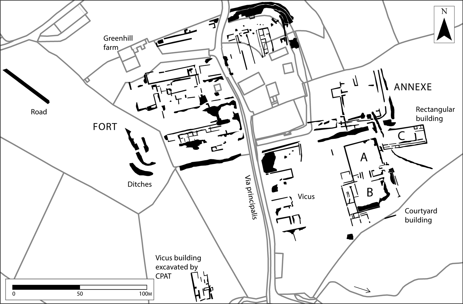
Pen y Gaer lies on a slight knoll, about halfway between the forts of Brecon Gaer and Abergavenny, some 2 km east of Bwlch and c. 500 m north of the modern A40. Though its remains were first recorded in the early nineteenth century,Footnote 7 the site's precise nature remained unresolved until small-scale excavations in 1966 examined what proved to be the north-eastern defences of a Roman fort, said to have been occupied during the period a.d. 80–130.Footnote 8 While additional data about the defences were forthcoming from aerial photography in 1975,Footnote 9 there the matter largely rested until the extramural areas were subjected to geophysical survey in 2005–06.Footnote 10 Areas north-west and north-east of the fort revealed only sporadic activity, whereas the two fields on its southern side, west of the modern lane, produced evidence indicative of extramural settlement, more than likely fronting the western side of a road leading south from the fort (fig. 1). A possible building, identified c. 100 m south of the fort (Area A), was also investigated in 2007.Footnote 11 Further details emerged from continued excavations in 2011–12 (Areas B and C), extending both the 2007 trench and examining two further areas at right angles to the modern lane.Footnote 12 Buildings were identified in all the excavated areas, some multiphase, suggesting a degree of settlement longevity. Detailed dating will depend on an assessment of the finds, though it has been suggested that activity might have extended from the later first to later second century.Footnote 13
Plan of Pen y Gaer as known prior to 2018 aerial photographs (after Jones and Hankinson Reference Jones and Hankinson2012, fig. 1, with minor amendments). (Courtesy of Clwyd-Powys Archaeological Trust)

The RCAHMW photographs, taken in 2018, together with those recorded by Mark Walters of Skywest Surveys when the site was subsequently overflown with a drone, have radically transformed this picture (figs 2–4). Details of the fort plan are now much clearer, demonstrating that it enclosed c. 1.6 ha (3.9 acres) and faced east; various internal structures are also visible, including part of the principia, two probable barrack blocks arranged per scamna in the north-eastern corner of the praetentura and at least two more within the retentura, this time aligned per strigas. Far more significant, however, is the new detail that has emerged about the fort's extramural adjuncts, hitherto only certainly established west of the modern lane. Three distinct areas can be discerned: the settlement area south of the fort; a walled annexe; and a complex of buildings outside and south of the annexe.
Pen y Gaer: general view of fort and related features from the east, taken on 19 July 2018. (Crown Copyright: RCAHMW AP_2018_5578)

Pen y Gaer: plot of cropmarks revealed on aerial photographs (drawn by Toby Driver). (Crown Copyright RCAHMW, Ordnance Survey licence number: 100022206)

Pen y Gaer: vertical drone photograph of major extra-mural buildings, north to the right, taken on 26 July 2018. (Courtesy of Mark Walters, Skywest Surveys)

It is now clear that extramural activity south of the fort also extended east of the modern lane. Here, several stone-built rectangular buildings are visible, their gable ends facing on to what was presumably an extension of the fort's via principalis, which would have functioned as the principal road within the civilian vicus. The excavations to the west in 2007 had already shown that similar buildings extended at least 100 m south of the fort, with subsidiary streets set at right angles to the presumed road. Pen y Gaer thus parallels the situation at many other forts, a pattern which will be discussed further below. No significant settlement features were recorded in the photographs along the fort's northern and north-eastern sides, where geophysical survey had also proved unproductive.
Along the fort's eastern and south-eastern sides, however, where little activity had previously been recorded, significant new discoveries included a walled annexe and a series of large buildings. The single-ditched, walled annexe, attached to the fort's eastern side, extended up to 56 m along the southern side of the presumed extension of the via praetoria. It contained at least one stone building. While any interpretation of its character and function is somewhat hampered by the overlying vegetation, one possibility might be a freestanding bath-house outside the porta praetoria; elsewhere, such a location could be occupied by a courtyard building and an associated bath-house, though here there does not seem to be adequate space for such a combination.
Outside the annexe, and separated from it by what may be a road following the line of its south-eastern defences, lay at least two and possibly three large structures, which are clearly discrete from the rest of the civilian activity to the west; taken together as a distinctive group, they currently have few parallels among the extramural buildings known at other forts in Wales (fig. 4). At the northern end lies a courtyard building, measuring c. 28 by 25 m, with a range of rooms across its southern side (area A on fig. 3). This is apparently linked to a second courtyard structure immediately to the south, measuring c. 42 by 33 m, with a central yard bounded by ranges of rooms along its western, southern and eastern sides (area B). The drone photographs suggest that they may be part of a single complex. To the east of the northern building, and set at a slightly oblique angle, is a rectangular, multi-roomed structure aligned east–west (area C). Measuring 34 by 15 m, it apparently had a ‘corridor’ along its southern side and one large and three smaller rooms at its eastern end. Such evidence raises intriguing questions about the nature and function of such buildings at Pen y Gaer and at other sites across Wales and the Marches, and beyond.
WIDER IMPLICATIONS FOR EXTRAMURAL ACTIVITY (see fig. 5 for Welsh sites mentioned in text)
Any discussion of the implications of this new evidence from Pen y Gaer is necessarily hampered by the absence of all but small-scale excavations at the site and by a similar lack of any recent large-scale work in the extramural areas associated with other forts across Wales and the Marches. What evidence there is, however, has an enormous potential to inform us about the character and development of extramural complexes during the critical Flavian to Trajanic era in Britain, by way of comparison and contrast with the better-known but later complexes in the northern part of the province; it is equally important because parallel data from early sites across southern England are very patchy, though the recently discovered timber buildings outside the Neronian to early Flavian fort at Okehampton in Devon offer some interesting points of comparison in terms of their location and plan.Footnote 14
Fortresses: 1. Caerleon; 2. Chester; 3. Kingsholm and Gloucester; 4. Usk; 5. Wroxeter. Forts: 6. Abergavenny; 7. Blackbush Farm; 8. Brandon Camp; 9. Brecon Gaer; 10. Cefn Brynich; 11. Brompton/Pentrehyling; 12. Bryn y Gefeiliau; 13. Buckton; 14. Cae Gaer; 15. Caerau (Beulah); 16. Caer Gai; 17. Caergwanaf; 18. Caer Gybi; 19. Caerhun; 20. Caernarfon; 21. Caerphilly; 22. Caersws I (Llwyn-y-brain); 23. Caersws II; 24. Canon Frome/Stretton Grandison; 25. Cardiff; 26. Carmarthen; 27. Castell Collen; 28. Castlefield Farm, Kentchurch; 29. Clifford and Whitehouse Farm, Clifford; 30. Clyro; 31. Coelbren; 32. Colwyn Castle; 33. Credenhill; 34. Forden Gaer; 35. Gelligaer I and II; 36. Hindwell Farm; 37. Jay Lane; 38. Leighton; 39. Llandeilo; 40. Llandovery; 41. Llanfor; 42. Llanio; 43. Loughor; 44. Monmouth; 45. Neath; 46. Pen-llwyn; 47. Pen Llystyn; 48. Pennal (Cefn Gaer); 49. Penydarren; 50. Pen y Gaer; 51. Pumsaint; 52. Rhyn Park; 53. Stretford Bridge; 54. Tomen y Mur; 55. Trawscoed; 56. Whitchurch; 57. Wonastow; 58. Wiston. Fortlets: 59. Brithdir; 60. Erglodd; 61. Hafan, Llanerfyl; 62. Hirfynydd; 63. Penmincae; 64. Pen y Crocbren; 65. Rheola Forest; 66. Waun-ddu (Y Pigwn III) (after Burnham and Davies Reference Burnham and Davies2010, fig. 1.9, with amendments; drawn by Hubert Wilson, Dyfed Archaeological Trust).

Two aspects of the new evidence from Pen y Gaer are particularly striking. The first is the self-evident separation of the three distinct elements of the fort's extramural adjuncts – the annexe, the likely civilian settlement and what would seem to be discrete official structures – which must surely imply oversight in the overall planning and layout of the different areas. The second is the presence of a distinctive complex of buildings to the south of the annexe, which must have exercised specialised functions within a wider landscape. Both aspects raise interesting questions about the picture elsewhere, both in Wales and beyond. The recognition of some sort of spatial separation is not entirely new, however. In an earlier discussion of extramural settlement, the authors had already noted a very similar threefold split at Caerhun and elsewhere, as well as a tendency for likely official buildings to occupy discrete locations away from the zones of civilian activity, which generally straddled the main roads extending out from the fort.Footnote 15 That study did not specifically consider the question of fort annexes, as they were clearly seen as being, for the most part, an integral feature of the military or official sphere of operations;Footnote 16 the only exception to this concerned those sites where the annexe could be shown to house substantial official structures. The importance of such annexes in a Welsh context has, however, featured in a recent discussion of the annexe and related features at Slack, which has done much to redress the imbalance.Footnote 17 In what follows, each of the discrete elements will be treated separately, before moving on to explore the function and wider implications of the various large building complexes.
ANNEXES
The walled annexe at Pen y Gaer clearly occupies a discrete location along the southern side of the road forming an eastward extension of the via praetoria, well away from the presumed civilian activity outside the porta principalis dextra. Its relatively small size and the presence of at least one internal stone building makes it highly likely that its origin and function should lie in the military or official sphere. It should be emphasised, however, that the precise relationship between the fort, walled annexe and building has not been tested by excavation, so their relative chronology must remain uncertain; in this respect, Pen y Gaer does not stand alone. Across Wales and the Marches the evidence now clearly indicates that annexes of one form or another were especially common from the later first century onwards. Indeed, of the 34 forts included in table 1, some 20 have now produced either clear or suggestive traces of at least one attached annexe (some have two), most self-evidently discrete from any of the areas characteristically associated with civilian activity, which typically lay outside at least one of the other gates of their respective forts.Footnote 18
DATABASE OF MILITARY SITES ACROSS WALES AND THE MARCHES

* Other fort sites from Burnham and Davies Reference Burnham and Davies2010 not included, as evidence for vicus, annexes and buildings either unproven or uncertain: Blackbush Farm; Brandon Camp; Cae Gaer; Caergwannaf; Caerphilly; Canon Frome/Stretton Grandison; Canon Frome Bridge; Castlefield Farm, Kentchurch; Clifford; Clyro; Colwyn Castle; Credenhill; Gelligaer I; Llandeilo I; Jay Lane; Leighton; Leintwardine; Monmouth; Rhyn Park; Stretford Bridge; Wiston.
While it is difficult to characterise all the examples, some trends are apparent. Where their overall size can be determined, the vast majority are smaller in relative terms than their respective forts; one of the smallest, at Caerhun, is only 0.17 ha, while the larger of the two at Pennal encloses 0.68 ha.Footnote 19 In a handful of cases, as at Pen y Gaer, relatively small annexes only occupy part of one side of the fort; those known at Caer Gai (that on the south-western side),Footnote 20 Caerhun,Footnote 21 Llandeilo IIFootnote 22 and Tomen y MurFootnote 23 seem to be largely devoid of any significant internal activity, much like the two successive (if slightly larger) annexes on the north-eastern side at Pennal.Footnote 24 A more distinctive group extended across the whole of one side. In the case of those at Abergavenny,Footnote 25 Caersws I and II,Footnote 26 Cefn Brynich,Footnote 27 Pen LlwynFootnote 28 and Pen LlystynFootnote 29 the evidence for internal activity is at best limited and so its precise character and status remains uncertain. By contrast, similar annexes at Bryn y Gefeiliau (represented by the retentura of the original fort),Footnote 30 Buckton,Footnote 31 Caer Gai (that on the south-eastern side)Footnote 32 and Pennal (that on the south-western side)Footnote 33 have all been shown to have housed a distinctive architectural complex, comprising both a bath-house and a substantial courtyard building; the annexe at Pen y Gaer also contained at least one stone building, as did that on the southern side at Hindwell Farm,Footnote 34 while the secondary annexe at Gelligaer II incorporated a bath-house and one other complex of uncertain character.Footnote 35 In all these cases the location of the annexe, well away from the apparent areas of civilian activity, and the character of the associated buildings would seem to indicate that they belonged in the official rather than the civilian sphere. As will become clear below, however, such buildings are also found as freestanding elements at other sites, which raises interesting questions as to what factors determined why some were defended and others not.
Two exceptions need closer scrutiny. One is represented by the Neronian fort at Hindwell Farm, where recent excavation has suggested that the civilian activity to the east of the fort was enclosed within a defensive circuit, represented by a triple-ditched enclosure and the remains of a possible gateway.Footnote 36 If correctly interpreted, this would seem to represent a surprisingly early example of a defended vicus of the type discussed at Slack,Footnote 37 though the curving nature of the circuit is unusual and might indicate a civilian rather than an official enterprise in an exposed military location. The second example is represented by the apparently larger annexe located on the north-eastern side of the fort at Caerau, which (among other structures) also enclosed a substantial courtyard building and a probable bath-house, all discrete from the main focus of civilian settlement on the north-western side;Footnote 38 though issues remain over the precise character of the presumed defences along its north-western and north-eastern sides, if correctly identified as an annexe (rather than a simple boundary ditch), then its extent and some of its internal elements might suggest that it was also designed to enclose an additional area of civilian settlement. Were it not for the meandering nature of the ditch along the western and northern sides of the fort at Caerhun, this might have been considered in the same light.Footnote 39
In general there appears to be no absolute preference for the location of these different annexes. Of those where it is possible to establish the direction in which the fort faces, nine had annexes outside the porta praetoria, seven had them outside the porta decumana, while only three and one respectively were located outside the porta principalis dextra and porta principalis sinistra, precisely those sides that were especially favoured when it came to the location of most extramural occupation; this point will be explored further below. The absence of any locational preference is particularly evident in the case of the smallest of the annexes. Interestingly, however, of the eight forts with annexes incorporating one or more large building, five lay outside the porta praetoria (Buckton; Caer Gai; Hindwell Farm; Pennal; Pen y Gaer); this clearly indicates a specific preference for this particular location, which was also favoured for several similar freestanding, but unenclosed, structures. Only two forts had similar annexes and buildings outside the porta decumana (Bryn y Gefeiliau and Caerau), while that at Gelligaer was located outside the porta principalis dextra.
While much has been written about the location and function of annexes, a good deal of it with reference to those on the Antonine Wall, the overwhelming impression from the Welsh evidence suggests that, with few exceptions, they should belong exclusively in the military or official sphere of operations: the majority are all relatively small; they are frequently located on a different side of the fort from that occupied by the recognisable civilian settlement; many have revealed limited, if any, trace of internal settlement activity, and, where there is evidence, its status remains somewhat ephemeral or uncertain; some were clearly designed, however, to enclose substantial buildings and/or bath-houses to the exclusion of any other structures. With the possible exceptions of Hindwell Farm and Caerau, none conforms to the evidence recently rehearsed at Slack, where the annexe clearly enclosed a defended vicus. This evidence is very much in line with that presented by C.S. Sommer and W.S. Hanson, both of whom conclude that, without evidence to the contrary, such annexes should be seen as discrete from any associated extramural civilian settlement and that the two elements were almost certainly designed to serve very different purposes.Footnote 40
CIVILIAN SETTLEMENT
Both the geophysical and aerial surveys at Pen y Gaer have shown clearly that a discrete area of extramural activity developed along the road extending south of the fort's porta principalis dextra. The overwhelming impression is of a series of strip-buildings arranged end-on to the frontages, some of which have been shown by excavation to have been associated with small-scale industrial activity. There can be little doubt that this represents an undefended civilian vicus of a type well known elsewhere in Britain and beyond.Footnote 41 Of the 34 forts included in table 1, some 20 have produced definite or suggestive evidence for comparable extramural settlements extending along one or more of the approach roads, while the precise character and status of the activity at a further five remains uncertain; at the remaining nine the apparent absence of settlement evidence to date should not necessarily be taken as evidence of absence in the past.
While much of the evidence for specific sites in Wales and the Marches has been well covered elsewhere,Footnote 42 a few general points might usefully be rehearsed here. First, as at Pen y Gaer, such extramural vici consistently take the form of discrete ribbon settlements extending along one or more of the roads leading out from their respective forts. In this respect they clearly conform to two of the characteristic types identified by Sommer,Footnote 43 though of these the street or ribbon type is cumulatively more common across Wales than his tangent type. Typical examples include the early site at Hindwell Farm,Footnote 44 the short-lived fort at LlanforFootnote 45 and the developed complexes at Brecon Gaer,Footnote 46 Caerau,Footnote 47 Caer Gai,Footnote 48 Caerhun,Footnote 49 Llanio,Footnote 50 Pennal,Footnote 51 Tomen y MurFootnote 52 and Trawscoed,Footnote 53 some with additional internal streets and lanes. With the enigmatic early exception of Hindwell Farm (and less certainly Caerau), none of these extramural vici can be shown to have been set within a defended enclosure.
A second point concerns the location of such extramural vici. Where this can be reliably assessed from table 1, it exhibits a marked (though not exclusive) preference for one or other of the portae principales: these latter together account for some 17 examples – nine and eight respectively outside the porta principalis dextra and porta principalis sinistra – followed by six examples outside the porta praetoria and only three outside the porta decumana. Such a preference clearly reinforces the point, already noted above, that vici and annexes either lay on different sides of their respective forts or were sufficiently discrete one from the other to indicate that they operated in different spheres; this latter aspect is particularly well attested at Pennal, where the line of the road leading out from the porta decumana (and therefore its associated settlement) was clearly determined and deflected by two apparently successive, but otherwise empty, annexes.Footnote 54 While the preference for one or other of the portae principales no doubt partly reflects official oversight and control, it should be remembered that such vici were also focused on the main approaches by which incoming traffic would have gained access both to their respective forts and thereby to the granaries.
A third aspect concerns such issues as internal layout, patterns of land use and the nature of the internal buildings. Given the importance of the road frontages in such ribbon-type settlements, it is no surprise to find that they were the focus of intensive occupation, a point consistently reinforced by aerial photography, geophysical survey and limited excavation. Several trends are apparent:Footnote 55 the dominant impression is one of large numbers of rectilinear plots or structures arranged end-on to the frontages, which thereby maximised the number of properties in the available space; where discernible or excavated, many of the associated structures tend to be strip-buildings, often with evidence of small-scale industrial activity; such buildings often stand at the street end of an associated plot or yard extending away from the frontage, perhaps with a boundary marker towards the rear. A typical example at Caerau should suffice to avoid unnecessary repetition: geophysical survey here has revealed just such a layout, with plots extending up to 30 m away from the road frontages, over a distance of c. 150 m north-west of the fort's porta principalis dextra, with numerous anomalies indicating the presence of substantial hearths.Footnote 56
One further distinctive feature at Caerau is the absence of any obviously larger buildings within what can be characterised as the extramural vicus, as these are otherwise found discretely located to the north-east, within a possible annexe outside the porta decumana. This reinforces the separation already noted at Pen y Gaer and raises interesting questions which are explored below.
OFFICIAL BUILDINGS
In their previous discussions the authors chose to treat larger buildings – principally courtyard structures and bath-houses – as integral elements alongside their respective vici, though they recognised that their location was not infrequently peripheral or secondary to the main areas of settlement.Footnote 57 The discovery of a very distinctive complex of buildings to the south of the annexe at Pen y Gaer, again clearly discrete from the extramural vicus, must surely reinforce the need for a reassessment of such issues as location and potential function, not just here but more widely across Wales and beyond. As table 1 emphasises, however, this is not an easy task, particularly where details about the plan and location of the different extramural components remain uncertain in the face of limited excavation.
Despite the difficulties, it is still possible to detect some distinctive trends. The presence of various courtyard buildings and bath-houses, whether in combination or independently within what must be official fort annexes, needs no further discussion here, except to note the preference for their location outside the porta praetoria; rather, our primary interest must be the presence of similar such buildings (presumably with similar functions?) as apparently freestanding, but unenclosed, elements within the extramural fabric of their respective forts. The porta praetoria was certainly favoured in several other cases: at Tomen y Mur, for instance, a bath-house and what has been identified as a possible courtyard structure lay on the south-eastern side of the fort,Footnote 58 while at Caerhun a bath-house lay outside the eastern side of the fort, with a larger building of uncertain plan to the north.Footnote 59 In both cases they lay on a different side to that on which the extramural vicus was located. Freestanding bath-houses not infrequently occupied similar locations outside the porta praetoria: examples include Caernarfon,Footnote 60 Caersws II,Footnote 61 Castell Collen (outside the south-eastern corner of the fort)Footnote 62 and Llanio;Footnote 63 this might also be the case at Penydarren.Footnote 64 In some cases, however, no doubt conditioned in part by the availability of the water supply, such baths lay outside other gates, as may have occurred at Abergavenny,Footnote 65 LlandoveryFootnote 66 and Pumsaint.Footnote 67 In virtually all these examples, the chosen location lay on a different side to that on which the extramural vicus lay.
Of particular interest in this context is the discovery at Pennal of a second possible courtyard building (in addition to that in the south-western annexe), lying immediately outside the porta principalis dextra, south-west of the road extending through the vicus.Footnote 68 An equally interesting group of buildings has also been recognised at Brecon Gaer, all of them lying immediately outside the fort's porta principalis sinistra, west of the road extending through the vicus: two are known from R.E.M. Wheeler's excavations, one with a complex of rooms of several phases around a central hall or courtyard (Building B) and the other said to be a bath-house (C); geophysical survey has added a second courtyard structure east of Building B, set back c. 25 m from the extramural road.Footnote 69 With the complex of buildings at Pen y Gaer in mind, it might also be worth noting that within the presumed annexe at Caerau, north-east of the fort, at least three buildings are represented in the geophysics; they comprised not just a courtyard building and possible bath-house, but also a long rectangular building with traces of numerous internal partitions, particularly along its north-eastern side.Footnote 70
Several other possible buildings are noted in table 1, but in most cases their plan is too poorly known for detailed discussion here. Enough has been said, however, to indicate that the majority of the examples discussed above were located in peripheral or secondary locations, either discrete from areas occupied by the extramural vici or else set back from the immediate frontages of the external roads. This must surely indicate that their location was primarily determined by their military or official associations, rather than by any desire to integrate them within the fabric of the extramural settlements; it must surely also have had a bearing on their wider functions, a point that is considered further below. In the absence of excavation at all but a handful of sites, however, the possibility should not be discounted that the location of some of these buildings was conditioned by their secondary date, meaning that they had to occupy such land as was available at the time;Footnote 71 that this was certainly the case with courtyard/bath-house complexes elsewhere across the province is considered further below.
EXPLORING THE NATURE OF OFFICIAL BUILDINGS
In trying to understand the nature of the different buildings at Pen y Gaer and of other, potentially official, complexes across Wales and the Marches, it is important to acknowledge that very few have been the subject of any extensive excavation. This raises two significant problems, which inevitably provide a rich harvest for speculation without the assurance of any certainty; the effort should, however, identify useful lines of enquiry which, in turn, might help to spur the direction of future research. The first problem concerns the difficulty of identifying the specific function(s) of the various buildings now known to us, even when their plans are ‘reassuringly’ well defined from extensive geophysical survey. The second, and perhaps more pressing, issue arises from the difficulty of establishing even the relative chronology of the different buildings vis-à-vis other elements in the overall plan, whether that be fort, annexe or vicus. Both aspects are considered below.
FUNCTION
In the absence of explicit documentary or epigraphic evidence, assigning a specific function to the different categories of building discussed above is no easy task. Most problematical of all are the various non-standard building types, which will probably always defy definitive functional classification on purely archaeological grounds. In the case of the relatively common bath-houses, it is reasonably clear that most, if not all, began life to serve the garrisons of their respective forts and that, where they did not accrue any other functions, their occupation and demise mirrored those of their parent installations. The situation is more complex, however, where they were located alongside other substantial building complexes, as this raises questions about the extent to which they were contemporary in origin or necessarily changed roles and acquired new functions during their lifetime.
The most distinctive of the structures are the courtyard buildings, whether enclosed within an annexe or set outside the fort defences, which are not infrequently found in association with bath-houses. They are, of course, examples of a common architectural type that, depending on the individual context and circumstances, was flexible enough to function as a market complex or as a military, official or urban residence; more importantly, for our purposes, several province-wide examples have also been interpreted as official, custom-built accommodation, or mansiones, providing facilities associated with the imperial cursus publicus.Footnote 72 While this latter is an attractive hypothesis for some of the Welsh material, it needs to be treated with caution in individual cases, as any identification is ultimately dependent upon analogy to sites elsewhere in the province, which are deemed to incorporate a range of distinctive archaeological features of varying dates.
Parallels for some of the Welsh courtyard buildings might fruitfully be sought in the frontier zones of northern Britain, though it should be borne in mind that military activity in this area long outlasted the second quarter of the second century, by which time the bulk of the Welsh garrison had been withdrawn. The number of such buildings that have been plausibly identified as potential mansiones is surprisingly small, however, while details of their chronology often remain slight. Particular interest necessarily attaches to the later first-century complex identified at Newstead, where a stone courtyard building lay within an annexe attached to the Flavian fort's western side, fronting the porta praetoria;Footnote 73 it was probably also originally connected to a walled enclosure to the east, containing a bath-house and latrine.Footnote 74 Somewhat later in date is the complex identified within the annexe of the Antonine fort at Camelon; this included a bath-house and a second stone building, the latter set at an oblique angle.Footnote 75
Elsewhere in the north, the most likely candidates are rarely closely datable and often exhibit complex sequences of development. A clearly defined stone courtyard building is visible on aerial photographs at Old Carlisle, lying south of the fort and a branch road from the porta principalis dextra, where it is manifestly a separate entity from the vicus.Footnote 76 Geophysical survey at Carvoran has revealed two large masonry buildings outside the fort's eastern gate, one apparently of courtyard plan and both discrete from the vicus which straddles the line of the Stanegate to the south.Footnote 77 A similar survey at Chesters also revealed a masonry building of apparent courtyard plan, occupying an area between the fort and the bath-house, discrete from the vicus to the SSW.Footnote 78 At Manchester a substantial masonry building is known in the vicus.Footnote 79 Where dating evidence is available, such courtyard buildings seem to be relatively late in the development sequence. At Lancaster, for instance, E. Black has assigned a large courtyard building with baths, located to the north of the second-century fort, to the later third century, apparently succeeding several second- to third-century phases of timber building of uncertain plan.Footnote 80 Likewise, at Catterick, the courtyard building was only constructed c. a.d. 160, though it too succeeded an earlier structure of indeterminate plan.Footnote 81 More problematical is the multi-phase stone building with an attached bath-house at Vindolanda, which lay within an annexe, cheek by jowl with other buildings; originally identified as a mansio, thought to have been built in the mid- to later second century, it has more recently been reinterpreted as the praetorium of a Severan fort.Footnote 82 Doubts have also been expressed about the identification of another possible structure outside the fort at Benwell on Hadrian's Wall.Footnote 83
It is noteworthy that extensive geophysical surveys at other forts in northern England – Maryport, Birdoswald, Housesteads, Halton Chesters and High RochesterFootnote 84 – have not revealed any evidence for substantial stone buildings potentially identifiable as mansiones. This does not rule out the possibility that they were of timber construction or that relevant facilities were housed in less well-defined types of building, either of which could help to explain their apparent absence. While excavation is said to have located a possible timber example of Hadrianic date at the Pennine fort of Melandra Castle, where occupation came to an end early in the Antonine period, there is some uncertainty as to its status.Footnote 85 Another possible example in the east vicus at Greta BridgeFootnote 86 has been reinterpreted as two strip-buildings, which makes better sense given their later replacement in stone.Footnote 87
Only further work will clarify whether the apparent scarcity of such courtyard complexes in the north simply reflects the vagaries of our current knowledge or, more likely, that purpose-built accommodation was only selectively provided across the military network, at key points on the main arterial roads. The same might arguably be true in Wales, for which table 1 tentatively lists only nine probable and two possible examples, representing at best 33 per cent of the garrison posts.
Similar purpose-built courtyard buildings, often associated with a bath-house, have also been identified in the civilian zone of the province, where they have been interpreted as part of a concerted programme of construction at roadside settlements, consequent upon a reform of the cursus under Hadrian. Well-known examples include those excavated at ChelmsfordFootnote 88 and Godmanchester,Footnote 89 and that visible on aerial photographs at Wanborough,Footnote 90 to which might be added the later examples at WallFootnote 91 and Whitchurch;Footnote 92 all five are characteristically set well back from the main road frontages so as not to impinge on land otherwise occupied or available for the resident population. This is not the place to discuss such buildings in detail; it is enough to note that Black has suggested that the adoption of a courtyard plan was not commonplace before the mid-second century,Footnote 93 while elsewhere the evidence indicates a much more diverse range of plans being employed over a lengthy time span extending into the third and fourth centuries. What links them together is their location on key arterial routes connecting London to key administrative centres and the military zones of the province, along which soldiers, civilians and supplies were constantly moving. Interestingly too, as A. Smith and M. Fulford have recently emphasised, many of the same roadside settlements were later provided with defended circuits, clearly reflecting their continuing importance along the main roads, even if earlier purpose-built accommodation had sometimes ceased to operate.Footnote 94
While some of the potentially official complexes across Wales and the Marches might well have been connected with the provision of facilities associated with the cursus publicus, other possibilities should also be considered, including a role in local administration and policing, the collection, storage and transport of supplies and taxes, and the oversight of mineral exploitation, with or without a significant military presence. While potentially attractive in individual cases, such identifications are rarely capable of proof. Elsewhere in the province, the presence of various officials and seconded soldiers is well attested in the epigraphic record,Footnote 95 among them three cases of a centurio regionarius, various beneficiarii consulares, a single singularis consularis and two cases of a strator consularis, not least (though not exclusively) at various forts and settlements on the main roads leading north from York. Interestingly, at Catterick, a beneficiarius consularis rededicated an altar that had originally been erected by a singularis consularis to the ‘god who devised roads and paths’;Footnote 96 while this could be plausibly interpreted as indicating oversight of the cursus and the security of the roads, elsewhere the precise function of such officials remains a matter of much discussion. Unfortunately, no such officials are attested in the epigraphic record for Wales and the Marches, which makes any further speculation problematic.
Sadly, none of this provides conclusive evidence to help us understand the functions of the specific buildings identified at Pen y Gaer, let alone those at other sites across Wales and the Marches, though it would seem to emphasise the potential significance of the road network as a focus for ongoing military and official functions; as such, it offers some useful lines of enquiry, which are explored further below.
CHRONOLOGY
The review of potential British parallels has clearly shown that, whatever the precise function of the various building complexes, the requirement for them long outlasted the second quarter of the second century, by which time a significant number of the Welsh forts and their associated vici had ceased to be occupied.Footnote 97 This is not the case everywhere, however: several key forts certainly survived for varying durations beyond the reign of Hadrian, often with a reduced garrison; a few sites have also revealed renewed, military activity or interest in the later third/fourth century, and yet others have produced an enigmatic tail of activity in the form of small quantities of finds extending into the later second century (and sometimes beyond). It is essential, therefore, to explore such chronological evidence as currently exists with respect to individual forts, vici and official buildings, not least because they may well exhibit quite different occupation sequences of relevance to the wider themes under discussion here. This is no easy task, given the differential levels of excavation that have been undertaken at each.
A particular problem surrounds the dating of the major building complexes, because (bath-houses apart) few of the key structures have ever been explored. Independent bath-houses present few problems, as they generally reflect the chronology of their respective forts. For the larger courtyard complexes, evidence is confined to a handful of cases only. At Bryn y Gefeiliau, the building was clearly a secondary feature, occupying an annexe formed out of the retentura of the original Flavian fort when it was reduced in size; this seems to have occurred c. a.d. 120, as the new structure overlay earlier levels that extended down to that point at least. While the fort seems to have gone out of use c. a.d. 140 at the latest, a small amount of later material associated with the stone building points to continuing activity on this site through to the end of the second century at least (and perhaps beyond), well after the demise of the military phase.Footnote 98 Interestingly, this dating brings it into line with the earliest phase of the timber structure at Pentre, in north-eastern Wales, which comprised three ranges of rooms, most probably associated with a lead-working complex,Footnote 99 and those buildings of periods 5B–6 within the south-eastern corner of the fort at Caernarfon, which Black considers to be the functional predecessors of the Antonine courtyard building.Footnote 100
Further south, at Pennal, small-scale work in the south-western annexe located two phases of timber buildings beneath one of the stone structures with a hypocaust; this raises the tantalising possibility that the courtyard building and, less certainly, the bath-house were secondary features in the life of that part of the annexe,Footnote 101 even if their chronological relationship to it remains untested. Though the absence of samian beyond a.d. 160 suggests that the fort may have gone out of use by that date, despite it never having been the subject of any excavation, small-scale work in the vicus has shown that occupation certainly continued there into the later second century, while several sherds of later pottery from the topsoil would seem to point to a tail of activity into the third century.Footnote 102 The situation is somewhat clearer at Brecon Gaer, where one of the two possible courtyard buildings, which also included a heated suite (Building B), is certainly datable to the early to mid-second century, though a somewhat longer usage is suggested by the recovery of several mid-third-century coins from the area, all this in association with a functioning fort.Footnote 103
Such evidence, though potentially significant, cannot easily be extended to other sites, where little or no excavation has been directed at the relevant building complexes. In a few cases a secondary date might be indicated by their location in peripheral areas of the settlement, away from the main road frontages, but it would be unwise to depend on this as there may be other factors at work. Instead, it is necessary to rely upon such dating evidence as is available from either the forts or their extramural vici, as a proxy for identifying sites with activity extending into the later second century and beyond. It is easiest to begin with the forts where military activity definitely continued, principally because the details have already been well rehearsed and fully referenced elsewhere.Footnote 104 At least five – Brecon Gaer, Caernarfon, Caersws II, Castell Collen and Forden Gaer – have all produced clear evidence for military activity extending down to the Severan era, though it may have been on a reduced scale from levels in the Antonine period; the same has also been claimed at Abergavenny. Thereafter, several sites have produced material evidence for later third- and fourth-century activity. Such evidence clearly betokens continued military occupation, which is also reflected in the rebuilding or maintenance of defences and internal buildings at Brecon Gaer, Caernarfon, Castell Collen, Forden Gaer and probably Loughor and Neath. At both Caersws II and Castell Collen, the forts were eventually abandoned at the close of the third or beginning of the fourth century; at Brecon Gaer there is plentiful numismatic material as well as evidence of changes to the fortified perimeter with occupation continuing into the reign of Gratian (a.d. 367–75); at Forden Gaer it took the form of a substantial refortification in the Valentinianic era, after a long phase of abandonment; at Caernarfon the occupation continued to the last decade of the fourth century. More enigmatic is the evidence from the forts at Neath and Loughor, though in both instances at these southern forts it can plausibly be interpreted as reoccupation in the context of coastal defence in the period c. a.d. 275–330 on the basis of numismatic evidence; this is also probably the case at Cardiff, where a ‘Saxon Shore’ type fort (Cardiff IV) was established sometimes after the mid-third century.Footnote 105 Of all these, only one at Brecon Gaer has so far produced evidence that might be identifiable as two courtyard buildings and a possible bath-house outside the defences.
At other fort sites the evidence is much more problematic, as several have produced material evidence for a tail of activity extending into the later second century at least, and sometimes beyond, though it is not always easy to decide whether this is military or civilian in character. This might provide support for the view that some of the official-looking building complexes could have had a role after the abandonment of their respective forts, hence the urgency of exploring them with a targeted programme of excavation. A tail of activity at Pennal has already been discussed above. A similar tail of activity has also been suggested at Caer Gai, where the fort seems to have gone out of use in the later Hadrianic period; small-scale work in the vicus, however, has recovered coarseware sherds from the uppermost levels of a yard, datable to the later part of second century.Footnote 106 At Caerhun, in north Wales, where occupation inside the fort probably ended prior to c. a.d. 160,Footnote 107 the recovery of a few Constantinian to Valentinianic(?) coins from the excavations,Footnote 108 as well as a scatter of mostly unstratified later pottery, might relate to renewed (or continuing?) activity at a key river crossing on the route to Caernarfon.
In south Wales, a similar picture emerges at several sites. At Pen y Gaer, the site that forms the starting point for this paper, military activity most probably ended during the reign of the emperor Hadrian or slightly later; small-scale excavations within the vicus, however, have suggested that some of its buildings continued to be occupied into the later part of the century.Footnote 109 Further west, much the same sequence is identifiable at Llandovery, though here the latest sherds indicate activity continuing into the third century at least, at what was a key site on the road network.Footnote 110 While military activity ceased within the fortlet at Pumsaint in the early a.d. 120s, occupation certainly continued for a generation or so south of the river, in the vicinity of the bath-house excavated in the 1830s, perhaps in association with the nearby gold mines; even later activity is represented by a pottery assemblage from the mine area, which includes both samian of the second half of the second century and coarsewares extending down to the later third century, if not beyond. The presence of a burnt timber building, dating to the later third or early fourth century, inside the fortlet perimeter might also represent a renewed military or official interest in the site.Footnote 111 Rather more enigmatic is the fort at Gelligaer II, which was founded in the first decade of the second century and is unlikely to have lasted beyond c. a.d. 160. Later activity is indicated, however, by small amounts of later pottery of the late second and mid-third/fourth centuries,Footnote 112 while the annexe was only added at a late date, as its defences overlay the heavily silted fort ditches; this latter may have been a focal point for later activity, though its precise relationship with the bath-house and another complex of uncertain character remains uncertain.Footnote 113
Interestingly, several of these sites with a tail of activity also possessed major building complexes, often including at least one courtyard building and a bath-house, hence the urgency of clarifying their chronology. Three other sites might also be mentioned here – at Buckton, Caerau and Tomen y Mur – if only to note that the only dating evidence is derived from their respective forts, all of which went out of use during the Hadrianic period; as a consequence, nothing is known about their extramural buildings, which is especially unfortunate at Caerau, where at least three buildings are represented in the geophysics.
The explanation for such later Roman activity or material is most likely to be multi-causal: a military presence, whether long-term or spasmodic in character, represents one clear thread, with personnel involved being potentially few in number, perhaps concerned with policing duties or the collection of taxes and the annona militaris from the later third century; the defensive perimeter could have been used conveniently, even in a decayed condition, to provide a ready-made enclosure for the temporary corralling of livestock; the presence of official buildings, potentially mansiones, might represent the continued provision of facilities along major routes into the later period, even after the cessation of their respective forts and of most, if not all, the related activity in the extramural vicus; some such buildings might also have served an administrative or marketing function, or at least as a focus for such activity in the later Roman period. Sadly, in the absence of any inscriptions recording the presence of relevant officials, there is no easy way of judging between competing options. These aspects are developed in the next section.
COMMUNICATIONS AND CONTROL ACROSS WALES AND THE MARCHES?
Despite the difficulty of identifying specific functions over time, one recurring feature common to most, if not all, sites, seems to be the ongoing significance of the communications network and such interrelated activities as the cursus publicus, policing and tax collection. This aspect is explored in detail by Black and has recently been reinforced by Smith and Fulford with respect to the province as a whole.Footnote 114 The situation in the northern military zone might be instructive in this respect. Here, the plausibly identified or suspected mansiones all lie on key routes, several of which have also produced milestones indicative of their continuing upkeep and importance.
East of the Pennines, the key route north of York, via Catterick, to Corbridge and thence northwards to Newstead and Camelon during the second century was certainly studded with custom-built facilities at most of these sites, no doubt alongside lesser provision at other fort sites. The continued upkeep of this route is further emphasised by the discovery of several milestones, with examples at Aldborough, Piercebridge, Lanchester and Corbridge.Footnote 115 West of the Pennines, known installations at Manchester and Lancaster both lie on key north–south routes, with a northern terminal at Carlisle. Here too, milestones are known from Castleford, Lancaster, Ribchester, between Ribchester and Borrow in Lonsdale, Brougham, Old Penrith and near Carlisle, testifying to their continued upkeep;Footnote 116 another route from Carlisle via Old Carlisle to the fort at Maryport has a single milestone.Footnote 117 The Stainmore route linking Catterick to Carlisle has also produced milestones at Greta Bridge and Bowes, though custom-built facilities are currently lacking.Footnote 118 The maintenance of the Stanegate and probably the Military Way is also attested;Footnote 119 unsurprisingly, custom-built facilities have been plausibly recognised at Corbridge, Chesters, Carvoran and Old Carlisle. The relative ubiquity of milestones along both the York to Corbridge and the Stainmore roads, in particular, is clearly indicative of their long-term importance. By contrast, the lack of milestones from other trans-Pennine routes, coupled with the virtual absence of garrison bases in this area in the later Roman period, must surely be linked.
Such evidence might provide a plausible model for considering the situation across Wales and the Marches, where it might be hypothesised that most traffic in the post-Hadrianic period might have been constrained to the prioritisation of ‘arterial’ routes, linking key nodes such as the civitas centres, the legionary fortresses and those military and official installations that remained in use (fig. 6).Footnote 120 This might supply a plausible explanation for both the buildings and the extended occupation at Pen y Gaer, which would have lain on one such strategic route. Evidence in support of this might be drawn from two sources: the routes recorded in the third-century Antonine Itinerary and the incidence of milestones. Iter XII in the Antonine Itinerary from Carmarthen to Wroxeter lists Caerleon, Burrium (Usk) and Gobannium (Abergavenny), all three on road RR62a, and Magnis (Kenchester) on RR6c; thence RR6a continued to Chester via Whitchurch. The status of Usk is unclear, though coinage indicates a settlement of uncertain character on the ex-fortress site to the mid-fourth century.Footnote 121 Abergavenny too appears to be a settlement of some significance after the apparent abandonment of the fort, certainly by the mid-third century, and has a coin list to the reign of Valentinian.Footnote 122 It may be no accident that these two places are listed, since both may represent spontaneous(?) settlement growth in the lower Usk valley, possibly with a role in the marketing and supply of the legionary base downstream, while Kenchester ranks as a vicus in Dobunnic territory, fulfilling both a marketing and administrative role.Footnote 123
Communications and control: main sites mentioned in the discussion in relation to the road network (after Burnham and Davies Reference Burnham and Davies2010, fig. 4.3, with amendments; drawn by Hubert Wilson, Dyfed Archaeological Trust).

Although Abergavenny is the most northerly place mentioned on RR62a, it is clear that the road, and by implication places along its course, was maintained further north and west (RR62a, b). This seems to be confirmed by the presence of several milestones. One stone, found c. 8 km south-east of the fort at Brecon Gaer, bears the titles of Constantius Chlorus and Constantine II,Footnote 124 while another to the west at Trecastle Hill bears the titles of Postumus and Victorinus,Footnote 125 indicating road maintenance at the time of the Gallic Empire. It has already been noted that Brecon Gaer has produced extensive coinage and ceramics of the mid-third to mid-fourth century, as does one of the enigmatic stone buildings north of the fort. Given that Pen y Gaer lies equidistant between Brecon Gaer and Abergavenny, could one of the stone buildings outside that fort have been occupied as a long-lived mansio/administrative focus, long after the parent fort and vicus had been abandoned in the Antonine period? It should also be noted that there is evidence in the form of a milestone, now lost, from near Dinevor,Footnote 126 bearing the titles of the emperor Tacitus (a.d. 275–76), indicating that the road continued to be maintained west to Llandovery and thence south-west into the Tywi valley on its way to the civitas centre at Carmarthen (RR623b); Llandovery is another site that has produced a small amount of late Roman ceramics, perhaps connected to the presence and continued usage of at least one stone building, of uncertain plan and function, close to the long-abandoned fort. Beyond this, to the north-east, along RR62c, lies Pumsaint, where activity in the second century and beyond may indicate continuing interest in the nearby Dolaucothi gold mines.
Such ideas might be extended to other routes. In north Wales, road RR67a–c from Chester to Caernarfon also shows continuity of maintenance as an arterial route, both in Iter XI of the Antonine Itinerary, with at least one intermediate stop at Canovium (Caerhun), and in the form of three milestones: one stone found near Bangor bearing the titles of Pertinax and Caracalla,Footnote 127 another seven miles west of Caerhun with those of Constantine IFootnote 128 and a third found east of Caernarfon with the titles of Trajan Decius (a.d. 249–51).Footnote 129 Once again, the late activity at Caerhun is unsurprising in this context. Likewise, in south Wales, RR60a–d from Caerwent to Carmarthen unsurprisingly shows a similar continuity of use as might be expected from a road linking two civitas centres as well as the legionary base at Caerleon. Iter XII from Carmarthen to Wroxeter mentions Leucarum (Loughor), Nidum (Neath) and Bomium (Cowbridge); the latter is a roadside settlement with activity extending into the fourth century,Footnote 130 while the former pair have demonstrated renewed, probably military-related interest in the later third and early fourth centuries at least; the late fort at Cardiff also lay along the route. A notable cluster of seven milestones has also come from the vicinity of Neath/Port Talbot south to Pyle; their texts span the reigns of Gordian III to Licinius, with a concentration in the period of the Gallic Empire.Footnote 131
Such evidence provides a plausible explanation for the link between an ongoing upkeep of key arterial routes across Wales and those sites that betray either military activity or a tail of activity (with or without the presence of potential official buildings) extending beyond the Hadrianic era. It does not, however, explain all the sites that fall into the latter categories. Prime among these is the fort and settlement at Caersws II, which occupies a key location in central Wales, at the western end of RR64 from Wroxeter, via Forden Gaer, a route along which no milestones are yet known. Caersws does, however, lie at the focus of a road network that connects it to several key sites: via RR642 to Caer Gai and thence via RR64b to Tomen y Mur and other sites in Snowdonia; more than likely via RRX63, perhaps as far as Pennal on the Dyfi estuary; and probably via RRX58a and RR623a to Castell Collen, Caerau and ultimately Llandovery. The presence of several major building complexes at all these sites must surely reinforce the importance of these routes, irrespective of any evidence for milestones; this latter might be explained by a change in circumstances in the later period, which led to a relative decline in their significance.
There might also be evidence for a continuing interest in controlling access to mineral resources in north-west Wales; certainly, the buildings in the reused retentura at Bryn y Gefeiliau have been plausibly linked with mineral extraction and processing,Footnote 132 while the large courtyard building in the south-eastern corner of the fort at Caernarfon has also been linked to an official with oversight of mineral exploitation.Footnote 133 A similar case has been made above for the building at Pentre. One final possibility at Caerhun and Pennal is their location close to navigable estuaries, which might have been convenient points for the transhipment of goods around the Welsh coast. One anomalous site remains to be mentioned. At Buckton, a fort with an associated courtyard building and bath-house, which was apparently abandoned c. a.d. 130, is somewhat oddly located 1.5 km west of the known north–south road. This does not conform easily with the pattern discussed so far, though Black has suggested that this may be because it was succeeded by roadside facilities at nearby Leintwardine.Footnote 134
However speculative this discussion might be, given the problems of functional and chronological clarity, it does at least point a way forward for future research.
AGENDA FOR FUTURE RESEARCH
Much valuable detail has clearly been provided in recent years as a result of Cadw's ‘Roman Fort Environs Project’ and the RCAHMW's aerial photographic surveys. Where and when possible, such work should continue. Aerial photography is particularly well suited to the needs of recurrent monitoring at the better-known forts and their extramural adjuncts, especially during periods of extended drought, both to enhance existing detail and to identify distinctive new features in the overall layout and planning. Drones could also play a useful role by virtue of their relative cheapness and application on a near day-by-day basis. Such monitoring might usefully be complemented, where possible, by enhanced geophysical survey, though this may need to be more focused than hitherto on specific forts and areas within them, in order to sharpen an understanding of key issues concerning the relative importance of major building complexes, particularly at those sites that have an extended period of occupation.
Such surveys can only take us so far, however, in moving from a state of speculation to one of greater clarity. In the Welsh context there is now an urgent need for a programme of targeted excavation with the following aims and objectives:
(1) to establish the relative chronologies of the different elements, whether forts, annexes, extramural vici or official buildings;
(2) to clarify the nature of the late military sequences at those forts that survived beyond the Hadrianic period, as well as the extent of the related internal occupation and size of the resident garrisons;
(3) to sample the major building complexes, in particular, to determine their individual dating sequences relative to their parent military installations and other extramural activity, to explore their ground plans in more detail and to clarify any points of comparison and contrast; this is especially relevant to questions such as the potential presence of any timber predecessors and their respective functions over time;
(4) to seek to explain why some building complexes were enclosed within annexes while others were not, as this might be a question of function, chronology, convenience or perceived threat; specific attention might also be directed at those sites with more than one example of a large courtyard building, especially when one such structure is located inside an annexe and the other outside, often peripheral to the main vicus;
(5) to trace the courses of the less well-known routes leading out from such key sites as Caersws II, as these must have been important connections to sites further north-west, west and south, where there is evidence of ongoing activity and the presence of large building complexes;
(6) to clarify the character, function and relative chronology of the diverse range of annexes now known, not least where, as in many cases, they seem to be bereft of any visible internal structures; this obviously has a wider relevance in view of the importance of annexes at many other forts across Britain.
On a wider front, such a programme might also facilitate the recovery of a range of cultural and environmental data, which could potentially contribute to some of the wider research themes and questions that now form the focus of contemporary Romano-British archaeology. Looking even further afield, many of the themes discussed in this paper are equally relevant to, and invite comparison with, better-known sites in other frontier contexts. One line of research, which might prove especially fruitful, would be a detailed analysis of the ground plans of the various official and mansio-type buildings across Britain and beyond, not least because much useful and relevant comparative material has recently come to light in Gaul;Footnote 135 this has an obvious potential for the Welsh sites under discussion here, but might also contribute to updating Black's analysis within a wider continental dimension. In turn, this might help to clarify both the role of the military in constructing such buildings in the military zone and their precise functions with respect to the cursus publicus and related activities.
ACKNOWLEDGEMENTS
The authors would like to acknowledge the assistance of Toby Driver, on whose aerial photographs of Pen y Gaer this article is based. They are also grateful to the following organisations and individuals for permission to publish the following illustrations: Clwyd-Powys Archaeological Trust for fig. 1; RCAHMW for figs 2 and 3; Mark Walters of Skywest Surveys for fig. 4. figs 5 and 6 were prepared by Hubert Wilson of Dyfed Archaeological Trust, through the auspices of Ken Murphy. Helpful comments were provided by the two anonymous reviewers.