1. Introduction
Travertine deposits provide unique records of hydrological systems. Although travertine is common worldwide in a variety of hydrological settings, of particular interest are those occurrences linked to tectonic activity and extensional fault systems (Barnes, Irwin & White, Reference Barnes, Irwin and White1978; Hancock et al. Reference Hancock, Chalmers, Altunel and Cakir1999), such as many deposits in the western USA (Chafetz & Folk, Reference Chafetz and Folk1984; Newell et al. Reference Newell, Crossey, Karlstrom, Fischer and Hilton2005; Crossey et al. Reference Crossey, Fischer, Patchett, Karlstrom, Hilton, Newell, Huntoon, Reynolds and de Leeuw2006). The geochemistry of travertine-depositing mineral springs along major structural features suggests that deeply sourced, or endogenic, CO2-rich water exploits faults and fractures and later travels to the surface (e.g. Yoshimura et al. Reference Yoshimura, Lui, Cao, Yuan, Inokura and Noto2004). This acidic water dissolves surrounding carbonate rock so that, upon reaching the surface, it degasses and leads to precipitation of carbonate in the form of travertine. Present models of hydrological systems that source travertine springs include mixing of varying proportions of shallowly circulated meteoric (epigenic) water with deeply sourced and circulated endogenic water (Crossey et al. Reference Crossey, Fischer, Patchett, Karlstrom, Hilton, Newell, Huntoon, Reynolds and de Leeuw2006). In these models, small contributions (a few per cent) of deeply sourced water can significantly influence the geochemistry of a groundwater body (Newell et al. Reference Newell, Crossey, Karlstrom, Fischer and Hilton2005; Crossey et al. Reference Crossey, Fischer, Patchett, Karlstrom, Hilton, Newell, Huntoon, Reynolds and de Leeuw2006).
In addition to being a regional indicator for tectonic activity and hydrological variation, travertine deposits considerably impact the local geomorphology in the landscapes where they occur. They can locally reduce the sediment budget of fluvial systems by mantling relict fluvial deposits and entombing sediment so that it cannot be eroded. Travertine deposits have the potential to alter the course of a river by prograding across a river floodplain, thereby restricting the flow path of the river. Some travertine deposits partially or fully dam rivers, such as Soda Dam in New Mexico (Goff, Reference Goff1987). This damming can cause lakes to form upriver of the travertine, or can cause avulsion of the riverbed (Pentecost, Reference Pentecost1993; Ford & Pedley, Reference Ford and Pedley1996). Also, since travertine can be dated using U-series geochronology, these deposits can be used as a chronological constraint on geomorphic features, such as river terraces (Pederson et al. Reference Pederson, Karlstrom, Sharp and McIntosh2002).
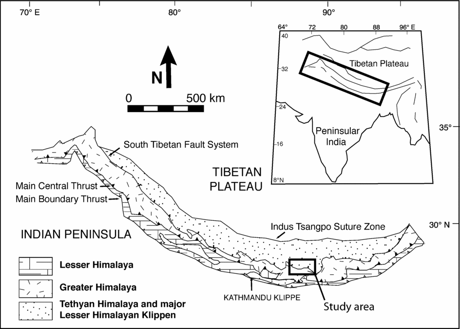
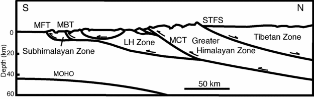
Herein we present data on a newly discovered travertine deposit that is located within the Tethyan Himalayan lithotectonic zone (Fig. 1), near the contact between the Tethyan and the high-grade crystalline rocks of the Greater Himalaya (Fig. 2). The travertine occurs along the trace of the upper strand of the South Tibetan Fault System, which is a major normal fault system that marks the southern boundary between the Tethyan and Greater Himalaya. We herein describe the characteristics of this travertine deposit, outline the geomorphological effects of travertine deposition, provide Sr isotope data of the travertine and the implications for fluid flow, and finally, provide uranium-series ages for the deposit that illustrate the manner in which it developed, and that potentially link travertine deposition to Holocene climate variability. This is the first known study for this region of the Tibetan Plateau. Previous work on travertine systems in Tibet include geochemical studies on active springs on the Tibetan Plateau further to the NE (Hoke et al. Reference Hoke, Lamb, Hilton and Poreda2000; Yokoyama, Nakai & Wakita, Reference Yokoyama, Nakai and Wakita1999), and one study dating travertine from Tingri, about 120 km northeast of Nyalam, that yielded an age of 100 ka (Sweeting, Bao & Zhang, Reference Sweeting, Bao and Zhang1991).
Regional lithotectonic map of the Himalaya with study area located approximately 30 km north of Nyalam, Tibet indicated in black box (after Myrow et al. Reference Myrow, Hughes, Paulsen, Williams, Parcha, Thompson, Bowring, Peng and Ahluwalia2003).

Simplified structural cross-section of the Himalaya. STFS – South Tibetan Fault System, MCT – Main Central Thrust, MBT – Main Boundary Fault, MFT – Main Frontal Thrust.

2. Geological history
In southern Tibet, along the northern flank of the Himalaya, Neoproterozoic to Eocene marine deposits of the Tethyan Himalaya lie in contact with the crystalline rocks of the Greater Himalaya (Fig. 2) across the South Tibetan Fault System. Tectonic fabrics and structures in the rocks of the Greater Himalaya, and E–W-trending, S-vergent folds in the Tethyan strata, indicate an initial phase of southward transport along the South Tibetan Fault System consistent with crustal shortening (Burchfiel et al. Reference Burchfiel, Zhiliang, Hodges, Yuping, Royden, Changrong and Jiene1992). Subsequent extension occurred through low-angle, N-dipping normal faults (Hodges, Reference Hodges2000) and, potentially, through channellized flow of partially molten lower Tibetan crust (Bird, Reference Bird1991; Royden, Reference Royden1997; Nelson, Reference Nelson1996; Searle, Law & Jessup, Reference Searle, Law, Jessup, Law, Searle and Godin2006). Movement along the South Tibetan Fault System normal faults is predominantly down-dip to the north, although many locations also show oblique displacement (Pecher, Reference Pecher1991; Coleman, Reference Coleman1996).
The South Tibetan Fault System is well exposed at the study area north of Nyalam, Tibet. Here, the fault strikes NE and dips NW 20 to 30°, and cuts hanging-wall bedding at low angles (Burchfiel et al. Reference Burchfiel, Zhiliang, Hodges, Yuping, Royden, Changrong and Jiene1992). This fault rests in the same structural and stratigraphic position as the Qomolangma Detachment, the upper of two strands of the South Tibetan Fault System in the Everest region (Searle, Reference Searle1999; Searle et al. Reference Searle, Simpson, Law, Parrish and Waters2003). The footwall is made up of an injection complex of Cambrian quartzite and psammitic schist of the Rouquiecun Group (Burchfiel et al. Reference Burchfiel, Zhiliang, Hodges, Yuping, Royden, Changrong and Jiene1992). High-grade metamorphic rocks of the Rongbuk Formation underlie these strata across the lower strand of the South Tibetan Fault System, the Lhotse detachment (Searle, Reference Searle1999; Searle et al. Reference Searle, Simpson, Law, Parrish and Waters2003). All of these units are well exposed in the area and they have no travertine associated with them. Above the Rouquiecun strata, and just below the Qomolangma Detachment, is a 109 m thick foliated yellow- to orange-weathering, highly sheared limestone, which in the Everest region is commonly referred to as the ‘Yellow Band’ (Jessup et al. Reference Jessup, Law, Searle, Hubbard, Law, Searle and Godin2006). Above the fault contact on the hanging-wall is a thick succession of Ordovician limestone of the lower Chiatsun Group. The lower 105 m consists of intensely fractured blue-weathering limestone, and this is followed by 65 m of pink- to white-weathering deposits of a thrombolite reef complex.
3. Location
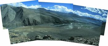
The travertine deposit described in this study is located on the NE side of a steeply incised river valley approximately 30 km north of Nyalam in southern Tibet. The valley is accessible by a dirt road that branches off the Friendship Highway to the west (Fig. 1), and the road crosses the travertine platform approximately 5 km west of the mouth of the valley (Fig. 3).
Photomosaic of travertine platform and T1 – Terrace 1, T2 – Terrace 2, AFT – alluvial fan toe.

The valley contains a high-energy braided stream that has cut down through bedrock and alluvial fan deposits. The fluvial deposits consist of winnowed gravel and cobble terraces. On the NE side of the river, river terraces are partially covered by alluvial fans that emanate from the steep valley wall. On the SW side of the river, river terraces are not extensive and in several places the river is in contact with vertically incised bedrock. Less than a kilometre upriver from the study area the valley widens considerably and the stream gradient lessens, so the study area represents a knickpoint in this fluvial system. This knickpoint also corresponds to where the upper strand of the STFS crosses the valley, juxtaposing the brittlely deformed Ordovician strata against ductilely deformed Cambrian sedimentary rocks. At this transition, there is a cliff about 100 m high where an alluvial fan on the southwest side of the valley is cut by the river. The surface of that fan projects to a similarly oriented surface across the valley to the northeast (Fig. 3).
The travertine platform is situated along the northeastern valley wall beneath outcrops of Ordovician carbonate. Only minor travertine deposits exist near the present river level on the southwest side of the river. Spring discharge was observed as seeps below the travertine platform on the northeast side of the river and from spring mounds on the southwest side of the river, and these springs were associated with recent travertine accumulations. Similar travertine deposits and active springs were observed, but not described by this study, along the Friendship Highway north of the study area and south of the ascent onto the Tibetan Plateau (N28°22.957, E086°6.507, 4376 m).
4. Methods
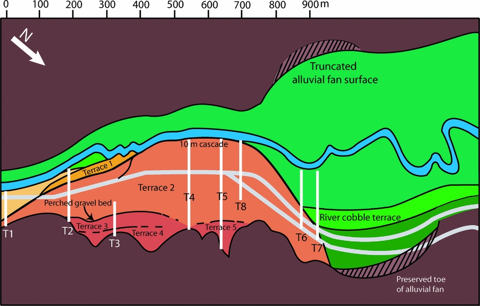
Samples were collected from sites across the platform, and from adjacent Ordovician limestone bedrock, for geochemical and petrographic analysis. In order to describe the morphology of the platform, we used a tape, Jacob staff and a level to conduct nine parallel cross-sections between the river and the valley wall (Fig. 4). These cross-sections were linked by a perpendicular transect that stretched the length of the platform. Along each cross-section we made careful descriptions of lithologies and textures. A brief description of the travertine textures of the platform are provided, but a detailed petrographic and petrological analysis is beyond the scope of this paper.
Map view of field area. Travertine platform is shown in orange, yellow and red. T1 through T8 are cross-sections, and grey lines are roads. Scale along top edge is distance in metres.

Powdered samples of travertine were analysed for mineralogical composition on a semi-automated X-ray diffractometer at Colorado College, and for carbon and oxygen isotopic analyses on a continuous flow Finnegan Mass Spectrometer at Colorado Plateau Stable Isotope Laboratory at Northern Arizona University. Strontium isotope analysis of ten travertine samples was carried out at the University of Illinois, Champaign–Urbana, using a Nu Plasma multi-collector ICP-MS. Samples representing a broad spatial distribution across the travertine platform and a variety of travertine textures were selected for 87Sr–86Sr analysis. A sample of Ordovician limestone taken in the cliff face above the travertine platform was also analysed. Small pieces of travertine were picked off each sample, powdered and dissolved in acid. The samples were then centrifuged to remove impurities, siliciclastic grains and clay minerals. They were flushed through columns of resin with strong acid to selectively leach strontium. Each sample was diluted and analysed on a plasma mass spectrometer for 87Sr/86Sr ratio.
Six samples of travertine were analysed at the University of New Mexico's Radiogenic Isotope Laboratory for U-series ages. For each sample, a small volume of travertine powder was drilled out of the most indurated layer that contained a minimum of siliciclastic material. Powdered travertine was dissolved in HNO3 and spiked with a mixture of 229Th–233U–236U. Anion exchange columns were used in two runs to separate U and Th after they were co-precipitated with pure FeOH3. Isotopic ratios were determined using a Micromass Sector 54 thermal ionization mass spectrometer (TIMS) with a high-abundance sensitivity filter and an ion-counting Daly multiplier. Age uncertainties in the ratios are 2 sigma of the mean and include those related to initial 230Th/232Th correction (4.4 × 10⁻⁶+50%) (Polyak & Asmerom, Reference Polyak and Asmerom2001). Data for the U-series analyses can be obtained from the authors upon request.
5. Mesoscopic features
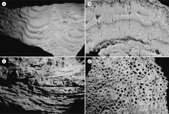
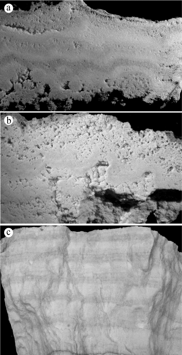
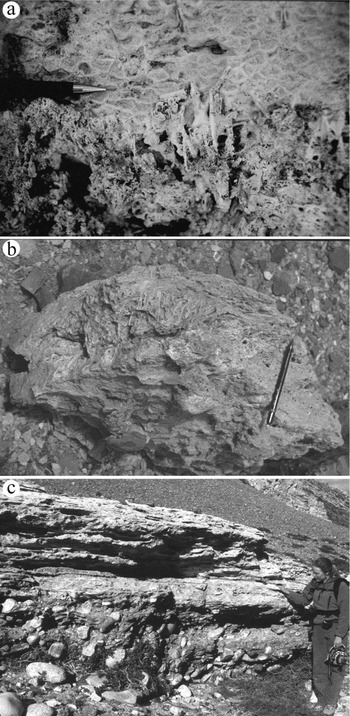
It is not evident from the field relationships whether the spring water that deposited the travertine platform emanated from one spring source or from several sources. The platform is characterized by a number of extensive terraces (cf. Mammoth hot springs: Chafetz & Guidry, Reference Chafetz and Guidry2003), across which variable chemical and physical conditions produced a wide variety of typical small- and large-scale travertine textures. One such texture (Fig. 5b) is defined by a series of 1–1.5 cm thick undulatory layers with granular and bladed calcite crystals that are locally arranged into poorly structured fans. Oncoids or pisoids (Guo & Riding, Reference Guo and Riding1998; Ford, Reference Ford and Middleton2003) are also present as nonaligned, concentrically laminated spheres that range from 1 to 15 mm in diameter (Fig. 6a). Foam rock (sensu Chafetz & Folk, Reference Chafetz and Folk1984) is present as networks of holes 2–3 mm in diameter on the upper surface of some travertine layers (Fig. 5d). The majority of carbonate at this site is laminated. Lamination styles include (1) repetitive layers of massive carbonate, (2) heteropachous alternations of light and dark laminae (Fig. 6c), and (3) cyclic repetition of dark laminae, micrite and crystal rays (Fig. 5b) (Pentecost, Reference Pentecost2005).
Travertine textures. (a) Microterrace texture (view is 15 cm). (b) Crystalline shrub texture (view is 5 cm). (c) Rhizoliths, specifically, casts of grass blades (view is 5 cm). (d) Sponge-like texture on the upper surface of a layer of travertine (width of field of view is 10 cm).

(a) Globular texture at the base of a slab (view is 6 cm). Layers of travertine draped over globules. (b) Porous shrub texture with alternating layers of porous and better-indurated calcite (view is 7 cm). (c) Clean carbonate texture (width of field of view is 10 cm).

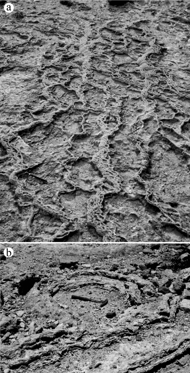
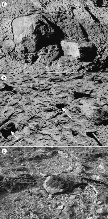
Dams are present at all scales. Microdams coat a variety of surfaces from near-horizontal to near-vertical (Fig. 5a). They are small, often parallel but sometimes anastomosing, stepped-down ridges with undulating crestlines. Each microdam is approximately 5 mm wide and 2 to 3 mm tall. Interdam distance ranges from 3 mm to several metres. Macrodams, also called terraced mounds (Chafetz & Folk, Reference Chafetz and Folk1984), rimstone pools (Warwick, Reference Warwick and Cullingford1953) and terracettes (Bargar, Reference Bargar1978), are shallow, flat pools between 0.5 and 2 metres wide and 1 to 3 metres long, which step down a few centimetres to adjacent pools (Fig. 7), and are commonly covered in microdams. The pools behind the macrodams in many cases contain eroded and redeposited travertine clasts (Fig. 7b). On the travertine platform along the margin of the alluvial fans, large blocks of bedrock are found surrounded by travertine (Fig. 8). The blocks range from 0.1 to 0.5 m in diameter. Some blocks are resting on top of the travertine as float (Fig. 8b), some are partially surrounded by travertine (Fig. 8a), and others are completely entombed within the travertine (Fig. 8c). Carbonate overgrowths on grass blades and plant stems (Pedley, Reference Pedley1987; Guo & Riding, Reference Guo and Riding1998; Klappa, Reference Klappa1980) confirm the presence of macrophytes during active deposition. These are observed in situ on a cliff face of travertine, 1 m above the present river level (Fig. 9a), and approximately 45 m southeast of the point where Transect 4 meets the river (Fig. 4). The shape and size of these encrustations (Fig. 5c) match those of living plants along the edge of the river.
Pools and ridges. (a) Flow direction was right to left and ridges are mantled with microterraces. Pencil is 14 cm long. (b) Large pool with clasts of reworked travertine and adjacent bedrock. Hammer is 37 cm long.

(a) Cobbles encased by travertine. Pencil is 14 cm long. (b) Angular to sub-rounded embedded blocks (arrowed) within pool and ridge textures. These blocks represent rockfall onto an active travertine-depositing flow. Hammer is 35 cm long. (c) Excavated clast with travertine coating (light coloured). Clast removed from hole below pencil.

(a) Rhizoliths in travertine beside the river. (b) Clast with rhizoliths and travertine-covered cobbles above Terrace 3 gravel bed. (c) Gravel bed underlain and overlain by travertine. Note rounded clasts and imbrication indicating flow from left to right.

A 1 m thick fluvial gravel bed exists at the base of Terrace 3, 18 m above the modern river level (Fig. 9c). The bed consists of clast-supported gravel, the basal 30 cm of which contains cobbles and boulders. The upper 70 cm of the bed is made up of poorly sorted sand- to boulder-sized gravel with rounded to subangular clasts. Platy clasts show excellent imbrication, indicating palaeoflow direction predominantly to the southeast, parallel to the modern river flow. Large, locally derived clasts, which contain part of both the top of the gravel bed and some travertine that mantled the gravel, exist on top of Terrace 3. These clasts, up to approximately 1 m long on their intermediate axes, exhibit grass encrustations in a matted texture (Fig. 9b).
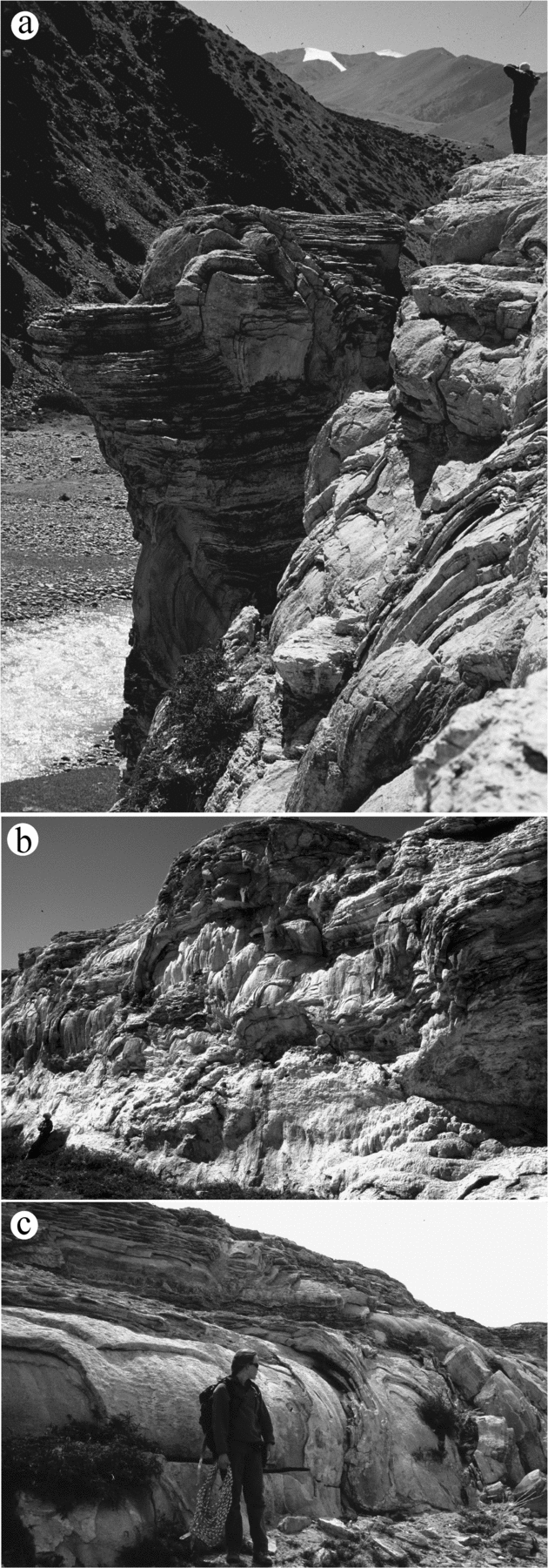
At locations where travertine terraces end and abruptly step down to a lower level, layers of laminated travertine drape the sharp change in slope. These cascade or waterfall facies (cf. Guo & Riding, Reference Guo and Riding1998) are preserved in some places on the edge of Terrace 2 (Fig. 10c), and are well exposed at the cliff where Terrace 4 meets the present river gravel bars (Fig. 10a, b). The cascade at Terrace 2 is between 0.5 and 1 m high. The cascade on the Terrace 4 cliff along the river is 10 m high at its highest point and appears to have mantled and prograded outwards from a 10 m tall fluvial gravel terrace that extends out from Terrace 4 to the NNW. The cascade features represent travertine deposition over the pre-existing topography of fluvial terraces. This is evident from the mantling of Terrace 2 over the large gravel terrace that extends NNW along the river.
Cascades. (a) 10 m tall cascade cliff at Transect 4 with metre-scale folds. Person for scale in upper right. (b) Face of large cascade cliff shown in (a). Folds with vertical travertine on the left; eroded face of cliff on right. This surface is the terminus of the travertine platform. Person for scale in lower left. (c) Well-developed cascade on Terrace 2.

6. Geomorphology
The travertine platform is located at a narrowing and steepening of the valley that corresponds with a knickpoint formed by the transition from brittlely deformed carbonate strata to ductilely deformed Cambrian rocks, across the upper strand of the South Tibetan Fault System. The growth of the travertine platform radially from a source or sources on the NE side of the valley has restricted the flow path of the river to a narrow channel pinned along the SW valley wall.
Fluvial and hillslope alluvial processes were incorporated into the travertine platform as active components of the evolving landscape. For instance, the gravel bed at the base of Terrace 3, which is overlain and underlain by travertine, represents a fluvial terrace deposit, based on its clast-supported nature, imbrication, and degree of rounding of the cobbles and boulders. This deposit is similar in character to gravel found along the modern river, and that in a 10 m thick gravel terrace NNW of the travertine platform. The presence of reed and grass encrustations in the large clasts of travertine that also contain river gravel (top of Terrace 3) indicate that the travertine entombed riverbank gravel and macrophytes, a process that is occurring along the banks of the modern river. The perched river gravel at the base of Terrace 3, and these encrustations in the overlying travertine, formed when the ancient channel and riverbank environment was 18–20 m above the current river level. This indicates that there has been at least 18 m of down-cutting during the lifespan of the travertine platform. The subsurface of the travertine platform was not explored in any manner, so it is unclear whether the river cut down through bedrock or previously deposited fluvial deposits, although we presume the latter. Both the perched gravel bed mantled by travertine Terrace 3, and the thick travertine cascade at river level (termination of Terrace 2) that mantles the 10 m thick fluvial gravel terrace deposit, show that travertine deposition and fluvial deposition were contemporaneous and operated over long time-scales. In addition, deposition of travertine over these gravel terrace treads entombed them and shielded them from further erosion. This process likely influenced the river's sediment budget during the long-term progradation of the platform. These processes are observed today, where the active spring seeps and mounds at river level are cementing modern river gravels.
Erosion and deposition along the walls of the valley also affected the travertine platform. In addition to the embedded rock falls described above, the toes of alluvial fans on the NE side of the valley locally prograded over the proximal parts of the platform (Figs 3, 4). The toe of a large alluvial fan that prograded from the southwest side of the river, and was later incised by the river, also rests on the platform (Figs 3, 4). Based on the present position of the river, and the fact that the terminus of the terrace is not eroded, as the travertine prograded across the river valley it forced the river to the far side of the valley (Fig. 3, 4). All of the features described above illustrate the potential for a travertine system to drastically influence a host of geomorphological processes.
7. Geochemistry
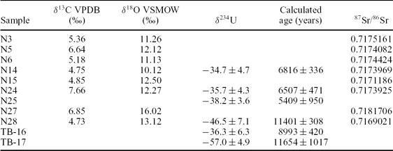
X-ray analysis indicates that all samples are entirely composed of low-Mg calcite. Complete analytical data for the 87Sr–86Sr and stable isotope analyses are availabale from the authors, and summary data are given in Table 1. δ13C values range from 4.73 to 7.66‰ (PDB) and δ18O values range from −14.45 to −20.17‰ (PDB). The relatively high δ13C values rule out alteration by interaction with soil CO2, as expected given the minimal soil development on the landscape. Fractionation (several per mil) to slightly higher values may have resulted either from evaporation or progressive degassing of CO2 during surface flow across the platform. The δ18O values for the travertines range from −20.2 to −14.5 ≈ (PDB). Using carbonate-water palaeothermometers (O'Neil, Clayton & Mayeda, Reference O'Neil, Clayton and Mayeda1969; Epstein et al. Reference Epstein, Buchsbaum, Lowenstam and Urey1953), palaeotemperatures for the springs are estimated to range from ∼9 to 25°C. For the calculation, we assume that meteoric water has not varied significantly over the Holocene and is representative of past spring water. Published δ18O values for High Himalayan rivers at elevations above 3000 m (−16 to −19 ≈ v. SMOW) (Gajurel et al. Reference Gajurel, France-Lanord, Huyghe, Guilmette and Gurung2006) are used as a proxy for local meteoric water. The calculated temperatures are consistent with active springs at the site (Newell et al. unpub. data), suggesting that the oxygen isotopes have not been significantly altered by diagenesis and that the springs responsible for the travertine platform were cool springs.
δ18O and δ13C isotopic composition, δ234U isotopic composition, calculated ages in years, and 87Sr/86Sr of the travertine

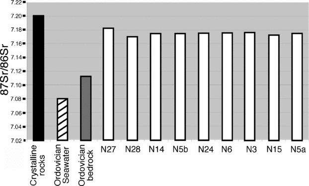
87Sr/86Sr ratios from the travertine platform range from 0.7169 to 0.7181 (Fig. 11; Table 1), and the Ordovician limestone has an 87Sr/86Sr ratio of 0.7112. The isotopic ratio of 87Sr/86Sr in a travertine reflects the geochemistry of the rocks through which the source fluids passed. In this area, the most likely source of carbonate is the steeply dipping Ordovician limestone in the hanging-wall of the South Tibetan Fault System, which is exposed directly above the platform and which extends deeply into the subsurface. Marine carbonate acquires the 87Sr/86Sr ratio of the seawater in which it forms (Veizer & Compston, Reference Veizer and Compston1974). The fluctuation in 87Sr/86Sr ratio in the global oceans through the Phanerozoic has been documented through analysis of marine carbonate, evaporite and phosphorite (Burke et al. Reference Burke, Denison, Hetherington, Koepnick, Nelson and Otto1982; Palmer & Elderfield, Reference Palmer and Elderfield1985; Elderfield, Reference Elderfield1986; Veizer, Reference Veizer1989). 87Sr/86Sr ratios ranged from 0.7090 in the Early Ordovician to 0.7079 in the Middle to Late Ordovician (Burke et al. Reference Burke, Denison, Hetherington, Koepnick, Nelson and Otto1982). Thus, the isotopic value (0.7112) from our Ordovician bedrock sample is anomalously high for marine carbonate, including the average for Ordovician strata. The isotopic values of the travertine (0.7169 to 0.7181) are even higher than those of the Ordovician bedrock. This eliminates the possibility that the spring was fed directly by meteoric waters that only dissolved limestone bedrock. The radiogenic nature of the travertine Sr isotopic ratios indicates that somewhere on the flow-path, spring waters passed through radiogenic bedrock. Siliciclastic and metasedimentary deposits are generally associated with high Sr ratios due to the radioactive decay of 87Rb to 87Sr. Sr ratios range from 0.702 to >0.780, depending on the age of the rocks and their composition (Faure & Powell, Reference Faure and Powell1972; McNutt, Reference McNutt, Cook and Herczeg2000). The rocks of the Greater Himalaya, an injection complex of Neoproterozoic psammitic schist and leucogranite (Rongbuk Formation), as well as the Cambrian quartzite and psammitic schist in the footwall of the South Tibetan Fault System, would contribute a radiogenic signature to fluids passing through them.
87Sr/86Sr ratios for sampled travertine, local Ordovician bedrock, average Ordovician seawater, and an estimate for crystalline rocks in the area (from Faure & Powell, Reference Faure and Powell1972).

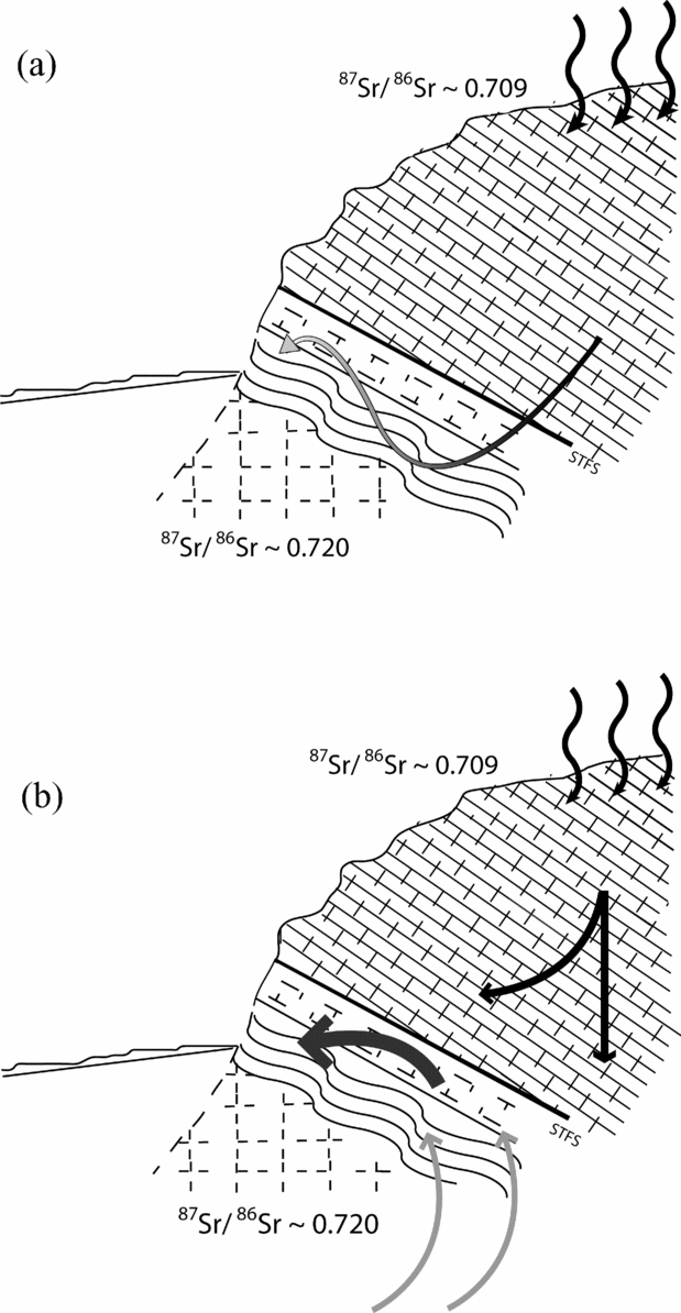
In this study we present two possible end-member fluid-flow models (Fig. 12). In the first, meteoric water travelled to depth and was then brought to the surface along a fracture or fault system, possibly related to the South Tibetan Fault System. In the second model, meteoric water percolated down through the highly fractured Ordovician limestone and mixed with rising endogenic fluids from a deeper hydrological system that was in equilibrium with Greater Himalayan crystalline bedrock. Endogenic fluids can arise from deep sources, including geothermal systems related to magmatism, mantle devolatilization and crustal metamorphism, and mixing of even small amounts can significantly alter the geochemistry of travertine-depositing mineral springs (Liu et al. Reference Liu, Zhang, Li and You2003; Crossey et al. Reference Crossey, Fischer, Patchett, Karlstrom, Hilton, Newell, Huntoon, Reynolds and de Leeuw2006). Both hydrogen and oxygen isotopic analyses of present-day spring water at the study site indicate that it is mostly meteoric (Newell, unpub. data), so that endogenic input is in fact volumetrically minor. The disproportionately large effect of small volumes of endogenic fluid has been shown to be important for travertine developed along prominent fault zones in the southwest USA (Newell et al. Reference Newell, Crossey, Karlstrom, Fischer and Hilton2005; Crossey et al. Reference Crossey, Fischer, Patchett, Karlstrom, Hilton, Newell, Huntoon, Reynolds and de Leeuw2006). Both models imply that all or a portion of the fluid would have interacted with the Greater Himalayan crystalline rocks that lie below the Tethyan Himalayan sedimentary sequence in the footwall of the South Tibetan Fault System.
End-member models for the hydrological system that fed the travertine depositing spring. (a) Surface water reached shallow depths, and acquired a radiogenic isotopic signature from interaction with Greater Himalayan rocks. STFS – South Tibetan Fault System. (b) Small volume of endogenic water rising along the South Tibetan Fault System from great depth passed through the Greater Himalayas and mixed with meteoric waters to produce elevated 87Sr/86Sr ratios.

Intermediate values for the Ordovician limestone suggest that it has been diagenetically altered. The limestone is highly fractured to allow for fluid flow. Therefore, it is likely that fluid carrying a radiogenic signature due to interaction with the Greater Himalayan rocks may have permeated the limestone along fractures and faults, and elevated its 87Sr/86Sr ratios.
The thick accumulation of travertine implies movement of CO2-charged waters, and their degassing at the surface (Zhang, Zhang & Zhu, Reference Zhang, Zhang and Zhu2001; Chen et al. Reference Chen, Zhang, Wang, Tangfu and Ronggui2004). One possible source of the CO2 is biological degradation of organic matter in soils. However, the relatively dry climate and very poor soil development in this region, in combination with the high δ13C values for the travertine, rule out this possibility. Candidate processes posed for other mineral springs, including those in the Tibetan Plateau, include metamorphic decarbonation of carbonate rocks, magmatism, or mantle devolatilization (e.g. Hoke et al. Reference Hoke, Lamb, Hilton and Poreda2000; Yoshimura et al. Reference Yoshimura, Lui, Cao, Yuan, Inokura and Noto2004; Newell et al. Reference Newell, Crossey, Karlstrom, Fischer and Hilton2005). The lack of present-day magmatism and the extremely thick crust in the region argues against the presence of significant mantle fluids. High carbon isotope values support our interpretation for the input of the CO2 from crustal metamorphic decarbonation reactions.
Basement-penetrating normal faults are often associated with travertine deposits (Barnes, Irwin & White, Reference Barnes, Irwin and White1978; Hancock et al. Reference Hancock, Chalmers, Altunel and Cakir1999). In our study area, a travertine platform accumulated along the strike of the Qomolangma Detachment, the upper strand of the South Tibetan Fault System, where it crosses a river valley, precisely where Ordovician carbonate rocks of the Tethyan Himalaya crop out in the hanging-wall. CO2-charged fluids utilized the South Tibetan Fault System as a fluid pathway, dissolving carbonate rocks along the fault zone and redepositing them as travertine at the surface. Deep penetration of the South Tibetan Fault System into high-grade rock of the Greater Himalaya may have allowed for mixing of high-volume meteoric recharge with more deeply sourced CO2-charged endogenic water, similar to what has been documented in the southwestern USA (Newell et al. Reference Newell, Crossey, Karlstrom, Fischer and Hilton2005). Circulation of surface water to relatively shallow depths in the footwall of the South Tibetan Fault System could also have elevated the isotopic ratios, but this is unlikely because it does not explain the high levels of deeply sourced CO2 needed in the spring water to produce the travertine.
8. U-series dating
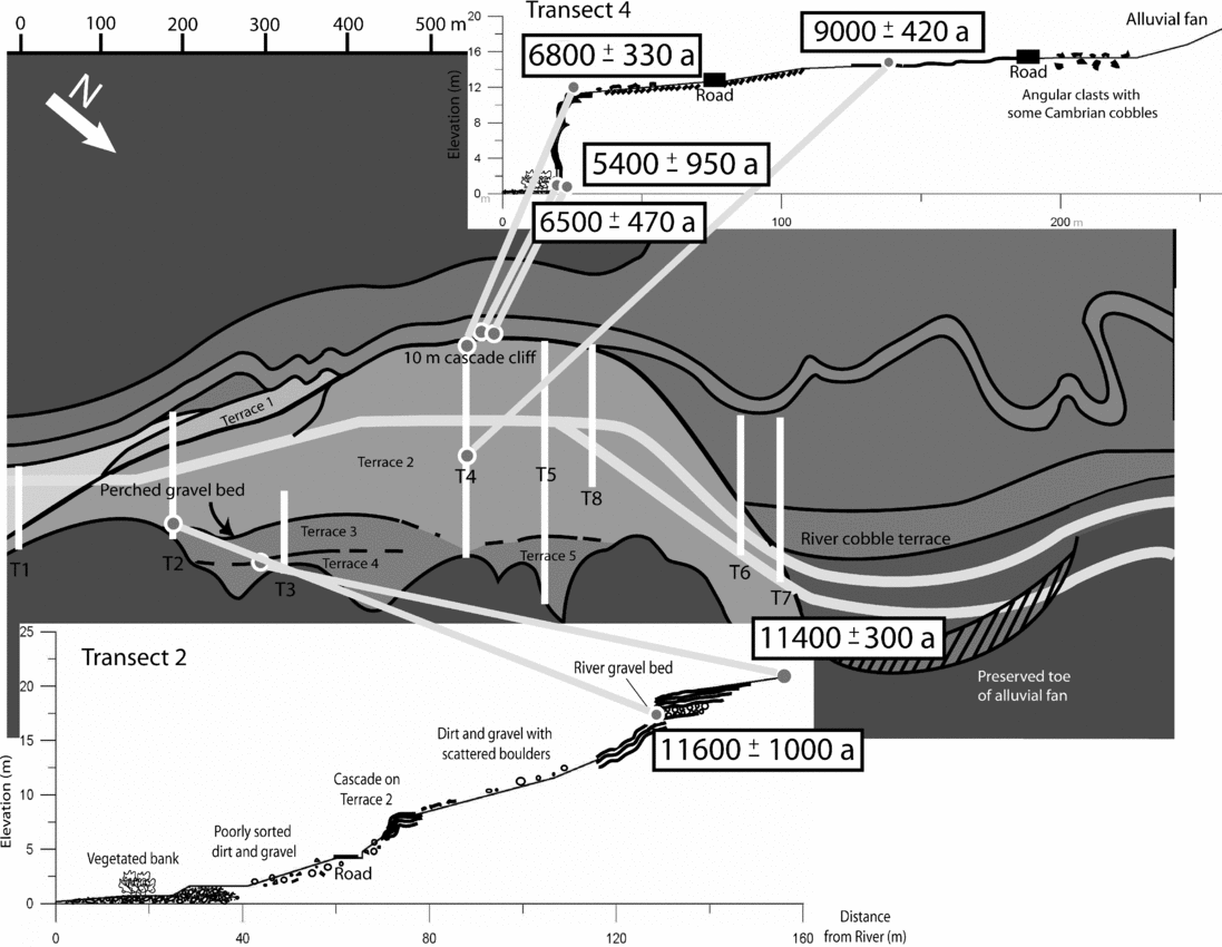
The travertine samples range in age from 5400 a (±950 a) to 11600 a (±1000 a) (Fig. 13). The oldest travertine sample, N28, was taken relatively proximal to the likely source spring(s), from a high elevation on the platform (6 m below the highest recorded travertine). It was collected from the top of Terrace 3, southeast of Transect 3, and records a U-series age of 11400 a (±300 a) (Fig. 13). Sample TB17 was taken from the top of the perched gravel bed along Transect 3, approximately 1 m stratigraphically below N28, and its calculated age is 11600 a (±1000 a). Sample TB16, collected from the top of Terrace 2, yielded an age of 9000 a (±420 a). Sample N14 was collected at the top of the 10 m tall cascade on Transect 4 and records an age of 6800 a (±330 a). Two samples, N24 and N25, were taken from the most distal part on the platform (closest to present-day river position), at base of this cascade, and these yielded ages of 6500 a (±470 a) and 5400 a (±950 a), respectively. In summary, the data show sequentially younger ages moving across the travertine platform from the highest terrace against the valley wall toward the present river level.
Map of sampling locations with associated U-series dates. Scale along top edge is distance in metres.

8.a. Interpretation
The pattern of ages provides insight into the timing and development of the travertine platform. The highest travertine terrace (Terrace 4) on the platform, developed along the valley wall, yielded the oldest U-series ages. Terraces successively lower in elevation and closer to the modern river record progressively younger travertine ages. This pattern suggests that the travertine likely accumulated at the level of the local alluvial water table, initially at higher elevations along the edge of the alluvial fan, and that the spring source migrated as the river incised and local water table dropped. If the spring were fixed at one location, then the platform surface would have been mantled with young travertine and there would be no age progression in surface samples across the platform. Also, present-day spring activity and travertine precipitation is occurring at the stream level. Assuming that the deposition of river gravels and travertine cementation was relatively contemporaneous, the age of the travertine that directly overlies the river gravel of Terrace 3 indicates that the river channel and adjacent ecosystem of reed flora was about 18 m above the present river level at 11600 a. Although it is not possible to determine if incision since this time was solely within bedrock, these data would suggest a local incision rate of 1.6 mm a−1. Such a rate is reasonable given that fluvial incision rates in the High Himalaya are generally 4–8 mm a−1 (Lavé & Avouac, Reference Lavé and Avouac2001).
The range of uranium-series ages for this travertine platform suggest that the majority of platform growth occurred between 5400 a and 11600 a. In an arid climate where precipitation rates are low and overland flow is seasonal, it is likely that the bulk of travertine deposition occurred during wet climatic intervals when there was enough water available to allow for relatively high volume flow from the source spring(s). The period between 5400 a and 11600 a corresponds to a time of higher intensity in the Indian Ocean monsoon (Sirocko, Reference Sirocko1993), which could have elevated spring flow in this region of Tibet, and thus increased the volume and/or rate of travertine precipitation. Studies of ocean sediment cores from the Arabian Sea, lake-sediment cores, pollen assemblages, and landslide recurrence intervals in northwestern India, all record elevated precipitation levels during this time interval (Sirocko, Reference Sirocko1993; Enzel et al. Reference Enzel, Ely, Mishra, Ramesh, Amit, Lazar, Rajaguru, Baker and Sandler1999; Singh et al. Reference Singh, Joshi, Chopra and Singh1974; Bookhagen, Thiede & Strecker, Reference Bookhagen, Thiede and Strecker2005).
9. Conclusions
This study describes a previously undocumented travertine platform north of the town of Nyalam in southern Tibet at the transition from the Tibetan Plateau to the High Himalaya. A broad range of travertine textures (metre- to millimetre-scale) present correlate with those of modern, active travertine springs worldwide (Fouke et al. Reference Fouke, Farmer, Des Marais, Pratt, Sturchio, Burns and Discipulo2000; Pentecost, Reference Pentecost2005). Over time, contemporaneous travertine precipitation and fluvial deposition resulted in the cementation and capping of fluvial terrace gravels by travertine, which reduced the river's local sediment budget.
87Sr/86Sr ratios in the travertine require subsurface water–rock interaction with the radiogenic, crystalline rocks, such as those of the Greater Himalaya. We favour a model whereby large-volume meteoric recharge mixed at depth with relatively low-volume CO2-charged, radiogenic fluids (endogenic fluids), and the mixed fluid utilized the South Tibetan Fault System as a conduit from the crust to the surface. Based on carbon isotopes from the travertine, and given the local crustal thickness, the most likely explanation for the CO2 source is crustal metamorphic decarbonation reactions.
Uranium-series analysis of travertine from a variety of locations on the platform yielded ages from 5400 a (±950 a) to 11600 a (±1000 a). The ages decrease with decreasing elevation away from the valley wall, towards the modern river, where travertine precipitation was observed. This suggests that travertine deposition may have followed the water table as it was lowered during river incision. A calculated rate of incision of 1.6 mm a−1 is close to those calculated for other areas in the High Himalaya. The time interval during which deposition of the main platform occurred corresponds with a period of increased intensity of the Indian Ocean Monsoon, which suggests that deposition may have been related to increased precipitation and an elevated groundwater table. Thus, the travertine in this valley could serve as a record of past climatic changes.
Our work highlights the potential of integrating tectonic, geomorphological, geochemical and palaeoclimatic data for an active tectonic region. The association of travertine with a major tectonic boundary within the Himalayas is striking and warrants further exploration of additional travertine deposits in this relatively unstudied region.
Acknowledgements
This work was supported by the following grants to Paul Myrow: NSF EAR-9980376 and EAR-0543340. We thank Shanchi Peng, Nigel Hughes, S. K. Parcha and Bryan Sell for field and logistical assistance.