Introduction
Caves are geomorphological features worthy of study, both in their own right and because sediments preserved in caves but long since eroded from the surface environment may offer insight into environmental and human history. Caves can yield valuable information both from their geological structure, and from the contents of the caves themselves. Caves have intrinsic value, are celebrated in literature, and may be of cultural heritage significance. The literature on caves in southern polar latitudes is very scant and the published systematic examination of caves and their features is rare. The work done by Kiernan and others (for example Kiernan and others Reference Kiernan and McConnell2000) in documenting lava caves and their features demonstrates the scientific value arising from thorough investigation. This paper documents cave resources on sub-Antarctic Macquarie Island (54°35′ S, 158°55′ E).
The most extensive natural caves are typically of karstic origin but karst caves are unlikely to be widespread in the sub-Antarctic because readily soluble rocks such as limestone and dolomite are apparently not extensive. Where limestone does occur on Campbell Island for example, no record of caves or any other karst feature is noted from the literature (Oliver and others Reference Oliver, Finlay and Fleming1950). The second author of the present paper has however, observed a tunnel through the peninsula on the northwestern part of Campbell Island as well as some small caves, including one slot more than 8 m deep on the coast of the island (Copson, unpublished field notebooks). The main island in the Auckland Islands group is fringed by high vertical cliffs which one of us (Copson) has no doubt contains sea caves while noting that General Grant was meant to have been washed into one large sea cave (Copson, unpublished field notebooks). Surface solution sculpture (karren) has also been recorded from limestone outcrops at Laurens Peninsula on Heard Island (Kiernan and McConnell Reference Kiernan and McConnell2008: 4).
However, while karst may be rare, pseudokarstic caves may be relatively widespread in the sub-Antarctic. The term pseudokarst is applied to morphological and/or hydrological analogues of the caves, sinkholes and underground streams that form in karst but where these are instead the product of processes other than rock dissolution. Such processes may include tube-fed flow of some erupting lavas, abrasion by the sea, eluviation of fines from amid bouldery deposits, mass movement, or a variety of other causes (Otvos Reference Otvos1976). For example relatively young lavas on some sub-Antarctic islands are known to contain lava tube caves, such as on Heard Island, the location of an active volcano and many lava tube caves (Kiernan and others Reference Kiernan, McConnell and Yates1998; Kiernan and McConnell Reference Kiernan and McConnell1999). Sea caves are probably widespread. For example, Sutton describes South Georgia Island as being ‘composed of steep cliffs broken in places by awesome caves’ (Sutton Reference Sutton1958: 111), which hints that these caves are likely to be of marine origin, although his observation that the coastal cliffs have ‘large caves at their foot, with stalactites hanging from roof and walls’ (Sutton Reference Sutton1958: 123) raises at least the possibility of some karstic influences.
The potential significance of sea caves for better understanding the history of Macquarie Island lies in the interpretation of the caves themselves as erosional landforms and in the clastic and other deposits within the caves. The value of caves on Macquarie Island has been implicitly recognised by a number of writers such as Vestjens (Reference Vestjens1963) and Meredith (Reference Meredith1985) who investigated their potential for providing information about the past distribution of the island's fauna.
The processes that have acted on Macquarie Island to produce the topography that is observed today are still being investigated. Sir Douglas Mawson (1943) commented on the rapid uplift evident on the west coast of the island, noting ship wreckage and other features since elevated well beyond the ocean influence. Ledingham and Peterson (Reference Ledingham and Peterson1984) noted the raised beaches up to 270 m asl. They pointed out the confounding nature of the prevalent faulting which makes interpretation of uplift rates very difficult and proposed that further work would benefit from location of dateable materials from the raised beach deposits themselves or the lake sediments. They even suggest that differential rates of uplift along the island may have been possible. Whilst the caves described in this paper only reach about 20 m asl, it is possible they may have been excavated by the sea at different levels.
Caves on Macquarie Island
The geology of Macquarie Island comprises basalts on the southern part of the island. On the northern part there is a unique exposure of rocks of an ophiolite sequence from the upper mantle (Varne and Rubenach Reference Varne, Rubenach and Coleman1973; Griffin Reference Griffin1982).
The present topography of Macquarie Island has been determined by a combination of block faulting, uplift, sea level change, and erosion by periglacial, fluvial and other processes (Selkirk and others Reference Selkirk, Seppelt and Selkirk1990). Supporting the proposal that faulting and uplift have played major roles in the landscape of the island today, is the presence of old beaches, smoothed pebbles and cobbles, found in numerous locations around the island and well above present sea level (Ledingham and Peterson Reference Ledingham and Peterson1984; Selkirk and others Reference Selkirk, Seppelt and Selkirk1990).
The existence of caves on Macquarie Island has been known to Europeans since their exploitation of the island in the early 1800s’ (Cumpston Reference Cumpston1968). No limestone is present on Macquarie Island and the form of the caves suggests they are of marine origin. If this is indeed the case, then their position above present sea level represents evidence of uplift and study of these caves and their contents may allow further understanding of the island's evolution and human history. However, only two caves are named on the modern topographic map (Australian Antarctic Data Centre 2004), namely Eagle Cave and Aurora Cave, perhaps reflecting either their frequency of use as shelters or their prominence on the marked route around the coast. Hasselborough Cave (Townrow Reference Townrow1987) is an informal name for another small cave near Perserverance Bluff.
The caves of Macquarie Island are known to be of cultural heritage significance. There are numerous records of the caves being used for shelter by explorers and shipwreck victims (see Cumpston Reference Cumpston1968; Townrow Reference Townrow1987). For example, the survivors of the wreck of Eagle used Eagle Cave for almost two years prior to their rescue, after being wrecked in 1875 (Terauds and Stewart Reference Terauds and Stewart2008). Written references to caves date back at least to 1877 when a sealer in his memoirs (quoted in Cumpston Reference Cumpston1968: 96) notes that at North Head ‘[t]here was a curious blow-hole in the hill near the top, which was connected with a series of caves on the beach’, and again (Cumpston Reference Cumpston1968: 93) ‘. . . . we also found a quantity of copper and sheet lead, stacked above high water mark, and discovered a large cave which had been used as a dwelling place . . . .’. The last quotation refers to the area where Caroline was wrecked in 1825 and its crew was marooned. Townrow (Reference Townrow1987) reports written evidence that survivors of the shipwreck lived in a cave in the vicinity of the wreck, on the north side of Caroline Cove, for some time.
During the stay by Mawson's expedition in early 1912, the surveyor Leslie Blake and the botanist Harold Hamilton were away from the huts for long periods during which time they relied frequently on caves for shelter (Cumpston Reference Cumpston1968: 245). For example in April 1912, Blake and Hamilton ‘found a cave to the south of Brothers Point, and slept for the night in a small cave at Green Gorge’ (Cumpston Reference Cumpston1968: 248). ‘On 4th May Blake set out in [a dinghy] the Blubber for Green Gorge, where he spread a tent-fly over the mouth of the cave and made himself as comfortable as possible. He described the cave as being 14 feet wide at the entrance and 7 feet high. It tapered back in a pyramided form for a distance of 15 feet. He made a bed of tussock grass, but was unable entirely to cover up the rocky projections of the floor of the cave. A blubber stove kept the cave warm, but proved to be very sooty’. Again: ‘[o]n 1 June 1913 Blake set out again despite heavy sleet and heavy snow. This time he visited Eagle Cave with Hamilton. Here they camped in the cave, after collecting driftwood for a fire. They dried their clothes and were able to make the cave fairly comfortable’ (Cumpston Reference Cumpston1968: 258). The history of use of these caves may mean that they are archaeologically significant.
Earlier investigations into the environmental history of the island have used terrestrial peat and lake deposits. These deposits have been useful in reconstructing vegetation and environmental histories of certain sites on the island (Selkirk and others Reference Selkirk, Seppelt and Selkirk1990). Beach deposits have been used for 14C dating (Colhoun and Goede Reference Colhoun and Goede1973) and thermoluminescence dating (Adamson and others Reference Adamson, Selkirk, Price, Ward, Selkirk, Banks and Brown1996) to estimate the time since the beaches were at sea level, and the rate of uplift of such areas to present altitudes (for example Colhoun and Geode Reference Colhoun and Goede1973). It is possible that the deposits found in the sea caves could provide dateable material for further research into the geomorphic, vegetation, faunal and environmental history of the island. Archaeological surveys of the sea caves on Macquarie Island were conducted in 1986–1987 (Townrow Reference Townrow1987). The surveys focused on investigating the history of cave use by early occupants on the island, namely sealers and explorers.
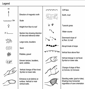
Legend of symbols used.

However, to date no detailed mapping and recording of these caves has been conducted. Evaluating the potential of these caves to contribute to research into the cultural, biological and geological history of the island requires thorough and accurate surveying to provide an initial database of key resources. Hence, the planning of systematic research into the evolution and past use of these caves and their potential for palaeontological investigations requires the availability of good cave maps.
Methodology
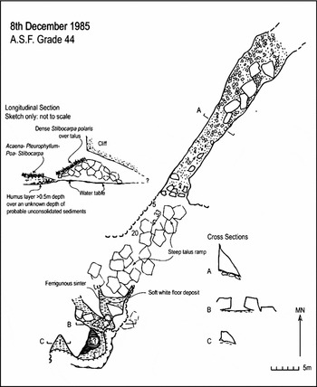
This study results from a brief field reconnaissance of the island's most prominent and accessible caves on the northern part of the island. Caves were selected through field knowledge by one of the authors (Cumpston). In the summer of 1984–1985 a number of the sea caves of Macquarie Island were located and explored by S. Harris and N.J. Mooney. A search for caves in the sea stacks at Mawson Point failed to locate any. The caves were surveyed using hand held Suunto compass and clinometer and horizontal measurements made with a fibreglass tape. Inclinations and bearings were made within ±10° accuracy and resulting maps satisfy at least Australian Speleological Federation (A.S.F.) standard 44. A higher standard is claimed for some of the maps where the surveyors had more confidence that a greater level of detail could be captured. Maps use standard A.S.F. symbols and rules (Anderson Reference Anderson1978). In 1975 G. Copson surveyed caves at Brothers Point. These were surveyed using a 20 m tape. No clinometer was necessary as the caves were horizontally developed. Details about cave structure and deposits were noted in a fieldbook, from which the map appearing here was drawn. A.S.F. 44 was considered the appropriate standard.
Results of the cave survey
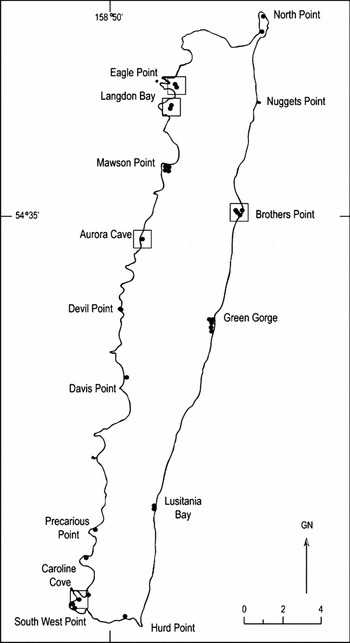
Major cave locations on Macquarie Island are shown in Fig. 2. Maps of the four best known caves are presented, these being; Aurora Cave, Eagle Cave, Cumpston Cave, and Langdon Cliff Cave. The general situation of Cumpston Cave, near Brothers Point is also illustrated. A map and brief description of Hidden Lake is also included here because it occurs in an area that exhibits pseudokarstic attributes including underground drainage through gravels. Elsewhere, other streams flow through tunnels in peat, one example being at Green Gorge where free flow occurs through conduits up to 200 m long. There is occasional flooding to the surface when the capacity of these subsurface conduits is exceeded.
Major cave locations on Macquarie Island. Those considered in this report are indicated.

Aurora Cave
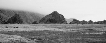
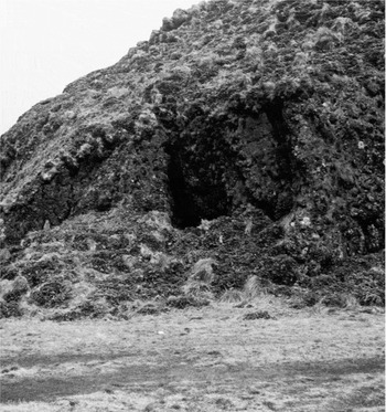
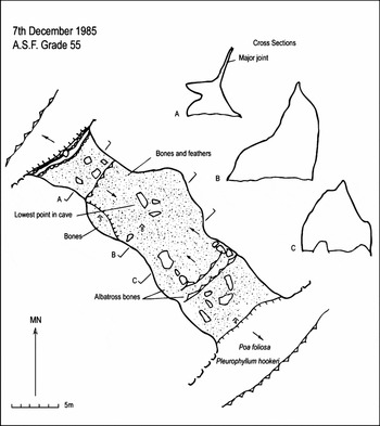
Aurora Cave is a spacious cave just over 27 m long and up to 10 m wide and 8 m high that is prominently located in a large bluff, which can be seen from a considerable distance (Figs. 3, 4). The cave (Fig. 5) has formed along a prominent joint oriented at 305°. The depth of clastic deposits within this cave was not measured but appeared to be considerable. These deposits comprise mostly angular rock fragments resulting from weathering and breakdown of the roofs of the cave. Some material appeared to be rounded like beach cobbles, indicating the deposition of material in the caves by the sea. It is likely that more marine deposit occurs below the roof fall deposits, which have accumulated since the uplift of the island has removed the caves from the direct influence of wave action.
Aurora Cave showing general nature of the coast and stacks.
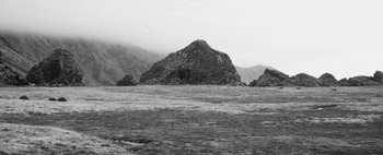
The entrance to Aurora Cave.

Aurora Cave, Macquarie Island.

The cave would have provided protection from rain but as it acts as a wind tunnel, erection of some form of ‘break wind’ would have been necessary to make it more hospitable. Skeletal material of the wandering albatross, Diomedea exulans, and other bones including the lower mandible of a seal pup was noted during the survey of Aurora Cave. It is possible that this is an anthropogenic deposit. In a previous survey of Aurora Cave, the cranial remains of the now extinct Macquarie Island banded rail, Rallus philippensis maquariensis, were found (Vestjens Reference Vestjens1963).
Eagle Cave
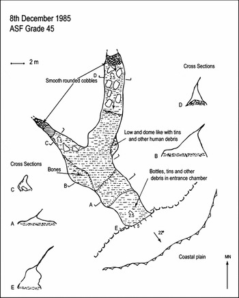
Eagle Cave is a wide but generally low-roofed cave with about 35 m of passage developed in two directions. Joints trending 300° and 10° control the structure of Eagle Cave. A slot ascends from ceiling level for an undetermined distance. Some white sinter occurs on the ceiling (cross section B in the cave map, Fig. 6). The floor of this cave variously comprises mud, gravel, talus blocks and rounded beach cobbles. Although Vestjens (Reference Vestjens1963) also found cranial remains of the Macquarie Island banded rail in Eagle Cave, no remains were found during this survey. Eagle Cave contains deposits of water worn beach cobbles on the floor.
Eagle Cave, Macquarie Island.

On the opposite side of the bluff in which Eagle Cave occurs, there is another small cave formed along the 300° joint direction. Some relics such as a primus stove and other objects were noted by one of us (Copson), presumably remaining from the early Australian National Antarctic Research Expedition (ANARE) years when this cave was apparently used as an emergency shelter, prior to construction of the Bauer Bay hut.
Cumpston Cave
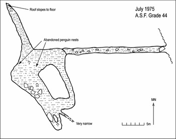
Cumpston Cave is a spacious cave with ~82 m of passage comprising a narrow linear entrance that gives access into a more complex inner chamber (Fig. 7). Its structure appears to be strongly joint controlled. Cumpston Cave contains abundant remains of the dove prion, Pachyptila desolata maquariensis, as well as a vacated penguin nest. Penguins no longer nest in the cave possibly as a result of a large block having fallen from the roof near the mouth of the cave, preventing easy access. Meredith (Reference Meredith1985) suggests that the presence of petrel, skua and penguin bones may be due to the use of the caves by cats. A mummified cat was found in one of the caves at the time it was surveyed in 1975. In 2001 a number of abandoned nests were observed in Cumpston Cave, including evidence of nests of a smaller seabird such as a fairy or fulmar prion, Pachyptila turtur (G. Hedley, personal communication, 28 January 2009).
Cumpston Cave, Macquarie Island.

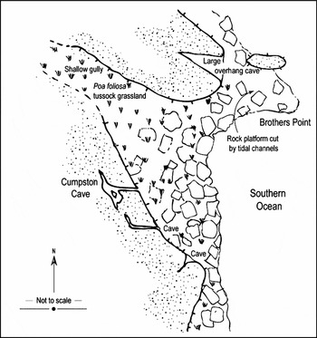
The two caves south of Cumpston Cave (Fig. 8) contain much skeletal material. Interesting discoveries include, in 2001, the mandible of a Macquarie Island Parakeet, Cyanoramphus novaezelandiae erythrotis, in the southernmost of these caves. In 2003 some fossilised bones of a small bird species were recorded (G. Hedley, personal communication, 28 January 2009). The parakeet mandible is now held at the Tasmanian Museum and Art Gallery, Tasmania, Australia (TMAG Registration Number B4678).
Area near Brothers Point, Macquarie Island.

Langdon Cliff Cave
Langdon Cliff Cave (Fig. 9) comprises a linear passage system ~65 m long that has formed along a prominent joint trending ~35–40°. The cave floor falls steeply away from the entrance and appears to be much deeper than the portion surveyed. It is very unstable. The cave appears to go right through the ridge in which it occurs.
Langdon Cliff Cave, Macquarie Island.

Stalactites were observed in Langdon Cliff Cave. These are presumably formed of calcite reprecipitated out of the extrusive igneous country rock. Griffin (Reference Griffin1982: 5.5) records that calcite is ubiquitous in these lavas. The clastic deposits range from mud to large talus blocks. There were also thick humic deposits covered in moss and an unusual soft white floor deposit reminiscent of ‘mondmilch’. No animal remains were observed.
Caroline Cove
At Caroline Cove there is a cave in which partially buried seal skins were found. Fur Seals rarely occurred naturally on the west coast of the island, the population during historical time being mainly confined to the east coast.
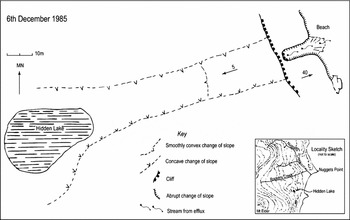
Hidden Lake and its efflux
Hidden Lake occupies a small valley (Fig. 10) about two hundred metres south of Rookery Creek near Nuggetts Point on the east coast. It has subterranean outflow and an efflux approximately 200 m away. The likely explanation for this is that the lake is perched on bedrock in a locality heavily mantled with gravel. The gully along which the lake outflow occurs may have been incised by a surface stream and now contains a considerable depth of gravel and unconsolidated sediments that may have collapsed into the gully from adjacent slopes thereby damming the lake. The stream conduit is under the gravels, most likely at the interface with bedrock.
Hidden Lake and its efflux, Macquarie Island.

The efflux flows through unconsolidated and unstable breccia. The feature is possibly on a bedrock basement. The gravel slopes to the south of the feature are vegetated, rock is in front of the efflux outflow. On the vegetated southern slope, stepped, shallow depressions are seen up the gully lines. These could be due to the slumping of underlying gravels.
Discussion
Adamson and others (Reference Adamson, Selkirk, Price, Ward, Selkirk, Banks and Brown1996) studied evidence from palaeobeaches and sedimentary deposits and used thermoluminescence dating to establish ages for the palaeobeaches. They suggest the island may have only emerged above sea level ~600–700 ka BP and the beach at 100 m altitude is last interglacial ~125 ka BP. We are careful not to over speculate here but further work on the island could establish whether the caves actually formed very fast or whether they may have been initiated at lower sea levels during glacial periods. The deposits in the caves could also well preserve dateable material through which a comparative stratigraphy can be built. Various of the caves contain one or a number of the following features: speleothem development (Langdon Cliff Cave), a diversity of clastic deposits (Aurora Cave, Eagle Cave, Langdon Cliff Cave), algal growths, subfossil deposits (caves in the vicinity of Brothers Point, including Cumpston Cave), cultural relicts (Eagle Cave) and evidence of past faunal habitation (Eagle Cave).
The caves on Macquarie Island have clear links to the history of exploration, for example to Mawson. While many accounts of cave use inform us of the history of the island, the caves on the west coast of Macquarie Island, with relicts of occupation by shipwreck survivors, raise a conundrum. Despite some meagre shelter provided by caves on that coast, it is also the coast that bears the full brunt of the westerly weather. This makes venturing outside any shelter a survival challenge. Because the west coast is most exposed, in the days of sail any ship would have consciously avoided the west coast. Additionally, any survivors occupying these caves would not have been able to observe any nearby ships that may have offered rescue. Evidence of occupation also occurs in at least one cave on the east coast. Whether this represents the relocation of survivors from a western wreck or a different party is difficult to decide.
The historical artefacts observed in some of the Macquarie Island caves highlight the cultural heritage that sub-Antarctic caves may have accrued from past use by ship wrecked sailors, sealers or members of scientific expedition.
For example, on South Georgia, Sutton's party found evidence of human occupation ‘explored the caves on the beach, finding stalactites and a mysterious aged piece of blue cloth’ (Sutton Reference Sutton1958: 173) and again they describe a ‘lovely bay with quiet inland pools at the back and a cave and sea stack on the shore-line. The cave once contained traces of temporary occupation’. These caves parallel those of Macquarie Island in at least two ways: they were probably mechanically excavated by the sea, and they have provided refuge for sailors or castaways. Similarly, the South African possession of Prince Edward Island also has numerous inaccessible sea caves and arches on part of its coast and one is recorded as sheltering castaways (Langenegger and Verwoerl Reference Langenegger, Verwoerd, Van Zinderen Bakker, Winterbottom and Dyer1971).
Formal recognition of the potential value of the Macquarie Island caves, and management protocols to safeguard those values are appropriate. Kiernan and McConnell (Reference Kiernan and McConnell2000) provide a detailed evaluation of the research prospects of the Heard Island caves in fields that include geomorphology, hydrology, cave climates, pedology, microbiology, botany, zoology and archaeology. They conclude with recommendations for approaching cave management on Heard Island. The caves on Macquarie Island are morphogenetically distinct from lava caves but similar potential research values to the Heard Island caves may indicate that management prescriptions need to also be formulated for Macquarie Island cave features.
Conclusions
Four sea caves have been mapped on Macquarie Island. Together the caves offer scope for archaeological, palaeoenvironmental and geomorphological research. There is a variety of clastic sediment deposits, some speleothem features, and some organic deposits. Previously, the caves have provided valuable information regarding early occupation of the island. It is recommended that the deposits are left undisturbed until a comprehensive survey is planned and conducted. This is consistent with the prescription of the Macquarie Island Management Plan (Parks and Wildlife Service 2006). These maps will provide assistance in future research planning.
Acknowledgments
Dr Jim Peterson, Monash University provided valuable comments on the manuscript and the suggestions of the two anonymous referees were very helpful. Mr Graeme Watt of the Australian Antarctic Division Library in Hobart very kindly assisted in locating some publications.