

The Poste is a civilizing agent, a carrier of enlightenment, a facilitator of commerce, industry, and science that strengthens familial bonds of all classes, thus serving as the best safeguard against demoralization.
(Léon Rian, Rapport au Ministre des Finances, 1877)
States make nations; nations don’t make states.
(Eric Hobsbawm, Nations and Nationalism since 1870, 1990)
In nineteenth-century Europe, central states took up a new project: nation building. Prime examples were the unifications of Italy in 1861 and Germany in 1871. Once unified, the new states turned next to forging national identities and loyalties, aiming, for example, to assimilate Bavarians into Greater Germany. In this context, Britain and France evinced earlier varieties of the process. Already unified and possessed of national identities to varying degrees, both states instituted new policies to better incorporate their rural populations. A major tool in this effort was the postal service. Its expansion and reorganization, as viewed by administrators, would lead to greater political, cultural, and social integration. It would produce greater national cohesion. When people in remote villages and isolated farms could count on receiving daily mail, they were apt to feel a stronger tie to the national community. For the state, postal communications would yield increased knowledge of the population it governed and would therefore facilitate mobilizing political support and military force.
Putting these ideas to work is an interesting story, told here in three parts. The first concerns government policy. The second concerns getting the mail to and from home doors in town and country by postmen who delivered the mail on foot, walking designated routes. The third part examines the link between mail and rail. The interworking of policy, postmen, and railways proved a transformative combination. The following tells the story by way of a comparative, spatial history.
This approach yields a substantial contribution to the existing historical literatures by bringing historical geography to the fore, by blending methods of GIS with historical sources, and by using comparison to illuminate similarities and differences. At present, the history of postal service in nineteenth-century France and Great Britain is composed mainly of institutional histories that deal with one country only. Numerous studies describe post-office development in terms of postal organization; governing policies and financial management; traveling post offices in rail cars; and a growing list of services regarding letters, post cards, newspapers, books and parcels, money orders, and banking, telegraphic, and telephone services. For Britain, histories of the modern post office typically begin with Roland Hill’s introduction of the Penny Post in 1840, an unprecedented policy that provided a uniform and inexpensive tariff for letters sent from any part of England and Wales. Institutional accounts then move on to describe the continued efforts at expansion under Hill’s successors as Post Master General (Campbell-Smith Reference Campbell-Smith2012; Daunton Reference Daunton2015; Johnson Reference Johnson1995; Lewins Reference Lewins1865).
For France, the historical literature is surprisingly limited. The sole account of the French post office in the nineteenth century is a slim volume published in 1946 in the popularizing series Que-sais-je? (Vaillé). Recently, Mauriel Roux and others are working to revitalize this much neglected field (Bertho-Lavenir Reference Bertho-Lavenir1997; Richez Reference Richez2007b; Roux Reference Roux1998; Roux et al. Reference Roux, Sébatien and Eugene2018; Verdier and Bretagnolle Reference Verdier and Anne2005; Verdier and Chalonge Reference Verdier and Ludovic2018). Somewhat surprisingly, the subject of expanding postal service is little discussed in seminal studies of rural France in the nineteenth century. In Peasants into Frenchmen: The Modernization of Rural France, 1870–1914, Eugen Weber (1976) points to schools, railways, and roads as major agents of national unity and rural change, while treating expanding postal service more in passing to conclude its affects were more or less marginal in remote areas. For Roger Price (1983), the communication networks he describes in his Modernization of Rural France were those formed by new roads and railways. Postal communication is ignored. Alain Corban (1975: 787) briefly notes that correspondence and coordination by mail took place among migrant workers in the Limousin but in other studies of associations and syndicates, that possibility remains an unexplored question (Baker 2004; Margandant 1979).
Still more limited in nature and number are studies of postal service that engage historical geography. Of the few available, Nigel Thrift’s book chapter on transport and communication in England and Wales from the 1730 to 1914 offers a substantial and insightful account of interrelated change. His opening point needs to be quoted, for it offers an excellent point of departure for this article.
transport and communication cannot be split apart. Each relies upon the other in all manner of ways: for example, the development of newspapers is tied up with the history of the Post Office, the railways and the telegraph, the development of the Post Office is tied up with the history of the railways and the telegraph, the development of the railways would have been hindered without the invention of telegraphy and the telegraph’s development would have been slower without the railways. (Thrift Reference Thrift, Butlin and Baker1990: 423)
The Penny Post, he notes, was a democratic instrument intended to equalize the cost of postal access across all parts of England and Wales. In practice, however, the effect of uniform postage was spatially uneven. Owing to the slow growth of provincial post offices and the limited number of mail carriers, small towns and rural areas remained disadvantaged (ibid.: 468–69). If, as we shall see, this claim is in need of revision, his broader conclusions are worth taking on board. The expansion of postal communications, he argues, led to a gradual melding of English and Welsh society and to greater degrees of political, social, economic, and cultural cohesion (ibid.: 477–78).
In France, Cécile Dauphin, Pierette Lebrun-Pezerat, and Danièle Poublan published in 1991 a pioneering application of GIS methods with historical data. A post office enquiry of 1847 generated a vast collection of information concerning postal operations during a period of 15 days. Each of 36,000 communes was charged to report the number of letters received and sent, the number of newspapers received, the distance to the closest post office, and the proportions of the local population in two categories: clustered and dispersed. The analysis by Dauphin et al. demonstrates clearly that the state’s institution of a rural postal service in 1830 produced desired results in rural areas—and before the incorporation of railways into the system (Dauphin et al. Reference Dauphin, Lebrun-Pezerat and Poublan1991).
Anne Brettagnolle and Nicolas Verdier have also used GIS with historical sources to study the postal system that was based on horse-drawn coaches and roadways. Thanks to road improvements and postal reorganizations, this system performed increasingly well in the eighteenth century; and with modifications for greater efficiency, it remained in use into the 1870s when the last coach was retired (Roux et al. Reference Roux, Sébatien and Eugene2018: 153; Verdier Reference Verdier2007; Verdier and Bretagnolle Reference Verdier and Anne2005; Verdier and Chalonge Reference Verdier and Ludovic2018).
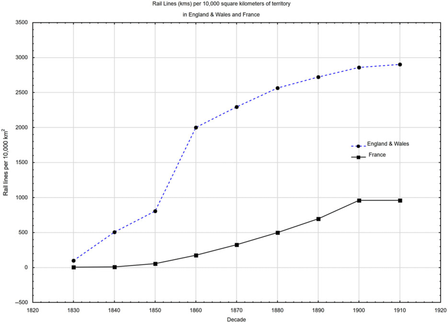
Likewise in Britain, road improvements made the horse-drawn carriage of mail quicker and more efficient. In 1836, England 54 four-horse coaches and 49 two-horse coaches were in use, carrying the bulk of some 75 million letters and 32 million newspapers (Gregory Reference Gregory1987: 137; Lewins Reference Lewins1865: 208). In both Britain and France, however, the circulation of mail in the countryside remained irregular and sparse until the postal reorganizations of the second third of the century took effect (see figure 1).
The growth of rail service in Great Britain and France, 1830–1910.

Legwork: The Transformation of the French Poste
In 1830, a decade before British postal expansion began, the French state launched what it called “lettres à domicile,” the home delivery of letters to all parts of the country, including every commune, hamlet, and isolated locality. To carry this out, a new program called the Service Rural was established. This was far-reaching reform. Up to then, mail distribution was a local responsibility that was hampered by geographic inefficiency. A commune (similar to the English civil parish) was responsible for collecting letters for residents, not at the closest post office, but at a main office in the nearest large city. In rural areas, travel time and costs were considerable. The new program introduced a rational restructuring; each of 63,000 localities was identified and attached to the closest post office in existence, thus improving the flow and speed of home deliveries (Direction générale de la poste 1837: vii). The weight of the whole project depended upon the legwork of facteurs rurals (rural postmen) who every day walked some 25 kilometers to deliver letters and to pick up outgoing correspondence (Richez Reference Richez2007a: 38). As the volume of mail grew so did the number of facteurs. Whereas the original goal was to provide mail distribution every other day, a policy of 1832 called for a distribution every day where possible. Accordingly, the number of rural postmen increased to 7,900 in 1836, to 9,000 in 1849, to 19,010 in 1900, and to 23,229 in 1914 (ibid.: 31; Ministère des postes 1900: 42).
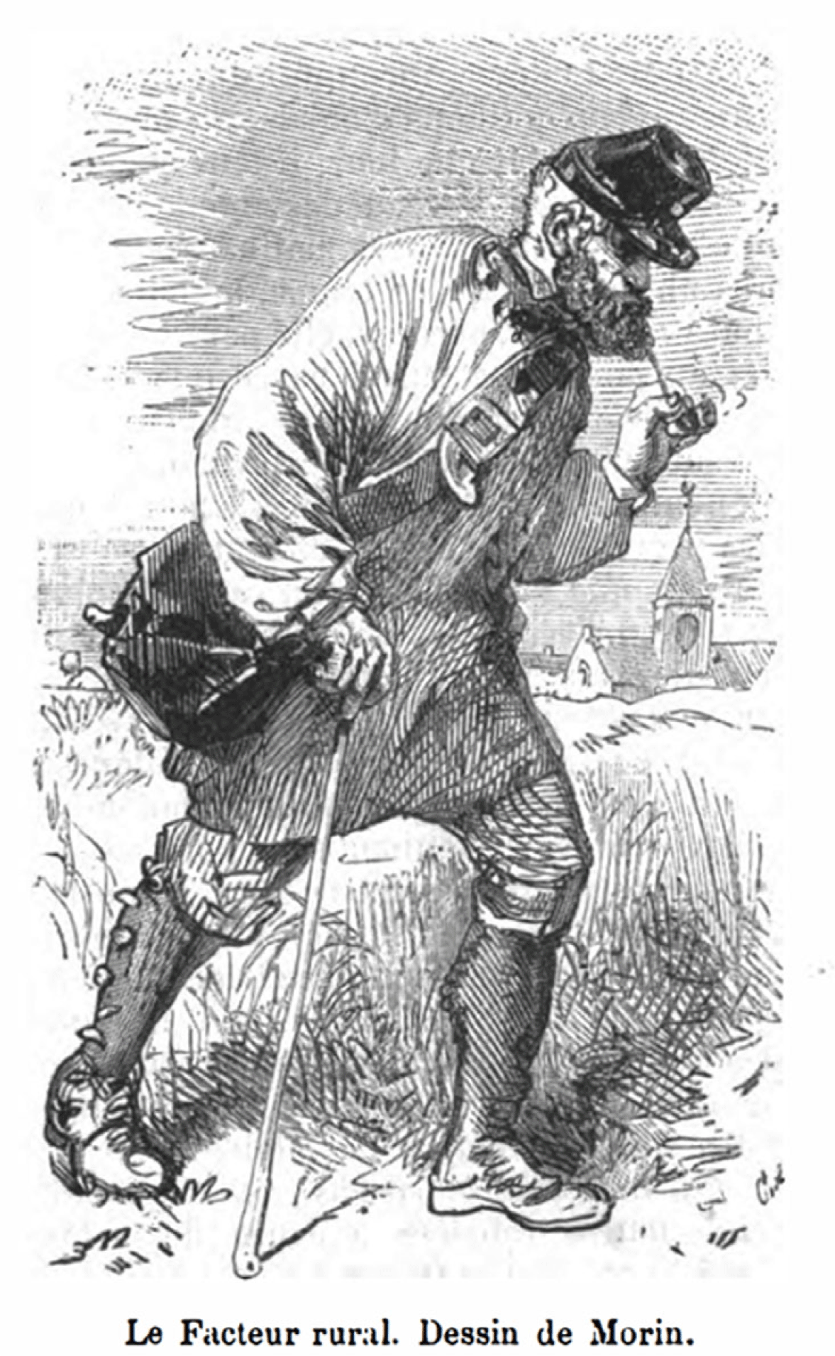
The regular appearance of the rural facteur brought the state to the house door every day—a face-to-face, meaningful encounter. Dressed in a blue tunic with metal buttons inscribed with “Services des Postes—Facteur rural,” a blue felt hat, and a small red cape, his visit, in the eyes of clients, suggested equality and the benefit of being served like all others (Bertho-Lavenir Reference Bertho-Lavenir1997: 40; Oger Reference Oger2000; Pannetier Reference Pannetier1991; Quantin Reference Quantin2004: 128; Richez Reference Richez2007a: 40). Newspaper articles praised his service, and the government followed suit. In the postal administration’s monthly periodical, Le Journal des Postes (also known as Bulletin mensuel de l'Administration des Postes), an article in 1868 portrayed the rural postman as the veritable locomotive of the postal service, who by the age of 60 had carried mail more than 438,000 kilometers (see Image 1). Bringing letters, stamps, postal savings books, and newspapers to the door, the rural postman, writes historian Sébastien Richez, was “an agent of national identity, of reading and writing, and for long the sole bearer of information in the countryside” (Richez Reference Richez2007a: 31).
In other issues of Le Journal the facture was hailed as the embodiment of loyalty, courage, and integrity. His regular acts of admirable service were described in nearly every issue.
1869. Mr. Guieu, rural postman a Seyne-les-Alpes—saved from imminent death a little girl four years of age, whose clothing was in flames, and took her to her parents’ house where he bandaged her despite the serious burns on his hands. (Direction générale de la poste, Bulletin mensuel de l’Administration des Postes. Bulletin mensuel de l’Administration des postes 1869: 348)
1878. Mr. Laroque, rural postman at Lourdes, found in the road a wallet containing 800 francs that he returned to his supervisor and subsequently restored to the owner. (ibid. Bulletin mensuel de l’Administration des postes 1878: 348)
1880. Mr. Conneau, rural postman at Chabris, dove into a very deep part of the [river] Cher to pull out a lad of 14 years of age, who without [Conneau’s help] would surely have drowned. (ibid. Bulletin mensuel des postes et télégraphes. PTT 1880: 245)
In his report to the Minister of Finance in 1865, the Director of the Poste, Edouard Vandal, was quick to praise the Service Rural in his plea for an expanded budget—likely stretching the truth in places to buttress his request. “Your Excellency,” he began, should know that the Service is a great success. For two years under my direction, “each commune has been endowed with daily mail service. Unique among all the nations of Europe, France assures that every inhabitant, however distant he may be from a post office, every day receives his correspondence and his newspaper.” This exceptional and “eminently democratic” service, Vandal continued, was costly. The wages of the 17,000 rural postmen come to more than 8 million francs per year, and despite increased wages, “the distresses of these agents arouse universal sympathy.” Their usual day sees them cover 26 kilometers, and their average salary is 1.40 francs per day. The additional sums allocated for their wages in 1866 will reflect well on the government by showing sympathy for “a class of functionaries whose services are universally appreciated” (Vandal Reference Vandal1865: 16–17).
Engaging the Railways
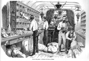
Vandal’s report also heralded a new component of La Poste, rail transport. The entire postal system, he wrote, relied on the bureaux ambulants, rail-borne traveling post offices that constituted “the main arteries of postal circulation” (ibid.: 7). Every day nine-tenths of some 1.8 million pieces of mail were so conveyed. Organized in 1854, the system of “wagons-Poste” required the private rail companies of France to convey the mails on main rail lines (see Image 2). Contracts known as cahier de charges set forth the companies’ obligations, which state administers were empowered to renegotiated from time to time.Footnote 1 In 1854 the contracts specified nine existing rail routes for postal conveyance and extended the obligation to lines opened in the future. At existing and future stations, companies were to provide office space for postal bureaus. At stations on secondary lines, they were to install letter boxes. Carriage of the mail was to be free of charge except when special requests called for additional trains (Anonymous 1875: 131–34). The key steps of mail distribution were sorting, transfer, and delivery. During the railway voyage employees in specially designed cars sorted the mail for offloading at the appropriate rail station. From a station, agents transferred the newly arrived mail to a main post office or to a branch office as needed, eventually to arrive in the hands of postmen who made the deliveries. As the rail network expanded, postal administrators were able to extend service to new localities with proximate rail transport. Thereby, directors thought, the gratitude of favored localities would grow.
In reality several factors determined the creation of a new post office. One was financial: the state expected the postal service not only to pay its own bills but to make a profit for the national treasury. A second factor was political: the prevailing view of “equity” among the governing elite and the conviction to put the idea into practice. Up to the 1870s, the principle of equitable distribution, set down in the law of 1829, was far from being realized. The situation changed under the Third Republic.
After the defeat by Prussia in 1871, reforming the Poste became a nationalizing project. The mission to restore national loyalties was both intensified and hampered by reparation payments to the German Empire. Reluctantly, postage fees were raised. The basic rate for letters increased from 10 to 15 centimes. Amid the state’s financial woes, the Director of the Poste, Léon Rian, pressed ahead. Invoking the national project, he asked the Minister of Finance for additional funds. The functioning of postal service, he emphasized, was like a “sacred calling,” for “it touches the most intimate interests of the population.” The faithful and rapid transmission of correspondences was “a sacred trust” that requires “loyal personnel of integrity, energy, and experience” (Rian Reference Rian1877: 8). The Poste, he continued, was a “civilizing agent, a carrier of enlightenment, a facilitator of commerce, industry, and science that strengthens familial bonds of all classes, thus serving as the best safeguard against demoralization” (ibid.: 9). As it happened, he prevailed. Under his direction, more than 3,000 bureaus were opened in new localities.
In 1900, Director Alexandre Millerand, cited weakened national prestige to justify still further expansion. France “is far from occupying an honorable rank among the great nations in terms of the number postal establishments” (Ministère des postes 1900: 16). In 1897, Germany had 34,500 establishments; the United States, 71,000; and Great Britain, 21,200. Sadly, France had fewer than half [9, 458] the number of establishments existing in Britain (ibid.: 166). Requests for new post offices, he continued, increase every day, as do the complaints when requests are refused. Of the 1,200 received to date, 1,000 of them were solidly based claims and were rightfully granted to communes more distant from a central office.
For Millerand, the traveling posts was one of the bright spots. Adding 49 new routes from Calais to Lille, Lyon to Marseille, and elsewhere, all from provincial city to provincial city, extended the arteries of circulation beyond those centered on Paris. One hundred postal trains, he added, were in daily operation, and the performance of the service was excellent. All told, the pairing of postal services and the railway yielded an annual movement across the network of 54,751,000 kilometers (ibid.: 30). That flow, he added, could be improved if the critically overburdened system acquired new rolling stock and more personnel to relieve those working 12- to 15-hour days.
Another bright spot was the Rural Service. It was a hallmark of national pride. “Everyone knows that there is no other country in which rural postal service is more extensive than in France.” No other country’s service “encompasses all parts of the territory, without neglecting, as [happens] in England, hamlets … or a single domicile that is isolated or nearly inaccessible.” Unlike England and Germany, there are deliveries on Sundays and holidays, [and] deliveries that everyday reach all places in the country, in contrast to England “where more than 400 villages see a postman only 1 to 5 times per week.” Our postmen, now 19,000 strong, cross 513,000 kilometers daily, a distance equal to 12 times a trip around the world. “The French Rural Service is the envy of European states” (ibid.: 41).
Mail in France: Spatial Analysis
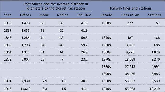
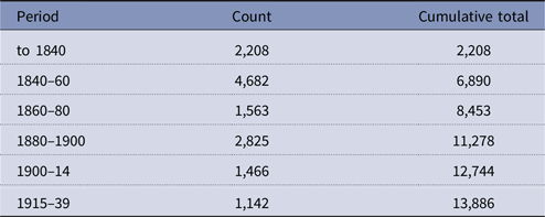
As the rail network extended across the country, so the railway arteries of postal service reached into hitherto unserved areas, and the volume of mail conveyed by wagons-poste continued to grow. In 1900, 70 trains each day conveyed the mails using the wagons, 35 leaving Paris for provincial centers and 35 moving from those centers to Paris (ibid.: 40). From the 1870s, many new post offices were opened in or near rail stations, as indicated in table 1 and figure 2, showing the related evolution of postal and railway capacities. As postal directors desired, major increases in the postal and rail networks clearly took place in the first decades of the Third Republic (1871–1941).
Post offices and rail lines and stations in France, 1830–1913

Sources: Post office information from Nicolas Verdier; railway lines and stations from Thomas Thevenin and Robert Schwartz, Historical GIS of railways and stations in France, 1820–1930 (a georeferenced database).
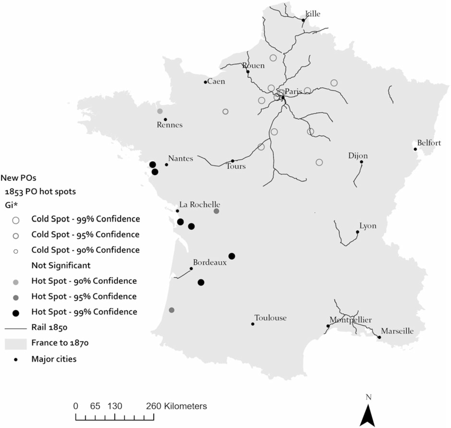
Cluster analysis of newly established post offices in 1853.

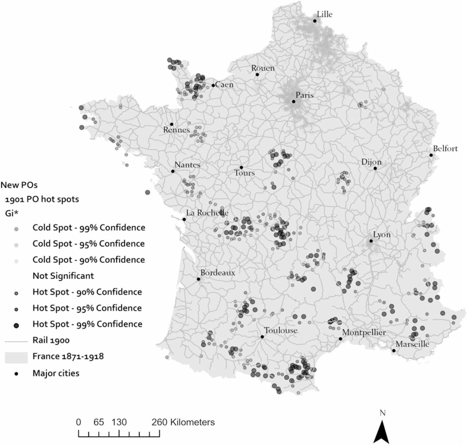
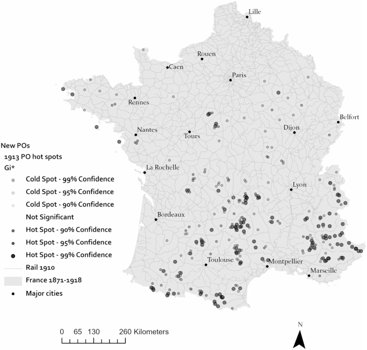
The increasing dependence of the Poste on railways can best be seen as a geographical problem by mapping the proximity of new post offices to the nearest rail station in their respective areas. Chronologically, a proper point to begin is the decade of the 1850s when the partnership of mail and rail was formally established. Here, we turn to spatial statistics to analyze the evolving pattern. In a given study area, the Getis-Ord Gi* statistic identifies spatial clusters of extreme values in a geographic distribution of an attribute. It then groups them into two categories of statistical significance: cold spots and hot spots. Clusters that are statistically insignificant comprise a group of values that are less extreme than those in the hot and cold clusters. Levels of statistical confidence refer to the probability that an extreme value would not occur merely by chance. In studies of the spatial distribution of cancer, hot spots indicate a cluster of places with exceptionally high rates of the disease; cold spots, places with lower-than-expected rates. In the case at hand, the distance from a new post office to the nearest train station is the attribute of interest. Hot spots identify the offices that are outliers in the distribution because they are significantly farther from the nearest train station than all others in the distribution. Cold spots identify the inverse pattern: offices much closer to stations than all others. Comparing the patterns of extreme values over time (1853, 1873, 1901, and 1913) is a good way to gauge the relative accessibility of new post offices to rail transit in those years. A decline in the number and location of hot spot clusters over the years will indicate degrees of improved accessibility and equity in postal service. An increase in hot spot clusters will indicate a diminution of equitable service in the given year or period.
Figure 2 displays the results for 1853. Coming in an early phase of railway development, the hot spot outliers (shades from dark gray to black) were extremely far from the closest station (not shown) in relation to the other values. This map will serve as the baseline from which to gauge changes in hot spot clusters in following decades. For clarity, let us refer to hot-spot instances as “offices with distant links” to rail transit; cool spots, as “offices with close links.”
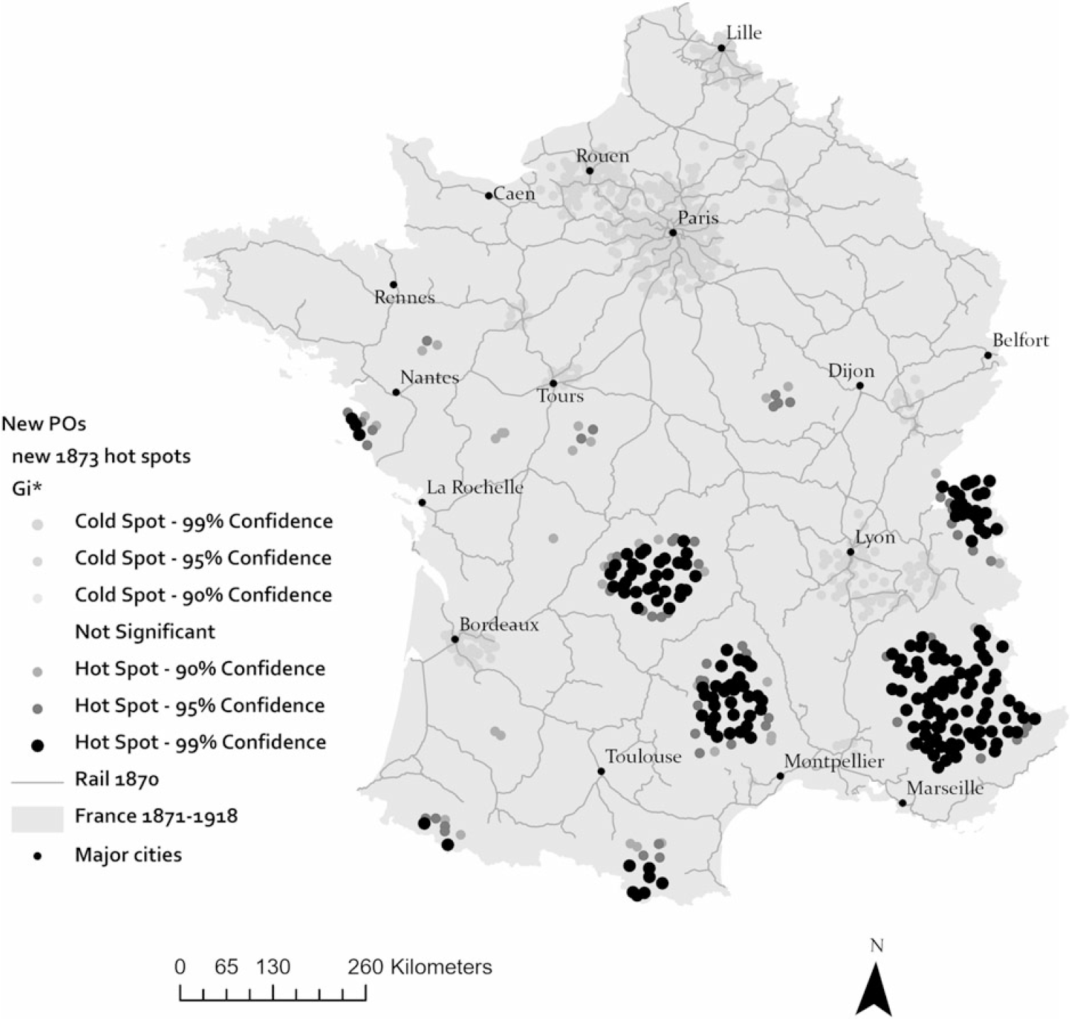
Two decades later in 1873, about 4,000 post offices had been newly created, nearly a fourfold increase since 1853 (see table 1). By the 1870s the railway network was also expanding rapidly, reaching much of the country, except the rugged terrain of mountainous regions in the south and the Alpine southeast. As one might suspect, the pattern displayed figure 3 shows the concentration of new post offices very close to rail stations in Paris and its hinterlands (closely linked bureaus). Conversely, clusters of distant-link bureaus far from stations were, not surprisingly, predominant where railways had not reached in the southern uplands and mountainous areas.
Cluster analysis of newly established post offices in 1873.

In 1901, the transformation of the Poste in the Age of Rail was nearing completion. The distance of new post offices to rail transport, although still geographically uneven, was much diminished throughout the country (see figure 4 and table 1). Moreover, a few new bureaus were opened in mountainous areas. Figure 4 displays the pattern for the year 1901. Dense concentrations of proximate bureaus expanded in the Paris region and spread in the industrial northeast (Lille and Nancy) and in the urban center of Lyon. At the same time, numerous distant-link outliers were scattered in regions lying below a line from Caen to Lyon. The interpretation of this deserves attention.
Cluster analysis of newly established post offices in 1901.

As the railways expanded and additional stations opened, the average distance separating a post office and the nearest station declined significantly; or, in terms of accessibility, average accessibility of post offices to rail transport increased. The average distance to a station in 1901 was 2.9 kilometers, as compared to 12 in 1873. This was the difference between an easy walk and a half-day’s trek. The shrinkage of postal space over the years entailed a change in the meaning of “close” and “distant.” What was “close” in 1873 when the average distance was 12 kilometers became “distant” in 1901 when the average had declined to 3 kilometers. Returning to figure 4, the distribution of distant-link offices can be called the “geography of slower mail.” All post offices would receive and dispatch mail but it would take more time for offices at greater distance from mail trains to get the job done. The beneficiaries of the geography of faster mail were, of course, in the concentrations of closely linked bureaus and stations in Paris, the northeast, and Lyon.
Between 1901 and 1913, the creation of some 3,600 additional bureaus attested to the government’s concern to catch up with other European powers and advance the nation’s international standing. In France the effort proved a significant achievement. Of some 2,793 cantons for which information is available, only 164 lacked its own post office. True, the geography of slower mail persisted in localities where new offices were opened, in the uplands and mountainous regions of the south, and in scattered places around Dijon and in western Brittany. But that was only a part of the story. Indeed, the most interesting and consequential result was the development of a postal geography of equity. Long a national goal, greater equity in the placement of post offices arose from political will in policy and from the partnership of mail and rail (see figure 5).
Cluster analysis of newly established post offices in 1913.

Mail and Rail in Great Britain: Policy and Practice
In 1838, at the prompting of the Board of Trade, Parliament passed a law providing for the carriage of mail by railways, joining at the hip the post office and the first railway system in the world. According to the board, the post office “was obliged to have recourse to railways, or suspend operation [because] the iron roads had already put a stop to most of the stage-coach traffic on principal roads” (Lewins Reference Lewins1865: 160). Two years later in 1840 the Parliament authorized the Post Master General, Rowland Hill, to institute a low, uniform rate for mail postage throughout the country. Known as the Penny Post, a letter posted for 1 penny (pence) could be carried from London’s Euston Station to Preston, Lancashire in less than 11 hours by train compared to 24 hours by the fastest mail coach (Simmons Reference Simmons1991: 222). In 1846 the last London mail coach called it quits (Thrift Reference Thrift, Butlin and Baker1990: 468). In the first five years of railway conveyance, the number of letters dispatched increased threefold, from 75 million in 1838–39 to 219 million in 1842–43. Daily mails from London on the major railway lines gave principal towns in the country two mails from the capital each day (Lewins Reference Lewins1865: 208).
To extend postal service beyond the principal towns, the Lords of the Treasury issued a directive in August 1841 (British Parliamentary Papers 1841). The expressed aim was the more equitable distribution of mail service than then existed. When considering the establishment of new post offices, areas where service was poor or did not yet exist were to be given priority over areas where a post office and adequate service already exited. Interestingly, the Lords rejected a policy in force in France at the time that was based solely on the ability to bear the cost of service. Setting cost aside, the Lords preferred treating postal service as a public utility. A policy of equity was thus set forth at the beginning of the expansion.
The number of post offices in every district should be in proportion to the amount of population and the extent of the territory served combined: that is to say, that they should be nearer to one another where the population is dense, but more numerous, as compared with the inhabitants, where the population is scattered (British Parliamentary Papers [hereafter: BPP] 1843).
The districts in question were the Registration Districts established by the Registrar General for recoding births, deaths, and disease. Every district, of which there were 630 in England and Wales, was to have at least one post office.Footnote 2
The Post Master General managed the expansion. His first official report of 1854 was at pains to note that the increase in rural posts was gathering pace, with new or improved service introduced in 245 towns and villages (BPP 1855: 20–21). To serve areas where the volume of correspondence was insufficient to warrant a new office, mail carriers were put to the task.Footnote 3 A new corps of Rural Messengers was created, composed of carriers “who in a walk, including generally small villages, afford the inhabitants frequent and regular opportunities of sending and receiving letters” (ibid.: 20).
Gradually and unevenly, postal service to rural and remote areas advanced. At the turn of the century (1898) the Post Master General underscored the progress: “One of the most important features of the postal history of the year under review is the extension of the rural deliveries” (Post Office 1898: 7). Moreover, the government was working to complete the plan begun in 1840 “to give a regular delivery of letters to every house in the kingdom” (ibid.: 8). Universal delivery, he admitted, would require more time, and remote homes might not get daily delivery soon, but the goal, he emphasized, was now within sight.
The figures in table 2 attest to the confidence expressed in his statement. The tallies of new post offices and periodic totals show that the greatest expansion took place in the first two decades of the project. A second expansion in the decades of 1880–1900 underpinned the claim in 1898 that universal delivery was on the near horizon. In 1914, the Post Master General reported that the goal had been reached (Post Office 1914: 24).
The growth in the number of new post offices in England and Wales

Source: Ken Smith and Nick Bridgwater, annotated lists of UK post offices, https://sites.google.com/site/ukpostofficesbycounty/home.
Note: Figures include post offices opened during the 1914–19 wartime period: 21 post offices in 1914 designated “camps”; 24 post offices camps in 1915–19. Post offices opened at unknown dates are omitted.
Mail and Rail: Spatial Analysis of Britain
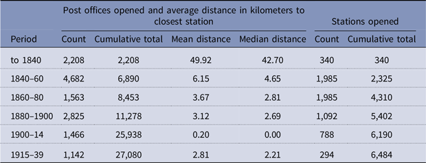
The marriage between the post office and the private railway companies in 1838 meant that postal expansion and rail expansion went hand in hand. This relationship stands out in table 3 showing how the proximity of new offices to the nearest station increased substantially from 1840 to 1914. Where and when were these offices established? Here, temporal geography yields the answer. In addition, spatial statistical analysis leads to an alternative conclusion to Thrift’s claim that expansion was slow and uneven and that small towns and rural areas remained disadvantaged (Thrift Reference Thrift, Butlin and Baker1990: 468). Although the growth of the postal network was gradual and uneven, growth over the years diminished geographic inequities and rural areas benefitted accordingly. The key task is to study the evolving geographic relationship between the location of newly created post offices and their proximity to stations in the growing railway network.
Increasing proximity of new post offices to rail stations, England and Wales 1840–1939

Sources: Ken Smith and Nick Bridgwater, annotated lists of UK post offices and the Historical GIS of British Railways, a georeferenced database constructed under the direction of Jordi-Martí Henneberg.
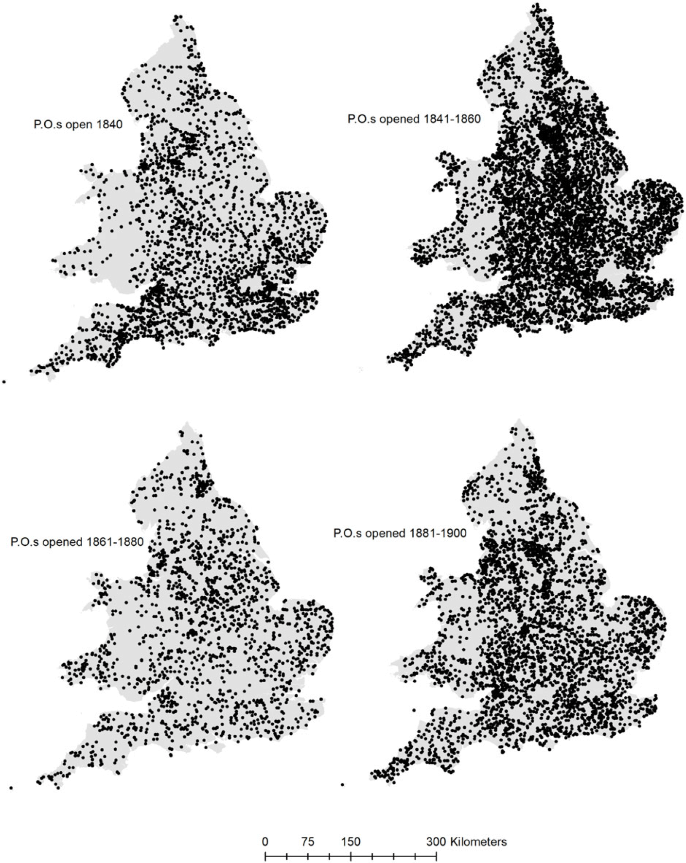
Figure 6 maps the spatial distribution of new post offices in five periods—up to 1840, 1841–60, 1861–80, 1881–1900, 1901–14. The first period of expansion from 1841 to 1860 proved the most geographically extensive, followed by that from 1881 to 1900. After 1840, the rail network of lines and stations grew substantially also. By 1900 rail lines totaled 41,000 kilometers, double the total in 1860, and more than a third larger than the total in 1870 (maps of the railways are omitted to meet the constraints of article length).
The geographic expansion of post offices from 1840 to 1900.

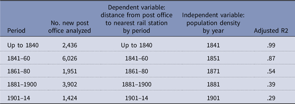
For the pre-railway period up to 1840, the number and location of post offices were evidently determined largely by population density and proximity to ports and major cities. Thereafter, the policy of favoring sparsely populated districts for new bureaus took hold, while the factor of high population density steadily weakened as did the favoring of large towns (see table 4). As in France, it seems a trend toward greater geographical equity was developing in Britain. To test this hunch, the same method used for France—Getis–Ord cluster analysis—works well.
Decline of population density as a determinant of post office locations

Source: Data used in figure 2 and population densities from the Historical GIS of Great Britain, Ian Gregory and Humphrey Southall. Geographically weighted regression done in ArcMap.
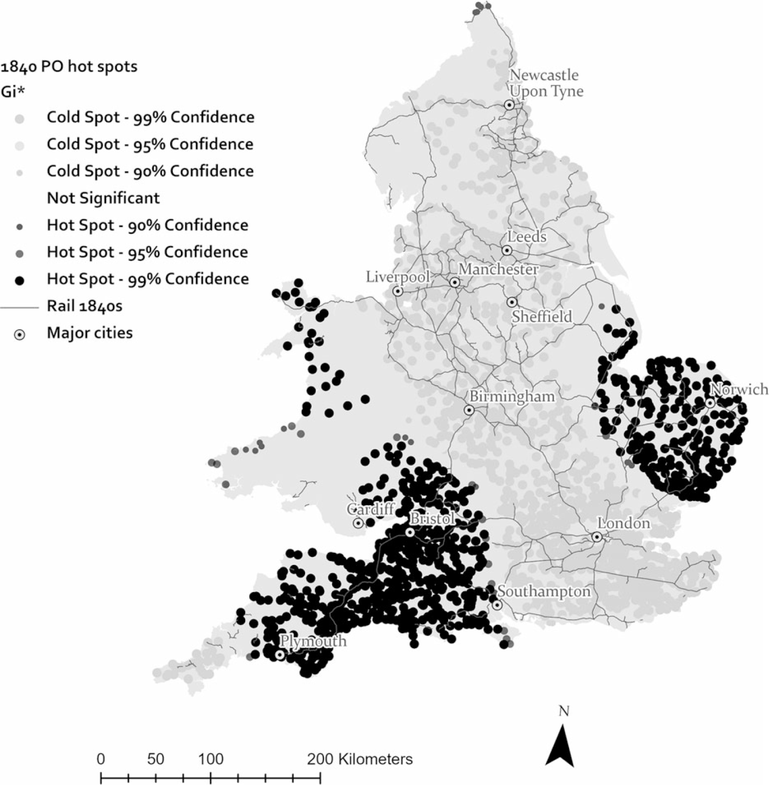
Figure 7 maps the distribution of the distance from existing post offices to the nearest railway station in 1840. The map depicts the distribution of two types of linkage: close links (cold spots) that characterize offices very near stations; distant links (hot spots), office very far from stations. Close link clusters populate the corridor comprising the industrializing North and Midlands, greater London, and the southern counties of Hampshire, Surrey, and Kent. Offices with distant links were clustered in East Anglia, the Southwest, and Wales. Equitable coverage of mail by rail had yet to make any headway in these peripheral regions of the country.
Cluster analysis of post offices open in 1840 and their distances to the nearest railway station.

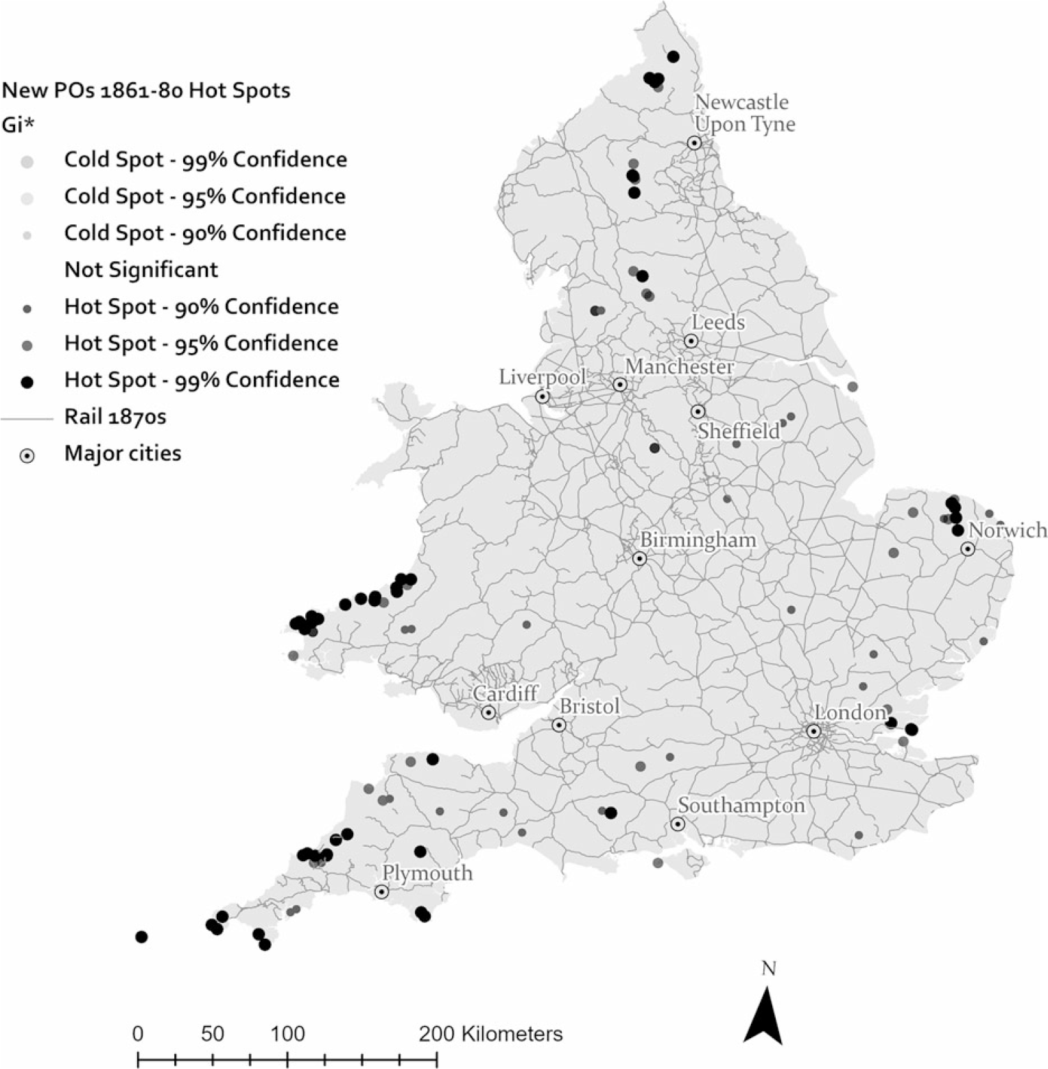
Forty years later the geography of mail by rail had changed markedly. Figures 8 and 9 display the evolution toward equity in placing new offices, showing the diminished presence of distant-link outliers in small clusters of districts in Wales, Norfolk (East Anglia), the West and Southwest, and in agrarian areas of the far North. Compared to 1840, clusters of close-linked offices were tightly concentrated in and around London, in the manufacturing districts in the Midlands and the North, and in the coal fields of Newcastle and southern Wales. This pattern for the period 1861–80 (figure 9) represents a midpoint in the evolution of postal access.
Cluster analysis of post offices opened from 1841 to 1860 and their distances to the nearest railway station.

Cluster analysis of post offices opened from 1861 to 1880 and their distances to the nearest railway station.

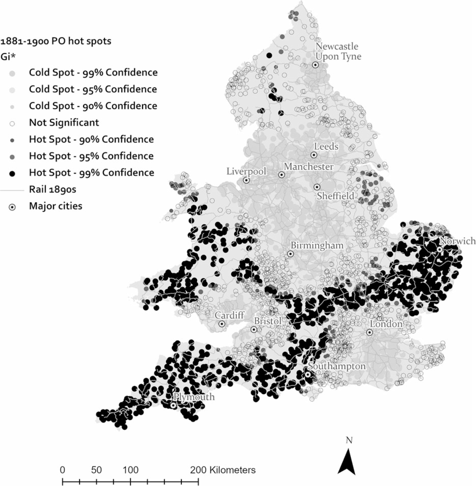
From the 1880s to eve of the Great War, the geography of developing equity in the postal network neared completion. During the first two decades (1881–1900) the Post Master General had large numbers (2,825) of new offices opened in small towns and rural districts in areas previously neglected: in East Anglia, in a band of communities between Birmingham and London, in the Southwest, and in Wales (see table 2 and figure 10). This reflected the postal administration’s effort to carry out the expressed priority of extending service to underserved districts. A comparison of the patterns in figures 9 and 10 makes that clear. Putting policy into practice at such a large scale led to an interesting development. The large increase in new offices greatly outpaced the growth rail stations. With the average distance to new stations being small (3.1 kilometers), many new offices were located beyond the average proximity and are indicated on the map as outliers with distant links (see figure 10 and the distribution of insignificant office locations).
Cluster analysis of post offices opened from 1881 to 1900 and their distances to the nearest railway station.

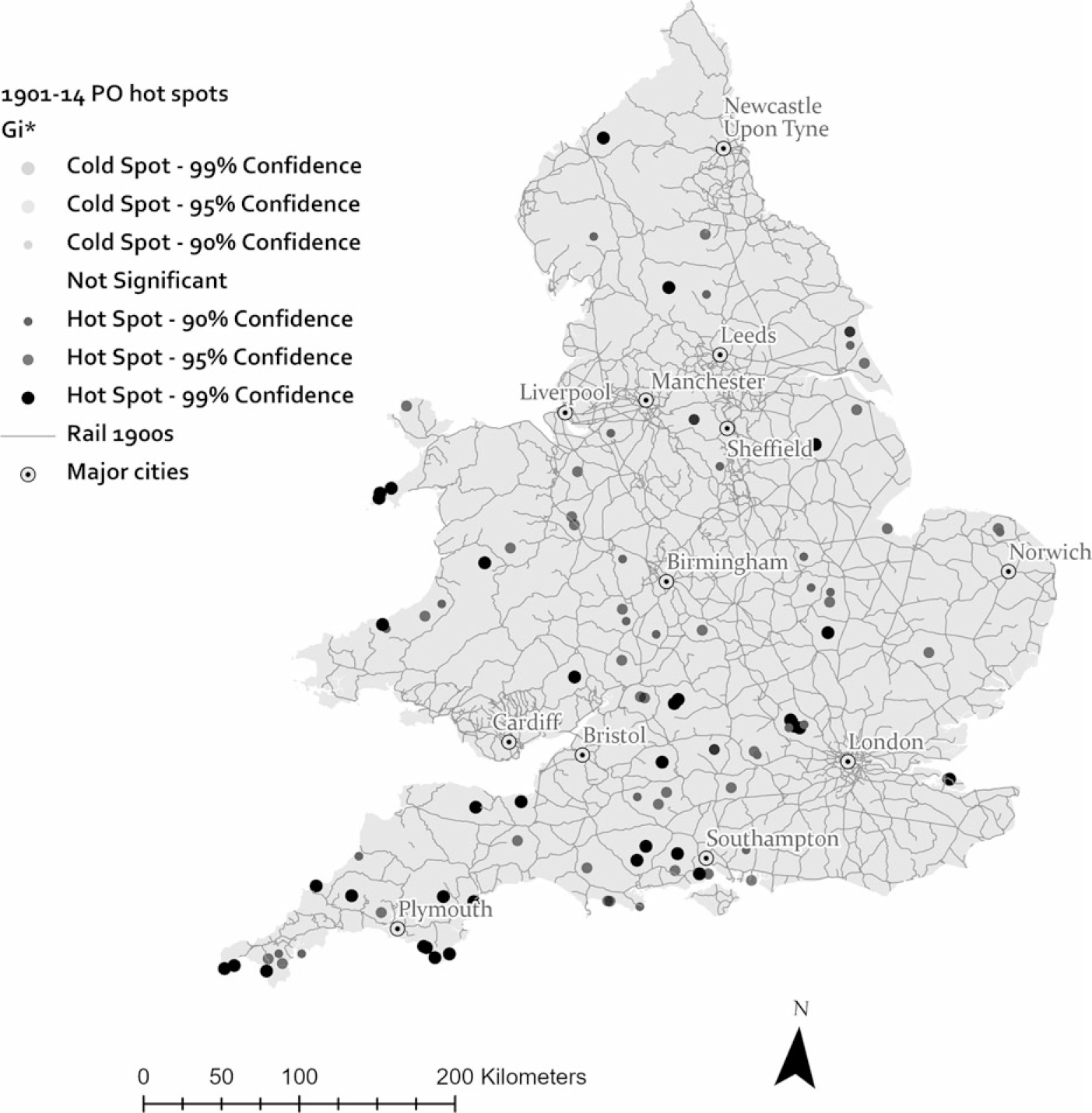
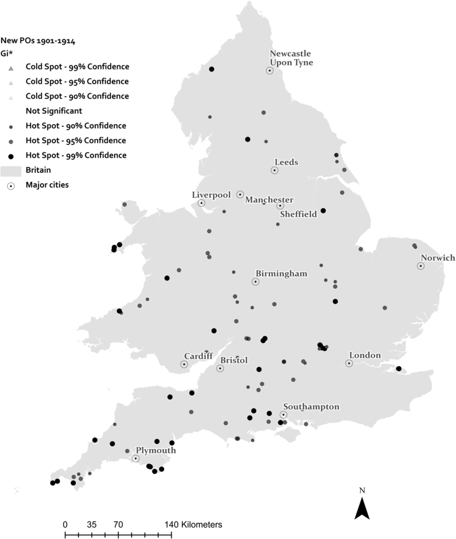
Cluster analysis of post offices opened from 1901 to 1914 and their distances to the nearest railway station.

Le Facteur Rural, 1877.

Interior of a bureau ambulant, 1848.

During the period 1901 to 1914 the desired goal of equity in the placement of new offices in the postal network was more or less realized. Of the offices opened (1,466) those with distant links to rail transport were few in number and widely scattered. Few also were the districts with clusters of outlier offices. All in all, the network in 1914 was made up of 14,536 post offices. The average distance to rail transport was less than 3 kilometers (2.6). In 7 out of every 10 cases a walking postman could carry outgoing mail at his post office to the train station in less than an hour. A horse-drawn van, of course, would arrive sooner. Geographically, the partnership of mail and rail made everyday delivery the norm in all but a relatively few rural communities.
Recipients and Participants: The Meaning of Daily Mail
The regular arrival of daily mail created new expectations in everyday life. Several diary entries of an Oxfordshire farmer suggest how postal service came to be used. One entry from 1893 simply states: “September 1. Sent Mrs. F.W.P. Matthews a brace of Birds to Lynmouth, by parcel post 4d [pence.].” A simple statement of business done at a distance by parcel post. On December 6, 1898, five years later, he exclaimed: “Penny Post, to all our Colonies, commences to-day!!!” (Calvertt and Miller Reference Calvertt and Miller1983: 195, 248).
At the head office in London, Post Master Generals came to be seen as founts of information and assistance. One letter asked the Post Master to dispatch a license for marriage: “Will you please oblige Susannah______ and Walter ______ [surnames omitted] with the particulars of a special license to get married [and] is it possible for you to forward one to us without either of us coming to see you? We’ll be happy to pay the postage.” From the United States, letters asked for help in finding possible family legacies. With your great knowledge of English families, wrote the typical supplicant, I’m sure you can help. A Massachusetts woman hoped to discover the provenance of her lovely London-made clock. In England, a letter from Kent county read: “Will you please inform me if there is to be a Baby show this year at Wollwich … have enclosed a stamp” for the reply. Finally, a hopeful suitor from France, 53 years old, asked the Director of the London Post to discover the whereabouts of a Madame _______ and then to forward to her his proposal of marriage (BPP 1877: 10–12).
Expectations of daily delivery made themselves known when they went unmet. An 1881 newspaper article described the drama and disquiet when an epic snowstorm brought the mail to a halt (Devizes and Wiltshire Gazette, January 27 1881). To make matters worse, the telegraph at the post office was shut down for the day, disrupting communication with London and other localities. Feelings of complete isolation arose. Accustomed to mail and news on a regular basis, no communications with the outside world were troubling. In sum, letter writers, newspaper readers, farmers with products to sell, merchants advertising their wares, the senders of Christmas parcels, and many others—all acquired the habit of using and depending on postal service.
Conclusion: Convergence and Difference
Regular postal communication brought state services to homes in rural communities and remote farmsteads, earned the gratitude of residents thereby, and likely strengthened local sentiments of belonging to the nation. Beginning in 1830, as we have seen, France moved first to get the daily mail to all rural homes using the legwork of thousands of postmen walking designated routes. Both states embraced the principle of equity in postal service so even remote and isolated households would be incorporated into the national postal system. The partnership of mail and rail fostered the application of principle in practice. In 1838 Britain, followed by France in 1854, combined state postal services with the growing railway networks of private companies. Although the plan for universal daily mail in France and Great Britain remained partially incomplete on the eve of the Great War (1914–1918), incremental steps toward the goal had been made. The emerging geography of equity in the establishment of new post offices proves the point.
Differences in scale, terrain, and timing deserve mention as well. The singular differences for France were numerous: the much greater size of French territory, the comparatively vast size of its rural population, its extensive mountainous regions, the later and gradual development of railways and an industrial economy, and the obligation of the Poste to generate a surplus for the state treasury. These characteristic shaped and delayed the modernization of the French Poste. The defeat by Prussia in 1871 and growing international rivalries fortified the republican political will to further postal expansion, defining it as a nation-building project. In this mission, the Rural Service with its 20,000 facteurs rurales was deemed the bearer of national pride and the envy of Europe.
Unlike France, the British state was a supranational organization that ruled over the multinational territories of the British Isles—England, Wales, Scotland, and Ireland. In 1707 the state combined these territories into the United Kingdom. England had always been the dominant country and the predominant power in the British state. As “Britain,” England and Wales were governed essentially as a single polity with uniformity in law and administration. Wars and imperialism gave rise to a British identity in a shared response to external events and foreign foes (see Kumar Reference Kumar2000; Langlands Reference Langlands1999; McCrone Reference McCrone1997).
Arguably, the British program of postal reform and expansion was domestic nation building. The mission inherent in modernizing postal communication was political and cultural integration. In this Britain enjoyed advantages over France. The most important ones were its lead in industrialization, its territorial compactness, the greater density of its rail service, and the fact that the majority of its total population were urban dwellers by mid-century. In contrast to France, the governing authorities strongly held to the conviction that the postal service, especially in the countryside, should be a public utility, not a profit-making resource for the treasury. For these reasons the British partnership of mail and rail matured earlier than that for France. Overall, the results of postal modernization in both France and Great Britain converged.
Acknowledgments
This article is based on research supported by a Grant from the National Endowment for the Humanities and grants from Mount Holyoke College. I am especially grateful to Nicolas Verdier, a CNRS researcher in Paris, who was willing to share his painstaking compilation of French post office names, locations, and dates in existence for the nineteenth century. He cautioned me about the uncertainties in distinguishing postal establishments processing mail as opposed to those devoted to administrative matters. Any errors in my figures in this regard are mine. Thanks as well to Thomas Thevenin of Thèma at the University of Burgundy. In our collaborative work over the years, he supervised the building of our historical GIS of the French railways and added to it communal-level population data and rail accessibility measures. For the British side of my work I am very grateful to Ken Smith and Nick Bridgwater who have created annotated lists of post offices in the United Kingdom by county with the date of opening and closing (https://sites.google.com/site/ukpostofficesbycounty/home). As far as I know this is the only such list of UK post offices in existence. Nick kindly sent me the Word files he compiled prior to posting them in PDF format for the web. Thanks also to my friend and colleague, Paul Dobosh, whose programming skills generated lists that I could use to create a georeferenced database of English and Welsh post offices. Humphrey Southall was very helpful at early stages of the project by providing me with georeferenced data for some 8,000 post offices in England and Wales at the end of the nineteenth century. I also thank Jordi Marti Henneberg who, with help from Meritxell Gallart, Mateu Morillas, and J. Martí-Domínguez, produced the GIS data on British railways taken from Michael H. Cobb, The Railways of Great Britain: An Historical Atlas (Shepperton, 2006; orig. pub. 2003). Ian Gregory, my collaborator on many projects, has given me indispensable help over the years and provided the standardized parish units in georeferenced form (1861–1911) with population figures. Finally, let me thank the staff of the Bibliothèque Historique des Postes et des Télécommunications for their help in my consultations of documents there, and my colleague Frederick McGinness for his eagle-eye proofreading.