

Introduction
The occupation of fortified hilltops was an enduring feature of settlement patterns in southern Caucasia throughout the Bronze Age, Iron Age, and again during the medieval and early modern periods. Today, these places are often remote from population centres and can be challenging to investigate and interpret. They are not always discrete entities, spatially or chronologically, but may consist of components covering expansive areas that were inhabited during multiple phases. Their functions—whether residential, agrarian, administrative, or military—could overlap, and did not necessarily remain constant through time; even at single moments they could have had different meanings to people of differing social status.
Recent investigations at a previously undocumented group of archaeological sites in the Samtskhe-Javakheti region of southern Georgia provide the opportunity to examine highland occupation from a long-term perspective. ‘Varneti’, named after a nearby deserted village, comprises structures, earthworks, and artefact scatters that span a ridge-top of the Erusheti mountain range overlooking the upper Kura river valley near Aspindza (Anderson et al., Reference Anderson, Birkett-Rees, Negus Cleary, Krsmanovic and Tskvitinidze2014: 25–28). From 2013 to 2016, the area was investigated by the Landscape Archaeology in Georgia (LAG) project, a survey programme conducted alongside the Georgian-Australian Investigations in Archaeology (GAIA), a project which has been excavating at Chobareti, 8 km to the north-west of Varneti (Kakhiani et al., Reference Kakhiani, Sagona, Sagona, Kvavadze, Bedianashvili, Massager, Martin, Herrscher, Martkoplishvili, Birkett-Rees and Longford2013). The LAG project's wider study area, which covers some 100 km2, spans the base of the Kura river valley, elevated plains, and highland plateau or pasture (yayla) to the south. Varneti was recognized by our team as being particularly significant, seeming to form a connection between these different ecologies and elevations.
Combined survey methods—including remote sensing using aerial photographs and historical maps, feature recording and surface artefact survey, artefact analysis and radiocarbon dating—have identified material dating from the Chalcolithic (c. 4800–3000 bc), the Early to Middle Bronze Age (hereafter EBA–MBA, c. 3000–1500 bc), the Late Bronze Age to Early or Middle Iron Age (hereafter LBA–EIA or MIA, c. 1500–600 bc) and the high to later medieval period (c. ad 1000–1300). Varneti's position affords relatively easy access from the floor of the Kura river valley to the highland plateau, whose economic and ritual importance is shown by large-scale earthworks, walls, enclosures and burial monuments (Anderson et al., Reference Anderson, Birkett-Rees, Negus Cleary, Krsmanovic and Tskvitinidze2014: 16–17). The sequence of occupation at this transitional point in the landscape, which persisted through varied historical situations, relates to economic and strategic aspects of highland-lowland interconnections in this particular locality, but it also has resonance across the wider southern Caucasus region.
The sites and features recorded at Varneti seem to constitute a distinctive cultural locale or complex, albeit one that is not clearly bounded physically and which became horizontally stratified through episodes of occupation rather than being established as part of a formal scheme of construction. Ground survey methods are well suited to gain overall coverage of the extensive features, but the information gained from surface recording can be inconsistent, imprecise, and has limitations in terms of the interpretations it can support. Therefore, instead of reaching definitive conclusions, we present our results to frame a series of questions regarding the functions and status of Varneti through time, as well as to guide the methods and targets for future investigations.
Farming, Fortification and Highland Occupation
Frequently characterized as both a barrier and a crossroads, the mountainous geography of the southern Caucasus region equally restricts and facilitates movement and interaction. These dualisms serve as a useful framework for studying long-term occupation history, foregrounding human encounters with the environment to examine how terrain, ecology, and climate have been harnessed by past societies whilst also delimiting the ways in which those societies operated. The relationship between lowland and highland locales is a key factor in settlement and land use, routes of movement, and the viability of diversified agro-pastoral farming. The establishment and occupation of fortified positions can be seen in terms of these strategic and economic considerations.
An upturn in international archaeological research in the post-Soviet Caucasus nations over the past twenty years, notably by Project ArAGATS (Archaeology and Geography of Ancient Transcaucasian Societies) in the Armenian Tsaghkahovit plain, has generated substantial data on the region's landscape history (Hopper et al., Reference Hopper, Anderson, Robinson, Anderson, Hopper and Robinson2018). Fieldwork conducted by this and other projects has helped to confirm and challenge previous ideas about the long-term trajectory of human occupation, for instance, showing that EBA villages thrived in highland positions, contrary to earlier suggestions of a progression from sedentary occupation of lowland valleys in the EBA to highland nomadic pastoralism in the MBA (Smith et al., Reference Smith, Badalyan and Avetisyan2009: 394). The work in Armenia has particularly enriched our understanding of fortresses during the LBA to EIA, whose proliferation signals the start of socio-political complexity in which ‘the social inequalities visible in the kurgans of the early second millennium appear to have been formalized into a tightly integrated socio-political apparatus where critical controls over resources—economic, social, sacred—were concentrated within the cyclopean stone masonry walls of powerful new centers’ (Smith et al., Reference Smith, Badalyan and Avetisyan2009: 30).
Survey on the ground has been effective in documenting the distribution of fortified places, which has led to sophisticated interpretations of political authority and territorial sovereignty, for example, examining whether groups of nearby fortresses belonged to a single political authority, whether they operated as individual polities, or were configured into various allied groupings (Smith et al., Reference Smith, Badalyan and Avetisyan2009: 395–97; Greene & Lindsay, Reference Greene and Lindsay2013: 58). At a regional scale, fortified places have often been explained as elements of coordinated strategic systems (Lindsay, Reference Lindsay, Johansen and Bauer2011; Hammer, Reference Hammer2014). LBA-EIA fortresses are characterized as non-urban, military, aristocratic power bases and later Iron Age fortresses are associated with the martial functions of the Urartian state and neighbouring polities (Smith, Reference Smith1999; Smith et al. Reference Smith, Badalyan and Avetisyan2009; Lindsay, Reference Lindsay, Johansen and Bauer2011; Ristvet et al., Reference Ristvet, Gopnik, Bakhshaliyev, Lau, Ashurov and Bryant2012; Hammer, Reference Hammer2014; Deschamps, Reference Deschamps2016). However, the same places can feature occupation which pre- and post-dates the LBA-MIA. Examples include the transformation of EBA villages into fortified strongholds during the LBA (Badalyan et al., Reference Badalyan, Smith, Lindsay, Khatchadourian and Avetisyan2008) and the re-occupation and re-purposing of abandoned LBA fortresses during the later Iron Age; of these, the Achaemenid-period Tsaghkahovit fortress is a particularly well-investigated site (Khatchadorian, Reference Khatchadourian2016: 155–58). In some cases, the occupation of elevated landforms extends further, from before the Bronze Age and into the medieval and post-medieval eras.
Charting the distribution of fortresses at a regional scale has tended to favour interpretations that focus on connectivity between sites rather than on the local landscape dynamics of individual sites. While a regional-scale approach is vital, and GIS-assisted models of settlement patterns, mobility, and visibility are valuable, it may cause the particular characteristics of sites to be overlooked because their functional designation as ‘fortresses’ and inclusion as points on a distribution map privilege systemic explanation and encourage sites to be regarded as homogenous types. Beyond their military status as centres of defence and control, highland fortified places can have complex, discontinuous, and long-term occupation histories involving revived use in differing cultural situations. Episodic yet long-term occupation is a characteristic of Eurasian fortified places, particularly those used by mobile, agro-pastoral groups (Kiani, Reference Kiani1982: 21; Omrani Rekavand et al., Reference Omrani Rekavand, Sauer, Wilkinson, Abbasi, Priestman and Tamak2008: 162–63; Negus Cleary, Reference Negus Cleary and Kardulias2015: 156–57; Reference Negus Cleary, Kim, Vervaet and Adali2017: 289, 293–95). Even for LBA fortresses in Armenia that have been studied in detail, there are no singular, strategic explanations for their location, size, and layout, and the activities associated with the political and religious elites who inhabited them (Greene & Lindsay, Reference Greene and Lindsay2013).
Recent investigations at Varneti shed light on the longevity of occupation at a place which has strategic advantages—both military and agrarian—as an interface between the highlands and lowlands, and between land suited to pastoral and agricultural practices. The findings presented here underline the multi-period and multi-functional qualities of this place to account for the diversity of meanings it held for those who built, inhabited, and visited it at different points in time. We do not advocate indeterminacy; by recording above-ground features we can start to reconstruct the physical contexts where daily practices were enacted and meanings were derived. Fortified places may have both defensive and oppressive qualities dependent on the viewpoint of the subject; on the other hand, their fortified aspect may have been secondary to their residential and agrarian character. Despite the connotations of the term ‘settlement’, they may not have accommodated exclusively sedentary populations but may have served as seasonally occupied bases for semi-mobile populations practising transhumant agro-pastoralism and diverse subsistence strategies. The following sections seek to convey Varneti's potentially multiple and mutable functions whilst highlighting aspects of the landscape that remained constant through time.
Varneti: A Multi-Period Settlement Complex
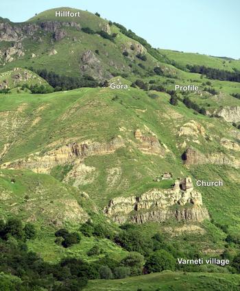
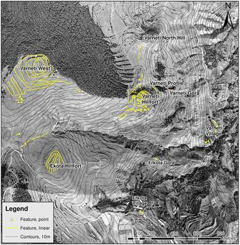
Varneti is located along a high ridge on the western side of the Kura river valley above the town of Aspindza, where the valley curves westwards from its south to north alignment (Figure 1). From the flat alluvial plain, at 1000 m above sea level, the valley side slopes gradually and then more steeply until it becomes a sheer cliff to form a ridgeline which stands at 1600 m asl. At the base of this escarpment is Varneti village, inhabited from the medieval period up to the mid-twentieth century, above which rises a series of cliffs and steep slopes until the land becomes a gently undulating plateau in the south-west (Figure 2).
Map of the upper Kura River valley at Aspindza.

The Varneti sites, viewed from the south.

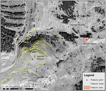
Archaeological features are concentrated along the upper ridge zone and towards the slopes leading to the yayla (pasture; Figure 3). Three adjacent and partially adjoining sites (within an area of 23 hectares) form the core of Varneti archaeological complex (Figure 4): ‘Varneti Gora’ is a steep-sided hillock whose upper slopes may have been artificially built up through repeated occupation; to the north is a landslip where cultural material is exposed (‘Varneti profile’); a prominent hill, Tavghalo, rises to the west, the summit of which is formed by a conical rise (‘Varneti hillfort’) whose sides are substantially modified by ramps and terraces, and a levelled top encircled by a wall. Despite their proximity, the attributes of these sites indicate distinct functions and occupation histories. A central aim of our investigations was to discover how these nearby sites relate to each other and, in turn, to the wider landscape.
Map of sites recorded at Varneti.

Map of the hillfort, Gora and profile sites at Varneti.

Varneti profile
The presence of archaeological remains at Varneti was first reported to our team in 2013 by a villager from nearby Sakudabeli. The eastern edge of a terrace partway up a steep slope had recently fallen away to reveal pottery, lithics, and animal bone (Figure 5). Sediments are exposed along the 21 m-long profile to depths of up to 4 m below the surface. Four stratified soil contexts are distinguished by their consistency, colour, and inclusions. Below the topsoil, from 0.5 m and up to 4 m below ground level, there is a stratum of pale brown silt with angular rocks containing cultural material along its whole length. Beneath it, a dark grey horizon does not contain artefacts; its top interface is relatively flat, perhaps indicating artificial levelling. Rocky colluvium appears below this.
Drawing of the Varneti profile.

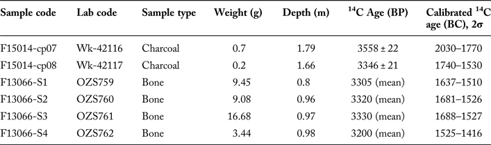
Information on the date of this fortuitously exposed context was obtained by analysing samples of bone and charcoal collected from freshly cleaned stretches of the profile. Radiocarbon analysis of six samples returned ages calibrated to 2030–1469 bc (using Oxcal v.4.2.4 for charcoal and IntCal 13 for bone) (Table 1). Two charcoal samples yielded age estimates of 2030–1530 cal bc, and four bone samples, from shallower depths in the profile, yielded a narrower and later range of 1688–1416 cal bc (2 sigma). That all the samples date from a 500-year window between the late third to mid-second millennium bc, tending towards the latter, raises confidence in the integrity of the contexts from which they were collected.
Radiocarbon determinations for charcoal and bone samples from the Varneti profile.

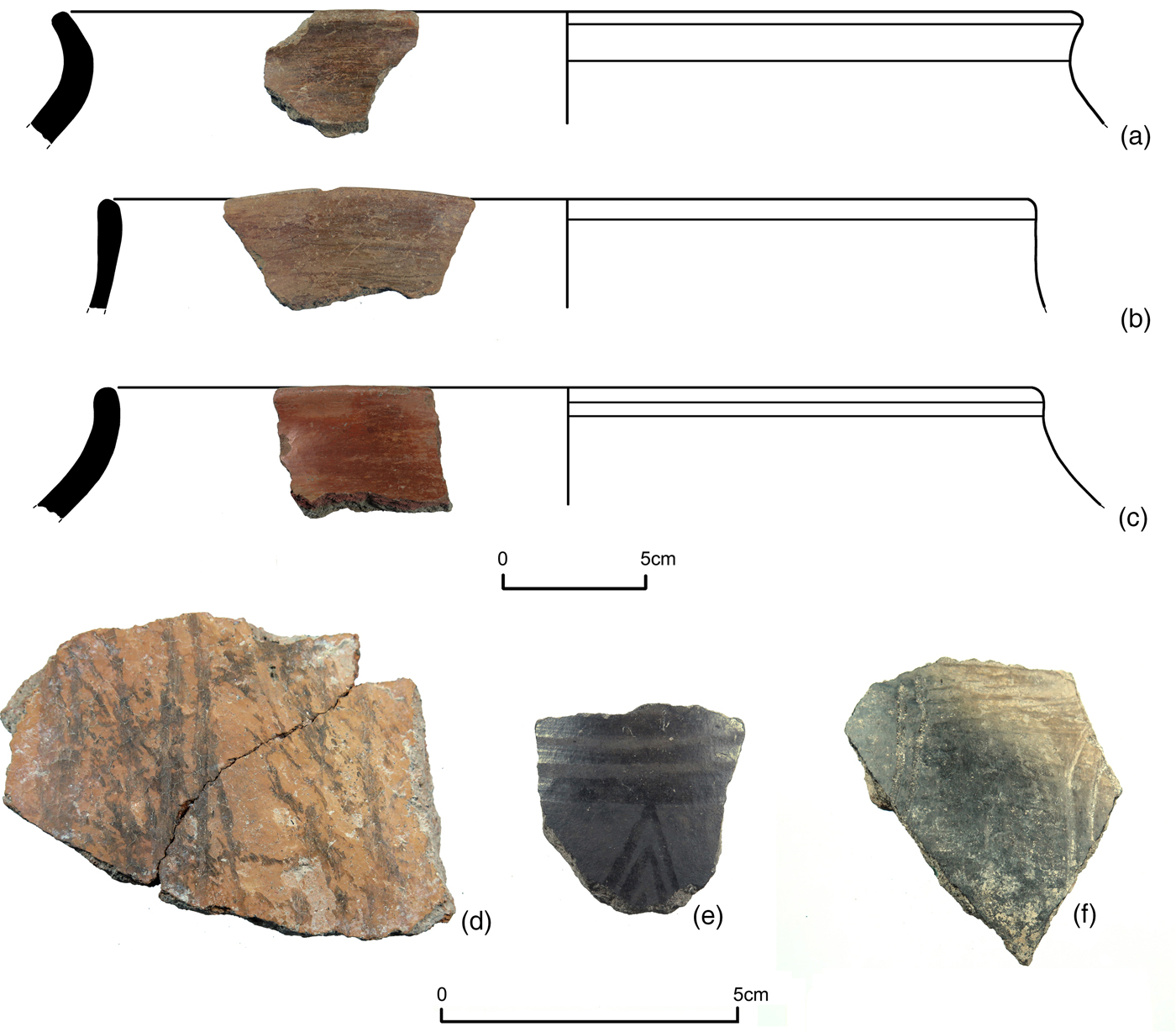
Artefacts were collected from the base of the profile and material exposed in the wall was documented from measured collection points. The integrity of the pottery sherds and consistency in their attributes suggest a secure context. All are hand-made and most are from large, thick-walled vessels with everted rims (Figure 6a–c). Fabrics are gritty, mineral tempered, and red to grey in section; most surfaces are highly burnished, although some have cursory, streaky burnishing (Figure 6d); colours are predominantly reddish brown to greyish brown to black. These attributes align with late styles of Kura-Araxes ware which persist into Period IVB/MBA II levels at Sos Höyük in eastern Turkey (Sagona, Reference Sagona2000: 338–39; Sagona & Sagona, Reference Sagona and Sagona2004: 173–74).
Ceramics from the Varneti profile.

Among the few thin-walled sherds, one has a black surface with a pattern of burnished lines and triangles (Figure 6e). On the whole, however, the collected sherds are from thick-walled and closed vessels which do not have close parallels with ceramics from the numerous MBA burial contexts investigated in southern Caucasia. For example, a MBA burial at Atskuri, on the Kura plain 20 km north of Varneti, contained small, decorated pots and drinking vessels (Licheli & Rusishvili, Reference Licheli, Rusishvili, Sagona and Abramishvili2008); excavated MBA kurgans at Zveli, 7 km from Varneti, also contained fine, decorated ceramics (Gambashidze, Reference Gambashidze1983). Most ceramics from the Varneti profile do not display decorative traits associated with the Trialeti culture, which has been said of finds from the burials at Atskuri and Zveli. Instead, the assemblage has parallels with the cooking and storage vessels from MBA domestic contexts (e.g. Kastl, Reference Kastl, Rubinson and Sagona2008), few of which have been excavated in contrast to the many kurgan burials of the period.
Varneti Gora
Beneath the Varneti profile, a track runs southwards, crossing a stream and rising on a possibly ramped course to the base of a steep hillock with a pointed summit which covers an area of approximately 1400 m2. Its northern side is a short, pine-covered slope, while the bare and eroded southern slope is longer, falling to a rugged tract of hillocks. There are no structural remains visible on the hilltop, but ceramic and lithic artefacts are strewn across the upper slopes and eroding from amongst the tree roots on the north side.
To gain information on the density of the artefact scatter, a point sampling method was deployed by setting out a grid of regularly spaced points, 20 m apart, which were added to the Differential Global Positioning System and draped across the hillside. Each was inspected by recording all material within 2 m of the point for two minutes. Higher quantities of artefacts are present on the upper slopes than the middle and lower slopes. The average artefact count is 3.6 per point; 11 points had no artefacts. There is a ‘hotspot’ towards the west of the upper southern slope where two adjacent points had 29 and 21 artefacts respectively, indicating that material is eroding from buried contexts near the hill's summit. The concentration of artefacts supports the theory that the Gora may once have been a tell-like occupation mound that built up on a natural outcrop.
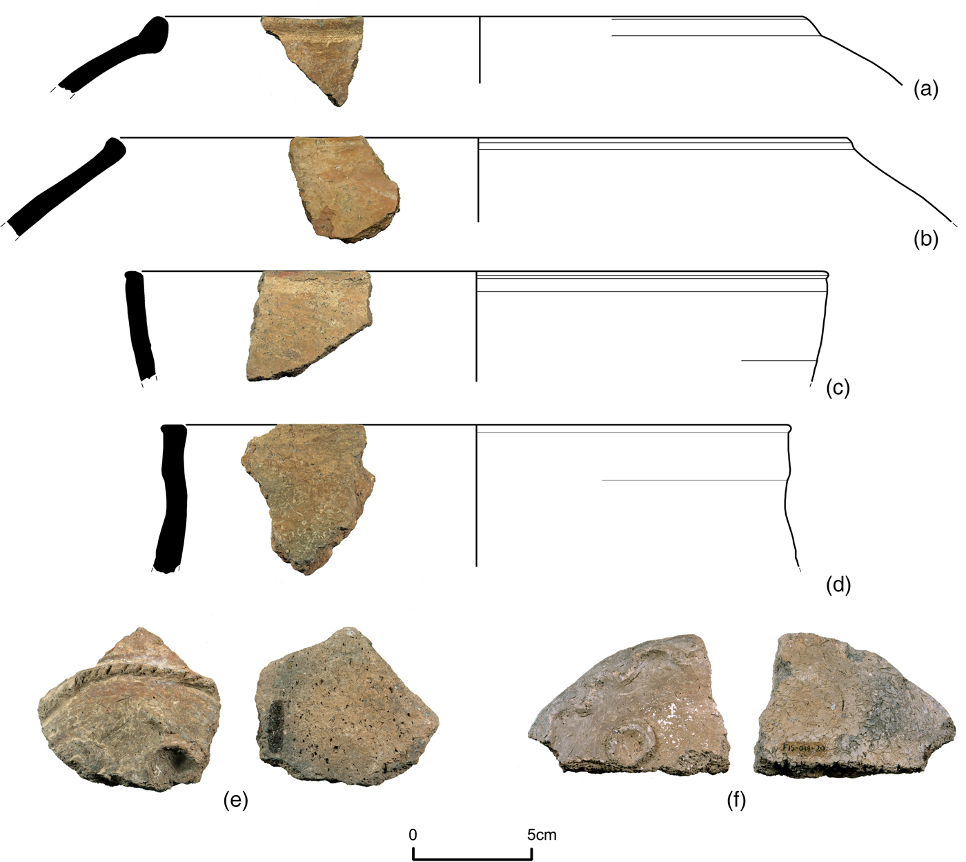
The diversity of artefacts from the Gora suggests occupation over a considerable length of time. One recurring ware is light reddish brown, chaff-tempered and with a burnished exterior; forms include fairly thin-walled but crudely made jars with inverted and upright rims which bear a worn mark directly below the lip (Figure 7a–d). In a similar, chaff-tempered fabric are two intriguing fragments, probably lids, found close to each other but from different objects; they have a flat, untreated underside and on the obverse they are decorated with applied relief patterns of curved lines with notches and circles with finger impressions (Figure 7e–f). The age of the artefacts made in this light brown ware is uncertain: one possibility is that they are Late Chalcolithic but more contextual information is needed to confirm this.
Reddish brown, chaff-tempered sherds from Varneti Gora.

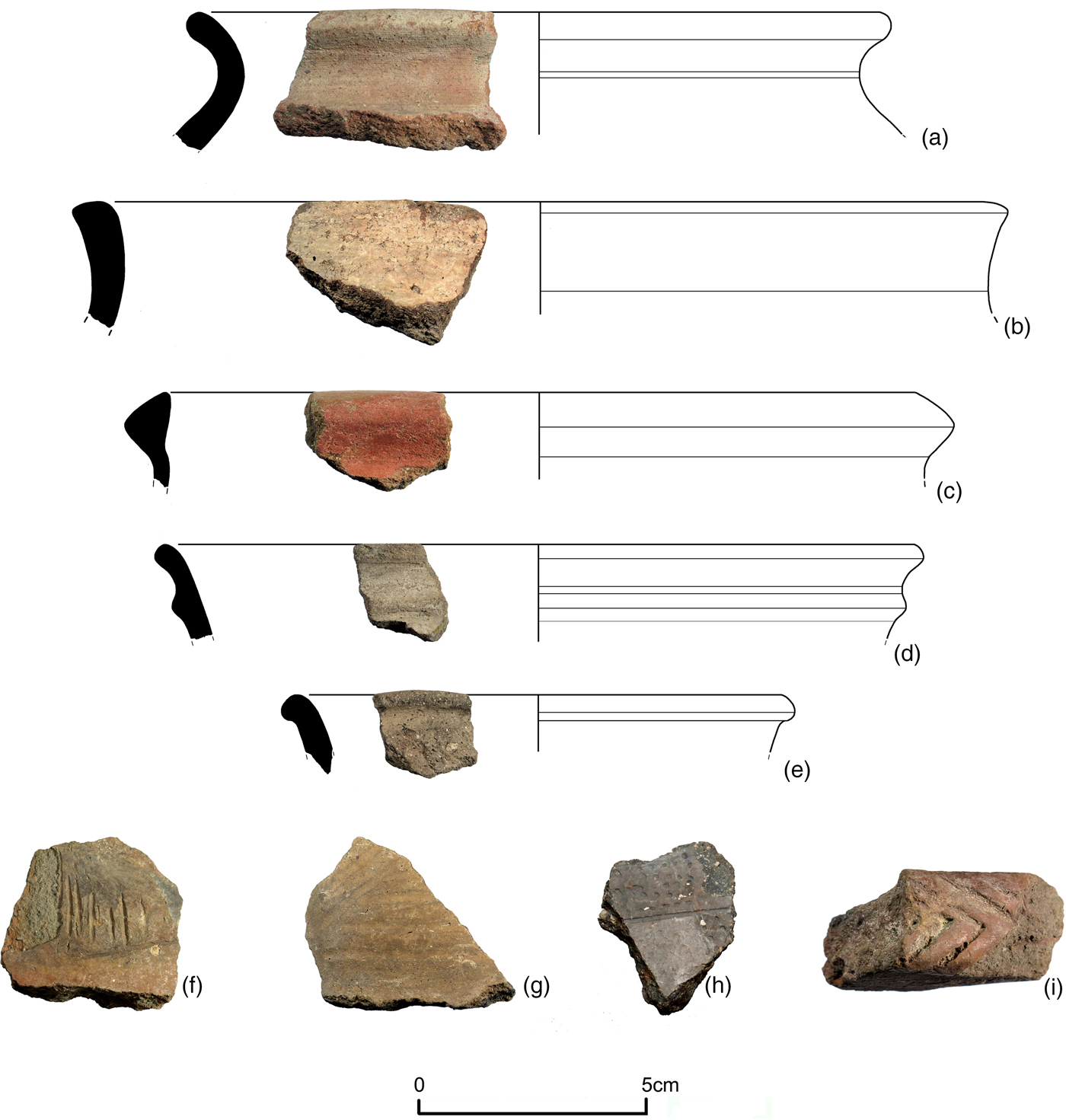
More identifiable EBA and MBA sherds from the Gora include thick-walled, burnished vessels that parallel those at the Varneti profile and EBA handled jars in a fine, sandy fabric with polished black and red surfaces, a type which is not prevalent at Chobareti (Kakhiani et al., Reference Kakhiani, Sagona, Sagona, Kvavadze, Bedianashvili, Massager, Martin, Herrscher, Martkoplishvili, Birkett-Rees and Longford2013: 30). Lithics, which make up 7 per cent of the systematically recorded surface finds, are most likely to be EBA or Chalcolithic; a heavily worked flint biface sickle and obsidian scrapers (Figure 8) feature among the tools collected. Later pottery includes EIA sherds: dark grey fine wares, such as a decorated sherd with a polished black surface and comb-impressed and incised marks, are comparable with finds from floor levels at Sos Höyük dating from the late second to the early first millennium bc (Sagona, Reference Sagona, Çilingiroğlu and Sagona2012: 257–58) (Figure 10 h).
Flint sickle and obsidian scrapers from Varneti Gora.

The Varneti hillfort
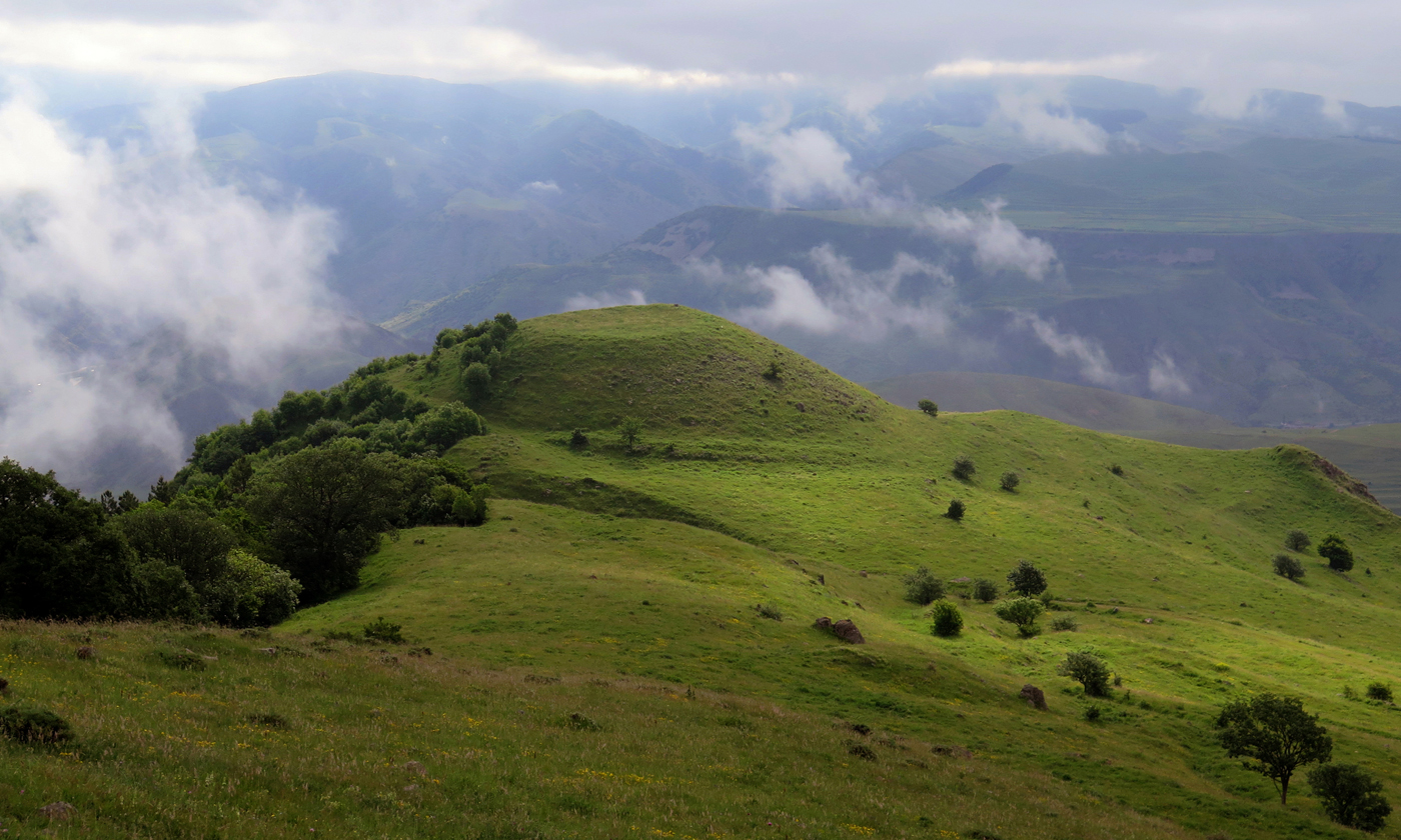
Tavghalo is a steep hill rising to the west of the Gora above the main ridgeline, on top of which is a circular enclosure. Its eastern slope is precipitous but the western and southern slopes are shorter and connect to a flat saddle behind the ridge. Seen from the higher ground to the west, Tavghalo's summit has a conical appearance with terracing, ramps, and levelling clearly visible (Figure 9). The hill stands just to the north of a steep gorge which impedes north-south movement along the ridge, it forms a vantage point with fine views along the ridge and down to the valley and it is conspicuous from below. Therefore, Tavghalo marks a pivotal access point in both its horizontal and vertical dimensions.
The Varneti hillfort, viewed from the west.

LBA-EIA ceramics from the Varneti hillfort.

From its south-western base, a 3 m-wide ramp spirals around the northern face of the hill, ending just short of the summit and overlooking the eastern face's sheer cliff. The whole northern slope is heavily modified with interlocking earthworks in an irregular grid of clockwise and anticlockwise ramps cut into the hillside (Figure 4). These have a disorienting effect, making the slope steeper and less accessible from the north, and their purpose may have been defensive since they seem unsuited to agricultural or settlement purposes. A sub-rectangular enclosure adjoins the hillfort's northern flank, formed by thick, drystone walls, and is likely to post-date the earthworks above.
The level summit of Tavghalo is encircled by a wall enclosing an area of 1100 m2 that is slightly sunken below the crest. An exposed section of the circuit wall on the northern side is up to 1.6 m thick, although its make-up varies and includes vestiges of adjoining structures —perhaps towers or bastions—at the east and south. These structural remains support our characterisation of Tavghalo's summit as a ‘hillfort’. At the base of the hill's short, southern side, the relatively gentle slope has been benched in curvilinear terraces along which are piles of fieldstone that suggest former habitation, perhaps of an itinerant nature, an intermittently occupied settlement of the sort that are still used by herders in summer months on the yayla.
There is a concentrated spread of surface ceramics on the hillfort's southern slope, more so than the equivalent slope at Varneti Gora. Using the same point sampling survey method, we recorded an average of 5.6 artefacts from 49 inspected points. The highest artefact counts come from 5–10 m below the summit, where the average count per point is 11.6. Points on the lower slopes, 17–22 m below the summit, yielded no more than one artefact each. Like the Gora, this indicates that the material is eroding from the upper slopes.
The artefacts are more diverse than at the Gora and there are differences in their attributes. EBA and MBA wares prevalent at the Gora site and the Varneti profile are present but not as common on the hillfort and there are fewer lithics (just 1 per cent of the systematically recorded artefacts). Instead, assorted LBA-EIA and medieval sherds constitute the bulk of finds. Certain wares and shapes not found elsewhere at Varneti underline the site's distinctive character, as do imported ceramics and evidence for production in the form of overfired wasters. Ceramics assigned to the LBA include wheel-made, red, and cream-slipped jars, including a cream-slipped orange ware (Sagona & Sagona, Reference Sagona and Sagona2004: 180–81; Sagona Reference Sagona, Çilingiroğlu and Sagona2012: 256–57, fig. 2.3) (Figure 10a–c). Grey and dark grey gritty ware bowls with grooved profiles are of probable EIA-MIA date (Figure 10d–e); sherds with incised decoration, such as one with incised herringbone pattern, suggests activity continuing into the MIA, around 800–600 bc (Ristvet et al., Reference Ristvet, Gopnik, Bakhshaliyev, Lau, Ashurov and Bryant2012: 345–46) (Figure 10i), and a few highly polished, thin-walled red ware sherds may also be MIA, although they are insufficient in number and integrity to allow for their identification as ‘Urartian’.
There are no indications of occupation at the hillfort in the later Iron Age or for several centuries afterwards, but abundant medieval ceramics show that it was again settled more than a thousand years after its probable abandonment before the mid-first millennium bc. This might coincide with the foundation or flourishing of the Varneti settlement, where the church (named Kviratkhoveli, denoting its dedication to Renewal Sunday) stands precariously on a steep bluff jutting out from the cliff below Varneti Gora (Figure 11). Tiles found on the surface of the hillfort, some 300 m higher in elevation than Varneti village, match those built into the wall of Kviratkhoveli Church, and may be contemporary with its construction in perhaps the twelfth century, although the purported discovery of an early medieval volute capital suggest that a church at Varneti had already existed some centuries earlier (Gverdtsiteli, Reference Gverdtsiteli1979: 305).
Varneti church (a) view from the south; (b) tiles built into the apse wall; (c) tile from the surface at Varneti hillfort.

Along the Ridgeline
Further signs of occupation occur along the ridgeline to the immediate north and south of the ‘core’ sites described above. Running north of Tavghalo is a long, curving embankment that bends to the northeast. This has the appearance of a causeway, 250 m in length, which links to the western side of a steep and rocky eminence, the ‘North Hill’, where there is a light scatter of ceramics on the upper slopes. The embankment bridges the saddle between here and Tavghalo, and probably relates to the occupation of these locales. It encloses a relatively level area where there are accumulations of huge boulders, likely to be cultural features, and it may have served as a barrier that would have both contained and facilitated movement.
In the opposite direction, to the south of Tavghalo, the ground falls to a rugged area of hillocks behind the main ridge, but on inspection no cultural material was found on their eroded slopes. The hillock field is curtailed to the south by a deep, gully aligned east-west, beyond which lies Erkota, a seasonally occupied hamlet where there is a renovated (though now disused) medieval church. A rounded hill north of Erkota (Lekmitzebi) marks the limits of the steep section of ridge. On its summit are partially exposed wall lines; ceramics on the uppermost, south-facing slope include EBA/MBA brown-burnished wares and some later material, including a sherd of red fineware, one of the few artefacts from Varneti that may be assigned to the late antique period.
South-west of Varneti stands a hill known locally as Ina'satibe, which has an elongated summit aligned north-south and is 150 m long. A clearly defined wall runs along its eastern crest; it does not appear to from a complete circuit around the summit, perhaps indicating the need to defend this side or to display the hill's strength to viewers in the valley below. The terraced western slope is gentler than the east and transitions into a shallow valley whose western side rises towards a looming hill―Chortis Tavebi―that forms the true transition to the yayla. This hill's slopes are modified by massive terraces at regular intervals which are steep and broad. Seen from above, the terracing forms a series of concentric squares, but on the ground some of the terraces are connected with each other by ramps; aerial imagery from the mid-twentieth century shows that these terraces were the result of modern mechanized farming, although they may have overlaid earlier earthworks. Given its proximity to Tavghalo, and being the highest point in the locality, Chortis Tavebi is an important landmark, forming the interface between the valley and the plateau.
Discussion
The features recorded at Varneti point to the long-term significance of this place in the landscape of the upper Kura river valley. The adjoining, partially connected and separate components of this complex—all within an approximately 1 km-long stretch of the ridge—have varied but overlapping chronologies. It should be noted that the designation of Varneti as a ‘complex’ is a term of convenience which does not imply that the components formed part of an overall scheme. Moreover, through some five millennia of occupation, there appear to have been long phases of abandonment, for example from the mid-first millennium bc to the later first millennium ad, preceded and followed by spells of intensive activity. These attributes (detached zones of settlement and episodic spans of occupation) show that Varneti retained its importance through varied climatic and cultural conditions. In conclusion, we consider why this was the case and advance some lines of interpretation which set out the direction, methods and targets for further investigation. Two related sets of questions are raised by our fieldwork: first, concerning the sequence of occupation, and second, the nature and functions of the place.
From the evidence presented, we can sketch an approximate chronology. The Gora yielded the oldest material, including Chalcolithic-EBA ceramics and lithics; Varneti profile is more confidently dated to the first half of the second millennium bc, or the later MBA, and the buried deposits, such as thick-walled storage vessels and the bones of domesticates including cow and sheep, suggest habitation; at Varneti hillfort, LBA-EIA and medieval artefacts are prominent. Beyond this ‘core’ area, EBA-EIA finds were recorded on hilltops along the ridge to the north and south. Following a hiatus of more than a thousand years starting in the later Iron Age, a medieval settlement was established at the foot of the upper ridge's cliff. This settlement continued for several hundred years. Varneti was recorded in the 1595 Ottoman taxation census (defter), the Vilayet of Gurjistan, as housing 13 male (Christian) landowners, agro-pastoral farmers who grew cereal crops (mostly wheat and barley) and kept sheep, pigs, and bees (Negus Cleary et al., Reference Negus Cleary, Tskvitinidze, Anderson, Krsmanovic, Birkett-Rees, Batmaz, Bedianashvili, Michalewicz and Robinson2018), and the village was only abandoned, reportedly due to malaria, in the mid-twentieth century.
Varneti was therefore inhabited through the various social and political regimes that typify the epochs of the late prehistoric southern Caucasus, from the establishment of villages in the EBA to the nomadic pastoralism of the MBA, and the formation of fortress-based complex societies in the LBA-EIA. This serves as a reminder that general rules about the shifting location and nature of settlements through time are not universally applicable and that a locale such as Varneti could accommodate varied economic and political structures. After all, each of these epochs span several hundred years, and it cannot be assumed that the situation would remain static through such lengths of time; indeed, stasis would be more unusual. Perhaps, then, we are seeing a place whose longevity is due to its adaptability in differing cultural, political, economic, and environmental circumstances.
The multivalent qualities of Varneti extend to the composition of the artefact assemblages recorded on its surface. Although the material from each locale displays distinctive characteristics, there is a degree of overlap in its chronology and nature. Furthermore, the assemblages are complex, appearing to reflect both highly local traditions and a degree of inter-regional connection, as well as characteristics that straddle recognized periods and cultural traits, as shown for example by the persistence of Kura-Araxes style pottery into the MBA. Most ceramics from the mid-second millennium context at Varneti profile are domestic and utilitarian vessels rather than the decorated objects from the kurgan burials which allowed archaeologists in the twentieth century to identify a ‘Meskhetian variation of the Trialeti culture’ in the district between Zveli and Vardzia (Kakhiani et al., Reference Kakhiani, Sagona, Sagona, Kvavadze, Bedianashvili, Massager, Martin, Herrscher, Martkoplishvili, Birkett-Rees and Longford2013: 4). The thick-walled storage and cooking vessels and animal bones suggest a semi-sedentary, pastoralist population, a significant result for understanding the transition from settled and agrarian to nomadic pastoral farming in the MBA of southern Caucasia (Greene & Lindsay, Reference Greene and Lindsay2013: 56).
Chalcolithic, EBA, MBA and EIA artefacts were recovered on the slopes of the nearby site of Gora, while the eclectic material from the hillfort dates mostly from the LBA-EIA and the medieval periods. These differences, while not useful for quantification on the basis of surface collection, point to changes in the function and character of occupation through time. Having been settled from the Chalcolithic to the MBA (though perhaps intermittently and seasonally), Varneti's development into a fortified place appears to have been an innovation of the late second millennium, echoing the sequence at Gegharot on the Tsaghkahovit plain, where an EBA village preceded the hill's conversion into a fortress during the LBA (Badalyan et al., Reference Badalyan, Smith, Lindsay, Khatchadourian and Avetisyan2008). Combined residential and strategic functions are suggested by the form of the earthworks, such as ramped and spiralling terraces at Tavghalo, while on-site craft production is indicated by ceramic wasters and diverse forms made from the same basic fabrics. The divergent uses of particular landforms lead us to consider the reasons for occupying this highland zone, and how these may have varied or remained constant through time.
Despite the challenges of using surface evidence to characterize Varneti through time, we are nonetheless able to relate its physical attributes with its landscape context. The high ridge where Varneti is situated occupies a transitional zone between the river valley and the highland plateau. Further along the ridge, to the north-west, a chain of multi-period hilltop and mounded sites (at Orgora, Zveli and Chobareti) also overlooks the Kura valley (Anderson et al., Reference Anderson, Birkett-Rees, Negus Cleary, Krsmanovic and Tskvitinidze2014). Varneti is distinctive because the route from valley floor to plateau is shorter and more accessible and because it is sited above a strategically significant point at Aspindza, where the valley changes course and thins to a narrow gorge. Varneti might, then, have served as a place of surveillance, a refuge and a gateway or staging post, where movement between ecological niches was regulated and activities associated with the valley and plateau were mediated. The location overlooks the valley floor far below, and this elevated position may have had symbolic as well as strategic qualities. While overseeing the movement of people and goods along the river valley was important, its significance was equally if not more important in the vertical dimension, where access to the plateau—whose economic and ritual aspects are materialized in enclosures and linear features, cemeteries, and megalithic monuments—could be regulated.
The diachronic quality of Varneti raises the question of why highland occupation flourished at some times and not others. From the perspective of cultural ecology, we can consider the relational factors of physical environment and political and cultural circumstances as influencing the preference for upland settlement, be it itinerant, seasonal, or permanent in nature. Recent surveys in the district immediately to the south have identified that fortified places (most of medieval date but including places with EBA-EIA evidence) are located either on high rocky outcrops or along rivers, particularly at confluences, a pattern related to the oversight and control of routes and passes connecting valleys and plains (Khaburzania & Robinson, Reference Khaburzania, Robinson, Batmaz, Bedianashvili, Michalewicz and Robinson2018). This applies also to Varneti, whose ‘gateway’ status may have assumed increased importance at moments when the need for access and control of the lowland/highland axis became more acute. We can therefore infer that Varneti experienced intensified occupation when access was closely controlled and that an established social system or political authority existed to exert that control.
Related to ideas of political authority are questions surrounding the agro-pastoral economy. Investigations in Armenia have found LBA fortified sites clustered in foothills on the edges of arable plains, allowing fortress-based polities to control agricultural land (Smith et al., Reference Smith, Badalyan and Avetisyan2009: 396; Hammer, Reference Hammer2014), although this may have taken the form of remotely monitoring access rather than direct surveillance (Greene & Lindsay, Reference Greene and Lindsay2013: 64–65). The LBA settlement at Tsaghkahovit South Lower Town, for example, is characterized as a ‘domestic complex occupied intermittently by seasonally mobile groups’ (Badalyan et al., Reference Badalyan, Smith, Lindsay, Harutyunyan, Greene, Marshall, Monahan and Hovsepyan2014: 193–98), albeit with access to fields for growing crops. At Varneti, the topographic situation is different: there are no extensive plains and cultivatable areas in the immediate vicinity are limited. While large-scale, curvilinear terracing that runs along the contours of the valley's middle slopes is a signature of agriculture (though at what time is uncertain), and archaeobotanical evidence from nearby Chobareti, also in an elevated valley position, shows that cereal growing was important to the EBA inhabitants of that settlement (Messager et al., Reference Messager, Herrscher, Martin, Kvavadze, Martkoplishvili, Delhon, Kakhiani, Bedianashvili, Sagona, Bitadze, Poulmarc'h, Guy and Lordkipanidze2015), Varneti is some distance from arable land and water for irrigation. This suggests that mobile pastoralism was the dominant mode of farming, and further suggests that occupation and abandonment may relate to the fluctuating importance of pastoral practices and the degree of mobility. Again, more data are needed to support this theory, but it can be said that the situation at Varneti suited populations capable of moving between highland pastures and lowland valleys.
A variety of social and economic models would have operated through Varneti's long occupation history. The dispersed and diverse nature of the main components that we have recorded supports the idea of a place that could have functioned as a pastoral farming community, a militarized stronghold, or perhaps both at the same time. The eclectic forms of terracing and earthworks are indicative of these multiple facets. The construction of terraces may have been a collective enterprise by communities with shared interests and bound by kinship ties. Alternatively, large-scale land modification may have required a central authority and planning, perhaps involving the coercion of a workforce. The varied morphology of earthworks with defensive, residential, and agricultural purposes could provide clues about the prevailing social conditions at the time that they were constructed.
Although the initial results from Varneti seem to raise many questions regarding the nature of highland occupation in southern Caucasia, they contribute important new information on the nature of such occupation and confirm Varneti as a significant place in the prehistoric and medieval landscape of the upper Kura river basin. Our surveys have identified certain phases of intensive activity, from settlement in the Chalcolithic/EBA-MBA to fortification works probably dating to the LBA-EIA and, following a millennium-long hiatus, medieval occupation. This sequence has significant implications for understanding the long-term trajectory of settlement in the southern Caucasus highlands. While survey provides the basis of information about the extent and layout of archaeological features at Varneti, further investigations will seek to clarify the sequence and character of occupation. Targeted excavations and geophysical survey at the identified ‘core’ sites, combined with survey of the wider surroundings, will establish with more certainty the relationship of Varneti with the valley floor and the yayla. These may help to confirm the idea that Varneti was a gateway, where movement and practices between lowlands and uplands were mediated and whose importance endured through contrasting social, political, and environmental conditions.
Acknowledgments
This research was supported by the National Geographic Waitt Grants Program under grant number W370-15; the Australian Institute of Nuclear Science and Engineering (AINSE) Research Award under grant number ALNGRA15009; and the University of Sydney Dorothy Cameron Fellowship. The LAG Project was started with the encouragement of Professor Tony Sagona, who sadly passed away in 2017. We thank him and his co-director, Dr Kakha Kakhiani, as well as Dr Claudia Sagona and Dr Giorgi Bedianashvili for their support and enthusiasm, and also Professor David Lordkipanidze (Georgian National Museum) for permission to carry out our surveys. Radiocarbon dating analysis was conducted by the Waikato Radiocarbon Dating Laboratory and the Australian Institute of Nuclear Science and Engineering.