Introduction and regional setting
South Greenland is close to the main track of cyclone systems crossing the North Atlantic on their way towards the region of Iceland. The area therefore has the potential to provide crucial information on major shifts in the north Atlantic atmospheric circulation pattern and general climate regime. Soil erosion and aeolian sediment deposits are found in a few areas of south Greenland, especially in the area adjacent to Igaliku Fjord, where the former Eastern Settlement of Norse society was located (Figs. 1, 2). The first topographical–archaeological investigations in this area were carried out at the end of the 19th century by G. Holm and G. Bruun (Holm Reference Holm1883; Bruun Reference Bruun1895). The most severe soil erosion seems to have taken place here at the end of the Norse era (Sandgren and Fredskild Reference Sandgren and Fredskild1991). Erosion may still have persisted some time after the Norse had disappeared (Fredskild Reference Fredskild1992), which probably was around AD 1430 (Arneborg and others Reference Arneborg, Heinemeier, Lynnerup, Nielsen, Rud and Sveinbjørnsdottir1999). Palaeo–botanical investigations in south Greenland show that wet and dry periods alternated during the first part of the last millenium, with dry conditions prevailing around AD 1000 (Fredskild Reference Fredskild1978). The oscillation between dry and wet episodes seems to parallel variations in the isotope data of the Greenland ice cores (Stuiver and others Reference Stuiver, Grootes and Braziunas1995). Wet and dry periods reflect changes in the regional atmospheric circulation pattern that also implies variations in wind strength. During the same period markedly changing wind conditions also occurred over northeast Canada as reported by Kasper and Allard (Reference Kasper and Allard2001).

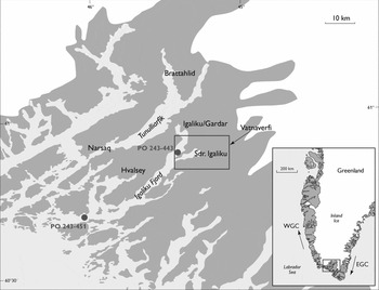
Map of southern Greenland showing the Vatnaverfi investigation area (square) that is partly seen in Fig. 3. The small insert map shows the regional setting of the study area in south Greenland. Arrows indicate surface currents: the cold, ice–loaded East Greenland Current (EGC); the West Greenland Current (WGC) which transports both Irminger Current water and water derived from the East Greenland Current northwards along the west Greenland coast.

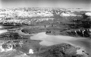
The Eastern Settlement in southwest Greenland is characterised by the presence of two major fjord systems, the Tunulliarfik Fjord which hosted the first Norse homestead (Brathalid) dating from AD 985, and Igaliku Fjord where the Norse episcopal seat of Gardar was located (Fig. 2). In Vatnaverfi adjacent to Igaliku Fjord ruins of numerous Norse homesteads witness the former agricultural activities of these people (Vebæk Reference Vebæk1992). A well developed sandur is located in front of two major glaciers descending from the inland ice northeast of Vatnaverfi (Fig. 3). An elongated lobe of aeolian sand extends from this sandur west–southwest into the Vatnaverfi area, where numerous lakes, ponds and smaller streams are present.
Aerial photograph of the Vatnaverfi area looking in an east southeast direction (for regional setting, see Fig. 2). Locations of the aeolian sections dealt with (Sections 1A, 1B, 2 and 3) are shown as well as the location of one of the marine sediment cores (M; core PO-243-443).

The climate of Vatnaverfi is subarctic/subcontinental in the inner parts and more maritime towards the coast. A characteristic feature of the local climate is the occasional occurrence of very strong foehn (katabatic) winds reaching velocities of more than 40 m/s. These katabatic winds originate from the inland ice and are strongly controlled by topography. They are most frequent in winter and springtime, and have a dominant influence on the erosion and aeolian deposition pattern of the area (Jacobsen Reference Jacobsen1987).
The hydrography of the fjords in this area (Horsted Reference Horsted1956) is strongly influenced by cold, low salinity surface water masses from the East Greenland Current (EGC) (Fig. 2) entering the outer fjord, whereas at depth relatively warm (up to c. 4°) and saline Atlantic water derived from the Irminger Current is found. Presently, a clear seasonal trend is observed with cold EGC water masses dominating until (late) summer, after which (sub) surface warming with an increased influence of Atlantic water prevails until early winter (Horsted Reference Horsted1956). In the inner part of Igaliku Fjord meltwater discharge from the inland ice is significant and lower salinities prevail in most of the water column.
Sedimentary record
Two gravity cores, PO-243-443 and PO-243-451, were retrieved in the inner and outermost part of Igaliku Fjord (Fig. 2) (Hoffmann and others Reference Hoffmann, Kuijpers, Thiede and Shipboard1999; Kuijpers and others Reference Kuijpers, Abrahamsen, Hoffmann, Hühnerbach, Konradi, Kunzendorf, Mikkelsen, Thiede and Weinrebe1999). They provide important information on the changing climatic regime of the area during the last 1000 years and document enhanced wind–induced mixing of the water column in the interval AD 900–1300 (Lassen and others Reference Lassen, Kuijpers, Kunzendorf, Hoffmann-Wieck, Mikkelsen and Konradi2004; Jensen and others Reference Jensen, Kuijpers, Koc and Heinemeier2004; Roncaglia and Kuijpers Reference Roncaglia and Kuijpers2004). In addition, diatom analyses of the core located in the inner part of the fjord (see M in Fig. 3) yield evidence of marked hydrographic changes in a relatively short time span beginning at about AD 1300 and culminating around AD 1500 (Jensen and others Reference Jensen, Kuijpers, Koc and Heinemeier2004). This period marks the transition from the Medieval Warm Period to the Little Ice Age, and is characterised by increased inflow of polar (EGC) waters into the inner part of Igaliku Fjord and a shorter ice free season than conditions in the past century as reported by Horsted (Reference Horsted1956). Moreover, on the southeast Greenland shelf, Jensen (Reference Jensen2003) found marked fluctuations of EGC activity at multi–decadal to centennial scale, becoming more pronounced after c. AD 1200.
Terrestrial aeolian deposits are found at several localities in the Vatnaverfi area. For the present discussion the newly studied record from onshore sections sampled in recent years (for example Mikkelsen and others Reference Mikkelsen, Kuijpers, Lassen and Vedel2001) is combined with information from the above marine records. The onshore aeolian Section 1A (Fig. 4) is located close to the coast in the area of the former Norse settlement of Søndre Igaliku (Fig. 3).
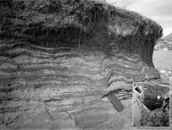
Section 1A at Sdr. Igaliku displaying aeolian sand units alternating with more clay rich horizons (darker coloured). The insert shows the dated grey, organic rich basal layer indicated by arrow. Note book (18 cm long) for scale.

This profile is 120 cm high and shows aeolian sand units separated by more clay–rich horizons suggesting beginning soil formation and less wind activity. The aeolian sand sequence rests on a grey and organic rich basal layer. In Section 1B in the immediate vicinity of Section 1A a rusted food tin was found in the uppermost aeolian unit. Section 1B shows the same type of alternation, but with thicker individual aeolian units than seen in Section 1A. Section 1B was observed in 2001 to have a well developed vegetated soil on top of the upper aeolian unit.
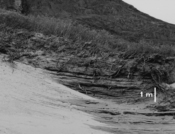
Section 2 (Fig. 5) in inland Vatnaverfi and adjacent to the Norse ruin complex Ø 64C, is located much closer to the sandur than the above described sections (Fig. 3), and is close to the main active sand transport pathway. Therefore Section 2 displays much thicker aeolian sand units than observed in the other sections. Section 2 shows a c. 6 m thick succession of 10–12 light-brownish, composite sand beds some of them containing visible sub-units. The sequence overlies the grey and organic rich basal layer as observed in Section 1A. This grey basal layer has been reported to be widespread in Vatnaverfi by Jakobsen (Reference Jakobsen1991), and its presence was also confirmed below aeolian sediments of Section 3, which displays a condensed (< 0.5 m) section in an erosional setting (Fig. 3).
Section 2 located adjacent to the Norse ruin complex Ø64C showing a series of composite aeolian sand units. The grey basal layer is not visibly exposed on this photo but was sampled in a dug out at the base of the section. Scale bar is 1m.

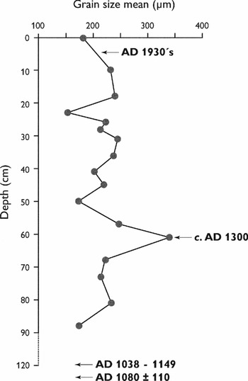
The 120 cm high profile of Section 1 (Fig. 4) shows a series of 17 aeolian sand units separated by more clay rich horizons suggesting beginning soil formation and less wind activity. From this section, samples were taken for grain size analyses of all 17 individual aeolian sand beds. The more clay rich intercalated horizons were not sampled. A coarser fraction (>1700 μm) was found to be absent in virtually all samples analysed. The mean grain size of the sampled aeolian sand units from Section 1A is presented in Fig. 6. Only samples from the uppermost 18 cm of the profile contain organic material, mainly grass roots from present vegetation. All samples are well sorted, with higher (>240 μm) mean grain size values occurring at the 31 cm, 57 cm and 61 cm levels, as well as near the top of the section. The coarsest unit is found at 61 cm. Thus, the most prominent episodes of maximum wind energy are suggested to be represented by the 57–61 cm depth interval. The lowest (≤200 μm) mean grain sizes are observed at the bottom of the section at depths of 88 cm, 50 cm, and 23 cm and at the top of the section.
Mean grain size (fraction < 1700 (m) of all individual, well sorted aeolian sand beds of Section 1A and tentative chronology of the section. For discussion of the chronology, see text.

Chronology
The organic rich basal layer was sampled for AMS 14C dating at all three locations (Fig. 3). The radiocarbon dating was carried out at Kiel University, Germany. Conventional 14C ages were calculated according to Stuiver and Polach (Reference Stuiver and Polach1977). Calibrated or calendar ages were calculated using ‘CALIB rev 4.3’ (Stuiver and others Reference Stuiver, Reimer, Bard, Beck, Burr, Hughen, Kromer, Mccormac, Van Der Plicht and Spurk1998). All ages are referred to as calibrated ages (cal AD). The layer in Section 2 yielded a well defined age of AD 1020 with an accuracy of only about a decade (dating no. KIA 27999). 14C dating of the basal layer at Sections 1A and 3 show ages of between AD 1038 and 1149 (dating no. KIA 27997) and between AD 1035 and 1145 (dating no. KIA 27998) respectively and with an accuracy of ± 25 years.
In addition to the organic 14C dating thermoluminescence dating was performed at the Nordic Laboratory for Luminescence Dating at Risø, Denmark. Analysis of a sample from the base of the aeolian sand succession of Section 2 just above the grey organic rich basal layer yielded an age of AD 960 ± 80 years (Risø lab. no. 011201).
Thermoluminescence measurements were further applied with the aim of obtaining ages from within the aeolian sequence of Section 1A. However, both at the Risø laboratory (A. Murray, personal communication, 2006) and at the laboratory of the University of Bayreuth, Germany, (M. Fuchs, personal communication, 2006), these attempts were unsuccessful due to poor bleaching characteristics. According to the latter laboratory an age in the range of the Medieval Warm Period can, however, not be excluded for samples from the lower part of Section 1A (79 cm and 115 cm depth). As for dating of the uppermost aeolian unit a rusted tin can was found in this unit of dune Section 1B located in the immediate vicinity of Section 1A. Tin cans came into use after 1900, which thus provides a maximum age for this top unit.
Discussion
Studies of the terrestrial aeolian deposits in southern Greenland provide evidence for long term variations in wind strength during the past millennium. Also studies of a marine core from the entrance to Igaliku Fjord conclude that during this period an episode of enhanced wind stress occurred, which had started around AD 900 and ended at about AD 1300 (Lassen and others Reference Lassen, Kuijpers, Kunzendorf, Hoffmann-Wieck, Mikkelsen and Konradi2004; Roncaglia and Kuijpers Reference Roncaglia and Kuijpers2004). This implies that the initial stage of wind activity started prior to the arrival of the Norse as also witnessed by an increase in the sand content prior to the appearance of domestic plant pollen in dated pollen profiles (Fredskild Reference Fredskild1992). Apparently further intensification of atmospheric circulation occurred shortly after the arrival of the Norse in Greenland, that is immediately after AD 1020, as is suggested by the age of the organic–rich layer found in our terrestrial records from Vatnaverfi. The outer part of Igaliku Fjord is exposed to refracted, incoming swell and waves from the shelf, and the marine core record from this site thus also reflects large scale wind activity over ocean waters around southern Greenland. The most active, direct swell and wave activity at this site of the outer Igaliku Fjord come from directions between southwest and southeast (see Fig. 2). Thus we propose an increase of southerly wind strength advecting warm air masses towards south Greenland in this period. In contrast, the record of our terrestrial profiles in the inshore fjord area typically reflects more local foehn wind activity.
The climate of eastern Canada was characterised by intermittent aeolian periods in the same period (Kasper and Allard Reference Kasper and Allard2001), whereas wind activity over west Greenland also intensified in this period as demonstrated by pronounced and well developed aeolian records from further to the north in the area around Kangerlussuaq/Sdr. Strømfjord, where human settlements have been absent until recently (Willemse and others Reference Willemse, Koster, Hoogakker and van Tatenhove2003).
Enhanced northwestern storm activity over northwest Iceland has been reported for the period from c. AD 800 to AD 1300 (Andresen and others Reference Andresen, Bond, Kuijpers, Knutz and Björck2005), while in the region of the Faroe Islands this interval was characterised by enhanced precipitation (Witon and others Reference Witon, Malmgren, Witkowski and Kuijpers2006). Together with our data from the Greenland fjords referred to above, the latter studies indicate enhanced cyclone activity on tracks from eastern Canada via south Greenland towards Iceland and the Norwegian Sea. Thus it appears that in the above period, known as the Mediæval Warm Period, a marked zonal atmospheric circulation prevailed over the north Atlantic typically reflecting the positive mode of the so–called ‘North Atlantic Oscillation’ (Hurrell Reference Hurrell1995).
Based on the dating of the basal grey layer, the aeolian units observed in Section 1A were deposited after AD 1020–1100. The aeolian Section 1B with the corroded tin found in the upper most unit shows the same alternating deposition pattern as observed in Section 1A and Section 2. This upper unit containing the tin was thus deposited after food tins came into general use, that is after AD 1900. Local reports state that in the last century enhanced foehn activity was concentrated in two periods in the 1930s and in the 1990s (K. Motzfeldt, personal communication, 2001). The densely vegetated soil on top of the upper aeolian unit of Section 1B observed in 2001 suggests that this unit was deposited around the 1930's rather than during the 1990's as the vegetation would have been very sparse if it was developed only after the 1990s activity. Thus, deposition of the entire aeolian sequence of the two nearby sections 1A and 1B is proposed to have occurred in a period starting immediately after AD 1020 and ending in the 1930's (Fig. 6).
Both the individual coarser grained and the more clay rich beds (Fig. 4) all display relatively little variation in thickness. Moreover, well defined, major erosional boundaries are not apparent, suggesting the absence of significant hiatuses. Therefore we propose that variation in the duration of respective wind episodes has been limited and that the bedding is indicative of rhythmic, regular fluctuations of wind strength. Using our time markers and the number of aeolian units counted, we suggest oscillations of the wind strength in the range of 50–55 years. This period is comparable to what has been seen in the past century of which local reports state that enhanced foehn activity was concentrated in the 1930s and in the 1990s.
Palæobotanical investigations in south Greenland have shown marked alternation of wet and dry periods during the first part of the last millennium (Fredskild Reference Fredskild1978). Moreover, from their studies in the Vatnaverfi area Edwards and others (Reference Edwards, Schofield and Mauquoy2008) conclude that erosion during the Norse era did occur in ‘pulses’ with high sediment delivery separated by more stable conditions. These observations clearly imply changes in the regional atmospheric circulation pattern and also variations in wind strength. The period of peak wind energy reflected by the maximum mean grain size (340 μm) found at 61 cm depth in the aeolian sequence of Section 1A is proposed to have an age of close to AD 1300. A drastic increase of sand and destructed pollen in terrestrial profiles in the time span AD 1281–1391 (Fredskild Reference Fredskild1992) supports the conclusion of maximum wind activity close to AD 1300. This coincides with the final stage of enhanced atmospheric circulation over northeast Canada (Kasper and Allan Reference Kasper and Allard2001). The period of maximum wind speed tentatively assigned to a time close to AD 1300 is also coeval with the final stage of enhanced wind induced mixing of south Greenland fjord waters as concluded from marine sediment cores (Lassen and others Reference Lassen, Kuijpers, Kunzendorf, Hoffmann-Wieck, Mikkelsen and Konradi2004; Rongaclia and Kuijpers Reference Roncaglia and Kuijpers2004). At this time, that is around AD 1300, major changes occurred in ocean circulation around South Greenland which included an expansion of cold EGC waters and more pronounced variability in the advection of EGC waters at multi-decadal (>c. 45 yr) to centennial scale (Jensen Reference Jensen2003; Jensen and others Reference Jensen, Kuijpers, Koc and Heinemeier2004). A direct link between north Atlantic Ocean circulation and atmospheric circulation at multi–decadal scale has recently been confirmed by Sutton and Hodson (Reference Sutton and Hodson2005), describing a warm phase of the so-called ‘Atlantic Multi-decadal Oscillation’ starting around 1930 and another warm phase having started in the 1990s. These periods thus correspond to episodes of increased wind strength in south Greenland and are further characterised by a positive index of the ‘North Atlantic Oscillation’ (Hurrell Reference Hurrell1995), which is a signal for a strongly zonal atmospheric circulation pattern.
Proposed multi–decadal oscillations in wind strength in the order of 50–55 years, as tentatively inferred from the aeolian record of Section 1A, may be related to the 50 to 88 year climate oscillations for the north Atlantic and its bounding northern hemisphere continents (Schlesinger and Ramankutty Reference Schlesinger and Ramankutty1994). Moreover, recent studies of north Pacific climate variability also demonstrate significant multi–decadal oscillations including the 50–years mode (Wilson and others Reference Wilson, Wiles, D'Arrigo and Zweck2007). In addition, modelling of European climate similarly indicates significant trends of 50 years duration (Bengtson and others Reference Bengtson, Hodges, Roeckner and Brokopf2006).
Our studies of the terrestrial and marine sediment records in the Norse settlement area thus suggest that the observed erosion and aeolian sand deposition is not attributable, to a significant degree, to the effect of intensive land use and over exploitation by the Norse as previously reported (for example by Jakobsen Reference Jakobsen1991). The local soil erosion is proposed to be mainly the result of an intensification of the atmospheric circulation over southern Greenland.
Conclusions
Marine and terrestrial sedimentary records from South Greenland indicate enhanced aeolian activity during the Mediæval Warm Period between c. AD 900 and c. AD 1300. The atmospheric circulation regime was characterised by the occurrence of active low pressure centres moving from east Canada via southern Greenland to the Iceland region, presumably reflecting a pattern characterised by a positive north Atlantic oscillation index. Our interpretation of the terrestrial data suggest maximum wind stress having occurred close to AD 1300 at the transition towards the Little Ice Age coinciding with significant oceanographic changes around southern Greenland. Moreover, our preliminary investigations of the onshore aeolian sediment sequences from the vicinity of Igaliku Fjord suggest possible multi–decadal oscillations of foehn activity in the range of known north Atlantic climate oscillations. The intensity of erosional processes in south Greenland previously often attributed to Norse farming activities is thus proposed to be mainly related to marked variations in wind strength at multi–decadal to centennial time scales.
Acknowledgements
For the studies of the marine records from Igaliku Fjord we gratefully acknowledge financial support by the Danish Research Agency (grant no. 9802945 to AKU), and for the terrestrial studies we gratefully acknowledge the funding received from the Nordic Arctic Research Programme (NARP grant to NM). The comments of two anonymous reviewers have significantly contributed to the improvement of the manuscript. We are very grateful to Andela and Sofiannguaq Lund, Sdr. Igaliku and Kenneth Höeg, Narsaq, for practical support and hospitality during the field work.