Ample literature on the Maya economy during the pre-Hispanic period has been widely published in the last two decades, and the interpretations in this literature refer to three specific topics: first, the existence of a market exchange economy that broadly predominated in the Maya area during the Classic and Postclassic periods (Braswell and Glascock Reference Braswell, Glascock and Glascock2002, Reference Braswell, Glascock, Laporte, Arroyo and Mejía2007; Dahlin et al. Reference Dahlin, Jensen, Terry, Wright and Beach2007, Reference Dahlin, Bair, Beach, Moriarty, Terry, Staller and Carrasco2010; Masson and Freidel Reference Masson and Freidel2012); second, the existence of markets as physical places in which economic transactions of the sale and purchase of goods took place (Cap Reference Cap2021; King Reference King and King2015, Reference King2021); and third, the existence of tribute as an economic transaction paid to individuals and/or political units (Berdan et al. Reference Berdan, Masson, Gasco, Smith, Smith and Berdan2003; Gasco and Voorhies Reference Gasco, Voorhies and Voorhies1989; McAnany Reference McAnany2010).
A review of the extensive literature on the Maya economy of the pre-Hispanic period reveals broad interpretations favoring a market exchange economy and markets as physical places where goods were exchanged. However, other modes of exchange, such as tribute, which may have been centrally redistributed by rulers, have not been considered by scholars studying the Maya economy. In this favoritism, market exchange appears as a spatially and chronologically monolithic figure during the Classic and Postclassic periods, without reference to other types of economy that may have coexisted with this market economy, even in times of crisis. Furthermore, this line of reasoning suggests that the collapse or transformation that severely affected Maya civilization for several centuries at the end of the Classic period seems not to have altered or modified the economic system that dominated exchange in the Maya Lowlands. In other words, the market exchange economy was firmly established, and when the complex political, economic, social, and ideological system that dominated the Maya Lowlands was transformed between the eighth and eleventh centuries, that type of exchange continued to operate, unaffected by those transformations. However, did it really happen this way?
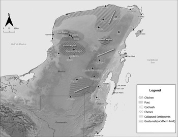
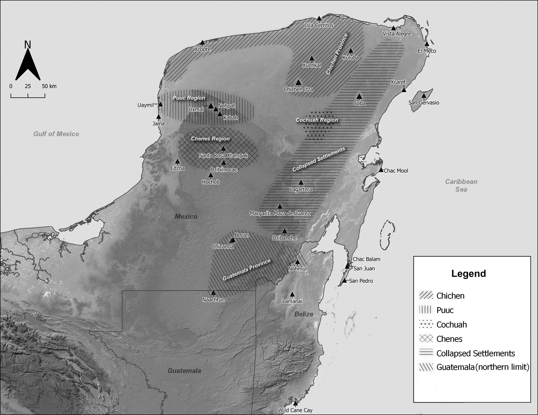
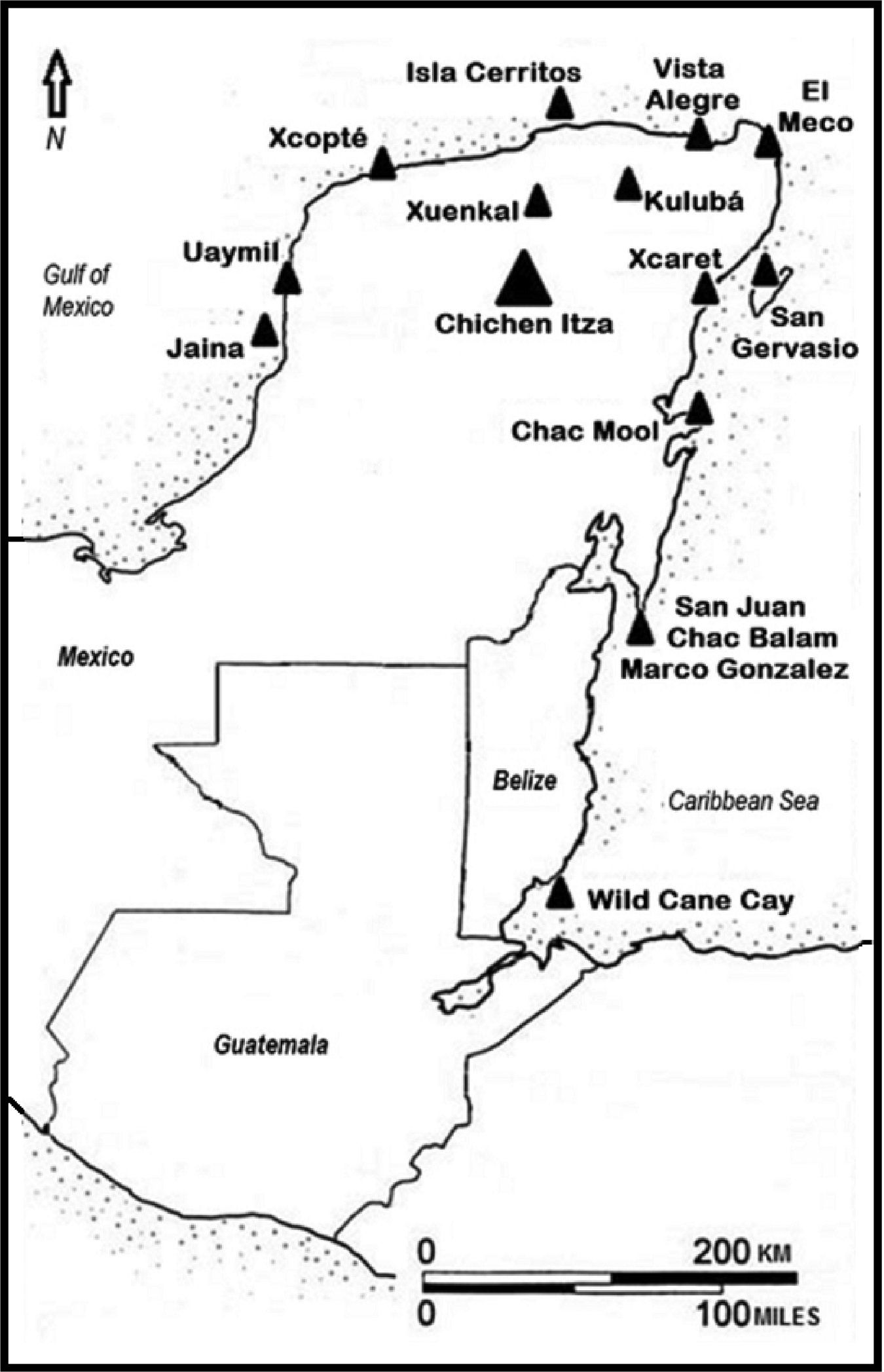
According to Garraty (Reference Garraty, Garraty and Stark2010:18), Hirth (Reference Hirth2020:321), and Oka and Kusimba (Reference Oka and Kusimba2008:366), several explanations should be included in the study of ancient economies, rather than favoring just one of them. With this approach, we can identify different sociopolitical scenarios as arenas where exchanges were carried out, not only in stable times, but also in times of crisis. Considering this perspective, archaeological data recovered in Chichen Itza and in several settlements located inland, as well as along the maritime coast of the Maya Lowlands, reveal that this settlement emerged as an important political unit during the Maya collapse—in other words, when a severe social, political, and economic crisis affected the entire Maya area (see Figure 1; Aimers Reference Aimers2007; Demarest et al. Reference Demarest, O'Mansky, Dunning, Beach, Laporte, Arroyo, Escobedo and Mejía2004, Reference Demarest, Victor, Andrieu, Torres, Okoshi, Chase, Nondédéo and Charlotte Arnauld2021; Okoshi et al. Reference Okoshi, Chase, Nondédéo and Arnauld2021).
Archaeological sites, regions and provinces mentioned in the text. Drawing by Joaquín Venegas de la Torre.
The proposal to associate a market exchange economy with Chichen Itza during its heyday in times of regional crisis is tempting; however, considering the context of social and political transformations in which this settlement found itself between the ninth and eleventh centuries, there is a possibility that other economic forms of exchange could have operated, such as tribute and centralized redistribution. These forms of exchange may have functioned regionally and were perhaps contemporary to the market exchange economy; however, the different areas and/or sites where they operated have yet to be identified with greater archaeological precision in the Maya Lowlands.
Therefore, this article argues that Chichen Itza could have functioned as a city and regional political-economic entity, due to its reliance on tribute and centralized redistribution economy rather than on a market exchange economy. To elaborate on this proposal, in the first section, the concept of market exchange and whether this type of exchange actually took place in any pre-Hispanic market, including Chichen Itza, is analyzed. Tribute and its possible role in Chichen Itza's economy is analyzed in the second section. The concept of centralized redistribution and its use in Chichen Itza during its heyday and in times of crisis is defined in the third section. The archaeological evidence at a regional level is analyzed in the fourth section, particularly considering coastal settlements that were used by Chichen Itza as its coastal maritime stations. Tribute collected in the interior of the lowlands was transported through these maritime stations, and when it reached this political unit in northern Yucatan, this tribute was redistributed internally in a centralized manner among members of the community.
MARKET EXCHANGE AND MARKETPLACES
In the study of the pre-Hispanic Maya economy, two concepts have emerged that go hand in hand: market exchange and marketplaces (see Masson et al. Reference Masson, Hare, Lope, Ojeda, Paris, Kohut, Russell and Alvarado2016:234). This section refers to both concepts.
Market exchange is defined as the process involving a set of economic transactions in which products or goods are exchanged at a socially agreed value, considering supply and demand. In market exchange, economic transactions are balanced and reciprocal and individuals congregate in pursuit of specific economic actions. In other words, market exchange occurs when intermediaries or mediators intervene to move goods from producers to consumers (Feinman and Garraty Reference Feinman and Garraty2010:169; Garraty Reference Garraty, Garraty and Stark2010:5–6; Hirth Reference Hirth2016:60–61, Reference Hirth2020:278).
Market exchange is a part of microeconomic studies and recognizes that individuals make economic choices that aim to maximize or optimize their utility or profit. Therefore, concepts and/or words, such as fully commercialized systems, market exchange—whether managed, monopolistic, or open-competitive—supply and demand, retail and wholesale of goods, maximization of opportunities, profit (surplus), commodities and their value or price determination, are widely used by those who study market exchange (see Braswell Reference Braswell, Garraty and Stark2010; Braswell and Glascock Reference Braswell, Glascock and Glascock2002; Hirth Reference Hirth1998, Reference Hirth2020; Plattner Reference Plattner and Plattner1989; Smith Reference Smith and Smith1976). Indeed, according to Polanyi (Reference Polanyi1944:45), market economy is an “economy directed by market prices and nothing but market prices.”
Carol Smith (Reference Smith and Smith1976) recognized that market exchange is complex and agents such as intermediaries and/or merchants actively participate or intervene in economic transactions between producers and consumers. In addition, Smith (Reference Smith and Smith1976, Table 1, Figure 1) identified the following three types of market exchange: administered, monopolistic, and competitive, and characterized each as follows. In administered market exchange, trade is partially commercialized and products are distributed by a solar central place system and “politics dominates commerce” (Smith Reference Smith and Smith1976:334, Table 1). In monopolistic market exchange the reverse is true—that is, trade dominates politics and is also partially commercialized, and product distribution follows the dendritic central place system (Smith Reference Smith and Smith1976:334, Table 1). Competitive market exchange is characterized by having a total level of trade, and product distribution is characterized by the central place interlocking system, which, in essence, are the centers or hubs of modern economic systems (Smith Reference Smith and Smith1976:356–367, Table 1). Regarding the features or elements that define competitive market exchange, Braswell (Reference Braswell, Garraty and Stark2010:132) pointed out that in this type of exchange, “market forces of supply and demand determine both the whole sale and retail value of goods.”
The concept of market exchange has been used at Chichen Itza to explain its economic development and functioning during its rise and apogee between the ninth and eleventh centuries. Braswell and Glascock (Reference Braswell, Glascock and Glascock2002, Reference Braswell, Glascock, Laporte, Arroyo and Mejía2007; see also Braswell Reference Braswell, Garraty and Stark2010) have proposed that, in the ninth century, when Chichen Itza was still undergoing its urbanization process, the economy of this pre-Hispanic community was characterized by “a solar central-place system and an administered market economy” (Braswell Reference Braswell, Garraty and Stark2010:137). This type of exchange is distinguished by having partially commercialized distribution systems—as reported in premodern colonial territories, developing states and empires—and markets and people have “great life-style differences” (Smith Reference Smith and Smith1976:338–345, Tables 1–2). Other features that characterize the solar central place system include: (1) the existence of urban centers located “in the middle of the tributary hinterlands” (Smith Reference Smith and Smith1976:319); (2) marketing that allows for the relationship between an urban center and rural settlements; (3) a complete lack of competition between large and medium-size centers; (4) no competition between large centers, so that “power and responsibility must be delegated exclusively at each level in a pyramidal chain of command” (Smith Reference Smith and Smith1976:319); (5) administrative centers that are monopolistic, since they control marketing, taking the location and frequency of economic transactions into account; and (6) producers who depend on monopolistic control of marketing and, therefore, specialize in “only simple handicrafts or farm goods that do not require much in the way of labor expenditure or full-time specialization” (Smith Reference Smith and Smith1976:319).
During the tenth century, the economy of Chichen Itza became “an important node in a trans-Mesoamerican interlocking central-place system” (Braswell and Glascock Reference Braswell, Glascock and Glascock2002:41); therefore, the economic system of this ancient city during its peak became “an open, competitive market,” fully commercialized and dominated by the forces of supply and demand, and the market or markets continued to function at Chichen Itza (Braswell and Glascock Reference Braswell, Glascock and Glascock2002:37). In the interlocking central place system, each market center is associated with several centers at both low and high levels, creating “a network with several levels, several links between levels, and hierarchically organized service to all places in the system” (Smith Reference Smith and Smith1976:320). Furthermore, (1) economic transactions are dominated by supply and demand, and fixed prices govern what is sold and what is bought; (2) products circulate to and from other regions or systems, allowing economic transactions at every level of each local system; (3) commercial exchange occurs in unbound regions where it can overlap; social stratification is complex; and (4) there is economic-social competition and people are “culturally homogeneous” (Smith Reference Smith and Smith1976, Table 2, 320).
Braswell and Glascock's (Reference Braswell, Glascock and Glascock2002, Reference Braswell, Glascock, Laporte, Arroyo and Mejía2007; see also Braswell Reference Braswell, Garraty and Stark2010) proposal on the differences in Chichen Itza's economic system between the ninth and tenth centuries is based mainly on their interpretation of the distribution of obsidian in Mesoamerica and its presence at Chichen Itza and Isla Cerritos. When Chichen Itza's economic system became “an open competitive market” in the tenth century, as proposed by Braswell (Reference Braswell, Garraty and Stark2010:137) and Braswell and Glascock (Reference Braswell, Glascock and Glascock2002:37, Reference Braswell, Glascock, Laporte, Arroyo and Mejía2007), the coastal ports of Isla Cerritos and Vista Alegre emerged as key elements in this interlocking central place system. Furthermore, Glover et al. (Reference Glover, Hruby, Rissolo, Ball, Glascock and Steven Shackley2018), using obsidian and ceramic survey data, argue that Vista Alegre, located on the northern coast of Yucatan, was a “specialized coastal trading center” (Glover et al. Reference Glover, Hruby, Rissolo, Ball, Glascock and Steven Shackley2018:490). Thus, Vista Alegre was part of the open and competitive market exchange dominated by Chichen Itza and was immersed in economic transactions regulated by wholesale and retail values of merchandise (as argued by Braswell Reference Braswell, Garraty and Stark2010 and Braswell and Glascock Reference Braswell, Glascock and Glascock2002, Reference Braswell, Glascock, Laporte, Arroyo and Mejía2007).
Undoubtedly, market exchange provides more open access to goods produced by different societies or social groups. This type of exchange can have an organized space in which the producers of the goods gather at specific places and dates to engage in exchange (Feinman and Garraty Reference Feinman and Garraty2010; Garraty Reference Garraty, Garraty and Stark2010; Hirth Reference Hirth1998). The physical expression of this organized space is a marketplace that usually occupies specific areas, either along streets, as in Apollonia-Arsuf in Israel (Roll and Ayalon Reference Roll and Ayalon1987), and/or in plazas and places near temples, as reported in the first half of the sixteenth century in Tlaxcala (Cortés Reference Cortés1963) and Tlatelolco (Benavente Reference Benavente1914; Cortés Reference Cortés1963; Díaz del Castillo Reference Díaz del Castillo1966) in central Mexico. In the Maya area, extensive literature on marketplaces exclusively favors their existence in the plazas of numerous archaeological sites dated to the Classic period (see, for example, Anaya Hernández et al. Reference Anaya Hernández, Reese-Taylor, Walker and Dunning2021; Cap Reference Cap and King2015, Reference Cap2019, Reference Cap, Masson, Freidel and Demarest2020, Reference Cap2021; Cap et al. Reference Cap, Yaeger and Kathryn Brown2017; Chase and Chase Reference Chase and Chase2014, Reference Chase, Chase, Masson, Freidel and Demarest2020; Dahlin et al. Reference Dahlin, Jensen, Terry, Wright and Beach2007; Hutson and Dahlin Reference Hutson, Dahlin and Hutson2017; Hutson et al. Reference Hutson, Terry, Dahlin and Hutson2017; King Reference King and King2015, Reference King, Masson, Freidel and Demarest2020, Reference King2021; King and Shaw Reference King, Shaw and King2015; Masson and Freidel Reference Masson and Freidel2012, Reference Masson, Freidel, Hirth and Pillsbury2013; Shaw Reference Shaw2012; Shaw and King Reference Shaw, King and King2015). However, Becker (Reference Becker and King2015:93) has noted that “not every open area need have served as a market space,” and suggested that the causeway surface may have provided sufficient space for display merchandise (Becker Reference Becker and King2015:94; see also Chase et al. Reference Chase, Chase, Terry, Horlacher, Chase and King2015:240).
The archaeological finding of a marketplace in any Maya settlement is still nonexistent, although authors such as King and Shaw (Reference King, Shaw and King2015:15) suggest combining open spaces such as plazas with architectural features, deposits associated with macro- and micro-artifacts, and chemical indicators in soils to produce “the most convincing evidence” of their existence. If this combination or amalgamation of elements does not exist, none of them alone are solid and convincing evidence that marketplaces existed in the Maya area (King and Shaw Reference King, Shaw and King2015:15; see also comments by Houston and Inomata Reference Houston and Inomata2009:251–252, and Potter and King Reference Potter, King, Ehrenreich, Crumley and Levy1995:23–24).
In addition to archaeological evidence, the suggestion that marketplaces existed in the Maya area is supported by historical analogies from central Mexico, which assume that plazas at Maya sites hosted marketplaces, as was the case at Tlatelolco. It should be noted that the rapid founding of marketplaces by the Spanish conquerors before 1550 in the Maya area has not been seriously considered by proponents of those locations where exchange took place. For example, between 1537 and 1539 in Verapaz (Guatemala), and in 1541 in Tabasco (Mexico), the Spanish founded marketplaces, as reported by Bartolomé de las Casas (Reference Casas1967:bk III, p. 514) and Scholes and Roys (Reference Scholes and Roys1968:31–32), respectively. Bishop Landa (Reference Landa1959:39–40, 57), after his arrival in Yucatan in 1549, reported the existence of marketplaces in this region and there is a possibility that he referred to markets founded in Mérida, Valladolid, and Campeche by Spaniards in the early 1540s, several years prior to his arrival in Yucatan.
It is also worth mentioning that the plazas of different Maya sites could have been places where barter exchange took place since the Preclassic period, and, perhaps, in the second half of the fifteenth century or the beginning of the sixteenth, the plazas themselves became marketplaces. If this were the case, the Maya may also have belatedly given the meaning of market to those large open spaces and the word plaza in the Maya language became a polysemic concept on the eve of the Spanish conquest (see Hopkins Reference Hopkins2013; Speal Reference Speal2014).
The market exchange economy proposed for Chichen Itza has also been associated with the supposed existence of a marketplace in a plaza at this site, and Masson and Freidel (Reference Masson and Freidel2012, Table 1) argue that the wide space delimited by the Plaza of the Thousand Columns served that function. It should be noted, however, that the surface of the Plaza of the Thousand Columns and other plazas at Chichen Itza have never been systematically excavated to look for the remains of marketplaces. In addition, the physical remains lying in the vast space of the Plaza of the Thousand Columns come from façades and/or structures dismantled after the Classic period that represented Chichen Itza's apogee. These remains have also been interpreted as: (a) very rudimentary vestiges of dance platforms, dating to the Postclassic period; (b) bases or foundations of habitational structures dated to the first half of the sixteenth century; (c) archaeological features associated with human and/or animal sacrifices prior to Spanish contact (Ruppert Reference Ruppert1925:270). Therefore, the proposal that the Plaza of the Thousand Columns served as a marketplace is—for now—highly speculative and questionable.
TRIBUTE
According to Smith (Reference Smith2004:84), tribute can be defined as “wealth transfers between states.” This economic transfer has political implications, since it occurs when a state, city, or region pays with goods and/or services to a state or empire that exercises political and/or military control over all or some of these three entities. In addition, the dominant state or empire necessarily demands, and regularly obtains, those goods and/or services. In a purely economic sense, tribute is a one-way exchange of services and goods that is politically controlled (Berdan et al. Reference Berdan, Masson, Gasco, Smith, Smith and Berdan2003:104; Gasco and Voorhies Reference Gasco, Voorhies and Voorhies1989:48; McAnany Reference McAnany2010:277–278).
The ways in which a city, state, or empire obtains tribute are varied. For example, when a realm or city was conquered militarily, the dominant realm or city exacted “tribute from subjugated peoples, and these demands accentuated the vertical movements of goods and services already entrenched in the hierarchical order of individual city-states themselves” (Berdan et al. Reference Berdan, Masson, Gasco, Smith, Smith and Berdan2003:104). In other cases, tribute would be a diplomatic arrangement—for example, when one ruler regularly pays another to be subjugated “and in return for protection from invasion by the superior power and/or third parties” (Gasco and Voorhies Reference Gasco, Voorhies and Voorhies1989:48; see also McAnany Reference McAnany2010:277–278). Hirth (Reference Hirth2020:177) recognized that tribute could be obtained as voluntary gifts; when individuals were made slaves; by the confiscation and redistribution of land; by the occupation of territories by new settlers; by the “expropriation of cottage industries”; by the creation of new fines, licences, and fees; and by the payment of new taxes on trade, property, and land. Any of these different ways of obtaining tribute always had a particular purpose, which was to finance “expensive state enterprises and lavish standards of living for the elite” (Berdan et al. Reference Berdan, Masson, Gasco, Smith, Smith and Berdan2003:104).
Smith (Reference Smith2004:84) pointed out that, in Mesoamerican archaeological studies, when the word tribute is used, it refers both to taxes and to tribute itself. Furthermore, Smith (Reference Smith2004:84) differentiated between tribute as an economic transaction where wealth relocates between states, and taxes as “obligatory transfers from individuals to the state,” and acknowledged that these two terms “can be difficult to distinguish archaeologically.” Following Smith's caution to differentiate materially between tribute and tax, it may be archaeologically impossible to distinguish between them when studying staple and wealth finance systems.
According to D'Altroy and Earle (Reference D'Altroy and Earle1985), in archaic states, the payment of tribute implied the financing of social activities through the systems of staple and wealth finance. The former consisted of compulsory payment to the state of “subsistence goods such as grains, livestock, and clothing,” while the latter involved “the manufacture and procurement of special products (valuables, primitive money, and currency…) that are used as means of payment” (D'Altroy and Earle Reference D'Altroy and Earle1985:188). Hirth (Reference Hirth2020:112, see also 375) points out that “staple finance systems” aided the consumption of goods in small agricultural societies, since they did not require their mobilization or transport over long distances. However, as these agricultural societies grew larger and became more complex, the wealth finance system emerged and was used in “high-value commodities or prestige goods to fund formal institutions and elite-sponsored activities” (Hirth Reference Hirth2020:113, 376; see also McAnany Reference McAnany2010:270–272).
Citizens paid taxes to the state and these taxes could become tribute when one state used them to pay another dominant state or empire. On the other hand, when a city, region, or state paid tribute to a dominant political unit, this tribute could end up in two totally different economic arenas or domains. These arenas or domains were the market exchange economy and the centralized redistribution economy. The circulation of tribute in a market exchange economy has been documented extensively in Mesoamerica during Aztec times (see, for example, Berdan et al. Reference Berdan, Masson, Gasco, Smith, Smith and Berdan2003; Gasco and Voorhies Reference Gasco, Voorhies and Voorhies1989; Gutiérrez Reference Gutiérrez, Hirth and Pillsbury2013; Hirth Reference Hirth2016, Reference Hirth2020). The Aztecs controlled an extensive territory in which the wealth finance system allowed certain types of goods (cacao, textiles) to function as currency; a sector of the population—the elite—was able to accumulate nonperishable goods; and independent and attached artisans were able to convert tributary raw materials into goods and/or commodities with high prestige value (Hirth Reference Hirth2020:113, 124, 184). In fact, Masson et al. (Reference Masson, Hare, Lope, Ojeda, Paris, Kohut, Russell and Alvarado2016:234) assert that market exchange and “tribute systems were complementary to one another,” and, in this same tenor, Martin (Reference Martin2020:341, see also 339–340, 379) recognized that “whatever scale a Classic Maya tribute economy attained it must be considered within a more diverse mix of economic activities and obligations.”
Tribute circulating in the arena of centralized redistribution flowed mandatorily to the center of a political structure, such as the chiefdom, kingdom, or state, and, from this center, was redistributed in three different ways: (1) at banquets and/or feasts; (2) at work festivals; and (3) in social arenas or spaces, where it was needed “to consolidate the power structure” by means of prestige goods (Narotzqui Reference Narotzqui1997:48; see also Hirth Reference Hirth2020:134). Hirth (Reference Hirth2020:134, 140, 143; see also Hirth and Pillsbury Reference Hirth, Pillsbury, Hirth and Pillsbury2013a:17; Smith Reference Smith2004:79; Stark and Garraty Reference Stark, Garraty, Garraty and Stark2010:46–47) points out that centralized redistribution is a form of economic exchange that can operate under particular or specific circumstances, as occurred in the Inka economy. For Hirth (Reference Hirth2020:145):
the Inka institutional economy is an excellent example of how the direct production of staple goods together with the production and circulation of wealth goods provided the basis for a state economy when it was combined with careful planning and organization.
Apparently, during Chichen Itza's heyday, between the tenth and eleventh centuries, a centralized redistribution economy may have functioned, considering that careful planning and organization could have provided the conditions for the production and circulation of staple and wealth goods. In the functioning of a centralized redistribution economy, tribute may have been the economic, political, and social “engine” that helped Chichen Itza in the late Classic period to function as a powerful state, just as the transformation or transition to the Postclassic period was occurring in the Maya Lowlands (Demarest et al. Reference Demarest, Victor, Andrieu, Torres, Okoshi, Chase, Nondédéo and Charlotte Arnauld2021; Okoshi et al. Reference Okoshi, Chase, Nondédéo and Arnauld2021). Data recorded in historical sources from the sixteenth century mention the role of tribute in that ancient city, and the remains of a mural found at the Temple of the Warriors seem to corroborate it.
For example, the Relación de Izamal y Santa María, states that:
at one time all this land was under the dominion of one lord, when the ancient city of Chichen Itza [Chichén Yza] was at its prime. To him were tributary all the lords of this province; and even from outside the province, from México [Mejico], Guatemala [Guatimala], and Chiapa (Roys Reference Roys, Pollock, Roys, Proskouriakoff and Ledyard Smith1962:52; Garza Reference Garza1983:vol. I, p. 305; see also Relaciones de Citilcum y Cabiche, Kizil y Sitilpech, Tekantó y Tepaká, Dzidzantun, Dzudzal, Chalamté y Tekal, in de la Garza Reference Garza1983:vol. I, pp. 182, 200, 216, 216, 411, 426, 440).
Morris (Reference Morris, Morris, Charlot and Morris1931:490; see also Morris et al. Reference Morris, Charlot and Morris1931:vol. II, Figure 154b) noticed that some of the themes painted on stones found at Area 25 on the summit of the Temple of the Warriors bear “a striking resemblance to the tribute rolls, as they appear in the Mexican Codices.” Morris (Reference Morris, Morris, Charlot and Morris1931:409) identified a bowl filled with incense or vegetable material, two lengths of cloth “elaborately embroidered in black,” and a back crest with green feathers.
Unfortunately, neither the historical sources nor the mural painting specify the products that the rulers of the provinces of Chichen Itza, Chiapas, Guatemala, and Mexico paid tribute for, although archaeological evidence and historical documents suggest the following items: salt, textiles, Spondylus shells, and slaves (brought from Chichen Itza Province?), jadeite objects, obsidian blades, Tohil Plumbate pottery, cacao, and quetzal feathers (originating from Guatemala Province?), textiles and cacao? (paid for by Chiapas Province?), obsidian blades (paid for by the provinces of Guatemala and Mexico? see also McAnany Reference McAnany2010:286–288). In addition, we do not know the frequency of tribute payment(s), nor the precise location and extent of the various provinces that paid tribute to Chichen Itza, although Manahan et al. (Reference Manahan, Ardren and Olvera2012:346–347, 359–361; see below) have suggested that the site of Xuenkal, located 50 km north of Chichen Itza, paid tribute to this political unit in the form of projectile points made of flint, decorative shell objects, and textiles.
Material evidence recovered by archaeological excavations and data provided by sixteenth-century historical sources suggest that, in the consolidation of Chichen Itza's power structure, prestige goods collected as tribute were redistributed by individuals close to power (rulers, administrators, warriors) and/or by those who enjoyed a highly privileged hierarchical position (the elite, high leaders or chiefs in charge of important sectors of Chichen Itza's society). Other internal forms in which tribute might have been redistributed at Chichen Itza may have included religious and/or work festivals, banquets and/or feasts, and gifts, although they have yet to be identified archaeologically.
During its expansion process between the tenth and eleventh centuries, Chichen Itza was a state that seems to have used its political power and its warriors in military battles with an apparent purpose: to conquer and dominate a region, city, or state in order to obtain tribute in times of social, political, and economic crisis caused by the Maya collapse. The silent rhetoric carved in stones and painted on murals at Chichen Itza clearly reveals their ostentatious military power (Baudez and Latsanopoulos Reference Baudez and Latsanopoulos2010; Coggins and Ladd Reference Coggins, Ladd and Coggins1992; Miller Reference Miller and Hammond1977; Olmo Reference Olmo Albarrán and Cobos2016; Ringle Reference Ringle2009; Ringle and Bey III Reference Ringle, Bey, Fash and Luján2009). In addition, based on his interpretation of the murals adorning the internal walls of the upper building of the Temple of the Jaguars (Structure 2D1), Miller (Reference Miller and Hammond1977:218) proposed that these were battle scenes in southern Oaxaca, and possibly the Peten area of northern Guatemala; however, Robles Castellanos and Andrews (Reference Robles Castellanos, Andrews, Sabloff and Andrews1986:84) proposed that the battle scenes occurred in the Puuc region of western Yucatan. It is worth noting that in this article (see below) it is proposed that the northern boundary of Guatemala Province may have included the southern part of Campeche and Quintana Roo and northwestern Belize; however, we do not know against which city, state, or region located in Guatemala Province Chichen Itza may have used its military force, and we do not know the battlefields where its warriors confronted rival warriors to secure the obligatory payment of tribute.
CENTRALIZED REDISTRIBUTION
Scholars such as Renfrew (Reference Renfrew, Earle and Ericson1977:88) and Stark and Garraty (Reference Stark, Garraty, Garraty and Stark2010:34, 51) point out that the material footprints left by a market exchange economy and centralized redistribution are spatially similar or identical. Therefore, it is precisely these material footprints being so similar or identical that invites a proposal for an alternative explanation in the interpretation of Chichen Itza's economy during its apogee.
Centralized redistribution exchange consists of “appropriational movements toward a center and out again” (Polanyi et al. Reference Polanyi, Arensburg and Pearson1957:250; see also Halstead Reference Halstead2011:233; Nakassis et al. Reference Nakassis, Parkinson and Galaty2011:178–179, 182; Narotzqui Reference Narotzqui1997:48; Renfrew Reference Renfrew, Sabloff and Lamberg-Karlovsky1975:43; Temin Reference Temin2013:6). This type of exchange exhibits the following six characteristics.
First, in centralized redistribution there is no commercialization, no retail and/or wholesale of goods, no marketplaces, no independent merchants, no money, no determination of prices, no surplus, and no institutions associated with commercial exchange (Hirth and Pillsbury Reference Hirth, Pillsbury, Hirth and Pillsbury2013a:16; Smith Reference Smith and Smith1976:314; Smith Reference Smith2004:79; see also La Lone's Reference La Lone, Ericson and Earle1982 definition of “command economy”).
Second, the state orders, commands, and directs the economy through government institutions, which managed wealth goods in different ways. These goods show the opulence and wealth of rulers and/or members of the elite who obtain them to consume them (D'Altroy and Earle Reference D'Altroy and Earle1985; Earle Reference Earle2011; Hirth and Pillsbury Reference Hirth and Pillsbury2013b; Stark and Garraty Reference Stark, Garraty, Garraty and Stark2010).
Third, wealth goods, when consumed, are intended to increase the status of the elite, rulers, and/or central political authority (Bayman Reference Bayman1995:55; Stanish Reference Stanish, Garraty and Stark2010:194). Therefore, objects that have been socially designated as prestige goods or high-value commodities are redistributed in order to enhance political power (Aprile Reference Aprile2013:435) or “consolidate the power structure” (Narotzqui Reference Narotzqui1997:48), “cement social relationships” (Oka and Kusimba 2008:344), such as friendship, solidarity, and godfatherhood, and/or “control the social performance and fix people's position in the social hierarchy and the political landscape” (Voutsaki Reference Voutsaki, Voutsaki and Killen2001:213). In light of this reasoning, Hodder (Reference Hodder, Ericson and Earle1982:204; see also Stanish Reference Stanish, Garraty and Stark2010:194) noted that “economic man produces wealth, not to obtain food, but to give gifts that will obligate others to him and increase his social power.”
Fourth, rulers and members of the elite do not operate or function as intermediaries in the redistribution of wealth goods among members of the different domestic units that make up the settlement or community (Bayman Reference Bayman1995:40; Stark and Garraty Reference Stark, Garraty, Garraty and Stark2010:36). The redistribution of wealth goods is carried out directly by rulers, members of the elite, and/or central political authorities with other members of the community through clientage and/or social ties (Hirth Reference Hirth1998:455; Stanish Reference Stanish, Garraty and Stark2010:194; Stark and Garraty Reference Stark, Garraty, Garraty and Stark2010:48).
Fifth, centralized redistribution is carried out from elite residential units such as palaces. In addition, these residential units are part of an intricate local (intersite) as well as regional (intrasite) distribution network (see Aprile Reference Aprile2013; Halstead Reference Halstead2011:233; Hirth and Pillsbury Reference Hirth, Pillsbury, Hirth and Pillsbury2013a; Hodder Reference Hodder, Ericson and Earle1982; Stark and Garraty Reference Stark, Garraty, Garraty and Stark2010; Voutsaki Reference Voutsaki, Voutsaki and Killen2001). According to Smith (Reference Smith and Smith1976:312), “the special economic status of the elite is seen to depend upon their control of distribution and exchange rather than production.”
Sixth, a state that has as its economic system centralized redistribution uses it to support and satisfy political authorities or members of the elite in their particular political, military, ritual, and economic projects (Stark and Garraty Reference Stark, Garraty, Garraty and Stark2010:46). Therefore, in centralized redistribution the state manages and directs the workforce—for example, for purposes of building infrastructure such as roads, agricultural works, the construction of huge and elaborate architectural complexes and palaces, and the construction and/or administrative management of seaports.
Centralized redistribution was mentioned in the Maya archaeological literature four decades ago (see Henderson Reference Henderson1981:152); however, with the exception of Aoyama's (Reference Aoyama1999) work in the Copán Valley and La Entrada in Honduras, it has not been used to analyze the economy at the end of the Classic or during the Postclassic period. In fact, Masson and Freidel (Reference Masson and Freidel2012:457) consider that the concept of elite redistribution “has been dismissed based on the scale of the undertaking.” Contrary to Masson and Freidel's (Reference Masson and Freidel2012) statement, I consider that centralized redistribution offers an alternative for analyzing the existence of wealth goods paid for as tribute to Chichen Itza at a time when economic, social, and political transformations occurred between the end of the Classic and beginning of the Postclassic period.
The aforementioned centralized redistribution exchange might have been used to support the fulfilment of different projects ordered by both political authorities and/or elite members in their efforts to obtain wealth goods (Stark and Garraty Reference Stark, Garraty, Garraty and Stark2010:46). Hirth and Pillsbury (Reference Hirth, Pillsbury, Hirth and Pillsbury2013a:17), however, point out that centralized redistribution is an “extremely costly form of distribution that is difficult to maintain except under special circumstances or for a narrow range of goods.” For instance, the Inka economy seems to have functioned according to centralized redistribution exchange in which wealth goods were distributed among state administrators on special occasions, such as religious festivities (Hirth Reference Hirth2020:143). These wealth goods, which included Spondylus shells, textiles, and valuable metal objects, were part of a strategy utilized by the Inka state to balance and repay for services rendered by persons whose social hierarchies were different (see also Hirth Reference Hirth2020:134). The Inka state exchanged wealth goods as gifts and/or reciprocal payments with those individuals.
Another example of redistribution by the state has been documented in Rome between the first and third centuries a.d. and is known as Annona. During the peak of Imperial Rome, Annona
was the imperial system that guaranteed the stable supply and distribution [for free or very low price] of essential products to Roman citizens officially enrolled as its beneficiaries and to troops stationed in different parts of the empire (Machado Reference Machado2018:1; see also Temin Reference Temin2013:17).
Initially, Annona was used for the free distribution of wheat; however, over time, other commodities, such as wine, pork, and olive oil, were added to the Annona system (Machado Reference Machado2018:1). According to Temin (Reference Temin2013:33), Annona represented the active participation of the Roman state in times of wheat shortages and, by doing so, prevented price escalation. It should be noted that Annona functioned in times when the Roman economy operated as market exchange (Temin Reference Temin2013).
What does the centralized redistribution of goods in the Inka economy and the Roman Empire suggest? First, rulers, administrators, and members of high hierarchical position ensured the distribution of staple (Rome) and/or wealth goods (Inka) in both difficult and prosperous times. Thus, a state may employ redistribution as an economic response according to very specific situations or circumstances, as Hirth (Reference Hirth2020:134) and Hirth and Pillsbury (Reference Hirth, Pillsbury, Hirth and Pillsbury2013a:17) have recognized. Second, the redistribution of high-value commodities or prestige goods allowed members of a high social hierarchy to consolidate the power structure by increasing their power through gifts and/or payments for reciprocal services (Aprile Reference Aprile2013:435; Hodder Reference Hodder, Ericson and Earle1982:204; Narotzqui Reference Narotzqui1997:48; Oka and Kusimba Reference Oka and Kusimba2008:344; Stanish Reference Stanish, Garraty and Stark2010:194). Third, the elite play an active, as well as decisive, role in controlling the distribution and exchange of high-value commodities (Smith Reference Smith and Smith1976:312). Fourth, rulers and members of the elite may have embarked on very specific projects to benefit economically. These projects probably included the extension of territory using military force, political control of regions, cities, or states to obtain tribute, the establishment of political alliances in key sites and/or regions, the undertaking of large projects involving a huge amount of labor for the construction of a large infrastructure, and so on.
When the archaeological data recovered at Chichen Itza and numerous seaports located in the Gulf of Mexico and Caribbean Sea are analyzed using tribute and exchange by centralized redistribution, these data reveal three things. First, the evidence shows that high-value commodities were—apparently—paid for as tribute to Chichen Itza. Second, prestige goods found at several coastal sites mirror the same types of produces that Chichen Itza's elite and rulers obtained to consume them. Third, alliances, reciprocity, payment of services and gifts must have dominated the relationships between local inhabitants of the ports and servants in Chichen Itza residing in those coastal settlements. Considering these three aspects, this article analyzes the role of the seaports that were used by Chichen Itza in the transportation of high-value commodities at the end of the Terminal Classic period.
CHICHEN ITZA AND ITS MARITIME PORTS
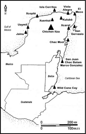
Archaeological evidence suggests that, if a centralized redistribution economy functioned at Chichen Itza during its heyday, tribute may have been the economic force that mobilized it. Furthermore, transportation of this tribute must have been carried out through coastal-maritime settlements that Chichen Itza may have controlled militarily and/or politically, or probably made alliances with key coastal settlements that guaranteed the arrival of tribute paid products (Figure 2).
Chichen Itza and its 13 maritime stations. Drawing by the author.
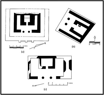
The numerous coastal settlements whose archaeological evidence suggests strong links with Chichen Itza reveal three things: first, the establishment by Chichen Itza of Isla Cerritos—a coastal settlement located 90 km north of Chichen Itza—as a seaport in the Gulf of Mexico for its exclusive use; second, the presence of structures consisting of a temple, altar, and colonnade and/or pillars, very similar to the architectural design found in the Great Terrace at Chichen Itza. The presence of this architectural design is clearly visible in the ports of Xcopté and Uaymil, located to the west of Isla Cerritos, and their construction suggests the control of these two ports by individuals closely affiliated with Chichen Itza. These individuals may have migrated and occupied these two maritime stations and coexisted with Xcopté and Uaymil's local residents. Finally, coastal settlements located east of Yucatan (Vista Alegre, El Meco, San Gervasio, Xcaret, Chac Mool) and the Belize coast (San Juan, Chac Balam, Marco Gonzalez), do not have the spatial arrangement consisting of a temple, altar, and colonnade and/or pillars suggesting political alliances between local residents of these ports and the representatives who served Chichen Itza.
Archaeological evidence also indicates that during Chichen Itza's apogee, this political unit did not use the Maya lowland inland routes; on the contrary, the maritime coastline washed by the waters of the Gulf of Mexico and the Caribbean Sea was the main avenue along which its canoes and those in charge of transporting wealth goods circulated until they reached Isla Cerritos. The mural that once adorned one of the walls of the upper part of the Temple of the Warriors is clear testimony of why maritime stations closely associated with Chichen Itza were very important for this political unit (Cobos Reference Cobos, Cobos and Souza2011; Morris Reference Morris, Morris, Charlot and Morris1931:424, Illustration 159).
The main characteristics shared by maritime stations closely associated with Chichen Itza include the following. First, they functioned as logistic support sites in the transportation or movement of wealth goods required for consumption at Chichen Itza. This logistic support might have provided for people in charge of rowing to rest or layover at different maritime stations, along with support for those individuals responsible for taking care and ensuring the safe arrival of their precious load at Chichen Itza via Isla Cerritos. Apparently, the cargo transported in canoes was neither lowered nor stored in the maritime stations; therefore, storage structures or storage areas may have not existed in these coastal settlements. Horizontal excavations carried out in several structures in Isla Cerritos, as well as this site's morphology, have not revealed constructions that were used to store a large number of high-value commodities (Clark Reference Clark2015; Cobos Reference Cobos, de Guevara, Budar and Lunagómez2012a, Reference Cobos and Barrios2020). The absence of storage facilities in Isla Cerritos could suggest that a limited array of wealth goods was obtained as tribute by Chichen Itza; however, this reduced selection of wealth goods was greatly valued by Chichen Itza's high hierarchical members. Perhaps, some of those wealth goods obtained as tribute included textiles, cacao, Spondylus shells, quetzal feathers, and jadeite objects, which “are written or imaged repeatedly in Classic Maya sources” (McAnany Reference McAnany2010:286; see also Tokovinine and Beliaev Reference Tokovinine, Beliaev, Hirth and Pillsbury2013:175–178).
Second, maritime stations were small settlements located both on the coast and on offshore islands. The maximum length of these specialized coastal settlements did not exceed 300 m, as is the case of Isla Cerritos, Uaymil, Xcopté, El Meco, Chac Mool, San Juan, Chac Balam, and Marco Gonzalez. Regarding Vista Alegre, Xcaret, and San Gervasio, the settlement that housed the Terminal Classic period maritime stations in each of these three coastal sites is extensively covered by Postclassic period constructions. It should be noted that the architectural and ceramic information reported by horizontal and vertical excavations carried out in Vista Alegre, Xcaret, and San Gervasio suggests that Terminal Classic period settlement associated with these three maritime stations did not exceed 300 m in length. In the case of Wild Cane Cay, this coastal settlement is covered by more than 1 m of water today and, although the archaeological materials found clearly relate this site to Chichen Itza, the total extension of the site is unknown. In reference to Jaina, located in northern Campeche, evidence suggests that this island functioned as a maritime station during the tenth and eleventh centuries, and Late Classic period (a.d. 600–800/850) buildings associated with the heyday of Jaina were reused by people related to Chichen Itza (Piña Chán Reference Piña Chán1968; Ruz Lhuillier Reference Ruz Lhuillier1969).
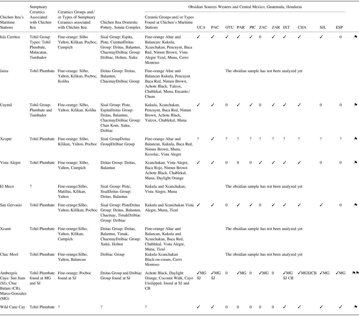
Third, according to Hammond (Reference Hammond, Hester and Hammond1976:73; see also Andrews Reference Andrews, Harrison and Clancy1990:165–166), maritime stations are “unexpectedly prolific in artifact material, with a larger proportion of exotic goods than a similar small fishing settlement would be able to acquire.” The prolific presence of wealth goods in maritime stations is strictly linked to the specialized role for which they were used (Table 1). For instance, the specialized function of San Juan, Marco Gonzalez, and Chac Balam suggested to Guderjan (Reference Guderjan1995a:147; see also Driver Reference Driver, Guderjan and Garber1995; Guderjan Reference Guderjan, Guderjan and Garber1995b; Guderjan et al. Reference Guderjan, Garber, Smith, Stross, Michel and Asaro1989) a change in the “dynamics of the trade system” during the tenth century. This change involved not only the active participation of those three coastal settlements in the north–south maritime route having Chichen Itza as one of its most distinctive participants, but also their interaction with central and northern Belizean settlements such as Lamanai (Graham Reference Graham, Rice and Sharer1987, Reference Graham2004; Pendergast Reference Pendergast1981) and Nohmul (Hammond Reference Hammond1974, Reference Hammond1983). A review of the evidence follows below.
Ceramic and obsidian materials found at different maritime stations.

Obsidian sources: UCA (Ucareo), PAC (Pachuca), OTU (Otumba), PAR (Paredón), PIC (Pico de Orizaba), ZAC (Zacualtipán), ZAR (Zaragoza), IXT (Ixtepeque), CHA (Chayal), SJL (San Martín Jilotepeque), ESP (La Esperanza).
Data obtained from the following sources: Isla Cerritos (Andrews et al. Reference Andrews, Asaro, Michels, Stross and Rivero1989; Braswell and Glascock Reference Braswell, Glascock and Glascock2002), Jaina (Ball Reference Ball1978; Benavides et al. Reference Benavides Castillo, Jiménez, Peniche, Aguirre, Ancona, Sauri and Euán2003, Reference Benavides Castillo, Jiménez, Daneels, Ancona, Sauri and Aguirre2005), Uaymil (Braswell and Glascock Reference Braswell, Glascock, Laporte, Arroyo and Mejía2007; Maury Tello Reference Maury Tello2017), Xcopté (Ball Reference Ball1978; Robles Castellanos and Andrews Reference Robles Castellanos and Andrews2003; Robles Castellanos and Ceballos Gallareta Reference Robles Castellanos and Gallareta2003), Vista Alegre (Glover et al. Reference Glover, Hruby, Rissolo, Ball, Glascock and Steven Shackley2018), El Meco (Robles Castellanos Reference Robles Castellanos, Andrews and Castellanos1986), San Gervasio (Braswell and Glascock Reference Braswell, Glascock, Laporte, Arroyo and Mejía2007; Peraza Lope Reference Peraza Lope1993, Reference Peraza Lope, Shaw and Mathews2005), Xcaret (Novelo Osorno Reference Novelo Osorno2005; Ochoa Rodríguez Reference Ochoa Rodríguez2004), Chac Mool (Núñez Enríquez Reference Núñez Enríquez and Cobos2004), Ambergris Caye (Graham Reference Graham, McKillop and Healy1989; Guderjan Reference Guderjan, Guderjan and Garber1995b, Reference Guderjan, Guderjan and Garber1995c; Guderjan and Garber Reference Guderjan, Garber, Guderjan and Garber1995; Guderjan et al. Reference Guderjan, Garber, Smith, Stross, Michel and Asaro1989; Valdez et al. Reference Valdez, Sullivan, Guderjan, Guderjan and Garber1995), Wild Cane Cay (Kidder Reference Kidder1954; McKillop Reference McKillop, Guderjan and Garber1995, Reference McKillop1996, Reference McKillop2005, Reference McKillop and Walker2016).
Isla Cerritos, Land Waystations, and the Terrestrial Corridor Connecting with Chichen Itza
Isla Cerritos was a port founded by Chichen Itza in the northern coast of Yucatan. An intensive program of mapping, as well as horizontal and vertical excavations, conducted during the years 1984–1985, 2006–2007, and 2010, revealed that during the tenth and eleventh centuries, this island was transformed from a small coastal site to a settlement with 32 structures distributed in three areas (Andrews et al. Reference Andrews, Negrón, Castellanos, Palma and Rivero1988; Clark Reference Clark2015; Cobos Reference Cobos, de Guevara, Budar and Lunagómez2012a, Reference Cobos and Barrios2020; Gallareta Negrón et al. Reference Gallareta Negrón, Andrews, Castellanos, Palma and Rivero1989; Robles Castellanos Reference Robles Castellanos, Rice and Sharer1987; Figures 3–5). The first area is located in the northwestern part of Isla Cerritos; Structures 1–7 were built in this sector and may have functioned as ceremonial and/or administrative buildings. For instance, Structure 1 is a temple, Structures 2 and 5 are long, rectangular buildings, whose internal space houses pillars; Structure 7 is an altar. With the exceptions of Structures 12–13 and 26–29, Structures 8–32 occupy the second area that extends toward the west, central, north, and east sectors of Isla Cerritos. Several of these structures probably had a domestic function. The third area is located on the southern side of the island, which houses a large open space and Platforms 12–13 and 26–29. These constructions may have been associated with landing activities of individuals who transported wealth goods. In fact, the southern side of the island faces a harbor wall, 330 m long, built 80 m from the southern shore, as well as an area that might have served as a calm harbor for pre-Hispanic canoes to unload their cargo (Andrews et al. Reference Andrews, Negrón, Castellanos, Palma and Rivero1988; Cobos Reference Cobos, de Guevara, Budar and Lunagómez2012a, Reference Cobos and Barrios2020; Gallareta Negrón et al. Reference Gallareta Negrón, Andrews, Castellanos, Palma and Rivero1989).
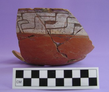
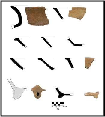
Isla Cerritos: Fine-orange Silho. Courtesy of the Isla Cerritos Archaeological Project.

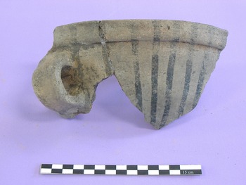
Isla Cerritos: Fine-orange, Pocboc Gouged-incised. Courtesy of the Isla Cerritos Archaeological Project.

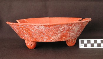
Isla Cerritos: Xcanchakan Black-on-cream. Courtesy of the Isla Cerritos Archaeological Project.

Once Isla Cerritos was reached, professional loaders—such as those depicted in the Temple of the Warriors mural (see Morris Reference Morris, Morris, Charlot and Morris1931:Illustration 159)—were in charge of transporting 90 km overland the wealth goods that rulers, administrative and political authorities, and members of the elite enjoyed at Chichen Itza, seeking to enhance their social, political, and economic status. Apparently, Chichen Itza established a land route to the coast of the Gulf of Mexico, and sites such as Xuenkal and Kulubá served as land waystations for people traveling from inland to the coast and vice versa. Ardren and Lowry (Reference Ardren and Lowry2011) suggest that there were seven land waystations located between Chichen Itza and Isla Cerritos, and to date only two have been excavated: Xuenkal and Kulubá.
Xuenkal is located halfway between Isla Cerritos and Chichen Itza. The excavation of several platforms associated with Structure 8M1 revealed a late phase of occupation dated to the Terminal Classic period (tenth century), and dwellers of these platforms maintained a close relationship with Chichen Itza, as suggested by the presence of Sotuta ceramics (Ardren and Alonso Reference Ardren and Alonso2017; Ardren and Lowry Reference Ardren and Lowry2011; Ardren et al. Reference Ardren, Kam Manahan, Wesp and Olvera2010; Manahan and Ardren Reference Manahan and Ardren2010; Manahan et al. Reference Manahan, Ardren and Olvera2012).
According to Manahan et al. (Reference Manahan, Ardren and Olvera2012), the late occupation of Xuenkal was contemporaneous with Chichen Itza, with the latter site exacting tribute from the former and archaeological evidence suggesting the following. The site continued to have an independent political authority and never surrendered to Chichen Itza; Xunkal's households were closely integrated within Chichen Itza's economy, and objects made of chert (projectile points), shell (ornaments and/or decorative items), and textiles account for produce paid as tribute.
Kulubá is a site located east of Xuenkal and directly south of the Las Coloradas salt beds that were controlled by Chichen Itza. During the Terminal Classic period, Kulubá functioned as an enclave of Chichen Itza, as suggested by the ceramic evidence found in Group C (Barrera Rubio Reference Barrera Rubio2008, Reference Barrera Rubio2015:333, 347–348, see also pp. 182–183; Barrera Rubio and Peraza Lope Reference Barrera Rubio, Lope, Rubio and Gubler2006; Peraza Lope and Barrera Rubio Reference Peraza Lope, Rubio, Rubio and Gubler2006). Peraza Lope and Barrera Rubio (Reference Peraza Lope, Rubio, Rubio and Gubler2006:446) acknowledge that ceramic materials from Chichen Itza's Sotuta complex include Dzitas, Dzibiac, Sisal, Fine-orange Silho, Tohil Plumbate, and Kukula groups, and they appeared in Kulubá “shortly after a.d. 1000.” The author of this article, however, considers that Sotuta ceramic found in Kulubá may have appeared since the tenth century, which would be consistent with the heyday and expansion of Chichen Itza as a political unit and the emergence of its maritime stations (Cobos Reference Cobos, Demarest, Rice and Rice2004, Reference Cobos and Díaz2010, Reference Cobos2016a, Reference Cobos and Cobos2016b).
Due to its location close to the Las Coloradas salt beds, Kulubá probably had two important roles as Chichen Itza's enclave. First, it was a strategic node in the transportation of salt from Las Coloradas to Chichen Itza; and second, it may have provided a labor force for salt production. If these premises hold, Kulubá was probably an independent political community that paid tribute to Chichen Itza, although it is impossible—for now—to pinpoint how this tribute was obtained: (a) perhaps through military conquest; (b) local rulers may have agreed willingly to be within Chichen Itza's domain; (c) Kulubá's rulers and/or political authorities might have voluntarily exchanged gifts with that political unit; (d) Chichen Itza probably imposed new fines or fees on Kulubá and its realm (Berdan et al. Reference Berdan, Masson, Gasco, Smith, Smith and Berdan2003:104; Gasco and Voorhies Reference Gasco, Voorhies and Voorhies1989:48; Hirth Reference Hirth2020:177; McAnany Reference McAnany2010:277–278).
Temples, Altars, and Colonnaded Halls in Xcopté and Uaymil
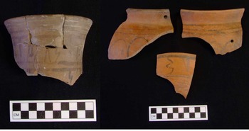
Xcopté and Uaymil are located west of Isla Cerritos and the centers of both sites contain temples, altars, and long, rectangular structures that housed columns and/or pillars, as well as pottery from the Slate Dzitas, Unslipped Sisal, Red Dzibiac, Plumbate Tohil, and Fine-orange Silho groups from Chichen Itza (Table 1). This architectural and ceramic evidence is also associated with Baca Red and Nimun Brown ceramic groups from the Canbalam sphere of the Cehpech ceramic complex, as well as ceramics belonging to the Muna Slate, Achote Black, Chablekal Gray, Vista Alegre, Koxolac, and Yalcox groups (Jiménez Álvarez Reference Jiménez Álvarez and Cobos2012; Jiménez Álvarez et al. Reference Jiménez Álvarez, Soldevila Illingworth, Palma, Cabadas Báez, Sosa, Castillo, Daneels and Pomedio2017; Maury Tello Reference Maury Tello2017; Robles Castellanos and Andrews Reference Robles Castellanos, Andrews, Laporte, Arroyo, Escobedo and Mejía2004; see Table 1 and Figures 6–8).
Uaymil: Dzibiac Red, Dzibiac Variety. Courtesy of the Uaymil Archaeological Project.

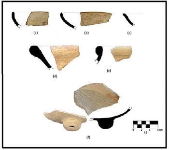
Uaymil: (a–e) Dzitas Slate, Dzitas Variety; (f) Dzitas, Becanchen Red-on-slate. Courtesy of the Uaymil Archaeological Project.
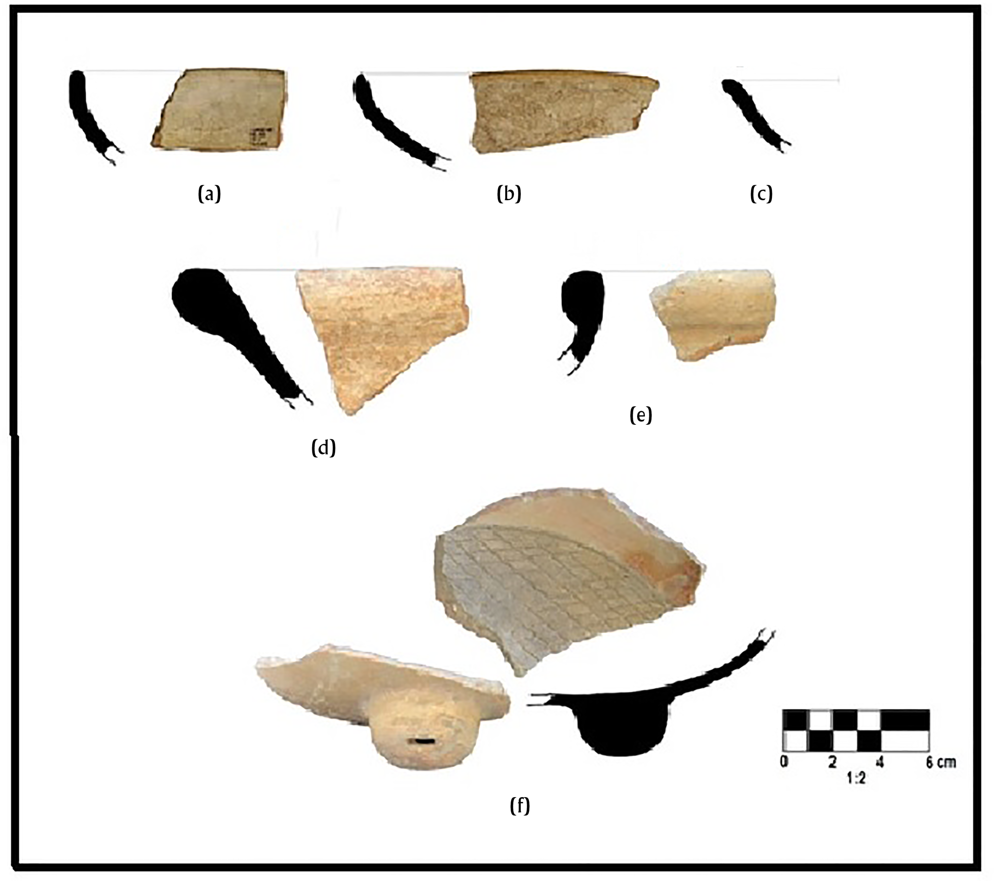
Uaymil: Baca Red, Baca Variety. Courtesy of the Uaymil Archaeological Project.

The presence of Chichen Itza's pottery with Cehpech ceramics from northwestern Yucatan suggests the coexistence at Xcopté and Uaymil of individuals of local origin and those who may have arrived from Chichen Itza—or some other region—but related to the latter site. In addition, the coexistence of both groups of individuals in these two maritime stations can be interpreted as an unbalanced and hierarchical relationship in which people associated with Chichen Itza dominated the original occupants of Xcopté and Uaymil, as evidenced by the presence of temples, altars, and rectangular structures with colonnades and/or pillars built in the central plazas of these two maritime stations (for a different interpretation, see Stanton and Gallareta Negrón Reference Stanton and Negrón2001).
There is no doubt that Xcopté and Uaymil—in addition to the island of Jaina—functioned as maritime stations under Chichen Itza's control, although Xcopté may have been part of Chichen Itza Province, whereas Uaymil and Jaina may have been situated outside of it. In other words, these three maritime stations fulfilled their specialized function of assisting in the transportation of tribute, although this payment could have been obtained in three different ways. For example, it seems likely that the tribute collected at Xcopté may have included maritime resources, such as Spondylus shells, fish, and slaves, and that this tribute was paid for by the local residents, considering the unbalanced dominance relations imposed by Chichen Itza.
The site of Uaymil, located on the northern coast of Campeche, was another maritime station of Chichen Itza, and the construction of colonnades associated with a temple and altar may have been due to a political and economic alliance with Uxmal during the tenth century (Inurreta Díaz Reference Inurreta Díaz2004; Inurreta Díaz and Cobos Reference Inurreta Díaz, Cobos, Laporte, Arroyo, Escobedo and Mejía2003a, Reference Inurreta Díaz and Cobos2003b). This alliance could explain the presence at Uaymil of structures architecturally similar to Chichen Itza that were built in a coastal settlement situated outside the territorial limits of Chichen Itza Province, but within Uxmal's territory that included part of the northern coast of Campeche, located 90 km to the west. In addition, Chichen Itza, in reciprocity with Uxmal, could have supported this site politically and militarily during the tenth and eleventh centuries to consolidate and maintain its supremacy in the Santa Elena valley. This political as well as military support probably prevented the expansion of other political units—Santa Rosa Xtampak? Dzibilnocac?—located within the Chenes region and, in this way, Uxmal could have been supplied with luxurious goods circulating in the sphere of Chichen Itza's domain.
The economic benefit that may have derived from the relationship between Chichen Itza and Uxmal is that the former site could have received gifts from the latter and, in addition, Chichen Itza may also have directly—and/or indirectly—obtained tribute from militarily conquered settlements in the Puuc region where Uxmal is located, as suggested by Robles Castellanos and Andrews's (Reference Robles Castellanos, Andrews, Sabloff and Andrews1986:84) interpretation of the murals depicted in the upper Temple of the Jaguars. Therefore, the political and military symbiosis between these two political units would explain the presence of ceramic materials characteristic of the Sotuta complex of Chichen Itza, such as Tohil Plumbate type, Fine-orange Silho group, and Chichen Slate and Chichen Unslipped wares associated with the Cehpech Puuc ceramic materials at Uxmal (Ball Reference Ball and Mills1979; Barrera and Huchim Herrera Reference Barrera Rubio and Herrera1990; Cobos Reference Cobos, Demarest, Rice and Rice2004, Reference Cobos and Díaz2010, Reference Cobos and Cobos2012b; Huchim Herrera and García Ayala Reference Huchím Herrera and Ayala2002; Huchim Herrera and Toscano Hernández Reference Huchím Herrera and Hernández1999; Konieczna and Mayer Guala Reference Konieczna and Guala1976; Kurjack et al. Reference Kurjack, Maldonado C., Robertson, Scarborough and Wilcox1991; Robles Castellanos Reference Robles Castellanos, Merino Carrión and Cook2006; Ruz Reference Ruz Lhuillier1954; Sáenz Reference Sáenz1975, Reference Sáenz1976).
Jaina, Southern Campeche, and Guatemala Province
Jaina is another maritime station located in western Yucatan and also exhibits a Cehpech ceramic component with Sotuta ceramics; however, it lacks the temple, altar, and colonnade and/or pillar arrangement because residents associated with Chichen Itza reoccupied Late Classic buildings (Ball Reference Ball1978; Benavides et al. Reference Benavides Castillo, Jiménez, Peniche, Aguirre, Ancona, Sauri and Euán2003, Reference Benavides Castillo, Jiménez, Daneels, Ancona, Sauri and Aguirre2005). The absence of the temple, altar, colonnade and/or pillar arrangement at Jaina suggests that this maritime station was apparently no longer within Chichen Itza Province, and wealth goods that circulated through Jaina may have been obtained from several settlements located inland in an area that extended from Edzná and Hochob to the north, to Becan, Río Bec, and Chicanna to the south. Also, these three latter sites were probably located on the northern boundary of Guatemala Province. The appearance of Fine-orange Silho, Plumbate Tohil, Red Dzibiac, and Slate Dzitas ceramic groups at Edzná, Hochob, Becan, Río Bec, and Chicanna in the tenth century reveals the presence of Chichen Itza in southern Campeche (Ball Reference Ball1977:135–136, 174–175; Boucher Reference Boucher and Aguilar2001:201–202; Carrasco and Boucher Reference Carrasco and Boucher1985:66). In addition, those four ceramic groups associated with Chichen Itza have not been found in the Chenes region located north of Hochob and south of Uxmal (Carrasco and Boucher Reference Carrasco and Boucher1985:66).
If Chichen Itza exacted tribute from the numerous sites in southern Campeche, we do not know the way in which this economic transaction was carried out, although the following options can be considered. First, the residents of southern Campeche settlements were militarily subjugated by opposing the total political domination that Chichen Itza wanted to impose on that region. Second, perhaps the inhabitants of the southern Campeche sites made diplomatic arrangements with Chichen Itza as a last attempt to stop their irreversible economic, political, and social misfortune between the tenth and eleventh centuries. Third, in an opportunistic manner, Chichen Itza obtained tribute through all and/or some of the forms defined by Hirth (Reference Hirth2020:177). It should be noted that Ball (Reference Ball1977:174–175, Table 1), based on ceramic evidence, proposed that during the Late Xcocom phase (a.d. 950–1050), Becan and Chicanna devoted special importance to obtaining Tohil Plumbate pottery from Guatemala, and this raises a question: how did they do it? In other words, did Becan and Chicanna use the distribution system of market exchange in the tenth century? Or does the presence of wealthy goods at Becan and Chicanna represent material evidence of collected tribute that made a centralized redistribution economy work at Chichen Itza? Bear in mind that Renfrew (Reference Renfrew, Earle and Ericson1977:88), as well as Stark and Garraty (Reference Stark, Garraty, Garraty and Stark2010:34, 51), specifies that the material imprints left by those two different types of exchange are spatially similar or identical, and, in this case, I favor the exact tribute explanation to interpret the southern Campeche and northern Belize evidence and suggest a different clarification.
According to Ball (Reference Ball1977:174–175), a new distribution network of wealthy goods emerged between the tenth and eleventh centuries that included northern Belize and southern Quintana Roo, and Becan was “the most probable interchange point between southeastern Campeche and Highland Guatemala.” This new distribution network of wealthy goods has also been identified in Naachtun during the tenth century (Nondédéo et al. Reference Nondédéo, Sion, García-Gallo, Cases, Hiquet, Okoshi, Chase, Nondédéo and Charlotte Arnauld2021; Sion et al. Reference Sion, Patiño-Contreras and Perla-Barrera2017).
Before and after the tenth century, Becan and Naachtun evidence a change in their interactions with other regions of the Maya area, and this shift is similar and simultaneous with that reported at Nohmul and San Juan in Ambergris Caye. For example, ceramic materials of the Fine-orange Altar and Fine-orange Balancan groups manufactured in Campeche and Tabasco, which “had constituted one of the Xcocom phase primary ceramic imports” (Ball Reference Ball1977:174) at Becan and Chicanna, ceased to be imported; instead, Plumbate Tohil group ceramics entered these two sites. At Naachtun, the late phase of the Muuch ceramic complex (a.d. 830–950/1000) ended in the middle of the tenth or early eleventh century, and Fine-orange Silho and Plumbate Tohil ceramics were found in Group C (Sion et al. Reference Sion, Patiño-Contreras and Perla-Barrera2017; see also Nondédéo et al. Reference Nondédéo, Sion, García-Gallo, Cases, Hiquet, Okoshi, Chase, Nondédéo and Charlotte Arnauld2021:97, 103). According to Sion (Reference Sion2016:315–348), members of the Naachtun elite acquired prestige wealth goods for domestic use by taking part in a new long-distance distribution network in which Chichen Itza actively participated.
The archaeological evidence of wealth goods found in the region between Edzná-Hochob and Naachtun-Becan has been interpreted as the material footprint of a new distribution network and Chichen Itza appears to be one of its key participants. However, if we use the same data and take a different approach, arguing that these are the physical remains of a wide range of actions planned and executed by Chichen Itza to collect tribute from Guatemala Province, then the interpretation changes completely. Furthermore, the site of Nohmul seems to have been a key settlement in the collection of that tribute.
Nohmul is located 3 km east of the Hondo River in northern Belize, and ceramic and architectural evidence suggests a Terminal Classic occupation (a.d. 1000–1100) with strong links to Chichen Itza and other northern lowland sites (see Chase and Chase Reference Chase and Chase1982; Hammond Reference Hammond1974:183–185, Figures 4–5, Plates XXII and XXIII-b, Hammond Reference Hammond1983:247–249). Like Becan, Nohmul is an intermediate site between the Guatemalan lowlands and highlands, and its proximity to the Hondo River positioned it as a strategic settlement between Guatemala and the Chetumal Bay and the Caribbean Sea coast. In fact, the Hondo River originates in southern Quintana Roo, and the waters of the Azul and Bravo rivers that originate in the northeastern part of the Peten (Guatemala) flow into the Hondo River.
Structure 20 is located at the center of Nohmul and this construction is a patio without a frontal gallery that overlies Classic period constructions (Chase and Chase Reference Chase and Chase1982; Hammond Reference Hammond1983:247, Figure 2). Structure 20 dates to the tenth century, based on its architectural similarity and contemporaneity with Structures 6E3 (Temple of the Hieroglyphic Jambs) and 2A17 at Chichen Itza. In addition, it should be noted that the archaeological evidence found at Chichen Itza's patios without frontal galleries (6E3, 2A17, 5D7) suggests that they had been built and functioned since the first half of the ninth century, although this was not the case for Structure 20 at Nohmul, especially when we consider the ceramic evidence.
Chase and Chase (Reference Chase and Chase1982:608) associated this building with the San José V period, taking into account the late presence of Sahcaba Modeled-Carved ceramic materials from Belize, Achote Black from southern Campeche and northern Peten, Northern Lowlands Maya pottery, including Puuc Slate, Thin Slate, and Peto Cream ceramic goods. Puuc Slate and Thin Slate ceramics were in use in the Northern Lowlands as early as the eighth century (see Ball Reference Ball1977; Robles Castellanos Reference Robles Castellanos, Merino Carrión and Cook2006). Regarding Peto Cream pottery, new analyses of this ware suggest its manufacture and use since the tenth century in that region and this contradicts Smith (Reference Smith1971), who dated this ware to the thirteenth century. Therefore, the chronological proposal of Chase and Chase (Reference Chase and Chase1982), on the finding of this ware at Nohmul, is in agreement with the new chronological framework of its regional distribution in the Maya Lowlands (see Bey III et al. Reference Bey, Bond, Ringle, Hanson, Houck and Lope1998; Jiménez Álvarez Reference Jiménez Álvarez and Cobos2016; Robles Castellanos Reference Robles Castellanos, Merino Carrión and Cook2006).
During the urbanization process of Chichen Itza, dated between the eighth and ninth centuries, patios without frontal galleries were associated with members of the elite who seem to have played a decisive role in the emergence of that city and political unit (Cobos Reference Cobos, Demarest, Rice and Rice2004, Reference Cobos and Cobos2016b). In the case of Structure 20, its construction occurred when Nohmul was in its collapse phase and when new settlers of non-local origin became the ruling elite of the site (Hammond et al. Reference Hammond, Donaghey, Gleason, Staneko, van Tuerenhout and Kosakowsky1987:280). It seems that during the tenth century, this non-local elite was in charge of turning Nohmul into a tribute-collecting center that was located far enough from politically problematic areas—such as southern and central Campeche and southern Quintana Roo—but very close to the Caribbean Sea coast where Chichen Itza appears to have established very successful political alliances that provided a more secure or stable economic and/or social environment for the transportation of tribute.
The internal layout of plazas at Isla Cerritos, Xcopté, and Uaymil, including temples, altars, and rectangular structures with colonnades and/or pillars has already been mentioned; however, patios without frontal galleries are nonexistent in these three maritime stations. Based on this information, it is tempting to argue that Chichen Itza's policy in its maritime stations situated in the Gulf of Mexico was to send individuals not belonging to the elite—or high social hierarchy—to administer them, due to the social, political, economic, and militarily unstable, fragile, or conflictive regions where Uaymil and Jaina were located. On the other hand, along the coast of the Caribbean Sea, political alliances must have dominated interactions between Chichen Itza and coastal settlements used as its maritime stations. It seems that these alliances did not allow Chichen Itza to control the seaports of Belize and eastern Yucatan, and this would explain the non-existence of the arrangement, consisting of a temple, altar, and rectangular structures with columns and/or pillars, as well as patios without frontal galleries (see below).
There is no doubt that Structure 20 at Nohmul turns out to be an exceptional case and, based on the material evidence, I suggest that this construction could have been used by the elite associated with Chichen Itza in the collection of tribute from Guatemala Province, whose northern boundary might have included Becan, Chicanna, Naachtun, and Nohmul. This elite must have had significant decision-making power to determine which settlements and/or regions demanded military conquest—as Miller (Reference Miller and Hammond1977:218) proposed for northern Peten—with which political alliances could be made, or with which communities’ tribute could be obtained in the form of gifts, occupation of their territories, payment of taxes, and so on (Hirth Reference Hirth2020:177). In addition, individuals belonging to this elite must have sent tribute to northern Yucatan by two routes: the first must have crossed southern Campeche to reach Hochob, Edzná, Jaina, Uaymil, Xcopté, and Isla Cerritos; the second route was along the coast of Belize and the eastern coast of Yucatan. Archaeological evidence clearly shows the importance that Chichen Itza gave to Guatemala Province, since it obtained Tohil Plumbate pottery, jadeite objects (Bishop et al. Reference Bishop, Sayre, Mishara and Lange1993), obsidian blades (Braswell and Glascock Reference Braswell, Glascock and Glascock2002, Reference Braswell, Glascock, Laporte, Arroyo and Mejía2007), cacao, and quetzal feathers (Morris Reference Morris, Morris, Charlot and Morris1931:409). According to McAnany (Reference McAnany2010:286) and Tokovinine and Beliaev (Reference Tokovinine, Beliaev, Hirth and Pillsbury2013:175–178), jadeite objects, cacao, and quetzal feathers are frequently represented in Classic period Maya sources.
Maritime Stations on the Caribbean Sea Coast
The presence of Chichen Itza in the numerous maritime stations located on the coasts of Belize and eastern Yucatan suggests that this political unit did not extract tribute from settlements located in that broad region. Unlike the way in which Chichen Itza may have collected tribute in northern and western Yucatan, as well in central and southern Campeche, maritime stations on the coasts of Belize and eastern Yucatan appear to have functioned as important strategic points to facilitate the transport of tribute collected in Guatemala Province. The transportation of tribute could have been achieved by political alliances that Chichen Itza established with several settlements along the Caribbean coast that still need to be identified archaeologically. For the successful establishment of these political alliances, Chichen Itza could have given gifts in an altruistic attitude to rulers or individuals of a high hierarchical position, who governed different coastal sites located in that region (Figures 9–10).
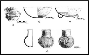
San Gervasio Cozumel: (a) Malacatan Modeled, Malacatan Variety; (b) Fine-orange Silho; (c) Chacmay Incised, Chacmay Variety; (d) Dzibiac Red. From Peraza Lope Reference Peraza Lope1993:Figures 113, 117, 118, 141.

San Juan, Ambergris Caye: Vessel SJ:5 Tohil Plumbate, variety unknown. Illustration by Jenny Martin, courtesy of the Maya Research Program.
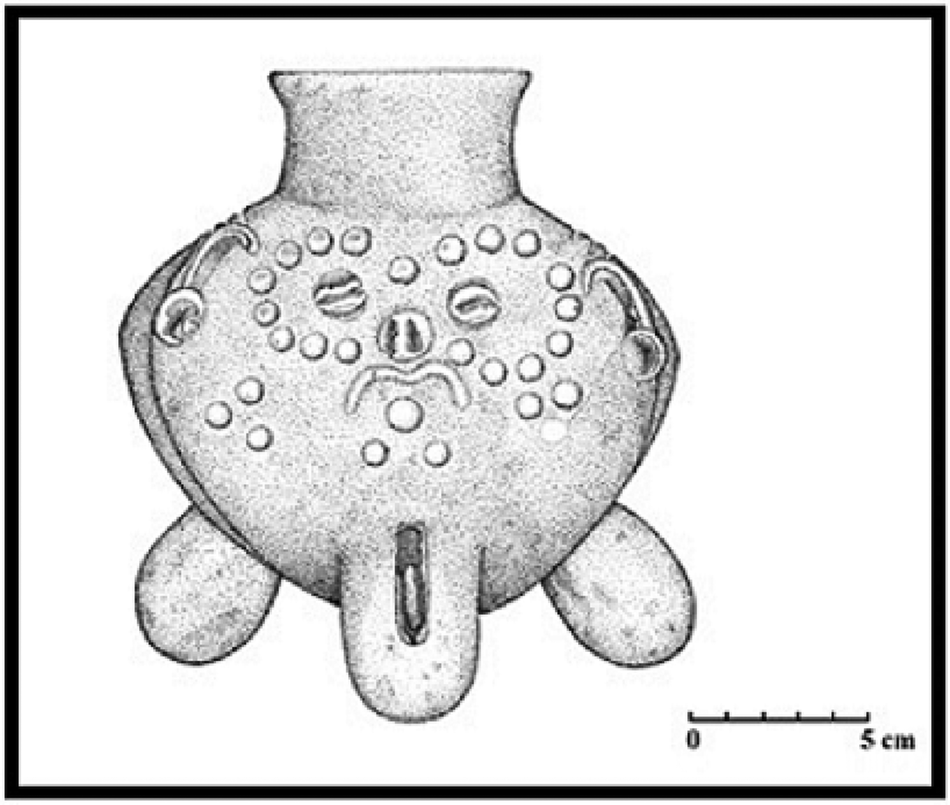
Furthermore, Chichen Itza does not seem to have invested in the construction of elaborate port complexes with central plazas containing temples, altars, and rectangular buildings with columns and/or pillars; nor were patios without front galleries built. The non-existence of all this infrastructure associated with Chichen Itza suggests the presence of individuals related to this site residing in modest structures made of perishable materials, constructed with simple stone platforms, as observed at El Meco (Structures 18, 23, 27; Andrews and Robles Castellanos Reference Andrews, Robles Castellanos, Andrews and Castellanos1986:62–64, Figures 2, 18), Chac Mool (Structures K, L, O, Q, R; Núñez Enríquez Reference Núñez Enríquez and Cobos2004:590–599, Figure 1), San Juan (Structures 1–8; Guderjan Reference Guderjan, Guderjan and Garber1995b:Figure 6, Reference Guderjan, Guderjan and Garber1995c), and Chac Balam (Structures 1–7; Driver Reference Driver, Guderjan and Garber1995:Figure 19; see also Guderjan Reference Guderjan, Guderjan and Garber1995b:19). At sites such as Vista Alegre and Marco Gonzalez, the remains of platforms associated with Terminal Classic period occupation are covered by structures dating to the Postclassic period (twelfth century onward) and this does not allow us to distinguish morphological features (see Glover et al. Reference Glover, Hruby, Rissolo, Ball, Glascock and Steven Shackley2018; Graham and Pendergast Reference Graham and Pendergast1989). At Wild Cane Cay, constructions from this period are underwater (McKillop Reference McKillop1996, Reference McKillop2009).
On the other hand, the most elaborate masonry architecture associated with Chichen Itza is noted at Xcaret, Playa del Carmen, and San Gervasio Cozumel, and consists of a one-room (chamber) building, with triple entrances defined by two columns (Figure 11). There is a small shrine inside this chamber with a single entrance, as observed in Structures C-I, B-I, and B-II in Playa del Carmen, constructions D-II and E-VI in Xcaret (Andrews IV and Andrews Reference Andrews and Andrews1975:Figures 28, 92, 98; Novelo Osorno Reference Novelo Osorno2005:12), and Structure A-IV-30 in San Gervasio Cozumel (Vargas de la Peña Reference Vargas de la Peña1992:127–130, Figure 22). At Chichen Itza, this type of construction includes Structures 2C1, 3C11, 5C7, 5D6, and 6B2-north (see Lincoln Reference Lincoln1990:410, Map Sheet I; Ruppert Reference Ruppert1952:13, 50–51, 124, 138).
Examples of one-room building with triple entrances, defined by two columns and small shrine inside. (a) Playa del Carmen Structure C-I, after Andrews IV and Andrews Reference Andrews and Andrews1975:Figure 98; (b) San Gervasio Cozumel Structure A-IV-30, after Vargas de la Peña Reference Vargas de la Peña1992:Figure 22; (c) Chichen Itza Structure 6B2-north, after Ruppert Reference Ruppert1952:Figure 100. Figures redrawn by Aurea Hernández.

The site of Chac Mool is located on a small peninsula between the bays of Ascension and Espiritu Santo, and in the sixteenth century, Friar Alonso Ponce reported the existence of the settlement as follows:
En la tierra firme, junto á esta bahía; y puerto, hay algunos edificios de cantería, de tiempos antiguos, y dicen los indios que eran templos de los dioses é idolos de los señores de Chicheniza, y cuando querian pasar á Honduras por cacao y plumas, y otras cosas, iban y venian por alli á ofrecerles sacrificios (Salvá y Ramírez Arellano y Gutiérrez de Salamanca Reference Salvá and Feliciano Ramírez Arellano y Gutiérrez de Salamanca1872:408).
The masonry buildings to which Alonso Ponce seems to have referred are possibly the simple platforms made of worked stones. Furthermore, if elaborate shrines like those reported at Xcaret, Playa del Carmen, and San Gervasio Cozumel once existed at Chac Mool, they were probably destroyed when the site was reoccupied during the Postclassic period (González Licón and Cobos Reference González Licón, Cobos, Morfín, Espinosa and Licón2006).
Chichen Itza did not establish land stations in a large inland region located between eastern Yucatan and the Caribbean Sea coast (Figure 1). Unlike the revitalization process that Chichen Itza promoted at Xuenkal and Kulubá, that political unit did not engage in bolstering the northern region of eastern Yucatan that was depopulated during the Late Classic and reoccupied until the late Terminal Classic and Postclassic periods (Glover Reference Glover2012:279–281). Moreover, the regions of Coba (Robles Castellanos Reference Robles Castellanos1990:38–40), Cochuah (Shaw Reference Shaw and Shaw2015:11–14), and southern Quintana Roo (Lagartera, Margarita [Villamil Reference Villamil2009:120–122], and Dzibanché [Nalda Reference Nalda and Morlet2000:69–70]; see also Fry Reference Fry, Rice and Sharer1987) began their collapse and depopulation between the tenth and eleventh centuries, and there is no evidence of Chichen Itza's presence in these three areas, unlike what happened in the territory located between Edzná/Hochob and Becan, Naachtun, and Nohmul.
Why was Chichen Itza absent in eastern Yucatan, Coba, Cochuah, and southern Quintana Roo regions? Was the social and political environment that existed in that vast region extremely volatile and Chichen Itza did not have powerful political allies? Why was Chichen Itza not interested in revitalizing that extensive region, as it did in southern Campeche, northern Peten, and northern Belize? Perhaps the procurement of tribute could have represented a risky economic and military challenge that was not at all profitable for Chichen Itza? Based on the current archaeological evidence, it is impossible—for now—to answer these questions; however, it is clear that Chichen Itza's rulers and administrators were aware of the unstable social, political, and economic conditions prevailing along the coasts of the Gulf of Mexico, Caribbean Sea, and Northern Lowlands at the end of the Terminal Classic period.
CONCLUSION
This article argues that tribute collection by Chichen Itza and centralized redistribution played an important economic role in the heyday, expansion, and territorial dominance of this political unit in certain regions of the Maya Lowlands during the tenth and eleventh centuries. Tribute collection and centralized redistribution seem to have functioned under specific or particular circumstances during times of social, political, and economic crisis—in other words, at the time of the Maya collapse. In these times of crisis, Chichen Itza may have exercised its warlike power to appropriate key regions and settlements; it could have established political alliances; it could have accepted being a protective political unit for sites undergoing dramatic transformations; it could have been the agent that selectively revitalized some regions or settlements for its own benefit. This was the social and political scenario in which Chichen Itza emerged as an opportunistic entity, considering the regional deterioration of social, political, and economic conditions in the Northern Lowlands.
Considering the spatial aspects of the archaeological evidence in this article, tribute and centralized redistribution are proposed as an alternative explanation in the reconstruction of Chichen Itza's economy between a.d. 900 and 1100, and two things are worth highlighting. First, the archaeological data can be interpreted from another economic perspective, considering that the material evidence of centralized redistribution and market exchange are spatially similar; therefore, more research is needed to reach a scientifically acceptable consensus of why we favor one explanation over the other. Second, archaeological evidence from the Northern Maya Lowlands, dated to the tenth century, has been interpreted as a “new form of trade” associated with market exchange. However, this same evidence could also be explained as a well-planned, very selective, and efficiently orchestrated economic behavior by Chichen Itza, whose ultimate purposes were to collect tribute from sites and regions in an opportunistic manner during the Maya collapse.
The land and sea routes used to send tribute to Chichen Itza suggest different forms of interaction between this political unit and sites located in different areas of the Maya Lowlands. For example, a vast territory of central and northern Yucatan seems to have formed Chichen Itza Province, over which this site probably had total control. On the western coast of Yucatan, alliances with Uxmal and the opportunistic occupation of Jaina may have required Chichen Itza to execute a different policy and not exercise total control of this region. In addition, this same policy may have been implemented along the coast of the Caribbean Sea, which allowed Chichen Itza to safely transport tribute obtained from sites and/or regions located in the Southern Maya Lowlands. Inland, in southern Campeche as well as a region that appears to have been the northern boundary of Guatemala Province, Chichen Itza may have opted to use a wide variety of political, military, and economic actions to extract tribute. Likewise, on the northern boundary of Guatemala Province, Nohmul appears to have been a key outpost site in the procurement of that tribute, and its close location to the Caribbean Sea and Belize coastal sites associated with Chichen Itza suggest a stable and secure political and social environment that does not appear to have been a threat to this political unit.
To conclude, the reconstruction of ancient economies is not an easy task. Based on the abundant archaeological information, with the strong economic interpretation available today, the researcher has a wide selection of arguments with which to embark on the challenge of interpreting past economic transactions that left their material imprint. Therefore, different explanations must be taken into account in our attempts to interpret convincingly those transactions that could have functioned, in stable times, as well as in times of crisis.
RESUMEN
Estudios sobre la antigua economía asociada con la civilización maya de los períodos clásico y posclásico muestran que, para explicarla, se ha utilizado ampliamente el modelo de economía de mercado, cuyas transacciones se realizaban en lugares de mercado. En este tipo de economía los bienes son intercambiados, tomando en cuenta un valor acordado considerando la oferta y la demanda. Sin embargo, otros tipos de intercambio, como el tributo y la redistribución centralizada, pudieron haber sido utilizados en esas transacciones en vez de la economía de mercado. En este trabajo se analiza el papel que pudieron haber jugado el tributo y la redistribución centralizada durante el apogeo de Chichén Itzá entre los siglos diez y once. Este sitio parece haber utilizado su poderoso poder militar para extraer tributo de sitios y regiones que conquistó militar y políticamente cuando vivían su colapso. Además, la evidencia arqueológica sugiere que Chichén Itzá realizó alianzas político-económicas en diferentes regiones de las tierras bajas mayas con el fin de obtener bienes suntuosos. Estos bienes fueron utilizados por miembros de la élite para reforzar la estructura de poder y consolidar relaciones sociales entre los distintos miembros que vivieron en esa comunidad del norte de Yucatán.