Introduction
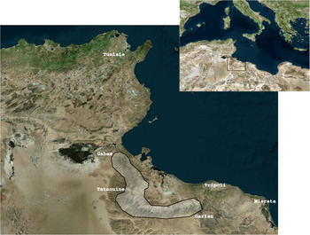
La zone d’étude choisie est assez spacieuse et compte près de 39000 km2 dont 24900 km2 se situent dans la partie tunisienne et près de 14000 km2 en Libye (Figure 1). Géographiquement, elle s'étend du sud de la Tunisie, plus précisément de la montagne de Matmata à l'ouest de la ville de Gabès, en passant par la région de Bani Khaddash et Tataouine jusqu’à Dhehiba sur la frontière, où se trouve la montagne connue sous le nom de Demmer, atteignant le mont Nefoussa en Libye, qui s’étend de Wazen, Nalut, Zenten, Yafren jusqu’à Gharrian.
Zone du travail (© 2020 Microsoft Corporation, Maxar, CNES, Distribution Airbus DS, Earthstar Geographics SIO).

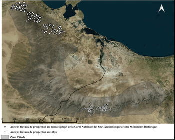
Les anciens travaux de documentation du patrimoine archéologique dans ces régions se sont limités à quelques zones en raison des difficultés d'accès. Pour la Tunisie, il faut citer la carte d'El Idrissi faite en 1893 et le projet de la Carte Nationale des Sites Archéologiques et des Monuments Historiques au sein de l'Institut National du Patrimoine dont les travaux ont atteint les limites de notre zone d’étude et se sont concentrés majoritairement sur les sites romains (Mrabet Reference Mrabet1996; Reference Mrabet1998; Reference Mrabet2000a; Reference Mrabet2000b; Reference Mrabet2016).
Il en est de même du côté libyen, la documentation étant partielle et limitée aux travaux effectués par le Département d'Antiquité Libyenne et aux travaux des missions italiennes et américaines (Nebbia et al. Reference Nebbia, Leone, Bockmann, Hddad, Abdouli, Masoud, Elkendi, Hamoud, Adam and Khatab2016) (Figure 2).
Les anciens travaux de prospection (© 2020 Microsoft Corporation, Maxar, CNES, Distribution Airbus DS, Earthstar Geographics SIO).

Cette chaîne montagneuse est caractérisée par la présence d'un nombre important de vestiges archéologiques de différents types et périodes. Outre les édifices troglodytiques et les greniers fortifiés (ksour) qui constituent une spécificité régionale (Despois Reference Despois1935 ; Louis Reference Louis1975 ; Zaied Reference Zaied1992 ; Laroussi Reference Laroussi2010 ; Popp et Kassah Reference Popp and Kassah2010), ces montagnes, en Tunisie comme en Libye, sont jonchées de monuments hydrauliques, défensifs (citadelles ?, fortifications ?), économiques et religieux. La prospection et la documentation de cette zone permettront évidemment la mise à jour d'un potentiel archéologique encore mal connu. Ces travaux de documentation seraient plus efficaces s'ils étaient couronnés par des décisions qui permettraient la protection et la sauvegarde de ce patrimoine. Cela “ne sera” possible que par l'implication du processus de gestion qui permettrait de dresser une liste des priorités et qui prendrait en considération la valeur, le diagnostic et le constat d’état.
Afin d'établir ce plan de gestion, il est essentiel de documenter la zone d’étude et d'identifier le patrimoine archéologique présent. Ensuite, il faudra faire ressortir les différentes valeurs et procéder au diagnostic par l'examen des différentes menaces susceptibles de contribuer à l'altération, et finir par l’évaluation de l’état de conservation.
Prospection et documentation du patrimoine archéologique
Les travaux de prospection et de documentation étaient basés sur l'utilisation d'une nouvelle technologie dont l'outil de base est la télédétection suivant la méthodologie du projet EAMENA (Rayne et al. Reference Rayne, Bradbury, Mattingly, Philip, Bewley and Wilson2017). L'utilisation de QGIS a été aussi primordiale dans cette étape. Ce dernier a permis une manipulation facile et rapide des données d'une manière fiable (Anna et al. 2020).
Avant de procéder à la prospection satellitaire, des étapes préparatoires étaient obligatoires afin de permettre de constituer une base de connaissance sur laquelle on s'appuierait pour mener à bien la documentation et le recensement du patrimoine archéologique. Parmi les étapes préliminaires effectuées, citons la documentation bibliographique de la région d’étude.
Collecte bibliographique
Cette phase constitue une étape primordiale. Elle permet de prendre une idée générale sur la zone d’étude. Toutes les données qui sont en relation et qui peuvent contribuer à une bonne connaissance du patrimoine archéologique dans les différentes zones d’étude ont été collectées – en l'occurrence, les photos d'archive, les publications et les études effectuées sur les différentes zones ainsi que les cartes topographiques et archéologiques.
Géoréférencement des anciennes cartes topographiques
Un intérêt particulier a été attribué aux cartes topographiques qui ont été considérées comme la base du travail. Toutes celles qui couvrent la zone d’étude ont été collectées. Pour la partie tunisienne, on s'est basé sur les cartes 1:200000 et 1:100000 réalisées en 1940 par l'armée française au cours de la deuxième guerre mondiale. En ce qui concerne la Libye, les cartes 1:100000 de l'armée américaine datées de 1943, qui étaient basées sur les travaux de prospection faites par l'armée italienne en 1934, ont servi comme base de travail. Ces anciennes cartes ont été tout d'abord géoréférencées. Ensuite, tous les points qui témoignent de l'existence de sites archéologiques et de monuments historiques ont été enregistrés sous une couche shapefile en utilisant le logiciel QGIS. Les points enregistrés ont été ensuite exportés vers Google Earth Pro afin de les corriger spatialement.
De ce fait, nous avons obtenu un support sur lequel est enregistré un nombre important de vestiges archéologiques qui étaient inspectés directement et depuis près d'un siècle. Il est essentiel de noter, à ce stade, qu'au cours de la correction spatiale des points, nous avons remarqué la disparition totale d'un nombre important de monuments. Cela est dû évidemment aux difficultés qu'affronte ce patrimoine dans ces zones à haute altitude exposées à plusieurs types de menaces.
Télédétection
La télédétection a été faite à partir de Google Earth Pro. Les points déjà recueillis à partir des cartes topographiques étaient la base sur laquelle la prospection a été complétée. Toutes les zones ont été prospectées minutieusement à l'aide de l'imagerie satellitaire et en utilisant différentes dates de la prise des images afin d'avoir des résultats plus fiables. Malheureusement, certains types de sites et de monuments n’étaient pas visibles même sur des images satellites à très haute résolution. Dans notre cas, la résolution des images était parfois faible et ne permettait pas de détecter toutes les traces archéologiques. Ces zones montagneuses ne disposent pas d'une haute résolution et il en va de même pour la zone saharienne qui délimite les deux pays, vu que c'est une zone militaire.
Pour pallier ce problème, l’équipe de travail a été formée majoritairement de chercheurs originaires de ces différentes régions et/ou y ayant effectué des recherches scientifiques. On s'est basé donc sur notre bonne connaissance du terrain pour enregistrer la plupart des points.
Les points recueillis lors de la télédétection ont été fusionnés avec ceux collectés à partir des anciennes cartes topographiques. Les travaux de documentation ont livré ainsi 902 points en Tunisie et plus de 2 000 points prospectés en Libye.
Dans une dernière phase, une base de données a été effectuée pour tous les points collectés. Elle renferme des informations sur le monument, sa condition physique et les menaces qui sont apparentes à partir des satellites. Cette base a été réalisée à partir d'une version du Collect Earth (plateforme Arches v.3) qui a été conçue spécialement pour fonctionner avec la base de données du projet EAMENA (Hobson Reference Hobson2019).
Visite de terrain
Les visites sur terrain sont à la fois un travail complémentaire et nécessaire. Elles permettaient la vérification des points déjà collectés pendant la phase de géoréférencement et de prospection satellitaire. Comme on l'a déjà signalé ci-dessus, la réalisation d'un plan de gestion constitue l'un des buts essentiels. Ce plan ne pourra pas être fiable sans la visite de terrain et l’évaluation directe des différentes composantes de ce patrimoine. Vu que le projet était limité dans le temps, il a fallu choisir quelques sites et monuments à visiter.
Un bon choix n'a été possible que par la réalisation d'un plan de gestion préliminaire via les images satellitaires. Il a fallu examiner et analyser tous les vestiges archéologiques enregistrés, évaluer leurs valeurs, leurs conditions physiques et les facteurs de détérioration, afin d’établir une liste prioritaire des sites et de monuments à visiter.
Pour ce qui est de l’évaluation des menaces et des altérations, elles ont été jugées grâce à des comparaisons d'images satellitaires prises à des temps différents. Il s'est avéré qu'il est impossible de faire une évaluation exacte de l’état physique à partir des satellites. Cependant, quelques types de menaces étaient détectables à partir des images satellitaires, telles que l'extension urbaine et les spoliations dues à des fouilles clandestines.
L'utilisation de « Google Earth Engin » a été aussi nécessaire dans la phase d'analyse des différentes menaces. Il a permis de contrôler l’évolution de la couverture végétale, du réseau hydraulique et de l'extension urbaine.
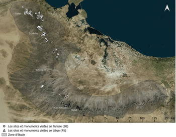
Difficile à déterminer à partir des images satellitaires, l’évaluation des valeurs a été établie en se basant souvent sur nos connaissances préalables. Une liste des sites archéologiques et des monuments historiques a été enfin tracée et programmée pour les visites dans les deux pays. En ce qui concerne la Tunisie, le plan de gestion a été respecté intégralement et une liste de sites et monuments prioritaires a été établie. Malheureusement, en Libye, cette stratégie n'a été que partiellement respectée vu la situation dans le pays. Une sélection des sites et des monuments a été effectuée en fonction de la sécurité des zones de guerre et de la stabilité sociale. La visite d'une quarantaine de sites et monuments a été enfin programmée dans seulement deux régions, Nalout et Oued Ghezaia (Figure 3).
Répartition des sites visités (© 2020 Microsoft Corporation, Maxar, CNES, Distribution Airbus DS, Earthstar Geographics SIO).

Intégration des communautés locales
La charte de base du travail de terrain est l'assistance des communautés locales. La majorité des visites a été organisée en collaboration avec elles. Ces dernières ont contribué de manière significative aux travaux de documentation. Plusieurs sites et monuments ont été ajoutés à la base de données grâce aux autochtones. Leur bonne connaissance du terrain a facilité énormément la tâche.
Ce contact a résulté, d'une manière indirecte, à la sensibilisation de ces communautés. Une bonne connaissance de leur patrimoine et la conscience de ses différentes valeurs les encourageaient à le protéger.
Les méthodes de documentation
De différentes méthodes de documentation ont été utilisées et basées sur l'utilisation de nouvelles technologies :
– Le GPS (Global Positioning System) a été utilisé pour enregistrer les coordonnées des sites visités. Son utilisation a été bénéfique à deux niveaux. Elle a permis d'une part de corriger la localisation de quelques points qui ont été déjà enregistrés à partir des photos satellitaires. D'autre part, il enregistre la position des nouveaux sites découverts, ce qui facilite leur ajout à la base de données.
– La documentation photographique : c'est la méthode classique de documentation. Une couverture photographique détaillée a été réalisée pour chaque point visité.
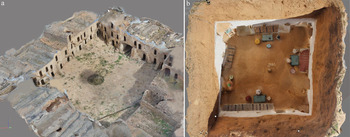
– Documentation 3D (photogrammétrie) : cette méthode a été réalisée pour certains monuments qui présentaient une combinaison de plusieurs valeurs et des spécificités régionales tels que les ksour, les fortifications et les habitats troglodytiques (Figure 4).
– Les relevés architecturaux (plan/coupe/façade) : des relevés ont été faits pour certains monuments. Ce sont ceux qui présentaient une spécificité architecturale ou qui étaient d'une valeur scientifique considérable.
Photogrammétrie : documentation 3D. a) Ksar Ouadide à Tataouine ; b) habitation troglodyte à Matmata.

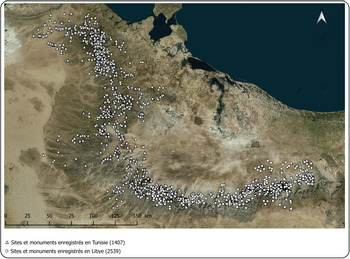
Au cours de ces travaux de terrain, de nombreux monuments ont été accidentellement découverts alors qu'ils n'avaient pas été détectés par prospection satellitaire. Cela confirme la complémentarité entre la prospection de terrain et la télédétection. Par conséquent, le nombre de points documentés a énormément augmenté. En Tunisie, il est passé de 902 à 1 407 sites et monuments, et en Libye, le nombre total a atteint 2 539 points. Le résultat final des travaux de documentation a atteint 3 946 sites archéologiques et monuments historiques dans les deux pays (Figure 5).
Les sites archéologiques et les monuments historiques prospectés dans la chaîne montagneuse tuniso-libyenne (2019) (© 2020 Microsoft Corporation, Maxar, CNES, Distribution Airbus DS, Earthstar Geographics SIO).

Plan de gestion et de conservation du patrimoine archéologique tunisien
La phase de documentation a permis de mettre au jour un nombre important de sites archéologiques et de monuments historiques. Il a fallu établir une stratégie pour les conserver, ce qui n’était possible que par la conception d'un plan de gestion.
Ce présent document exposera les résultats préliminaires de ce projet. Malheureusement, ce processus de gestion n'a pas pu être réalisé pour le moment en Libye puisque le choix des sites et monuments visités a été orienté vers les zones stables et qui sont loin des champs de batailles. Cependant, et afin de faire une feuille de route, il a fallu visiter les points prioritaires ressortis lors de la télédétection. On se contentera donc de fournir un plan de gestion de la partie tunisienne.
Pour ce faire, toutes les étapes du processus de gestion ont été respectées : analyse des valeurs, des menaces et de l’état de conservation (Demas Reference Demas1995 ; Papadopoulos Reference Papadopoulos1995 ; Stanley-Price Reference Stanley-Price1995). L'outil de travail sur lequel toutes les évaluations ont été enregistrées est le logiciel QGIS. Dans la table d'attributs de ce dernier, des cases ont été ajoutées en fonction des besoins. Ce logiciel nous permettra de fusionner les données et de ressortir le résultat voulu en un temps record.
Importance de la chaîne montagneuse du sud tunisien
La diversité architecturale, la richesse archéologique, le volet artistique et esthétique, l'importance historique des sites et des monuments qui s’étendent sur une longue période allant de la préhistoire à la période contemporaine sont autant de valeurs qui caractérisent ces régions montagneuses. Au cours du travail de terrain, différentes valeurs ont pu être révélées. Cependant, on s'est basé sur notre connaissance du terrain et sur les images satellitaires pour extraire les valeurs des sites et monuments qui n'ont pas pu être visités.
Ci-dessous sont exposées les valeurs rencontrées généralement.
Valeur géologique
Quelques montagnes de ces régions d’étude présentent une valeur géologique unique en Afrique du Nord. En l'occurrence, un affleurement du Permien marin (290 Ma à 250 Ma) à Jebel Tebaga à Mednine au sud tunisien. Ce dernier constitue l'unique affleurement Permien supérieur marin dans le continent africain (Douvillé et al. Reference Douvillé, Soulignac and Berkaloff1933).
À Jebel Demmer, dans les montagnes de Mednine et Tataouine, des traces de pas et des restes de dinosaures ont été découverts. Le squelette du jebel El Mra à Tataouine au sud du village du Bir Amir, appelé Tataouinea hannibalis, est considéré parmi les mieux conservé d'Afrique du Nord. Il remontait à près de 130 Ma et a été déclaré similaire à ceux découverts en Amérique du Sud (Fanti et al. Reference Fanti, Cau, Hassine and Contessi2013 ; Reference Fanti, Cau, Cantelli, Hassine and Auditore2015).
Au cours de la phase de documentation et de travail sur le terrain, nous avons enregistré un nouveau site géologique qu'on a appelé « la forêt fossilisée » vu la densité des bois fossilisés éparpillés.
Les couches géologiques de certaines zones de ces montagnes avaient livré des gisements de matières premières tels que le silex, le gypse, la chaux et le calcaire qui ont été utilisés au cours de plusieurs périodes.
Valeur historique
Les successions chronologiques des occupations dans les montagnes de Matmata et Demmer reflètent le potentiel archéologique et historique. La nature de cette chaîne montagneuse a incité nos prédécesseurs à s'y réfugier. Cependant, depuis la fin du Pléistocène moyen, ces montagnes étaient utilisées comme des zones refuges pendant les périodes arides (Spinapolice et Garcea Reference Spinapolice and Garcea2013 ; Reference Spinapolice and Garcea2014). À Jebel Gharbi en Libye, une occupation à Aïn Zarga appartenant au « Early Middle Stone Age » a été datée de 146 ka (Garcea Reference Garcea2012). Ces occupations ont continué jusqu’à la fin du Pléistocène supérieur où des sites atériens à Aïn Shakshouk et Wadi Sel ont été datés à près de 44 ka (Garcea et Giraudi Reference Garcea and Giraudi2006 ; Garcea Reference Garcea2012). La continuité de ces occupations en Tunisie a été répertoriée à Jebel Demmer, plus précisément à Oued el Khil et Meutameur (Ben Fraj Reference Ben Fraj2012) et à Beni GuendilFootnote 1. La prospection a permis de mettre au jour une occupation qui remonte à cette période à Mednine, plus précisément à Ras Chaabet Saboun à l'oasis El Hallouf.
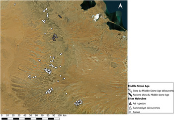
Une continuïté d'occupations préhistoriques jusqu’à l'Holocène a été prouvée à Jebel Gharbi en Libye (Barich et al. Reference Barich, Lucarini and Mutri2015). Aussi, des restes de cette période ont été récemment découverts au sud tunisien dans le cadre de ce projet. Ainsi, à Jebel Demmer, trois rammadiyet ont été identifiées dans une région actuellement saharienne. Deux autres rammadiyet ont fait également l'objet d'une découverte récente (prospection réalisée par Lotfi Belhouchet et Hela Mekki en 2019) à Jebel Matmata (Figure 6).
Les sites préhistoriques et protohistoriques aux Jebels Demmer et Matmata (© 2020 Microsoft Corporation, Maxar, CNES, Distribution Airbus DS, Earthstar Geographics SIO).

Des témoins de cette période sont aussi connus dans la région de Ghomrassen. Il s'agit des stations d'art rupestre d'Insifri (Gragueb Reference Gragueb1990) et de Chaabat El-Maarek (Ghrabi Reference Ghrabi2008).
Pour ce qui est de la période protohistorique, plusieurs monuments tels que bazinas et tumulus ont été auparavant mis au jour dans cette région (Paris et Ghaki Reference Paris and Ghaki2010). Les travaux de télédétection et de prospection de ce présent travail ont permis d'enregistrer près de 200 tumuli éparpillés notamment au niveau des sommets des montagnes (Figure 6). Ils sont de dimensions variables dont certains ont atteint plus que 4 m de diamètre.
L'occupation de ces montagnes a continué durant les périodes antiques et les restes archéologiques en témoignent. Des ruines romaines sont éparpillées tout au long de cette chaîne. Notons comme exemple le en italique romain qui marque la frontière militaire de l'Empire romain. Ils sont présents dans plusieurs endroits tels qu'Oued el Hallouf, Ksar Tarcine (centenarium Tibubici), le fortin de Bényet bel khecheb à Beni Khdech, Ksar Chouline à Oued el Mrabtiya et Ras el aïn el Farch à Oued Tellalet à Ghomrassen, Gribiaa à Remada, etc. Tous ces sites appartiennent au limes Tripolitanus (Trousset Reference Trousset1974 ; Mattingly Reference Mattingly and Talbert2000).
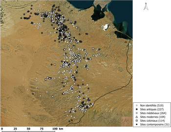
Au cours des travaux de documentation, plusieurs ruines romaines ont été enregistrées soit en se basant sur notre connaissance du terrain soit sur les anciennes cartes topographiques où étaient mentionnés plusieurs ruines (ce mot est plus adapté car il correspond au R. de R.R. !) romains (noté R.R). Un total de 227 points a été classé comme ruine antique dont la plupart sont des citernes et des points d'eau, quatre huileries et plusieurs autres monuments non identifiés (Figure 7).
Répartition des sites selon les périodes historiques (© 2020 Microsoft Corporation, Maxar, CNES, Distribution Airbus DS, Earthstar Geographics SIO).

D'après les sources littéraires et les voyageurs du IXe et Xe siècles, ces montagnes ont continué à jouer le rôle de refuge au cours de la période médiévale, notamment après la guerre de Mano (895 ap. J.-C), où les tribus berbères étaient réfugiées et avaient édifié des monuments pour s'installer et se défendre. Les citadelles de la région de Matmata et Bani Khaddash ont été considérées comme un témoin de l'urbanisme pendant cette époque, tandis que les ksour (greniers) présentent une spécificité de la région de Tataouine (Louis Reference Louis1975). Plus de 100 citadelles ont été découvertes lors du travail de télédétection et de visite de terrain ; 174 ksars ont été aussi enregistrés, alors que le nombre total des ksour auparavant connu était de 160 ksars. La construction de ces deux types de monument a persisté jusqu’à la période moderne, comme les matériaux de construction et les types de toitures le confirment.
Pour la période moderne, le peuplement de ces montagnes était lié à la propagation des édifices religieux afin de diffuser la doctrine sunnite officielle de l'État dans ces régions qui adoptèrent une doctrine opposée (Ibadhite), ce qui explique le grand nombre de marabouts et de zaouia qui ont été enregistrés durant la phase de documentation (273 zaouia, marabout, houta, etc.) (Figure 7).
La période coloniale est marquée par l'existence des camps militaires (entre Mareth et Toujène) qui se rapportent à la deuxième guerre mondiale. On a enregistré 114 monuments coloniaux dont nombreux puits et citernes (Fasaki) (Figure 7).
Valeur architecturale
Les occupations de cette chaîne montagneuse montrent une diversité architecturale. L'architecture troglodyte et l'architecture des greniers (ksour) constituent des marqueurs et des symboles locaux (Habouria Reference Habouria2016 ; Rekik Reference Rekik2016 ; Znidi Reference Znidi2018). Les habitations troglodytes sont présentes tout au long de la chaîne montagneuse sous différents aspects (Prost Reference Prost1954 ; Louis Reference Louis1968 ; Louis et Hallet Reference Louis and Hallet1979 ; Popp et Kassah Reference Popp and Kassah2010). Ces habitations varient d'une région à une autre selon la nature du sol et du climat. Dans les zones montagneuses constituées de « loess » (Coudé-Gaussen Reference Coudé-Gaussen1984 ; Mathieu, Reference Mathieu1949), elles sont creusées entièrement dans le sol (Louis Reference Louis1968 ; Habouria Reference Habouria2016 ; Znidi Reference Znidi2018). Formée de pièces creusées autour d'une cour principale à ciel ouvert, cette architecture reflète l'adaptation de l'homme à son environnement. En dehors de Matmata, Hadej, Tijma en Tunisie, Gheriane et Tandamira en Libye et quelques autres endroits dans les montagnes tuniso-libyennes, les monuments troglodytiques sont rares dans le monde. Ils en existent au Mesa Verde dans le Colorado (550 ap. J.-C.), au Bamiyan en Afghanistan, Biandiagara au Mali (XIIIe siècle), Vardzia en Georgie (XIIe siècle), Kandovan en Iran (XIIIe siècle) mais les seuls qui ressemblent architecturalement aux nôtres sont les maisons troglodytes de la province du Shaanxi au nord-ouest de la Chine (Shen Reference Shen2014).
Dans d'autres régions tel que Jebel Demmer, on trouve rarement ce modèle, et d'une façon plus prépondérante ce sont les (pour éviter la répétition de on trouve) « Ghiren » qui sont aussi creusés dans les flancs et ressemblent aux grottes dont la majorité était entourée à l'extérieur par de petites enceintes. Un troisième type, ce sont les monuments semi-creusés qui sont en partie creusés dans le sol et complétés par une structure bâtie. Un quatrième type, ce sont les monuments bâtis qui sont généralement dans les zones à proximité des carrières de pierre (Znidi Reference Znidi2018).
D'autres spécificités architecturales sont à noter comme les greniers collectifs dont certains sont fortifiés. Cette architecture est conçue spécialement pour l'approvisionnement des réserves alimentaires. L'architecture de ces greniers et leurs matériaux de construction favorisent la conservation des provisions et aident à lutter contre les conditions climatiques super-arides (Despois Reference Despois1935 ; Louis Reference Louis1975). Elle reflète l'interaction de la population locale avec leur environnement.
Plusieurs autres types de monuments exposent une valeur architecturale. Notons comme exemple les citadelles, les huileries (Mrabet Reference Mrabet1997), les mosquées, etc.
Valeur esthétique
La diversité archéologique est accompagnée sans aucun doute par une richesse esthétique. La spécificité qui met en valeur ce côté esthétique est l'harmonie créée entre l'environnement, la nature et les vestiges archéologiques, notamment les monuments qui se situent à haute altitude.
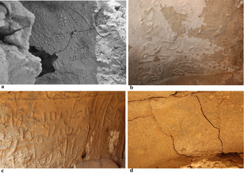
Outre le côté esthétique inspiré des conditions extérieures et de la nature d'implantation, certains monuments tirent leur valeur esthétique de leurs propres composantes. Quelques monuments contiennent des composantes architecturales et des inscriptions rares. Notamment des « moukharbachet », ainsi que des gravures et des différents types de décors attestés dans plusieurs ksour et monuments troglodytiques domestiques et religieux (Figure 8).
Valeur esthétique : décors et “moukharbachet”. a) Ksar Khrachfa à Mednine ; b) maison troglodyte à Haddej Matmata ; c) kasbet Manit, Mednine ; d) ksar Hafsa, Mednine.

Les ksour sont aussi dotés d'une valeur esthétique considérable par leur architecture, leurs composantes telles que les toitures voûtées de différents types et leurs matériaux de constructions qui créent une magnifique harmonie.
Valeur sociale
Durant les travaux de terrain, le contact avec les communautés locales a permis d'identifier la nature des relations qui les lie à leur patrimoine archéologique. Il a aussi offert la possibilité de distinguer la place sociale qu'occupent certains. Il s'est avéré que plusieurs monuments sont considérés comme des composantes de l'identité culturelle. Les communautés locales de ces régions montagneuses sont très attachées à leur héritage archéologique, notamment pour ceux qui sont implantés à l'intérieur ou à proximité des villages. Il en va ainsi des ksour auxquels ces communautés sont très attachées (Combes Reference Combes1950 ; Zaied Reference Zaied1992 ; Popp et Kassah Reference Popp and Kassah2010). Ces greniers collectifs appartiennent généralement à des propriétés privées, et plusieurs familles les considèrent comme indivision. Quelques ksour tirent leurs nomenclatures des noms de familles qui habitent à proximité ou d'anciennes tribus berbères dont les descendants sont encore en vie. Cette situation a créé, d'une façon indirecte, des liaisons entre les communautés et leur héritage et a permis aux ksour de jouer un rôle dans la vie quotidienne. Certains sont actuellement des lieux d’échange et de rencontre, tel que ksar Ouled Soltan à Tataouine. D'autres sont utilisés comme des espaces commerciaux, tel que Ksar Ezzahra à Tataouine, Ksar Mednineet ksar el Hmayma à Mednine. De nombreux autres ksour abritent annuellement des festivals et des manifestations culturelles qui accueillent des visiteurs de différentes régions du pays.
Les communautés locales sont aussi fortement liées aux monuments religieux, tels que les mosquées et les marabouts. Les marabouts édifiés lors de la période médiévale et moderne présentent une valeur sociale, mais aussi spirituelle. Ils occupent une place considérable dans la société et sont jusqu'aujourd’hui visités fréquemment. Des rites y sont suivis pour le mariage, la grossesse, les naissances, etc.
Les maisons troglodytes présentent aussi une composante de l'identité communautaire des habitants de ces montagnes et certaines y habitaient jusqu’à aujourd'hui.
Étant donné l'ampleur de la valeur sociale de certains vestiges archéologiques, plusieurs associations locales se sont mises en place dans le but de les faire connaître, les protéger et parfois les réhabiliter.
Valeur économique
Outre les valeurs classiques, d'autres types de valeur s'attachent à notre région d’étude. Il en va ainsi de la valeur économique, sachant que certains villages et ksour, tels que le village de Zraoua (Matmata) et Ksar Hdada (Tataouine), ont été des lieux de tournage de nombreux films cinématographiques internationaux, dont le plus célèbre est Star Wars.
Le potentiel économique est aussi clair au niveau de l'exploitation d'anciennes maisons troglodytes comme des restaurants et des maisons d'hôtes.
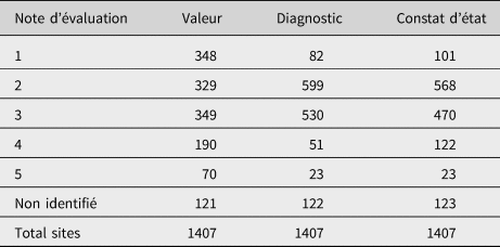
Il est clair que le potentiel archéologique de ces régions montagneuses a différentes valeurs. Tous les points recensés ont été évalués indépendamment des valeurs mentionnées ci-dessus. Plusieurs monuments sont abandonnés et sont dénués de valeurs. Certains présentent une panoplie de valeurs, d'autres montrent des valeurs ajoutées. Une note de 1 à 5 a été attribuée à chaque monument ou site afin de pouvoir distinguer leurs différents niveaux d'importance : plus la note augmente, plus les valeurs se multiplient et/ou sont plus importantes. Les monuments hydrauliques par exemple, tels que les citernes et les puits, ont eu généralement des notes qui ne dépassaient pas 2 au profit des ksour, des citadelles et des monuments qui sont pourvus d'inscriptions ou de décorations rares, des stations d'art rupestre qui sont considérées parmi les plus intéressantes et ont eu des valeurs maximales entre 4 et 5 (Tableau 1).
Répartition des sites selon les notes attribuées (de 1 à 5) pour l’évaluation des valeurs, des menaces et de l’état de conservation.

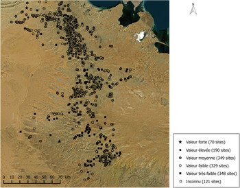
L’évaluation de ces valeurs et leur disproportion ont été enregistrées dans la table d'attributs de QGIS, qui nous a permis de les ressortir sur une carte (Figure 9).
Carte d'évaluation des valeurs (© 2020 Microsoft Corporation, Maxar, CNES, Distribution Airbus DS, Earthstar Geographics SIO).

Diagnostic
Le diagnostic consiste à ressortir les facteurs de détérioration qui pèsent sur le patrimoine archéologique dans ces régions. Cette étape d'identification des menaces est une composante essentielle du processus de gestion. Elle permet de tracer les priorités et d'identifier les sites et les monuments les plus exposés aux facteurs de détérioration.
La nature et la localisation de cette zone dans des régions à haute altitude l'exposaient à de sérieuses menaces. Les images satellitaires ont permis d'identifier plusieurs types de menaces, notamment les menaces anthropiques. Mais aussi, le travail de terrain a joué un grand rôle pour compléter la phase de diagnostic et a pu détecter plusieurs types de menaces notamment biologiques et environnementales qui sont difficiles à identifier à travers la télédétection.
Menaces environnementales
Les facteurs de détérioration environnementale sont multiples vu la nature de l'emplacement des différents sites et monuments. La plus pesante des menaces est l’érosion éolienne. Ces régions sont connues par la formation périodique de forts tourbillons tout au long de l'année, ce qui favorise l'action de l’érosion éolienne qui creuse dans la pierre et provoque sa corrosion.
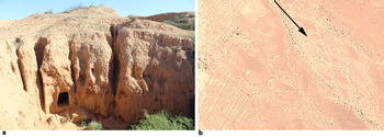
L’érosion hydrique présente aussi un acteur de détérioration, notamment pour les monuments qui se situent au niveau des pentes. Ce type d’érosion a surtout attaqué les monuments troglodytiques. Vu la nature de ces sédiments, l'eau creuse les parois et provoque des fractures (Figure 10) qui peuvent dans certains cas provoquer la détérioration partielle ou totale.
Menace environnementale : érosion. a) Effet de l'érosion sur les monuments troglodytiques, Matmata ; b) image satellitaire qui montre un tumulus affecté par les flux d'oued, Beni Guedal Tataouine.

Le changement brusque de température entre le jour et la nuit et entre les différentes saisons est aussi une spécificité de ces régions. Ce phénomène provoque la dilatation et la contraction de matériaux pierreux et par suite leur altération.
Menaces biologiques
Plusieurs sortes de micro-organismes ont été observés au niveau des structures, tels que des lichens, des algues, des bactéries, des mousses. Parfois la totalité du mur est couverte par des taches vertes, noires ou jaunes.
D'autres aspects de menaces biologiques sont apparents, tels que l'extension de la couverture végétale et l'implantation des plantes sauvages qui colonisent souvent les sols et même les structures.
Menaces animales
Dans plusieurs monuments ont été repérés des trous faits soit par des rongeurs, soit par des animaux sauvages. Le phénomène de pâturage est aussi assez répandu, notamment pour les monuments qui se situent à l'extérieur des villages.
Menaces anthropiques
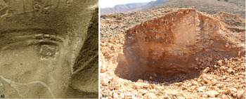
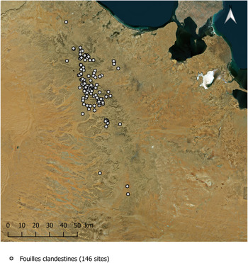
Ce type de menace a été jugé comme le plus néfaste, notamment ces dernières années. L'aspect prééminent de ce type de menace sont les fouilles clandestines. Ces dernières présentent un phénomène qui a atteint son apogée ces dernières années, notamment après la révolution (en décembre 2010). Elles deviennent de plus en plus organisées en l'absence du pouvoir des autorités locales (Figure 11). Le nombre total des fouilles clandestines enregistrées a atteint 146 (Figure 12).
Menace anthropique : fouille clandestine à ksar El Ebarid, Mednine ; a) Image satellitaire 2016 ; b) photo 2019.

Carte de répartition des fouilles clandestines (© 2020 Microsoft Corporation, Maxar, CNES, Distribution Airbus DS, Earthstar Geographics SIO).

D'autre phénomènes sont aussi apparus après la révolution, comme (l'incendie volontaire) ou la démolition des monuments archéologiques religieux par des extrémistes (des islamistes radicaux), en l'occurrence les mausolées. Cette vague de vandalisme a touché des monuments dans notre zone d’étude, tel que le mausolée de Sidi Yakoub à Beni Zelten, et d'autres qui sont à proximité, tels que Sidi Ali Ben Salem à El-Hamma à 15 km de l'extrême nord de notre région d’étude au sud tunisien. En Libye, ce phénomène a touché aussi plusieurs endroits, tels que les mausolées d'Al-Chaab al-Dahmani près du centre de Tripoli, Abdessalem al-Asmar à Zliten, du Cheikh Ahmed al-Zarrouk à l'est de Tripoli, Sidi Mohamed Landolsi à Tajouraont qui ont été détruits à coups de pelleteuse ou par des explosions par des islamistes intégristes en 2012 ou 2013.
L'extension urbaine constitue une autre facette des menaces anthropiques ; elle est assez propagée en Libye comme en Tunisie. Les images satellitaires ont permis d'identifier plusieurs exemples de maisons troglodytes qui avaient disparu au profit de nouvelles constructions.
Le contact avec la population locale a permis de reconnaître d'autres types de menaces anthropiques tels que le vol et le pillage, d'où des collectes systématiques d'objets archéologiques et paléontologiques (des dents et des fragments de squelettes de dinosaures et d'autres animaux actuellement disparus) sont fréquentes.
La qualité inhérente des matériaux
La nature des matériaux de construction a un impact sur la détérioration et la vitesse d'altération. L'exemple le plus frappant concerne les habitations troglodytiques. La nature du sol dans laquelle elles sont creusées est composée d'argile et de sable, ce qui favorise leur détérioration rapide face aux effets de l’érosion que ce soit éolienne ou hydrique.
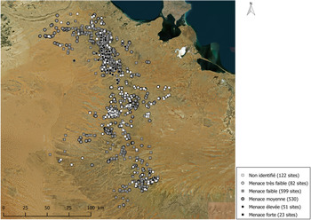
Ces différentes menaces agissent selon différentes intensités et elles ont été déterminées dans notre zone d’étude d'une manière variable. Des valeurs de 1 à 5 ont été attribuées à chaque site et monument afin d’évaluer l'intensité de ces menaces. Par exemple, les sites qui montrent des témoins de menaces environnementales ou anthropiques graves telles que les fouilles clandestines et le vandalisme, ont été jugés comme les plus menacés et on luiattribuait 5 comme note d'évaluation des menaces. En revanche, les sites et les monuments qui ne sont pas soumis à des facteurs de détérioration grave, on luiattribuait 1 ou 2 au maximum (Tableau 1).
Nous avons réalisé la même démarche suivie pour les valeurs et on a ressorti sur une carte, à l'aide de QGIS, le degré de gravité de ces facteurs de détérioration dans les différents sites et monuments (Figure 13).
Carte d'évaluation des menaces (© 2020 Microsoft Corporation, Maxar, CNES, Distribution Airbus DS, Earthstar Geographics SIO).

Constat d’état
L’évaluation de l’état de conservation des vestiges archéologiques a été basée nécessairement sur une évaluation directe ou sur notre connaissance antérieure du terrain pour les monuments qui n'ont pas été visités. C'est rarement qu'on a pu identifier l’état de conservation via les images satellitaires.
L’évaluation de l’état physique des sites et des monuments a permis de distinguer plusieurs sortes d'anomalies. Les monuments souffrent de nombreux types d'altération qui sont récapitulés ci-dessous :
– L'existence de fissures et de fractures superficielles ou structurelles dans la majorité des monuments.
– L'effondrement des plafonds voûtés.
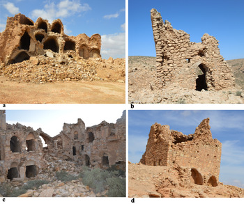
– Destruction des murs, des parties du monument et parfois la démolition totale (Figure 14).
– Déformation de la pierre ou de la structure (Figure 14).
– Dilatation et bombage des murs.
– Perte de pierre, d'enduit et des joints entre les pierres.
– Ecaillement, éclatement ou existence de pores dans les pierres.
– Les traces d'humidité.
– Les traces des sels cristallisés.
– Perte des parties des décors ou d'inscriptions par écaillement.
– Les taches vertes, jaunes ou noires dues aux micro-organismes.
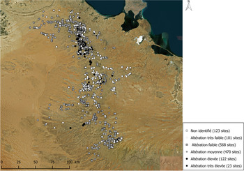
De même, la variation de l’état de conservation du patrimoine archéologique a été enregistrée sur une carte appelée « carte des altérations ». Des valeurs de 1 à 5 ont été attribuées à chaque point afin d’évaluer son état de conservation ; plus la valeur augmente, plus l'altération est importante (Figure 15). La valeur 5 a été attribuée aux sites et monuments qui présentent un état physique très dégradé, tels que ksar El Krachfa, ksar Ezzit, ksar Ouled Mahdi et kasbet Manit à Mednine (Figure 14). Les monuments qui sont en bon état, et qui sont dans la plupart des cas des marabouts, des zaouias, des puits, etc., sont généralement notés entre 1 et 2 (Tableau 1).
Etat de conservation. a) Ksar El Khrachfa ; b) ksar Ezit ; c) ksar Ouled Mahdi ; d) Kasbet Manit (Mednine).

Carte des altérations (© 2020 Microsoft Corporation, Maxar, CNES, Distribution Airbus DS, Earthstar Geographics SIO).

Le plan de gestion
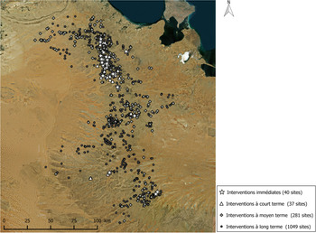
Les informations recueillies lors des visites de terrain ont permis la réalisation d'un plan de gestion et de conservation qui a livré une liste du patrimoine archéologique classé selon un ordre de priorité. La combinaison entre les trois composantes de processus de gestion – valeur, menace et état de conservation – ont permis de planifier les priorités. Cette fusion des données a été faite grâce à QGIS, et a livré quatre niveaux de priorité (Figure 16) :
1. Interventions immédiates : les monuments qui risquent de disparaître sont classés dans cette première catégorie. L'obtention de cette liste a été basée sur le choix des monuments qui sont d'une grande valeurmais très dégradé et qui sont très exposés aux facteurs de détérioration. À ce stade-là, on évoque comme exemple le mausolée de Beni Guedal (Henchir Erroumen) à Remtha Tataouine, un site romain jonché des éléments architectoniques décorés et éparpillés, et qui présente plusieurs fouilles clandestines profondes réalisées par bulldozer. On peut aussi citer l'exemple des arts rupestres de Chaabat El-Maarek et d'Insifri à Ghomrassen qui présentent un témoignage rare de la préhistoire tunisienne, et qui sont soumis à des actes de vandalisme. Plusieurs autres exemples de sites et de monuments sont classés dans cette liste d'urgence du plan de gestion, tels que ksar Ebarid, ksar khrachfa, ksar Ouled Mahdi et ksar Edjaja à Mednine, ksar du village de Beni Guendil à Tataouine, mosquée Ibn Yakhlef à Tounine Gabès, etc. Cette liste comporte au total 40 monuments. Une documentation détaillée et des travaux de consolidation et de stabilisation sont envisagés à ce niveau.
2. Interventions à court terme : cette liste comporte 37 monuments qui nécessitent des interventions de stabilisation dans un intervalle du temps qui ne dépasse pas six mois. Ils sont généralement en mauvais état de conservation et ayant une note égale à 4 dans l’évaluation de leur état physique, de degré d'exposition aux menaces et au niveau de l’évaluation des valeurs. Notons des exemples de sites et monuments à Mednine qui sont classés sous ce niveau de priorité : Kasbet Om Zalay, ksar Ezit, ksar El Harabia, ksar Bou Laswar, observatoire Ghar el Jani, Essmoumnia, etc.
3. Interventions à moyen terme : 281 sites et monuments ont été classés dans cette catégorie. Ce sont ceux qui ont un état de conservation moyen, ne sont pas très exposés aux menaces et sont d'une valeur moyenne. Ils peuvent être des monuments qui sont d'une valeur considérable mais qui sont en bon état de conservation, ou le contraire, qui sont très altérés mais dénués de valeur. Notons comme exemple de cette catégorie la mosquée Bou Hala à Gabès, mosquée les barzaliens, kasbet Jlalta à Mednine, huilerie Matous et ksar Douiret à Tataouine, etc.
Généralement, les interventions suggérées à ce niveau sont la restauration, la consolidation, l'entretien et des mesures préventives.
4. Interventions à long terme : 1049 sites et monuments sont classés dans ce type d'intervention. Ils sont généralement en bon état de conservation et la plupart des interventions programmées sont préventives. La plupart des habitations troglodytiques qui sont dépourvues de décors y sont classés, ainsi que les marabouts qui remontent à la période coloniale, les puits et les points d'eau, etc.
Plan de gestion et de conservation : carte des risques (© 2020 Microsoft Corporation, Maxar, CNES, Distribution Airbus DS, Earthstar Geographics SIO).

Ces différents niveaux de priorité ont été présentés dans une feuille de route. Elle expose les différentes interventions programmées selon différents intervalles de temps (Figure 16).
Conclusion
Les nouvelles technologies telle que l'utilisation de l'imagerie satellitaire a facilité la tâche de documentation du patrimoine archéologique dans une région montagneuse assez étendue. Elle a aussi permis de contrôler l'état de dégradation au fil du temps et déterminer les différentes menaces auxquelles ce patrimoine est exposé. Néanmoins, les travaux de documentation directe par les visites de terrain ont été complémentaires et ont abouti à des résultats plus précis et fiables et ont permis même d'augmenter le nombre de sites découverts par télédétection.
Une fusion entre ces deux méthodes (satellite et visite de terrain) a permis de documenter 2 539 points en Libye, 1 407 en Tunisie, et un total de 3 946 sites archéologiques et monuments historiques dans les deux pays.
Outre le recensement du patrimoine archéologique, un plan de gestion et de conservation de la partie tunisienne a été proposé vers la fin de ce travail. Ce dernier expose une liste des monuments qui nécessitent des interventions classées selon les priorités visant à protéger et conserver notre héritage.
Afin de répondre aux priorités immédiates de ce plan de gestion, nous envisageons un examen analytique des monuments qui font partie de la liste d'urgence. Une documentation, un diagnostic et un examen détaillé de leurs composantes fourniront une liste des interventions précises pour chaque monument.
Remerciements
Les travaux de ce projet ont été soutenus par Global Heritage Fund, J. M. Kaplan Fund, le projet EAMENA (Endangered Archaeology in Middle East and North Africa) et Cultural Protection Fund du Conseil Britannique, dans le cadre des programmes de documentation du patrimoine en péril en Afrique du Nord et au Moyen Orient.
Nous tenons à remercier toutes les personnes qui ont contribué à la réalisation de ce travail. Du côté tunisien, Yassine Lakhal, Ali Thabti, Houcine Hechmi, Lotfi Belhouchet, Karima Benrhaiem, Abdallah Neili, Mohamed Ali Rtimi, Rached Hamdi, Mohamed Zouari, Fethi Guismi et Wafa Ben Dhia. Du côté libyen, nous remercions Muftah Haddad, Abdouraouf Aldarebi, Mousbah Abdelhafidh, Mousbah Esmia, Ahmad Askri et Mohamed Abdelhafidh qui ont participé aux travaux de télédétection et aux visites de terrain. Nos remerciements s'adressent également à toute l’équipe EAMENA, notamment Matthew Hobson et Louise Rayne pour leur support technique, et aux professeurs David Mattingly et Robert Bewley pour leur soutien.
Enfin, je voudrais exprimer ma profonde gratitude à toute l’équipe du projet TIA/TINA qui m'a appris les pratiques de la nouvelle technologie, notamment Anna Leone, Ammar Othman, Will Wootton, Marco Nebbia, Hiba Alkhalaf, Gai Jorayev et Patricia Voke.