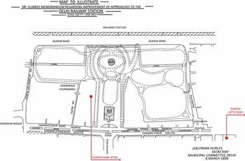
On 18 February 1899, Robert Clarke the deputy commissioner of Delhi and also the president of the Delhi Municipality delivered a memorandum to a select audience of European and Indian municipal members. Clarke, a seasoned official with over 14 years of experience, felt the time was ripe to discuss future municipal plans for the city. Delhi, he began by saying, had ‘risen from the ashes’ after the Rebellion of 1857 to become the ‘capital of India once again, in a different sense from that which it was known to history’.Footnote 1 For Clarke, Delhi, an erstwhile Mughal capital that was stripped of its political status after the Great Rebellion of 1857, had reason to celebrate again for it was now a terminus for the major railway systems in northern India. To him, the railway systems in Delhi were a gift of colonial modernity, a direct cause for the city's prosperity and made it worthy of being re-labelled a ‘capital’ city. However, herein lay the rub for Clarke. It was because of its status as a railway terminus that the ‘interchange of traffic’ in Delhi was becoming a cause for great worry. Although the municipality undertook ‘constant extensions and improvements’, Clarke felt a fool-proof plan for the regulation of railway traffic was urgently required in Delhi.Footnote 2
The appeal by municipal officials like Clarke for urban responses to railway growth presents evidence of how the management of railway traffic was seen as being inextricably linked with the prosperity of Indian cities by the 1890s. As trade in commodities and rail passengers grew at the East India or Central Station at Delhi, it was the local urban agency, the Delhi Municipality, which began debating how the smooth circulation of traffic through the city could be maintained so that the unbounded commercial potential brought by the railways remained secure.
The role of the railways in colonial India has been the subject of extensive historical work.Footnote 3 However, there have been remarkably few attempts to study how urban planning and development in colonial India was influenced by the growth of the railways.Footnote 4 Less still is known about the ways in which the management of traffic arose as an object of state regulation in urban areas as modern forms of locomotion like the railways took root.Footnote 5 This article shows how the question of urban traffic management gained resonance for municipal officials with the expansion of railway networks in north India by the 1890s. It highlights the material impacts of a city being a transport node and the spatial imaginaries that sought to facilitate commerce and flows of capital.Footnote 6 Two interlinked arguments about the relationship between urban planning and traffic management are thus foregrounded. First, the article argues that with the growth of a dense network of railway lines in what were provincial colonial cities like Delhi, municipalities began conceiving of the city as a space where the rate of circulation of commercial traffic was important. If the benefits of the network of railways were to be harnessed for greater commercial opportunities, then it was not just traffic that had to be tackled but the urban fabric, where traffic moved, had to be reconstituted simultaneously. Using Robert Clarke's plan for the Delhi railway station in 1899 as an example of municipal intentions, this article shows how municipal officials began drafting proposals to remedy ‘traffic congestion’ – predicated on the separation of commodity from passenger traffic in the city and re-planned streets and thoroughfares so that obstacles to the flow of traffic were reduced. Yet, as this article argues, such projects went hand in hand with political concerns. While new spaces such as picturesque gardens were to enable circulation in the city, they were also planned to facilitate policing in the vicinity of the railway station and reveal how a politics of difference continued to underpin municipal calculations.
Secondly, this article sheds light on the nature of urban planning in the colonial city by a focus on the contestation between different scales of the state.Footnote 7 As the Delhi Municipality initiated its railway traffic management plans in the 1890s, its designs intersected with the government of India's own intentions for the city. The latter came, for example, in the form of infrastructural works meant to integrate Delhi into a larger political project of territorial consolidation via the railways. The article demonstrates how this overlap between the centralization of authority and the understanding of the urban as a space of circulation, two logics represented by different scales of the state, drove the planning process in the city and its suburban lands. Ultimately, this article suggests that in order to understand the ‘failure’ or ‘success’ of colonial urban plans attention should be paid to the politics of planning and the claims of state power within it.
Delhi, railway space and traffic circulation
The urban transformation of Delhi under colonialism has received considerable attention by scholars. Narayani Gupta's pioneering study on the history of the city over a long dureé provides us with a rich portrait of how Shahjahanabad/Mughal Delhi transformed under British rule, from its takeover by the East India Company in 1803 till its inauguration as an imperial capital in 1931.Footnote 8 Recent historically informed works from perspectives/themes such as architecture, the environment and social geography have done much to complement Gupta's study and added immensely to our knowledge on the development of the city under late colonial rule.Footnote 9 This article, however, differs from previous studies on colonial Delhi on two accounts. First, it addresses a temporal neglect in historiography by focusing on the period of Delhi's political status as a provincial city of the Punjab.Footnote 10 The city was transferred to the latter in the aftermath of the Great Rebellion of 1857 as a political demotion and remained so till the durbar of 1911, the state pageant during which it was announced that the imperial capital would be transferred from Calcutta to Delhi. Secondly, this article approaches the history of Delhi from a political-economic perspective, offering fresh insights into the relationship between its railway development and the reimagining of the city as a space for the smooth circulation of commercial traffic.
A railway station in Delhi was built in the aftermath of the Great Rebellion of 1857 to harness trade prospects between Punjab and Calcutta and to enable government-sponsored relief for famine-struck areas.Footnote 11 However, since the population of the city was deemed complicit in the rebellion, the priority in colonial plans for the railway was also strategic. Unlike in Europe cities, railway lines in Delhi ran right through the heart of the city and divided it into two as an act of punishment. The northern half of the city, a preserve for the European population, was protected by a railway station and lines, which acted as a defensive frontier and could be used to transport troops in case of another ‘mutiny’ from the south.Footnote 12 Thus, the creation of the railway station and lines in Delhi was underpinned by both economic and political considerations and this fitted with the government's larger project of consolidating/cementing its authority over India's territory by the end of the nineteenth century.
Under the aegis of the government of India, the construction of railway sidings and goods stations was rapid, and by the early 1880s, colonial gazetteers boasted that Delhi had become ‘exceedingly well provided’ with railway communications, with no less than three major railways coming into the city itself.Footnote 13 While private companies did indeed expand railway networks in and around cities like Delhi, the shadow of the government of India lingered in matters of supervision and control of railway construction till the end of colonial rule.Footnote 14 This extended to the assignment or allocation of railway land. As Manu Goswami has argued, the control of land or the territorialization of state space was central to the government of India's conception of its own power after the Rebellion of 1857.Footnote 15 The state sought to inscribe itself onto India's territorial space and embed the latter within an imperial political economy. As a result, the creation of railway land and control over railway or ‘state works’ was prioritized and the government of India kept a close watch over the activities of railway companies in the matters of land allocation.Footnote 16
By 1895, in anticipation of Delhi turning into the largest rail terminus – the ‘Charing Cross’ of north India – questions around railway land allocation in the city became the subject of intense scrutiny.Footnote 17 Such was the eagerness for government control of railway networks that orders were passed prohibiting local authorities from allocating land around five miles of Delhi to any railway company without prior sanction of the central government.Footnote 18 Subsequently, land was withheld from being given for the creation of station accommodation in Delhi until the contracts of all major railway companies entering the city were renegotiated in 1900.Footnote 19 The termination of contracts was welcomed as an opportunity, a ‘free hand’ for the creation of a centrally directed and cost-effective scheme for railway accommodation.Footnote 20 Significantly, this was followed by another ambitious proposal in 1898 that government intended to create a larger central station at Delhi – a ‘joint station’ for all future demands of coaching traffic in Delhi.Footnote 21 Indeed, through such designs, the government of India initiated what has been called as the ‘second stage’ in Delhi's railway history.Footnote 22
Rail traffic and the establishment of Delhi as the largest rail terminus, however, brought with it additional questions of circulation, particularly about how the city itself was to be made conducive to the flows of people, goods and commerce. Indeed, the influx of railway traffic was at once a sign of the healthy circulation of commerce but also a source of anxiety for local agencies like municipalities. As the railways grew, cities were inundated with goods carts along with passenger traffic that needed access to the central station or from there to other markets. This was even more so after the 1880s as the railways were slowly beginning to dominate, but not replace, other forms of transport and there was a growing preference for rail usage in terms of both goods and passengers.Footnote 23 With bulk goods heading to and from railway stations, passenger traffic and other modes of transport competing for road space, municipalities like those in Delhi grew increasingly anxious about bottlenecks to flows and movement in the Indian city.Footnote 24 Moreover, as David Arnold has pointed out, there was also a relationship between the discourse of road safety in colonial India and the perception that the ‘unmodern’ bodies of the urban poor were obstacles to traffic circulation. Perceived as lacking ‘road sense’, the presence of such bodies was closely tied to a belief that only stringent government initiatives could discipline traffic.Footnote 25
Clearly, if Delhi was to grow as a large rail terminus and commercial centre, then the rate at which goods and passengers traffic circulated in the city needed regulation with planned interventions minimizing obstacles – both human as well as those of the built environment. Indeed, it was at this scale of urban planning that the Delhi Municipality was to play an important role, as briefly evidenced from Clarke's memorandum at the start of this article.
Separating commodity from pedestrian traffic in the city
The Delhi Municipality and officials like Clarke were all too aware of the need for traffic to circulate smoothly through the city. From the 1860s, municipal policies focused on removing a number of professions and activities labelled as ‘nuisances’ in Delhi on the pretext of their insanitary nature or their obstruction to the circulation of air and movement in the city.Footnote 26 This curbing of ‘bad’ or insanitary practices in urban areas had similarities with developments in the metropolis where urban planners regarded ‘flows, movements and circulation’ necessary for the creation of healthy cities.Footnote 27 However, as historians have suggested, unlike in the metropolis, ‘public nuisance’ provisions under the Penal Code in India tended to criminalize and indict a much larger range of activities than in England.Footnote 28 Thus, in Delhi as elsewhere in India, a ‘discriminatory sanitary order’ prevailed marked by excessive state regulation of the ordinary lives of its inhabitants.Footnote 29
As the government of India deliberated over doubling the size of the central station in the 1890s, the question of traffic circulation came into new light. By this time, two things had become clear to the municipality. The first was that the flow of traffic within the city needed to be regulated, at times moving fast to avoid delays and on other occasions, slowing down to avoid collisions. The second was that interiors of the city had to be reconstituted if railway-associated commerce was to flourish. It was in this light that Robert Clarke delivered his blueprint for the improvement of the Delhi railway station in 1899 (see Figure 1).
‘Clarke's memorandum regarding approaches to Delhi station, 1899’. Dotted lines depict footpaths cutting through Queens Gardens with ‘burj’ in centre. Red dots represent localities of Kuncha Kabuli Attar and Lattu Shah earmarked for 30-foot road clearances.

Clarke and the municipality's scheme rested on the conviction that state-driven planning could re-order the minutiae of urban life, rendering it calculable and predictable.Footnote 30 Significantly, the concern was to remedy ‘traffic congestion’ – the intermingling of pedestrian and heavy goods traffic coming to and from the city. Clarke elucidated this ‘problem’ by stating:
From the railway station gate to the Clock tower, in the Chandni Chauk, the distance is 1,600 feet, but for a passenger to get from one point to the other, either on foot or driving, a distance of 3,200 feet, or exactly double, has got to be traversed, and the only routes are by the Kouria pul and Nai Sarak, both of which are at all hours of the day crammed with goods traffic.Footnote 31
Heavy goods traffic, the argument went, needed separate road connections to the station instead of the two, Kauria Pul and Nai Sarak, which were on either side of the Town Hall (the headquarters of the municipality and its municipal buildings). New roads would cut open the city to ensure that traffic moved seamlessly in straight lines, avoiding what were lamented as the narrow and tortuous paths of the Mughal city. This way, the frequently used lanes through localities like the Dariba were classified as narrow and thus rendered suitable for pedestrian only traffic.
‘Traffic congestion’ was then problematized at two points of entry into the city, the Ajmeri and Delhi gates. The proposals identified that traffic from Paharganj, a suburb of 10,000 inhabitants, entered through the Ajmeri gate of the city but converged with goods and pedestrian traffic coming from the Qutub and Gurgaon directions outside the city. It was lamented that goods carriages were confronted with narrow roads immediately passing through the Ajmeri gate and this prevented them from seeing what lay ahead. A similar case was made for the Delhi gate, which was claimed to require a ‘tolerable’ approach road of about 20–30 yards after the gate.Footnote 32 Thus, the perceived lack of order of Mughal streets, their curvature and irregularity was cited as inimical to the flow of goods and passengers and needing a remedy in the creation of straight approach roads. Clearly, new roads promised to make the space of the city and its traffic ‘legible’ under the gaze of the municipality whilst finally putting an end to the physical and material constraints of Mughal city.
In segregating forms of traffic, a conviction present in the municipal scheme was that the urban fabric had the potential to and could indeed modify behaviour. For example, Clarke pushed for the creation of high footpaths on the new roads that would keep what he called ‘heavy traffic from coming on to light roads’.Footnote 33 Footpaths of course, were not altogether new as a municipal enterprise. However, in context of railway traffic and its management, they had a particular resonance. The emphasis on the creation of ‘high-level’ paths was aimed at disciplining pedestrian and passenger circulation in Delhi. Not only would rail passengers and pedestrians be able to access the station faster but they would also avoid accidents if they were out of the way of goods traffic. This was the rationale behind high-level paths. Roads from this perspective were best kept for carriages, goods carts and animals, i.e. non-human circulation or to borrow Clarke's term, ‘heavy’ traffic.
At specific points, these high footpaths would cut across the municipal gardens – ‘Queens Gardens’ – that lay in between the station and municipal buildings. In effect, the gardens were to draw in pedestrian traffic and thus make circulation problems less acute. Reduced in size, the gardens were to be kept adorned with open flowerbeds and benches along with a mock ruin in the form of an old burj or tower as seen in Figure 1.Footnote 34 Thus, in conjunction with easing congestion and ensuring that pedestrian traffic would be diverted and disciplined to walk on pavements, Clarke's plans also had a pedagogical quality. Pedestrian traffic moving in and around the municipal gardens would instruct and adjust their gaze to focus on a picturesque ruin in a garden setting. As William Glover has argued, across the Anglo-European and colonial world in the nineteenth century, there was a growing belief that material ‘objects’ had the potential actively to shape urban society and mould the sentiments and faculties of individuals.Footnote 35 Material environments, he suggests, served as ‘object lessons’ to induce proper behaviour in colonized subjects ‘tirelessly and persuasively’.Footnote 36 If we look at the placement of the burj in Figure 1, we see that Clarke's ‘ruin in a garden setting’ shows similar concerns. The lesson performed by such an object was to enable the pedestrian to pause and thus regulate movement to enjoy a scene that was based on the seemingly ‘natural’ characteristics of its environment. This ‘object lesson’ was thus to regulate the flow of traffic near the railway station and meant that the direct interference of municipal authorities in disciplining traffic could be reduced. These attributes of the municipal plan focused on turning the existing arrangements near the station and the Queens Gardens into ‘the greatest thoroughfare in Delhi, open at all hours of the day and night’.Footnote 37
Along with the smooth circulation of traffic, the municipal plan appealed to commercial sections in the city by linking their interests to the land market. A fundamental incentive in the municipal scheme was to allow owners of houses near and en route to the station to convert sections of their buildings into business premises. The major commercial markets in Delhi were located either directly in Chandni Chowk or just beyond the Lahore gate of the city to the west. Clarke's plan was twofold: to widen streets at strategic points in certain mohallas (neighbourhoods) that were near the station and, secondly, to stimulate commerce in those lanes just off Chandni Chowk that had benefited from railway expansion in terms of commercial development. By clearing out 30-foot roads in Kuncha Kabuli Attar and Kuncha Lattu Shah, two localities on either side of the municipal buildings in the city (as seen in Clarke's blueprint), it was hoped that the owners of houses would convert some sections of the newly freed area into business premises.Footnote 38 In the case of opening out Lattu Shah, Clarke explained that while business premises were already extending into the lane, they were hampered by the narrowness of the roadway. Thus, as an ‘effect’, the clearances would ‘increase the value of all property facing the new road, and make a frontage of 700 feet as a valuable as an equal length to the frontage in Chandni Chouk’.Footnote 39
The conversion of available space in houses into commercial areas had been a feature after the Mutiny/Rebellion of 1857 where many a haveli (mansion) had been refashioned into more modest structures.Footnote 40 Clarke now hoped that mercantile sections would modify those portions of their dwellings that were on the roads leading up to the station and thus benefit from the rising value of land. The context of the railways was pivotal in this shift and investment in land was closely linked to the development of new commercial hubs.
To keep municipal costs for the scheme low, the proposals were relatively simple. Spare municipal plots in Queens Gardens were earmarked for sale so that space could be made for katras or warehouses. Being near the goods station of the railway, it was hoped that substantial sums could be raised through such sales proceeds.Footnote 41 Significantly, the memorandum also noted that funds did not need to be disbursed in one go. The new roads in Kabuli Attar and Lattu Shah could be introduced gradually, constructing one road in either of the two and leaving it for a couple of years to see if it became a success and then only moving on to experiment with the other.Footnote 42
It has been argued that in drawing maps and plans, the Delhi Municipality sought to freeze the built form of the city, allowing minimum deviation from municipal norms and intentions.Footnote 43 However, the evidence from Clarke and the municipality's traffic scheme above suggests that such arguments of total control need to be qualified further. Clarke's plan did allow, in Foucauldian terms, flows and forms of circulation that were to stimulate commercial activity in the city with a view to the future.Footnote 44 Yet, as with the creation of the railway station and the drive to regulate native ‘nuisances’, a politics of difference too pervaded colonial plans, revealing itself clearly when the question of policing and security near the railway station was problematized.
Planning anxieties and spatial remedies
If municipal designs envisaged the smooth circulation of traffic through the city, Clarke and the municipality's plans are also pronounced in the way they treat the question of colonial difference. This can again be seen from the way Clarke's spatial imaginary envisaged precisely who could move through the newly transformed gardens. As Stephen Legg has suggested, the colonial government was unsure of moving away from a form of governance that focused on ‘dispositions’ of people to one entirely on self-regulating and semi-autonomous ‘processes’.Footnote 45 Similarly, a priority for municipal officials as evinced in the plans was to continue the surveillance of those characterized as ‘thieves and disreputable characters more generally’ from entering the gardens.Footnote 46 For long, the municipality had simply locked the Queens Gardens at night to prevent them from being frequented and therefore sidestepped any concerns over crime and policing. Further, no right of way was given to Indians through the gardens as a wing of municipal buildings adjoined it and where an assembly room was kept for Europeans.Footnote 47 Thus, the entry, opening and closing times were previously regulated and this fitted with intentions to run the gardens as neatly controlled showcases of colonial aesthetic improvement, salubrity and order in the city.Footnote 48
Now, plans for a municipal garden open day and night aroused policing concerns over surveillance, particularly in the vicinity of the busy railway station. The emphasis on ‘thieves and disreputable characters more generally’ in Clarke's address is crucial here for understanding wider colonial concerns over public order in the city, particularly with regard to the movement of the urban poor.Footnote 49 Indeed, itinerant populations exacerbated anxieties in the colonial mind because of perceived linkages between a ‘wandering lifestyle, low social status and criminality’.Footnote 50 However, compounding these fears was the anxiety of another rebellion occurring in Delhi. Clarke had himself argued a few years earlier that policing and, particularly, military presence was of the highest importance in Delhi to keep communication lines open and to overawe the local population.Footnote 51 The consensus amongst Clarke and other officials was that the railway lines and station had to be protected to enable a European military garrison stationed in the erstwhile Mughal Palace (now the Red Fort) to drop down and defend the European quarters in the northern half of the city in case there was another rebellion. While there remained questions about whether the station could eventually double up as a ‘place of refuge’ for Europeans, these debates attest that there was no doubt regarding the strategic purpose of the railways, as a means of retaining political authority and control in the city.Footnote 52 Thus, despite a shift in the understanding of Delhi's place as a commercially viable transport hub from 1890s, there remained fears over the itinerancy of the irrational and dangerous native, particularly in the proximity of the railway station. Clarke's railway plans offered spatial remedies for such issues determining who could move how in the newly transformed gardens and this was to accompany the transformation of the city into a commercial centre buttressed by the management of flows and circulation.
One measure in the plan was to hasten the shift of the assembly room to a ‘new club’ at the Ludlow Castle, a centre of European exclusiveness and sociability. Evidence suggests that this was already agreed upon and Clarke indicated that this would benefit the scheme overall.Footnote 53 This relocation would, as per municipal intentions, eventually remove fears of an intrusion of the native population on European spaces of sociability on a near permanent basis. A second solution was to take railings and gates lifted from the central patri or pavement in Chandni Chowk and use them in the transformed gardens.Footnote 54 The railing-free Chandni Chowk patri would then be able to accommodate a range of sundry trades such as a growing number of cap sellers whose business had grown as a result of the railways. The borrowed railings, in turn, would be installed at strategic points in the new gardens.Footnote 55 With railings all around and gates at certain points enclosing a smaller version of Queens Gardens, ingress and egress was to be more predictable. Indeed, not only would traffic flow smoothly but a smaller version of Queens Gardens made it easier to bring the area under police surveillance with renewed hopes of ‘visibility’. The predictability of movement towards the railway station was thus again important but it must be highlighted that the function of railings and gates differed from that of the burj. While the latter enabled pedestrians to pause and admire a ruin in a garden setting, the strategic placement of railings and gates ensured that colonial concerns around security and native itinerancy were managed. The use of space in Clarke's plans thus constructed and enabled a differentiation between the legitimate users of the garden and railways – such as the commercially inclined native rail users from the likes of ‘thieves and disreputable characters more generally’. The latter was, as has been suggested, intimately linked to a wider colonial anxiety of retaining public order and security in Delhi. Questions of colonial difference therefore, shaped Clarke's railway plans and were inseparable from visions of the city developing into a commercial hub.
Territorialization, circulation and ‘failure’
While the municipality's plans evoked a vision of pinpoint precision ushered to separate forms of traffic and ensure commercial profitability whilst keeping in mind the needs of security, there was, predictably, a gap between intent and effect. This became all too clear when Clarke left the city at the end of his tenure in 1900. The municipality was found wanting when it came to disbursing funds and at first only attempted to alter the width of the city gates. Wide approach roads were created for two, the Ajmeri and Turkoman gates of the city, and a separate entrance for cattle was constructed near the Delhi gate.Footnote 56 However, plans for the much-desired straight roads leading from the railway station to Chandni Chowk were shelved initially and only given a new lease of life as the durbar celebrations of 1902 approached.Footnote 57 Rather than from the point of a long-term benefit to the city, the straight roads from the railway station were thus built for the immediate purposes of imperial power in the spectacle of the durbar. We can perhaps argue, then, that the realization of municipal plans was a disjointed affair and which might, in hindsight, be deemed a ‘failure’.
However, assessing such plans from the point of their ‘success or failure’ in implementation obscures the multiple and overlapping claims of state power that drove colonial ‘planning’ and policy in the first place. It must be highlighted that Clarke's very scheme was an example of how the interaction between different scales of government such as the government of India and the municipality, represented through the logics of territorialization and circulation respectively, could fuel the planning process in Delhi to reorder the city. In this respect, urban ‘planning’ was less about creating what it promised but more about the negotiation of political claims within the state. It was shaped more in response to problems that grew out of the interface between the centralization of state power over land allocation and the need of its agencies to encourage flows and circulation in colonial cities. If at times such overlapping conceptions of state power worked together, on other occasions, they could also work against one another fuelling the planning process. In other words, when scales of state authority with their overlapping but distinct logics of operation and intentions clashed, this had implications for urban planning in Delhi and its suburbs.
An example of where such claims clashed was regarding the allocation of land outside the city walls. In 1903, the government of India on behalf of ADC chord railway gave notice to the Delhi Municipality that a sizeable plot along the Lahore and Ajmeri gates of the city was to be reserved for permanent acquisition at a future date.Footnote 58 Railway companies had been previously allowed to construct crossings and lines outside the gates and this move was in accordance with the government of India's policy of determining how ‘state works’ were to be developed. The municipal authorities, however, intervened to stop the allocation. Instead, they argued that the area in question should be reserved for the municipality, as the latter were trustees of Nazul property and the land was needed for the construction of an over bridge, along with an electric station for future tramways in the city.Footnote 59 Nazul land or ‘government’ properties included an array of plots, roads, cultivated and uncultivated lands that were built upon or unused and ostensibly fell into the hands of the government of India after the Rebellion of 1857.Footnote 60 In the 1870s, the municipality was appointed as a trustee for the maintenance and management of such properties within municipal limits. However, the government of India retained the ultimate right to alienate Nazul properties and directly administered suburban Nazul plots bordering municipal limits outside the city.Footnote 61 At this time, the municipality argued for active charge of suburban Nazul, instead of them being made over again to railway companies, to regulate flows and traffic into Delhi better by the creation of bridge connections between the entrances of the city and tramway installations.Footnote 62 Indeed, through the use of over bridges and city trams, like Clarke's plans a few years earlier, the municipality imagined how urban infrastructure could aid smooth flows of traffic and avoid obstructions like the dense railway grids on the ground. It was clear that circulation would be impeded if further railway construction and thus ‘state works’ were allowed, damaging the long-term economic prospects for Delhi.
Between 1903 and 1909, such municipal protests over the government of India's incorporation of Nazul lands beyond the city gates as ‘state works’ grew louder and more frequent. In 1908, for example, the deputy commissioner and member of the municipality reported that the lack of over bridges and density of railway lines had resulted in long waiting times for rail traffic entering the city via the Farashkhana gate (a smaller entrance between the Ajmeri and Lahore gates).Footnote 63 He argued that the level crossings of the gate which shut 31 times daily with an average closure of 11 minutes, encouraged people to force their way when the gate was shut and this had the potential to increase road accidents and government liabilities.Footnote 64 A now familiar argument that ‘congestion’ – the mixture of goods and human traffic – was claimed to be causing practical difficulties in traffic management near the city gates and needed remedying via municipal intervention and planning.Footnote 65
Municipal appeals were also influenced by the need to keep sections of Nazul land vacant for the purposes of ventilation and sanitation. Indeed, these arguments went hand in hand with the need for traffic management. As mentioned previously, the municipality had for long sought to check the preponderance of activities that were considered ‘nuisances’ to flows, air and circulation. By 1902, the growing network of railway lines had drastically changed perceptions of sanitation and ventilation in the city. With a dense network of railway lines to the north and west of the city and the Yamuna River to the east, the municipality argued that the city was being ‘hemmed’ in and ‘ample space’ was urgently needed for future municipal plans and activities.Footnote 66 If the municipality's focus had for long been the habits of the natives, ironically now the central government's ‘state works’ and concomitant railway technologies were creating difficulties for health and sanitation in Delhi. Without municipal ‘planning’ and intervention, moreover, it was argued that disease and congestion would ultimately stifle the commercial growth in the city. In the case of the Farashkhana gate, the outcome of such tensions between state authorities was profound. In 1908, the government of India backtracked on its plans and gave way for the municipality to create over bridges. What added force to municipal arguments were petitions forwarded to local authorities that the level crossings were beginning to affect religious processions heading to and from Muslim burial grounds to the south-west of Delhi.Footnote 67 The political implications of such developments for a regime concerned with policing and security were perhaps significant in tilting the balance in favour of the municipality. Predictably, however, the municipality felt pinched when considering the financial outlays for over bridge projects but reserved the right to ‘reopen the case of the Farashkhana or the provision of other roads or streets calculated to facilitate communications and traffic in the quarter’ in future.Footnote 68
The point made here is that different scales of government (local urban agencies like the Delhi Municipality and the central government) were imbricated within a politics of planning. Their respective intentions for the city, such as absorption of the city into larger rail networks on the one hand and the understanding of the city as a space of circulation on the other, could clash to drive the process of urban ‘planning’. The allocation of suburban Nazul lands outside the city was one clear example of this.
Conclusion
This article has shown how crucial the growth of the railways was to a re-imagination of colonial Indian cities in the late nineteenth century. As a provincial town in the 1890s, Delhi's future was imagined as a transport node where the smooth circulation of rail traffic was intimately connected with the commercial growth of the city. To remedy ‘traffic congestion’, argued above as the intermingling of pedestrian and goods traffic, local agencies like the Delhi Municipality drafted plans to manage the flows of people, goods and commerce in the city. The urban fabric was to play a key role in this endeavour, with pavements and new garden projects shaping behaviour and movements of rail travellers. Yet, as this article has shown, this spatial imagination was shot through with political concerns and it reveals how a politics of difference underscored municipal plans. New garden plans meant to regulate flows near the railway station on the supposed ‘naturalness’ of the native environment went hand in hand with the relocation of European spaces of sociability and an anxiety over the itinerancy of the native poor. Fears of another rebellion in Delhi and the security of the European population continued to remain important from the municipality's perspective. In such a context, carefully placed gates and railings in new garden plans were also meant to isolate, monitor and facilitate policing so that traffic heading to the railway station could come under surveillance and the latter, in turn, guarded effectively.
Significantly, this article has also used the case of railway development to suggest how a ‘scalar politics’ within the state was constitutive of urban planning in colonial cities. It has demonstrated how the colonial project of territorial consolidation, and thus the inscription state sovereignty, intersected with centrifugal processes of circulation at the level of the city. For the government of India, the city and its outskirts were conceived as part of ‘state works’ and this territorialization of power led it to intervene more directly in urban affairs such as the allocation of land to different railway companies. The claims of local urban agencies like municipality, however, rested on managing circulation, flows and movement in the city. The interaction between the municipality and government of India at times worked together to shape the planning process, such as in Robert Clarke's railway scheme, but on other occasions, as in the case of Delhi's suburban lands, transformed the nature of urban ‘planning’ as a result of tense clashes between their competing logics.