INTRODUCTION
The rich ancient civilisations of central Asia developed under the influence of favourable conditions in the natural environment that may have existed in these areas in previous millennia (Beckwith, Reference Beckwith2011). The water supply and fertile soil developed on loess deposits were conducive to migration and sustained human occupation and served as the primary source of wealth in the early agrarian society that cultivated the land. Loess is common in the marginal zones of the midlatitude central Asian deserts and piedmonts of the Tian Shan and Pamir-Alay Mountains (Dodonov, Reference Dodonov1991, Reference Dodonov2007; Dodonov and Zhou, Reference Dodonov and Zhou2008). In these high mountains are the sources of many rivers that cross the fertile foreland. Central Asia is characterised by extreme continental climatic conditions, which is related to great distance from large water bodies. This feature, along with the presence of high-mountain massifs, creates significant local environmental variability in different parts of the region. Climatic, ecological, and sudden geologic events, common in central Asia, influenced human activity, aiding the development of new economic relationships or bringing on the stagnation or fall of societies (Fan, Reference Fan2010; Baumer, Reference Baumer2014). Modern climate change is evident in central Asia. Similar changes took place in the past, affecting the transformation of the hydrologic regime, the dynamics of the geomorphological processes, and changes in vegetation cover. In recent decades, many studies have aimed at highlighting the long- and short-term consequences of environmental change for human life, migration, agricultural production, and the development and collapse of civilisations (e.g., Hodell et al., Reference Hodell, Curtis and Brenner1995; deMenocal, Reference deMenocal2001; Weiss and Bradley, Reference Weiss and Bradley2001; Haug et al., Reference Haug, Günther, Peterson, Sigman, Hughen and Aeschlimann2003; Sidle et al., Reference Sidle, Taylor, Lu, Adger, Lowe, de Lange, Newnham and Dodson2004; Büntgen et al., Reference Büntgen, Tegel, Nicolussi, McCormick, Frank, Trouet and Kaplan2011; Li et al., Reference Li, Sun, Dodson and Zhou2012; Giosan et al., Reference Giosan, Fuller, Nicoll, Flad and Clift2013; Latore et al., Reference Latorre, Wilmshurst and von Gunten2016; Yin et al., Reference Yin, Su and Fang2016).
The first nomadic and sedentary civilisations in western central Asia, created by the Iranian tribes, lived in the steppe and woodland zone, in the mountain piedmonts covered by loess deposits, and in the oases arising near springs and large rivers (Harmatta et al., Reference Harmatta, Puri and Etemadi1994; Beckwith, Reference Beckwith2011). About 6000 BC, central Asian people improved the regional agrarian economy through farming the land and planting seeds. This provided a great impulse for technological advances, population growth, and the development of town life and of the civilisations between the Pamir and Pamir-Alay Mountains and the Caspian Sea, in the valleys of the Oxus (Amu Darya), Jaxartes (Syr Darya), Zarafshan, and Qashqadaryo Rivers (Dani and Masson, Reference Dani and Masson1992; Ghafurov, Reference Ghafurov2011). Climatic variability and environmental changes over thousands of years forced the inhabitants to innovate and encouraged the development of trade and transportation. This region was crossed by the Silk Road, which played a key role in the history of civilisation, fostering economic, cultural, and religious exchanges between East and West (Baumer, Reference Baumer2014). Ancient urban centres, linked by the various branches of the Silk Road in central Asia, were developed on the basis of efficient agriculture that utilised loess soil and irrigation systems. This socioeconomic association between Silk Road development and loess areas has not been analysed to date from the palaeogeographic point of view. The aim of this study is (1) to analyse the course of the Silk Road branches against the background of the distribution of loess deposits and (2) to analyse the environmental factors that led to the growth and decline of one of the Silk Road’s “loess towns,” ancient Panjikent.
LOESS AND THE SILK ROAD
Loess in central Asia: a general description
Central Asia has been regarded by many authors as one of the classic loess provinces (Dodonov, Reference Dodonov1987, Reference Dodonov2007; Różycki, Reference Różycki1991). Loess formed extensive and thick covers in the foreland of the mountains of this region. The loess of central Asia has been investigated by many researchers, most of them of Russian origin (Obruchev, Reference Obruchev1911, Reference Obruchev1945, Reference Obruchev1986; Fedorovich, Reference Fedorovich1972). The loess areas of central Asia include some of the thickest (up to 200 m) and most important on earth: the loess-palaeosol sequences of Darai Kalon (Dodonov, Reference Dodonov2002), Chashmanigar (Ding et al., Reference Ding, Ranov, Yang, Finaev, Han and Wang2002), and Karamaydan (Bronger et al., Reference Bronger, Winter, Derevjanko and Aldag1995, Reference Bronger, Winter and Heinkele1998; Bronger, Reference Bronger2003) constitute one of the best continental records of Quaternary climate history. Loess sedimentation in central Asia began more than 1 million yr ago, as confirmed by the results of luminescence and palaeomagnetic dating techniques (Dodonov, Reference Dodonov2007). Individual loess horizons measure usually up to 7–10 m in thickness, and palaeosols generally to 5–7 m. The loess horizons were deposited in dry, windy, and cold climate conditions with reasonably high atmospheric dust loadings. Correlation of the Chashmanigar loess-palaesol sequence with Chinese loess supports the hypothesis that the palaeosols in central Asia correspond to interglacial periods, whereas the loess horizons were deposited during glacial periods (Ding et al., Reference Ding, Ranov, Yang, Finaev, Han and Wang2002). Thus, the central Asia loess province belongs to a unique area characterised by almost continuous loess deposition during the Quaternary period. The process of wind-borne dust transport and deposition is still active in central Asia, as confirmed by the great frequency of dust storms in this region (Róźycki, 1991; Goudie and Middleton, Reference Goudie and Middleton2006).
Loess deposits in Tajikistan occur in the western and southwestern piedmont zones of the Pamir and Pamir-Alay Mountains (Mirzobaev et al., Reference Mirzobaev, Zubarev, Ismailov, Musaelyan and Romanov1968). They form large patches, which often continue along the mountain river valleys and cover higher terraces. Loess accumulation in Tajikistan is closely related to the geographic, atmospheric, and climatic conditions in this part of central Asia (Ding et al., Reference Ding, Ranov, Yang, Finaev, Han and Wang2002). The great midlatitude deserts, Karakum and Kyzylkum, are situated directly to the west and northwest of the loess region, bounded on the east by the high mountains of the Pamir region. The extensive deserts provide the loess regions with a large quantity of aeolian dust. However, it should be noted that the sources of dust may vary in this physiographically diversified region. Deposits of Tajik loess can be found in various geomorphic locations, which may indicate their varied genesis. The thickness of the loess cover reaches from 30 to 50 m in the Pamir-Alay foreland to 200 m in southwestern Tajikistan (Markovsky, Reference Markovsky1959; Goudie et al., Reference Goudie, Rendell and Bull1984; Shackleton et al., Reference Shackleton, An, Dodonov, Gavin, Kukla, Ranov and Zhou1995; Ding et al., Reference Ding, Ranov, Yang, Finaev, Han and Wang2002)
The course of Silk Road branches and loess patches in central Asia
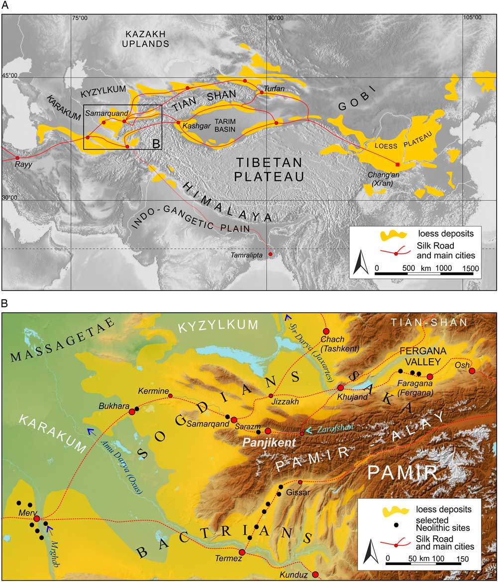
Located between China and Europe, central Asia played a huge role in the transit of trade following the development of the first agricultural societies and urban settlements. In the second century BC, the road had only two branches in central Asia (Harmatta et al., Reference Harmatta, Puri and Etemadi1994; Litvinsky et al., Reference Litvinsky, Zhang and Samghabadi1996), but in the succeeding centuries, a system of main and supplementary roads developed, connecting every oasis and state. The peak of the road’s prosperity occurred during the Tang dynasty, in the second part of the first millennium AD. Because of political factors and environmental changes, the routes shifted, but the main road system and its principal course remained unchanged (Litvinsky et al., Reference Litvinsky, Zhang and Samghabadi1996; Baumer, Reference Baumer2014). From the fifth to the seventh century AD, several main roads ran through central Asia (Fig. 1A). The northern road led along the northern edge of the Tian Shan Mountains; the middle road crossed the Turfan Depression and the northern rim of the Tarim basin in the direction of the Fergana Valley. These branches joined in Samarkand and continued through Bukhara to Merv. The southern branches of the road ran along the southern rim of the Tarim basin, through Kunduz, and then along the Oxus (Amu Darya) River in the direction of Merv, where most of the main roads converged. Then, the road ran along the southern edge of the Karakum Desert towards the Caspian Sea, the Caucasus, and the Black Sea to Asia Minor and Byzantium (Fig. 1A).
(colour online) (A) Schematic map showing distribution of loess and loesslike deposits in central Asia and main branches of the Silk Road (modified after: Dodonov, Reference Dodonov2007; Dodonov and Zhou, Reference Dodonov and Zhou2008). (B) Location of ancient Panjikent in central Asia; the main Neolithic protourban and urban settlements and names of Iranian tribes are also placed (modified and supplemented after: Dani and Masson, Reference Dani and Masson1992; Harmatta et al., Reference Harmatta, Puri and Etemadi1994).

The Silk Road in central Asia ran through areas characterised by very difficult natural conditions consisting of high mountains and deserts. Obstacles were presented by the Karakum Desert, the Taklamakan Desert, and the Pamir-Alay and Pamir Mountains (Fig. 1A). In the face of these difficulties, travel was possible only thanks to a network of towns and settlements. Favourable geographic factors unique to this area, such as abundant water (oases, rivers) and fertile loess soils, influenced the development of this network. From Chang’an (Xi’an) to the Caspian Sea, the route clearly coincided with loess areas, where many settlements based on agriculture were erected. The largest Silk Road towns in western central Asia, such as Merv, Bukhara, Samarkand, Chach (Tashkent), and Panjikent, developed in the marginal parts of Taklamakan and Karakum, which are covered by loess (Fig. 1A). Two branches of the road ran through the loess on the margin of the Taklamakan Desert and joined the Kashgar loess patch. The northern branch of the Silk Road led to the northern limits of the Tian Shan Mountains and the Kazakh loess.
STUDY AREA
General settings and climate conditions
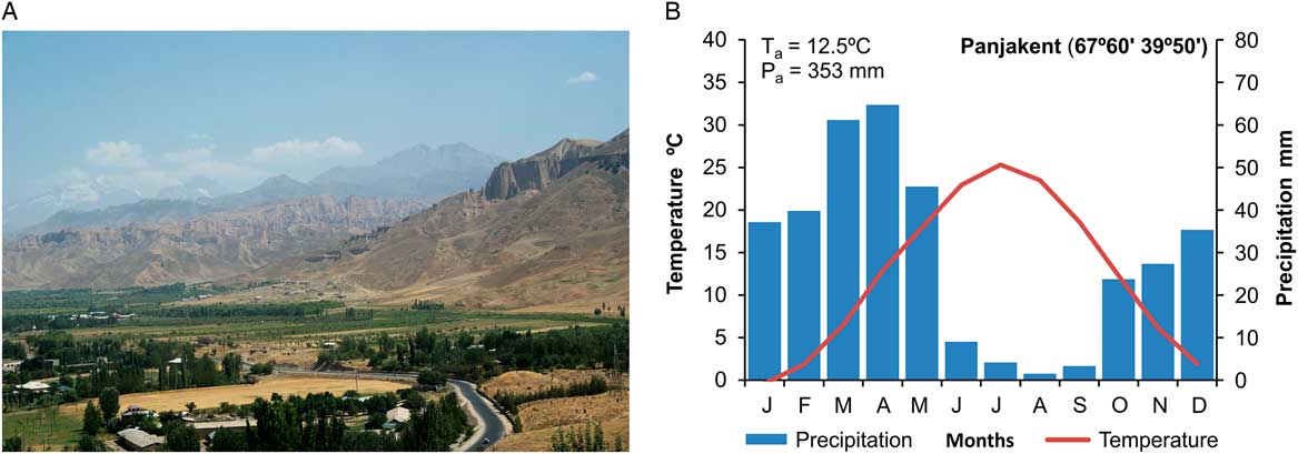
The ruins of ancient Panjikent are located in the southern periphery of the modern city of Panjakent in northwestern Tajikistan in the Pamir-Alay Mountains on the left bank of the Zarafshan River (Fig. 1B). This region is characterised by typical high-mountain relief, including steep slopes with numerous traces of mass movement. Small valley and cirque glaciers are situated in the highest part of the mountains. The latitudinal Zarafshan River valley divides the western Pamir-Alay Mountains into two parts: the Turkestan and Zarafshan ranges, with elevations reaching more than 5000 meters above sea level (m asl). The analysed area is situated in the area where the Zarafshan River flows from the Pamir-Alay Mountains towards two extensive central Asian deserts, Kyzylkum and Karakum. In the vicinity of Panjakent, the valley is 3.6 km wide (Fig. 2A).
(colour online) (A) General view of the Zarafshan River valley in the vicinity of ancient Panjikent. (B) Climatic diagram for Panjakent meteorological station (1016 m above sea level). Ta, average annual temperature; Pa, average annual precipitation total for the period 1931–1990 (after data of Williams and Konovalov [Reference Williams and Konovalov2008], partly updated). Photo credit: Piotr Owczarek.

Tajikistan lies on the border of temperate climate (the northern part of the country) and subtropical climate (the southern part) zones. Its climate is characterised by distinct continental features: aridity, abundant heat, and significant diurnal and seasonal fluctuations in temperature. According the Köppen-Geiger climate classification (Kottek et al., Reference Kottek, Grieser, Beck, Rudolf and Rubel2006; Peel et al., Reference Peel, Finlayson and McMahon2007), Panjakent is characterized by typical temperate climate with dry and hot summer (Csa type). In Panjakent, mean annual temperature reaches 12.5°C. Average monthly temperature varies from −0.4°C in January to 25.3°C in July. The annual temperature range (25.7°C) is typical for the moderate continental regions. Another feature is low humidity and low rainfall, which in this area is 353 mm (Fig. 2B). Much of it falls during the spring period; winter is generally characterised by a small amount of snow (Williams and Konovalov, Reference Williams and Konovalov2008).
In the area of the central Asia, dominant wind directions are characterised by definite seasonality, from southeast in winter to northwest in summer. This is mainly because of changes in the primary drivers of circulation during winter and summer. The easterly winds in winter are products of the southwestern periphery of the Asiatic High, and northwesterly winds in summer are associated with the eastern periphery of the Azores High. However, individual mountain ranges distort the airflow, setting up many local circulations. Thermal and dynamic differences connected with great differences in relief produce characteristic winds of local origin that are known by particular names. The seasonal variability of wind directions is particularly pronounced in the Zarafshan valley. In accordance with the general orientation of this valley, easterly winds dominate, blowing from top to bottom of the valley (Lydolph, Reference Lydolph1977).
Geology and loess characteristics
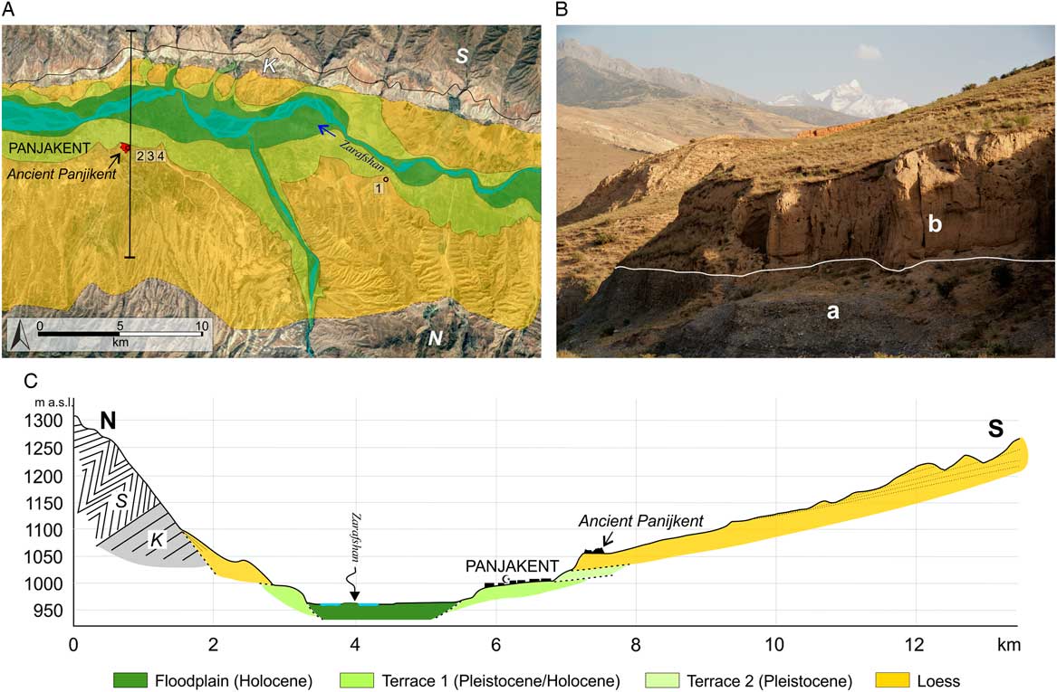
The Pamir-Alay area was finally uplifted during the Alpine orogeny, but neotectonic processes can be observed. This region is characterised by high seismicity, connected with its location in the vicinity of the Pamir frontal thrust system (Lukk et al., Reference Lukk, Yunga, Shevchenko and Hamburger1995; Schurr et al., Reference Schurr, Ratschbacher, Sippl, Gloaguen, Yuan and Mechie2014; Owczarek et al., Reference Owczarek, Opała-Owczarek, Rahmonov and Mendecki2017). The geologic structures mainly include Upper Palaeozoic and, to a lesser extent, Carboniferous, Cretaceous, and Neogene rocks (Vlasov et al., Reference Vlasov, Dyakov and Cherev1991; Vinnichenko and Tadzhibekov, Reference Vinnichenko and Tadzhibekov2010). The Zarafshan River is characterised by a typical braided channel pattern, with numerous islands and side and central bars (Fig. 3A). Two distinct visible morphological units can be distinguished in the valley bottom: a wide Holocene level, which at present is being shaped by the fluvial processes, and a Pleistocene/Holocene terrace located about 40 m above the river channel, where modern Panjakent is located (Fig. 3A and C). Higher Pleistocene glaciofluvial levels and slopes built of older rock formations are covered by loess to a thickness of 30–40 m (Mirzobaev et al., Reference Mirzobaev, Zubarev, Ismailov, Musaelyan and Romanov1968). The remains of ancient Panjikent are located on the edge of an older fluvial terrace with loess cover at an elevation of 1055 m asl (100 m above the modern Zarafshan River channel) (Fig. 3B). This loess cover is dissected by many gullies and flat-floored dry valleys, which typically occur in complex systems. Alluvial fans characterised by different sizes and traces of mud flows are typical elements of these systems. The depth of the gullies and valleys ranges from 20 to 50 m. Both deep and shallow landslides, formed in loess sediments, are common in the analysed area.
(colour online) (A) Outline geology of the Panjakent area (K, Cretaceous; N, Neogene; S, Silurian; 1, 2, 3, 4, location of sampling points). (B) Geologic structure of the higher Pleistocene terrace (a, fluvial deposits [gravel, sand]; b, loess [undifferentiated]). (C) Schematic cross section through the Zarafshan River valley (modified after: Markovsky, Reference Markovsky1959; Vlasov et al., Reference Vlasov, Dyakov and Cherev1991). Photo credit: Piotr Owczarek.

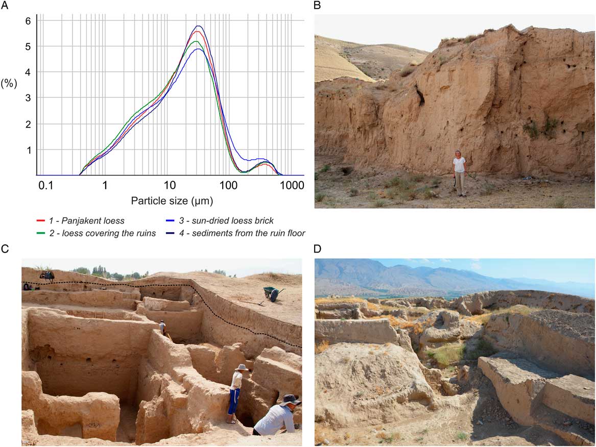
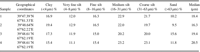
Four samples of loess material were taken in order to determine a basic lithological property—namely, grain-size distribution (Figs. 3A and 4A). The performed analysis enabled preliminary recognition of the loess grain size close to the archaeological site. The number of collected samples was limited because of ongoing archaeological work; therefore, samples were taken only from sites representative of the entire complex. All samples were analysed with a laser particle sizer (Mastersizer 2000). Samples were analysed in wet dispersion using an ultrasonic vibrator for 5 minutes. Before the measurement, organic matter was removed by H2O2, and carbonates were removed by 10% HCl. Sodium hexametaphosphate (Calgon) was added to the solution before measurement. Sample 1 was taken from the last glacial loess unit, the outcrop of which is located about 15 km east of the ancient city (Fig. 4B), and sample 2 was taken from the aeolian loess covering the eastern part of the ruins (Fig. 4C). Both the third and fourth samples are parts of ancient Panjikent: sample 3 is a sun-dried loess brick, whereas sample 4 was taken from the floor of the ruins of a building situated in the southeastern part of the ancient town complex (Fig. 4D). The results of granulometric analyses are shown in Table 1. In general, the results of grain-size analysis are similar to the limited data presenting Tajik loess in the literature (e.g., Goudie et al., Reference Goudie, Rendell and Bull1984; Dodonov, Reference Dodonov1987, Reference Dodonov2002, Reference Dodonov2007; Mestdagh et al., Reference Mestdagh, Haesaerts, Dodonov and Hus1999; Ding et al., Reference Ding, Ranov, Yang, Finaev, Han and Wang2002; Vandenberghe et al., Reference Vandenberghe, Renssen, Van Huissteden, Nugteren, Konert, Lu, Dodonov and Buylaert2006; Vandenberghe, Reference Vandenberghe2013). They confirm preliminary conclusions published by Goudie et al. (Reference Goudie, Rendell and Bull1984) that the loess of Tajikistan is finer grained than most loess from other parts of the world. Median grain size in loess horizons usually varies between 10 and 16 µm, whereas substrate of soil horizons is significantly finer (Ding et al., Reference Ding, Ranov, Yang, Finaev, Han and Wang2002).
(colour online) (A) Grain-size frequency curves of loess samples from Panjakent area. (B) Loess exposure near the ruins of the ancient Panjikent (sample 1). (C) Ruins of the ancient Panjikent covered by loess deposits (sample 2). (D) Remains of buildings of the ancient city built of sun-dried brick (samples 3 and 4). Photo credits: Piotr Owczarek, Magdalena Opała-Owczarek.

Percentage of the grain-size classes and median size of Panjakent loess samples.

All analysed samples are characterised by similar grain-size distribution curves (Fig. 4A). The Panjikent loess is predominantly silty, with a median grain size in the range of 16.3–20.5 µm. Medium and coarse silt fractions are dominant, with a high content of particles smaller than 16 µm (>40%), suggesting aeolian transport over great distances. On the other hand, a significant amount of sand (9.5–15.6%) suggests the substantial role of local sources most probably connected with the Zarafshan River valley. Loess in sample 2, deposited during the historical period after the fall of the ancient town, has the finer-grain-size distribution than other samples. This is a typical feature of loess that has been deposited in a warm climate phase (Ding et al., Reference Ding, Ranov, Yang, Finaev, Han and Wang2002; Nugteren et al., Reference Nugteren, Vandenberghe, Van Huissteden and An2004; Vandenberghe et al., Reference Vandenberghe, Renssen, Van Huissteden, Nugteren, Konert, Lu, Dodonov and Buylaert2006).
The similarity of grain-size distribution of all analysed samples indicates that ancient Panjikent was built from local loess material. The increased content of sand in sample 3 may suggest the incorporation of fluvial material in brick production.
GROWTH AND DECLINE OF ANCIENT PANJIKENT
Historical and archaeological setting of Panjikent
Ancient Sogdiana included the territories between the Oxus (Amu Darya) and Jaxartes (Syr Darya) Rivers, of which the central part was the Zarafshan River basin with the cities Bukhara, Samarkand, and Panjikent. This area has a rich history; as early as in the Bronze Age, Sogdiana possessed an urban culture. In the second part of the sixth century BC, Sogdiana became part of the Achaemenid, or First Persian Empire. Alexander the Great conquered this area at the beginning of the fourth century BC, and Sogdiana fell under the influence of Hellenic culture. This central Asian urban civilisation reached its greatest prosperity during the golden age of the Silk Road, which started in the fifth and sixth centuries AD (Litvinsky et al., Reference Litvinsky, Zhang and Samghabadi1996; Marshak, Reference Marshak2003).
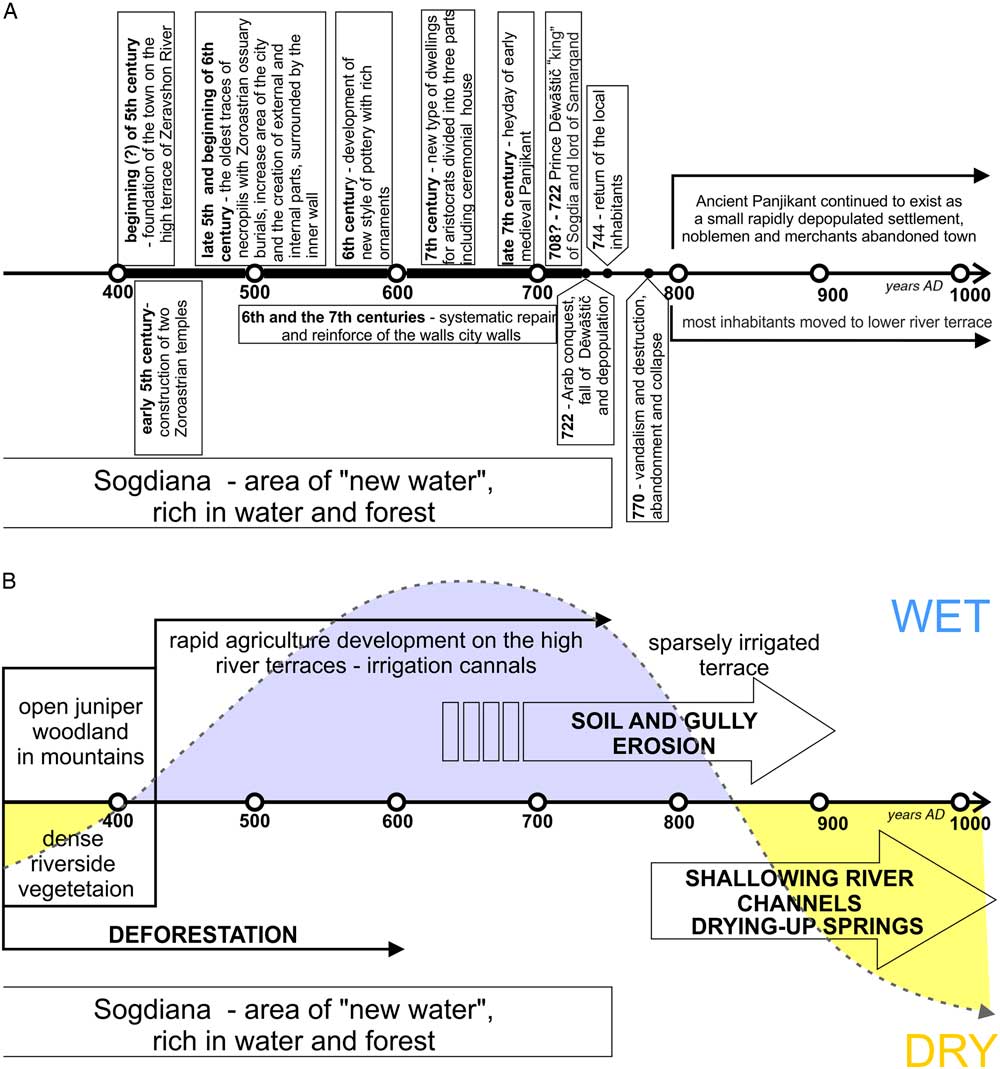
During the fifth century, the population of the country increased rapidly. At this time, a new urban centre, Panjikent, was established (Fig. 5A) (Belenitskii, 1981; Marshak, Reference Marshak2003, Reference Marshak2016). The site where the city was established was surrounded by woodland. The presence of springs enabled the development of agriculture in the fertile loess soils. The city was built on the branch of the Silk Road that ran along the Zarafshan River valley and connected the Samarkand oasis with the Fergana Valley (see Fig. 1). The extensive ruins of the ancient town, located on the edge of the high Zarafshan River terrace, are covered by loess deposits 30 m thick. The ruins consist of the remains of the citadel, separated by a ravine from the city proper and surrounded by fortified walls. In the fifth century, these city walls of Panjikent were 10–11 m high and, like the residential buildings, were made of sun-dried brick from the loess deposits (Semenov, Reference Semenov1996; Marshak, Reference Marshak2016). The bricks were composed of local loess material, as confirmed by granulometric research (see Fig. 4). The city was built on a regular plan, including two-story houses and Zoroastrian temples richly decorated with murals and wood carvings. The area of the city, about 8 ha at the beginning of the fifth century, nearly doubled over the next hundred years. The rapid development of the city and construction of the new city wall influenced the division of the town into inner and outer quarters. At the foot of the town lay the lower fortification, with traces of a moat filled in ancient times by water supplied from the abundant Qaynar spring (Marshak, Reference Marshak2016). Early mediaeval Panjikent enjoyed its heyday at the end of the seventh century, at which time the passageways between neighbouring buildings were partly covered with vaults, and the two-story residential houses, not only those of rich inhabitants, were richly decorated (Belenitskii et al., Reference Belenitskii, Marshak and Raspopova1979; Marshak, Reference Marshak2003). The city’s location on the Silk Road led to the rapid development of trade and crafts. Situated along the streets, in the lower parts of residential houses, were the shops and workshops of jewellers, blacksmiths, and other metalworkers (Raspopova, Reference Raspopova1980). Archaeological excavations and finds (e.g., coins) indicate that these commercial zones were a melting pot where local merchants met others hailing from a wide range of areas, from China to Byzantium. The abundance of coins, minted in the seventh century in various centres, indicates the rapid growth of retail trade between regional settlements and Silk Road cities (Marshak, Reference Marshak2003). The huge importance of the town in the kingdom of Sogdiana at the turn of the seventh and eighth centuries confirmed documents found at the top of Mt. Mug (Moḡ) (Livshits, Reference Livshits1962; Bogolyubov and Smirnova, Reference Bogolyubov and Smirnova1963). Dēwāštič, the ruler of Panjikent at this time, claimed the title “king of Sogdiana and lord of Samarkand” (Grenet and de la Vaissière, Reference Grenet and de la Vaissière2002; Bloom and Blair, Reference Bloom and Blair2009). This title indicates that Panjikent was the most important city in Sogdiana at this time. The Arab conquest in AD 722 did not cause its definitive collapse (Fig. 5A). Sogdiana became one of the richest parts of the caliphate, and the rapid growth of Samarkand and Bukhara ensued. However, Panjikent gradually lost its importance; during the ninth and tenth centuries, it continued to exist, but as a small town (Marshak, Reference Marshak2003). The abandonment of the town during this time did not mean the end of ancient Panjikent. The inhabitants moved from the high terrace to the lower level of the Zarafshan River valley, where a new settlement, present-day called Panjakent, was founded (Fig. 5A) (Marshak, Reference Marshak2016).
(colour online) (A) Time scale of the of the rise, development, and collapse of ancient Panjikent on the basis of written sources and archaeological research (modified and supplemented after: Belenitskii et al., Reference Belenitskii, Marshak and Raspopova1981; Marshak, Reference Marshak2003, Reference Marshak2016). (B) Environmental and landscape changes in the vicinity of ancient Panjikent (the schematic curve of climate change was compiled and modified after: Yang et al., Reference Yang, Wang, Bräuning, Dong and Esper2009, Reference Yang, Qin, Wang, He, Melvin, Osborn and Briffa2014; Chen et al., Reference Chen, Chen, Holmes, Boomer, Austin, Gates, Wang, Brooks and Zhang2010; Opała-Owczarek et al., Reference Opała-Owczarek, Niedźwiedź, Owczarek and Rahmonov2017).

Environmental and landscape changes in the vicinity of Panjikent
Advantageous environmental conditions enabled the development of ancient Panjikent. Water was abundant, and the friable loess proved readily tillable for the settlers. The development of settlements in the Zarafshan River valley was also influenced by the abundance of wood from riverside and mountain juniper forests (Fig. 5B). The vicinity of ancient Panjikent has been intensively cultivated for almost 1500 yr, at least since the town’s foundation. However, earlier phases of agricultural expansion and regression occurred in this area, including land clearance and reforestation. The development of the town and its peak prosperity in the sixth and seventh centuries coincides with the improvement of climatic conditions (Fig. 5B). During those times, the climate was milder and more humid (Yang et al., Reference Yang, Wang, Bräuning, Dong and Esper2009, Reference Yang, Qin, Wang, He, Melvin, Osborn and Briffa2014; Pei and Zhang, Reference Pei and Zhang2014). Pressure because of population growth led to rapid deforestation and expansion of cultivated land, causing an increase in the intensity of erosion processes. As a result, soil was washed downslope, destroying the irrigation system, and gullies were incised and widened. The humid climate in the seventh century, noted on the basis of proxy records, was capable of simultaneously influencing an increase in the intensity of gully erosion rates and losses and reductions of cultivation area (Fig. 5B). These losses may also have been related to the exploitation of loess by brickyards and the production of bricks used for the construction of new houses, utility buildings, and repair of the defensive walls. The Arab conquest of the city did not cause its collapse, but the city’s importance declined significantly, a trend that should be associated with the slow collapse of agriculture because of negative anthropogenic environmental changes. The abandonment of the town took place in the ninth century, when the inhabitants moved to the lower river terrace, watered by several springs and directly irrigated by water from the Zarafshan River. The drying up of the springs influenced the reduction of cultivation in fields located on slopes above the town. Movement of the residents was closely related to the drying-out period, which in this part of central Asia began at the beginning of the ninth century (Fig. 5B) (Esper et al., Reference Esper, Schweingruber and Winiger2002; Yang et al., Reference Yang, Wang, Bräuning, Dong and Esper2009). An increase in the intensity of aeolian processes took place during the dry periods, and the abandoned settlement was covered by loess to a thickness of 1–1.5 m.
DISCUSSION
Climatic, environmental, and socioeconomic changes are well known, especially over the past 2000 yr (Pages 2k Consortium, 2013; Pei and Zhang, Reference Pei and Zhang2014). In recent decades, proxy records from central Asia have been derived from ice cores, tree rings, archaeological data, lake sediments, and glacier fluctuations. Palaeoclimatic reconstructions have enabled scientists to describe the full range of natural climate variability in the context of the past two millennia (Yang et al., Reference Yang, Wang, Bräuning, Dong and Esper2009; Chen et al., Reference Chen, Chen, Holmes, Boomer, Austin, Gates, Wang, Brooks and Zhang2010; Opała et al., Reference Opała, Niedźwiedź, Rahmonov, Owczarek and Małarzewski2017).
Existing hydroclimatic reconstructions show that in arid central Asia, three humid periods (AD 0–410, 650–890, and 1500–1820s) and two dry periods (AD 420–660 and 900–1510) have occurred over the last 2000 yr (Yang et al., Reference Yang, Wang, Bräuning, Dong and Esper2009). In general, negative correlations between temperature and precipitation dominate, suggesting that temperatures were above (below) average when dry (wet) conditions predominated in this region. Various records show similar low-frequency trends, indicating large-scale events occurring in central Asia (Yang et al., Reference Yang, Wang, Bräuning, Dong and Esper2009). Many local studies show that during the so-called Mediaeval Warm Period recorded in the ninth to the twelfth centuries, an anomalously dry and warm climate occurred. The beginning of this period coincides with the abandonment of ancient Panjikent and the founding of the new settlement on the lower river terrace. An earlier drought period, which took place in the fifth and sixth centuries, had led to the collapse of many important cities along the Silk Road. This period coincides with the abandonment of, for example, Niya and Loulan in the Tarim basin (Litvinsky et al., Reference Litvinsky, Zhang and Samghabadi1996). Long-term drought, lasting at least two centuries and forcing the nomadic migration in central Asia (Pei and Zhang, Reference Pei and Zhang2014), influenced an increase in wind erosion, whereby the shallow rivers and lakes in the Taklamakan oasis would fill with windblown dust and thus change their course. This dry period, AD 420–650, extended to arid central Asia (the Tibetan Plateau, central Mongolia, and the Jaran and Tengger Deserts) (Chen et al., Reference Chen, Shi and Wang1999; Fowell et al., Reference Fowell, Hansen, Peck, Khosbayar and Ganbold2003; Sheppard et al., Reference Sheppard, Tarasov, Graumlich, Heussner, Wagner, Osterle and Thompson2004; Pei and Zhang, Reference Pei and Zhang2014) and eastern China (Yang and Shi, Reference Yang and Shi2001; Yang et al., Reference Yang, Wang, Bräuning, Dong and Esper2009). Similarly, the droughts that began in the ninth century may have been responsible for the collapse of the Tang dynasty (AD 907) (Su et al., Reference Su, Liu, Fang and Ma2016). Droughts that occur against the background of a dry climate may have especially great impacts on societies, whereas droughts occurring against the background of a wet climate may have weaker impacts on socioeconomic conditions (Tan et al., Reference Tan, Cai, An, Yi, Zhang and Qin2011).
The growth and decline of ancient Panjikent and other important towns along the Silk Road are strongly connected with natural conditions. Humid periods favoured irrigation and agriculture in the fertile loess soil, and thus rapid urban development. On the other hand, population pressure led to deforestation and expansion of cultivated land; consequently, erosion processes caused by water and wind increased. Declines in natural and agricultural resources because of human and, subsequently, climatic forces may have caused the fall of ancient Panjikent. Human-induced soil erosion accelerated by drought periods at the end of the first millennium AD, which led to social crisis, is well documented in different loess areas in China (e.g., Derbyshire, Reference Derbyshire2001; He et al., Reference He, Zhou, Zhang and Tang2006; Wang et al., Reference Wang, Shao, Wang and Gale2006; Fan, Reference Fan2010).
CONCLUSIONS
The Silk Road branches in central Asia are closely related to the occurrence of loess cover. From Chang’an (Xi’an) to the Caspian Sea, the course of the road clearly coincides with loess areas, where many settlements were erected on the basis of the presence of fertile loess soil and the abundance of water from mountain springs and snowmelt. Loess is common in the marginal zones of the central Asian deserts and mountain piedmonts of Tian Shan and Pamir-Alay.
The peak of the road’s prosperity occurred during the Tang dynasty in the second part of the first millennium AD. During this time, trade was conducted mainly by Sogdian merchants, who lived in Sogdiana, a fertile land located in the western Pamir-Alay Mountains and their foothills. One of the towns erected along the Silk Road in the fifth century was Panjikent, which by the end of the seventh century had become the most important urban settlement in Sogdiana. The city was founded on the basis of rich natural resources: gentle slopes covered by loess, abundance of wood, and access to water from streams flowing down from the mountains. The ancient town was abandoned in the ninth and tenth centuries. The similarity in the grain-size distribution of all analysed samples of loess material, both from outcrops and sun-dried brick, indicates that ancient Panjikent was built from local loess material.
The fall of ancient Panjikent was associated with more than just a political crisis. Traces of large-scale gully erosion suggest a decline in natural and agricultural resources because of human impact and the town’s gradual decline in importance. A period of drought near the end of the first millennium influenced the final abandonment of the ancient town and its relocation to the lower terrace of the Zarafshan River.
ACKNOWLEDGMENTS
The authors wish to thank local people from Ayni and Panjakent Districts for their help and hospitality. The research was supported by the Polish National Science Centre (NCN) (Grant No. 013/09/B/ST10/00634, “Comparison of thermal variability during the last millennium in the mountains of Central Asia and Central Europe”). Our thanks are due to Randall J. Schaetzl and Nicholas Lancaster and two anonymous reviewers for their constructive comments that greatly improved the balance and clarity of the paper.