INTRODUCTION
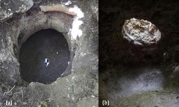
Chultunes (underground pits carved into bedrock; Figures 1a–1b) are relatively simple creations when compared to the plethora of majestic monumental architecture created by the ancient Maya. However, these ubiquitous subterranean constructed features remain a mystery and have long fascinated archaeologists. Chultunes were used from the Middle Preclassic into the Late Classic period, between 1000 b.c. and a.d. 850, and are most common in the Yucatán peninsula (northern Maya lowlands). They are also present in the southern Maya lowlands in the region of Petén, Guatemala, and Belize (Calderon and Hermes Reference Calderon, Hermes, Laporte, Arroyo and Mejía2005; Dunning Reference Dunning1992; Scarborough et al. Reference Scarborough, Becher, Baker, Harris and Valdez1995; Smyth et al. Reference Smyth, Perramon, Zapata and Farrell1998). Although subterranean chambers (known as botellones or bell-shaped pits) have also been reported in the Maya highlands, El Salvador, and highland Mexico (Marroquin Reference Marroquín Franco2006; Winter Reference Winter and Flannery1976), the focus here is on chultunes identified in the southern Maya lowlands.
(a) Mouth of the chultun; (b) view from inside a one-chambered chultun, looking towards the entrance. Photographs by the author taken at El Perú.

What makes these features appealing is their functional, not architectural, complexity and their possible meaning to the ancient inhabitants of this region. As modern-day Maya do not use chultunes (Puleston Reference Puleston1965), archaeologists have to rely on excavations and historic records to piece together possible functions and meaning. Archaeologically speaking, hundreds of chultunes have been located but not all have been excavated. The debate on their principal use continues to this day, with a range of hypotheses proposed since their discovery. Due to the lack of solid data to support one hypothesis versus another, scholars have reached a point where it has become simpler to argue that they were multi-purpose (Pinto and Acevedo Reference Pinto, Acevedo, Laporte, Escobedo and de Brady1993) with their function changing through time (Clark and Bryant Reference Clark and Bryant1997). Thus, no real consensus on the primary function of chultunes exists. In turn, because chultunes have not yielded solid data to answer the questions posed by Maya archeologists, they are not always excavated or reported in detail (Aylesworth Reference Aylesworth and Awe1993). Yet, the variability in their shape, size, associated cultural materials, and their frequency on the landscape justifies further in-depth investigations.
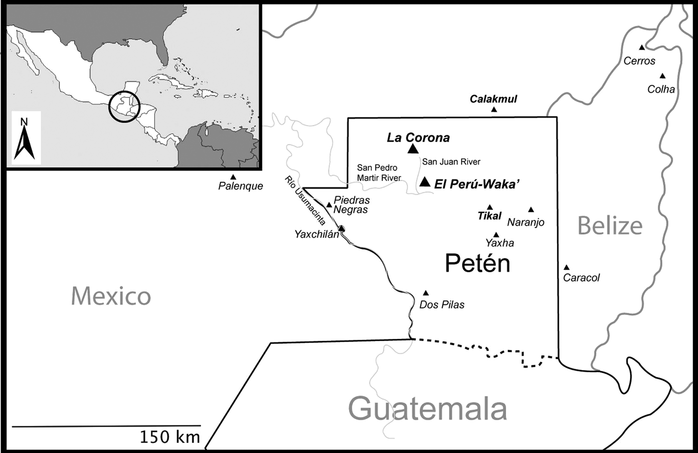
This article presents new data on chultunes from excavations at La Corona and El Perú-Waka’ (hereafter El Perú), two Classic period Maya sites in northwestern Petén, Guatemala (Figure 2) and smaller residential groups within their periphery. Although exceptions exist (Lentz Reference Lentz1991; Miksicek et al. Reference Miksicek, Wing, Scudder and Hammond1991), most chultunes excavated in the Maya lowlands have not been systematically floated. Therefore, this particular study also includes results from the analysis of flotation samples collected during all excavations. By presenting recent data on chultunes, the aim is to inspire archaeologists in the region to reconsider systematic excavations of chultunes and to include a range of methods for recovering as much data as possible. Before presenting the archaeological data recovered from El Perú and La Corona, I begin by reviewing previous excavations and hypotheses regarding the function of chultunes, as well as a brief section on experimental archaeology. Using the archaeological data presented here as well as from other investigations of chultunes, I argue that, although these features were likely used for storage, they may also have had ritual significance.
Map of the Department of Petén, Guatemala, with archaeological sites mentioned in text. Some sites are included in map only to situate the reader. Map by J.C. Melendez.

PREVIOUS RESEARCH ON CHULTUNES IN THE MAYA LOWLANDS
Excavations and Hypotheses
Although chultunes are most commonly located close to architectural constructions (Puleston Reference Puleston1971), they can also sometimes be found in isolation (Calderon and Hermes Reference Calderon, Hermes, Laporte, Arroyo and Mejía2005). Even so, the discovery of chultunes in a dense forest is arduous and most discoveries are accidental. Chultunes can have one chamber or multiple chambers that may be connected through stairs or grooves (Pinto and Acevedo Reference Pinto, Acevedo, Laporte, Escobedo and de Brady1993). The size and shapes of chultunes are extremely varied, both in term of their plan view, but also in profile (see Calderon and Hermes Reference Calderon, Hermes, Laporte, Arroyo and Mejía2005). Limestone lids covering the circular mouth (entrance) have been frequently reported (Hunter Reference Hunter1995; Puleston Reference Puleston1965) but wooden lids could have also been used; these may be lost due to poor preservation of organic materials (Pinto and Acevedo Reference Pinto, Acevedo, Laporte, Escobedo and de Brady1993).
Stephens (Reference Stephens1843) was the first to use the term chultun during his travels through Uxmal and Labná (Puleston Reference Puleston1965). However, Bishop Landa may have been the first to mention these features, although without using this specific term (Pinto and Acevedo Reference Pinto, Acevedo, Laporte, Escobedo and de Brady1993). Instead, Landa, probably writing in 1566, noted that the natives stored different varieties of maize in granaries and “fine underground places” (Tozzer Reference Tozzer1966:96, 195). In 1579, a little over a decade after Landa, Juan Gutiérrez Picón noted the presence of water-catching cisterns at the site of Tiquibalon (Ek’ Balam) in Yucatán, Mexico (Vargas de la Peña and Castillo Borges Reference De La Peña, Borges, De León, Rivera and Ruiz2006). According to Tozzer (Reference Tozzer1913), the term chultun comes from a Mayan language, meaning a cistern in stone, from tsul (clean) and tun (stone). Chultun is the singular word, a plural version would be chultunob (in Mayan), and in Spanish is converted to chultunes. This particular term is often applied to all subterranean pits without taking their function into account. Chultun is the term used in Yucatán for a water cistern but the word has been used to also describe human-made pits in bedrock, thus leading to confusion among scholars (Zapata Reference Zapata Peraza1989). Discussion over the terminology is beyond the scope of this paper—I use the term chultun (singular) and chultunes (plural) to discuss human-made pits dug into the limestone, found at sites across the Petén, as is convention among current scholars. While it is important to note that there is a general tendency for chultunes to differ between those in Yucatán (northern Maya lowlands) and those in the southern Maya lowlands of Petén, this difference is far from clear-cut.
Although the first excavations of a chultun are attributed to Thompson (Reference Thompson1897), Puleston (Reference Puleston1971) mentions that Maudslay (Reference Maudslay1883) likely excavated a two-chambered chultun at Tikal and presented the paper at the Royal Geographical Society in 1882, where he argued that these features were likely to be used for food storage. At Labná, Thompson (Reference Thompson1897) excavated 34 out of the 60 chultunes he investigated and wrote a detailed report that remains unparalleled. Thompson reported that they had been purposely lined, sometimes with stones and stucco, while others only had stucco lining on the walls; this suggested that chultunes were primarily used as water cisterns.
Tozzer (MacCurdy Reference MacCurdy1912) agreed that these features were water cisterns, due to their locations in areas where water availability was an issue, but he also remarked on the different types of chultunes found in northern Guatemala (i.e., department of Petén), namely the “cistern-like subterranean chamber” which are similar to those found in Yucatán, and a second “lateral-chambered” type, which he notes are more common in northern Guatemala (MacCurdy Reference MacCurdy1912:669). Other differences between the chultunes from Petén and Yucatán include the size and additional features; the latter are often more than two meters deep and are lined with stucco. Tozzer (Reference Tozzer1913) believed that no connection could be found between the features in Yucatán with those in Petén. He argued that the chultunes in Petén were not used for water storage, as the latter are located in a geographical area that did not want for water, are far from water sources, are built on higher ground with no drainage system, and lack any impermeable lining on the walls. Tozzer (Reference Tozzer1913) instead suggested that chultunes in Petén had multiple uses, such as for food storage, of maize in particular, as well as burial places.
Other scholars later proposed their own hypotheses on the function of chultunes. Ricketson (Reference Ricketson1925, Reference Ricketson and Ricketson1937) was in strong favor of chultunes being used as sweat baths. Smith (Reference Smith1950) and Schufeldt (Reference Schufeldt and Anderson1950) both argued for chultunes being used by the ancient Maya to reach the soft limestone marl located beneath the surface. Pollock (Reference Pollock1956) suggested they were used as drains or for refuse disposal and, along with Haviland (Reference Haviland1963), both propose they could have been used as latrines. Other hypotheses include those by Smith and Cameron (Reference Smith and Cameron1977), who suggested that Maya weavers were weaving inside chultunes during the dry season. Yet, besides a woven mat found inside Structure F at Uaxactún, no further supporting evidence has been found (Hunter Reference Hunter1995).
Cook (Reference Cook1935) early on argued that all chultunes (including those of Yucatán) were used for food storage, in particular for the nut of the ramon tree (Brosimum alicastrum). Others have supported this hypothesis (Blom Reference Blom1936; Bullard Reference Bullard1960; Ford Reference Ford1991; Freidel and Sabloff Reference Freidel and Sabloff1984; Puleston Reference Puleston1965). Puleston (Reference Puleston1965) argued based on his work at Tikal that the evidence suggested these features were used for food storage, although he acknowledged that none of the evidence was clear-cut. Puleston used several arguments to suggest that chultunes were used for food storage including the physical location of the chultunes, their association with residential areas at the site, and the way in which the ancient Maya constructed them. Namely, the presence of a lid, a raised sill located between the antechamber and the larger chamber, and the construction of the antechamber not directly under the entrance all would have served to protect the contents from any seeping rain. By the time Puleston published his 1971 article, 60 chultunes had been excavated and over 220 were known, and he decided that experimental archaeology was to be the best way to prove his hypothesis, which is detailed later.
Brady (Reference Brady2004), however, questioned why so much time and energy would have been spent on constructing chultunes for storage, especially considering that modern Maya populations use above ground storage spaces. Instead, he supports the idea that these underground constructions were artificial caves and argued they were used in household and public “earth rituals.” Dahlin and Litzinger (Reference Dahlin and Litzinger1986) also seemingly disagreed with the food storage hypothesis for a number of reasons, namely that there was no correlation between the number of chultunes and site and/or population size. They instead argue that they were used to ferment fruits to produce beers and wines, as chultunes offer the perfect environment consisting of high humidity levels, high temperatures, lack of light, and a closed environment with no ventilation (Dahlin and Litzinger Reference Dahlin and Litzinger1986:730). Thus, the long-term storage of alcoholic beverages was made possible by hermetically sealing and placing vessels underground, allowing for a cottage-level industry. Although the authors themselves mention that modern-day Lacandon Maya produce ritual alcoholic beverages (balche’), there seems to be no evidence to suggest that chultunes (or similarly-shaped features) are used for any step of the preparation. But they mention that sealing fermentation ollas followed by placing these underground has been observed in modern cases. The idea of fermentation aligns with ideas proposed by Miksicek et al. (Reference Miksicek, Wing, Scudder and Hammond1991:238) who argue that chultunes could have been used by ancient Maya to quicken the ripening process, citing an informant who mentioned a practice of ripening Annona sp. fruits by placing them underground for several days. Lentz (Reference Lentz1991) has argued that large quantities of coyol (Acrocomia sp.) fragments in a chultun at Copán lends support to the idea of fermentation but he is cautious and suggests that these could have fallen in, or have been deposited, after the chultun was no longer in use.
Finally, human remains and full interments within chultunes have been documented at numerous sites (Aylesworth Reference Aylesworth and Awe1993; Balcarcel and Stauber Reference Balcarcel, Stauber, Hansen, Suyuc and Balcarcel2004; Becker and Jones Reference Becker and Jones1999; Brown et al. Reference Brown, Quiroz, Plumer, Guderjan and Hanratty2014 Houk et al. Reference Houk, Robichaux and Valdez2010; Pellecer Reference Pellecer Alecio, Laporte, Arroyo and Mejía2006; Pinto and Acevedo Reference Pinto, Acevedo, Laporte, Escobedo and de Brady1993; Skidmore Reference Skidmore2011; Smith Reference Smith1950; Thompson Reference Thompson1897; Wauchope Reference Wauchope1934), including at El Perú (Menendez Reference Menéndez, Freidel and Melendez2009). While most scholars do not believe that chultunes were primarily burial places (e.g., Puleston Reference Puleston1971), some have proposed that such features were temporary burial locations until a final place was found (Hunter Reference Hunter1995). Interestingly, Chase and Chase (Reference Chase, Chase, Chase and Chase1994) suggested that chultunes were prototypes of later tombs built in the Late Classic.
Chultunes, more recently, are viewed as being multi-purpose, even when found at the same site, and scholars are more guided by the size, shape, and presence or absence of plaster on the walls when defining their uses (Calderon and Hermes Reference Calderon, Hermes, Laporte, Arroyo and Mejía2004; Garrison et al. Reference Garrison, Garrido, Axpuac, Smith, Beach, Luzzadder-Beach, Beltrán, López, Houston and Román2011; Miksicek et al. Reference Miksicek, Wing, Scudder and Hammond1991; Pinto and Acevedo Reference Pinto, Acevedo, Laporte, Escobedo and de Brady1993). Many scholars also tend to agree that materials contained in the chultunes are, in fact, secondary deposits and, thus, would have been re-used through time (Balcarcel and Stauber Reference Balcarcel, Stauber, Hansen, Suyuc and Balcarcel2004; Brown et al. Reference Brown, Quiroz, Plumer, Guderjan and Hanratty2014; Clark and Bryant Reference Clark and Bryant1997; Dahlin and Litzinger Reference Dahlin and Litzinger1986).
Experimental Archaeology
The earliest experimental work was carried out at Uaxactún, where Blom placed spades and machetes in chultunes at the end of a field season and found them rusted and not fit for use when the chultun was reopened almost two years later (Ricketson and Ricketson Reference Ricketson and Ricketson1937). Puleston (Reference Puleston1971) noted that this experimental work went against ideas proposed by Tozzer (Reference Tozzer1913:191), who argued that chultunes were rather dry.
At Uxmal, the re-plastering of a chultun and allowing rainwater to fill it in, allowed for an archaeological crew to work during a whole field season (Puleston Reference Puleston1965). Puleston (Reference Puleston1971) subsequently carried out some experiments in which water was poured into a unlined chultun. But not even eight hours later, it was empty. He further experimented by building a new chultun and, using various types of flint tools, he dug one in approximately 30 hours, which he considered a rather easy process. This supports Tozzer's (Reference Tozzer1913) argument that it would not be difficult to build a chultun, due to the soft limestone typical of the Petén landscape. However, the geology of Yucatán is especially good for the construction of chultunes. The reason is that the local bedrock typically contains a case-hardened layer, under which there is usually a softer layer of marl, locally known as sascab (Dunning Reference Dunning1992:20). Chultun construction would have likely been much harder in areas where this type of geology was absent. Shook and Hatch (1999) propose that the construction of chultunes was carried out using a wooden instrument but it is unclear how long this would take as they did not experiment. Puleston also experimented with storage of various plant foods and placed within this new chultun a variety of plant foods including maize (Zea mays), beans (Phaseolus sp.), squash (Cucurbita sp.), and several species of tubers. Following regular checks, it was found that the plant foods all decomposed at different rates and, therefore, the chultun was not suitable for storage, as although the foods were protected from vermin they were still prone to fungi in a humid environment. Not even parching the maize yielded better results. Reina and Hill (Reference Reina and Hill1980) note that Colonial-period sources mention that maize was parched for almost two weeks prior to storing it underground. It is unclear how long the maize was parched in Puleston's (Reference Puleston1971) experiments prior to being placed in the chultun, and whether this shorter time of parching contributed to lack of preservation. A second round of tests were carried out and ramon nuts were the only food to survive the chultun test; after 13 months underground these were still edible and in good condition (Puleston Reference Puleston1971). This led Puleston to argue that, if indeed chultunes were used for ramon storage, this food stopped being important to the Postclassic period Maya as, following the collapse, these features were no longer constructed. More recent excavations by Calderon and Hermes (Reference Calderon, Hermes, Laporte, Arroyo and Mejía2005), however, demonstrate that chultunes were clearly also used by the Postclassic Maya. While scholars such as Cook (Reference Cook1935) and Puleston (Reference Puleston1965) believe in the importance of ramon to the Maya diet, scholars have remained skeptical mainly due to lack of botanical evidence (Lentz Reference Lentz and White1999; Miksicek et al. Reference Miksicek, Elsesser, Wuebber, Bruhns and Hammond1981; Reina and Hill Reference Reina and Hill1980; Turner and Miksicek Reference Turner and Miksicek1984).
A similar experiment was carried out, using a previously excavated chultun at Cuello (Miksicek et al. Reference Miksicek, Wing, Scudder and Hammond1991). Plants similar to those placed by Puleston (Reference Puleston1971) were included, as well as unhusked maize, previously smoked for one, five, and 10 days. The results confirmed Puleston's findings, with ramon being the only plant able to survive and remain edible after one year of storage inside a chultun. Root crops didn't last as long as the ramon, yet they lasted longer than maize and beans. The authors acknowledged that they failed to fill the entire chultun with plant foods, and this may be the key to long-term storage of all types of foods. Miksicek et al. (Reference Miksicek, Wing, Scudder and Hammond1991) cite a study by Reynolds (Reference Reynolds1979), whereby foods in replicas of Iron Age pits in Britain were successfully stored. It is suggested that constant carbon dioxide levels may play an important role in the preservation of plant foods being stored as well as sealing the pit. Miksicek et al. (Reference Miksicek, Wing, Scudder and Hammond1991) note that perhaps lining the chultun with vegetable mats may improve the storage,and suggest that may be the reason for the sawgrass seeds found in flotation samples. Moreover, the authors note that making a fire inside the chultun could seal it, and increase levels of carbon dioxide. Evidence of smudging on walls is reported from Colha (Miksicek et al. Reference Miksicek, Wing, Scudder and Hammond1991:80).
Although this review is not an exhaustible list of chultunes discovered or excavated in the Maya area, it provides an overview of the range of hypotheses proposed for their existence. While experimental archaeology has provided interesting data, none of the studies have definitely resolved issues related to the use of chultunes. Thus, it is clear that further archaeological investigations of such features are necessary (Aylesworth Reference Aylesworth and Awe1993) if we are to gain a better understanding of the features themselves and recover materials that in turn can address a range of other research topics.
Chultunes at La Corona and El Perú-Waka’
La Corona and El Perú are located with the Laguna del Tigre National Park, a protected reserve that is part of the larger Maya Biosphere developed by the Guatemalan government. The sites are about 40 kilometers apart, both located along routes that are believed to have been important for the movement of trade goods that connected diverse resource-rich areas (Canuto and Barrientos Reference Canuto, Barrientos, Laporte, Arroyo and Mejía2009; Freidel and Escobedo Reference Freidel, Escobedo, Escobedo and Freidel2006). The developmental histories indicate that the rulers of both sites had complex and shifting alliances with the super powers of the Classic period: Tikal and Calakmul (Barrientos and Canuto Reference Barrientos, Canuto, Barrientos, Canuto and Ponce2014; Freidel et al. Reference Freidel, Escobedo, Guenter, Sabloff and Fash2007).
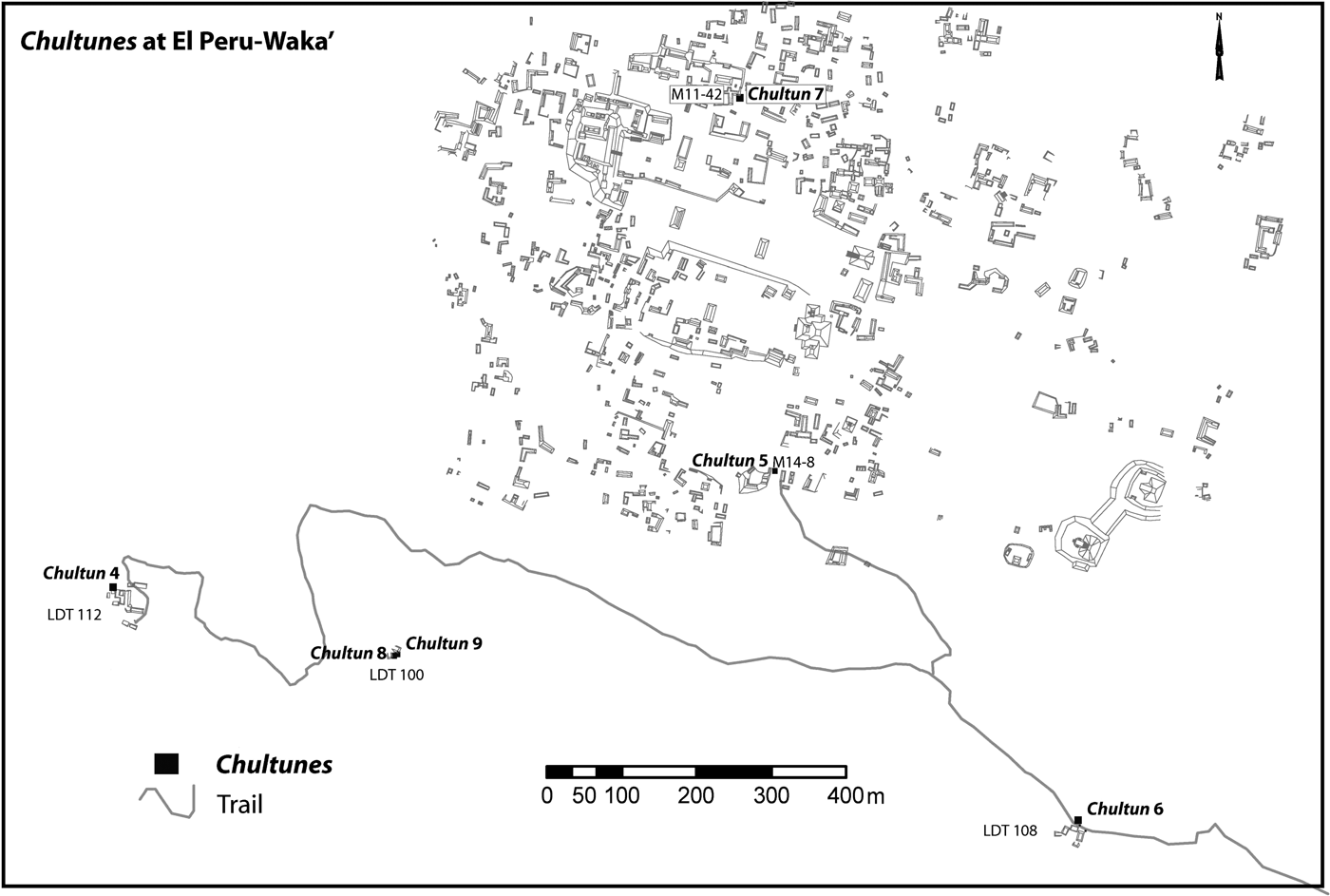
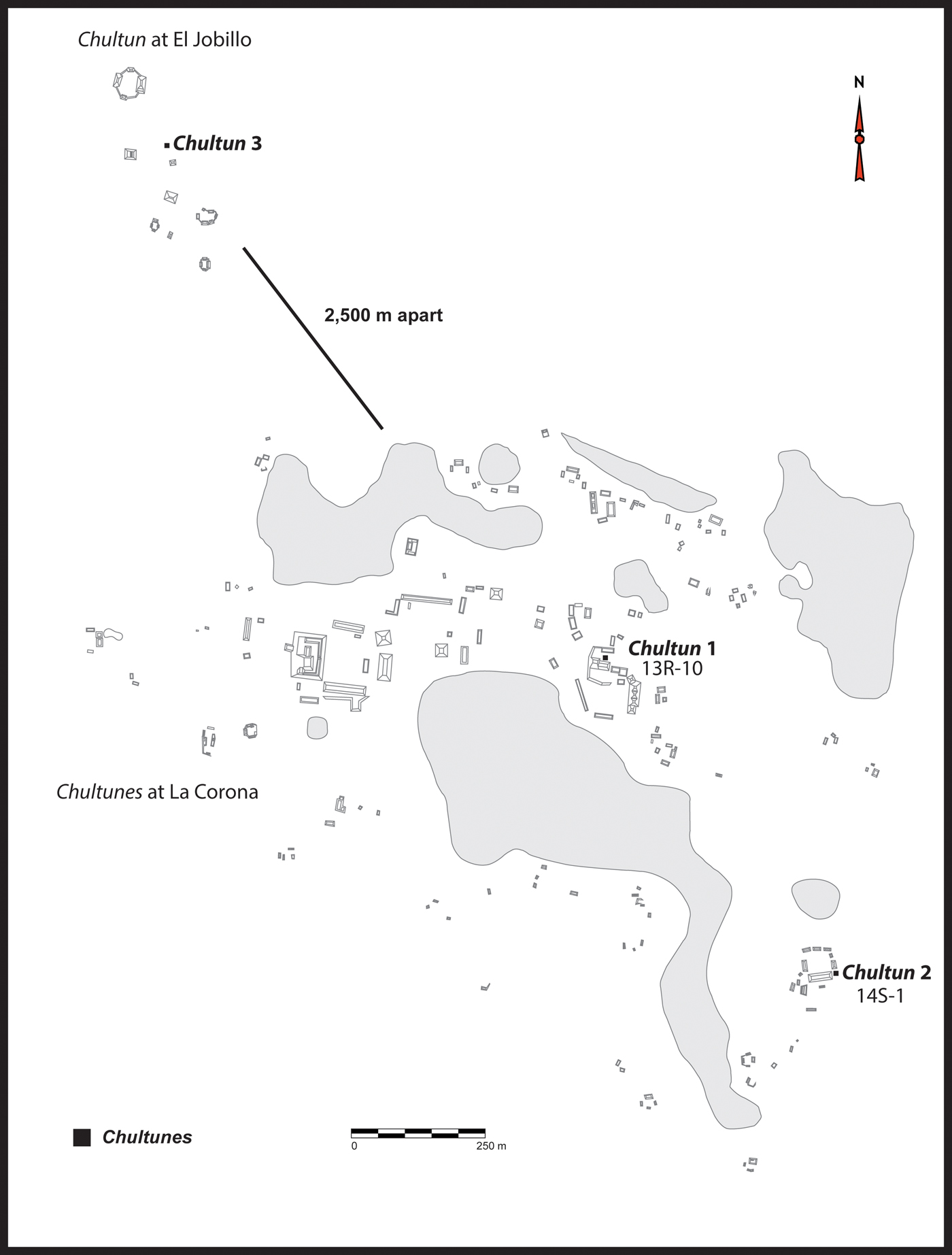
There is evidence of occupation at El Perú and La Corona from as early as the Late Preclassic, but the sites flourished in the Classic period. El Perú consists of four main plazas (Figure 3) and more than 750 structures in the site's core (Tsetsmeli Reference Tsetsmeli and Acuña2011), with an additional 127 residential groups in the periphery (Marken Reference Marken2011). Smaller sites within the periphery have also been mapped and a few have been excavated (Quiroa Flores and Perez Robles Reference Quiroa Flores, Griselda Perez, Escobedo and Freidel2005; Menendez Reference Menéndez, Freidel and Melendez2009). La Corona is a smaller site (Figure 4) where the core and surrounding household groups are encircled by several lagoons (civales). Although the site is considered a secondary center, it does not fit politically with typical models of secondary centers, and may have been a strategic frontier site governed by Calakmul's royal family (Barrientos and Canuto Reference Barrientos, Canuto, Barrientos, Canuto and Ponce2014). The core of the site is composed of four monumental groups with several other residential groups located within it. The majority of La Corona was constructed in the Late Classic period. Construction during the Early Classic has been also identified in part of the structures located southeast of the Main Group plaza.
Map of El Perú showing locations of chultunes mentioned in the text. Map by Evangelia Tsesmeli.

General map of La Corona. Modified from maps by the Proyecto Regional Arqueologico La Corona.

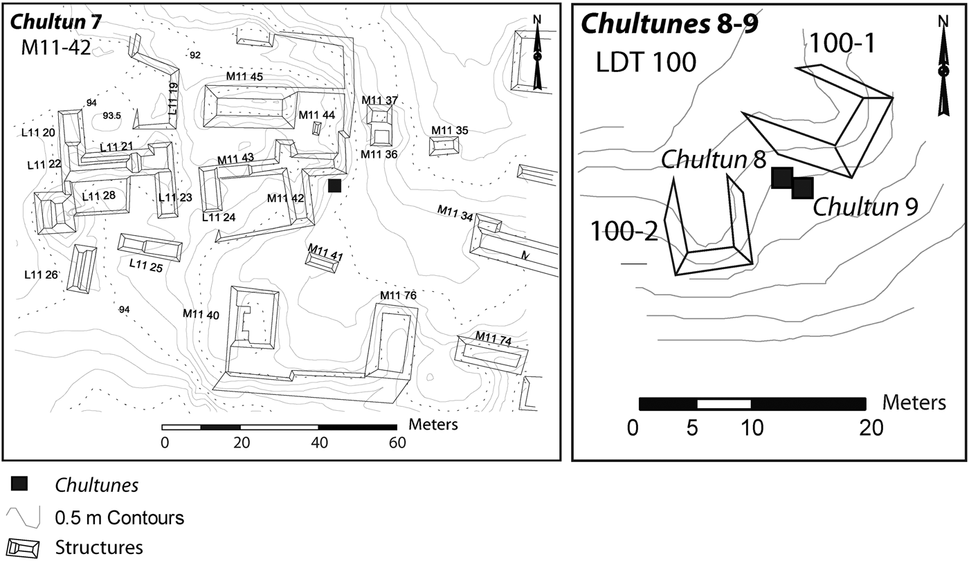
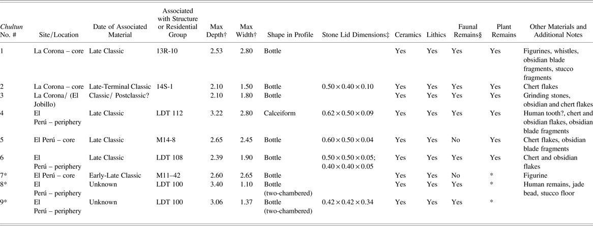
Archaeological investigations at both sites have revealed the existence of chultunes. With one exception, all the chultunes were deliberately searched for. Finding these features on the landscape, however, was made difficult by the thick forest cover. In total, the author excavated five chultunes (Table 1). At El Perú, three chultunes had previously been excavated; soil samples for subsequent flotation were not collected, however. These three chultunes are included for comparative purposes and their exact locations shown in Figure 5. Other chultunes have been identified at El Perú (D. Marken, personal communication 2012; Quiroa Flores (Reference Quiroa Flores, Escobedo and Freidel2007) but remain unexplored. Fernández (Reference Fernández, Barrientos Q., Canuto and Acuña2011) discovered the first chultun at La Corona, while the author excavated the remaining two. A second chultun at El Jobillo (a smaller site about 2.5 kilometers northwest of La Corona) was identified by the author but remains unexplored.
Location of previously excavated chultunes at El Perú. Map by Evangelia Tsesmeli.

Summary of Dimensions, Shape, and Associated Materials Recovered from Chultunes at La Corona and El Perú

Notes. All measurements are given in meters. Number of artifacts recovered are provided in the text. Data compiled from Cagnato (Reference Cagnato, Barrientos Q., Canuto and Ponce2012, Reference Cagnato, Barrientos Q., Canuto and Ponce2013a, Reference Cagnato and Calderon2013b).
* Previously excavated, and therefore no soil samples collected/analyzed. Chultun 7 excavated by Ramirez (Reference Ramirez, Escobedo and Freidel2006), and Chultunes 8 and 9 by Menendez (Reference Menéndez, Freidel and Melendez2009).
† For multiple-chambered chultunes, only dimensions of main chamber are given.
‡ Stone lid measurements indicate its length × width × thickness.
§ Faunal remains includes shell fragments.
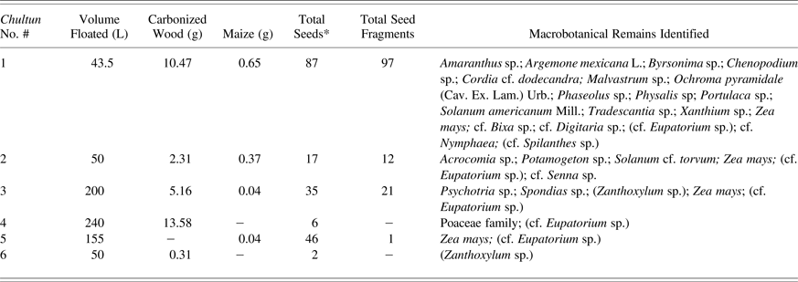
During the excavation of the chultunes, with the exception of those collected for flotation, all soils were sieved in order to recover small artifacts. Unless there was a visible change in stratigraphy, excavation layers were usually 20 cm thick. The author collected soil samples, and whenever possible, standardized volumes of soil (20 L) were collected from each excavated layer following a composite sampling strategy (Pearsall Reference Pearsall2000:69). Fernández (Reference Fernández, Barrientos Q., Canuto and Acuña2011) collected smaller samples from Chultun 1 and only from layers 6 to 12. Soil samples of topsoil or humus layers were not collected for flotation from chultunes excavated by the author (i.e., 2–6) as these were found unsealed. The author carried out all the flotation and subsequent analysis. Flotation was carried out using a mixture of bucket flotation and, when there was access to sufficient amount of water, a modified version of a SMAP machine (Fritz Reference Fritz, Maschner and Chippindale2005:780–784; Pearsall Reference Pearsall2000:29–33; Watson Reference Watson1976:79–80) was used. Heavy fractions were collected using a 1.6 mm mesh and the light fractions were collected using 0.355 mm mesh. Plant remains were identified using the standard methods used at the Paleoethnobotany Laboratory at Washington University in St. Louis (Fritz Reference Fritz2016). Only carbonized remains are considered in the final analysis, as it is unlikely that un-carbonized plant remains survive the dry-wet cycles of the Neotropical region (Lentz Reference Lentz1991). Heavy fractions were scanned for any materials, while the light fractions were examined entirely. All plant remains greater than 2.0 mm were counted, weighted, and recorded; below 2.0 mm only seeds and other plant remains were separated and recorded. Macrobotanical results are presented in Table 2.
Summary of Flotation and Starch-grain Analysis from Chultunes at La Corona and El Perú

Notes. Species in brackets may be intrusive. L = liters; g = grams
* Total does not include maize kernels or kernel fragments
Wood charcoal samples were sent to Woods Hole Oceanographic Institute for radiocarbon dating. All samples were calibrated at 2σ with the program OxCal 4.2, using the IntCal 13 curve (Bronk Ramsey Reference Ramsey2009; Reimer et al. Reference Reimer, Bard, Bayliss, Beck, Blackwell, Ramsey, Grootes, Guilderson, Haflidason, Hajdas, Hatté, Heaton, Hoffmann, Hogg, Hughen, Kaiser, Kromer, Manning, Niu, Reimer, Richards, Scott, Southon, Staff, Turney and van der Plicht2013) and presented in Table 3.
Radiocarbon Dates Obtained from Wood Charcoal Collected from Chultunes at La Corona

* OS is the code for Woods Hole Oceanographic Institute
** cal a.d., 95% probability
EXCAVATION RESULTS
La Corona
Chultun 1
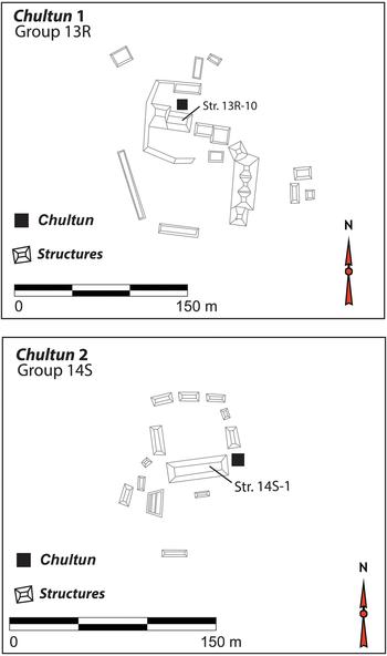
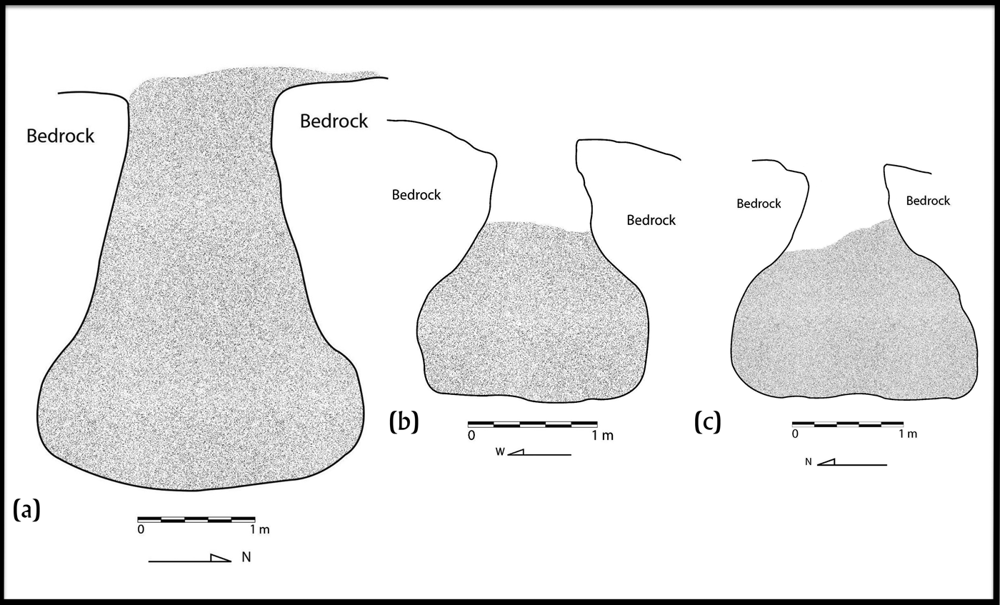
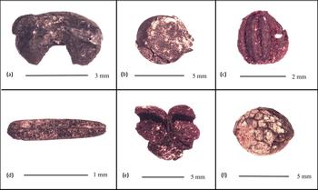
Fernández (Reference Fernández, Barrientos Q., Canuto and Acuña2011) discovered and excavated the first chultun at La Corona in 2010. This chultun is located in the ceremonial center of the main site, adjacent to Structure 13R-10 (Figure 6), which was constructed in the Late Classic period and was an important place for feasting and rituals (Ponce Reference Ponce2013). The chultun was found sealed by the construction of a platform and measured 2.53 m deep by 2.80 m wide, and has a bottle-shaped profile that is visible in bisected view (Figure 7a). The stratigraphy of the chultun is not known; based on the soils received for flotation, however, the chultun contained various lenses of ash and reddish soil. Therefore the soil matrix was not uniform. Based on the good preservation of the materials inside the chultun, it would appear that the material was deposited after one large feasting event (Fridberg Reference Fridberg2015; Fridberg and Cagnato Reference Fridberg and Cagnato2013; Parris Reference Parris2014). The chultun contained large quantities of ceramics (>5500 sherds), lithics, figurines, ocarinas, and a wide variety of faunal species (Baron Reference Baron2013; Fernández Reference Fernández, Barrientos Q., Canuto and Acuña2011; Fridberg and Cagnato Reference Fridberg and Cagnato2013). The flotation samples contained carbonized wood and over 500 plant remains, including whole maize kernels (Figure 8a), seeds of herbaceous plants, and seeds of fruit trees (see Table 2). Project ceramicist Carrie Parris (personal communication 2014) dates the ceramic material to the Late Classic period after a.d. 760 due to the presence of Chicxulub Incised Fine Gray ceramics. Radiocarbon analysis of two charcoal pieces collected from two separate levels of the chultun support this interpretation (Table 3).
Locations of Chultunes 1 and 2. Modified from maps by the Proyecto Regional Arqueologico La Corona.

Profile drawings of chultunes from La Corona: (a) Chultun 1, (b) Chultun 2, and (c) Chultun 3. Shaded area indicates level of soil present when the chultun was discovered. Drawing by J. C. Melendez.

Select seeds recovered inside the chultunes from La Corona and El Perú: (a) maize kernel; (b) fabaceae seed (cf. Senna sp.); (c) Psychotria sp.; (d) Asteraceae achene (cf. Eupatorium sp.); (e) maize glumes; and (f) Zanthoxylum sp. seed. Photographs by the author.

Chultun 2
The chultun is located in a group of residential structures, located 1.05 km south of the main core of La Corona, and consists of 12 mounds that form two separate plazas (Pontaza and Gonzalez Reference Pontaza, González, Barrientos Q., Canuto and Ponce2013). The chultun was found 5.50 m to the east of the largest structure of this group (Structure 1), which also formed the southeastern corner of the larger plaza (Figure 6). From the surface, the chamber of the chultun measured at its widest 1.50 × 1.00 m. The chultun reached a total depth of 2.10 m (Figure 7b). Halfway to the bottom of the pit, a stone lid was found in one piece. The lid must have fallen in at some point. Thus, the fill of the chultun is likely to contain both ancient and more recent materials. Stratigraphically, below a thick (ca. 40 cm) layer of humus, the entire chultun consisted of the same sandy and light gray soil. Stones and larger rocks were also recovered, especially in the third layer. A total of 128 ceramic sherds were found dating to the Late to Terminal Classic period (Carrie Parrison personal communication 2012); supporting the radiocarbon dates (Table 3). Plant remains include small amounts of carbonized wood, maize kernel fragments, and one Fabaceae seed (compare Senna sp., Figure 8b), among other remains (Table 2). Other materials were recovered, namely 21 lithic pieces and animal bones. Similarly to the chultun previously described, this one is also simple, bottle-shaped in profile, and circular in plan view. It was not possible to measure the he original dimensions of the mouth, as sections of the entrance had collapsed inwards, but the mouth likely measured the same width and length as the stone lid (see Table 1).
Chultun 3
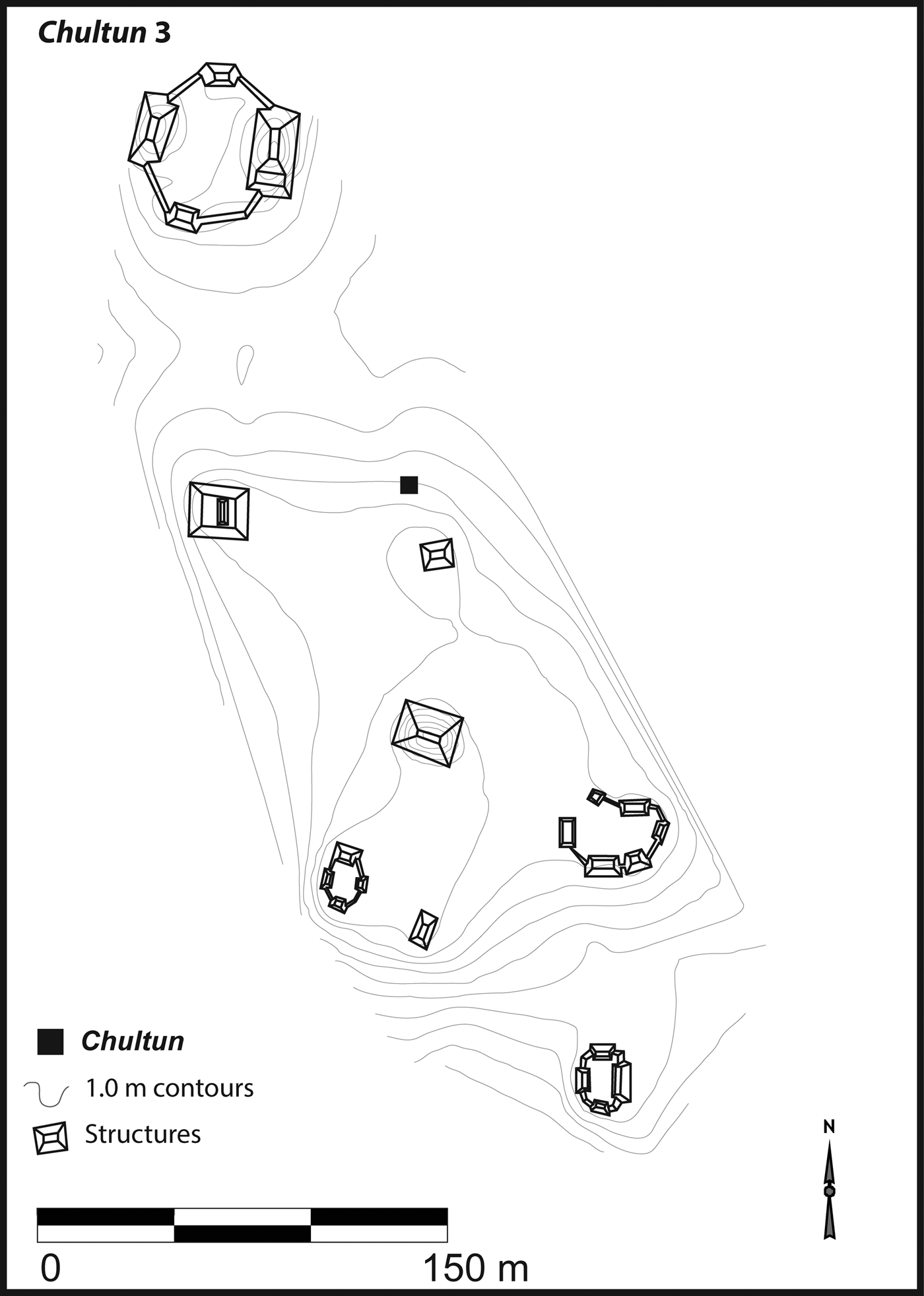
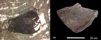
This chultun was discovered at El Jobillo, a smaller site about 2.5 km northwest of La Corona. The site consists of six individual residential groups that have yet to be formally investigated. The chultun was not closely associated with any particular structure, with the nearest structure located about 30 meters southeast (Figure 9). Thus, it seems to be centrally located. As mentioned earlier, at least one more chultun was identified at this smaller site. The excavated chultun was discovered without a lid and the chamber was about three-quarters full of soil. This chultun is also bottle-shaped (Figure 7c) and consists of one chamber, reaching a maximum depth of 2.10 m and a maximum of 1.80 m in width. The mouth measured 0.60 × 0.90 m; it is possible, however, that this was not its original size, as the entrance seems to have eroded, and the absence of a stone lid further limited the possibility of establishing the original dimensions. The first layer consisted of a 22-cm thick layer of humus and contained carbonized plant material, including seeds. The seeds were easily identifiable, as many of these were largely intact. These seeds belong to plants that currently grow near and around the chultun and, considering that the chultun was found unsealed, there is a strong possibility that these plant remains within the first layer are in fact modern and intrusive. Subsequent layers of soil were darker and more compact. In layer 5, the soil around the metate fragments (see below) was more clayey. In lower layers, the soil in the center of the chultun was more compact than the soil on the edges. The entirety of layer 9 was composed of sand and small pebbles and, by the final layer (10), the sediment was powdery and white. The contents of this chultun included 357 ceramics, eight obsidian and chert pieces, and four metate (mortar stone) fragments; one fragment is shown in situ and fully excavated (Figures 10a–10b). Results of the microbotanical analysis carried out on the metate surfaces are forthcoming; preliminary analysis indicates that various plant species, including root crops, were processed. Macrobotanical remains included carbonized wood fragments, along with maize and one Psychotria sp. (Figure 8c) seed. It should be noted that many of the plant remains were only partially carbonized (e.g., Spondias sp.). The radiocarbon dates obtained from the wood charcoal clearly postdate the Classic period occupation (Table 3). The ceramics, however, were extremely eroded and span the Early to Terminal Classic (Carrie Parris, personal communication 2015).
Location of Chultun 3 at El Jobillo. Modified from maps by the Proyecto Regional Arquelogico La Corona.

Metate fragment recovered inside Chultun 3 at El Jobillo. (a) In situ fragment; (b) metate fragment removed from chultun. Photographs by the author.

El Perú-Waka’
Chultun 4
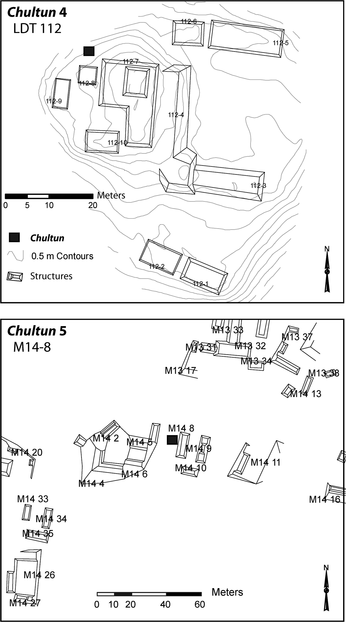
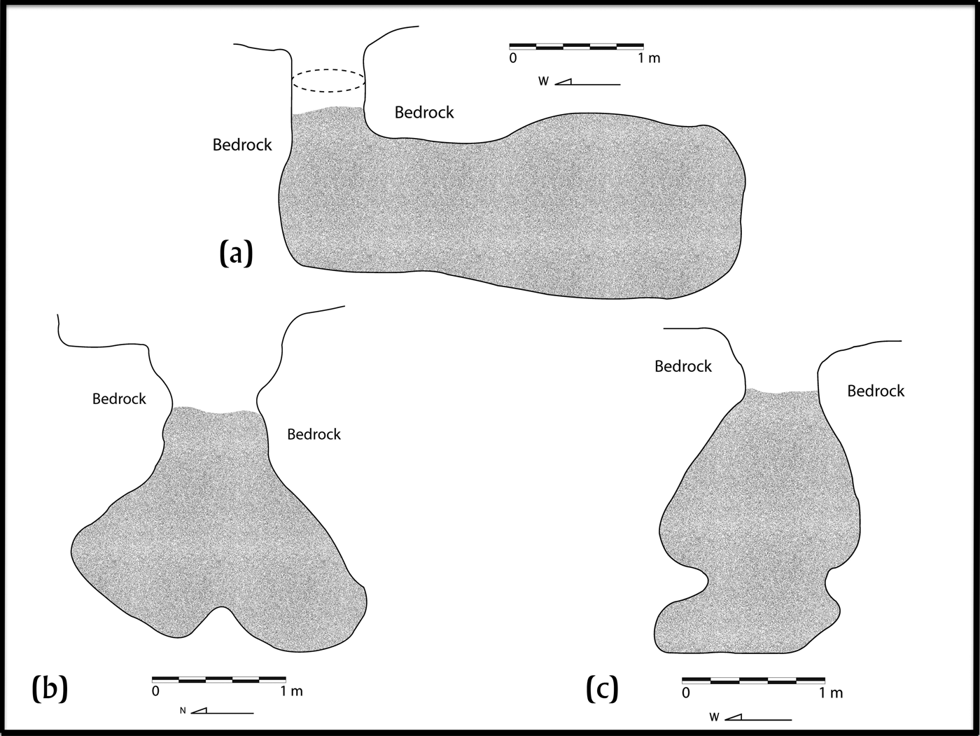
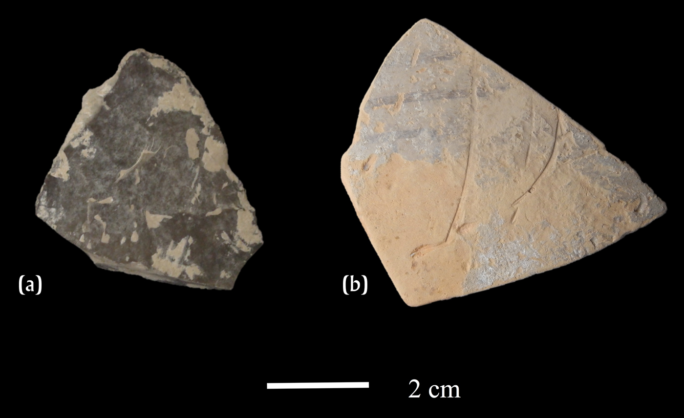
This chultun was associated with Group LDT112, a medium-sized settlement composed of 10 structures arranged to form two plazas, 0.88 km to the southwest of the main core (Figure 11a). The chultun was located approximately 5 meters north of Structure 8, which is one of the structures that forms part of the smaller plaza group. The chultun measured 2.80 m in width by 3.22 m in length and was composed of one chamber that was calceiform in profile (Figure 12a). The mouth of the chultun was found with a stone lid, albeit slightly displaced by the root of a large tree. The mouth measured 0.65 × 0.40 m wide, and had a neck that measured 1.50 m deep. Below the humus, layers 3 and 4 were composed of more compact soil, with sandy and silty soil present until layer 7, whereby pebbles and rocks became more common. Subsequent layers (8–10) consisted of more sandy soil. The soil became more compact once again in layers 11–13, but looser in layer 14. A thin clayey layer was noticed in layers 15 and 16. Pieces of carbonized wood visible to the naked eye were observed in layers 9, 14, and 17. In total, 215 ceramic sherds, many of which were eroded, were recovered including some belonging to Tinaja Red and Infierno Black ceramics. These ceramics place the materials in the Late Classic period; one fragment of a Fine Orange vessel (Figure 13a), however, indicates Terminal Classic material (J. C. Melendez, personal communication 2014). Other materials recovered include 12 animal bones such as a peccary tooth and a fish scale, one shell fragment, and 21 lithic fragments, including one chert point (Figure 13b; Menéndez Bolaños Reference Menéndez Bolaños, Calderon and Freidel2013). Besides large pieces of charcoal intermixed in the soil, the most common plant remain belongs to a species of Asteraceae, possibly Eupatorium sp. (Figure 8d).
Location of Chultunes 4 and 5. Map by Evangelia Tsesmeli.

Profile drawings of chultunes from El Perú: (a) Chultun 4, (b) Chultun 5, and (c) Chultun 6. Shaded area indicates level of soil present when the chultun was discovered. Dotted lines represent location of in situ limestone lid. Drawings by J. C. Melendez.

Artifacts recovered from Chultun 4 at El Perú: (a) chert point (photograph by Elsa D. Menendez); (b) fine Orange ceramic sherd (photograph by Griselda Perez Robles).

Chultun 5
The second chultun from El Perú is located approximately 5 m to the west of Structure M14-8 and 200 m south of Plaza 2 (Figure 11b). The chultun was found without a lid, and with one of the large roots of a nearby ramon tree finding anchor inside it. This chultun had one chamber, measured a maximum of 2.65 m, and 2.45 m wide, and was bottle-shaped in profile and circular in plan view (Figure 12b). The mouth of the chultun measured 90 × 90 cm. Two meters into the chultun, an intact stone lid was found. The first three layers consisted mainly of topsoil and silty brown soil that may have been originally inside the chultun. In layer 4 this soil changed to a finer, sandier yellow soil and this matrix continued until the bottom of the chultun was reached in layer 9. Although no charcoal was recovered during excavation or in the flotation samples, maize in the form of glumes attached to the cob (Figure 8e) and over 40 Asteraceae seeds were recovered. Other materials recovered include 545 ceramic sherds, 27 lithic fragments, including obsidian and chert blade fragments, and 16 mother-of-pearl fragments. Although some diagnostic Early Classic sherds with a basal flange and a cylinder with carved hieroglyphs were noted (Figure 14a), the ceramics were generally identified as Late Classic types. These include Encanto Striated, Tinaja Red, Infierno Black, eroded polychrome sherds, sherds belonging to a Chaquiste Impressed bowl with fingernail impressing, and a Pantano Impressed jar (Figures 14b–14c; J. C. Melendez, personal communication 2014).
Select ceramic sherds recovered inside chultun 5 at El Perú: (a) sherds with hieroglyphs belonging to a cylinder; (b) Chaquiste Impressed bowl sherd with nail impressions; (c) Pantano Impressed jar sherd. Photographs by Juan Carlos Melendez.

Chultun 6
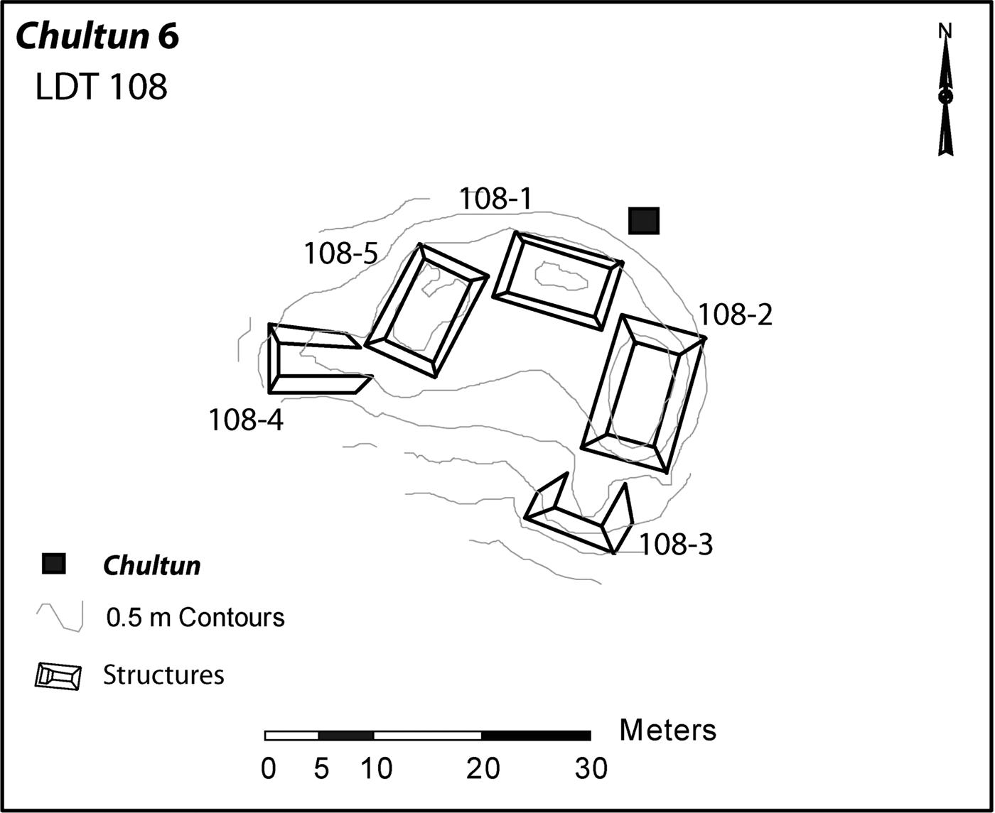
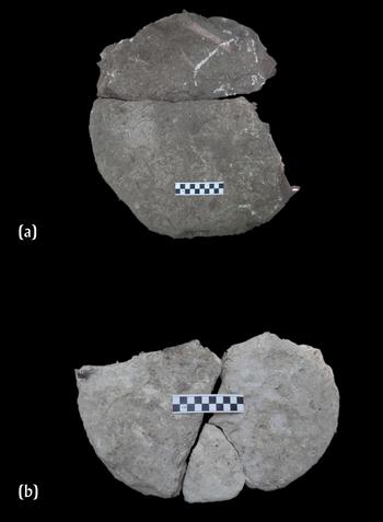
The third chultun from this site was located in association with Group LDT 108, circa 0.70 kilometers south from the main site (Marken Reference Marken, Freidel and Melendez2009). The group consists of five structures, which together form a small hamlet or residential unit. The chultun was about 6 meters northwest of Structure 2 (Figure 15). This one-chambered chultun consisted of two levels (Figure 12c), with the deepest level reaching 2.39 m and the maximum width reaching 1.90 m. This feature was found without a lid, with the mouth measuring 0.43 × 0.54 m wide. In the second layer, at 1.08 m below the surface, a fragment of the lid was located, and a second fragment was found in levels below; these fit together nicely (Figure 16a). Almost at the bottom of the chultun (layer 6), a second stone lid was recovered (broken in three fragments; Figure 16b), and appears to have been smaller and more oval in shape than the first one. In terms of the stratigraphy, below the usual topsoil, a light brown silty soil was found in the second layer. However, in the third layer, the soil changed again to a sandy and pebble-like texture. In the fifth layer, at around 1.80 m below the surface, it became obvious that the chultun was deeper only one side, and the soil changed to a powdery texture, almost white in color; this continued until the bottom of the chultun was reached in layer 7. Carbonized wood fragments were found in small quantities and other plant remains include uncarbonized Zanthoxylum sp. seeds (Figure 8f). Other materials recovered include 13 lithic pieces and 160 ceramic sherds, which include Late Classic types such as Tinaja Red, Encanto Striated, and Infierno Black (J. C. Melendez, personal communication 2014).
Location of Chultun 6. Map by Evangelia Tsesmeli.

Fragmented lids recovered inside Chultun 6 at El Perú: (a) Lid fragments found in upper layers of the chultun and (b) lid fragments found in layer 6. Scale bars in centimeters. Photographs by the author.

DISCUSSION
The excavation of three chultunes from La Corona and a total of six at El Perú, including the three previously excavated at this site, demonstrate that each chultun is, in fact, unique. Not only do chultunes vary in size and shape, their contents also differ and, in turn, reveal different types of information regarding the ancient Maya.
Among the many issues related to chultunes in the Maya region, the timing of their actual construction remains relatively uncertain. Although the chultunes presented here were carefully and completely excavated, the exact timing of when the chultunes were re-used remains uncertain. With the exception of Chultun 1, stratigraphy within these features suggests that separate episodes of deposition occurred. The mixing, however, of cultural materials from different time periods makes it more difficult to pinpoint the more discrete episodes of chultun reuse. Thus, as previous archaeologists have already noted, the dates of construction remain unknown, and the material goods recovered inside are used to indicate a general range of dates for the secondary use of the chultun. The artifacts and radiocarbon dates indicate that most materials were deposited in the Late Classic period. Radiocarbon dates from Chultun 3 are the exception. Occupation during the Postclassic is not known from around La Corona, except for visitors performing rituals and leaving behind censers on several structures of the abandoned site (Baron Reference Baron2013). This late radiocarbon date may indicate that the chultun was contaminated with more recent charcoal as a result of a natural forest fire or could be the result of human activity at the site. Further research is needed to ascertain this, in particular through excavations at El Jobillo to determine whether Postclassic material can be identified elsewhere at this site.
If we consider the nine chultunes excavated thus far at both sites we can say that the Maya in this area had a general tendency to construct bottle-shaped chultunes. The one exception was Chultun 4, which was elongated or calceiform, and more similar to chultunes reported at the site of Yaxha (Calderon and Hermes Reference Calderon, Hermes, Laporte, Arroyo and Mejía2005). The chultunes excavated by the author were all single-chambered, except for Chultun 6 that, although it had two levels, technically remained single-chambered. None of those excavated by the author were double-chambered; however, previous excavations indicate that these forms existed at El Perú (Menéndez Reference Menéndez, Freidel and Melendez2009). Multiple-chambered chultunes are also reported from various sites in Petén (Calderon and Hermes Reference Calderon, Hermes, Laporte, Arroyo and Mejía2005; Pellecer Reference Pellecer Alecio, Laporte, Arroyo and Mejía2006; Pinto and Acevedo Reference Pinto, Acevedo, Laporte, Escobedo and de Brady1993). Until new data is gathered, chultunes at El Perú appear to be more variable in shape than those of La Corona.
In terms of size, the average maximum depths at La Corona and El Perú were 2.24 m and 2.87 m, respectively. In terms of the maximum widths, the averages were 2.03 m for La Corona and 2.04 m for El Perú. Although very similar in width, the chultunes at El Perú are notably deeper than those of La Corona. When these are compared to other single-chambered features in the southern Maya lowlands for which we have measurements, for example from Cuello (Hammond et al. Reference Hammond, Gerhardt, Donaghey and Hammond1991), Caracol (Hunter Reference Hunter1995), and the Mirador Basin (Balcarcel and Stauber Reference Balcarcel, Stauber, Hansen, Suyuc and Balcarcel2004), chultunes from El Perú and La Corona tend to be less wide but are significantly deeper. However, to establish whether there is a site-specific style of chultunes, a larger sample of these features will be necessary.
Stone lids were common, although for the most part were not found in situ, except for Chultunes 4 and 9. However, most chultunes had either whole or fragmented lids recovered inside, with only one having evidence of two lids. All of the limestone lids discovered were round or ovate in shape and roughly the same size, with the longest lid measuring 0.62 m and the widest measuring 0.50 m. These measurements fall within the range of those reported elsewhere (see Becker and Jones Reference Becker and Jones1999; Hunter Reference Hunter1995; Pinto and Acevedo Reference Pinto, Acevedo, Laporte, Escobedo and de Brady1993). With the exception of the lid for Chultun 9, the lids tend to be no thicker than 10 centimeters.
One of the major questions that archaeologists have regarding chultunes is their function. Based on the evidence of chultunes from this part of Petén, I would argue that, unlike chultunes in Yucatán, these were not used for water catchment, as none of the chultunes excavated by the author had evidence of stucco on the inside, while all have porous and irregular walls. One exception is Chultun 8, where Menéndez (Reference Menéndez, Freidel and Melendez2009) reported finding a stucco floor as well as stucco fragments in the center of the feature. If these fragments are the remains of plastered walls, it is possible that this particular chultun was used to catch water.
While chultunes could have been viewed as artificial caves and, therefore, as liminal spaces between the real world and the underworld (Vogt and Stuart Reference Vogt, Stuart, Prufer and Brady2005), I would argue that, based on their ubiquity on the landscape and proximity to residential areas (Ford Reference Ford1991; Puleston Reference Puleston1965), these were not solely ritual spaces; I return to this later. Regardless of the time it would take to construct chultunes, the ability to store food for extended periods of time, especially in wet, humid areas, seems crucial. Moreover, as already noted by Puleston (Reference Puleston1971) the use of heavy lids would suggest that chultunes contained valuable goods. Thus, I believe that these chultunes could have originally served a utilitarian purpose, probably as food storage facilities, an idea already put forward by previous scholars (e.g., Cook Reference Cook1935; Puleston Reference Puleston1965). The use of underground storage pits is not unique to the Maya region, as similar features are known from other regions in the world (e.g., Gronenborn Reference Gronenborn1997; Reynolds Reference Reynolds1979; Wilson Reference Wilson1987). It is interesting to note that Landa mentioned that the Maya used both underground storage spaces and granaries during the Colonial period (Tozzer Reference Tozzer1966), although it remains unclear what was actually stored in the former. More contemporary studies, however, have noted that the Maya never used pits to store food (Hayden and Cannon Reference Hayden and Cannon1983; Puleston Reference Puleston1965). If indeed chultunes were originally used to store food, this change in practice is interesting, and archaeologists should consider further investigations into when and why chultunes stopped being used by the ancient Maya.
If chultunes were, in fact, used as storage spaces, the main problem would be the high levels of humidity. Unlike Tozzer (Reference Tozzer1913), who argued that chultunes were relatively dry, I can assert to the high levels of humidity inside the chultunes; it felt like one was in a sauna after only a couple of minutes (see also Clark and Bryant Reference Clark and Bryant1997:130; Puleston Reference Puleston1971). Of course, high levels of humidity would be useful if fermentation was the main purpose of chultunes (see Dahlin and Litzinger Reference Dahlin and Litzinger1986); I am skeptical, however, of the construction of such large pits solely for this purpose. As noted earlier, placing foods underground may accelerate the ripening process (Miksicek et al. Reference Miksicek, Wing, Scudder and Hammond1991) and, although it is not a practice confined to inhabitants of the Maya region (Deal Reference Deal1998:122; Morton Reference Morton1987), I would argue that it is more likely that these pits were reused to ripen or ferment foods once storage was no longer possible.
Several scholars have suggested ways in which these pits could have been made viable for the potential storage of food, for example through the use of stucco on the walls. As mentioned previously, there is little evidence of stucco being used at either El Perú or La Corona, but it is possible that stucco could have deteriorated in time, especially if the chultun was left open. Lining the pits with vegetal material or mats and sealing through the use of fire, as noted by Miksicek et al. (Reference Miksicek, Wing, Scudder and Hammond1991), could have facilitated food storage for longer periods of time. Unfortunately, no evidence for the use of fire was identified inside the chultunes excavated at either site. Other suggestions to potentially lengthen storage time include the sprinkling of sand or lime between stored foods as well as including herbs to deter insects and pests (Coe Reference Coe1994). Of course, such organic elements are unlikely to preserve and, in the case of sand, difficult to detect during excavations. Although uncarbonized sawgrass was found in large quantities at Cuello (Miksicek et al. Reference Miksicek, Wing, Scudder and Hammond1991), it remains unclear whether these seeds are ancient and, if so, whether sawgrass was used to line the chultun. In order to further address the possible function of chultunes as storage pits, future experiments should consider smoking plant foods for longer periods of time, lining the pits prior to sealing them, and adding herbs with known antifungal properties.
All the chultunes excavated by the author had evidence of plant remains, however, not all contained the same quantities of well-preserved organic remains. Based on these data, the better a chultun is sealed, the better the preservation of recovered plant remains. We should not equate open chultunes, however, with the absence of valuable data in the form of plant remains. Even when a lid was found in situ (Chultun 4), the recovery of plant remains was extremely low compared to other features that were left completely open (e.g., Chultun 3). Therefore, each chultun should be explored and considered individually, as it cannot be predicted what types of materials it holds. While collecting flotation samples during the excavation of chultunes to recover plant remains may not necessarily address issues regarding their primary function, the organic remains present additional information regarding past environments and ancient plant use among the ancient Maya. Paleoethnobotanical applications are only recently becoming more common and widespread among archaeologists working in the Maya region (Morehart and Morell-Hart Reference Morehart and Morell-Hart2013) and collecting data from all contexts excavated, including chultunes, can only enhance our understanding of the ancient Maya. A number of plants reported here are likely intrusive (modern), in particular those that are uncarbonized, such as the Asteraceae seeds and Zanthoxylum sp., but, as noted by Miksicek et al. (Reference Miksicek, Wing, Scudder and Hammond1991), denser seeds may survive longer periods of time. Wood charcoal of Zanthoxylum sp. has been reported in archaeological contexts from the Maya region (see Morehart Reference Morehart2011), yet seeds have not yet been reported. Seeds recovered from the feasting deposit (Chultun 1) at La Corona provide excellent data to reconstruct ancient feasting practices and add underrepresented species to the archaeobotanical record in the Maya region (e.g., Portulaca sp., Chenopodium sp., and Amaranthus sp). Other plant remains such as the maize, zapote, and palm kernels were all consumed as foods and the last two could provide sources of plant fats (Lentz Reference Lentz and White1999). The recovery of a Psychotria sp. seed, found in association with the grinding stones at El Jobillo is interesting. Wood belonging to the Psychotria genus has been recovered (Thompson et al. Reference Thompson, Hood, Cavallaro, Lentz, Lentz, Dunning and Scarborough2015) but seeds in this genus have not yet been reported in the archaeobotanical record of the Maya region. Although various species of Psychotria are noted for their medicinal and ritual purposes (Alcorn Reference Alcorn1984; Cook Reference Cook2016), it remains unclear how this particular plant was used.
Besides the plant remains, the chultunes reported here all contained a range of cultural materials; some materials were more common than others. For example, ceramics were ubiquitous in all the chultunes, albeit in different quantities. Chultun 1 had thousands of sherds, while some chultunes had less than 200 sherds. Lithic fragments of chert and obsidian, as well as debitage pieces and broken tools such as blades are common components of these contexts. Animal bones and shells also appear frequently in such contexts and these may well reflect the diet of the inhabitants (e.g., Chultun 1) or may be intrusive animals that fell in and died, especially if the chultun was no longer sealed. Cultural goods that appear more infrequently in chultunes from these two sites include figurines, grinding stones, and pieces of jade. Similar remains within chultunes have been reported elsewhere (Brown et al. Reference Brown, Quiroz, Plumer, Guderjan and Hanratty2014; Pinto and Acevedo Reference Pinto, Acevedo, Laporte, Escobedo and de Brady1993; Thompson Reference Thompson1897). Besides the possible human tooth recovered in Chultun 4 and three human skeletons in Chultun 8, there is no good evidence to suggest that chultunes at these two sites were constructed primarily for burials. However, I would argue against the idea that the association between human remains and chultunes may be “spurious” (Pugh Reference Pugh, Prufer and Brady2005:60). Thus, I return to a theme briefly touched upon earlier, namely the ritual aspect of chultunes.
Brady (Reference Brady2004; Brady and Ashmore Reference Brady, Ashmore, Ashmore and Knaap1999) has cogently argued that chultunes could be understood as artificial caves. Caves are some of the most important natural features for ancient Mesoamerican societies, including the Maya (Bassie-Sweet Reference Bassie-Sweet1991; Brady and Prufer Reference Brady, Prufer, Prufer and Brady2005; Heyden Reference Heyden1975), because they are seen as breaks in the surface of the earth, “as features that transcend world levels” (Brady Reference Brady2008:603). Moreover, it is believed that rain is produced inside them (Brady and Peterson Reference Brady, Peterson and Fogelin2008:80). The ancient Maya conceived of these portals to the Otherworld as a Maw of the Underworld and depicted it as “a great bearded and skeletal-jawed serpent” (Schele and Freidel Reference Schele and Freidel1990:69). Caves in the past were used as locales for rituals, a tradition that continues to this day (Brady Reference Brady2008), with a range of organic offerings, including plants and animals, left in caves or portals to the Underworld to feed the gods and ancestors (e.g., Fridberg Reference Fridberg2015; Ishihara Reference Ishihara2008; Morehart Reference Morehart2011; Vogt Reference Vogt1969:387). Moreover, burials and human remains have been reported in caves (Prufer and Dunham Reference Prufer and Dunham2009; Wrobel et al. Reference Wrobel, Jordan, Hardy, Morris, Jones, Awe, Thompson and Helmke2009). As noted by James Fitzsimmons (personal communication 2015), two stelae, each paired with a chultun, were discovered at Zapote Bobal; to him these are reminiscent of rulers standing on top of the Maw of the Underworld. Similarly, Pinto and Acevedo (Reference Pinto, Acevedo, Laporte, Escobedo and de Brady1993:205) report on the association of Stela 17, which was partially erected over a chultun. In the case of Zapote Bobal and Uaxactun, it could be argued that these chultunes may have functioned as symbolic caves. Thus, I would argue that the ritual placement of organic offerings inside caves, similarly to interring human remains in burials or caches, mirrored the act of storing plant foods inside a chultun, and could be considered “earth offerings” (Becker Reference Becker, Danien and Sharer1988, Reference Becker, Iglesias P. and Ligorred P1993; Stone Reference Stone1995). While it is clear that many chultunes were re-used for the convenient disposal of daily trash, others may have been filled with “trash” as part of ritual activity. For example, Chultun 1 from La Corona contains the remains of a large feasting event. As feasting itself can be considered as part of ritual behavior (D'Anna Reference D'Anna2011; Dietler Reference Dietler, Wiessner and Schiefenhovel1996), it may not be coincidental that the remains of this event were placed within the chultun.
Although slightly different in nature, another possible type of related ritual behavior was observed. Out of the chultunes excavated, Chultun 4 at El Perú is particularly interesting. Not only is it the only calceiform-shaped feature so far discovered at either site but it's also the only chultun that seems to have been purposefully refilled completely without containing a burial or an offering. Based on the shape of the chultun and the fact the extremely compact soil filled the chultun all the way to the mouth, the soil found inside the chultun is the result of human action. As the soil within this chultun contained low quantities of cultural materials, such as eroded ceramics and large chunks of carbonized wood, it may have been collected from a low intensity midden. Regardless of the origin of the soil placed inside this chultun, it is clear that at some point during the Late to Terminal Classic this underground pit was purposefully refilled. Refilling the entire chamber with soil would have been a labor-intensive task, compared to simpler tasks such as placing domestic refuse into a chultun, or leaving it empty, a practice observed at numerous sites (Moholy-Nagy Reference Moholy-Nagy1997; Pinto and Acevedo Reference Pinto, Acevedo, Laporte, Escobedo and de Brady1993; Thompson Reference Thompson1897; Wauchope Reference Wauchope1934).
Although it remains unclear how common this act of filling in these features really was, Puleston (Reference Puleston1971:26) noted that in some cases chultunes at Tikal “were purposely buried or filled”. I would argue that this act of filling and sealing might be viewed as potentially terminating the chultun; ritual termination was commonly done to old buildings prior to a new construction (see Mock Reference Mock1998). At Blue Creek, a termination deposit was placed almost directly over an old chultun, which had itself been filled with large quantities of secondary trash (Brown et al. Reference Brown, Quiroz, Plumer, Guderjan and Hanratty2014). Finally, a dedicatory cache, consisting of colored river cobbles and a broken greenstone axe fragment were placed over a miniature chultun, which Robin (Reference Robin2002:255) argues served to dedicate a new farmstead at Chan Nohool “as the center of the world axes.” While it remains unclear what the nature of such behaviors may be, chultunes are complex features that were unlikely to be solely utilitarian. The rich symbolism associated with caves, and in turn chultunes, suggests that we should not disregard the ritual aspect of these ubiquitous features. Although it is possible that not all subterranean chambers were perceived in this manner, the evidence at hand suggests that there was a ritual aspect to some chultunes in the southern Maya lowlands. The way in which the ancient Maya conceptualized chultunes, and utilized them, are topics that deserve future exploration, both archaeologically and theoretically.
CONCLUSIONS
This article has presented new data obtained from excavations of six chultunes at two archaeological sites in northwestern Petén, Guatemala. Although the primary function of chultunes remains unclear, I have argued that evidence from La Corona and El Perú do not support hypotheses of chultunes being used as water cisterns, nor primarily as burial places. Instead, I support hypotheses put forward by other scholars that chultunes were used as food storage areas. However, I also argue that placing food in these underground features was more than a simple utilitarian act and also served to symbolically feed the earth gods. By doing so, the earth goods continued to provide successful harvests by bringing abundant rains to the agricultural fields and gardens. Moreover, the act of filling in or terminating the chultunes suggests that these underground pits were seen as animate parts of the landscape and, therefore, like caves, were significant to the ancient Maya.
While features that would enhance the ability of chultunes to adequately store food have not been recovered during these recent excavations, such features could have degraded through time or have been removed once the features were no longer used in their primary capacity. Although the chultunes from El Perú and La Corona discovered thus far were likely to have functioned primarily as storage spaces, it is possible that other chultunes that have yet to be discovered at these two sites and elsewhere in the Maya region may have had other primary functions, as was likely the case for those in Yucatán. Thus, each chultun should be evaluated based on individual features.
Although chultunes are typically not the primary focus of investigations, considering the extreme variability in both construction features and contents, they should be more systematically investigated. As each chultun has a story to tell, detailed investigations are key to furthering our understanding the primary functions of these features, along with how they were re-used and viewed by the ancient Maya. Additionally, the recovery of plant remains can help in addressing other aspects of ancient Maya life. While chultunes may continue to remain a mystery to archaeologists, the importance and potential of excavating these human-made features will hopefully become clearer.
RESUMEN
Los chultunes, son cámaras subterráneas talladas en la roca madre, de las cuales un gran número han sido reportadas en varios sitios arqueológicos del área maya. La función de éstos rasgos artificiales aún es debatida entre la comunidad científica. Los estudios previos en relación a los chultunes han brindado una limitada gama de datos que no han respondido a las inquietudes planteadas por los arqueólogos para entender su función, por lo que a la fecha su estudio se enfoca en la descripción breve de sus características. En este ensayo se presenta una revisión de los trabajos previos sobre chultunes en las tierras bajas mayas, así como la inclusión de nuevos datos compilados durante la reciente investigación de seis chultunes excavados en La Corona y El Perú-Waka’. Éstos dos asentamientos prehispánicos se localizan en el noroeste de Petén, Guatemala, área que apenas ha iniciado a brindar vestigios del enorme legado ancestral resguardado en la densa selva. Además de detallar la forma, tamaño y otras características de los chultunes, se presenta información sobre los materiales culturales recolectados durante su excavación, por ejemplo: cerámica, lítica, así como restos paleobotánicos y zooarqueológicos. Los resultados de este estudio sugieren que los chultunes fueron re-utilizados como basureros, aunque su función prístina aún es confusa. Con base a los resultados de este estudio, sugiero que los chultunes de La Corona y El Perú-Waka’ fueron probablemente utilizados para almacenar plantas. Asimismo, destaco su uso doméstico, el cual no impide que hayan sido parte de un componente ritual. La variabilidad en la forma y tamaño de los chultunes, así como su relación con los materiales culturales asociados, justifica investigaciones más profundas de estos rasgos arquitectónicos. Por lo tanto, la comunidad arqueológica debería incrementar y considerar la sistemática investigación de los chultunes, procurando ampliar los estudios comparativos que contribuyan a evaluar si hay patrones locales de construcción, uso y reutilización.
ACKNOWLEDGMENTS
This research was funded by the National Science Foundation (DDIG # 1212559), and by the Graduate School of Arts and Sciences, Washington University in St. Louis. I would like to thank project co-directors from both El Perú-Waka’ and La Corona (David Freidel, Juan Carlos Perez, Marcello Canuto, and Tomas Barrientos), and to the Dirección General del Patrimonio Cultural y Natural de Guatemala for excavation and export permits. I also thank Gayle Fritz, Caroline Parris, and Griselda Perez Robles for their help, and all the workmen who assisted me in the field, both with the excavations and field flotation. I am especially grateful to James Fitzsimmons for sharing information on chultunes at Zapote Bobal and to Lia Tsesmeli and Juan Carlos Melendez, who graciously produced the figures. Thank you to the reviewers whose suggestions and comments enhanced this article. This article is dedicated to Carlos Enrique Fernández.