The site
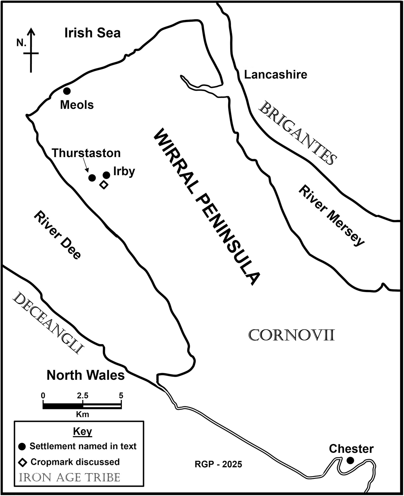
A cropmark with at least one rounded corner and three straight sides, enclosing some four hectares, is visible on Google satellite imagery dated May 2023,Footnote 1 located on arable land at an altitude of approximately 80 m above Ordnance Datum (centred at SJ 2547 8384). The location is near the Dee coastline of the Wirral peninsula, 500 m south-west of the village of Irby and 700 m south-east of that of Thurstaston (Fig. 1). A significant concentration of Roman finds has been recorded close to the feature.
The Wirral peninsula showing the location of the cropmark described and places referred to in the text

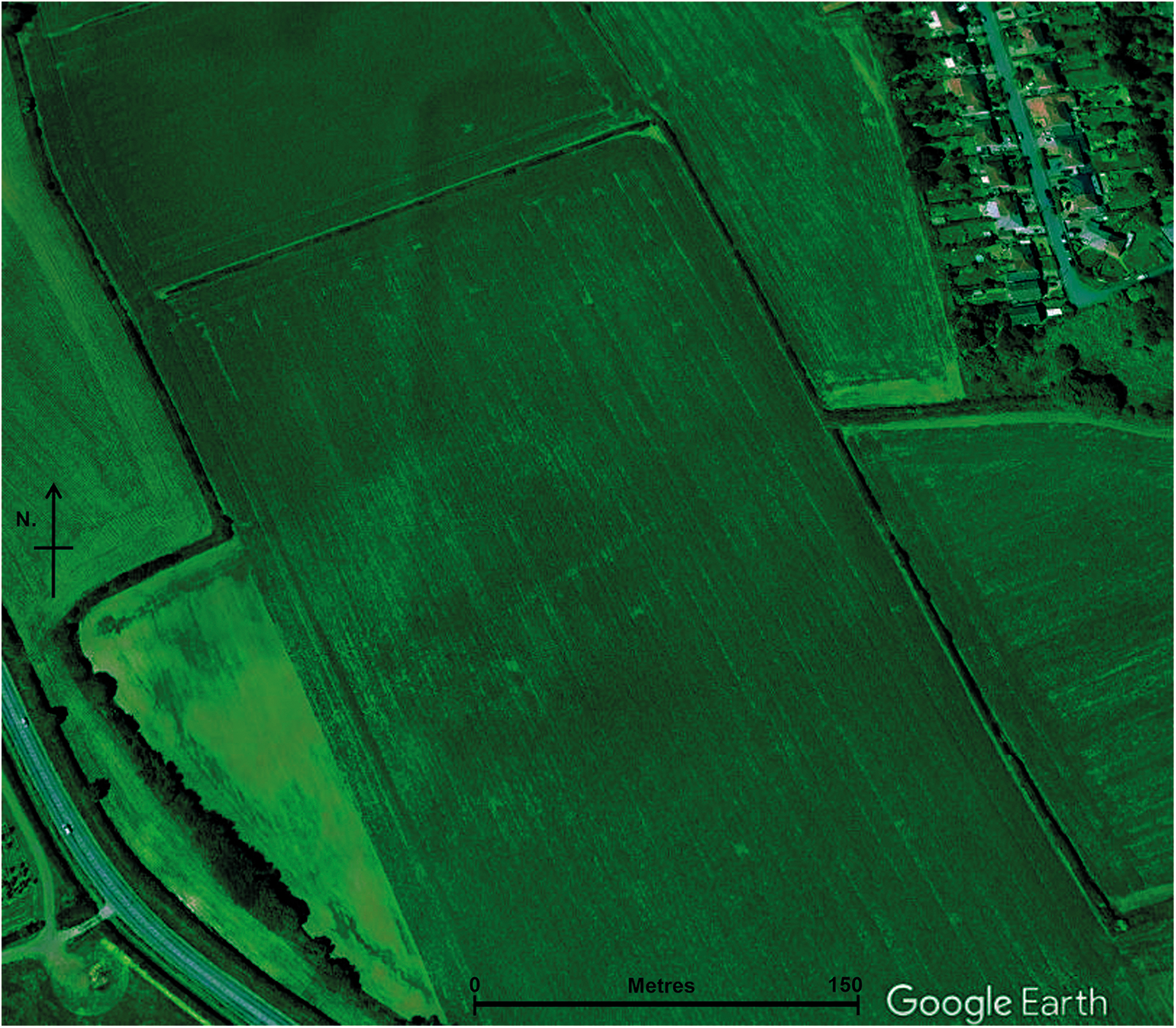
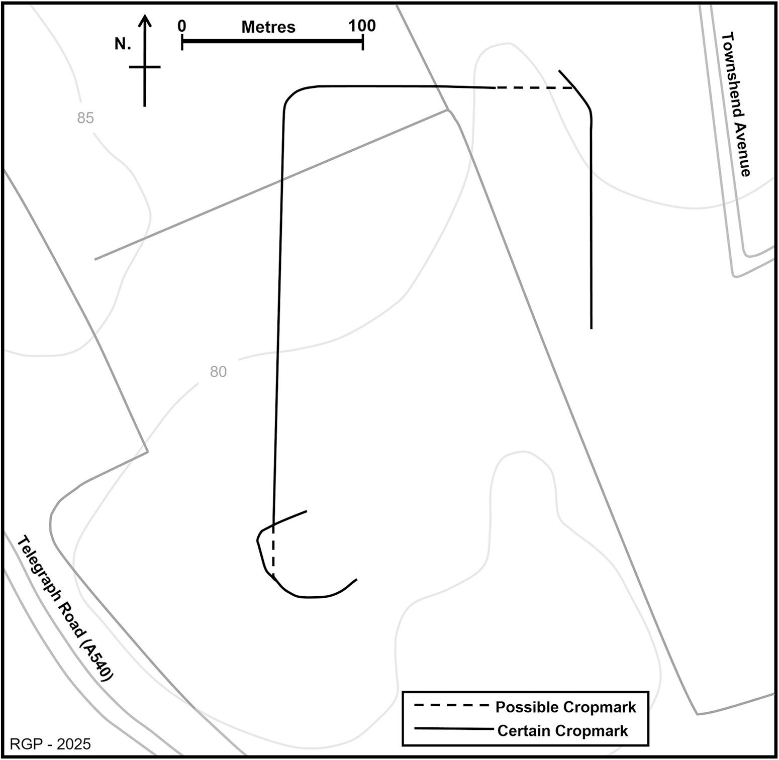
On the west side the cropmark (Figs 2 and 3) shows a north–south orientated ditch running for 240 m; at its northern end it turns through a rounded 90-degree corner and runs east. Crossing a field boundary after 85 m, the cropmark becomes less distinct, yet there are faint indications that this northern boundary continues on the other side of the hedge. The cropmarks on the east side of the feature are not well defined. There may be another corner, but the definition is not clear enough to be confident. Some 130 m of an eastern north–south boundary is visible, following which the alignment is lost.
Google satellite imagery showing the cropmark which has been made clearer by adjusting the colour balance in GNU Image Manipulation Program, version 2.10. (Imagery © Airbus, Bluesky, Infoterra Ltd & COWI A/S, Maxar Technologies, Map data © 2025 Google.)

Sketch map showing the cropmark visible on Google satellite imagery in relation to field boundaries and contours as mapped by the Ordnance Survey

A large rectangular cropmark is thus defined on three sides, measuring c. 270 m north–south by c. 160 m east–west and enclosing an area of approximately four hectares. The feature includes at least one rounded corner of the type typically associated with Roman camps.Footnote 2 It seems too regular to be a coincidence of natural features and an archaeological origin is probable. The feature is visible in three fields and is intersected by boundaries shown on the tithe survey of 1849.Footnote 3 Only the southern boundary and the south end of the eastern boundary cannot be traced.
The western north–south boundary meets an oval enclosure at its southern end, which has been interpreted as an Iron Age farmstead site. This cropmark enclosure is shown on an aerial photograph of 1981, which includes three likely roundhouses in the interior. Fieldwalking over the enclosure has yielded two sherds of Cheshire stony VCP — an Iron Age fabric — along with one possible late Bronze Age or Iron Age sherd.Footnote 4 The field has also yielded Roman pottery, including one sherd from the vicinity of the enclosure. Since no excavation has taken place, it has been noted that there is ‘an uncertain relationship between the enclosure and the occupation material’.Footnote 5
The relationship between the western north–south ditch and the enclosure is intriguing. The ditch runs for 240 m, until it touches the enclosure ditch. It may then run through the enclosure — separating a small portion of its western side — although the cropmarks are too indistinct to be certain. The correlation between these features may not be coincidental. The implication is that a putative Iron Age enclosure formed a visible earthwork when the ditch was created, which suggests an early date for the rectangular feature of which this ditch is a component.
The possible camp may have utilised the probable late prehistoric site, incorporating the curving enclosure ditch into its south-west corner. If this is a camp, then perhaps the enclosure was abandoned in the early Roman period, allowing it to be repurposed. Such incorporation of earlier features into the earthworks of a camp has been noted elsewhere, as at Bromfield, Shropshire, where a Bronze Age barrow was built into the rampart.Footnote 6 However, since the oval enclosure is undated the chronological relationship between the cropmarks remains unclear. No evidence of the possible camp is visible on the 1981 photograph showing the oval enclosure, nor is that feature well defined on Google satellite imagery.
The archaeological potential of the land where the cropmark is situated was assessed in 1992. Roman finds had then been discovered through over a decade of metal-detecting, including twelve brooches of later first- and second-century date, seven coins — ranging from the first to the third century — a key, and a pin. Fieldwalking had also identified 31 definite Roman sherds, along with others of possible Roman date.Footnote 7 Much of the Roman metalwork came from the field 300 m north-west of the possible camp, where a poorly defined rectangular cropmark enclosure is recorded, suggested to be a Roman-period farmstead site.Footnote 8
The 1992 assessment showed that fields in close proximity to the cropmark had produced the greatest concentration of Roman finds from any site in Merseyside except Meols, the location of an Iron Age harbour which was used throughout the Roman period.Footnote 9 Temporary camps generally yield little artefactual evidence, although such sites were sometimes reused by the Roman military.Footnote 10 It is noteworthy that there is a regionally significant density of Roman artefacts from the vicinity of the cropmark described.
Discussion
Roman-era settlement on Wirral is known only from farmstead sites, revealed through clusters of Roman metal and ceramic finds, and through cropmark enclosures.Footnote 11 Such cropmarks are usually interpreted as enclosed farms of Iron Age or Roman date and twelve cropmark sites — possibly of this broad date — have been recorded on the peninsula.Footnote 12
The large rectangular feature identified in the Google satellite image is atypical of Wirral, where no other enclosures of this size and shape are known. Aerial reconnaissance — largely conducted between 1985 and 1996 — resulted in the discovery of a dense cluster of enclosures east of Chester. Fifteen cropmark sites were identified, the closest situated 22 km south-east of the site here described.Footnote 13 These enclosures were described as rectangular, with parallel sides and rounded corners. A Roman military origin was argued on morphological grounds, the enclosures possibly representing practice camps.Footnote 14
Charcoal excavated from the lowest ditch fill at one of these sites returned a radiocarbon date in the Roman period, while at two sites claviculae were visible as cropmarks.Footnote 15 A Roman origin has been suggested for all the enclosures, although, due to their size, Jeffrey Davies and Rebecca Jones categorised them as marching camps rather than practice camps.Footnote 16 Seven more rectilinear enclosures have recently been identified on LiDAR images in the same general area and are considered to be of probable Roman military origin.Footnote 17
Based on its morphology, the site identified on Wirral — like the features east of Chester — can be interpreted as a Roman camp. Cropmark sites have been described as representing probable camps elsewhere, even if known from a single rounded corner, as was the case at Cound Hall, Shropshire, when the site was described by Humphrey Welfare and Viven Swan.Footnote 18 At Glanmiheli, Powys — where a camp has been suggested — the cropmarks do not include a corner.Footnote 19 In the absence of further cropmark evidence or excavation, the suggestion of a camp on Wirral can remain only a possibility, yet this is nonetheless a potentially significant site.
The area enclosed is some four hectares, which is a reasonable size for a marching camp.Footnote 20 Welfare and Swan noted that in England, there is a concentration of camps with areas measuring between 3.1 and 4 hectares.Footnote 21 None of the distinctive types of gate associated with Roman camps can be identified at the Wirral site, although this was also true of most of the Chester sites.Footnote 22 The lack of such features need come as no surprise in an area where cropmark formation is poor. Indeed, Jones has determined that no gates can be identified at 18% of British camps.Footnote 23
No Roman military sites are known from Wirral, yet a camp would not necessarily be unexpected. The peninsula’s northern coastline provided the only seaboard of the Cornovii tribe. Roman military sites were established in the Cornovii’s territory in the pre-Flavian period and the tribe is believed to have surrendered soon after the Roman invasion of Britain.Footnote 24 A wealth of Roman artefacts show there to have been a site at Meols on the north Wirral coast, but its character cannot now be determined due to coastal erosion. In 1863 Abraham Hume suggested that ‘the Roman objects … are … so numerous as to be consistent only with the theory that there was an important station here’.Footnote 25 More recently, Ray Kenna suggested that Meols could have been the site of ‘a signal station or a small fortified post’.Footnote 26
Robert Philpott has suggested that the port at Meols might have provided the Roman army with a strategic location from which military attacks could be launched in two directions: along the Lancashire coast to the north and into Wales to the south-west.Footnote 27 It has been argued that a concentration of pre-Flavian material from Meols, including pieces of a military nature, implies a military presence in the decades immediately following the Roman invasion of Britain.Footnote 28 Philpott proposed that:
While the pre-Flavian artefacts at Meols may be derived from short-lived episodes of activity in response to particular threats, its apparently strategic role in the early military campaigns in northern England and north Wales may have demanded the construction of one or more temporary camps, if not a more substantial fort, to provide protection for the troops and naval personnel. However, the extent of coastal erosion at Meols makes it highly unlikely that the remains of any such installation survive today to settle the point.Footnote 29
The cropmark site identified is in the hinterland of Meols, just 7 km to the south-south-west. Given Philpott’s suggestion that Roman camps might have existed in the vicinity of Meols, it is not unreasonable that such a site could exist in the wider environs of north Wirral, especially if there was a fort at Meols. It has been observed that permanent forts and camps often lie near to each other.Footnote 30
Philpott has also argued that the first-century exploitation of Flintshire lead deposits, on the other side of the Dee estuary, might have been facilitated through connections with north Wirral.Footnote 31 The location of this cropmark site, less than 2 km from the Dee estuary and 8 km from the coast of Wales, is interesting and could plausibly relate to Roman military movements into Wales.
If the rectangular cropmark feature identified in north Wirral forms a coherent archaeological feature, then it requires explanation. The morphology and size of this partial enclosure — which includes a rounded corner — taken in conjunction with the location implies that this could reasonably be a marching camp. It is to be hoped that further cropmark evidence will be identified in future years which might allow the site described to be better understood. If the possibility of a Roman military origin is accepted, this is a potentially important site, the nature of which demands clarification.