INTRODUCTION
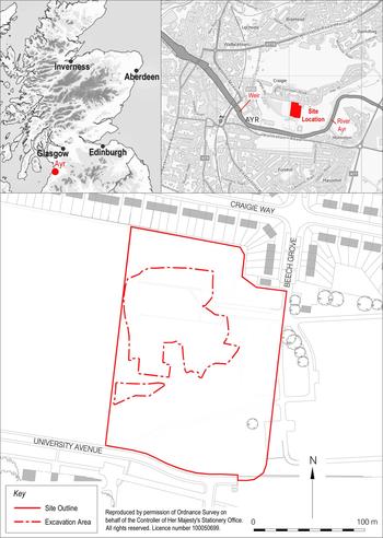
Archaeological fieldwork, undertaken by GUARD Archaeology Ltd, took place in 2015 in Ayr, South Ayrshire on behalf of Kier Construction Ltd. The site (at Ayr Academy) was located 350 m to the north of the present course of the river Ayr at NGR: NS 3509 2156, on a level river terrace formed of raised beach material at c. 20 m OD (fig. 4). During the prehistoric and Roman periods the site would probably have had open views in all directions. Prior to the construction of a weir across the river west of the present site,Footnote 28 the water level would have been lower. There was an easy river crossing just below the site where the sandstone bedrock is exposed.
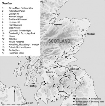
Site location.

THE EVIDENCE
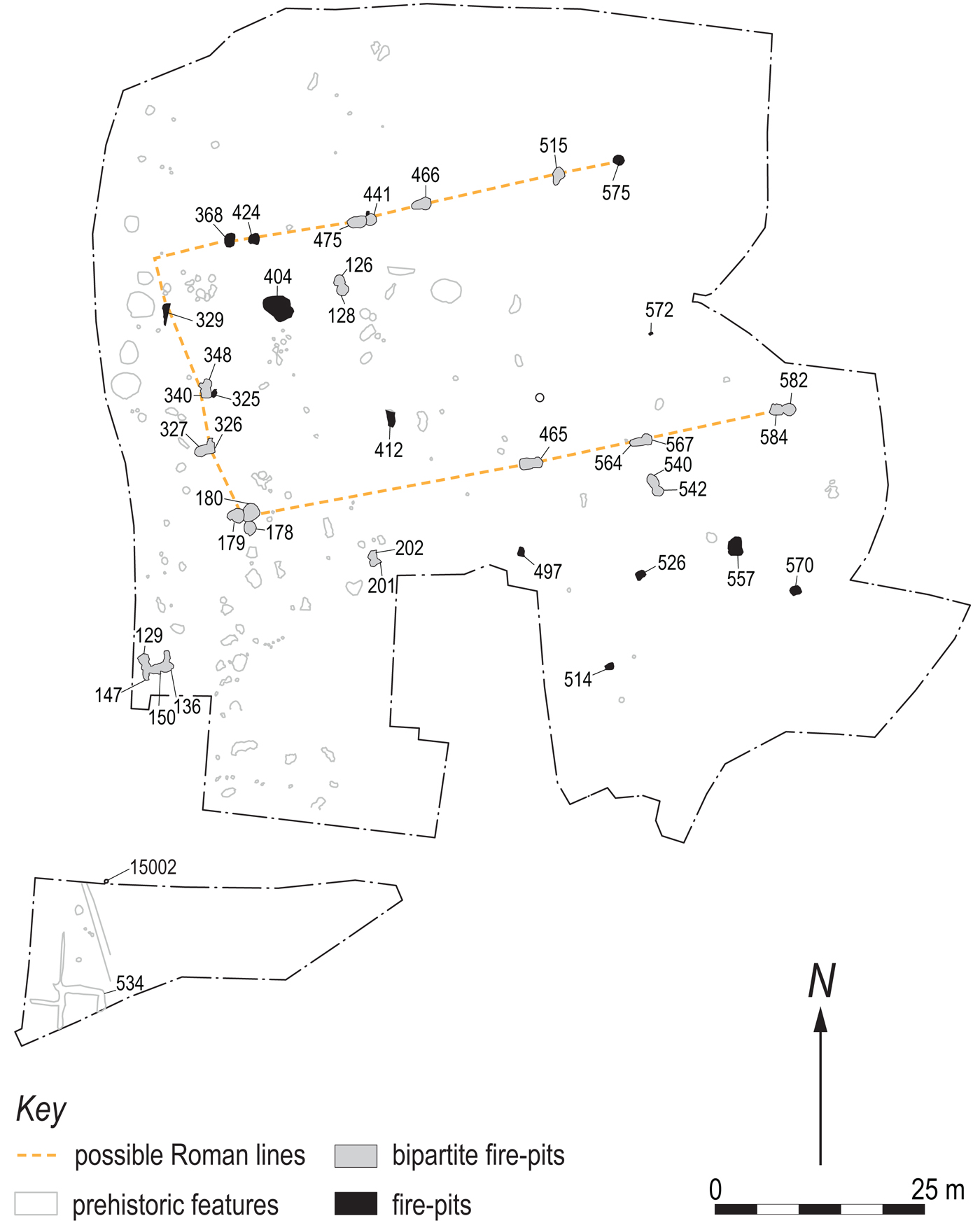
An initial evaluation of the site demonstrated that significant archaeological features were present, and an excavation was subsequently carried out to identify and record the archaeology. During the excavation it became clear that the location provided evidence of several episodes of use. A seemingly random pattern of prehistoric activity was followed by a more structured and defined arrangement of large, often double, fire-pits. These 26 fire-pits are Roman/middle Iron Age in date and are the focus of this paper (fig. 5).
Feature distribution, location of fire-pits and possible Roman lines.

Some of the fire-pits were distributed evenly in two parallel rows, 30 m apart, and aligned north-east/south-west. A shorter alignment of fire-pits, running north/south towards the river, linked the western extremities of the longer rows, and formed one end of a rectangle (fig. 5). The eastern end of the rectangle was not identified as it lay outside the excavated area.
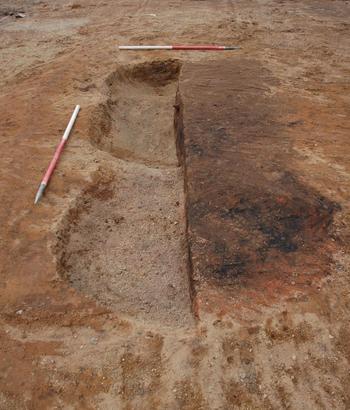
The orientation of the fire-pits in the western row lacked the uniformity present in the other two. Generally, the distance between the fire-pits was 10 m; however, this was variable. Some, like fire-pits 368 and 424, were closer, while others, like fire-pit 465 (fig. 6) and another group of fire-pits 178–180, were more than 30 m apart. The arrangement and uniformity of these features implies an organised layout. Although the size, shape and fill of the fire-pits varied, they were dug in a comparable manner, and the evidence suggests that they were used for similar purposes. They are described in detail below.
Excavation photo of fire-pit 465 from east.

FIRE-PITS
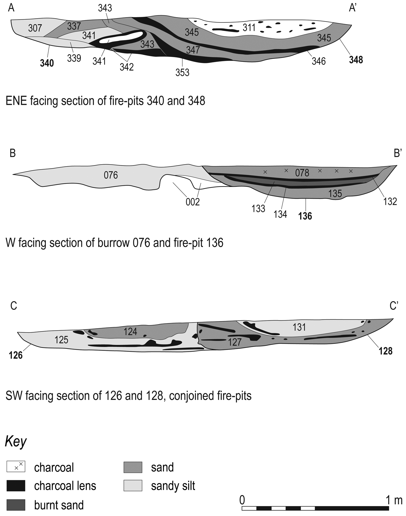
Most of the fire-pits were dug into the natural sand and gravel subsoil in the shape of a figure-of-eight, with measurements ranging between 0.52 and 2.8 m in length and 0.4 and 1.87 m in width. They survived in depth between 0.05 and 0.7 m (online table 1). Bipartite fire-pits are usually thought to have been field ovens, with one end identified as the (open) ash pit and the other as the (covered) oven or hearth.Footnote 29 While most figure-of-eight features showed a distinct functional difference between the ash pit and oven ends (e.g. 126/128 (fig. 7), 201/202, 326/327, 340/348 (fig. 7), 441/475, 465 (online fig. 1), 540/542, 564/567 and 582/584 (fig. 8)), some fire-pits, like 466 and 515, were less well-defined (online fig. 2).
Section of fire-pits 126/128, 136 and 340/348.

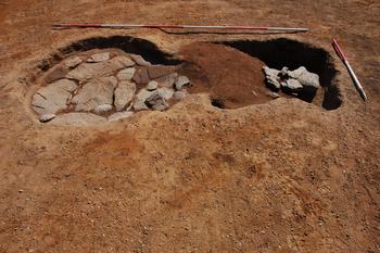
Stone-lined oven 582 and ash pit 584 with rake-out material.

Ovens
The location of the oven or hearth in most of these features was recognised by the scorching of the subsoil base to an orange/red/brown colour. Some of the ovens contained charcoal-rich deposits, possibly remains of in-situ firing; these were identified in the bases of fire-pits 136 (fig. 7), 178, 325, 348 (fig. 7) and 466 (fig. 9). In general, deposits of alternating charcoal lenses and scorched soils were recorded filling them. Sealing them all, and interpreted as backfilling material, was a coloured sandy silt.
North-facing section of fire-pit 466.

Ovens were generally positioned at the east or south end of the features. There were two exceptions, fire-pits 129 and 348 (fig. 5), which were orientated to the north. Both of these were part of a bigger group, where an additional firing area was present to their immediate east.
Burnt clay fragments were noted in fire-pits 178, 326, 404 and 424. This material could indicate either that the pit was lined, or that it contained the remains of demolished oven superstructures. This idea is further supported by wood imprints in some of the clay pieces and their dome- or concave-shaped moulding. While some fragments were retrieved from within burnt deposits (e.g. 110 and 304), others were mixed within the upper fills of pits (e.g. 393). The latter were thought to be the remains of a destroyed or dismantled oven, deposited through backfilling.
Ash pits
Ash pits were identified at the opposite end to the ovens within the figure-of-eight features. They were often more elongated than the ovens and tended to be rectangular in shape. They were filled with a mixture of burnt soil and charcoal-rich deposits comprising raked-out material from the oven or hearth end. This material was often concentrated near the oven and was not evenly spread across the ash pit. In general, backfill material overlay the raked-out deposits. In most cases, both ends of the figure-of-eight features had flat bases and were similar in depth. However, the depth of some of the ash pits — fire-pits 180 (see below), 348 (fig. 7) and 465 (online fig. 1) — was deeper than their associated ovens (online fig. 3; see online table 1).
Detailed fire-pit examples
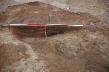
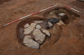
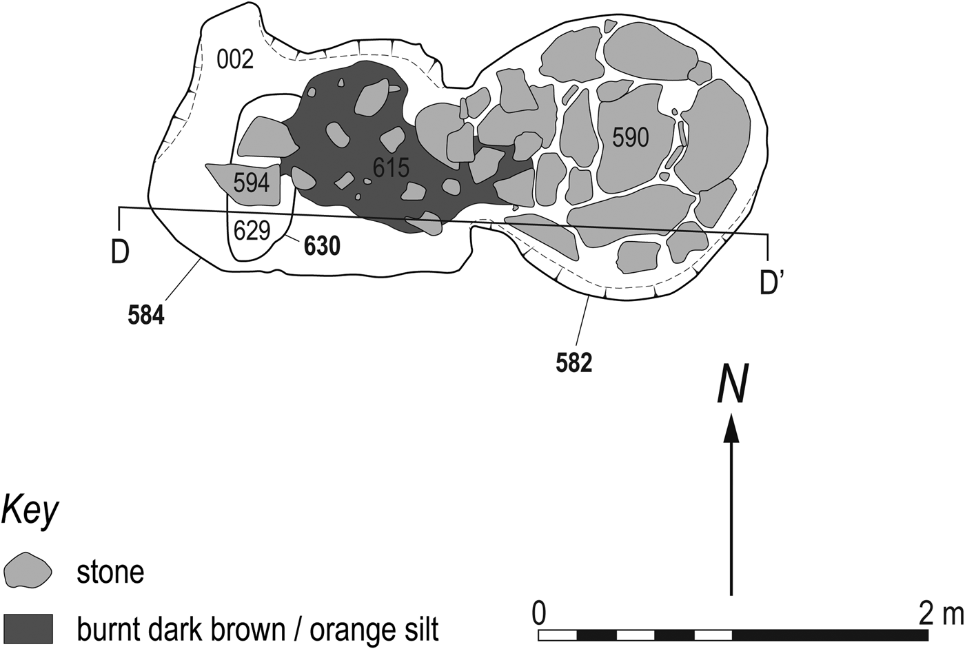
The most elaborate of the fire-pits and the only one with a dry-stone lining was 582 (figs 10–11), located in the eastern part of the site. The sub-circular and unburnt lining survived at the base of the oven as a single course of angular slabs of sandstone, mudstone and siltstone of varying shapes and sizes (590). The lining measured 1.68 m in length by 1.32 m in width and survived 80 mm in height. A charcoal-rich orange and grey silty deposit (597) between the stone was subsequently overlain by a thin layer of dark brown/orange silt with charcoal flecks (581). This sequence and the oven were covered by dark grey/brown silt (fig. 12).
Stone-lined fire-pit 582/584 and 630.

Excavation plan of fire-pit 582/584 and 630.

South-facing section of fire-pit 582/584 and 630.

The adjacent ash pit (584) on its west side was roughly square in shape, measuring 1.5 by 1.4 m, with steep sides 0.35 m in depth, leading to a concave base. Several charcoal-rich fuel waste deposits, similar to those in oven 582, were identified within it but concentrated at the junction of the two pits. Sealing the feature was a layer of dark grey/brown gravelly silt with charcoal flecks (583). This deposit was similar to the one used to backfill oven 582.
A roughly rectangular dry-stone structure (594), 0.4 by 0.28 m and 0.13 m in height, built of mudstone or siltstone blocks, was observed in the pit among the backfilling material. It was constructed on top of two stone slabs covering an earlier feature (630) located below the centre of pit 584. The function of this structural arrangement is unclear but it could have been built to stabilise the soft sandy silt deposits infilling pit 630.
Other large fire-pits (404 and 178–180)
The largest fire-pit on site (404) was roughly oval in shape. It measured 2.8 m in length by 1.7 m in width by 0.5 m in depth. Its flat base was filled with burnt sand (423) and burnt sandy clay (403), with clay fragments identified on its north-east edge (online fig. 4). Additional greyish/white clay patches were recovered overlaying these deposits.
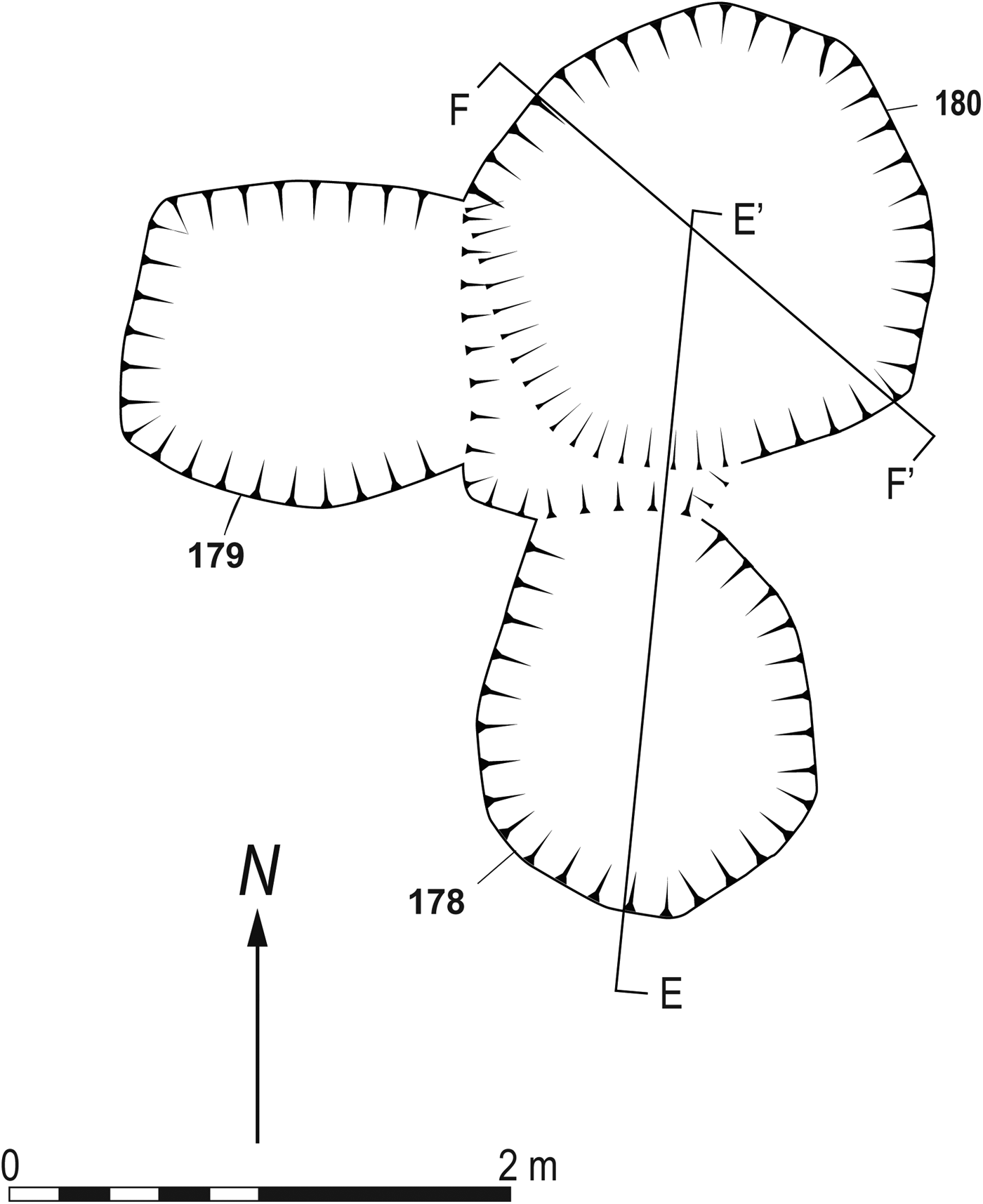
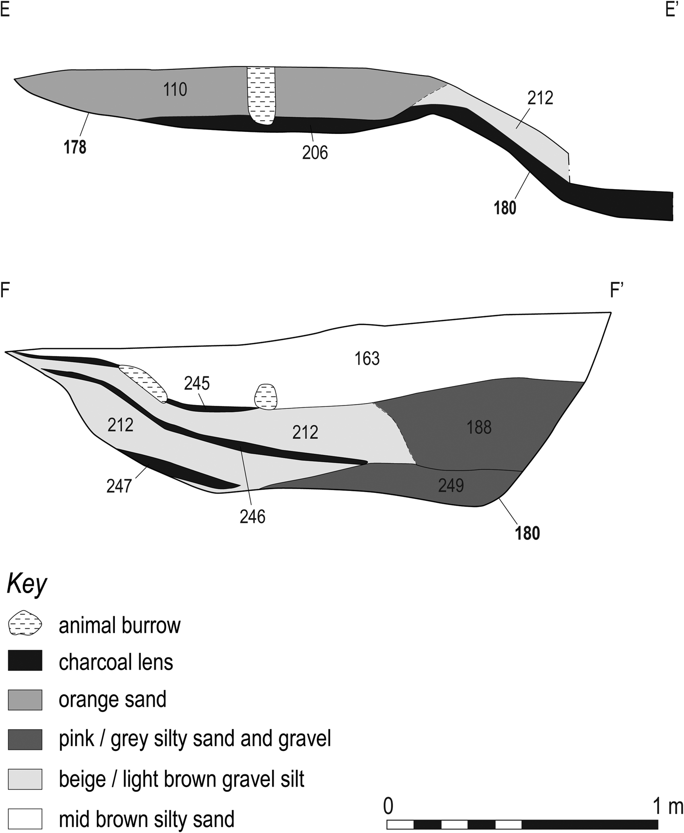
Pit 180, one of a group of three fire-pits (178–180), was the only pit with datable finds (figs 13–14). Located at the west side of the excavation, it was the deepest pit on site, and was intimately associated with two ovens (178–179). The presence of the latter was probably the cause of the 0.7 m depth of ash pit 180; otherwise, it measured 2 m in length by 1.87 m in width. Similar examples with deeper pits were noted in Kintore.Footnote 30 A primary fill of firm pink/grey/brown gravel and silt 0.14 m thick was identified at the north end of pit 180 indicating that it had been left open prior to being filled by burnt waste material from fire-pits 178–179. This material comprised several deposits of charcoal (245–247), alternating with loose beige/light brown gravelly-silt (212). Abutting all fuel waste material, a firm pale pinkish/grey silty sand with gravel was recorded. Finally, a firm moist mid-brown silty sand (163) covered the rest of the ash pit. The silting identified intermingled between the charcoal layers, suggested that either there had been several uses of this pit, with a period of inactivity, or a collapse of its sides.
Post-excavation plan of fire-pits 178, 179 and 180.

Sections through fire-pits 178 and 180.

Other smaller fire-pits
Most of the smaller fire-pits were located towards the south-east. They were single oval fire-pits measuring between 1 and 1.4 m in length by 0.7–1.25 m in width and 0.07– 0.25 m in depth. They were smaller versions of the figure-of-eight fire-pits with an ash pit in one end and a possible oven at the other (online fig. 5). In contrast to the larger fire-pits, the location of the fire was inconsistent and the pits were not placed in rows and did not form a recognisable pattern. However, the composition and distribution of their deposits was similar to those fire-pits already described, with a mixture of fuel waste, scorched soil and backfill material forming their infill.
FIRED CLAY EVIDENCE By Beverley Ballin Smith
A total of 28 pieces of fired clay fragments weighing 176.2 g were recovered from pits across the excavated area (online table 2). The clay was largely raw clay, most likely dug from the banks of the river Ayr, to which some gravel had been added as a strengthener and organic material mixed in to make the clay more pliable. It was not pottery, but it had been used in an unfired or unburnt raw state as a constructional material, together with withies and hurdle-type wooden constructions, where its main function was as an insulating and infilling material. The natural colour of the clay was grey/yellow to buff, which changed to orange/red when burnt.
Several fired clay pieces retained evidence of wood impressions: SF 82 and 83 from fire-pit 326, SF 86 from fire-pit fill 304, and sample 216 from fire-pit 404. The large, irregular piece from SF 83 may have been pressed against a piece of sawn timber and SF 83 included a piece that was partly shaped around a small diameter twig and had adhering charcoal. The piece from SF 86 contained a large amount of stone and its dome/concave-shaped moulding indicates it may have lined a pit or formed part of the superstructure of an oven.
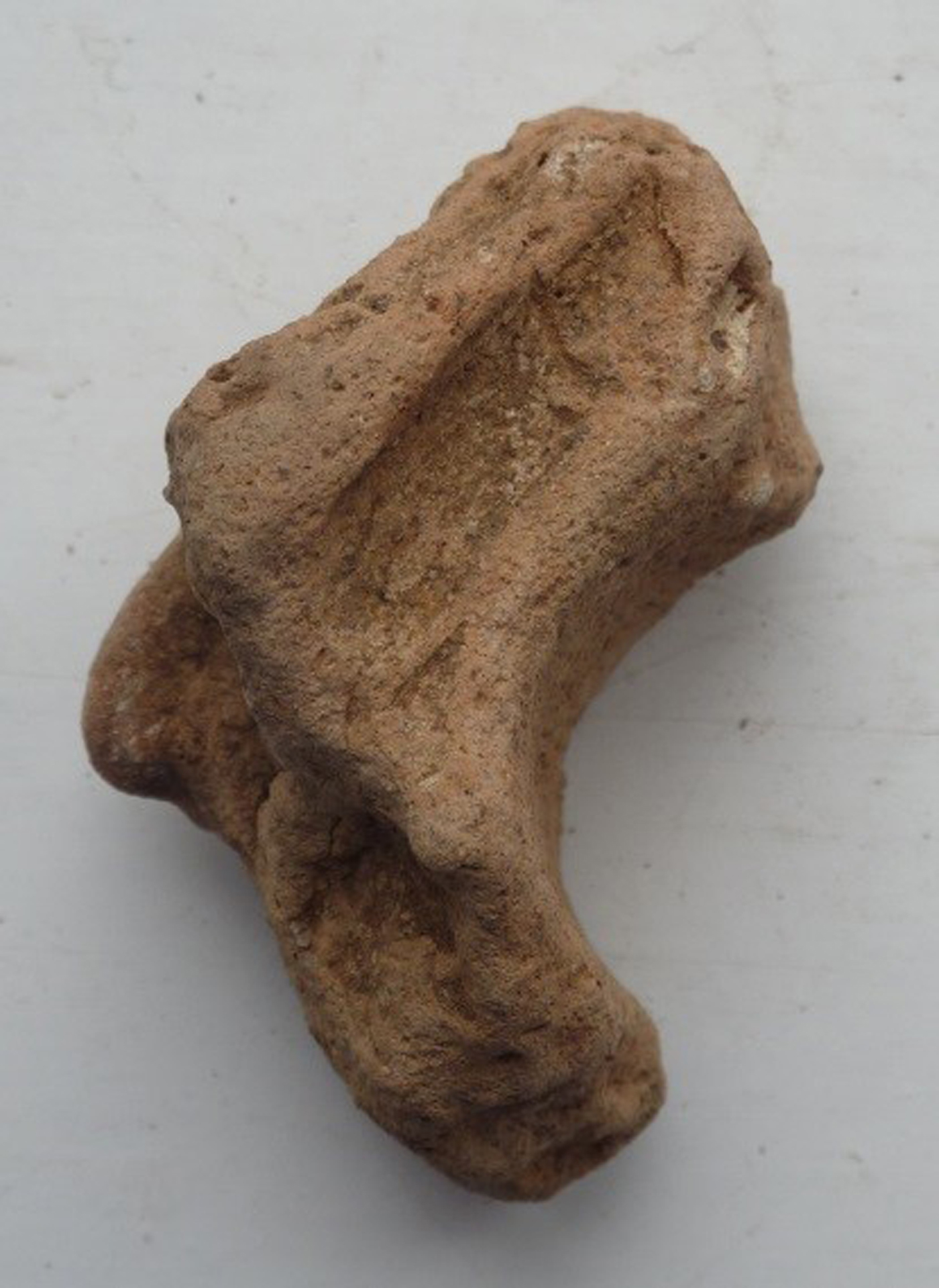
A piece from sample 216 (fig. 15) is the most informative of the assemblage. It is irregularly shaped, with a 25-mm diameter curve from a branch and adjacent to it a smaller impression measuring 6.5 by 2.5 mm, indicating the use of branches of various thicknesses for construction. The sample was found in the fill of the largest fire-pit of the excavation (404) situated centrally but towards the west side of the site. Although only 32.3 g of daub (fired clay) were found in this fire-pit fill, its occurrence indicates there was an oven nearby, which was dismantled or destroyed and from which the debris was either dumped or burnt in fire-pit 404.
Fired clay from fire-pit 404.

What differentiates the fired clay of these pits from prehistoric examples on the same site are the more noticeable amounts of stone in the clay mix (stone is visible in the example in fig. 15), the paler colours of the pieces, the harder fabric and the survival of shaped or moulded pieces. Fire-pits 326 and 404 produced fragments that been moulded around twigs, small branches and sawn timber. The two larger fragments from fill 304 of fire-pit 326 were dome-shaped and were possibly surviving parts of the light-weight wooden oven superstructure that was daubed inside and out with clay. On breaking camp the ovens would have been destroyed and only those pieces that were well-burnt have remained to provide evidence of the specific use of these features.
BOTANICAL ANALYSIS OF THE PIT FILLS By Diane Aldritt
Botanical analysis of the fire-pit fills indicated the use of woodland resources, which included scrub types of wood, peat and heathland, as fuel. The fire-pit fills tended to produce mixed fuel waste deposits consisting of oak, hazel, alder, birch and occasionally Prunoideae (blackthorn) and Maloideae (apple/hawthorn/whitebeam) types. Fire-pits on the east produced some good concentrations of well-preserved charcoal, often in quite large amounts. Fire-pits 540 and 582 contained slightly larger ratios of oak to non-oak types and could more specifically be ovens with material burnt in situ.
It is quite possible that much of the charcoal was moved from pit to pit, re-deposited as rubbish and layered with each new fire, with some spread out as over-spill or swept out, producing decayed and highly crushed fragments, and mixed deposits of different fuel types (see fig. 7).
Fire-pit 582/584
Botanical analysis of the lowest organic deposit (597) recorded between the stones forming the lining of oven 582 indicated that hazel and willow wood was burnt on top of them. Hazel charcoal from this deposit was submitted for dating. The sample consisted of a well-preserved fragment of small branch roundwood with three growth rings and the bark still attached; it is possible this was from a collection of small tinder branches being used to start a larger oak fire. This deposit gave a radiocarbon date of 52–214 ad cal (see online table 3). The adjoining ash pit (584) to the west was filled with fuel-waste material, possibly raked out from oven 582.
Fire-pit 404
Some pit fills produced grain, mostly barley, even though in small traces. The largest cache of carbonised grain (51 barley grains) was found in fire-pit 404. Most were in quite poor condition suggesting that they had possibly been re-deposited from elsewhere or burnt at high temperatures. Dating of barley grain from the fill (403) revealed a date of 1660–1507 cal bc (SUERC-67758) firmly placing this activity in the middle Bronze Age (see online table 3). It is possible this represented later re-use of an early pit, with the grain being processed elsewhere on site and the waste deposited there. Pit fill (393), also from fire-pit 404, showed slightly better levels of preservation and had 38 barley grains with a further 12 identifiable as the naked type.
Fire-pit 514
A single Triticum spelta (spelt wheat) was found in the fill (510) of fire-pit 514. Moreover, mixed charcoal of oak, hazel, alder and willow interpreted as fuel-waste material was identified in this pit. Hazel charcoal from the fill was submitted for radiocarbon dating and produced a date of 81–231 ad cal indicating middle Iron Age or Roman activity.
Fire-pit 326/327
Cereal grain was present in oven 326 along with oak, hazel and birch charcoal and some heather stems, but only in very small trace amounts. A single well-preserved grain of Hordeum vulgare var. vulgare (six row hulled barley) was found together with one less well-preserved grain of barley type.
Fire-pits 526, 540/542 and 564/567
Barley was present in the fill (524) of fire-pit 526 but was too poorly preserved to identify further, with a single degraded barley grain also in the fill (530) of oval ash pit 540. A single hulled barley grain was found in the fill (538) of oven 567.
The increased presence of heath and peat-land indicators during this phase may be directly related to the presence of cereal grain at the site, with waste fuel from cereal drying or domestic cooking activities deposited in the pits. In general, the combination of wood charcoal types, heath and peat-land indicators, and cereal grain recovered point to Middle Bronze Age as well as Iron Age/Roman activity.
DATING
Most of the datable samples produced radiocarbon dates of the middle Iron Age or Roman period, a time when such information is relatively sparce in south-west Scotland.
Samples selected for radiocarbon dating were of short-lived species including alder, hazel and birch and there was one sample of carbonised cereal grain. Six samples selected from fire-pits 126, 180, 514, 582, 585 and 630 returned Roman dates (online table 3). The results of the other two samples, from pits 180 and 404, were problematic. A late Bronze Age date obtained from fill 163 of ash pit 180 appears unreliable. An additional date attained from an earlier fill (245) within the same pit returned a Roman date, suggesting that the earlier date is the result of either residual charcoal or contamination through ploughing and/or re-digging of earlier features. The middle Bronze Age date obtained from the carbonised cereal grain in fill 403 of fire-pit 404 also suggests either contamination or intrusion. Although Roman in date, the result obtained from pit 630 could also be unreliable. The presence of coal in the fill could indicate later intrusion which could have been facilitated by the digging of ash pit 584 just above it.
The radiocarbon dates from six of the fire-pits provided evidence of use ranging from c. 2 bc to 231 ad cal, with most overlapping around the Flavian period between a.d. 77–86 and 90 (online table 3). No finds datable to this period were recovered in any of the fire-pits on the site. The closest find contemporary to the Flavian period, and found west of the site in Ayr, was a Roman coin forgery of a sestertius of Domitian.Footnote 31 The only datable finds recovered from any of the Ayr fire-pits themselves were encountered in the fill of ash pit 180, which was stratigraphically linked to two ovens, 178 and 179. The upper fill (163) contained a rim from a Bronze Age pottery vessel (SF 29), a fragment of a shale bangle (SF 31) and a fire-cracked stone (SF 74). An edge retouched lithic tool (SF 73) was found in context 212, a silt deposit below 163 and between two charcoal lenses.
Two samples for radiocarbon dating were submitted from this ash pit (see online table 3). Context 163, the upper fill of the pit, provided a late Bronze Age date of c. 1123–969 bc cal. However, the upper layer (245) of a series of charcoal lenses situated below the previously dated deposit (163), produced a middle Iron Age/Roman date of c. 2 bc–125 ad cal. This inconsistency of dates is most likely the result of intrusive or residual charcoal introduced through the digging of the pit or through its backfilling.
DISCUSSION
MARCHING CAMPS AND FIELD OVENS
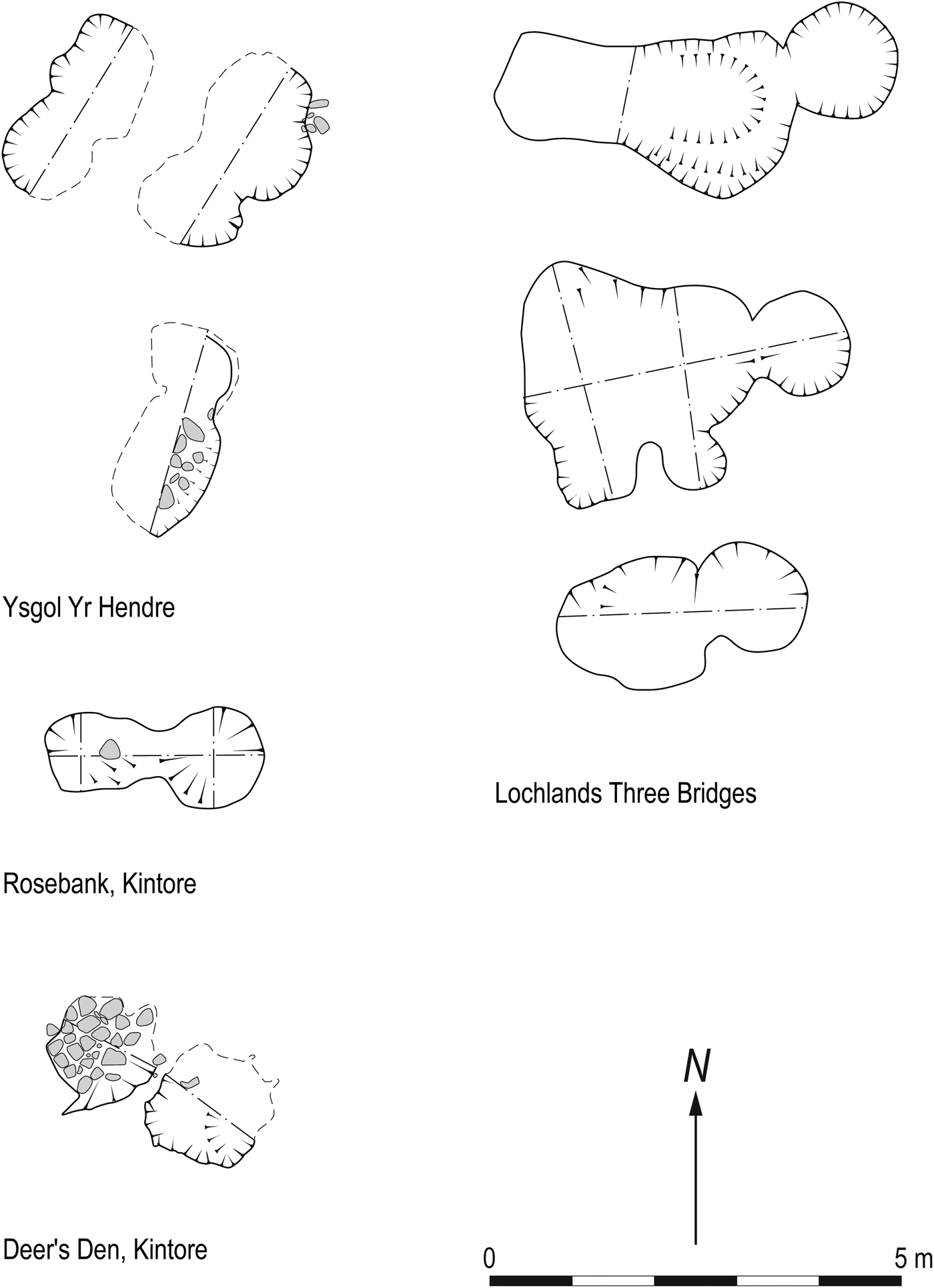
Similar fire-pits to the ones found at Ayr Academy, recognised as field ovens, have been identified across Scotland. The most significant ones were identified during the excavation at Kintore Roman camp, where c. 116 field ovens were recorded along with other features.Footnote 32 Most recently, a total of 90 ovens dated a.d. 83–84 have been discovered at Milltimber, Aberdeenshire.Footnote 33 Comparable fire-pits, but in fewer numbers, were found at Melville Nurseries, Dalkeith, MidlothianFootnote 34 and at Howe Mire, Musselburgh, East Lothian.Footnote 35 At the latter site, the features identified as ovens were associated with a Roman temporary marching camp, and dated to the first and early second centuries a.d. A separate example in Wales from the excavations at Ysgol Yr Hendre, Llanbeblig, Caernarfon, produced 26 field ovens and associated pitsFootnote 36 (fig. 16).
Comparative plans of other fire-pits across Britain.

In Kintore, all the Roman fire-pits were located within the limits of the marching camp ditch. In Dundee High Technology Park, Tayside, similar undated features were discovered outside, i.e. c. 700 m north of, the known camp at Invergowrie.Footnote 37 Two dated pits at Melville Nurseries were located 500 m west of Elginhaugh, a Flavian fort.Footnote 38 As at Ayr Academy, there was no evidence of a ditch defining the camp at Ysgol Yr Hendre, Wales.Footnote 39 Its absence within the excavated area could imply that the ditch might have been located in the vicinity of the site but was not revealed during the excavation. This lack of an associated camp ditch was also noticed during the recent excavations at Milltimber, Aberdeenshire.Footnote 40
The investigated area at Ayr Academy covered c. 0.7 ha. Considering that the size of identified camps can range from less than 0.1 ha to up to more than 65 ha,Footnote 41 it is possible that the excavation of the Ayr Academy site only exposed a portion of the camp as there is more flat land to the north, where the modern race course is situated. However, there are other possible scenarios that could explain the absence of a ditch. Excavation near Hadrian's Wall revealed a Roman camp at Haltwhistle, where no ditches were found. There are references to camps without ditches, but with palisades and/or earthworks instead as forms of defence, in classical Roman sources.Footnote 42 However, the strength of defences was also dependent on the enemy's proximity and whether the camp was located in friendly or hostile territory.Footnote 43 Moreover, the meandering river Ayr could have provided a natural defence along the camp's south and east side, limiting the need to create defences. It is possible to argue that subsequent landscaping or ploughing of the area, either for agricultural purposes or as part of the construction of Craigie Park, could have destroyed any associated palisades and/or earthworks. Another possibility is that an earthwork or a ditch might have been destroyed or backfilled by the Romans themselves when the camp was abandoned, as was customary according to some ancient authors.Footnote 44 However, no archaeological imprint survived in the subsoil to provide evidence of a ditch or other defences.
When compared with other excavated sites, there is a remarkably high number of ovens at the Ayr Academy site. Camp I at Inveresk, an area of 6,700 m2, produced six ovens, while at Kintore one oven was encountered per 795 m2.Footnote 45 At Ayr Academy, there was one oven per 269 m2 (26 ovens in c. 7,000 m2). It has been suggested that this disparity in the density of features reflects the duration of occupation.Footnote 46 The fact that some were fired regularly or on several occasions, is demonstrated by the layering of burnt/charcoal deposits prior to backfilling. The time lapse between each firing is, however, unknown. Ovens could have been fired daily or weekly. Moreover, the high density of pits could also be a reflection of the frequent use of the area, probably due to its strategic location — close to the sea, the river and possibly Roman roads or route ways (fig. 17).
Distribution of similar archaeological sites and Roman roads.

SITE CONTEXT
The dating and archaeology of the pits indicate that the area had been used as a marching camp in the middle Iron Age/Roman period. Marching camps have been described as ‘temporary bases of a tented army on campaign or manoeuvres away from their base’.Footnote 47 Tacitus writes that in the fifth year of his campaign, Agricola along with his forces was facing Ireland, which implies that he was most likely somewhere along the west coast of Scotland, probably the Mull of Kintyre, Portpatrick,Footnote 48 or the coast of Ayrshire or Galloway as argued by Hanson.Footnote 49
The position of the site on a flat river terrace away from the flood plain is probably one of the factors that explains its specific location. Rivers, as well as the sea, were the main communication route-ways. The presence of a river crossing to the south of the camp site could have facilitated communication overland to other Roman camps in the area or to the coast and possible harbour at Ayr or at Troon. Many of the camps found in south-west Scotland favoured the coast or river estuaries, which they often faced. For instance, the two known temporary camps in Girvan overlook the North Channel, while other coastal camps are recorded on the north side of the Solway Firth.Footnote 50 Jones also refers to a possible beaching point, previously claimed as a harbour, at Hunterston Sands.Footnote 51 In the sixth year of his campaign in Scotland, Agricola combined the force of his fleet and army for his advance north of the rivers Forth and Clyde.Footnote 52 The location of a camp at Ayr Academy would have facilitated the gathering and meeting of sea and land forces.
There is a layout and orientation of possible tent lines identifiable at the site in Ayr. The majority of the fire-pits are in a rectangular formation, shaped by two parallel rows of fire-pits running roughly east/west and a shorter row on the west side aligned north/south (see fig. 5). A similar formation was also identified in Field A at Kintore, reflecting the planning and uniformity of the camp layout. It is arguable that each contubernium (group of eight men) would occupy the same or a similar place in each camp they occupied. Recommendations given by the De munitionibus castrorum regarding the location of various units in the camp were similar to the positions that these units formed on the line of march.Footnote 53 According to Hyginus, the basic pedaturae or area allocated to a legionary centuria for tents is 120 ft by 30 ft (a Roman foot is equivalent to 296 mm).Footnote 54 These measurements compare well to the rectangular shape formed by the fire-pits, particularly the width of 120 ft (35 m) (fig. 5). The full length of the rows was not exposed as it was outside the excavated area, but its minimum measurement of 65 m could be indicative of the 264 Roman feet (78 m) needed for all 10 tents of a century and the centurion's tent.Footnote 55 However, these measurements should not be taken as a rigid rule, since variations most likely occurred according to the terrain.
CIRCUMSTANCIAL EVIDENCE OF A POSSIBLE ROMAN ROUTE?
By definition, no roads were built between temporary marching camps but it may be worth assessing the evidence for roads that may at some point have connected permanent installations in the area. The closest possible known Roman road is 3 km south-east of the site in Dunston Hill.Footnote 56 Its north-west/south-east orientation suggests a possible route towards Knowe Cottages camp or Bankhead Kirkconnel camp.Footnote 57 Further south another possible road orientated north-east/south-west was identified at Kirkmichael Parish.Footnote 58 This road could connect the camp at Ayr Academy to the two known temporary Roman camps found at Girvan Mains, Girvan.Footnote 59 Moreover, the distance between these camps (Girvan and Ayr Academy) of 16–20 miles corresponds to a day's march.Footnote 60 In addition, there are suggestions that the presence of a Roman road at CastledykesFootnote 61 leading towards Loudoun Hill implies a route west to the coast; possibly to the mouth of the river Ayr or to a possible harbour there or at Troon.Footnote 62 There are two likely camps on this route: at High CauldcoatsFootnote 63 and West NewtonFootnote 64 (fig. 17).
STRUCTURE AND USE OF THE FIRE-PITS
All the features interpreted as field ovens were defined by an area with evidence of scorching and another with layers of charcoal and/or burnt raked-out material. Most of them were bipartite in form with the two areas clearly demarcated.
No phasing was evident across the fire-pits. The lack of intercutting and their methodical distribution suggests that they were either dug at the same time or were visible when they were excavated. At Ayr Academy, most of the fire-pits are orientated to the east with some exceptions. The same orientation of fire-pits was observed at Kintore as well as in Lochlands, Three Bridges.Footnote 65 The exceptions to this alignment could imply different phases of occupation of the temporary camp, or the influence of the prevailing wind.
In bipartite pits, the fire would have been lit in the oven using local woodland resources. The presence of moulded fired clay in two of the fire-pits indicates that some of the ovens were roofed by a wooden framework lined with clay. Evidence of similar roofed structures was present in Forest Road, KintoreFootnote 66 and Ysgol Yr Hendre, Llanbeblig, Caernarfon.Footnote 67
The ash pit, the second part of the bipartite pit, was filled with the rake-out material gathered after the fire-pit or oven was cleaned. As suggested by the analysis of botanical remains, much of the charcoal recovered from these pits was redeposited. The ash pit was often deeper than the oven, possibly to facilitate access to the oven to build it up, to clean and/or use it.
The ovens were most likely used for domestic cooking (perhaps in particular the baking of bread) or cereal drying; however the scarce amount of cereals found within the different fills suggests that they were not used as corn-driers. Moreover, the lack of artefactual remains leads us to speculate that they did not fulfil other functions, such as the manufacture of metal or firing of pottery. In general, finds from fire-pits are also rare at similar sites. Melville Nurseries, Eskbank, did not have any finds,Footnote 68 and only barley was found as part of the cereal assemblage in a possible Roman pit at Dalkeith Northern Bypass.Footnote 69 Earlier excavations in Lochburn Drive, Kintore, revealed a flint core in the fill of a fire-pit, although metal finds were found later in some of the pits. Leslie argues that the lack of, or the small number of finds, discovered in these temporary camps is due to their short-lived occupation.Footnote 70
A wide range of fuel, including more open and scrubby types of wood together with mixed deciduous oak woodland, but also utilising peat and heathland resources, was used at the site at Ayr Academy. The mixed nature of the fuel indicates open woodland, which would have aided visibility around the surrounding landscape, making this camp easier to defend.
Cereal grain was found in six of the pits, and included small trace amounts of barley, hulled barley and spelt wheat. In general, the low quantities of cereal grain and scarce traces of weed seeds found in the environmental samples are indicative of the scrubby woodland area the camp was situated in. The finding of spelt wheat in a context dated to the middle Iron Age or Roman period is highly interesting. Although this type of wheat was grown in parts of northern England and Scotland during the late Iron Age, its increased presence later on could have been influenced by the food requirements of the Roman army. Spelt wheat could have been imported from further south or been grown locally as food for the Roman army at this time.Footnote 71 The scarcity of charred cereal grains was noted at all comparable sites, and it was particularly apparent at larger sites such as Forest Road, KintoreFootnote 72 and Ysgol Yr Hendre, Llanbeblig, Caernarfon.Footnote 73 The small quantity of cereal has been interpreted by different authors as an indication that the ovens were used for baking bread and cooking and not for cereal drying or processing, as this function would produce larger quantities of cereal grains.Footnote 74
CONCLUSION
The discovery of Roman fire-pits at Ayr Academy is highly significant, not only because it is direct evidence of a Roman presence in the area, but also because, circumstantially, its location indicates a route used by a marching army. The camp could have been close to routes to the sea and inland as well as north–south routes.
The topography, on a raised beach with well drained ground and the natural defence given by the river Ayr, which frames the site at its east, south and west sides, was the main factor when choosing this location. Other similar sites are also located in comparable topographical and geological settings, such as Deer's Den (Kintore), Aberdeenshire.Footnote 75
The discovery made at Ayr Academy is of national importance. Firstly, it is an addition to the archaeological corpus in the south-west of Scotland, an area quite bare of known Roman sites. Secondly, it gives an opportunity to understand the landscape and its use, not only in relation to this site, but also in comparison with others. The impact of the Roman army on south-west Scotland and Ayrshire in particular has seen limited research, with the 1930s excavations at Loudoun Hill Roman fort and a known temporary camp at Girvan providing little environmental information.Footnote 76 As such, botanical evidence and the radiocarbon dating of the Ayr Academy site are of regional and national significance.
SUPPLEMENTARY MATERIAL
For Supplementary Material for this article please visit https://doi.org/10.1017/S0068113X19000059.
Note the Supplementary Material includes online tables 1–3 and online figs 1–5.
ACKNOWLEDGEMENTS
Kier Construction Ltd commissioned GUARD Archaeology Ltd to undertake archaeological work at Ayr Academy, Ayrshire and they are to be thanked for their assistance during the excavation. Botanical analysis was undertaken by Diane Alldritt. Fired clay analysis was carried out by Beverley Ballin Smith. Thanks to all who assisted in the field: Johnnie Atkinson, Alan Hunter Blair, Richard Campbell, John Gillen, Stephanie Glover, Kenny Green, Daniel Kennedy, Maureen Kilpatrick, James McGovern, Stuart Paterson, Christine Rennie, Beth Spence, Juan Ignacio de Vicente and Erica Villas.