

Introduction
The Maya collapse of the Terminal Classic Period (ad 780–1000) was a complex process that left tangible marks on all aspects of Maya society. During this time period, ancient Maya society underwent a series of dramatic changes marked by declining production of hieroglyphic texts on stone monuments and slowing construction of monumental architecture. In the southern Maya Lowlands, these trends are paired with settlement data that indicate decreasing populations in most areas. Though local processes vary widely, both elites and commoners emigrate away from Classic period settlements to areas around permanent water sources or out of the southern Lowlands entirely. Like many instances of collapse documented cross-culturally (Tainter Reference Tainter1988), these changes appear to be symptomatic of changes to the underlying political system. Indeed, the inability of leaders in the Terminal Classic southern lowlands to mobilize labour points to a dramatic shift in social hierarchies (Adams Reference Adams and Culbert1973, 22).
Lately, researchers have pointed to the dissolution of the hierarchical political system of the Classic period in which holy lords ruled competing kingdoms as the primary political consequence of the Maya collapse in the southern Maya Lowlands (Demarest Reference Demarest2004, 242; Iannone et al. Reference Iannone, Houk and Schwake2016). Classic Maya kingship was deeply entangled with Maya cosmology, which was used by Maya rulers to legitimize their rule (Freidel et al. Reference Freidel, Schele and Parker1993; Houston & Stuart Reference Houston and Stuart1996). This interconnection presented an ideological challenge for the Terminal Classic Maya, who not only needed to develop new political institutions, but also had to rearticulate the relationship between Maya politics and cosmology (Freidel & Shaw Reference Freidel, Shaw, McIntosh, Tainter and McIntosh2000; Iannone et al. Reference Iannone, Houk and Schwake2016). I suggest that the resilience of individual communities was directly tied to leaders’ abilities to reform these institutions and their interrelation. Communities that remained in the southern Maya Lowlands necessarily adopted new political and ritual strategies that addressed the crisis associated with the end of divine kingship (Chase & Chase Reference Chase, Chase, Schwartz and Nichols2006; Masson & Mock Reference Masson, Mock, Demarest, Rice and Rice2004; Navarro-Farr Reference Navarro-Farr, Iannone, Houk and Schwake2016; Pendergast Reference Pendergast, Sabloff and Andrews1986; Schwarz Reference Schwarz2009; Reference Schwarz2013).
In recent years, collapse theorists have adopted a resilience perspective to draw attention to human societies’ ability to absorb stresses and actively adapt to changing circumstances (Adams Reference Adams1978; Butzer Reference Butzer2012; Faulseit Reference Faulseit2016; McAnany & Yoffee Reference McAnany and Yoffee2010; Redman Reference Redman2005). Mayanists have emphasized local variations in collapse trajectories to highlight aspects of cultural continuity that reflect societal resilience. Rather than assuming that the collapse resulted in wholesale cultural disjunction, scholars now focus on the process of culture change by looking at how the Maya selectively altered and reorganized their institutions to fit the realities of the post-collapse world (Chase & Chase Reference Chase, Chase, Schwartz and Nichols2006; Lamoureux-St-Hilaire et al. Reference Lamoureux-St-Hilaire, Macrae, McCane, Parker and Iannone2015; McAnany & Gallareta Negrón Reference McAnany, Gallareta Negrón, McAnany and Yoffee2010; Rice & Rice Reference Rice and Rice2018; Schwarz Reference Schwarz2009; Reference Schwarz2013).
Within the context of the Maya collapse, societal resilience may be studied as an adaptive process whereby each local trajectory was dependent on a community's ability to address the organizational challenges presented by the collapse. Resilience, viewed at the scale of community survival, is dependent on the selective layering of new innovations over old social institutions (Chase & Chase Reference Chase, Chase, Schwartz and Nichols2006; Schwartz Reference Schwartz, Schwartz and Nichols2006, 10–11). The collapse and the corresponding process by which Maya communities replaced divine rulership with other forms of leadership was not uniform (Aimers Reference Aimers2007). Instead, reorganization strategies, especially those in the immediate aftermath of the collapse, were typically anchored in decisions conceived locally, as is evident in the variable trajectories of Terminal Classic communities across the Maya world (Demarest et al. Reference Demarest, Rice and Rice2004). In turn, both the processes of political failure and subsequent reorganization are etched in the built landscape of community centres. This can be seen in urban redesign evident in the construction of new civic spaces and repurposing of existing places to house newly conceived institutions (Houk & Zaro Reference Houk and Zaro2011; Navarro-Farr Reference Navarro-Farr, Iannone, Houk and Schwake2016; Simova et al. Reference Simova, Mixter and LeCount2015; Stanton & Magnoni Reference Stanton and Magnoni2008).
Maya urbanism and urban planning have received substantial attention in the literature (e.g. Chase et al. Reference Chase, Chase and Haviland1990; Houk Reference Houk2015; Hutson Reference Hutson2016; Sanders & Webster Reference Sanders and Webster1988; Smith Reference Smith2007; Reference Smith2011). I draw on a functional definition of urbanism that focuses on what urban centres do, as opposed to their size or density. Smith (Reference Smith2007, 4) defines urban settlements as ‘centers whose activities and institutions—whether economic, administrative, or religious—affect a larger hinterland’. Most Maya centres are the hearts of low-density urban settlements (cf. Fletcher Reference Fletcher and Smith2011; Smith Reference Smith2011). Because these centres had low residential populations, they must have drawn on the labour of a larger hinterland to build their monumental architecture. In turn, the public space within Maya urban centres served as ritual and economic gathering points (Dahlin et al. Reference Dahlin, Jensen, Terry, Wright and Beach2007; Inomata Reference Inomata2006; King Reference King2015). During periods of construction, those with authority have the opportunity to shape the urban experience of participating populations through their design of the built environment. These decisions are one kind of urban planning.
Here, I investigate the post-collapse articulation of political and religious institutions at the site of Actuncan, Belize through the changing organization and use of the centre's urban landscape. At many Maya sites, urban plans and monumental architecture were intentionally designed as venues of elite performance and to signal political messages intended to reinforce structures of authority (Ashmore Reference Ashmore, Hanks and Rice1989; Reference Ashmore1991; Ashmore & Sabloff Reference Ashmore and Sabloff2002; Reference Ashmore and Sabloff2003; Houk Reference Houk2015; but see Smith Reference Smith2003; Reference Smith2005). Broadly, Actuncan's urban plan follows Late and Terminal Preclassic planning principles established during the spread of Preclassic Maya kingship (Doyle Reference Doyle2017; Estrada-Belli Reference Estrada-Belli2011; Ringle Reference Ringle, Grove and Joyce1999). This urban landscape was created through the careful juxtaposition of monumental architectural components that housed administrative, economic and ritual activities supervised by the ruler and their agents.
After the collapse, the organization of the site was transformed through renewed monumental construction, changing uses of existing spaces and the abandonment of select buildings. Most significantly, Actuncan's new urban plan created two separate realms dedicated to serving the civic and religious needs of the community independently. Ritual activities continued to focus on the site's Preclassic triadic temple group, a space transcendently representative of the Maya place of creation. In contrast, the centre of political power moved to a newly constructed complex. This broad, spacious platform may have reflected the new, more open political organization of the post-collapse era. I argue that this division is an example of a resilient strategy that represented the newly imposed societal divide between religion and politics after the abandonment of divine kingship.
Actuncan background
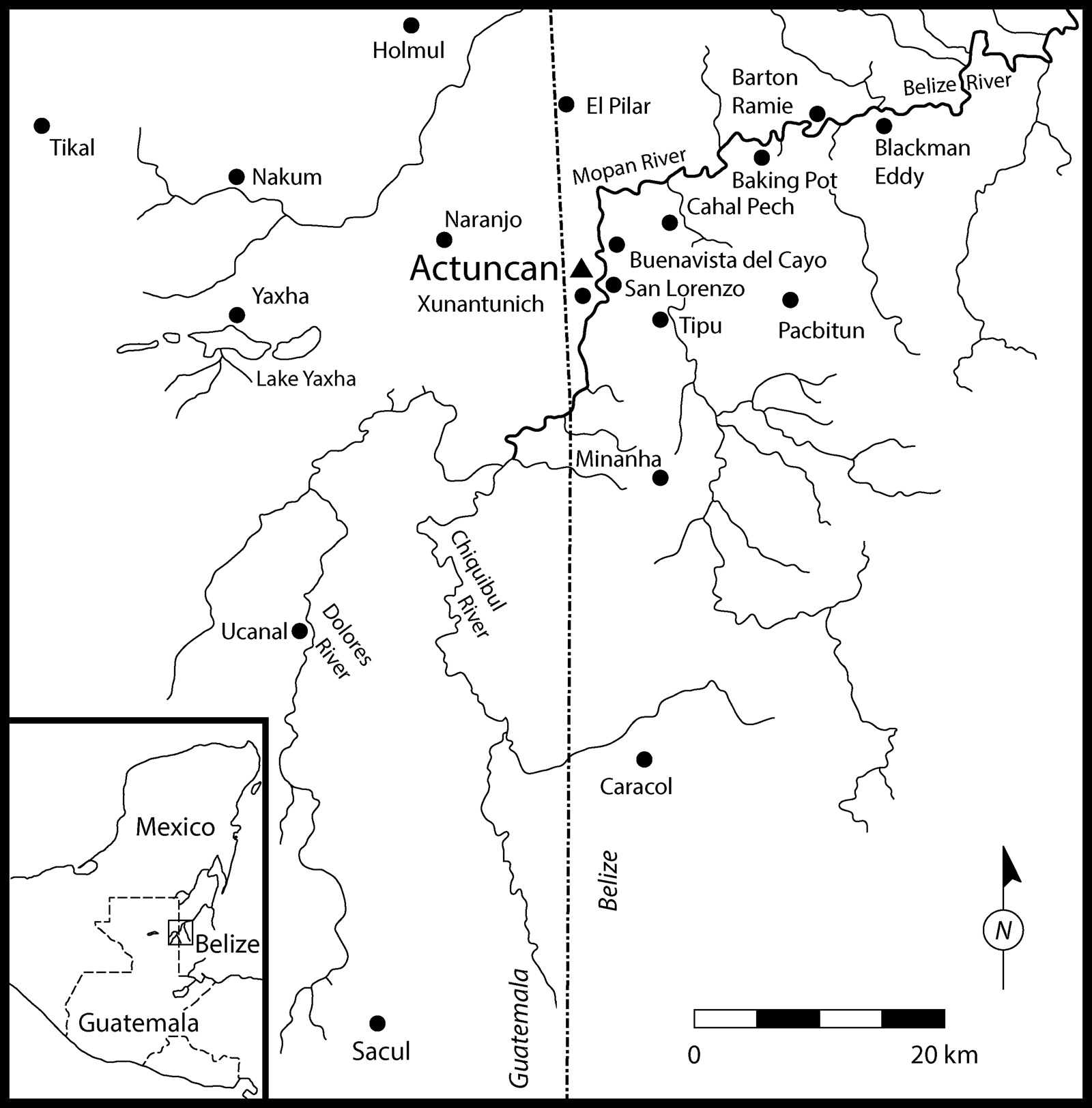
Located on a ridge along the western bank of the Mopan River in western Belize, Actuncan is situated within an area densely populated (Neff Reference Neff, LeCount and Yaeger2010) during the Classic period (Fig. 1). The site is best known for an early carved stela (Fahsen & Grube Reference Fahsen, Grube, Fields and Reents-Budet2005, fig. 4) and monumental architecture constructed largely during the Late and Terminal Preclassic periods (150 bc–ad 250) with renovations continuing into the Early Classic period (ad 250–600). Despite a low number of habitations within Actuncan's centre, it was built into the largest monumental centre in the region during the Late and Terminal Preclassic periods when it consisted of five public plazas bounded by monumental platforms and pyramids up to 27 m tall (see McGovern Reference McGovern2004 for volumetric analysis). Despite a low density of domiciles, Actuncan fits a functional definition of an urban centre, which must have drawn on growing hinterland populations as labour to build its monumental architecture and to fill its plazas and causeways. Further, these constructions represent the ability of early divine rulers to persuade or coerce valley-wide populations to provide labour in support of early public works.
Location of Actuncan within the Mopan River Valley. (After LeCount Reference LeCount2004, fig. 1.)

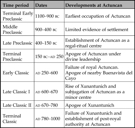
This apogee represents only one phase of Actuncan's 2000-year occupation, from the initial settlement of the ridge top by 1000 bc to the site's final abandonment by ad 1000 (Table 1). Research at the site by James McGovern (Reference McGovern2004) from 1993 to 1995 and since 2001 by the Actuncan Archaeological Project has revealed a dynamic history of occupation marked by periods of rapid growth and impoverishment. Within the lower Mopan River valley, power shifted between several ceremonial centres in sequence (LeCount & Yaeger Reference LeCount, Yaeger, LeCount and Yaeger2010; Leventhal & Ashmore Reference Leventhal, Ashmore and Garber2004). After Actuncan served as an early royal seat, authority was diverted to the nearby centres of Buenavista del Cayo and Xunantunich during the Early Classic and Late Classic (ad 600–780) periods, respectively. Excavations have revealed only limited evidence of Late Classic-period monumental construction or ritual activity within Actuncan's public spaces. However, Actuncan was not abandoned in the Early Classic period. Excavations on house mounds within the Actuncan core show that most households continued to be occupied throughout the Classic period (LeCount et al. Reference LeCount, Walker, Blitz and Nelson2019; Mixter et al. Reference Mixter, Fulton, Bussiere and LeCount2014). Rather than a capital, during the Late Classic period, Actuncan likely functioned as a secondary centre within the Buenavista del Cayo and, later, Xunantunich polities (Mixter et al. Reference Mixter, Jamison and LeCount2013). This distinction is important because the continuity of occupation suggests that the Terminal Classic occupants at Actuncan may be descended from the occupants of the site during its earlier apogee and may have passed down memories of that time (Mixter Reference Mixter2017a).
Summary of Actuncan's political chronology.

By the beginning of the Terminal Classic period, defined locally as beginning in ad 780 based on ceramic seriation and radiocarbon dating (LeCount et al. Reference LeCount, Yaeger, Leventhal and Ashmore2002), the authority of divine rulers at Xunantunich had already begun to wane (Ashmore et al. Reference Ashmore, Yaeger, Robin, Demarest, Rice and Rice2004; LeCount et al. Reference LeCount, Yaeger, Leventhal and Ashmore2002). During this time, much of the site's civic complex was abandoned and public activities were restricted to one small plaza in front of the site's largest ceremonial structure (Jamison Reference Jamison, LeCount and Yaeger2010; Yaeger Reference Yaeger, LeCount and Yaeger2010). At the same time, other local centres, such as Buenavista del Cayo and Cahal Pech (Awe Reference Awe2013; Helmke et al. Reference Helmke, Ball, Mitchell and Taschek2008), began to bury individuals in the manner of divine rulers, contesting Xunantunich's claim to wide-reaching regional authority (Yaeger Reference Yaeger2008). Similarly, at Actuncan, the razing and ritual termination of a household interpreted as the Late Classic residence of a noble vassal from Xunantunich would have served as a dramatic declaration of independence (Mixter et al. Reference Mixter, Jamison and LeCount2013). Finally, populations in the upper Belize River valley began to emigrate even before the Terminal Classic period began, indicating a diminution in Xunantunich's ability to call on the labour necessary to support the royal court and maintain that site's infrastructure (Ashmore et al. Reference Ashmore, Yaeger, Robin, Demarest, Rice and Rice2004). Sometime after ad 849, the divine rulers at Xunantunich lost their remaining authority, and the civic core was abandoned (LeCount et al. Reference LeCount, Yaeger, Leventhal and Ashmore2002).
The political collapse of centres in the Mopan River valley happened during a period of gradual demographic decline, but did not inspire a rapid and absolute demographic collapse (Ashmore et al. Reference Ashmore, Yaeger, Robin, Demarest, Rice and Rice2004). Instead, territorial control over the landscape fragmented as individual communities took responsibility for developing their own localized systems of governance. Data from the Mopan River valley and nearby Vaca Plateau also indicate that the hardships of the Terminal Classic period resulted in societal compression (following Iannone et al. Reference Iannone, Chase, Chase and Iannone2014, 293–4) whereby non-royal households with the oldest claim to local land and resources formed the core of the remaining population (Ashmore et al. Reference Ashmore, Yaeger, Robin, Demarest, Rice and Rice2004; Lamoureux-St-Hilaire et al. Reference Lamoureux-St-Hilaire, Macrae, McCane, Parker and Iannone2015; Robin Reference Robin2013, 168–73). Ruling families likely fled (or died) and poor populations chose to leave. Like the longest occupied households in the surrounding hinterlands, the households at Actuncan were deeply rooted, and their members chose to remain at the site through the Terminal Classic period (Fulton Reference Fulton2019; LeCount et al. Reference LeCount, Walker, Blitz and Nelson2019; Mixter et al. Reference Mixter, Fulton, Bussiere and LeCount2014). As Xunantunich's power contracted, Actuncan initiated a renewed programme of civic construction and ritual activity and the site's long-lived households formed the core of a new, more inclusive socio-political order that was no longer led by divine rulers (LeCount et al. Reference LeCount, Keller and Blitz2011; Mixter Reference Mixter2016).
In the section that follows, I present information detailing the Preclassic layout of Actuncan's site core and its subsequent reorganization following the Terminal Classic period end of divine rulership. These findings shed light on the decision-making of Actuncan's community leaders during the Terminal Classic reconstruction of sociopolitical institutions.
Removing the divine from rule—Actuncan's changing site plan
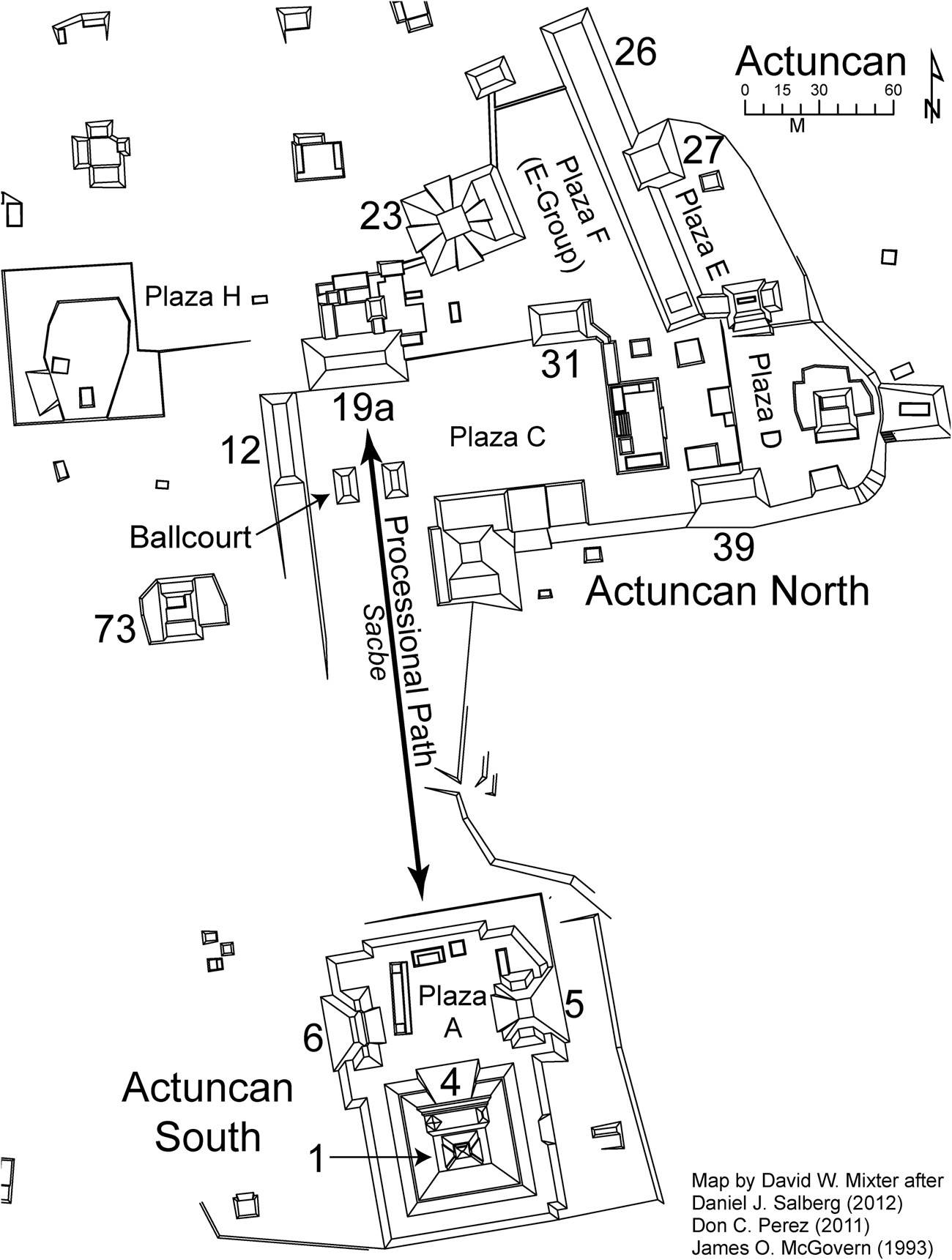
Actuncan's public architecture is organized into two formal civic-ceremonial groups located on adjoining hilltops (Fig. 2). Actuncan South, the site's ritual centre, housed a visually dominant triadic pyramid group, the Late Preclassic carved stone monument and several uncarved monuments. Actuncan South is isolated from the much larger Actuncan North by a ravine. The site's only known formal causeway, or sacbe, skirts the western edge of the ravine connecting the two parts of the site. In contrast to Actuncan South's single plaza, Actuncan North is organized into five public plazas bounded by monumental structures that likely served a variety of ceremonial, administrative, economic and residential purposes. The arrangement of Actuncan's monumental architecture was likely designed in service to the needs of the site's early rulers, who aimed to secure their roles as leaders through both practical and ideological means.
Map of Actuncan. Structures mentioned in the text are labelled with their structure number. Note the route of the processional path linking Actuncan North and Actuncan South.

Starting in the Late Preclassic period, the Actuncan urban centre was constructed following the specifications dictated by the site's earliest rulers. Evidence from deep excavations in Actuncan North indicate that the site's monumental centre was constructed in a single effort that buried a pre-existing Late Preclassic village. As seen in similar events at other sites (Freidel Reference Freidel, Robertson and Freidel1986; Hammond & Gerhardt Reference Hammond and Gerhardt1990; Powis et al. Reference Powis, Healy and Hohmann2009), this kind of wholesale village burial reflects a momentous local reconceptualization of the role of urban architecture that accompanied the local adoption of royal rule. Suddenly, towns shifted from organic aggregations of domiciles to explicitly planned civic cores that emphasized monumentality and public space (Hansen Reference Hansen and Grube2012). This shift reflects a sudden change in political organization in which community leaders likely consolidated sufficient authority to gather the labour needed for the construction of monumental planned architecture. Further, the large-scale dismantling and burial of the earlier village under new public architecture indicates that this transition came with the agreement or coercion of pre-existing community members, many of whom would have been displaced. This moment of construction provided Actuncan's nascent rulers with the opportunity to shape the site's urban layout to the specific needs of Maya divine rulership.
Representing divine rule in Actuncan's Preclassic site design
Actuncan's site plan was established during the Late and Terminal Preclassic periods. Renovations during the Early Classic period added height and volume but did not significantly modify the layout of the site. As Actuncan's early rulers attempted to consolidate power, they adopted conventions already in use across the Maya heartland to build the site centre. Although the arrangement of structures was likely determined in part by the preexisting topography, Actuncan's architecture includes many constituent parts common during the Late Preclassic period, including a triadic temple group, a large E-Group complex and a ball-court (Doyle Reference Doyle2017; Estrada-Belli Reference Estrada-Belli2011; Hansen Reference Hansen and Houston1998). Range structures, long multi-roomed buildings, framed the plazas of Actuncan north. These structures defined the site's six public plazas, which, along with the single broad causeway, likely played critical roles as spaces for day-to-day interaction, administration and periodic community celebrations.
The construction and arrangement of Actuncan's architecture served to support the ruler's power in at least three ways. First, the urban core provided a setting for the everyday administration of the polity (Inomata Reference Inomata, Inomata and Houston2001, 29–32). Second, the site's temples and associated plazas served as important ritual performance venues where leaders could act out the cosmological underpinnings of their rule (Inomata Reference Inomata2006; Schele & Freidel Reference Schele and Freidel1990, 96–129). Third, these buildings and the broader site plan evoked cosmological principles that emphasized the ruler's place as interlocutor between the population and the supernatural (Ashmore Reference Ashmore, Hanks and Rice1989; Reference Ashmore1991). Together, these functions played a critical role in integrating the sacred and managerial roles of Maya rulers by metaphorically connecting spaces associated with periodic ritual and daily administration into a coherent whole.
Actuncan South's large triadic temple group anchors the site's tallest ritual architecture around Plaza A. Structure 1 is the tallest pyramid in Actuncan's site core, rising 27 m above the plaza surface. Actuncan South consists of two nested triadic arrangements of temples forming a ‘fractal-type’ triadic group (Szymański Reference Szymański2014). Three small pyramids, including the vaulted Structure 1, are located on top of the monumental pyramidal platform, Structure 4. The second triadic arrangement is centred on Structure 4, which is flanked by Structures 5 and 6 on the east and west sides of Plaza A.
Within Preclassic Maya centres, triadic temple groups likely served as community gathering locations for ritual ceremonies that promoted the divine authority of rulers. The elevated platform of Structure 4 provided a stage from which the king or queen could perform and a restricted space for gathering elite in private ceremonies (cf. El Tajín: Reese-Taylor & Koontz Reference Reese-Taylor, Koontz, Koontz, Reese-Taylor and Headrick2001). These events took place in a space rich in cosmological references. Structures 4 and 5 were adorned with monumental stucco masks (McGovern Reference McGovern2004), which would have placed events within the triadic group in a vivid supernatural context. Though the mask programs of different triadic groups vary, they often represent themes that can be related to Maya myths of creation and rebirth (Szymański Reference Szymański2014). Furthermore, the triadic arrangement of structures has been viewed as a metaphor for the place of creation or the place of the Maize God’s resurrection (Freidel et al. Reference Freidel, Schele and Parker1993, 140; Hansen Reference Hansen and Houston1998, 80; Szymański Reference Szymański2014). As such, the triadic group symbolized the ruler’s divine power by placing performances within a sacred space filled with cosmological references (Freidel & Schele Reference Freidel and Schele1988).
While Actuncan South functioned as sacred space with predominantly periodic use, Actuncan North served as the primary setting for everyday public life at Actuncan. This portion of the site contained intertwined spaces dedicated to sacred and mundane activities. Aside from Actuncan South, the most important sacred space at Actuncan is the E-Group complex situated around Plaza F (Donohue Reference Donohue and LeCount2014; LeCount et al. Reference LeCount, Mixter, Simova and LeCount2017; Simova Reference Simova, Mixter and LeCount2018; Reference Simova, Mixter and LeCount2019; Simova & Mixter Reference Simova, Mixter, LeCount and Mixter2016). E-groups are nearly ubiquitous within Late Preclassic centres and were critical to early community life and for establishing territorial claims (Chase & Chase Reference Chase, Chase and Grube1995; Doyle Reference Doyle2012; Freidel et al. Reference Freidel, Chase, Dowd and Murdock2017). Consistent with the typical arrangement of E-Groups, Plaza F is bounded on the east by a long linear platform and on the west by a tall radial pyramid. Although studies indicate most E-Groups were not aligned as functioning solar observatories, they were quite standardized in form and size and likely served as metaphorical referents to the passing seasons (Aimers & Rice Reference Aimers and Rice2006; Aveni & Hartung Reference Aveni, Hartung and Aveni1989). Additionally, E-Group plazas may have functioned as important early venues for periodic gatherings and, perhaps, economic activities (Doyle Reference Doyle2012; Simova et al. Reference Simova, Wells, Mixter and LeCount2018; Stanton & Freidel Reference Stanton and Freidel2003). Recent research indicates that E-Groups are the earliest form of Preclassic Maya monumentality (Inomata et al. Reference Inomata, Triadan, Aoyama, Castillo and Yonenobu2013) and were often replaced or superseded by triadic temple groups by the end of the Late Preclassic period, perhaps reflecting the increased verticality of Maya hierarchies (Hansen Reference Hansen and Houston1998; Saturno et al. Reference Saturno, Rossi, Beltrán, Brown and Bey2018).
Aside from the E-Group, Actuncan North was composed of facilities dedicated to polity administration and urban residences. Actuncan North features several range structures, including Structures 12, 19a, 31, and 39, which likely served as venues for a variety of functions related to polity administration. Research on range structures from across the Maya Lowlands indicates that activities in these spaces include audiences and meetings hosted by rulers and elite administrators, the storage of tribute and ritual regalia and the production of specialized elite crafts (Inomata & Triadan Reference Inomata and Triadan2000; LeCount et al. Reference LeCount, Wells, Jamison and Mixter2016; Reents-Budet Reference Reents-Budet, Inomata and Houston2001; Terry et al. Reference Terry, Fernández, Parnell and Inomata2004). Although occasionally implicated in preparations for rituals, these spaces were most commonly dedicated to the political and managerial roles of rulers and their supporting bureaucracy, reflecting the practical rather than divine role of Maya rulers.
In contrast to the ritual specificity of Actuncan South, Actuncan North is an integrative space that through its design likely facilitated the mundane interactions required for the daily construction of community and the operation of the state while also providing performance venues for periodic events. Individuals living in the urban elite and commoner residences surrounding Actuncan North likely would have interacted with each other and the government apparatus as they went about their daily lives within the large public plazas and administrative buildings. These individuals would have developed community-level social and economic relationships through encounters and conversations while transiting the urban core (Low Reference Low2000). Additionally, community members would periodically have interacted with royal administrators, for example during negotiations over access to public goods (LeCount et al. Reference LeCount, Walker, Blitz and Nelson2019). As a whole, Actuncan North functions as the city's economic, civic and social hub and highlights the role the ruler as head of state plays in facilitating these interactions.
For the ancient Maya, holy lords’ power was based in their role in facilitating daily life and ensuring the continuation of that life through appeals to the supernatural (Freidel Reference Freidel and Brisch2008; Houston & Stuart Reference Houston and Stuart1996; Iannone et al. Reference Iannone, Houk and Schwake2016). This integration would have been strongly manifest in ritual processions connecting the cosmologically charged Actuncan South to Actuncan North—the hub of everyday life (see Figure 2). These spaces were coupled by a broad formal causeway or sacbe. Previous research into the uses of Maya causeways has drawn on ethnographic sources, ancient Maya site plans and ancient Maya depictions to show that these roads were used for ritual processions as well as daily access (Keller Reference Keller2006; Reese-Taylor Reference Reese-Taylor and Stone2002). The sacbe at Actuncan places Structure 19a, the site's tallest range structure, in opposition with the broad staircase that forms the formal entrance to Actuncan South's Plaza. Royal processions likely would have first passed from Structure 19a—likely the symbolic administrative centre of Actuncan—through the ball-court located at the northern end of the sacbe. Ball-courts are often interpreted as portals (Schele & Freidel Reference Schele, Freidel, Scarborough and Wilcox1991). In this case, the ruler and his entourage could be understood as passing from the world of humans to the supernatural place of creation located at Actuncan's triadic temple group. The royal procession down the sacbe from the human world through the portal into the supernatural world may have materialized the connection between the ruler's civic duties as head of state—represented by Structure 19a—and his roles as divine interlocutor—represented at Actuncan South.
Separating divine from rule
When the local community abandoned the rule of divine leaders during the Terminal Classic period, they were tasked with reconstructing their political institutions to ensure continued order in community interactions. Because the collapse included the end of divine kingship, the resilience of the community depended on members’ ability to rework the articulation of new authority structures with their cosmology. At Actuncan, the community appears to have decided to symbolically separate political and religious institutions by physically isolating the spaces dedicated to each of these spheres of life.
The several-century gap in Actuncan's use as a centre of authority from the early part of the Early Classic period to the Terminal Classic period resulted in a clear discontinuity in the use of monumental architecture and public space. This gap provides an unusual opportunity to look at how a Terminal Classic community repurposed an earlier centre during the post-collapse period. The major exception is Structure 19a, Actuncan's largest range structure. During the Late Classic, this Preclassic building was converted into an elite residence, which likely served as the palace of a secondary elite who ruled Actuncan under the auspices of a Xunantunich king or queen (Mixter et al. Reference Mixter, Jamison and LeCount2013). Contemporaneously, limited renovations took place on the ball-court, along the sacbe and within the triadic temple group (McGovern Reference McGovern2004). These renovations appear to have reified the major processional route established during the Preclassic period. However, these activities presumably took place under the aegis of Xunantunich and were likely intended to emphasize the power of the noble vassal inhabiting Group 8, perhaps as part of an effort to strengthen Xunantunich's claim over Actuncan's earlier history (Ashmore Reference Ashmore, Ciudad Ruiz, Fernándex Marquínez, García Campillo, Iglesias Ponce de León, García-Gallo and Sanz Casto1998; Mixter Reference Mixter2017a).
In contrast, excavations into other Preclassic ritual and civic architecture indicate that these locations were only used in a limited manner during the Late Classic period (McGovern Reference McGovern2004; Mixter Reference Mixter2016). Furthermore, the site's public plazas do not appear to have been maintained after the Early Classic period (Mixter Reference Mixter, LeCount and Keller2011, 52). The lack of investment in public architecture during the second half of the Early Classic period likely reflects the move away from local rule, while the select reoccupation of ritual and administrative spaces during the Late Classic period reflects the site's utilization as a secondary centre during Xunantunich's apogee. Importantly, many of the site's urban residences remained occupied continuously, and their inhabitants witnessed Actuncan's fluctuating role in the local political geography (Mixter Reference Mixter2017a; Mixter et al. Reference Mixter, Fulton, Bussiere and LeCount2014).
During the Terminal Classic period, the local community systematically reengineered Actuncan's site plan by constructing a new monumental political centre and selectively revering, renovating and actively dismantling public architecture remaining from the era of royal rule. This reorganization effectively divided the centre into two disconnected parts, a political centre focused on Actuncan North and a ritual centre in Actuncan South. While the original site plan spatially integrated Actuncan's political and ritual functions through the sacbe and shared space, Terminal Classic patterns of architectural use disconnected the major centres of political and ritual life and instead created separate political and ritual realms that better fitted post-royal rule.
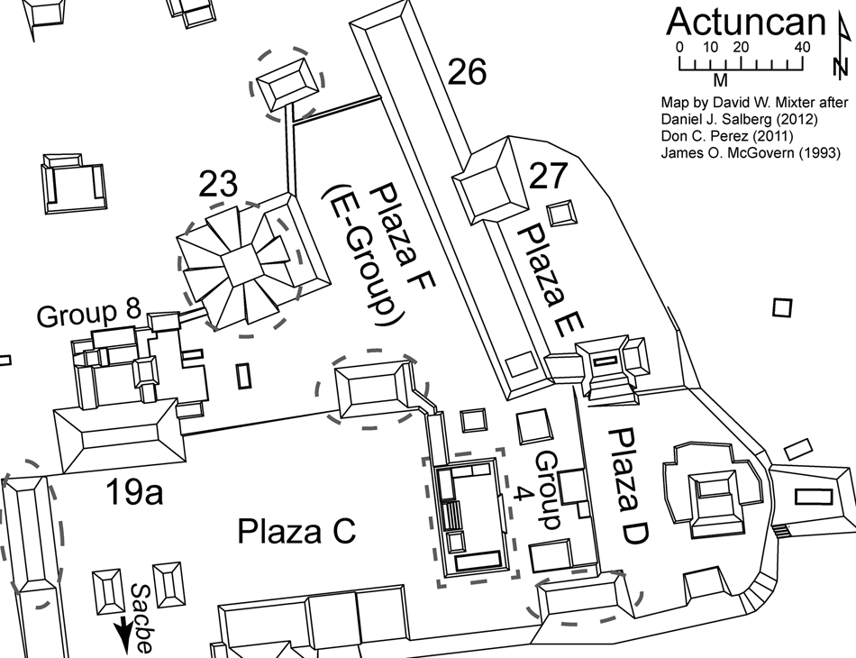
Monumental construction efforts during the Terminal Classic period focused primarily on the construction of Group 4, a complex of structures located at the west end of Plaza D (Fig. 3). The largest effort focused on the construction of a large (approximately 35×20 m) basal platform with an average height of 1.5 m above Plaza D. This construction was the largest labour investment marshalled by the Terminal Classic community, indicating its centrality to the organization of the post-collapse community. The platform supported approximately six buildings along the north, west, and southern perimeters of the platform. These structures likely housed the administrative and political functions previously located in range structures during the Preclassic and Classic periods. Additionally, the broad patio space constructed between these structures may have served as a venue for community gatherings and as a stage for performances directed at an audience located in Plaza D. In contrast to the exclusive nature of Classic period polity business that took place inside the small interior spaces of elevated range structures, Group 4 is an open, accessible space that would have housed a more inclusive political organization in the post-royal period (Mixter Reference Mixter2016; Reference Mixter2017b).
Map of Actuncan North highlighting the locations of Late and Terminal Classic alterations to the site core. The dashed grey ellipses circumscribe unexcavated structures that appear to have been intentionally dismantled. The dashed rectangle highlights the broad platform constructed as a base for Group 4 during the Terminal Classic period.

One notable aspect of Group 4's construction is its location within the heart of Actuncan North on top of a razed building that originally separated Plazas C and D (Mendelsohn & Keller Reference Mendelsohn, Keller, LeCount and Keller2011). Despite the existing public infrastructure within the site core, the community did not reuse the site's range structures or E-Group during the Terminal Classic period. Initially constructed as part of the integrated site plan aimed at supporting the institution of divine kingship, these spaces were no longer appealing to the site's residents. Instead, these buildings were dismantled.
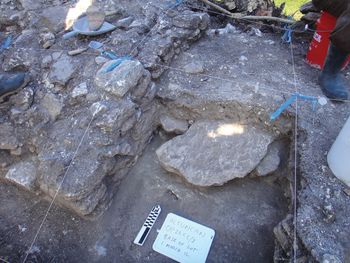
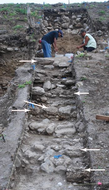
Prior to the Terminal Classic period, Structure 19a served two previous roles in the Actuncan community, first as the site's largest Preclassic and Early Classic range structure and then as the focal point of a Late Classic ruler's residence. During the Terminal Classic period, this structure's vaulted roof and masonry walls were removed and the interior rooms filled and sealed, effectively terminating the use life of this structure (Mixter et al. Reference Mixter, Jamison and LeCount2013, 95–7). The structure's vault stones were specifically selected for incorporation into the filling process (Fig. 4). Similarly dramatic acts of filling or burying palace structures at other Maya sites have been associated with transitions in leadership or the termination of royal rule (Iannone Reference Iannone2005; Laporte Reference Laporte1989; Yaeger Reference Yaeger, LeCount and Yaeger2010). Excavations at the base of the structure uncovered only a small amount of collapse debris, indicating that the stones from the deconstructed superstructure were carefully removed, not simply hurled off the platform (Jamison Reference Jamison and LeCount2013, 21–3). Additionally, many of the blocks that composed the staircase used to access the summit of Structure 19a appear to have been removed in antiquity. Figure 5 is a photograph showing the terminal version of the staircase during excavation. Most of the steps were defined based on in situ river cobbles that backed the staircase's cut limestone block risers in the original construction. A few remaining cut limestone blocks illustrate the original engineering of the staircase. The general lack of in situ cut stones and the absence of substantial collapse debris indicate that the missing stones did not fall but were intentionally removed. This act would have rendered the summit of Structure 19a unreachable by any formal route.
A large vault stone buried in a door of Structure 19a's superstructure. (Photograph: Thomas R. Jamison.)

The terminal staircase of Structure 19a as found in excavations is seen in the foreground. The few original cut limestone blocks that formed the original stair risers were found in situ, as annotated by arrows in the photograph. All other stones are river cobble stones from the structure fill. We largely defined the staircase based on irregularly shaped river cobbles that backed the cut stone facings. Importantly, many cut stones, but not the river cobble backing, were removed. The few remaining cut stones speak to the staircase's original engineering and the unsystematic way in which the stones were removed. (Photograph: Lisa J. LeCount.)

Despite the E-Group's cosmological importance during the Preclassic period, it does not appear to have been used during the Terminal Classic period. Instead, our excavations indicate that both Structure 26, the linear eastern platform, and Structure 23, the western pyramid, were dismantled in a manner similar to Structure 19a. The Terminal Classic Maya removed most of the cut stones from Structure 26's staircase, leaving the fill below in place (Donohue Reference Donohue and LeCount2014). Yet the fact that a few stones were left in place indicates that this dismantling happened somewhat casually rather than as a concerted effort to destroy the staircase. Additionally, the complete absence of fallen cut stones at the foot of the stairs indicates that natural processes did not lead to the dismantling of Structure 26. Excavations on the eastern side of Structure 23 also found few facing stones (Heindel Reference Heindel, LeCount and Mixter2016). Only the rubble core remained of the final construction phase, indicating that the building's façade was dismantled in antiquity.
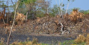
The removal of cut stones from Structures 19a, 23, and 26 fits a pattern of destruction that appears to extend to much of Actuncan North's monumental architecture. Most of Actuncan North's unexcavated public structures are visually remarkable because they appear to be piles of large river stones rather than nicely formed Maya platforms (i.e. Structure 12, as seen in Figure 6). Like the excavated examples, these buildings likely featured cut stone façades that fronted large stone fill. During excavations we did not encounter enough cut limestone blocks in collapse contexts to account for those missing from the façades of these buildings. At the same time, excavations into the Group 4 platform indicate that the Actuncan Maya largely used cut stones to fill this large substructure. The use of attractive dressed stone as fill contrasts with the rough-hewn limestone or unhewn river cobbles used in the core of the site's Preclassic constructions. The local community had little reason to maintain the monumental architecture associated with the administration of the previous regime. Instead, after ritually closing some spaces, these buildings were systematically mined for stone. Practically speaking, these buildings provided the most readily accessible source of construction material. More importantly, the act shows a clear disregard for the remnants of royal authority at the site. The community chose to build a new political centre and intentionally disassemble the old surrounding infrastructure, patterns that point to the community's break with earlier structures of authority.
Structure 12 at Actuncan, showing the river cobble core fill emerging from the structure's modern surface. Excavations on Structure 19a (see Figure 5) and 23 (Heindel Reference Heindel, LeCount and Mixter2016; Jamison Reference Jamison and LeCount2013), which also appeared to be cobble-covered prior to excavation, indicate that the cobble-covered appearance of many mounds in Actuncan North resulted from the removal of the cut limestone façades in antiquity rather than natural processes of collapse. The absence of fallen cut stones at the bases of these buildings and the presence of a few remnant limestone blocks in situ speak to the intentional act of removal.

These Terminal Classic actions also destroyed the integration of the political and ritual spheres built into the original site layout. Previously, Actuncan North interdigitated ritual and civic spaces; however, during the Terminal Classic period, these functions became segregated. Actuncan's E-group was dismantled and the largest range structure was capped and dismantled. The destruction on Structure 19a also eliminated one terminus of the processional path connecting Actuncan North to Actuncan South, breaking the metaphorical connection between the site's political and religious centres. Instead, Group 4 replaced the administrative and civic gathering functions previously located in Structure 19a (Mixter Reference Mixter2017b). Group 4 was built facing away from Plaza C and the sacbe and was not connected to Actuncan South by any direct path. This organizational shift physically divided Actuncan into two separate and unconnected realms. Abandoned and partially dismantled buildings in the centre of the city formed a buffer between Group 4 and the remaining religious space located in Actuncan South. The result was a reorganized urban core in which historic venues of royal authority were no longer spatially connected to the Terminal Classic political process.
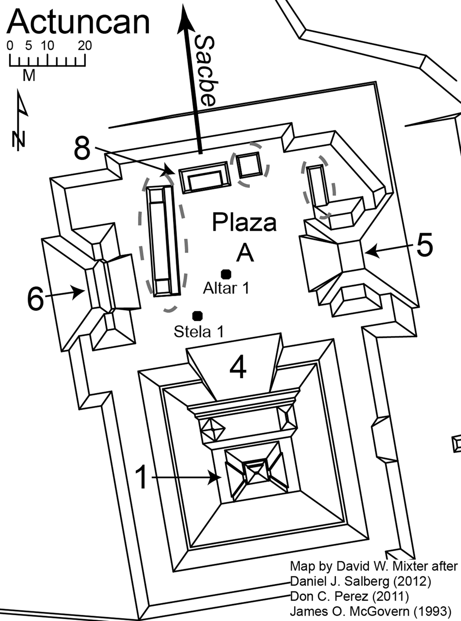
Despite these changes, one old ritual space at Actuncan did not go out of use. The triadic temple group at Actuncan South was the location of new construction and renewed ritual activity (Fig. 7). During his work recording a large looter's trench into Structure 5, McGovern (Reference McGovern2004) identified an 80 cm thick deposit of burned ceramic materials. The size and density of this deposit indicates an accumulation of materials over time, reflecting repeated reverential ritual. Additionally, four low Terminal Classic platforms were constructed in Plaza A to facilitate this ritual action (Mixter Reference Mixter2016, 263–89). The most important of these is Structure 8, a low platform that would have supported a perishable building. Structure 8 was constructed across the main entrance to Plaza A, dividing this space from the sacbe to the north. This building had three or five narrow doors that community members would have had to pass through to access Plaza A. Structure 8 would have impeded processions along the sacbe, effectively isolating Plaza A from the remainder of this site core. This allowed Actuncan South to remain a place for ritual appeals to supernatural forces and ancestors, without implying a connection between these forces and the community's ruling institutions.
Map of Actuncan South highlighting the Terminal Classic uses of this space. In addition to Structure 8, the three structures circumscribed by dashed ellipses were constructed during the Terminal Classic period. Note how Structure 8 would have blocked the central access from Plaza A to the sacbe, interrupting the previously unimpeded processional path.

While the original Late Preclassic formulation of Actuncan's site layout emphasized the role of the ruler as a divine interlocutor presiding over the daily political and economic activities of the state and its constituents, the modified landscape explicitly breaks these bonds. When only the buildings in active use are considered, Actuncan's Terminal Classic landscape was clearly divided between a southern ritual group and a northern political space. The destruction of Structure 19a and construction of a low entry building blocking access to Plaza A destroyed the processional path and created separation between the triadic group and the northern civic zone. Additionally, much of the old royal infrastructure in the site's northern sector was terminated and dismantled. In this way, the Actuncan Maya pulled apart the monumental trappings of divine leadership in Actuncan North, rendering them unusable and their associations defunct.
Discussion
In the moments immediately after a political failure, a community's resilience is dependent on its ability to successfully renegotiate the rules of social relations between those who remain in place. For the Maya, this process was complicated by the fraught disentanglement of the justification for leadership from cosmological principles. In areas where new principles of leadership could not be agreed upon, population numbers declined and centres were quickly abandoned. The Actuncan community's strategies for managing the dissolution of divine kingship represent one of a mosaic of variably successful options adopted by Terminal Classic period communities (Demarest et al. Reference Demarest, Rice and Rice2004; Iannone et al. Reference Iannone, Houk and Schwake2016). While some supported rejuvenated royal lineages freed from the bonds of failing Classic period hegemons (Inomata & Triadan Reference Inomata, Triadan, Arnauld and Breton2013; Źrałka & Hermes Reference Źrałka and Hermes2012), other centres built new institutions anchored in cultural connections to the more stable northern Maya Lowlands (Harrison-Buck Reference Harrison-Buck2007; Masson & Mock Reference Masson, Mock, Demarest, Rice and Rice2004; McAnany Reference McAnany2012). Like Actuncan, other centres likely followed more innovative paths heavily impacted by local historical contingencies (Lamoureux-St-Hilaire et al. Reference Lamoureux-St-Hilaire, Macrae, McCane, Parker and Iannone2015; Mixter Reference Mixter2017a; Schwarz Reference Schwarz2009). Importantly, reorganization strategies were successful when communities bought in to new institutions and remained intact. When communities atomized, people emigrated.
In all cases, the establishment of new political institutions resulted in substantial modifications to the built landscape as communities reconsidered authority structures and their relationship to cosmological principles. Despite ongoing innovation, communities that remained in the southern Maya Lowlands were surrounded by the remains of the Classic period cities, which served as constant reminders of the past. Even where new capitals were established away from historical centres, the physical size of Maya pyramids ensures they would have remained present in the local consciousness. In fact, many abandoned Preclassic and Classic period centres became pilgrimage destinations (Andres & Pyburn Reference Andres, Pyburn, Demarest, Rice and Rice2004; Brown Reference Brown2011; Hansen et al. Reference Hansen, Howell, Guenter, Stanton and Magnoni2008; Robin et al. Reference Robin, Meierhoff, Kestle, Blackmore, Kosakowsky, Novotny and Robin2012). Where populations dwelled amongst the monumental ruins, they continued to interact with the past on a daily basis (Halperin Reference Halperin2014; Lamoureux-St-Hilaire et al. Reference Lamoureux-St-Hilaire, Macrae, McCane, Parker and Iannone2015; Mixter Reference Mixter2017a; Navarro-Farr Reference Navarro-Farr, Iannone, Houk and Schwake2016). Perhaps because of their association with transcendent cosmological concepts, triadic pyramid groups in particular remained places of reverence (Halperin Reference Halperin2014). In contrast to the pomp and circumstance of royal performance during the Classic period, the Terminal Classic ritual activities taking place within these spaces were modest and may have represented individuals or household groups placing offerings. This kind of practice, as seen at Actuncan's Structure 5, points to direct contact between individuals and the supernatural in monumental space, without royal intercession.
For the residents of Actuncan, the ninth-century ad failure of divine leadership led to a series of institutional reforms evident in the built landscape. In contrast to the many lowland communities that failed in their reorganization attempts, the Maya of the Mopan River valley adopted a series of strategies that proved to be successful. The centrepiece of this strategy was the establishment of a new capital within the old Actuncan site core. Because of the placement of the new site within the remains of an old royal capital, the community was forced to decide how to treat the tangible architectural remains of divine kingship (Halperin Reference Halperin2014; Stanton & Magnoni Reference Stanton and Magnoni2008). Rather than constructing a new capital, Actuncan's new leaders managed this dilemma by functionally separating the venues for cosmological rituals and political life. The Classic period site plan had served to integrate the different parts of the site by facilitating movement and building cosmological metaphors. These connecting principles were dissolved in the Terminal Classic as the active political and ritual spaces were circumscribed and spatially separated. Furthermore, the post-collapse community largely ignored the architectural infrastructure of divine rulers. Instead, the dismantled administrative and ritual buildings in Actuncan North were used as fill for the construction of their new political centre.
As a kind of urban planning, the reorganization of public spaces provides an opportunity to embed powerful political messages expressed explicitly through shared symbols and ceremonies and implicitly by forcing changes to the daily practices of those inhabiting the site centre. I interpret the reorganization of Actuncan's urban landscape during the Terminal Classic as evidence for an explicit local rejection of the logic that underpinned Classic period divine kingship. This logic was abandoned across the Maya Lowlands around this time (Iannone et al. Reference Iannone, Houk and Schwake2016), but it is likely that the processes by which divine kingship was rejected varied regionally. By destroying the Preclassic political and administrative buildings, new leaders indicated a distancing from both past rulers and the exclusive and hidden spaces they used to conduct the business of governance. Furthermore, the severing of the processional path between Actuncan North and Actuncan South suggests that the new form of leadership was no longer reliant on the deep connection between leadership and the supernatural evident in the Classic period. Actuncan's previous public architecture was replaced by Group 4, a new civic space laid out according to more accessible, open architectural principles that points to a more inclusive political process.
Elsewhere, I have argued that Group 4 functioned in part as a council house (Mixter Reference Mixter2016). During the Terminal Classic and Postclassic periods in Yucatan, council houses are symbols of more inclusive, secular rule lead by the heads of powerful lineages who met in council (Bey et al. Reference Bey, Hanson and Ringle1997; Bey & May Ciau Reference Bey, May Ciau and Braswell2014; Fash et al. Reference Fash, Fash, Lane, Larios, Schele, Stomper and Stuart1992; Proskouriakoff Reference Proskouriakoff and Pollock1962; Pugh et al. Reference Pugh, Rice, Cecil, Rice and Rice2009). While it is often true that individual lineage heads held primacy for a period of time, the maintenance of their realms was dependent on the continued support of their peers who controlled the affiliation of outlying towns and provinces (Marcus Reference Marcus, Sabloff and Henderson1993; Ringle & Bey Reference Ringle, Bey, Inomata and Houston2001). The ability of these towns and provinces to change affiliation provided powerful backing for a council's influence against aspiring tyrants (Okoshi-Harada Reference Okoshi-Harada, Arnauld, Manzanilla and Smith2012). As such, when the Maya employed councils, authority was likely more dispersed, placing all household leaders on a more equal footing.
Societal compression may have provided an additional motivation to move from Classic period hierarchies towards council-based rule. Emigration of the Mopan River valley's ruling families and the poorest residents indicates that remaining households were on a more even socio-economic level (Ashmore et al. Reference Ashmore, Yaeger, Robin, Demarest, Rice and Rice2004). With the failures of divine kings and queens in recent memory (Iannone et al. Reference Iannone, Houk and Schwake2016), the leaders of these households may have been hesitant to give absolute power to one of their peers. Furthermore, a more shared form of authority would have preserved the new-found socio-economic equality in the valley.
Just as the shifting political organization at Actuncan likely followed the pan-Maya trend towards broader participation in political institutions, the physical separation of the new civic complex from the reconceived ritual space mirrored a broader, pan-Maya trajectory towards a separation between political and religious institutions. As detailed by Masson and colleagues (Reference Masson, Hare, Peraza Lope, Schwartz and Nichols2006, 194–7), during the Postclassic period the process of disentangling the dual roles held by Classic period divine rulers culminated in the establishment of a powerful priesthood separate from the ruling class. This priesthood provided an additional set of checks on the power of the ruling elite. The Postclassic separation of political and religious authority in the hands of lineage heads and priests is attested to in the ethnohistoric literature at Mayapan, Uxmal and in the Petén Lakes (Jones Reference Jones1998, 94; Landa [Reference Landa and Tozzer1566] 1941, 35, n. 173) and is represented in the art of Chichén Itzá (Ringle Reference Ringle2004, 213). This arrangement contrasts strongly with the Classic period, where ritual specialists were likely members of the royal court who took on ritual roles part-time in support of rulers’ intercession with the gods (Houston & Stuart Reference Houston, Stuart, Inomata and Houston2001, 60).
Conclusions
The process of untangling political and religious institutions seen at Actuncan is part of a resilient set of strategies that succeeded across the Maya Lowlands after the Maya collapse. In the long term, political institutions trended towards an organization that restricted the influence of individuals by empowering councils of elites and religious institutions separate from the political establishment. The reorganization of space at Actuncan indicates that the process of reconstruction was conditioned by local contingency. The site's existing Preclassic arrangement forced the post-collapse community to rearrange their space better to fit the new principles underlying their community structure. The urban design strategies adopted by the community were resilient because they backed a form of local leadership that matched the social conditions on hand at the end of the collapse. The success of Actuncan is most evident in its prominence as a post-collapse community for 150–200 years. Well before the site's final abandonment, most of the other major local centres had been abandoned. Locally, Actuncan's success was uncommon. This community's resilient response to the collapse provides a nuanced case study for looking at the strategies successful communities adopted in the face of collapse. These strategies are manifest in the way the local community settled in a centre constructed to emphasize the divine power of kings and queens and modified it to reflect post-collapse values and social realities.
Acknowledgements
A version of this paper was first presented in November 2013 at the 18th European Maya Meetings in Brussels, Belgium. I thank Drs Peter Eeckhout and Sylvie Peperstraete for organizing that symposium. I would like to thank Drs Lisa LeCount, David Freidel and BrieAnna Langlie and two anonymous reviewers for their comments and suggestions, which greatly improved this manuscript. Funding for this research was provided by the Wenner-Gren Foundation (8686), the Washington University Graduate School of Arts and Sciences, and private donors. I am grateful to Dr LeCount and the Actuncan Archaeological Project, supported by the National Science Foundation (BCS0923747) and the National Geographic Society Committee for Exploration and Research (9279–13 and 9658–15), for facilitating my research at Actuncan since 2010. Permission to undertake this research has been granted by the directors and associate directors of the Belize Institute of Archaeology, especially Drs John Morris and Jaime Awe. Thanks to Dr Thomas Jamison, Dr Angela Keller, Dr BrieAnna Langlie, Dr Theresa Heindel, Luke Donohue, Allison Nick, Rebecca Mendelsohn and Borislava Simova who supervised portions of the excavations discussed in this chapter. Thanks to our many local research collaborators form San José Succotz and Benque Viejo del Carmen, Belize, who make our field research possible.