

Introduction
Cupmarks are small circular impressions pecked and ground into the surface of a stone and they are the most widely distributed and numerous rock art motifs within the Nordic Bronze Age rock art tradition (c. 1700–500 bc). In southern Scandinavia alone, more than 27,000 cupmarks have been identified, most of them in Scania (Nimura, Reference Nimura2015: tab. 4.14). Their connection with the Nordic Bronze Age is indisputable, as attested by numerous scenes and imagery depicting aspects of Bronze Age material culture, including ship motifs. Cupmarks are known in isolation, or they can occur together on rock surfaces and free-standing boulders in compositions that are not immediately decipherable (Glob, Reference Glob1969: 109–29; Horn, Reference Horn2015; Milstreu & Dodd, Reference Milstreu and Dodd2018). In such cases, the cupmarks cannot be dated, although they are traditionally thought to belong to the Bronze Age.
The difficulty of dating cupmarks and establishing their cultural context is not limited to Nordic rock art; the subject has also been much debated in the British Isles, where the traditional view is also that they date to the Bronze Age. However, a growing number of scholars recognize that the practice may have started in the Neolithic (Waddington, Reference Waddington1998; Cochrane et al., Reference Cochrane, Jones, Sognnes, Fowler, Harding and Hofmann2015: 879–81; Thomas, Reference Thomas2016: 15).
In Scandinavia, cupmarks are found on megalithic tombs of the fourth millennium bc; the earliest securely dated southern Scandinavian cupmarks were recovered during excavation in 1955 at the Rævehøj burial mound in Gladsaxe north of Copenhagen, located on two stone slabs that formed part of a stone cist dated to the early Late Neolithic (c. 2350–1950 bc) (Vebæk, Reference Vebæk1980). In his 1969 publication on the rock carvings in Denmark, Peter V. Glob records further Late Neolithic burials associated with cupmarks, but not all are securely dated (Glob, Reference Glob1969: 119–23; see also Strömberg, Reference Strömberg1982: 103–06, with references).
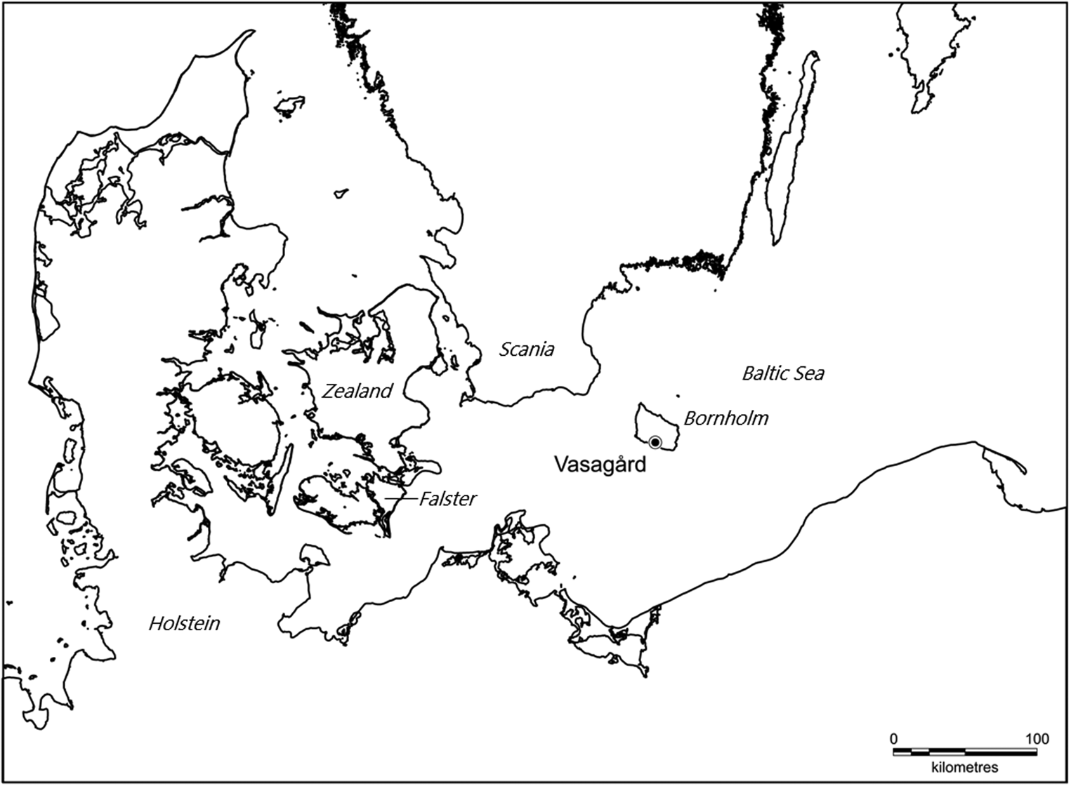
Given the simple design of the cupmarks and their presence on dolmen capstones, one might suspect that cupmarks go back to the Neolithic, as originally suggested by the Danish antiquarian Henry Petersen (Reference Petersen1875: 448–50) in his account of the rock art in Denmark. In this article, we present compelling results from the recent excavations at Vasagård on the island of Bornholm in the Baltic Sea (Figure 1) that clearly indicate that cupmarks were present in the early third millennium bc. This period corresponds to the final phase of the Funnel Beaker northern group, the Middle Neolithic (MN V).
Map of southern Scandinavia showing the location of Vasagård on Bornholm and regions mentioned in the text.

Vasagård on Bornholm
Unlike the rest of Denmark, which is dominated by glacier deposits, Bornholm is essentially a rocky island characterized by exposed bedrock. On the northern two thirds of the island, the Precambrian rock, i.e. granite or gneiss, is only covered by thin Quaternary deposits, if at all. By contrast, the southern, lower-lying part of Bornholm consists of a till plain where the pre-Quaternary sediments are dominated by sandstone, shale, and unconsolidated or poorly consolidated sediments (Frei & Frei, Reference Frei and Frei2013). Even though the Neolithic occupation on Bornholm seems to show a slight preference for the till plain, traces of settlements, hoards, and stray finds have been located over most of the island. Megalithic tombs are predominantly found in the southern part, as are the only two recorded enclosure sites on the island, Rispebjerg and Vasagård (Ebbesen, Reference Ebbesen1985; Nielsen, Reference Nielsen, Fabech and Ringtved1999; Hansen, Reference Hansen, Nielsen, Nielsen and Adamsen2014; Nielsen & Nielsen, Reference Nielsen and Nielsen2020: 72–75, 195–99).
Vasagård lies just south-west of the modern town of Aakirkeby (Figure 1). It is a so-called ‘double enclosure site’ as it consists of two neighbouring and differently oriented causewayed enclosures, Vasagård East and West (Klassen, Reference Klassen2014: 54–55). The two enclosures are separated by the valley of the river Læså, which forms an abrupt vertical river cliff to the west that cuts off the Vasagård West site (Figure 2). There, the river valley expands to a meadow some 100 m wide and up to 10 m below the surrounding terrain. To the east, a steep slope rises up to the hill containing Vasagård East. Both sites consist of semi-circular double circuits of segmented ditches delimited by the river valley. The course of the western circuits is disturbed by the modern farmstead of Vasagård.
LiDAR map of the Vasagård site and immediate surroundings with features mentioned in the text. Archaeological trenches are marked in light grey. The black and dark grey dotted lines indicate the presumed course of the palisades and causewayed enclosure ditches, reconstructed from excavations and geomagnetic surveys. Recorded cupmarked stones are indicated by yellow dots. The Læså river valley separates the Vasagård East and West causewayed and palisaded enclosures.

Finds from the ditches suggest that both causewayed enclosures were established at the transition between the Early and Middle Neolithic, around 3300 bc or after. Most of the early pottery from the ditches dates to MN I (c. 3300–3100 bc), but some sherds indicate occupation in the late Early Neolithic (EN II), in c. 3500–3300 bc (Nielsen & Nielsen, Reference Nielsen and Nielsen2020: 72–74). The stratigraphy and the finds indicate long-term use of the enclosures since the ditches were recut and filled in during the succeeding Middle Neolithic Funnel Beaker phases. Two main recuts were observed: one dated to MN III (around 3000 bc), and one dated to MN V (c. 2900–2800 bc). No further recuts were recorded. Finds from the upper dark fill of the ditches date the deposit to the local Vasagård phase (part of MN V, c. 2900–2800 bc). However, a few sherds in the uppermost layer, and further sherds in a pit cut into the top of one of the ditches, date to the succeeding Grødby phase or early Battle Axe culture period, dated to around 2800–2600 bc (Nielsen et al., Reference Nielsen, Nielsen, Thorsen, Nielsen, Nielsen and Adamsen2014a, Reference Nielsen, Andresen and Thorsen2015; Nielsen & Nielsen, Reference Nielsen and Nielsen2020: 72–75).
Several palisade trenches have been identified during trial excavations, in addition to the double causewayed enclosure at Vasagård. The trenches form part of a Middle Neolithic palisaded enclosure, as known from several other sites in eastern South Scandinavia. While similar contemporary sites have been recorded in Ireland and Britain (Noble & Brophy, Reference Noble and Brophy2011), the Scandinavian palisaded enclosures are only known in Scania and the islands of Zealand, Falster, and Bornholm. Radiocarbon dates range from c. 3000 to 2500 bc (Svensson, Reference Svensson and Gibson2002; Giersing, Reference Giersing2004; Brink, Reference Brink2009; Brinch, Reference Brinch2014). An extensive palisaded enclosure, containing at least fourteen semi-circular palisade trenches and enclosing an area of about six hectares, has been recorded at the contemporary nearby site of Rispebjerg, 8.5 km east of Vasagård. Both enclosures are topographically prominent in the landscape, close to small rivers, and some three kilometres from the present coastline (Svensson, Reference Svensson and Gibson2002: 39–42; Nielsen et al., Reference Nielsen, Nielsen, Thorsen, Nielsen, Nielsen and Adamsen2014a, Reference Nielsen, Nielsen, Thorsen, Nielsen, Nielsen and Adamsen2014b).
In addition to the causewayed and palisaded enclosures, a 34 m-long mound is located just outside the system of segmented ditches, but within the outer palisades, on the Vasagård West site (Figure 2). The mound is significant as it contains two megalithic tombs dated c. 3500–3000 bc, corresponding to the early period in which the ditches were in use. The tombs are defined by a rectangular Early Neolithic dolmen chamber and an early Middle Neolithic passage grave. Ground-penetrating radar surveys, together with limited excavation in 2008, clearly show that both the dolmen chamber and the passage grave each had a round mound encircled by kerbstones (Hansen, Reference Hansen, Nielsen, Nielsen and Adamsen2014: 48–56). Fifteen cupmarks were recorded on the exposed top of the dolmen capstone. In addition to the cupmarks, county governor Emil Vedel noted in 1897 a Bronze Age ship motif on the capstone. It could not be found by Glob in 1969 and is highly likely to be a misconception (Vedel, Reference Vedel1897: appendix I. B.; Glob, Reference Glob1969: no. 507).
The 2008 investigation of the burial mound was undertaken as a part of a restoration project and revealed that the passage grave entrance had already been significantly modified in prehistory. A split granite stone with a single cupmark was found on a terrace adjacent to the entrance area of the passage grave. The ground-penetrating radar scans show that the 1 m-high terrace runs along the entire length of the mound. It has not been possible to date precisely the reconfiguration of the passage grave and the building of the long mound, but it must have taken place sometime before the end of the Bronze Age as Late Bronze Age urns were inserted into the mound. It is likely that the restructuring of the passage grave entrance and the building of the long mound relate to a Middle Bronze Age use of the passage grave, which has yielded a Bronze Age cremation dated to Montelius’ period III (c. 1300–1100 bc; Ebbesen, Reference Ebbesen1985: 207; Hansen, Reference Hansen, Nielsen, Nielsen and Adamsen2014: 48–56). It is not clear whether the cupmarks date to the Bronze Age or the Neolithic.
Discovery and Excavations
The Vasagård East site was the first part of the Vasagård complex to be discovered thanks to a large number of flint stray finds being handed in to Bornholm's Museum. This initiated a trial excavation in 1988, undertaken with the National Museum of Denmark. In 1993, a larger excavation of some of the recognized ditches was conducted. However, it is the Vasagård West site that has been most thoroughly investigated in the recent excavation campaigns. The causewayed enclosure at Vasagård West was discovered through the study of aerial photographs of the Vasagård area in 1992 and subsequently confirmed by trial excavations in 1994. In 2007, a test trench, supplemented by geomagnetic surveys in 2011 and 2015, established the layout of the western causewayed enclosure. The geomagnetic surveys mapped an area 18.6 ha in extent on both sides of the river Læså, which formed the basis for new excavations in 2012–2018 (Nielsen et al., Reference Nielsen, Nielsen, Thorsen, Nielsen, Nielsen and Adamsen2014a, Reference Nielsen, Nielsen, Thorsen, Nielsen, Nielsen and Adamsen2014b, Reference Nielsen, Andresen and Thorsen2015).
From 2014 to 2017, excavations were carried out in collaboration with archaeological field schools from the universities of Aarhus University and Copenhagen. The investigations focused on the ditches of the western causewayed enclosure but expanded to include a limited section of the palisaded enclosure on Vasagård East. It was during the 2016 and 2017 campaigns that two cupmarked stones were discovered.
Cupmarked Stones in situ
Vasagård West
In 2014–2016 much of the excavation was centred on ditch XIV.2, which belongs to the inner circuit of ditches of the western Vasagård causewayed enclosure. A transverse east-west oriented trench had been dug through the ditch during the 2013 trial excavation and the southern section recorded. The 2014/2015 seasons were to significantly extend, align, and record the northern section of the 2013 trench and begin a longitudinal north-south oriented trench creating a ‘T-shaped’ baulk in the northern part of ditch XIV.2 (Figure 3).
Plan of trench with ditch XIV.2 at Vasagård West. North at top. The red oval dot indicates the cupmarked stone, the dashed line marks the limit of the excavation, the crossed line indicates the extent of the ditch, and hatched features are stones. Drawing by permission of Aarhus University.

A reddish stone, measuring 54 × 40 × 25 cm, was located in the westernmost part of the ditch and recorded in the northern cross section. It was not totally buried in the ditch but protruded above ground (Figure 4). The excavations of the western part of the T-shaped baulk revealed that the stone had cupmarks, none of which were visible before the removal of the baulk in 2016 (Figure 5). Further excavation established that the stone belonged to a through-going stone pavement of glacial stones and boulders as well as their sharp-edged fragments. The stones were placed in the open(ed) ditch above the ditch's lower layers (Figures 4 and 6). The question as to whether the cupmarked stone's location at the edge of the segmented ditch represents a primary or a secondary context is impossible to answer with certainty; the fact that the cupmarks point skywards may indicate that it was intentionally placed in this position.
a) 3D model of the northern cross section of ditch XIV.2, Vasagård West, during excavation. The model shows the exposed stone pavement and dark top layers related to the Vasagård phase. The reddish-purple cupmarked stone is visible to the left indicated by the arrow. b) Close-up photograph of the stone in situ.

The cupmarked stone in situ at the west end of the T-shaped baulk in ditch XIV.2. The cupmarks seem to be arranged in rows respecting the shape of the stone.

The cupmarked stone, ditch XIV.2, during excavation, in the partly exposed stone pavement.

The stone pavement that seals the lower layers of ditch XIV.2 is dated to MN III (c. 3000–2900 bc), based on pottery typology, and there are good reasons to believe that the cupmarked stone was deposited where it was found at this time. Whether the stone was decorated before, during, or after MN III cannot, however, be established with certainty. The cupmarked stone was covered in the succeeding infilling of the ditch, which can be dated to the late local Funnel Beaker period, the Vasagård phase (c. 2900–2800 bc). The date of the ditch's later fill rests on the presence of characteristic Vasagård style pottery, which constitutes a well-attested pottery horizon on Bornholm (Nielsen & Nielsen, Reference Nielsen, Nielsen, Jennbert, Larsson, Petré and Wyszomirska-Werbart1991). A few small pottery sherds in the fill of ditch XIV.2 date to the succeeding Grødby phase (c. 2800–2700 bc), suggesting that the cupmarked stone was not sealed before this phase (see Nielsen et al., Reference Nielsen, Nielsen, Thorsen, Nielsen, Nielsen and Adamsen2014a).
The cupmarked stone is a Nexø sandstone, which is a reddish-purple sandstone with grains of quartz and feldspar deposited in the Eocambrian or early Cambrian period on the Precambrian bedrock of Bornholm. Deposits are exposed near the town of Nexø on East Bornholm, but the sandstone can also be found beneath later deposits elsewhere on the island (Jensen, Reference Jensen1977). The surface of the cupmarked stone is well preserved overall but has some damage, particularly on the top, which may be due to frost damage or modern agricultural implements. In addition, the stone is split along a geological lamination plane and has a few more breaks. The damage has been repaired by a team from the Royal Danish Academy of Fine Arts, Schools of Architecture, Design and Conservation. The stone's surfaces are characterized by several natural depressions in addition to nine clearly human-made cupmarks (Figure 7).
The cupmarked stone from Vasagård West recovered in 2016. Photograph by permission of Bornholm's Museum.

Vasagård East
The first palisades at Vasagård East were recognized by trial excavations in 1988 and 1993. The main aims of the later investigations in 2015–2018 were to establish the course of the various palisades and locating the entrances. The new investigations thus added hitherto unrecognized palisade trenches and entrances to the overall layout (see Figure 2). In 2016 and 2017 excavations focused on a part of the palisaded enclosure where several palisade trenches meet and intersect, some 70 m north-east of the ditches of the Vasagård East causewayed enclosure (Nielsen et al., Reference Nielsen, Nielsen, Thorsen, Nielsen, Nielsen and Adamsen2014a: fig. 3). The palisades appear as rather narrow, c. 30–40 cm wide, trenches with clearly demarcated postholes that often contain impressions of posts supported by the stones that encircled them. Most posts had a diameter of 18–32 cm and were placed close to each other with a distance of c. 10–25 cm between them. The palisade trenches and postholes were generally rich in finds, including pottery, flint, and animal bone. The 2017 excavation focused on a stretch of the palisade XXII.2 and, during this work, cupmarks were uncovered on one of the stones supporting a post (Iversen, Reference Iversen2018) (Figure 8). As the late element of the segmented ditches, the palisades must be dated to c. 2900–2800 bc, based on the characteristic pottery of the well-attested Vasagård phase.
Photograph and plan of palisade trench XXII.2. The photograph (a) shows the cupmarked stone in situ in the centre of the picture. The plan (b) shows the numerous post impressions in the palisade trench and the location of the cupmarked stone.

The cupmarked stone recovered from palisade trench XXII.2 has well-preserved surfaces and nine very clear cupmarks. The stone itself is a Nexø sandstone measuring 31 × 15.5 × 12.5 cm, with one convex and one flat side, and rounded ends (Figure 9). The flat side is the result of a split in the original stone and a succeeding rounding of the edges and the ends. No faceted edge was present, which implies that the stone was shaped by geological processes rather than being used as a hammer stone, which could otherwise have explained the rounded ends.
The cupmarked stone from Vasagård East recovered in 2017.

Context and function
The two Vasagård cupmarked stones were recovered from secure and well-dated contexts, but these contexts might not be related to their original function. The cupmarks may theoretically have been quite old by the time of the deposition of the stones in a secondary context. Thus, the dates of c. 2900–2800/2800–2700 bc are a terminus ante quem for the creation of the cupmarks. It is, however, unlikely that the depositions took place long after the production of the cupmarks, particularly in the case of the cupmarked stone from palisade XXII.2, Vasagård East. The cupmarks appear freshly made and the stone's surfaces are well preserved, indicating that it had not been subjected to weathering to any great extent before it was deposited in the trench.
Generally, decorated stones from secure stratigraphic contexts are rare, but thanks to the recent years’ excavations at the Neolithic site of the Ness of Brodgar on Orkney, their number has increased significantly. The excavation of the dominant Structure 10 at the Ness of Brodgar has revealed a number of significant decorated stones including stones with incised designs and cupmarks. Structure 10 is dated to c. 3000–2900 bc; it then went through a series of modifications before it was deliberately decommissioned and demolished between c. 2500 and 2200 bc (Thomas, Reference Thomas2016: 137–42, fig. 113; Bayliss et al., Reference Bayliss, Marshall, Richards and Whittle2017; Card et al., Reference Card, Mainland, Timpany, Towers, Batt and Bronk Ramsey2018; Card & Edmonds, Reference Card, Edmonds, Card, Edmonds and Mitchell2020). Thus, Structure 10 is partly contemporary with the final phases of the Vasagård site and the two cupmarked stones, i.e. the time when the final infilling of the causewayed enclosure ditches took place and the palisades were built.
Of particular interest in this context is a concentration of cupmarked stones found in the eastern forecourt area of Structure 10 at the Ness of Brodgar, including a substantial standing stone or monolith. The standing stone itself has a cupmark, and one of the packing stones forming the socket for the monolith was covered with cupmarks. This recalls the post-supporting function of the cupmarked stone at Vasagård East. In her study of the art and architecture of the Ness of Brodgar, Antonia Thomas has suggested that cupmarking was connected to phases of architectural transformation. The presence of several stones with freshly pecked cupmarks in the demolition layers of Structure 10 might mark the structure's ‘death’, and the act of making the cupmarks formed part of this transformative process (Card & Thomas, Reference Card, Thomas, Cochrane and Jones2012; Thomas, Reference Thomas2016: 19, 175–77, 195–200).
A somewhat comparable concept could underlie the situation recorded at Vasagård West. According to this line of thought, the deposition of the cupmarked stone was part of the closing, or even ‘death’, of the causewayed enclosure ditch; the stone formed part of the stone pavement separating the ditch's lighter and lower-laying deposits with relatively few finds from the uppermost, darker, and finds-rich final fill. The same interpretation cannot be valid for the stone found at Vasagård East as this stone clearly had a supporting function for one of the posts of the timber palisade. In this case, one could argue the opposite, i.e. that the cupmarks were pecked when the stone was selected to form part of the palisade, thus marking the ‘birth’ instead of the ‘death’ of the palisade. In both cases, the cupmarked stones found at Vasagård can be connected to architectural transformations. It must however be emphasized that the two cup-marked stones are unique in a Funnel Beaker context and that their presence at the Vasagård causewayed and palisaded enclosures may refer to local and not necessarily general Funnel Beaker symbolic conceptions.
Even if the two cupmarked stones deposited at Vasagård had a previous function before being deposited, the freshness of the cupmarks suggests that this potential function was of short duration. Thus, our two stones would place the cupmark tradition in southern Scandinavia in around 3000 bc, corresponding to the final Funnel Beaker period. The question is whether this date is representative of the occurrence of the cupmark tradition in southern Scandinavia or whether we should expect it to extend further back in time.
Cupmarks in a Wider Neolithic Perspective
Before we address the question on the emergence of the cupmark tradition in southern Scandinavia, it will be relevant to place the Vasagård finds in their local context in order to decide whether the two newly recorded cupmarked stones should be considered exceptions or part of a larger ritual landscape.
Cupmarked stones in the Vasagård landscape
The course of the stretch of palisade trenches excavated at the Vasagård East site in 2016–2017 seems to relate in some way to a large earth-fast boulder left by the ice during the last glacial period. The boulder is c. 3.3 m long, c. 1.7 m wide, and rises c. 0.5 m above the ground (Figure 10). At least 115 cupmarks and a longitudinal groove are visible on the eastern, evenly sloping side of the stone (Glob, Reference Glob1969: 266; Kaul, Reference Kaul2006: 57). In 2004 and 2005, Bornholm's Museum conducted a small excavation (directed by Michael S. Thorsen, within the ‘Rock Art in Northern Europe’ project) around the stone and recorded two superimposed stone pavements covering a minimum area of 10 × 3 m. Pottery sherds, flint, and animal remains dated to the late Funnel Beaker period (c. 3000–2700 bc) were recovered from the lowermost pavement. In addition, a small, 8 cm-long slate axe and flint flakes were found only 10 cm from the cupmarked boulder, indicating that the large stone was of significance to the people inhabiting the area during late Funnel Beaker times. We cannot, however, be entirely certain that the cupmarks date to this period, even though it seems plausible (Kaul, Reference Kaul2006: 57–59; Nielsen et al., Reference Nielsen, Nielsen, Thorsen, Nielsen, Nielsen and Adamsen2014a: 89).
The earth-fast erratic boulder located at the end of a branch of the Læså river valley during excavation. The cupmarks are indicated by white paint. Photograph by permission of Bornholm's Museum.

The large cupmarked boulder shown in Figure 10 is located at the edge of a ploughed field at the end of a low-lying wetland branch of the Læså river valley, which once formed a riverbed of its own. Surveys by amateur archaeologist Mogens Jensen have revealed several partly overgrown cupmarked stones along this riverbed, including a slightly smaller stone with at least twenty cupmarks just 75 m downhill to the southwest, in the direction of the Læså river (see Figure 2). Further, a stone with a couple of cupmarks was recorded as a stray find on the northern slope of the Vasagård East causewayed enclosure. It was probably cleared from the field by modern agricultural activity and its original context is unknown.
Three cupmarked stones are located near Vasagård West (see Figure 2). The first is a boulder measuring c. 1.5 × 3 × 2 m, located in its original position on the western slope of the Læså river valley about 100 m north-east of the megalithic tombs, and exhibiting sixteen cupmarks (four indistinct). The second stone, with three cupmarks, forms part of an old stone fence nearby. We must assume that it derives from the immediate surroundings, perhaps even having been collected from the Vasagård site itself. The third stone also has three cupmarks and was unearthed in 2011 while digging a drainage ditch immediately west of the the Vasagård farmstead house. The stone's context is not clear, but it might relate to the inner circuit of ditches of the Vasagård West enclosure. The concentration of cupmarked stones found at and around the Vasagård site emphasizes the area's significance and intimate relationship with the production of cupmarks.
In addition to the cupmarks on the dolmen capstone and on the granite stone found in the mound covering the two megalithic tombs at Vasagård mentioned earlier, cupmarks have also been recorded on several megalithic tombs on southern and eastern Bornholm. These are the passage graves of Jættedal, Bønnestenene, Hallebrøndshøj, Lille Myregaard (Arnager), Lundestenen, and Gildeshøj. The Jættedal passage grave is located some 3.5 km east of Vasagård; its cupmarks are on the largest of three chamber capstones. Several cupmarks feature on the top of one of the capstones of the Bønnestenene passage grave, and at the Hallebrøndshøj passage grave cupmarks have been recorded on the top of two capstones, one chamber and one passage capstone (Vedel, Reference Vedel1886: 5–6, appendix I. A.; Glob, Reference Glob1969: nos 477, 485, 498; Ebbesen, Reference Ebbesen1985; Hansen, Reference Hansen, Nielsen, Nielsen and Adamsen2014).
The fact that most of the cupmarks recorded on the megalithic tombs on Bornholm are found at passage graves is significant because passage graves are usually thought to be entirely covered by a burial mound, as opposed to dolmens, some of which were constructed as ‘open dolmens’ with free-standing chambers and no mound or only partially covered by a low mound with exposed capstones (Dehn, Reference Dehn, Laporte and Scarre2016; Eriksen & Andersen, Reference Eriksen, Andersen, Laporte and Scarre2016). If the passage grave chambers were entirely covered by a mound, it strongly suggests that the cupmarks found on the chamber and passage capstones were pecked in the early Middle Neolithic when the tombs were constructed, i.e. around 3300–2900 bc (for passage graves, see Dehn & Hansen, Reference Dehn and Hansen2006; Schulz Paulsson, Reference Schulz Paulsson2017: 307–08). However, as most of the megalithic tombs that have survived appear as ruins in different stages of disrepair, it is difficult to determine whether the cupmarks on their stones are Neolithic or later additions related to Bronze Age visits and reuses, as at Vasagård. The question here is whether cupmarks were introduced even earlier than our two Vasagård stones suggest, possibly at the same time as the megalithic building tradition began in the mid-fourth millennium bc.
Megalithic tombs and the introduction of cupmarks to southern Scandinavia
In Denmark, cupmarks feature predominantly on dolmens, not passage graves. Indeed, dolmens constitute the preferred medium for cupmarks outside Bornholm. Bornholm is thus unusual for its passage grave cupmarks and for the occurrence of cupmarks and rock art in general primarily found on bedrock panels, which do not occur elsewhere in Denmark. Cupmarks are found on more than 225 dolmens in Denmark, whereas they figure on just a little over fifty passage graves (Felding, Reference Felding, Skoglund, Ling and Bertilsson2015: fig. 6.3). Given that the total number of protected megalithic tombs within present-day Denmark is around 2400 (1800 dolmens and 600 passage graves) (Eriksen & Andersen, Reference Eriksen, Andersen, Laporte and Scarre2016: 47), the proportion of tombs with cupmarks is about 12 per cent. Thus, the decoration of megalithic tombs was far from being a dominant tradition, even though the real number of tombs with cupmarks might be higher since no systematic recording with modern techniques has been undertaken (Ebbesen, Reference Ebbesen2011: 398).
This picture differs markedly from that of large parts of western Europe, where a rich and (mostly) non-figurative geometric megalithic art is present (Twohig, Reference Twohig1981). The highest concentration of megalithic art is in the Boyne Valley in Ireland, especially in the Knowth and Newgrange passages graves. The megalithic art of Ireland and the British Isles (primarily Orkney) is geometric and non-representative, mainly consisting of circles, chevrons, triangles, lozenges, meander lines, spirals, arcs, cup, and ring marks. Megalithic art is not limited to the megalithic tombs as it is also found on standing stones and rock panels in Britain, Ireland, Brittany, central western France, and northern and western Iberia. In Iberia and Brittany, both carved and painted decoration occurs, and the presence of paint has also been proposed for the Maeshowe megalithic tomb on Orkney. In many cases, the decorated stones were reused standing stones, which were broken up and used as building material for the tombs (Twohig, Reference Twohig1981; Cassen, Reference Cassen and Ritchie2000; Bradley et al., Reference Bradley, Phillips, Richards and Webb2001: 54; Bradley, Reference Bradley2009: 79–83; Card & Thomas, Reference Card, Thomas, Cochrane and Jones2012; Cummings et al., Reference Cummings, Midgley, Scarre, Fowler, Harding and Hofmann2015: 829; Thomas, Reference Thomas2016: 22).
Observations from the Newgrange passage grave in Ireland and the Dalladies long barrow in north-eastern Scotland show that the cup and ring mark tradition predates the construction of the tombs, the latter dated to c. 3200 and 3280 bc (Piggott, Reference Piggott1972, Reference Piggott1973; O'Kelly, Reference O'Kelly1982; Waddington, Reference Waddington1998: 31–33). Furthermore, at the Ness of Brodgar (Orkney) and the Fylingdales stone circle (Yorkshire, northern England) cupmarks and megalithic art appear together in the same contexts (Vyner, Reference Vyner2011; Thomas, Reference Thomas2016: 15, 19, 156). On the Iberian Peninsula, some radiocarbon dates suggest that megalithic art began in the early fourth millennium bc, at approximately the same time as the tombs were being built (Bradley, Reference Bradley2002; Scarre, Reference Scarre2010).
Scandinavia seemingly has no megalithic art. The cupmarks have traditionally been considered to be later Bronze Age engravings (Glob, Reference Glob1969: 119; Ebbesen, Reference Ebbesen2011: 398–99; Vogt, Reference Vogt, Gillette, Greer, Hayward and Murray2014: 27) notwithstanding their presence on dolmen and passage grave capstones. More recently, scholars have opened up to a wider range of possibilities: some have argued that the cupmarks found on megalithic tombs are contemporaneous with the construction of the monuments (e.g. Tilley, Reference Tilley1996: 130; Bengtsson, Reference Bengtsson, Milstreu and Prøhl2004), Joakim Goldhahn (Reference Goldhahn, Whitley, Loubser and Whitelaw2019: 288, fig. 12.10) refers to some burial contexts with rock art, mostly cupmarks, spanning the period c. 2800 bc–ad 800, and Schultrich (Reference Schultrich2018: 186–94, 208) notes that cupmarks have been found on late Middle Neolithic stone battle-axes. Gören Burenhult argues for a Neolithic date for the cupmarks found on the megalithic tombs based on the overall distribution of these tombs. Megalithic tombs with cupmarks are more widespread compared to the general distribution of Bronze Age carvings, which concentrate in areas that had a central importance in the Bronze Age such as north-west Zealand. Furthermore, Burenhult ascribes some schematic ‘megalithic type’ carvings found on bedrock panels in Scania and Bohuslän, Sweden, to the Middle Neolithic. These include double spirals, triple spirals, zigzags, U-motifs, and snakes and show stylistic parallels with motifs found in the western European megalithic art, in particular Ireland (Burenhult, Reference Burenhult1980: 104–20, 123; Iversen, Reference Iversen, Kadrow and Müller2019: 147; see also Toreld, Reference Toreld2008). This has been contradicted by Peter Skoglund (Reference Skoglund2013), who sees them as Bronze Age carvings. Comparable ‘megalithic’ geometric motifs have been recognized on rock art panels in western Norway, for example at Ausevik. These motifs have also been ascribed to western influences (Irish, British, and Scottish) during the Middle or Late Neolithic (Fett & Fett, Reference Fett and Fett1979; Kaul, Reference Kaul1993; Sognnes, Reference Sognnes1995; Walderhaug, Reference Walderhaug, Helskog and Olsen1995). In this context, it is worth noting that rock art motifs, including cupmarks, are not stable in time but the result of repeated transformations. Thus, earlier cupmarks, or even cupmark panels, may have been revisited and reworked in later periods (Horn & Potter, Reference Horn and Potter2018: 366–67).
One find may suggest that the use of cupmarks took place in the Early Neolithic, when the dolmens were being built. In southern Scandinavia, the construction of dolmens is traditionally considered to have taken place from c. 3500 cal bc but it may have started as early as c. 3700 cal bc (see Klassen, Reference Klassen2014: 150 with references). In 1986, the National Museum of Denmark excavated a destroyed and ploughed-out long dolmen with a partly preserved chamber at Onsved Mark, Horns Herred, northern Zealand. The kerbstones had been removed long ago but flat flagstones from the drystone walling were still scattered on the site. One of these flagstones, a 29 cm-long and 5 cm-thick piece, contained twelve cupmarks, of which two or three were cut by a breakage, presumably caused by the shaping of the flagstone when the drystone walling was being built. This suggests that the cupmarks were pecked some time before the construction of the dolmen (Kaul, Reference Kaul1987; Ebbesen, Reference Ebbesen2011: 153; Iversen, Reference Iversen, Kadrow and Müller2019). However, the flagstone was in a secondary deposit at the site, which makes the find dubious. Hence, proof that cup-mark were made in the Early Neolithic is still missing (Kaul, Reference Kaul, Kaul, Stoltze, Nielsen and Milstreu2005: 55).
The partial excavation of the Brutkamp (Albersdorf LA 5) dolmen in western Holstein, Germany, has provided further indications that cupmarks may be related to the early use, or even the construction phase, of megalithic tombs. Here, a stone with cupmarks was recovered directly under a stone pavement dated to the Late Neolithic I (c. 2350–1950 bc). Its size and shape suggest that the stone represents one of the passage capstones, which were moved during a Late Neolithic intrusion in the passage from above. Thus, the cupmarks must be Late Neolithic at the latest, but are likely to be significantly earlier. The construction and first use of the dolmen dates to c. 3600–3100 bc (phases 1 and 2), spanning the Early Neolithic II to Middle Neolithic Ib (Dibbern, Reference Dibbern2016: 83–106; for a discussion of another megalithic tomb from Holstein (Bunsoh) with cupmarks and Bronze Age figurative motifs, see Horn, Reference Horn2015: 31).
With the new evidence from Vasagård, with cupmarked stones dated to early third-millennium bc contexts, we must reconsider the large number of cupmarks found on megalithic tombs. These are by definition hard to date unless they are recovered from certain favourable contexts. Yet, a critical revaluation of old excavation notes, drawings, and reports may prove rewarding. If original and undisturbed mound fills can be shown to have covered cupmarks on the top of the capstones of chambers and passages, it will be possible to further strengthen the case that cupmarks were introduced at the same time as the construction of the megalithic tombs themselves.
Conclusion
The discovery of two cupmarked stones from secure contexts at the complex and rich Vasagård site on Bornholm has revealed, for the first time, that rock art was present in the southern Scandinavian Middle Neolithic. The dating of the cupmarks to the earliest third millennium bc makes it possible to connect southern Scandinavia to the Neolithic cupmark tradition and megalithic art in other parts of western and north-western Europe. Furthermore, we think that the cupmarks were related to architectural transformations at the Vasagård sites, in line with interpretations put forward for cupmarks at sites such as the Ness of Brodgar on Orkney.
The suggestion that cupmarks date back to the Middle Neolithic on Bornholm re-opens the discussion of the beginning of the cupmark tradition in southern Scandinavia. We must now seriously consider the possibility that at least some of the many cupmarks known from megalithic tombs may not have been made in the Bronze Age but in the Neolithic, perhaps in the tombs’ early use phases or even their construction phase in the mid-fourth millennium bc.
Acknowledgements
We would like to express our gratitude to all the hardworking and talented students, volunteers, and collaborators who have contributed to the excavation and recording of the Vasagård site. The 2014–2017 excavations were led by Finn Ole Sonne Nielsen (Bornholm's Museum) and Poul Otto Nielsen (The National Museum of Denmark). Michael S. Thorsen (Bornholm's Museum) supervised the investigations, Jens Andresen directed the Aarhus University field school (including students from the University of Warsaw), and Rune Iversen ran the University of Copenhagen field school. We also thank the Danish Agency for Culture and Palaces, Ministry of Culture, for recognizing the site's huge potential and for financial support. We are grateful to farmer Ole Kofoed-Dam of Vasagård for allowing the excavations to take place on his land over several years and for his collaboration. We would like to thank Annelise and Oluf Kofoed-Hansen (†) of Lille Kalbygård, and Harald Christensen Blem Aggerholm of Soldatergård for permitting excavations on their land and their cooperation. Finally we thank Finn Ole Sonne Nielsen and Poul Otto Nielsen for fruitful discussions and invaluable comments on earlier drafts of this article.