INTRODUCTION
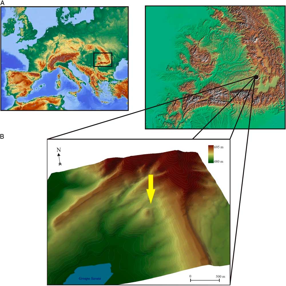
Kerek-tó (Round Lake) is situated in the southwestern foothills of the Hargita Mountains at an elevation of 547 m ASL near Homoródszentpál (Transylvania, Romania) (46°11′56.24′′N and 25°25′00.37′′E). It is a dried-up, human-made, rainwater reservoir lake used for animal drinking water (Figure 1). The wider surroundings of Homoródi Hills (Subcarpatii Homoroadelor: Posea Reference Posea2006) (Hajdú-Moharos et al. Reference Hajdú-Moharos, Sasi and Erős1992; Váradi and Lővey Reference Váradi and Lővey2000) are composed of Tertiary silty clay overlain by Late Tertiary–Quaternary volcanic tuff and tuffite layers (Pécskay et al. Reference Pécskay, Edelstein, Seghedi Szakacs, Kovacs, Crihan and Bernad1995; Szakács and Seghedi Reference Szakács and Seghedi1995). The catchment basin of the studied lake covers a small area, about 6 acres (2–3 hectares). The studied lake basin must have emerged as a result of downslope mass wasting promoted by thawing permafrost during the Late-Glacial/Postglacial transition (Vandenberghe et al. Reference Vandenberghe, French, Gorbunov, Marchenko, Velichko, Jin, Cui, Zhang and Wan2014; Ruszkiczay-Rüdiger and Kern Reference Ruszkiczay-Rüdiger and Kern2016; Tapody Reference Tapody2016) (Figure 1).
SMRT map of the Transylvania within the studied site (Round Lake at Homoródszentpál) (A) and the location of core site on the 3D map (B).

Today, both the surface of the dried-out lake and its surroundings form a wet-meadow with scattered shrubs and trees. At the end of the 19th century, the pond was dammed to provide drinking water for farm animals. This also protected the Holocene lake sediment and peat layers from dehydration, rendering them ideal for absolutely dated paleoecological studies. Moreover, as there are Medieval, Roman Imperial, and even older settlements in the vicinity of the site, so potential records of human impact on the site must have been preserved as well. The peat layers of the lake basin provide a record of climatic, paleoecological, and hydrological changes and are suitable to reconstruct the relationship between prehistoric human communities and their surrounding environment.
According to the initial radiocarbon (14C) dates, the 560-cm-long undisturbed core taken from the peat sequence of the pond holds records dating back ca. 7500 years, enabling the study of human and environment interactions from the Middle Neolithic onward. The main aim of the present work is to recognize the 14C-dated local climatic and environmental changes that took place in the second half of the Holocene in the summit areas of the southwestern foothill region of the Hargita Mountains in the Eastern Carpathians. This paper presents the results of a multidisciplinary study, the principle aims of which were to examine the long-term relationship between land degradation and human activity in the Homoród Hills using various palaeoecological techniques. In conjunction with a detailed review of regional archaeological data, these results detail for the long-term relationship between different prehistoric and historic cultures, technologies, and degradation of the landscape. Archaeological, 14C, and paleoecological evidence suggests that the studied region was occupied from the Early Neolithic, but the analyzed core sequence extends back only to the Middle Neolithic Age (5500 cal yr BC), so starting with the development of the Linear Pottery Culture (Hertelendi et al. Reference Hertelendi, Kalicz, Raczky, Horváth, Veres, Svingor, Futó and Bartosiewicz1995). The region has always been important in terms of its metallurgical industry (especially copper and iron production) with archaeological and historical records suggesting that a number of prehistoric cultures produced high-quality ceramic, copper, bronze, and iron objects from this region (Dumitrescu et al. Reference Dumitrescu, Bolomey and Mogoşanu1982; Härke Reference Härke1982; Collis Reference Collis1984; Mantu Reference Mantu1996, Reference Mantu1998; Dumitroaia Reference Dumitroaia2000; Bolohan Reference Bolohan2010; Lazarovici Reference Lazarovici2010; Wells Reference Wells2010; Boghian and Enea Reference Boghian and Enea2013; Harper Reference Harper2013).
MATERIALS AND METHODS
A 560-cm-long undisturbed core was taken using a 5-cm-diameter Russian-type corer from the center of the former lake (Jowsey 1966; Aaby and Digerfeldt Reference Aaby and Digerfeldt1986). Two overlapping cores were extracted, conforming to the general practice in Quaternary paleoenvironmental studies (Aaby and Digerfeldt Reference Aaby and Digerfeldt1986). After transportation to the laboratory, the cores were cut in half lengthwise. Sections for palaeobotanical and sedimentological analyses were stored at 4°C in accordance with the international standards. The cores were subsampled for further analysis at 2-cm intervals. The main lithostratigraphic features of the sedimentary sequence were determined and described using the internationally accepted system and symbols of Troels-Smith (Reference Troels-Smith1955), developed for unconsolidated sediments (Bennett Reference Bennett1992, Reference Bennett2005). To determine the organic, carbonate and inorganic content samples were subjected to LOI (loss-on-ignition) following the method presented by Dean (Reference Dean1974). The analysis is based on sequentially measuring weight loss in sub-samples after heating at selected temperatures. The samples were dried (24 hr at 105°C) prior to initial ignition at 550°C. Weight loss after 1 hr of combustion at 550°C can be used to calculate combusted organic material. In the third step, the same samples were ignited at 950°C to the breakdown temperature of carbonate.
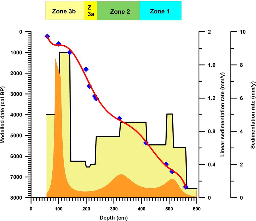
Ten peat and 2 charcoal samples were selected for 14C analysis from the core sequence. Accelerator mass spectrometry (AMS) 14C dating was performed in the Hertelendi Laboratory of Environmental Studies in the Institute for Nuclear Research of the Hungarian Academy of Sciences in Debrecen (Hungary) and DirectAMS Laboratory in Seattle (USA). The preparation of the samples and the actual steps of the measurement followed the methods of Hertelendi et al. (Reference Hertelendi, Csongor, Záborszky, Molnár, Gál, Győrffy and Nagy1989, Reference Hertelendi, Sümegi and Szöőr1992) and Molnár et al. (Reference Molnár, Janovics, Major, Orsovszki, Gönczi, Veres, Leonard, Castle, Lange, Wacker, Hajdas and Jull2013). Conventional 14C ages were converted to calendar ages using the software OxCal 4.2 online (Bronk Ramsey Reference Bronk Ramsey2009) and the most recent IntCal13 calibration curve (Reimer et al. Reference Reimer, Bard, Bayliss, Beck, Blackwell, Bronk-Ramsey, Buck, Cheng, Edwards, Friedrich, Grootes, Guilderson, Haflidason, Hajdas, Hatté, Heaton, Hogg, Hughen, Kaiser, Kromer, Manning, Niu, Reimer, Richards, Scott, Southon, Turney and van der Plicht2013) (Figure 2). Calibrated ages are reported as age ranges and mean age ±1 SD at the 2-sigma confidence level (95.4%). An age-depth model was contructed via Bayesian analysis (Bronk Ramsey Reference Bronk Ramsey2009) accounting with a varying sedimentation rate. From the constructed age-depth model, sedimentation rates (mm/year) have been calculated for 2-cm intervals.
Reconstructed age-depth curve and calculated linear sedimentation rates using 14C age tiepoints and calculated sedimentation rates for sampled intervals using the Bayesian age-depth model for core Round Lake at Homoródszentpál [Sânpaul, Romania].

Lake sediments were encountered on the top part of the peat sequence as well as in the form of thin intercalations, thus these samples were analyzed for grain-size distribution. Samples were pretreated with 1 M HCl and H2O2 to remove CaCO3 and organic matter respectively. For a more detailed description of the pretreatment process, see Konert and Vandenberghe (Reference Konert and Vandenberghe1997). Samples were measured using a laser particle size analyzer type OMEC Easysizer. The instrument records the distribution of 54 size classes between 0.0001 and 0.5 mm, relying on the Mie theory.
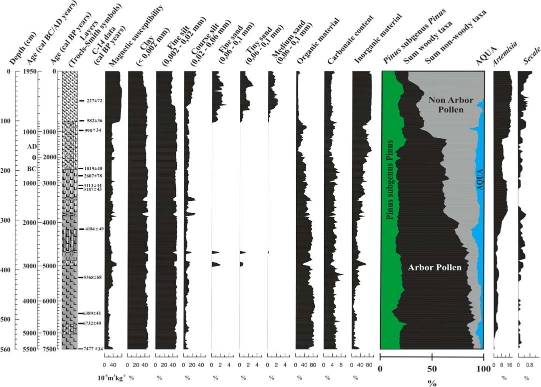
Environmental magnetic analyses were carried out on bulk samples (Thompson et al. Reference Thompson, Battarbee, O’Sullivan and Oldfield1975; Oldfield et al. Reference Oldfield, Thompson and Barber1978; Figure 3). Samples were taken at 2-cm intervals. Prior to the start of the measurement, all samples were crushed in a glass mortar after weighing. Then samples were cased in plastic boxes and air-dried in an oven at 40°C for 24 hr. Subsequently, magnetic susceptibilities were measured at a frequency of 2 kHz using an MS2 Bartington magnetic susceptibility meter with an MS2E high-resolution sensor (Dearing Reference Dearing1994). All of the samples were measured three times, and the average values of magnetic susceptibility were computed and reported. Principal component analyses computed on correlation matrices were preformed after logarithmic transformation of the geochemical data (Rollinson Reference Rollinson1993). The sedimentological and geochemical zones were identified by cluster analysis of principal components by using the squared Euclidean and Ward method (Zar Reference Zar1990).
Magnetic susceptibility, grain size, loss on ignition and most of the important pollen data from the sequence of the Round Lake at Homoródszentpál [Sânpaul, Romania].

Samples of 1 cm3 wet sediment for pollen analysis were processed at 4-cm intervals in the pollen laboratory of the Department of Geology and Paleontology at University Szeged using standard HF methods (Wood et al. Reference Wood, Gabriel and Lawson1996). Lycopodium spore tablets of known volume were added to each sample (Stockmarr Reference Stockmarr1971) to work out pollen concentrations. Pollen and spores were identified and counted under a light microscope at 400–1000× magnification. Following Magyari et al. (Reference Magyari, Chapman, Passmore, Allen, Huntley and Huntley2010), a minimum 500 pollen grains were counted. For the identification of pollen and spores the reference database at the Department of Geology and Paleontology, University of Szeged and pollen atlases and keys were used (Moore et al. Reference Moore, Webb and Collinson1991; Reille Reference Reille1992, Reference Reille1995, Reference Reille1998). The point-count method of Clark (Reference Clark1982) was applied to determine microcharcoal concentrations. Percentages of terrestrial pollen taxa, excluding Cyperaceae, were calculated using the sum of all those taxa. Percentages of Cyperaceae, aquatics, and pteridophyte spores were calculated relative to the main sum plus the relevant sum for each taxon or taxon group. Calculations, numerical analyses, and graphing of pollen diagrams were performed using the Psimpoll software package (Bennett Reference Bennett1992, Reference Bennett2005).
Our paleoecological results were compared to those derived from nearby archaeological sites (Dumitrescu Reference Dumitrescu, Bolomey and Mogoşanu1982; Härke Reference Härke1982; Collis Reference Collis1984; Hertelendi et al. Reference Hertelendi, Kalicz, Raczky, Horváth, Veres, Svingor, Futó and Bartosiewicz1995; Mantu Reference Mantu1996, Reference Mantu1998; Dumitroaia Reference Dumitroaia2000; Bolohan Reference Bolohan2010; Lazarovici Reference Lazarovici2010; Wells Reference Wells2010; Boghian and Enea Reference Boghian and Enea2013; Harper Reference Harper2013; Boghian et al. Reference Boghian, Enea, Pîrnău and Secu2014) and to the latest paleoclimatological and paleoecological models for Transylvania (Feurdean et al. Reference Feurdean, Galka, Kuske, Tantau, Lamentowicz, Florescu, Liakka, Hutchinson, Mulch and Hickler2015; Diaconu et al. Reference Diaconu, Tóth, Lamentowicz, Heiri, Kuske, Tanţău, Panait, Braun and Feurdean2017; Longman et al. Reference Longman, Ersek, Veres and Salzmann2017).
RESULTS AND DISCUSSION
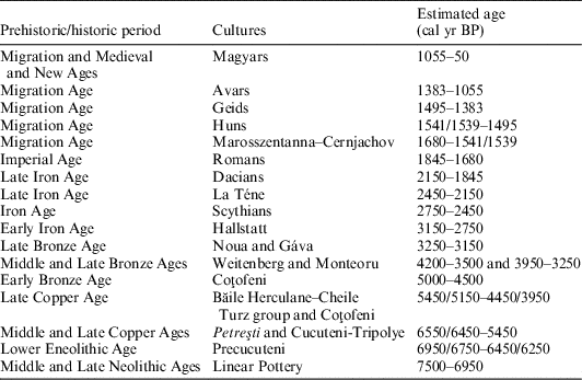
Archeological evidence suggests that the Homoród Hills were occupied from the Early Neolithic onward (Tables 1–3), starting with the development of the Transylvanian Körös (Criş) Culture between approximately 8250–7500 cal BP (6250–5500 cal yr BC: Hertelendi et al. 1996; Biagi and Spataro Reference Biagi and Spataro2005; Lazarovici Reference Lazarovici2010). However, the analyzed core sediment sequence only started forming about the time of development of Linear Pottery Culture, ca. 5500/5300 BC years. The region has always been important in terms of its metallurgical industry (especially copper and iron production) with archaeological and historical records suggesting that a number of prehistoric cultures produced high-quality ceramics, copper, bronze, and iron objects from this region (Popescu Reference Popescu1956; Bouzek Reference Bouzek1973; Biagi et al. Reference Biagi, Gratuze and Boucetta2007; Vasilescu et al. Reference Vasilescu, Constantinescu and Bugoi2011).
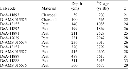
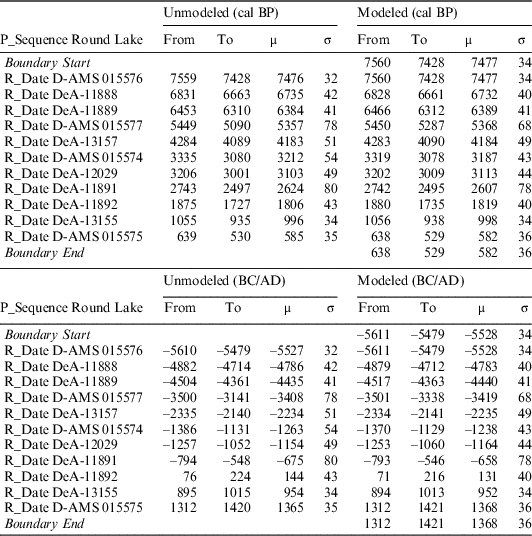
Results of 14C AMS analysis.

Calibrated and modeled age ranges received via Bayesian modeling using varying deposition rates.

Main prehistorical and historical periods as identified by archaeological remains in the Homoród Hills (based on Dumitrescu et al. Reference Dumitrescu, Bolomey and Mogoşanu1982; Härke Reference Härke1982; Collis Reference Collis1984; Mantu Reference Mantu1996; Mantu Reference Mantu1998; Dumitroaia Reference Dumitroaia2000; Bolohan Reference Bolohan2010; Lazarovici Reference Lazarovici2010; Wells Reference Wells2010; Boghian and Enea Reference Boghian and Enea2013; Harper Reference Harper2013).

Conventional 14C ages are reported by sample name, depth, and type (Table 1). Samples taken at relatively even intervals between 59 and 560 cm yielded conventional ages between 230±21 yr BP and 6575 ± 29 yr BP. According to the results of calibration and modeling (Table 2) sediment accumulation must have started between 7560 and 7428 cal yr BP [5611–5479 cal BC (95.4%)]. The calibrated age of the topmost charcoal sample at a depth of 59 cm was extremely wide (299–0 cal yr BP) due to fluctuations in the 14C calibrated curve in the last 300 years. Due to the large scatter after calibration and an estimated deposition rate of 0 according to the constructed probability model, this data was omitted from further analysis. Thus, reliable dates are available for the depth interval between 100 and 560 cm and sediment accumulation must have come to an end between 638 and 529 cal BP [1312–1421 cal BC (95.4%)] years. As shown in Table 3, the sequence holds records from the Middle Neolithic all the way to the early Middle Ages.
The age-depth model established for the sequence is depicted in Figure 2. Average linear sedimentation rate (ASR) is rounded to 0.75 mm/year. However, this rate has changed several times between 0.15 and 1.7 mm/year over the entire core (Figure 2). The pattern of change is similar for linear sedimentation rates and those estimated using the received age-depth model for 2 cm intervals. In this latter case, calculated sedimentation ranged between 0.08 and 9 mm/year. Apart from an initial rise observed at the start of sequence and some minor peaks at 6500 and 4300 cal yr BP and subsequent lows at 5500 and 2200 cal yr BP (Figure 2) sedimentation rates are relatively constant. There is a marked increase in the sequence from about 800 cal yr BP, representing the last stage of lake and peatbog evolution to rates around 1.7 mm/year (linear model) and 8 mm/year as a result of increased erosion.
The first sedimentological–geochemical zone (Zone 1) (547–388 cm) developed between 7500 and 5000 cal yr BP and corresponds to the period from the Middle Neolithic to the late Copper Age in Carpathian Basin. This period showed the highest organic matter concentration, above 90%. The arboreal pollens were dominant before human appearance and mesophilic deciduous trees were dominated (60% above) lime (Tilia), elm (Ulmus), oaks (Quercus), hazel (Corylus) and the coniferous vegetation was constant (20%) in the whole sequence (Figure 3, supplementary Figures S1–3). From the middle Neolithic to the end of copper age 7500–5300 cal yr BP (between 560 and 416 cm), the linear sediment accumulation rate is lower than the average at 0.65 mm·yr–1 (Figure 2). On the non-linear curve in the Zone 1 after a sharp rise there is a minor peak corresponding to the middle part of the zone followed by a small decrease and relatively constant values toward the end of the zone. The surroundings of Round Lake must have had a significant vegetation cover to hold erosion rates to a minimum compared to later periods. The slower rate of woodland expansion and erosion indicates the presence of small communities and non-significant human impact on the catchment of the lake.
The second zone (Zone 2) (388–236 cm) covers the period from the end of the Copper Age to the end of Bronze Age between 5000 and 3200 cal yr BP. The section has variable organic content averaging around 50%. The earlier thermophilous, mesophilous deciduous woodland species (Tilia-lime, Ulmus-elm, Corylus-hazel) have retreated surrounding the lake.There is a marked increase in beech (Fagus) and hornbeam (Carpinus) in the arboreal pollen indicating the emergence of cooler and wetter climatic conditions (Figure 3, supplementary Figures S1–3). There is an increase in both the inorganic content of the deposits parallel to the ratio of non-arboreal pollen, which implies increasing deforestation and human-induced erosion in the catchment. The linear accumulation rate increased gradually between 416 and 236 cm from 0.65 to 0.87 mm·yr–1. A similar pattern is recorded on the non-linear accumulation rate curve as well (Figure 2). It must be noted though that this increase was not greater than the one seen for the middle part of Zone 1. The increasing sedimentation rate was likely due to increased technical development and number of human communities, which would enhance erosion and accelerate biogenous accumulation due to the cooler, wetter climate. In this period the area was occupied by Cotofeni culture in the Early Bronze age and was followed by Weitenberg and Monteoru Culture (Table 3).
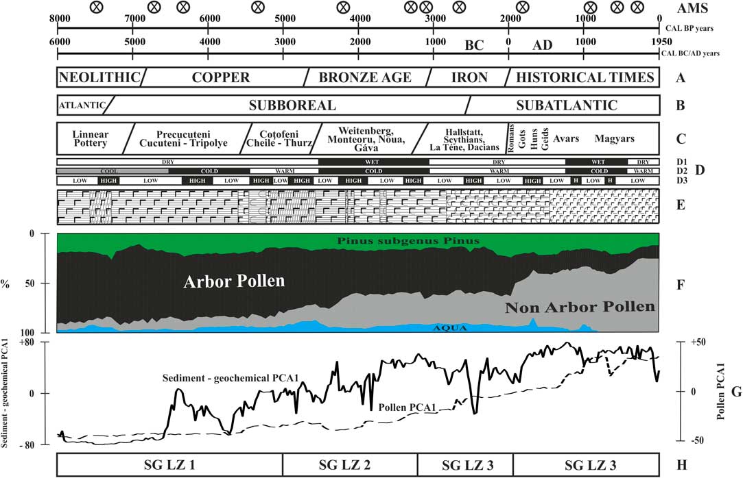
Between 236–199 cm, Zone 3a represents the period from the late Bronze Age to the Roman Age (3200–1900 cal yr BP). Linear accumulation rates continued to decline to 0.43 mm·yr–1. and reached their lowest of the entire profile (0.15 mm·yr–1) between 211–199 cm, with the exception of the start of the core. A similar trend is seen in the non-linear sedimentation curve as well. The gradually decreasing accumulation rates are attributable to a significant reduction of the available space caused by gradual infilling and reduced erosion. We can attribute these changes to the occurrence of various Iron Age cultures (Hallstatt, Scythians, La Tène cultures) and the upheaval of the Dacian Kingdom impacting the catchment area of the lake (Figure 4).
Synthetic representation of the second half of the Holocene human and climatic environment in the context of paleoecological, and paleoclimatological data from Transylvania and Round Lake at Homoródszentpál (Sânpaul, Romania). AMS = AMS radiocarbon measuring point, A = archaeological and historical horizons, B = Blytt – Sernander systeme, C = archaeological and historical cultural horizons (based on Dumitrescu Reference Dumitrescu, Bolomey and Mogoşanu1982; Härke Reference Härke1982; Collis Reference Collis1984; Hertelendi et al. Reference Hertelendi, Kalicz, Raczky, Horváth, Veres, Svingor, Futó and Bartosiewicz1995; Mantu Reference Mantu1996, Reference Mantu1998; Dumitroaia Reference Dumitroaia2000; Bolohan Reference Bolohan2010; Lazarovici Reference Lazarovici2010; Boghian and Enea Reference Boghian and Enea2013; Harper Reference Harper2013; Boghian et al. Reference Boghian, Enea, Pîrnău and Secu2014; Wells Reference Wells2010), D = paleoclimatological data, D1 = humidity of NW Transylvania (Feurdean et al. Reference Feurdean, Galka, Kuske, Tantau, Lamentowicz, Florescu, Liakka, Hutchinson, Mulch and Hickler2015; Diaconu et al. Reference Diaconu, Tóth, Lamentowicz, Heiri, Kuske, Tanţău, Panait, Braun and Feurdean2017; Longman et al. Reference Longman, Ersek, Veres and Salzmann2017), D2 = temperature changes in the second part of Holocene in the NW Transylvania (Feurdean et al. Reference Feurdean, Galka, Kuske, Tantau, Lamentowicz, Florescu, Liakka, Hutchinson, Mulch and Hickler2015; Diaconu et al. Reference Diaconu, Tóth, Lamentowicz, Heiri, Kuske, Tanţău, Panait, Braun and Feurdean2017), D3 = Mid-European high lake levels after Magny (Reference Magny2004), E = core sequence within Troels-Smith symbols (Troels-Smith Reference Troels-Smith1955) in Round Lake at Homoródszentpál (Sânpaul, Romania), F = AP, NAP and AQUA pollen summary from the core sequence in Round Lake at Homoródszentpál (Sânpaul, Romania), G = result of the principal component analyses of the pollen and sedimentological, geochemical data from the core sequence in Round Lake at Homoródszentpál (Sânpaul, Romania) PCA1Sediment geochemistry: indicates shifts in erosion rates, PCA1Pollen: indicate degree of arboreal vegetation cover (rest of the PCs were not considered), H = local sedimentological–geochemical zones in the core sequence in Round Lake at Homoródszentpál (Sânpaul, Romania).

There is a sharp increase in sedimentation in Zone 3b (top 200 cm of the core). Linear accumulation rates peaked around 1.15 mm·yr–1 at 100 cm. This interval corresponds to the periods of the Late Imperial Age, the time of the Great Migration (Huns, Avars) and Hungarian Conquest (1900–900 cal yr BP). The appearance of these nomadic cultures put an increased pressure on the landscape via increasing deforestation, arable lands, and pasturelands as well as intensive grazing. This is seen in not only an increase in sedimentation rates but also in the sharp increase of the inorganic content and NAPs (Figures 2 and 3). Creation of fishing ponds by damming the peatbog also lead to the cessation of peat formation.
CONCLUSION
According to our findings, accumulation rates display periodic changes in the studied lacustrine sequence due to the interaction of more complex processes than simple erosion in the catchment areas. Precipitation and temperature must have had a very strong influence on the vegetation growth around Round Lake. Due to increasing human pressure on the landscape, erosion increased, apparently leading to periodic interruption, gradual deceleration and finally cessation of biogenic material accumulation in the basin. The establishment of a fishing pond during the early Middle Ages almost led to the elimination of aquatic elements from the bog (Figure 3).
These changes are clearly observable in the periodical changes in MS, grain size, organic matter and carbonate data and wavelike fluctuations of the PCA curves expressing the most important component of sediment-geochemical variations (Figure 4). Positive excursions are predominantly correlated with periodic increases in coarse silt and sand, implying human-induced erosion. This is also seen in the presence of indicator weeds, wheat and other cultured plant pollen grains (Figure 3, supplementary Figures S1–3) as well as increases in NAP (Figures 3–4).
Erosion events are especially pronounced in those parts of the profile when more humid climatic conditions are apparent in the Transylvanian Basin (Feurdean et al. Reference Feurdean, Galka, Kuske, Tantau, Lamentowicz, Florescu, Liakka, Hutchinson, Mulch and Hickler2015, Reference Feurdean, Florescu, Vannière, Tanţău, O’Hara, Pfeiffer, Hutchinson, Gałka, Moskal-del Hoyo and Hickler2017; Diaconu et al. Reference Diaconu, Tóth, Lamentowicz, Heiri, Kuske, Tanţău, Panait, Braun and Feurdean2017) and not solely increased human impacts (Figure 4). Nevertheless, our record shows many more periods of increased or decreased bog surface wetness then these coeval regional paleoeclimatic records (Schnitchen et al. Reference Schnitchen, Charman, Magyari, Braun, Grigorszky, Tóthmérész, Molnar and Szántó2006; Feurdean et al. Reference Feurdean, Liakka and Vannière2013; Tóth et al. Reference Tóth, Magyari, Buczkó, Braun, Panagiotopoulos and Heiri2015; Diaconu et al. Reference Diaconu, Tóth, Lamentowicz, Heiri, Kuske, Tanţău, Panait, Braun and Feurdean2017).
Higher organic content, expressing the dominance of peat in the bog, also indicates the development of humid and cool climatic conditions. These do, however, become gradually suppressed. There is a marked cessation in the accumulation of organic matter in our profile during a period when all other regional and extraregional Transylvanian (Schnitchen et al. Reference Schnitchen, Charman, Magyari, Braun, Grigorszky, Tóthmérész, Molnar and Szántó2006; Feurdean et al. Reference Feurdean, Liakka and Vannière2013; Tóth et al. Reference Tóth, Magyari, Buczkó, Braun, Panagiotopoulos and Heiri2015; Diaconu et al. Reference Diaconu, Tóth, Lamentowicz, Heiri, Kuske, Tanţău, Panait, Braun and Feurdean2017; Longman et al. Reference Longman, Ersek, Veres and Salzmann2017) and Central European (Magny Reference Magny2004; Demény et al. Reference Demény, Czuppon, Siklósy, Leél-Őssy, Lin, Shen and Gulyás2013; Náfrádi et al. Reference Náfrádi, Jakab, Sümegi, Szelepcsényi and Törőcsik2013) paleoclimatological records indicate the development of humid and cool conditions during the Bronze Age. In our view, human influence crossed a threshold in the local environment when intensive deforestation led to the warming of the bog surface and the extinction of the peat moss vegetation. This is evident from the pollen data. Similar observations were made for the periods of the Iron Age and the Age of Great Migration (Figure 4). The observed human pressure on the landscape during the late Migration Period and the early Medieval Age can be clearly linked to the rebuilding and reuse of the Roman Imperial fortress at the Round Lake during the Avar Age and in the early stages of the Kingdom of Hungary. These observed human-induced changes can be correlated with those recorded for other parts of the Carpathian Basin (Willis et al. Reference Willis, Sümegi, Braun, Bennett and Tóth1998; Sümegi et al. Reference Sümegi, Jakab, Majkut, Törőcsik and Zatykó2009; Magyari et al. Reference Magyari, Chapman, Passmore, Allen, Huntley and Huntley2010).
ACKNOWLEDGMENTS
The research was supported by the European Union and the State of Hungary, co-financed by the European Regional Development Fund in the project of GINOP-2.3.2-15-2016-00009 “ICER”.
Supplementary material
To view supplementary material for this article, please visit https://doi.org/10.1017/RDC.2018.38